Showing 45 items matching "surveyors level"
-
 Flagstaff Hill Maritime Museum and Village
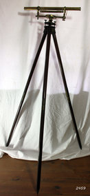
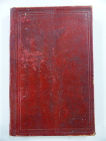
Instrument - Drainage Level, 1750-1795
... ...surveyors level...Having one of their early drainage levels in the collection and in extremely good condition is an asset to the Flagstaff collection. flagstaff hill warrnambool shipwrecked-coast flagstaff-hill flagstaff-hill-maritime-museum maritime-museum shipwreck-coast flagstaff-hill-maritime-village george adams fleet street london optical instrument scientific instrument technical instrument surveyors level george adams snr projection microscope "G. ...Adams jnr wrote many elementary scientific works, as well as on the use of mathematical instruments. He often combined in his written works with religious themes and scientific content, often against the prevailing thoughts of the time. According to one popular magazine of the time (Gentleman's Magazine), his works were often accused of "growing errors of materialism, infidelity, and anarchy". He started writing at a young age and developed a love for it, his main interests included math and science, these subjects he often expressed in his written essay's. Notable works from Adams are. An Essay on Electricity, and Magnetism (1784). Essays on the Microscope (1787). An Essay on Vision, briefly explaining the fabric of the eye (1789). Astronomical and Geographical Essays (1790). A Short Dissertation on the Barometer (1790). Geometrical and Graphical Essays, containing a description of the mathematical instruments used in geometry, civil and military surveying, leveling and perspective (1790). Lectures on Natural and Experimental Philosophy, in five volumes (1794).George Adams Sr and Jnr were both notable opticians and scientific instrument makers of the 18th century. Their contribution to scientific innovation and optical development cannot be underestimated. Having one of their early drainage levels in the collection and in extremely good condition is an asset to the Flagstaff collection.Drainage level or optical level. A brass surveying instrument with Achromatic telescope, bubble level and dial fitted to the Tribrach or footplate that has leveling screws. Tripod is wood and brass with adjustable and unscrewable legs (for ease of transportation). Made by "G. Adams Fleet St, London". Used in surveying and building to transfer, measure and/or set horizontal levels."G. Adams - London".flagstaff hill, warrnambool, shipwrecked-coast, flagstaff-hill, flagstaff-hill-maritime-museum, maritime-museum, shipwreck-coast, flagstaff-hill-maritime-village, george adams fleet street london, optical instrument, scientific instrument, technical instrument, surveyors level, george adams snr, projection microscope -
 Melbourne Tram Museum
Document - Research Notes, H. S. McComb, MTT & MTOCo authorised lines, c1956
... Notes, 13 pages foolscap sheets pinned in the top left hand corner, 2 loose foolscap pages, 6 quarto pages, providing a sketch map of the MTOCo lines as authorised, length of each line, description, extract from surveyors level books for dates, list of cable car depots and financial notes. ...Melbourne Tram Museum 8 Wallen Road Hawthorn melbourne Trams tramways MTO Co Cable Trams Drawings Reports Surveys Notes, 13 pages foolscap sheets pinned in the top left hand corner, 2 loose foolscap pages, 6 quarto pages, providing a sketch map of the MTOCo lines as authorised, length of each line, description, extract from surveyors level books for dates, list of cable car depots and financial notes. ...Notes, 13 pages foolscap sheets pinned in the top left hand corner, 2 loose foolscap pages, 6 quarto pages, providing a sketch map of the MTOCo lines as authorised, length of each line, description, extract from surveyors level books for dates, list of cable car depots and financial notes. Items 2064 to 2075 within box 72.3 in a brown folder marked "MT&O Co." red pencil on the front cover.trams, tramways, mto co, cable trams, drawings, reports, surveys -
 Federation University Historical Collection
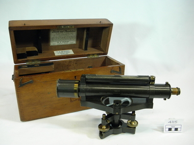
Instrument, W. H. Stanley, Surveying level, July 1899
... Surveyor's level caste in metal with brass trimmings. ...Great Turnstile Holborn, London. Surveyor's level caste in metal with brass trimmings. ...Used by students attending surveying classes at the School of Mines & Industries, Ballarat.Surveyor's level caste in metal with brass trimmings. Features external focus, twin inclined vertical crosshairs with stadia wires. With ray-shade clinomenter. Three levelling screws. Without transverse level (mounting provided). dust shield for object. Features glass lens x 2. Timber carry case features dovetailed joints, separate lid attached to body of case with two brass piano hinges along back side. Case has a metal carry handle screwed to each end. Matches tripod Item 4116 Item's serial number: 99142*The timber lid of the carry case has 'L3' painted on it in white paint. *The paper label glued to reverse side lid of inside carry box reads: STANLEY'S PATENT LEVELS AND THEODOLITES No.99142 July 1899 STADIA POINTS SET=1 : 100. In taking readings of a distant staff by means of the subtense points in the diaphragm, read every 1/100 foot (or metre) on the staff as being equal to one foot (or metre) of distance from the centre of the instrument adding to the reading of plus constant of 18 3/4 inchess from any distance shown. W.F. Stanley, Great Turnstile, Holborn, London. *The paper label glued to lower edge inside lid of carry box reads: N. H. SEWARD, "Optical House" 457 BOURKE STREET (Near Queen Street) MELBOURNE *Engraving on brass plate encompassing the catch on front edge of the timber carry case reads: H&C L (inside an engraved heart on LSH) EUCHRE LEVER (engraved on RHS of brass plate) *Maker's mark is engraved along the length of the telescope barrel: 99142 Stanley. Great Turnstile Holborn, London. level, theodolite, surveying instrument, surveying, scientific instruments -
 Ballarat Tramway Museum
Photograph - Digital image, W. J. Llewelyn, c1980
... Could be early 1954, given the works at Johns Valves - Photo taken at the same time as btm6845i.. Note the surveyor and level in the middle bottom of the photograph....Could be early 1954, given the works at Johns Valves - Photo taken at the same time as btm6845i.. Note the surveyor and level in the middle bottom of the photograph. ...Yields information about the Ballarat Power Station B soon after construction and the precinct.Colour digital images taken by W. J. Llewelyn of Ballarat B Power Station, Norman St with a view showing some of the roof mounted equipment and looking towards the Wendouree suburb with Norman St in the view.. Could be early 1954, given the works at Johns Valves - Photo taken at the same time as btm6845i.. Note the surveyor and level in the middle bottom of the photograph.trams, tramways, ballarat b power station, secv, manufacturing, norman st -
 Warrnambool and District Historical Society Inc.
Book, John Ross notebook, 1890s
... This small note book belonged to John Ross, the Warrnambool Town Surveyor and Engineer (1889-1906 & 1913-1914). The book lists the levels taken for the benefit of contractors undertaking jobs for the Warrnambool Council from 1898 to 1902. ...Warrnambool and District Historical Society Inc. 2 Gilles Street (south of Merri St) Warrnambool great-ocean-road This small note book belonged to John Ross, the Warrnambool Town Surveyor and Engineer (1889-1906 & 1913-1914). The book lists the levels taken for the benefit of contractors undertaking jobs for the Warrnambool Council from 1898 to 1902. ...This small note book belonged to John Ross, the Warrnambool Town Surveyor and Engineer (1889-1906 & 1913-1914). The book lists the levels taken for the benefit of contractors undertaking jobs for the Warrnambool Council from 1898 to 1902. The jobs include ‘Russells Creek from the Merri River upwards’, ‘Outlet at the Flume’, ‘Guns at the Battery’ and Drainage from the Terminus Hotel to the end of the Japan Street Tunnel’. John Ross was also in private practice with the architectural firm of Ross and Jackman. This notebook is of considerable interest because it is an original note book that belonged to John Ross, the Warrnambool Town Surveyor and Engineer in the late 19th century and early 20th century. The note book contains important information on the engineering projects in Warrnambool and district from 1898 to 1902. This note book has a red leather cover. The cover is a little creased. The inside pages have ruled red lines and printed headings regarding the levels taken of a site and the location of the site (1898 to 1902). The engineer’s entries in the printed columns are handwritten , mostly in pencil. The inscription on the first page is handwritten in black ink. ‘Jno C Ross, Town Surveyor Wbool 19/5/98’ john ross, warrnambool town council, history of warrnambool -
 Bendigo Military Museum
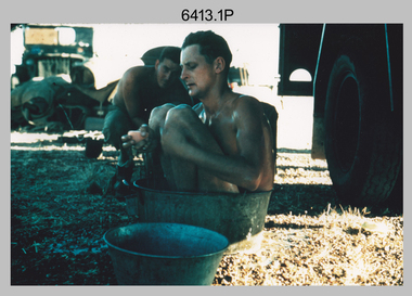
Photograph - Royal Australian Survey Corps Surveyors in the Field – North Queensland, 1958
... Surveyors south of Richmond, QLD erecting a Bilby observation tower. L to R: Tom Royle, Bob Skitch (on ground level), Mal Hayes. .6) - Photo, colour, 1958. ...Surveyors south of Richmond, QLD erecting a Bilby observation tower. L to R: Tom Royle, Bob Skitch (on ground level), Mal Hayes. .6) - Photo, colour, 1958. ...This is a set of seven photographs of surveyors and support staff in the field undertaking duties in North Queensland in 1958. The surveyors were employed in the establishment of mapping and geodetic control. In this era surveyors used theodolites to observe horizontal and vertical angles and chains to measure base line distances between survey stations. Bob Skitch shown in photos .4P to .6P was in the 2nd year of his career in the Australian Army. He achieved the rank of Lieutenant Colonel and his last appointment was the CO of the Army Survey Regiment from 1976 to 1980. The annotation on the back of photo .5P ‘Black foreground is where Bob Skitch boiled billy and started a grass fire’.This is a set of seven photographs of surveyors and support staff in the field undertaking duties in North Queensland in 1958. The photographs were printed on photographic paper and are part of the Army Survey Regiment’s Collection. The photographs were scanned at 300 dpi. .1) - Photo, colour, 1958. Surveyor in Nth QLD enjoying a bath. L to R: Don Cocker, Bob Thompson. .2) - Photo, colour, 1958. Don Cocker surveyor in Nth QLD, enjoying a bath. .3) - Photo, colour, 1958. Surveyors Nth QLD undertaking survey observations, using MRA1 tellurometer to measure base-line distances. L to R: Len Davies, Lou Sommer, John Van De Graff. MRA1 was covered to stop overheating. .4) - Photo, colour, 1958. Surveyors south of Richmond, QLD digging holes for the erection of a Bilby observation tower. L to R: John Van De Graff, Bob Skitch, Kev Moody, Mal Hayes, Don Gray .5) - Photo, colour, 1958. Surveyors south of Richmond, QLD erecting a Bilby observation tower. L to R: Tom Royle, Bob Skitch (on ground level), Mal Hayes. .6) - Photo, colour, 1958. Surveyors south of Richmond, QLD erecting a Bilby observation tower. L to R: Tom Royle, Bob Skitch, Mal Hayes, Jim McGill (on ground level). .7) - Photo, colour, 1958. Surveyors south of Richmond, QLD undertaking survey measurements from a Bilby observation tower..1P to .7P annotated on back – personnel names, the year and the location. Annotated on back of .5P ‘Black foreground is where Bob Skitch boiled billy and started a grass fire’.royal australian survey corps, rasvy, army survey regiment, asr, army svy regt, fortuna, surveying -
 Bendigo Military Museum
Photograph - RA Svy Project C4 Aerodist Operation, Eastern & Western Arnhem Land, NT, 1967, 1968
... They are part of the Army Survey Regiment’s Collection. .1) to .2) – Photo, black & white, 1968, unidentified soldier with an opened can of food, possibly bully beef. .3) – Photo, black & white, 15 Aug 1968, aerial view of terrain taken from a helicopter in vicinity of MILINGIMBI SIERRA. .4) – Photo, black & white, 1967, aerial view of an island taken from a helicopter. .5) & .6) – Photo, black & white, 1967, unidentified soldier driving a Haflinger 4x4 Light utility vehicle with trailer. .7) – Photo, black & white, 1967, unidentified surveyors taking vertical measurements with a leveling instrument and staff. .8) – Photo, black & white, 1967, Australian Army Sioux Light Observation Helicopter (LOH) with float removed. .9) to .11) – Photo, black & white, 1967, Australian Army Sioux Light Observation Helicopter (LOH) with floats. .12) – Photo, black & white, 1967, civilian Bell 47G-2 helicopter (Australian Army Sioux LOH equivalent) refuelled. .13) – Photo, black & white, 1967, survey station on coastline surrounded by white plastic aerial photographic identification panels lined with rocks. .14) & .15) – Photo, black & white, 1967, soldier (possibly a signaller from RA Sigs) operating a radio. .16) – Photo, black & white, 1967, Central Comd Fd Svy Unit Operations Section tent, Main Base Gove (Nhulunbuy) L to R: SPR Harry Dunn, WO1 Pat Wood BEM. .17) – Photo, black & white, 1967, Central Comd Fd Svy Unit Operations Section tent, Main Base Gove (Nhulunbuy) L to R: unidentified, WO1 Pat Wood BEM. .18) – Photo, black & white, 1967, Central Comd Fd Svy Unit Operations Section, Main Base Gove (Nhulunbuy), unidentified Australian Army Catering Corps cook preparing meals. .19) – Photo, black & white, 1967, Central Comd Fd Svy Unit Operations Section, Main Base Gove (Nhulunbuy) mess tent in readiness for meals. .20) – Photo, black & white, 1967, Bank of batteries in transit boxes undergoing recharging using generators. .21) – Photo, black & white, 1967, A topographic survey identification plaque set in a concrete block being weighed using a set of scales hanging from slaughtering gallows. .22) – Photo, black & white, 1967, CPL (Geoff or Gary) Larkin operating the remote Aerodist MRC2 ground instrument at Veronica Island, located north of Nhulunbuy. .23) – Photo, black & white, 1967, L to R: CPL (Geoff or Gary) Larkin with unidentified surveyor operate the remote Aerodist MRC2 ground instrument at Venica Island, located north of Nhulunbuy. .24) & .25 – Photo, black & white, 1967, The Aerodist MRC2 Remote antenna. .26) – Photo, black & white, 1967, The Aerodist MRC2 Remote antenna....They are part of the Army Survey Regiment’s Collection. .1) to .2) – Photo, black & white, 1968, unidentified soldier with an opened can of food, possibly bully beef. .3) – Photo, black & white, 15 Aug 1968, aerial view of terrain taken from a helicopter in vicinity of MILINGIMBI SIERRA. .4) – Photo, black & white, 1967, aerial view of an island taken from a helicopter. .5) & .6) – Photo, black & white, 1967, unidentified soldier driving a Haflinger 4x4 Light utility vehicle with trailer. .7) – Photo, black & white, 1967, unidentified surveyors taking vertical measurements with a leveling instrument and staff. .8) – Photo, black & white, 1967, Australian Army Sioux Light Observation Helicopter (LOH) with float removed. .9) to .11) – Photo, black & white, 1967, Australian Army Sioux Light Observation Helicopter (LOH) with floats. .12) – Photo, black & white, 1967, civilian Bell 47G-2 helicopter (Australian Army Sioux LOH equivalent) refuelled. .13) – Photo, black & white, 1967, survey station on coastline surrounded by white plastic aerial photographic identification panels lined with rocks. .14) & .15) – Photo, black & white, 1967, soldier (possibly a signaller from RA Sigs) operating a radio. .16) – Photo, black & white, 1967, Central Comd Fd Svy Unit Operations Section tent, Main Base Gove (Nhulunbuy) L to R: SPR Harry Dunn, WO1 Pat Wood BEM. .17) – Photo, black & white, 1967, Central Comd Fd Svy Unit Operations Section tent, Main Base Gove (Nhulunbuy) L to R: unidentified, WO1 Pat Wood BEM. .18) – Photo, black & white, 1967, Central Comd Fd Svy Unit Operations Section, Main Base Gove (Nhulunbuy), unidentified Australian Army Catering Corps cook preparing meals. .19) – Photo, black & white, 1967, Central Comd Fd Svy Unit Operations Section, Main Base Gove (Nhulunbuy) mess tent in readiness for meals. .20) – Photo, black & white, 1967, Bank of batteries in transit boxes undergoing recharging using generators. .21) – Photo, black & white, 1967, A topographic survey identification plaque set in a concrete block being weighed using a set of scales hanging from slaughtering gallows. .22) – Photo, black & white, 1967, CPL (Geoff or Gary) Larkin operating the remote Aerodist MRC2 ground instrument at Veronica Island, located north of Nhulunbuy. .23) – Photo, black & white, 1967, L to R: CPL (Geoff or Gary) Larkin with unidentified surveyor operate the remote Aerodist MRC2 ground instrument at Venica Island, located north of Nhulunbuy. .24) & .25 – Photo, black & white, 1967, The Aerodist MRC2 Remote antenna. .26) – Photo, black & white, 1967, The Aerodist MRC2 Remote antenna. ...This is a set of 26 photographs of Royal Australian Survey Corps (RA Svy) personnel from Central Comd Fd Svy Unit (Adelaide) on Aerodist survey operation - Project C4 in Eastern Arnhem Land, Northern Territory in 1967 (photos .4P to .26P) and in Western Arnhem Land, Northern Territory in 1968 (photos .1P to .3P). Photos of personnel were taken either at the operations base at Numbulwar or the main base at Gove (Nhulunbuy). RA Svy conducted nineteen Aerodist operations for 12 years from 1964 to 1975. Aerodist MRC2 was a tellurometer-based system adapted for aircraft to accurately measure distances between non-intervisible ground survey stations, using the aircraft as an intermediate station. Lower order geodetic results could be achieved by survey network trilateration. The measured distances between stations formed survey networks from which each station’s latitude and longitude was computed. Aerodist MRC2 was RA Svy’s major horizontal control survey tool for mainly medium scale topographic mapping (scale 1:100,000 Class A being spatially accurate to within 50 metres) in PNG, northern NT, north-west WA, Kalimantan Barat (West) Indonesia, Sumatra Indonesia, Gulf of Carpentaria and Cape York, QLD. In 1967, the Aerodist MRC2 Master equipment was installed in the aircraft featured in this set of photos, Executive Air Services’ (Essendon VIC) Grand Aero Commander VH-EXX. It was the same aircraft type and company contracted to Division of National Mapping for Aerodist MRC2 surveys. From July to October 1967 the aircraft was attached to Central Comd Fd Svy Unit (Adelaide - Major Don Ridge) on Project C4 eastern-Arnhem Land NT, where 317 Aerodist lines measuring 17,300 line miles were successfully completed. This was the most productive Aerodist project thus far. The most common helicopter used by RA Svy up to 1972 was the civilian Bell 47G-2 and the Sioux Light Observation Helicopters (LOH), the Australian Army’s equivalent featured in this photo set. These light observation helicopters had a limiting load carrying capacity of up to about 500 pounds. By comparison, one Aerodist team including two people weighed up to 1,500 pounds. In 1968, after completion of the Kimberley Aerodist Operation project, the Aerodist system in VH-EXX was immediately deployed to western-Arnhem Land NT for Central Comd Fd Svy Unit (Adelaide - Major Don Ridge) to complete the mapping control across northern NT from mid-July to October. The Aerodist MRC2 Remote antenna seen in Photos .24P to .26P is mounted on a 20 foot pole tower. The antenna direction was controlled by wires/ropes to the two arms under the dish at right angles. The antenna elevation could be changed to the vertical for aircraft height checks as seen in photo .25P. Source: Royal Australian Survey Corps – Aerodist Years 1964-1975 by Peter Jensen. Refer to Item 6449.30P for more photos taken during these Aerodist survey operations.This is a set of 26 photographs of Royal Australian Survey Corps (RA Svy) personnel on Aerodist survey operations in Eastern Arnhem Land, Northern Territory in 1967 and Western Arnhem Land, Northern Territory in 1968. The photographs are on 35mm negative film and scanned at 96 dpi. They are part of the Army Survey Regiment’s Collection. .1) to .2) – Photo, black & white, 1968, unidentified soldier with an opened can of food, possibly bully beef. .3) – Photo, black & white, 15 Aug 1968, aerial view of terrain taken from a helicopter in vicinity of MILINGIMBI SIERRA. .4) – Photo, black & white, 1967, aerial view of an island taken from a helicopter. .5) & .6) – Photo, black & white, 1967, unidentified soldier driving a Haflinger 4x4 Light utility vehicle with trailer. .7) – Photo, black & white, 1967, unidentified surveyors taking vertical measurements with a leveling instrument and staff. .8) – Photo, black & white, 1967, Australian Army Sioux Light Observation Helicopter (LOH) with float removed. .9) to .11) – Photo, black & white, 1967, Australian Army Sioux Light Observation Helicopter (LOH) with floats. .12) – Photo, black & white, 1967, civilian Bell 47G-2 helicopter (Australian Army Sioux LOH equivalent) refuelled. .13) – Photo, black & white, 1967, survey station on coastline surrounded by white plastic aerial photographic identification panels lined with rocks. .14) & .15) – Photo, black & white, 1967, soldier (possibly a signaller from RA Sigs) operating a radio. .16) – Photo, black & white, 1967, Central Comd Fd Svy Unit Operations Section tent, Main Base Gove (Nhulunbuy) L to R: SPR Harry Dunn, WO1 Pat Wood BEM. .17) – Photo, black & white, 1967, Central Comd Fd Svy Unit Operations Section tent, Main Base Gove (Nhulunbuy) L to R: unidentified, WO1 Pat Wood BEM. .18) – Photo, black & white, 1967, Central Comd Fd Svy Unit Operations Section, Main Base Gove (Nhulunbuy), unidentified Australian Army Catering Corps cook preparing meals. .19) – Photo, black & white, 1967, Central Comd Fd Svy Unit Operations Section, Main Base Gove (Nhulunbuy) mess tent in readiness for meals. .20) – Photo, black & white, 1967, Bank of batteries in transit boxes undergoing recharging using generators. .21) – Photo, black & white, 1967, A topographic survey identification plaque set in a concrete block being weighed using a set of scales hanging from slaughtering gallows. .22) – Photo, black & white, 1967, CPL (Geoff or Gary) Larkin operating the remote Aerodist MRC2 ground instrument at Veronica Island, located north of Nhulunbuy. .23) – Photo, black & white, 1967, L to R: CPL (Geoff or Gary) Larkin with unidentified surveyor operate the remote Aerodist MRC2 ground instrument at Venica Island, located north of Nhulunbuy. .24) & .25 – Photo, black & white, 1967, The Aerodist MRC2 Remote antenna. .26) – Photo, black & white, 1967, The Aerodist MRC2 Remote antenna.The following photos are annotated in black ink on edge of film negative: .3P – ’15 Aug ’68, 2000’, 1-C18 ’68 MILINGIMBI SIERRA’ .4P – ’U462’ .8P – ‘1-C3/67 Float Removed’ .13P – ‘U477 10-C3/67 .20P - ‘2-C3/67 Bank of Chargers’ .21P - ‘3-C3/67 Gallows & Scales’ .22P - ‘0462 VERONICA ISLAND NT, CPL Larkin’ .23P - ‘0462 VERONICA ISLAND NT’ .24P - ‘4-C3/67 20’ Aerodist Tower’ .25P - ‘5-C3/67 20’ Aerodist Tower’ .26P - ‘6-C3/67 20’ Aerodist Tower’royal australian survey corps, rasvy, army survey regiment, army svy regt, fortuna, asr, aerodist, surveying, central comd fd svy unit -
 Bendigo Military Museum
Journal - Desert Exploration - Extract from Northern Territory Lands and Survey Dept Annual Report 1960-61, Northern Territory Lands and Survey Branch, 1961
... Levelling Traverse. The exploration took place during March and April 1960. This document has been included in the RASvy collection because it was valuable information that was needed by RASvy surveyors who were required to operate in the area in later years....Levelling Traverse. The exploration took place during March and April 1960. This document has been included in the RASvy collection because it was valuable information that was needed by RASvy surveyors who were required to operate in the area in later years. ...This Extract from Northern Territory Lands and Survey Dept Annual Report 1960-61 is about Desert Exploration between Wave Hill and Tennant Creek. The 2 x fold out maps are 1:1,000,000 scale with one showing a Levelling Traverse. The exploration took place during March and April 1960. This document has been included in the RASvy collection because it was valuable information that was needed by RASvy surveyors who were required to operate in the area in later years.5 x foolscap sized pages and 2 x map foldout pages held together with a slide clip. Pages and maps are two hole punchedroyal australian survey corps, rasvy, fortuna, army survey regiment, army svy regt, asr -
 Bendigo Military Museum
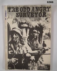
Administrative record - Army Survey Regiment Regimental Training 1984 - The Odd Angry Surveyor, Army Survey Regiment, Bendigo, 21 Feb 1984
... Surveyor" during the period 30 Apr - 12 May 1984. The Exercise conducted in two phases, Phase One- being theory lessons in a number of aspects of Infantry Minor Tactics at Section Level, whilst Phase Two- was putting into practice the lessons from Phase One....Surveyor" during the period 30 Apr - 12 May 1984. The Exercise conducted in two phases, Phase One- being theory lessons in a number of aspects of Infantry Minor Tactics at Section Level, whilst Phase Two- was putting into practice the lessons from Phase One. ...This is an Administrative Instruction setting out all aspects of the Army Survey Regiment Regimental Training Exercise "Odd Angry Surveyor" during the period 30 Apr - 12 May 1984. The Exercise conducted in two phases, Phase One- being theory lessons in a number of aspects of Infantry Minor Tactics at Section Level, whilst Phase Two- was putting into practice the lessons from Phase One.Light carboard covered A4 paper report stapled on left hand sideroyal australian survey corps, rasvy, fortuna, army survey regiment, army svy regt, asr -
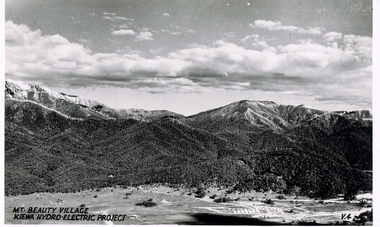
 Kiewa Valley Historical Society
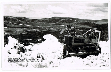
Postcard Circa 1950, Snow Plough, Bogong High Plain,5,500 Feet Kiewa Hydro-Electric Project, Circa 1950
... This influx to the regional population resulted in a corresponding diversity in services and brought about an environment that responded to a growing level of tourists and thereby permitting this industry to grow more rapidly than it would have naturally. This postcard details an attraction to the "cleaner" method of providing electricity. This postcard was purchased in 1950 by a surveyor ...This postcard was produced in the 1950's for the tourist trade in the Kiewa Valley and Alpine region. It encompasses the period when the State of Victoria was pressured by the ever increasing demand by industry and its population for electricity supplies. Hydro electricity was seen as an untapped natural resource to quench this demand. The Victorian Alps and the rivers flowing into its valleys was ideal for the construction of the Kiewa Hydro Electricity Scheme. The late 1940's saw the development of this scheme and the changing of sections of alpine landscape is covered by this and other postcards/pictures (tourists, construction workers, and established rural populations). This period in time was before the established wildlife and forest/nature groups became political activist who changed legislative acts to protect the environment. This rural region (Kiewa Valley/alpine plains) was at most only significant to a smaller group of winter sports, summer hikers/horse riders and rural farmers/graziers. The numbers of tourists and the increase in the local resident population was boosted by the construction of the Hydro Electricity Scheme. This influx to the regional population resulted in a corresponding diversity in services and brought about an environment that responded to a growing level of tourists and thereby permitting this industry to grow more rapidly than it would have naturally. This postcard details an attraction to the "cleaner" method of providing electricity. This postcard was purchased in 1950 by a surveyor at Landford's Gap. This item is a black and white photograph(professional) of a panoramic view of a snow plough clearing the unsealed road in 1950.This postcard is on quality paper and the reproduction of the picture is of a high standard.For other "tourist" postcards see 0480 (A) -(F) for other photos of similar postcards. kiewa valley tourism, victorian alps, alternate energy supplies, alpine population growth, secv, snow plough -
 Kiewa Valley Historical Society
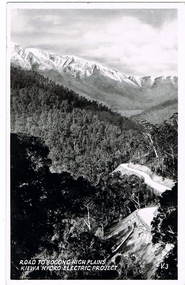
Postcard Circa 1950, Road to Bogong High Plains Kiewa Hydro Electric Project, Circa 1950's
... This influx to the regional population resulted in a corresponding diversity in services and brought about an environment that responded to a growing level of tourists and thereby permitting this industry to grow more rapidly than it would have naturally. This postcard details an attraction to the "cleaner" method of providing electricity. This postcard was purchased in 1950 by a surveyor ...This postcard was produced in the 1950's for the tourist trade in the Kiewa Valley and Alpine region. It encompasses the period when the State of Victoria was pressured by the ever increasing demand by industry and its population for electricity supplies. Hydro electricity was seen as an untapped natural resource to quench this demand. The Victorian Alps and the rivers flowing into its valleys was ideal for the construction of the Kiewa Hydro Electricity Scheme. The late 1940's saw the development of this scheme and the changing of sections of alpine landscape is covered by this and other postcards/pictures (tourists, construction workers, and established rural populations). This period in time was before the established wildlife and forest/nature groups became political activist who changed legislative acts to protect the environment.This rural region (Kiewa Valley/alpine plains) was at most only significant to a smaller group of winter sports, summer hikers/horse riders and rural farmers/graziers. The numbers of tourists and the increase in the local resident population was boosted by the construction of the Hydro Electricity Scheme. This influx to the regional population resulted in a corresponding diversity in services and brought about an environment that responded to a growing level of tourists and thereby permitting this industry to grow more rapidly than it would have naturally. This postcard details an attraction to the "cleaner" method of providing electricity. This postcard was purchased in 1950 by a surveyor at Landford's Gap.This black and white photograph on a Valentine's postcard is from a V2 Argus photograph.. It is on a 200g/m paper density photo side gloss. See 0480 (A) - (G) for other photos of similar postcards.In white lettering " ROAD TO BOGONG HIGH PLAINS KIEWA HYDRO-ELECTRIC PROJECT", V3secv, road making, victorian alps -
 Kiewa Valley Historical Society
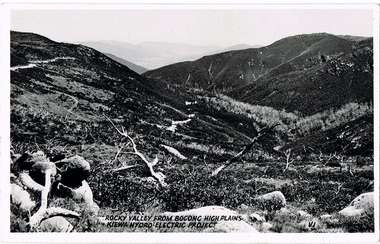
Postcard - Rocky Valley - Circa 1950, 1950
... This influx to the regional population resulted in a corresponding diversity in services and brought about an environment that responded to a growing level of tourists and thereby permitting this industry to grow more rapidly than it would have naturally. This postcard details an attraction to the "cleaner" method of providing electricity. This postcard was purchased in 1950 by a surveyor ...This postcard was produced in the 1950's for the tourist trade in the Kiewa Valley and Alpine region. It encompasses the period when the State of Victoria was pressured by the ever increasing demand by industry and its population for electricity supplies. Hydro electricity was seen as an untapped natural resource to quench this demand. The Victorian Alps and the rivers flowing into its valleys was ideal for the construction of the Kiewa Hydro Electricity Scheme. The late 1940's saw the development of this scheme and the changing of sections of alpine landscape is covered by this and other postcards/pictures (tourists, construction workers, and established rural populations). This period in time was before the established wildlife and forest/nature groups became political activist who changed legislative acts to protect the environment.This rural region (Kiewa Valley/alpine plains) was at most only significant to a smaller group of winter sports, summer hikers/horse riders and rural farmers/graziers. The numbers of tourists and the increase in the local resident population was boosted by the construction of the Hydro Electricity Scheme. This influx to the regional population resulted in a corresponding diversity in services and brought about an environment that responded to a growing level of tourists and thereby permitting this industry to grow more rapidly than it would have naturally. This postcard details an attraction to the "cleaner" method of providing electricity. This postcard was purchased in 1950 by a surveyor at Landford's Gap.This black and white photograph is from a Valentine's V2 Argus postcard. It is on a 200g/m paper density one side gloss. See also KVHS 0480 (A) to (L) for similar postcards. "ROCKY VALLEY FROM BOGONG HIGH PLAINS KIEWA HYDRO-ELECTRIC PROJECT" "V1"kiewa valley tourism, victorian alps, alternate energy supplies, alpine population growth, rocky valley, secv -
 Kiewa Valley Historical Society
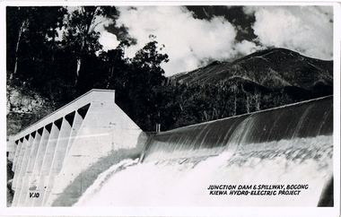
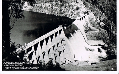
Postcard - Junction Dam - Circa 1950, Circa 1950's
... This influx to the regional population resulted in a corresponding diversity in services and brought about an environment that responded to a growing level of tourists and thereby permitting this industry to grow more rapidly than it would have naturally. This postcard details an attraction to the "cleaner" method of providing electricity. This postcard was purchased in 1950 by a surveyor ...This postcard was produced in the 1950's for the tourist trade in the Kiewa Valley and Alpine region. It encompasses the period when the State of Victoria was pressured by the ever increasing demand by industry and its population for electricity supplies. Hydro electricity was seen as an untapped natural resource to quench this demand. The Victorian Alps and the rivers flowing into its valleys was ideal for the construction of the Kiewa Hydro Electricity Scheme. The late 1940's saw the development of this scheme and the changing of sections of alpine landscape is covered by this and other postcards/pictures (tourists, construction workers, and established rural populations). This period in time was before the established wildlife and forest/nature groups became political activist who changed legislative acts to protect the environment.This rural region (Kiewa Valley/alpine plains) was at most only significant to a smaller group of winter sports, summer hikers/horse riders and rural farmers/graziers. The numbers of tourists and the increase in the local resident population was boosted by the construction of the Hydro Electricity Scheme. This influx to the regional population resulted in a corresponding diversity in services and brought about an environment that responded to a growing level of tourists and thereby permitting this industry to grow more rapidly than it would have naturally. This postcard details an attraction to the "cleaner" method of providing electricity. This postcard was purchased in 1950 by a surveyor at Landford's Gap.This black and white photograph is a Valentine's postcard, from a V2 Argus photograph. It is on a 200g/m paper density with only the photo side gloss.Front "JUNCTION DAM & SPILLWAY, BOGONG KIEWA HYDRO-ELECTRIC PROJECT" on the flip side "VALENTINE'S POST CARD " "A GENUINE PHOTOGRAPH"kiewa valley tourism, victorian alps, alternate energy supplies, alpine population growth, junction dam, secv -
 Kiewa Valley Historical Society
Postcard - Junction Dam - Circa 1950, Circa 1950
... This influx to the regional population resulted in a corresponding diversity in services and brought about an environment that responded to a growing level of tourists and thereby permitting this industry to grow more rapidly than it would have naturally. This postcard details an attraction to the "cleaner" method of providing electricity. This postcard was purchased in 1950 by a surveyor ...This postcard was produced in the 1950's for the tourist trade in the Kiewa Valley and Alpine region. It encompasses the period when the State of Victoria was pressured by the ever increasing demand by industry and its population for electricity supplies. Hydro electricity was seen as an untapped natural resource to quench this demand. The Victorian Alps and the rivers flowing into its valleys was ideal for the construction of the Kiewa Hydro Electricity Scheme. The late 1940's saw the development of this scheme and the changing of sections of alpine landscape is covered by this and other postcards/pictures (tourists, construction workers, and established rural populations). This period in time was before the established wildlife and forest/nature groups became political activist who changed legislative acts to protect the environment.This rural region (Kiewa Valley/alpine plains) was at most only significant to a smaller group of winter sports, summer hikers/horse riders and rural farmers/graziers. The numbers of tourists and the increase in the local resident population was boosted by the construction of the Hydro Electricity Scheme. This influx to the regional population resulted in a corresponding diversity in services and brought about an environment that responded to a growing level of tourists and thereby permitting this industry to grow more rapidly than it would have naturally. This postcard details an attraction to the "cleaner" method of providing electricity. This postcard was purchased in 1950 by a surveyor at Landford's Gap.This black and white photograph on a Valentine's postcard is from a V2 Argus photograph. It is on a 200g/m paper density one side gloss only/. See 0480 (A) -(L) for other photos of similar postcards."JUNCTION DAM & SPILLWAY, LAKE GUY, BOGONG, KIEWA HYDRO-ELECTRIC PROJECT" "V5" on the flip side" VALENTINE'S POST CARD " "A GENUINE PHOTOGRAPH"kiewa valley tourism, victorian alps, alternate energy supplies, alpine population growth, junction dam, secv -
 Kiewa Valley Historical Society
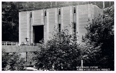
Postcard Circa 1950, No.3 Power Station Kiewa Hydro-electric Project "V.8", Circa 1950
... This influx to the regional population resulted in a corresponding diversity in services and brought about an environment that responded to a growing level of tourists and thereby permitting this industry to grow more rapidly than it would have naturally. This postcard details an attraction to the "cleaner" method of providing electricity. This postcard was purchased in 1950 by a surveyor ...This postcard was produced in the 1950's for the tourist trade in the Kiewa Valley and Alpine region. It encompasses the period when the State of Victoria was pressured by the ever increasing demand by industry and its population for electricity supplies. Hydro electricity was seen as an untapped natural resource to quench this demand. The Victorian Alps and the rivers flowing into its valleys was ideal for the construction of the Kiewa Hydro Electricity Scheme. The late 1940's saw the development of this scheme and the changing of sections of alpine landscape is covered by this and other postcards/pictures (tourists, construction workers, and established rural populations). This period in time was before the established wildlife and forest/nature groups became political activist who changed legislative acts to protect the environment.This rural region (Kiewa Valley/alpine plains) was at most only significant to a smaller group of winter sports, summer hikers/horse riders and rural farmers/graziers. The numbers of tourists and the increase in the local resident population was boosted by the construction of the Hydro Electricity Scheme. This influx to the regional population resulted in a corresponding diversity in services and brought about an environment that responded to a growing level of tourists and thereby permitting this industry to grow more rapidly than it would have naturally. This postcard details an attraction to the "cleaner" method of providing electricity. This postcard was purchased in 1950 by a surveyor at Landford's Gap.This black and white photograph from a Valentine's postcard is from a V2 Argus photograph postcard. It is on a 200g/m paper density photo side gloss. See 0480 (A) - (K) for other photos of similar postcards."No.3 POWER STATION KIEWA HYDRO ELECTRIC PROJECT" "V8"kiewa valley tourism, victorian alps, alternate energy supplies, alpine population growth, secv -
 Bendigo Military Museum
Photograph - Royal Australian Survey Corps Survey Observation Towers, c1950s
... surveyors setting up observation towers in the field and undertaking survey observations during mapping and geodetic control operations. c1950s. Survey observation towers were used mainly to take angular measurements in flat or heavily forested terrain, where height was necessary to achieve observer’s line-of-sight between field survey station. The Bilby Tower seen in photo .5P was erected to a height of 75 feet (23m) above ground level...surveyors setting up observation towers in the field and undertaking survey observations during mapping and geodetic control operations. c1950s. Survey observation towers were used mainly to take angular measurements in flat or heavily forested terrain, where height was necessary to achieve observer’s line-of-sight between field survey station. The Bilby Tower seen in photo .5P was erected to a height of 75 feet (23m) above ground level ...This is a set of seven photographs of Royal Australian Survey Corps surveyors setting up observation towers in the field and undertaking survey observations during mapping and geodetic control operations. c1950s. Survey observation towers were used mainly to take angular measurements in flat or heavily forested terrain, where height was necessary to achieve observer’s line-of-sight between field survey station. The Bilby Tower seen in photo .5P was erected to a height of 75 feet (23m) above ground level. The use of the Bilby Tower in Topographic Squadron’s field survey operations from 1955 to 1966 is described in page 54 of Valerie Lovejoy’s book 'Mapmakers of Fortuna – A history of the Army Survey Regiment’ ISBN: 0-646-42120-4. CAPT George Ricketts’ period of service was from 1942 to 1976 reaching the rank of LTCOL. It is noted in page 35 of Valerie Lovejoy’s book that then SGT Ricketts hand lettering skills came to the fore from his contribution to the draughting of one of the Japan’s Instruments of Surrender in 1945.This is a set of seven photographs of Royal Australian Survey Corps surveyors setting up observation towers in the field and undertaking survey observations during mapping and geodetic control operations. c1950s. The photographs were printed on photographic paper and are part of the Army Survey Regiment’s Collection. The photographs were scanned at 300 dpi. .1) - Photo, black & white, c1950s, ‘Bilby’ survey observation tower. .2) - Photo, black & white, c1950s, CAPT George Ricketts climbing ‘Bilby’ survey observation tower. .3) - Photo, black & white, c1950s, geodetic survey equipment on ‘Bilby’ survey observation tower. .4) - Photo, black & white, c1950s, two unidentified field surveyors on ‘Bilby’ survey observation tower. .5) - Photo, black & white, c1950s, two unidentified field surveyors, with CAPT Ricketts climbing ‘Bilby’ survey observation tower. .6) - Photo, black & white, c1950s, two unidentified field surveyors undertaking observations on survey observation tower. .7) - Photo, black & white, c1950, two unidentified field surveyors erecting or dismantling a survey observation tower..1P with paper tag annotated ‘Bilby Tower’ .4P on back – ‘Bilby Tower’. .5P on back – ‘Survey Observing Tower. Observing tower used for angular measurement in flat country. 75’ high – CAPT Ricketts climbing. .6P, .7P on back. ‘1960s?’royal australian survey corps, rasvy, army survey regiment, army svy regt, fortuna, asr, surveying -
 Kiewa Valley Historical Society
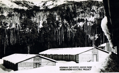
Postcard Circa 1950, Howman Gap Hostel under snow Kiewa Hydro-Electric Project, Circa 1950
... This influx to the regional population resulted in a corresponding diversity in services and brought about an environment that responded to a growing level of tourists and thereby permitting this industry to grow more rapidly than it would have naturally. This postcard details an attraction to the "cleaner" method of providing electricity. This postcard was purchased in 1950 by a surveyor ...This postcard was produced in the 1950's for the tourist trade in the Kiewa Valley and Alpine region. It encompasses the period when the State of Victoria was pressured by the ever increasing demand by industry and its population for electricity supplies. Hydro electricity was seen as an untapped natural resource to quench this demand. The Victorian Alps and the rivers flowing into its valleys was ideal for the construction of the Kiewa Hydro Electricity Scheme. The late 1940's saw the development of this scheme and the changing of sections of alpine landscape is covered by this and other postcards/pictures (tourists, construction workers, and established rural populations). This period in time was before the established wildlife and forest/nature groups became political activist who changed legislative acts to protect the environment.This rural region (Kiewa Valley/alpine plains) was at most only significant to a smaller group of winter sports, summer hikers/horse riders and rural farmers/graziers. The numbers of tourists and the increase in the local resident population was boosted by the construction of the Hydro Electricity Scheme. This influx to the regional population resulted in a corresponding diversity in services and brought about an environment that responded to a growing level of tourists and thereby permitting this industry to grow more rapidly than it would have naturally. This postcard details an attraction to the "cleaner" method of providing electricity. This postcard was purchased in 1950 by a surveyor at Landford's Gap.This item is a scanned black and white photograph of a panoramic view of Howman Gap Hostel under snow in 1950 (a closed village, entry by pass only). This accommodation was for construction workers only. See 0480 (A) -(E) for other photos of similar postcards.On the photo, " Howman Gap Hostel under snow Kiewa Hydro-Electric Project" . On postcard address and personal information side "V.2 Valentine's Post Card "kiewa valley tourism, victorian alps, alternate energy supplies, alpine population growth, bogong, secv, howman's gap hostel -
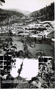 Kiewa Valley Historical Society
Postcard Circa 1950, Lake Guy Dam and Bogong Village, Circa 1950
... This influx to the regional population resulted in a corresponding diversity in services and brought about an environment that responded to a growing level of tourists and thereby permitting this industry to grow more rapidly than it would have naturally. This postcard details an attraction to the "cleaner" method of providing electricity. This postcard was purchased in 1950 by a surveyor ...This postcard was produced in the 1950's for the tourist trade in the Kiewa Valley and Alpine region. It encompasses the period when the State of Victoria was pressured by the ever increasing demand by industry and its population for electricity supplies. Hydro electricity was seen as an untapped natural resource to quench this demand. The Victorian Alps and the rivers flowing into its valleys was ideal for the construction of the Kiewa Hydro Electricity Scheme. The late 1940's saw the development of this scheme and the changing of sections of alpine landscape is covered by this and other postcards/pictures (tourists, construction workers, and established rural populations). This period in time was before the established wildlife and forest/nature groups became political activist who changed legislative acts to protect the environment.This rural region (Kiewa Valley/alpine plains) was at most only significant to a smaller group of winter sports, summer hikers/horse riders and rural farmers/graziers. The numbers of tourists and the increase in the local resident population was boosted by the construction of the Hydro Electricity Scheme. This influx to the regional population resulted in a corresponding diversity in services and brought about an environment that responded to a growing level of tourists and thereby permitting this industry to grow more rapidly than it would have naturally. This postcard details an attraction to the "cleaner" method of providing electricity. This postcard was purchased in 1950 by a surveyor at Landford's Gap.This black and white photograph from a Valentine's postcard is from a V2 Argus photograph postcard. It is on a 200g/m paper density photo side gloss. See 0480 (B) - (F) for other photos of similar postcards.In white lettering " LAKE GUY & BOGONG VILLAGE KIEWA HYDRO-ELECTRIC PROJECT"kiewa valley tourism, victorian alps, alternate energy supplies, alpine population growth -
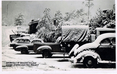 Kiewa Valley Historical Society
Postcard Circa 1950, Snowfall at Bogong Village Kiewa Hydro-Electric Project, 1950s
... This influx to the regional population resulted in a corresponding diversity in services and brought about an environment that responded to a growing level of tourists and thereby permitting this industry to grow more rapidly than it would have naturally. This postcard details an attraction to the "cleaner" method of providing electricity. This postcard was purchased in 1950 by a surveyor ...This postcard was produced in the 1950's for the tourist trade in the Kiewa Valley and Alpine region. It encompasses the period when the State of Victoria was pressured by the ever increasing demand by industry and its population for electricity supplies. Hydro electricity was seen as an untapped natural resource to quench this demand. The Victorian Alps and the rivers flowing into its valleys was ideal for the construction of the Kiewa Hydro Electricity Scheme. The late 1940's saw the development of this scheme and the changing of sections of alpine landscape is covered by this and other postcards/pictures (tourists, construction workers, and established rural populations). This period in time was before the established wildlife and forest/nature groups became political activist who changed legislative acts to protect the environment.This rural region (Kiewa Valley/alpine plains) was at most only significant to a smaller group of winter sports, summer hikers/horse riders and rural farmers/graziers. The numbers of tourists and the increase in the local resident population was boosted by the construction of the Hydro Electricity Scheme. This influx to the regional population resulted in a corresponding diversity in services and brought about an environment that responded to a growing level of tourists and thereby permitting this industry to grow more rapidly than it would have naturally. This postcard details an attraction to the "cleaner" method of providing electricity. This postcard was purchased in 1950 by a surveyor at Landford's Gap.This scanned black and white photograph of a postcard, shows vehicles covered in thick snow at Bogong Village in 1950. See 0480(A), (C) - (F) for other similar photos of postcards available at this period."SNOWFALL AT BOGONG VILLAGE KIEWA HYDRO-ELECTRICITY PROJECT"kiewa valley tourism, victorian alps, alternate energy supplies, alpine population growth, bogong village, secv -
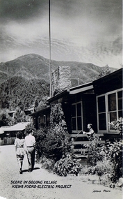 Kiewa Valley Historical Society
Postcard Circa 1950, Scene in Bogong Village Kiewa Hydro-Electric Project, 1950s
... This influx to the regional population resulted in a corresponding diversity in services and brought about an environment that responded to a growing level of tourists and thereby permitting this industry to grow more rapidly than it would have naturally. This postcard details an attraction to the "cleaner" method of providing electricity. This postcard was purchased in 1950 by a surveyor ...This postcard was produced in the 1950's for the tourist trade in the Kiewa Valley and Alpine region. It encompasses the period when the State of Victoria was pressured by the ever increasing demand by industry and its population for electricity supplies. Hydro electricity was seen as an untapped natural resource to quench this demand. The Victorian Alps and the rivers flowing into its valleys was ideal for the construction of the Kiewa Hydro Electricity Scheme. The late 1940's saw the development of this scheme and the changing of sections of alpine landscape is covered by this and other postcards/pictures (tourists, construction workers, and established rural populations). This period in time was before the established wildlife and forest/nature groups became political activist who changed legislative acts to protect the environment. This rural region (Kiewa Valley/alpine plains) was at most only significant to a smaller group of winter sports, summer hikers/horse riders and rural farmers/graziers. The numbers of tourists and the increase in the local resident population was boosted by the construction of the Hydro Electricity Scheme. This influx to the regional population resulted in a corresponding diversity in services and brought about an environment that responded to a growing level of tourists and thereby permitting this industry to grow more rapidly than it would have naturally. This postcard details an attraction to the "cleaner" method of providing electricity. This postcard was purchased in 1950 by a surveyor at Landford's Gap. The couple shown in this photograph would have been employed by the S.E.C. under the Kiewa Hydro-Electricity Scheme.This item is a scanned black and white photograph of a couple walking along a gravel street in Bogong Village in 1950. See 0480 (A) ,(B), (D) - (F) for other photos of similar postcards" SCENE IN BOGONG VILLAGE KIEWA HYDRO-ELECTRIC PROJECT"kiewa valley tourism, victorian alps, alternate energy supplies, alpine population growth, bogong, secv -
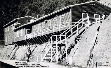 Kiewa Valley Historical Society
Postcard Circa 1950, Men's Mess No.4 Power Station, Kiewa Hydro-Electric Project
... This influx to the regional population resulted in a corresponding diversity in services and brought about an environment that responded to a growing level of tourists and thereby permitting this industry to grow more rapidly than it would have naturally. This postcard details an attraction to the "cleaner" method of providing electricity. This postcard was purchased in 1950 by a surveyor ...This postcard was produced in the 1950's for the tourist trade in the Kiewa Valley and Alpine region. It encompasses the period when the State of Victoria was pressured by the ever increasing demand by industry and its population for electricity supplies. Hydro electricity was seen as an untapped natural resource to quench this demand. The Victorian Alps and the rivers flowing into its valleys was ideal for the construction of the Kiewa Hydro Electricity Scheme. The late 1940's saw the development of this scheme and the changing of sections of alpine landscape is covered by this and other postcards/pictures (tourists, construction workers, and established rural populations). This period in time was before the established wildlife and forest/nature groups became political activist who changed legislative acts to protect the environment.Although this photo details the eating facilities of the construction workers at the power station it was not only a postcard for the people employed in the Hydro Scheme is was also provided to tourists visiting the area and thus used for promotional purposes.This rural region (Kiewa Valley/alpine plains) was at most only significant to a smaller group of winter sports, summer hikers/horse riders and rural farmers/graziers. The numbers of tourists and the increase in the local resident population was boosted by the construction of the Hydro Electricity Scheme. This influx to the regional population resulted in a corresponding diversity in services and brought about an environment that responded to a growing level of tourists and thereby permitting this industry to grow more rapidly than it would have naturally. This postcard details an attraction to the "cleaner" method of providing electricity. This postcard was purchased in 1950 by a surveyor at Landford's Gap. The men shown in this photograph would have been employed by the S.E.C. under the Kiewa Hydro-Electricity Scheme.This item is a scanned black and white photograph of a construction worker walking from stairs leading down from the men's mess building, in 1950. See 0480 (A) -(C), (E) - (F) for other photos of similar postcards"MEN'S MESS No.4 POWER STATION AREA, KIEWA HYDRO-ELECTRIC PROJECT" "ARGUS PHOTO V.IIkiewa valley tourism, victorian alps, alternate energy supplies, alpine population growth, secv -
 Kiewa Valley Historical Society
Postcard Circa 1950, Mt. Beauty Village, Kiewa Hydro-Electricity Project, circa 1950
... This influx to the regional population resulted in a corresponding diversity in services and brought about an environment that responded to a growing level of tourists and thereby permitting this industry to grow more rapidly than it would have naturally. This postcard details an attraction to the "cleaner" method of providing electricity. This postcard was purchased in 1950 by a surveyor ...This postcard was produced in the 1950's for the tourist trade in the Kiewa Valley and Alpine region. It encompasses the period when the State of Victoria was pressured by the ever increasing demand by industry and its population for electricity supplies. Hydro electricity was seen as an untapped natural resource to quench this demand. The Victorian Alps and the rivers flowing into its valleys was ideal for the construction of the Kiewa Hydro Electricity Scheme. The late 1940's saw the development of this scheme and the changing of sections of alpine landscape is covered by this and other postcards/pictures (tourists, construction workers, and established rural populations). This period in time was before the established wildlife and forest/nature groups became political activist who changed legislative acts to protect the environment. The regulatory pondage on the northern aspect of the village had no water over-spill from the unfinished power station.This rural region in 1950 (Kiewa Valley/alpine plains) was at most only significant to a smaller group of winter sports, summer hikers/horse riders and rural farmers/graziers. The numbers of tourists and the increase in the local resident population was boosted by the construction of the Hydro Electricity Scheme. This influx to the regional population resulted in a corresponding diversity in services and brought about an environment that responded to a growing level of tourists and thereby permitting this industry to grow more rapidly than it would have naturally. This postcard details an attraction to the "cleaner" method of providing electricity. This postcard was purchased in 1950 by a surveyor at Landford's Gap. The couple shown in this photograph would have been employed by the S.E.C. under the Kiewa Hydro-Electricity Scheme.This item is a scanned black and white photograph of a panoramic view of Mount Beauty Village in 1950 (a closed village, entry by pass only). The regulatory pondage has earthen walls but no water.See 0480 (A) -(D) and (F) for other photos of similar postcards"MT. BEAUTY VILLAGE KIEWA HYDRO-ELECTRIC PROJECT"kiewa valley tourism, victorian alps, alternate energy supplies, alpine population growth -
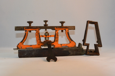 Kiewa Valley Historical Society
Sharpener Saw Raker/Jointer, early 1900s
... leveling platform on the bottom. The small size and weight of this saw sharpener was ideal for the travelling/mobile logger or surveyor(as in this case). ...surveyors "pack horses". Surveys during this period and in the dense mountainous terrain of the Victorian Alps was both exhausting and hazardous. Overnight accommodation at various log cabins was not always possible and swag/tent alternative was the "fall back" hand tool saw sharpening method tree felling. On one inner supports is stamped "DISSTON" and on the other "U.S.A." This raker/jointer saw sharpener was made in the USA (DISSTON) from cast and flat iron. The main body has been painted in orange. It has three adjustment screws on the top horizontal bar and one bolt on(adjusting) leveling ...This raker/jointer/guage set is a sharpening tool for cross cut logging saws. The logging saws used in the early 1900's for the clearing of forests required constant sharpening of their "cutting teeth". The logging of forested areas during these times was very much a "hands on" method of either one or two men by the use of saw or hand axe. Chain saws, chain and ball(clearing) and bulldozing methods came in the mid 1900's.This particular saw sharpening method was used by surveyors laying down boundaries for the S.E.C. Victoria Hydro Electricity Scheme (1920's). This item was given to a local Kiewa Valley lad who accompanied the initial surveyors. The lad was responsible for the tendering and feeding of the surveyors "pack horses". Surveys during this period and in the dense mountainous terrain of the Victorian Alps was both exhausting and hazardous. Overnight accommodation at various log cabins was not always possible and swag/tent alternative was the "fall back" This raker/jointer saw sharpener was made in the USA (DISSTON) from cast and flat iron. The main body has been painted in orange. It has three adjustment screws on the top horizontal bar and one bolt on(adjusting) leveling platform on the bottom. The small size and weight of this saw sharpener was ideal for the travelling/mobile logger or surveyor(as in this case). The main frame resembles two towers connected by two horizontal bars and the top of the towers has a horizontal bar with adjustment screws. See KVHS 0090 (B) for setting stake wedge adjusting the rake and cutting angle and KVHS 0090 (C) for a small spanner (for adjustments).On one inner supports is stamped "DISSTON" and on the other "U.S.A."hand tool, saw, sharpening method, tree felling. -
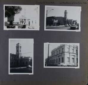 Glen Eira Historical Society
Album - Album page, Caulfield Town Hall cnr Hawthorn & Glen Eira Rds, Circa 1972
... surveyor, Sydney W. Smith is important in that the east elevation and facade (ground floor level only)as far west as the tower (lower two stages) survive as evidence of his work, the practice which his son continued after his death in 1886, becoming highly successful. ...This photograph is part of the Caulfield Historical Album 1972. This album was created in approximately 1972 as part of a project by the Caulfield Historical Society to assist in identifying buildings worthy of preservation. The album is related to a Survey the Caulfield Historical Society developed in collaboration with the National Trust of Australia (Victoria) and Caulfield City Council to identify historic buildings within the City of Caulfield that warranted the protection of a National Trust Classification. Principal photographer thought to be Trevor Hart, member of Caulfield Historical Society. Most photographs were taken between 1966-1972 with a small number of photographs being older and from unknown sources. All photographs are black and white except where stated, with 386 photographs over 198 pages. Caulfield Town Hall is now known as Glen Eira Town Hall.From Victorian Heritage Database: Citation for Town Hall, Corner Glen Eira and Hawthorn Roads - HO106 https://vhd.heritagecouncil.vic.gov.au/places/43613 as at (19/10/2020) The former City of Caulfield (now City of Glen Eira) Municipal Offices, located at the south-west corner of Hawthorn and Glen Eira Roads, Caulfield South, were commenced for the Borough of Caulfield in 1884 when they also included a Post and Telegraph Office and Court of Petty Sessions. They were designed by the Borough surveyor, Sydney Smith. The hall was completed in 1890 to the design of Alexander Rankin and the present hall, foyer and portico completed to the design of Goldsmith and Jenkin, architects, in 1931. The complex is historically, aesthetically and socially significant. It is historically significant {Criterion A) as the centre of Local Government services in the area since 1885 and as a centre of post and telegraph and legal services for a period. Its association with architect and Borough surveyor, Sydney W. Smith is important in that the east elevation and facade (ground floor level only)as far west as the tower (lower two stages) survive as evidence of his work, the practice which his son continued after his death in 1886, becoming highly successful. The work of Goldsmith and Jenkin is historically important in that it indirectly demonstrates the growth of the City sustained during the Inter-war period, the work proceeding in spite of the Depression. It compares with other similar work of that time including the refurbishment of the Malvern Municipal Offices and Hall in 1927 (Hudson and Wardrop), the Melbourne Corporation Offices and Hall in 1925-28 (Stephenson and Meldrum, A. and K. Henderson) and the Camberwell Offices and Council Chamber in 1924 (Leighton Irwin and Roy Stevenson), other comparable municipal projects being undertaken during the 1930s. Finally, the Goldsmith and Jenkin works are important as a project of the Depression years organised specifically to alleviate unemployment problems in the Municipality. The complex is aesthetically important (Criterion E) as a prominent and imposing Classically derived complex of its type with individually noteworthy interior spaces being the entry hall and staircase, main Hall, Foyer and Council Chamber. The Adamesque plasterwork, timber panelling and furniture, Art Nouveaux enrichment and Classically derived treatment with sparing use of Australian decorative motifs are contributory elements. Exterior .elements of note include the remains of the original design prepared by Sydney Smith and the clock tower and portico which have come to symbolise important Municipal complexes erected prior to the Second World War. The complex is socially important (Criterion G) for the value placed on it by the community which has made use of it for activities including that of Local government for well over a century.Page 74 of Photograph Album with four photographs (three portrait and one landscape) of different views of the Caulfield Town Hall.Hand written: Caulfield Town Hall cnr Hawthorn & Glen Eira Rds [top right] / 74 [bottom right] trevor hart, caulfield, glen eira, caulfield town hall, sydney smith, sydney w smith, municipal, adamesque plasterwork, adamesque, art nouveaux, portico, council chambers, alexander rankin, foyer, local government, timber panelling, tower, unemployment, clock tower, hawthorn road, glen eira road, city of glen eira, municipal offices, post and telegraph office, goldsmith and jenkin, courthouses, surveyors, architects, classical architectural style, streetscapes, gardens, cars, glen eira town hall, depression 1929-1939 -
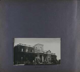 Glen Eira Historical Society
Album - Album page, Caulfield Town Hall cnr Hawthorn & Glen Eira Rds, Circa 1972
... surveyor, Sydney W. Smith is important in that the east elevation and facade (ground floor level only)as far west as the tower (lower two stages) survive as evidence of his work, the practice which his son continued after his death in 1886, becoming highly successful. ...This photograph is part of the Caulfield Historical Album 1972 but is noted as taken in 1922. This album was created in approximately 1972 as part of a project by the Caulfield Historical Society to assist in identifying buildings worthy of preservation. The album is related to a Survey the Caulfield Historical Society developed in collaboration with the National Trust of Australia (Victoria) and Caulfield City Council to identify historic buildings within the City of Caulfield that warranted the protection of a National Trust Classification. Principal photographer thought to be Trevor Hart, member of Caulfield Historical Society. Most photographs were taken between 1966-1972 with a small number of photographs being older and from unknown sources. All photographs are black and white except where stated, with 386 photographs over 198 pages. Caulfield Town Hall is now known as Glen Eira Town Hall.From Victorian Heritage Database: Citation for Town Hall, Corner Glen Eira and Hawthorn Roads - HO106 https://vhd.heritagecouncil.vic.gov.au/places/43613 as at (19/10/2020) The former City of Caulfield (now City of Glen Eira) Municipal Offices, located at the south-west corner of Hawthorn and Glen Eira Roads, Caulfield South, were commenced for the Borough of Caulfield in 1884 when they also included a Post and Telegraph Office and Court of Petty Sessions. They were designed by the Borough surveyor, Sydney Smith. The hall was completed in 1890 to the design of Alexander Rankin and the present hall, foyer and portico completed to the design of Goldsmith and Jenkin, architects, in 1931. The complex is historically, aesthetically and socially significant. It is historically significant {Criterion A) as the centre of Local Government services in the area since 1885 and as a centre of post and telegraph and legal services for a period. Its association with architect and Borough surveyor, Sydney W. Smith is important in that the east elevation and facade (ground floor level only)as far west as the tower (lower two stages) survive as evidence of his work, the practice which his son continued after his death in 1886, becoming highly successful. The work of Goldsmith and Jenkin is historically important in that it indirectly demonstrates the growth of the City sustained during the Inter-war period, the work proceeding in spite of the Depression. It compares with other similar work of that time including the refurbishment of the Malvern Municipal Offices and Hall in 1927 (Hudson and Wardrop), the Melbourne Corporation Offices and Hall in 1925-28 (Stephenson and Meldrum, A. and K. Henderson) and the Camberwell Offices and Council Chamber in 1924 (Leighton Irwin and Roy Stevenson), other comparable municipal projects being undertaken during the 1930s. Finally, the Goldsmith and Jenkin works are important as a project of the Depression years organised specifically to alleviate unemployment problems in the Municipality. The complex is aesthetically important (Criterion E) as a prominent and imposing Classically derived complex of its type with individually noteworthy interior spaces being the entry hall and staircase, main Hall, Foyer and Council Chamber. The Adamesque plasterwork, timber panelling and furniture, Art Nouveaux enrichment and Classically derived treatment with sparing use of Australian decorative motifs are contributory elements. Exterior .elements of note include the remains of the original design prepared by Sydney Smith and the clock tower and portico which have come to symbolise important Municipal complexes erected prior to the Second World War. The complex is socially important (Criterion G) for the value placed on it by the community which has made use of it for activities including that of Local government for well over a century.Page 75 of Photograph Album with one portrait photograph of the exterior of Caulfield Town Hall taken in 1922.Hand written: FEBRUARY 1922 [under photo] / 75 [bottom left] trevor hart, caulfield, glen eira, caulfield town hall, sydney smith, sydney w smith, adamesque plasterwork, art nouveaux, portico, council chambers, alexander rankin, foyer, local government, timber panelling, tower, unemployment, clock tower, hawthorn road, glen eira road, city of glen eira, municipal offices, palms, gardens, post and telegraph offices, goldsmith and jenkin, architects, city of caulfield, ivy clad walls, surveyors, depression 1929-1939, glen eira town hall -
 Stratford and District Historical Society
Theodolite
... SURVEYORS INSTRUMENTS "Troughton and Simm's/London" in fine engraving on upper plate. This theodoite consists of a bottom plate, which is damaged and has melted metal. This rises to a ball joint, on which is pivoted another plate on which were housed four screws, of which three remain, to adjust the level. ...This theodolite was used by `Mr Dawson' (presumably William Tennant Dawson c.1820-1873) who `surveyed much of the area around and beyond Stratford'. It was damaged by the fire which burnt the original Roseneath home in 1921, when the Macleods were in residence. (Mrs W.T. Dawson was a Macleod). One little boy aged 3 years was given the job of saving everything on the kitchen table when the fire started at breakfast time. The theodolite was possibly in use by Dawson when he laid out St Kilda Road.This theodoite consists of a bottom plate, which is damaged and has melted metal. This rises to a ball joint, on which is pivoted another plate on which were housed four screws, of which three remain, to adjust the level. Above this is another plate, with compass markings and melted glass."Troughton and Simm's/London" in fine engraving on upper plate.surveyors, instruments -
 Bendigo Historical Society Inc.
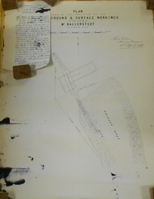
Document - MARKS COLLECTION: PLAN RELATING TO UNDERGROUND AND SURFACE WORKINGS VICTORIA HILL
... Surveyor, 22nd. April 1868' Attached to plan is a letter report accompanying plans on the underground workings in (illegible) Ballerstedt & Sons, Victoria Hill (ink blot covering writing RH side) Text of letter begins : the underground level southwards from the shaft is 4ft 6' x 6 ft wide as shown on the plan; and is at a depth of (illegible) from the surface; along the (illegible) of which the timbering both upright and cap-pieces; are now in as good condition as when the work was being proceed with; with the exception of the uprights and one cap-piece which are slightly crushed from the general settlement of the mullock. ...Surveyor, 22nd. April 1868' Attached to plan is a letter report accompanying plans on the underground workings in (illegible) Ballerstedt & Sons, Victoria Hill (ink blot covering writing RH side) Text of letter begins : the underground level southwards from the shaft is 4ft 6' x 6 ft wide as shown on the plan; and is at a depth of (illegible) from the surface; along the (illegible) of which the timbering both upright and cap-pieces; are now in as good condition as when the work was being proceed with; with the exception of the uprights and one cap-piece which are slightly crushed from the general settlement of the mullock. ...Plan on paper: on top of plan 'plan showing the position of the underground & surface workings in the claim of Mr. Ballerstedt Victoria Hill' Signed by Thomas Forbes, Mining Surveyor, 22nd. April 1868' Attached to plan is a letter report accompanying plans on the underground workings in (illegible) Ballerstedt & Sons, Victoria Hill (ink blot covering writing RH side) Text of letter begins : the underground level southwards from the shaft is 4ft 6' x 6 ft wide as shown on the plan; and is at a depth of (illegible) from the surface; along the (illegible) of which the timbering both upright and cap-pieces; are now in as good condition as when the work was being proceed with; with the exception of the uprights and one cap-piece which are slightly crushed from the general settlement of the mullock. The timbering of the drives is still standing in the same position though upwards of 12 months has elapsed after the slip in the open cutting had taken place, showing very clearly in my mind that the slip could not be attributable to the insufficient timbering of the underground workings; but rather to the action of the weather in this particular part of the cutting. The probably quantity of mullock that was detached or slipped from the west side of the cutting; would be (from careful enquiry and observation ) about 1500 loads at least; enough to crush the whole of the timber in the levels, if it had not been of the most substantial character and I think yours to prove that the fall was not caused by any defective timbering but from the cause already stated. I may state that I have inspected the underground workings generally in the mine, and the timbering is of the most substantial characterbendigo, mining, victoria hill -
 Bendigo Historical Society Inc.
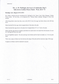
Document - MINING ACCIDENTS - MAN FALLS DOWN GOLDEN FLEECE SHAFT
... McHugh, Surveyor of Admiralty Dep't fell down the Golden Fleece Shaft on 28/5/73. The undergr'd Manager, Mr. Thomas Mann, was showing him around. They had been at the 300 ft level...McHugh, Surveyor of Admiralty Dep't fell down the Golden Fleece Shaft on 28/5/73. The undergr'd Manager, Mr. Thomas Mann, was showing him around. They had been at the 300 ft level ...Handwritten extract from the Bendigo Advertiser dated 29/5/1873. Mr. A. M. McHugh, Surveyor of Admiralty Dep't fell down the Golden Fleece Shaft on 28/5/73. The undergr'd Manager, Mr. Thomas Mann, was showing him around. They had been at the 300 ft level and the cage was below them. Mann knocked for the cage which stopped about four feet above the plat. Mann knocked the cage down, but it stopped about 10' or 12' above the plat. Mann said the cage had not stopped, and before he could remove his hand from the knocker, he saw Mr. McHugh fall down the shaft. He died. There was a space between the edge of the plat and innermost edge of the cage.document, gold, mining accidents, man falls down golden fleece shaft, mr a m mchugh, bendigo advertiser 29/5/1873, mr forbes, mr henry cook, mr thomas mann -
 Ringwood and District Historical Society
Map - Public Land Sale by Thomas Ham, 2000 Acres for Sale - Crown Sections 20, 23, 24 - Ringwood, Victoria - 1855
... Every lot is Staked and Trenched at the corners marked on the Plan thus - The Surveyor has carefully sub-divided the Property, in order to give every Farm a Creek for Water, Valley for Cultivation, and Hills for House and Grass Paddock. The ROADS have been very carefully laid out so as to give a firm, well drained, and nearly level road to each Homestead. ...Every lot is Staked and Trenched at the corners marked on the Plan thus - The Surveyor has carefully sub-divided the Property, in order to give every Farm a Creek for Water, Valley for Cultivation, and Hills for House and Grass Paddock. The ROADS have been very carefully laid out so as to give a firm, well drained, and nearly level road to each Homestead. ...Two 1850s surveyor's maps on cardboard backing showing area from Melbourne extending East beyond Bulleen and Nunawading. Detailed description of lots for sale and navigational directions to the property from Richmond by Thomas Ham, Victorian public servant, map maker, publisher, lithographer and original Ringwood land owner. Inset map enlarging area between Yarra River and Dandenong Creek, with southern boundary of allotments later forming part of Oban Road, North Ringwood.TRANSCRIPT: "This really valuable Property is now offered to the public for sale, in lots to suit purchasers at the Iow rate of £1 per Acre for 80 acres and upwards, and £1.10s per Acre for any smaller portion. Terms of payment Half Cash, Balance in 6 and 12 months, bearing 8 per cent interest. The Estate is well wooded with Gum, Cherry Tree and Stringy Bark, with Wattle in the valleys of the several creeks. Every lot is Staked and Trenched at the corners marked on the Plan thus - The Surveyor has carefully sub-divided the Property, in order to give every Farm a Creek for Water, Valley for Cultivation, and Hills for House and Grass Paddock. The ROADS have been very carefully laid out so as to give a firm, well drained, and nearly level road to each Homestead. Intending purchasers can readily find the property by the following directions, viz: Start from Richmond Bridge, at Hawthorne, then take the left-hand road to KEW. When at the "Woodman Inn", take the Cotham Road to the right, bearing due east, keep this Road, passing Trainor's "White Horse" Inn, and before you leave the fences, you will see calico bills (see margin) nailed to the Trees on the bush track leading to the Upper Yarra country, follow the Bills till you come to the SOUTH boundary line of the Property, which bears East and West (see Plan) where you will see Bills nailed up "THIS PROPERTY FOR SALE, etc." The Bills from Town lead direct to where Mr. Jull is erecting his Store, and arrangements have been made with him to show the lots to intending purchasers free of charge. At the respective corners of the lots the Bills are nailed up double, with numbers to denote the lot, and that the corner stake is adjacent. Any parties wishing to proceed to the property by way of BULLEEN will find Bills nailed on the Trees, commencing at the NEW INN, at "Wilson's Slip Rail." Keep this Track till you come to the Log Bridge, over the Deep Creek at Bloxhome's Paddock; go through the land now being cleared; keep the track over the hill till you come to an Iron House, you will then be on the property, which Iies to the North and East as per Plan. Follow the Bills till you come to Mr. Jull's Store, etc. etc. Further particulars can be had from the Agent for the Property. THOMAS HAM. " -
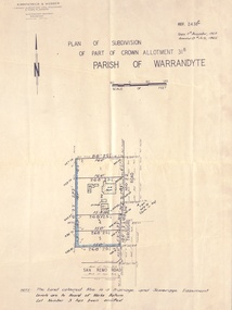 Ringwood and District Historical Society
Document - Plan of Subdivision, Part of Crown Allotment 31B, Parish of Warrandyte - 1965
... Surveyors, Civil Engineers & Town Planners, Maroondah Highway, Ringwood, Telephone 8700321. Ref 3438C. Date 4th December, 1964. Amended 19th July, 1965. Notation: "The land coloured blue is a drainage and sewerage easement. Levels...Surveyors, Civil Engineers & Town Planners, Maroondah Highway, Ringwood, Telephone 8700321. Ref 3438C. Date 4th December, 1964. Amended 19th July, 1965. Notation: "The land coloured blue is a drainage and sewerage easement. Levels ...Map showing residential allotments numbered 1, 2, 4 and 5, on Through Road, Ringwood, Vic., with property dimensions, including weatherboard house and galvanised iron garage on lot 2.Kirkpatrick & Webber, Licensed Surveyors, Civil Engineers & Town Planners, Maroondah Highway, Ringwood, Telephone 8700321. Ref 3438C. Date 4th December, 1964. Amended 19th July, 1965. Notation: "The land coloured blue is a drainage and sewerage easement. Levels are to Board of Works Datum. Lot number 3 has been omitted."