Showing 49 items matching "swamp creek"
-
 Lakes Entrance Historical Society
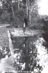
Photograph - Swamp Creek Buchan Road
... Swamp Creek Buchan Road...Swamp Creek Buchan Road...Boy on a bike standing by a waterhole Photograph Swamp Creek Buchan Road ...Black and white copy of a sepiaPostcard. Boy on a bike standing by a waterholeSwamp Creek Buchan Road -
 Federation University Historical Collection
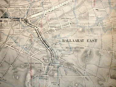
Map, Ballaarat Gold Field, 1861, 21/10/1861
... ...swamp creek...In November 2004 the Central Highlands Regional Library presented a special edition of 200 copies of the 1861 map reproduced from a copy in their collection. ballarat map davidson robert brough-smyth fitzpatrick cowan yuille's swamp public garden reserve manure depot black hill ballarat east old post office hill pennyweight hill claytons hill golden point mining railway cricket ground swamp creek cemetery sludge reserve bakery hill gaelic church juvenile reformatory orphanage specimen hill eureka lead cattle yard hill dalton's flat chinese village poverty hill railway reserve little bendigo diggings pound reserve allied armies flour mill agricultural reserve marsh survey reserve survey corps white flat yarrowee yarrowee creek brache j. brache survey ballaarat gold field 1861 Compiled & Drawn from the Survey of Mining Surveyors Davidson, Fitzpatrick and Cowan & the Plans in the Surveyor General's Office by J. ...A party of surveyors camped by Yuille's Swamp (later Lake Wendouree) and surveyed the countryside for a map to be produced by the Geological Survey of Victoria. In November 2004 the Central Highlands Regional Library presented a special edition of 200 copies of the 1861 map reproduced from a copy in their collection. Original geological map of Ballarat showing property, waterways, mines, churches, schools, water races, and garden reserves. It was compiled and drawn from the surveys of Mining Surveyors Davidson, Fitzpatrick and Cowan.Compiled & Drawn from the Survey of Mining Surveyors Davidson, Fitzpatrick and Cowan & the Plans in the Surveyor General's Office by J. Brahe, 21st October 1861. R. Brough Smyth, Secretary for Mines. The Honourable J.B. Humffray, M.L.A. Commr of Mines.ballarat, map, davidson, robert brough-smyth, fitzpatrick, cowan, yuille's swamp, public garden reserve, manure depot, black hill, ballarat east, old post office hill, pennyweight hill, claytons hill, golden point, mining, railway, cricket ground, swamp creek, cemetery, sludge reserve, bakery hill, gaelic church, juvenile reformatory, orphanage, specimen hill, eureka lead, cattle yard hill, dalton's flat, chinese village, poverty hill, railway reserve, little bendigo diggings, pound reserve, allied armies, flour mill, agricultural reserve, marsh, survey reserve, survey corps, white flat, yarrowee, yarrowee creek, brache, j. brache, survey, ballaarat gold field 1861 -
 Marysville & District Historical Society
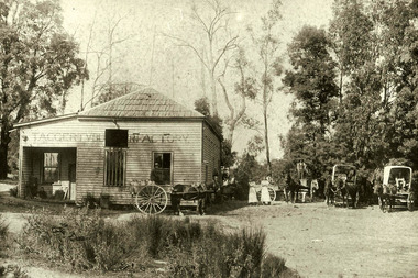
Photograph (Item) - Black and white photograph, 1904
... ...swamp creek road...The building no longer exists but materials from the original Taggerty Butter factory building now form part of the Williamson house off Swamp Creek Road. taggerty victoria taggerty butter factory little river kennedy family j b coombs acheron station thornton upper thornton alexandra dairy company williamson swamp creek road A black and white photograph of the Taggerty Butter Factory in Victoria. ...A black and white photograph of the Taggerty Butter Factory in Victoria.A black and white photograph of the Taggerty Butter Factory in Victoria taken around 1904. The Taggerty Butter factory opened in 1892 in the township on the Little River. It was run by the Kennedy family and built by J.B. Coombs of Acheron Station. Coombs was later Shire President. Milk had been previously taken daily to the steam-driven separators at Thornton. Upper Thornton. The cream was separated and the remains were taken back to the farms for the pigs and calves. Before these town separators existed butter had been made at home in a barrel, salted, and stored. The operation at Taggerty ceased in 1908 and the Alexandra Dairy Company took over production. The building no longer exists but materials from the original Taggerty Butter factory building now form part of the Williamson house off Swamp Creek Road.taggerty, victoria, taggerty butter factory, little river, kennedy family, j b coombs, acheron station, thornton, upper thornton, alexandra dairy company, williamson, swamp creek road -
 Ballarat Heritage Services
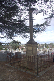
Photograph - Photograph - Colour, Burke and Wills Memorial at Bendigo Cemetery, 2018, 02/09/2018
... swamp...coopers creek...Died on his return at Coopers Creek, 30th June 1861. Charles Gray, died also on his return at Polygorum Swamp. 17th April 1861. ...These two trees are listed as Significant Trees by City of Greater Bendigo. bendigo cemetery burke and wills burke and wills memorial william john wills john o'hara burke charles gray polygonum swamp coopers creek Victorian Expedition carpentaria Bendigo Public Cemetery Bendigo Remembrance Park Thomas Pope Besnard Erected by the people of Bendigo in honor of the Victorian Explorers, Burke, Wills, Gray and King who first crossed the continent of Australia. ...Robert O'Hara Burke and Thomas Pope Besnard were childhood friends. As sexton of the local Back Creek Cemetery Thomas Besnard organised a subscription to raise the money for a monument to Burke, Wills and Gray. A subscription of one shilling, no more and not less, was asked so all subscribers were equal. The Bendigo monument was designed by Adam Duncan and features a Corinthian column mounted on a foundation stone, topped with a Grecian urn draped with the Union Jack. The stone for the monument was quarried from New Chum Mine. The site in the Bendigo Cemetery was selected by Besnard so the monument was on a grass knoll well clear of any other graves. The design included landscaping with a path and garden beds that provided dignified access. The Burke and Wills Monument in Bendigo has been entered on the Register of the National Estate as being important for its association with historical events and developments associated with exploration in the early days of Colony of Victoria. Two conifers remain from the original group sent by Mueller of the Melbourne Botanical Gardens to develop the garden layout on the knoll. These two trees are listed as Significant Trees by City of Greater Bendigo. The foundation block was laid on 20 August 1862 by Chairman of the Bendigo Municipality, Charles Burrows – exactly two years after the Expedition left Melbourne. A half day holiday was declared by Bendigo Council, and a procession left the Bendigo Town Hall and marched to the cemetery where 8000 people were gathered and another 4000 lined the route. John King was unable to attend due to ill health. Chairman of the Municipality of Bendigo, Charles Burrows, gave a long address, and diaries of members of the expedition, the Sandhurst Almanac, the Bendigo Advertiser, the Bendigo Independent Evening News, photographs of the deceased, photographs of Public Buildings in Bendigo, a Sydney half sovereign and all the silver coins of the Realm were wrapped in a Union Jack and placed in a niche in the foundation stone. Fifteen months later a column was erected on the foundation stone after Besnard openly criticised the Memorial Committee for their lack of action. The Bendigo Advertiser was disappointed at the location of the monument preferring a more central location and in 1893 an attempt was made to move the monument to Rosalind Park. On 19 May 1893, Mr Minto, the City Surveyor of the Bendigo MunicIpality reported it would cost £25, and no other action occurred. In 1940 the land around the memorial was sold off as grave sites and the paths and garden beds disappeared with graves now surrounding the base of the monument. The Burke and Wills Monument in Bendigo Cemetery was entered on the Register of the National Estate for its association with historical events and developments associated with exploration in the early days of Colony of Victoria. Two conifers remain from the original group sent by Mueller of the Melbourne Botanical Gardens to develop the garden layout on the knoll. These two trees are listed as Significant Trees by City of Greater Bendigo.Burke and Wills Memorial at Bendigo Cemetery, 2018Erected by the people of Bendigo in honor of the Victorian Explorers, Burke, Wills, Gray and King who first crossed the continent of Australia. King alone surviving the privation and suffering under which his three brave ill-fated companions sank. A.D. 1862. Robert O'Hara Burke, leader of the Victorian Expedition, left Melbounre 24th August 1860. Reached Carpentaria 12th Feby 1861. Died on his return at Coopers Creek, 30th June 1861. Charles Gray, died also on his return at Polygorum Swamp. 17th April 1861. William John Wills, second in command, died also near Coopers Creek, 29th June 1861. bendigo cemetery, burke and wills, burke and wills memorial, william john wills, john o'hara burke, charles gray, polygonum swamp, coopers creek, victorian expedition, carpentaria, bendigo public cemetery, bendigo remembrance park, thomas pope besnard -
 Warrnambool and District Historical Society Inc.
Map - Fire Maps, Region 5 Fire Control Map, 1963
... Places covered include Cavendish, Hamilton, Glen Thompson, Dunkeld, Hawkesdale, Warrnambool, Port Fairy and Peterborough and the maps show the type of roads, the swamps and creeks, rivers, railways, mountains and towns....Places covered include Cavendish, Hamilton, Glen Thompson, Dunkeld, Hawkesdale, Warrnambool, Port Fairy and Peterborough and the maps show the type of roads, the swamps and creeks, rivers, railways, mountains and towns. ...Two fire maps of south west Victoria.1 This is a rectangular piece of linen folded several times to form a packet with the front part covered with a brown card. The cover has a blue and white label. The map has a white base with red and green markings and red and black printing .2 As .1 abovenon-fictionTwo fire maps of south west Victoriafire maps, warrnambool history -
 Clunes Museum
Map, 1962
... FENTON. (2 COPIES) DETAILING SEALED ROADS, STATE FORESTS, PINE PLANTATIONS, FOREST AREAS, RAILWAYS, BOUNDARIES, TOWNSHIP AREAS CEMETERIES, CREEKS, SWAMPS AND HOUSES....FENTON. (2 COPIES) DETAILING SEALED ROADS, STATE FORESTS, PINE PLANTATIONS, FOREST AREAS, RAILWAYS, BOUNDARIES, TOWNSHIP AREAS CEMETERIES, CREEKS, SWAMPS AND HOUSES. Map MAP HEDGES & BELL PTY. ....1 &.2 MAP OF BALLARAT SHIRE GROUP RURAL FIRE BRIGADES FIRE CONTROL MAP. COMPILED BY C. H. FENTON. (2 COPIES) DETAILING SEALED ROADS, STATE FORESTS, PINE PLANTATIONS, FOREST AREAS, RAILWAYS, BOUNDARIES, TOWNSHIP AREAS CEMETERIES, CREEKS, SWAMPS AND HOUSES.local history, document, maps, fire brigade -
 Sunshine and District Historical Society Incorporated
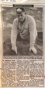
Article - Dinosaur Discovery By Des Johnson, The Advocate, 10th September 1997
... Sunshine resident, Des Johnson came across the fossilized imprint in a large rock at a swamp near the Kororoit Creek at Rockbank. Experts at the time of publication had not confirmed if the rock contains a genuine dinosaur imprint....Sunshine resident, Des Johnson came across the fossilized imprint in a large rock at a swamp near the Kororoit Creek at Rockbank. Experts at the time of publication had not confirmed if the rock contains a genuine dinosaur imprint. ...Sunshine resident, Des Johnson came across the fossilized imprint in a large rock at a swamp near the Kororoit Creek at Rockbank. Experts at the time of publication had not confirmed if the rock contains a genuine dinosaur imprint.Dinosaur Discoverydes johnson, dinosaur, kororoit creek, rockbank -
Federation University Historical Collection
Document, Articles on the Bunyip, 1983 - 1989
... The bunyip is a large mythical creature from Aboriginal mythology, said to lurk in swamps, billabongs, creeks, riverbeds, and waterholes. ...Barker Library (top floor) Mount Helen goldfields The bunyip is a large mythical creature from Aboriginal mythology, said to lurk in swamps, billabongs, creeks, riverbeds, and waterholes. ...The bunyip is a large mythical creature from Aboriginal mythology, said to lurk in swamps, billabongs, creeks, riverbeds, and waterholes. The origin of the word bunyip has been traced to the Wemba-Wemba or Wergaia language of Aboriginal people of South-Eastern Australia. However, the bunyip appears to have formed part of traditional Aboriginal beliefs and stories throughout Australia, although its name varied according to tribal nomenclature. Various written accounts of bunyips were made by Europeans in the early and mid-19th century, as settlement spread across the country. (http://en.wikipedia.org/wiki/Bunyip) This material was collected and used for resarch purposes by David Waldron A number of articles on the Bunyip * The Nessie Mystery Solver by Roy Fraser (October 1983) * Developers meet match (Wagyl) (The Age, 06 Jan 1989) * Narrandera's bunyips burst into tourism's limelight by Melanie Sincock (wagga Advertiser, 18 November 1986) * Hunting the bunyip by M.A. Troyahn (Australiasian Post, 06 October 1883) * Beware the bunyip, you Moomba skiers by Edel Wignell (The Age, 05 March 1982) * The yarn that grew the bunyip legend (Australasian Post, 30 December 1971) australian animal folklore collections, bunyip, bunyipswagyl, shane picket, narrandera, swan river, david waldron -
 Federation University Historical Collection
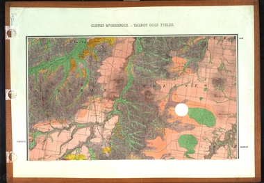
Map, Clunes, Mt Greenock, and Talbot Gold Fields, 1883, 1883
... A geological plan of the Clunes, Mt Greenock, and Talbot Gold Fields in two parts. .1) This section of the map includes Talbot, Talbot water supply race, Mt Glasgow, Little Green Hill, Middle Hill, Mt Cameron, Ballarat Hill, Bakery Hill, Goodwoman Hill, Scandanavian Lead, Eglinton Swamp, McCallum's Creek, Tullaroop Creek, Dunach, Maryborough Railway, Middle Creek and includes many mines such as Rip Van Winkel, Union Extended, South Greenock, Nicholl's Freehold. .2) This section of the map includes McCallums, Clunes, Green Hill, Mt Beckworth, Mt Gap, Maryborough Reservoir, and includes mines such as Lothair, Bute, Clyde, Clunes Consols, London and Australian, Oriental,...Barker Library (top floor) Mount Helen goldfields clunes talbot water supply railway geology A geological plan of the Clunes, Mt Greenock, and Talbot Gold Fields in two parts. .1) This section of the map includes Talbot, Talbot water supply race, Mt Glasgow, Little Green Hill, Middle Hill, Mt Cameron, Ballarat Hill, Bakery Hill, Goodwoman Hill, Scandanavian Lead, Eglinton Swamp, McCallum's Creek, Tullaroop Creek, Dunach, Maryborough Railway, Middle Creek and includes many mines such as Rip Van Winkel, Union Extended, South Greenock, Nicholl's Freehold. .2) This section of the map includes McCallums, Clunes, Green Hill, Mt Beckworth, Mt Gap, Maryborough Reservoir, and includes mines such as Lothair, Bute, Clyde, Clunes Consols, London and Australian, Oriental, Clunes, Mt Greenock, and Talbot Gold Fields, 1883 Map Map J. ...A geological plan of the Clunes, Mt Greenock, and Talbot Gold Fields in two parts. .1) This section of the map includes Talbot, Talbot water supply race, Mt Glasgow, Little Green Hill, Middle Hill, Mt Cameron, Ballarat Hill, Bakery Hill, Goodwoman Hill, Scandanavian Lead, Eglinton Swamp, McCallum's Creek, Tullaroop Creek, Dunach, Maryborough Railway, Middle Creek and includes many mines such as Rip Van Winkel, Union Extended, South Greenock, Nicholl's Freehold. .2) This section of the map includes McCallums, Clunes, Green Hill, Mt Beckworth, Mt Gap, Maryborough Reservoir, and includes mines such as Lothair, Bute, Clyde, Clunes Consols, London and Australian, Oriental,clunes, talbot, water supply, railway, geology -
 Eltham District Historical Society Inc
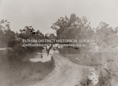
Photograph, Diamond Creek in flood over Glen Park Bridge, Eltham, c. 26 August 1924
... Significant flooding of the Diamond Creek occurred in Eltham and Glen Park on Tuesday, August 26, 1924 with several houses swamped and all bridges covered except the Greensborough Road Bridge. ...Eltham District Historical Society Inc 728 Main Rd Eltham melbourne Significant flooding of the Diamond Creek occurred in Eltham and Glen Park on Tuesday, August 26, 1924 with several houses swamped and all bridges covered except the Greensborough Road Bridge. ...Significant flooding of the Diamond Creek occurred in Eltham and Glen Park on Tuesday, August 26, 1924 with several houses swamped and all bridges covered except the Greensborough Road Bridge. [Houses at Eltham Flooded. (1924, August 27). The Argus (Melbourne, Vic. : 1848 - 1957), p. 19. Retrieved from http://nla.gov.au/nla.news-article4156891] The Glen Park Bridge was originally built as a replacement for an older private bridge built by a man named Foley around 1880. In 1911 Heidelberg and Eltham agreed to share the costs to build a new bridge. Construction began in June 1915 and it was officially opened by Cr. Taylor on Cup Day, November 1915. The bridge was destroyed by floodwaters in the afternoon of 20 September 1959 during construction of the new Wattletree Road bridge. The new bridge west embankment joined the existing road at approximately where the bend in the road is situated in the photograph.Colour photograph of originalfloods, eltham, diamond creek (creek), egan's crossing, eltham-diamond creek road, glen park bridge, glen park road -
Glen Eira Historical Society
Document - BOX FAMILY
... Creek... Primitive Methodist Church... Lewis’ Timber Yard... Grape Growing... Paling House... Wells... Water Wagon... Market Gardens... Farming... Aboriginal People... King Billy... Chinese... Kayon (?)... Kay You (Yu?)... Cheong Ki... Boxer Rebellion... Chinese Missionary... Brickmakers... Midwife... Corben’s Monumental Masons... Sculptor... Cottage... Parlour... Verandah... Scullery... Le Man’s Swamp...Robilliard George James Box Ester Box Fanny (Downard) Box Eleanor Philbrick Richard Fairlam Richard Hale Jasper Dendy Henry Renick Mark Renick Stefanie (nee Riemann) Brighton Cemetery Ormond East Brighton Prahran Centre Road Jasper Road Manchester Road McKinnon Road North Road Brighton Box Cottage Moorabbin Historical Society Thomas Street Elsternwick Paterson Road East Bentleigh Tucker Road Jasper Road Harwood Thomas Box Violet Hordeen Lebbens Augustus Arthur Wattle Pioneers Ancient Order of Foresters Council of Moorabin Elster Creek Primitive Methodist Church Lewis’ Timber Yard Grape Growing Paling House Wells Water Wagon Market Gardens Farming Aboriginal People King Billy Chinese Kayon (?) Kay You (Yu?) Cheong Ki Boxer Rebellion Chinese Missionary Brickmakers Midwife Corben’s Monumental Masons Sculptor Cottage Parlour Verandah Scullery Le Man’s Swamp Flower Nursery Chook Houses Ladies College Moorabbin Roads Board Western Market Eastern Market Victoria Market St. ...Extensively detailed family history from 1838 in UK to present day. Provides much local history and social history into early pioneering and market gardening families. Forty one page computer print out with numerous black and white photographs.box w.h. george, box george, box mary nee cripps, box caroline, box william, box henry, box john, box anna, box eliza, box elizabeth nee avis, box francis, box lydia, moeller a., mclean n., robilliard george james, box ester, box fanny (downard), box eleanor, philbrick richard, fairlam richard, hale jasper, dendy henry, renick mark, renick stefanie (nee riemann), brighton cemetery, ormond, east brighton, prahran, centre road, jasper road, manchester road, mckinnon road, north road, brighton, box cottage, moorabbin historical society, thomas street, elsternwick, paterson road, east bentleigh, tucker road, jasper road, harwood thomas, box violet, hordeen lebbens, augustus arthur, wattle, pioneers, ancient order of foresters, council of moorabin, elster creek, primitive methodist church, lewis’ timber yard, grape growing, paling house, wells, water wagon, market gardens, farming, aboriginal people, king billy, chinese, kayon (?), kay you (yu?), cheong ki, boxer rebellion, chinese missionary, brickmakers, midwife, corben’s monumental masons, sculptor, cottage, parlour, verandah, scullery, le man’s swamp, flower nursery, chook houses, ladies college, moorabbin roads board, western market, eastern market, victoria market, st. kilda road, nepean road/highway, mckinnon, ormond, carnegie, oakleigh, murrumbeena, moorabbin, mordialloc, heathcote, bentleigh, brighton east, manchester road, brighton council, city of moorabbin, west joseph, porter harriet, moore henry, moeller a (moller), box mary, lindsay mccurry elizabeth, lindsay elizabeth, lindsay henry, lindsay frederick, schmidt william, robilliard james cpt., beckett ida, beckett nellie, beckett martha, beckett martha maud, robinson eleanor, robinson joyce, dowling thomas, anderson william snowden, mccurry henry mr & mrs, box emily jane (nee mccurry), jorgensen justin, jorgensen dr., jorgenson bertha, ross william murray, st. kilda, merrie creek, pentridge (now coburg), murray road, wyuna dunoos st, grange road, rosstown, tucker rd, elizabeth st, common school no 213 east brighton, bentleigh, steel roads tracks, rabbits, cheltenham, brighton cemetery, cheltenham cemetery, paterson road, east boundary road, baptist church, lay preachers, missionaries- china, oakleigh tyre works, belfast hotel sandhurst (bendigo), mornington, gas street lighting, brighton historical society, moorabbin primary school, bravis road, lewis street, chalmers street, grange road, butcher shops, ormond state school, oakleigh council, wedding dress, methodist children’s home cheltenham, bentleigh baptist church, auctioneer, lindsay mark, balkham jane, balkham stephen, reitman august william, fitzwilliam catherine, quashdorf (?phonetic) mr, box violet, montford paul, reitman stephanie (renick mrs), reitman william, box ada, downard alicia (lill), downard arthur, downard edward, graham elizabeth, downard octavia rose, downard william alfred, downard arthur henry (harvey), downard fanny, thompson eliza jane, box lena caroline, viloudaki rebecca, box anna (pay), pay henry, box eliza (gurr), johnson geoffrey, rushall eleanor (nellie), gurr eliza nee box, gurr jabez henry tasman, marriot william mrs, ross william murray, box gladys (nee battersby), box dulcie (bussell), bussell samuel robert, bussell norma (hoult), bussell darren lyle, bussell craig andrew, bussell sylvia june (barry), barry j. haydon, barry rachael alexandra, barry phillipa anne, barry vanessa kate, bussell joan lorraine (millie), millie john, bussell harold leslie, euston mr, purdue edgar robert, box lydia elizabeth, wilkinson coral doreen, mitchell donald, centre road, court pride of st george aof, dunoon street, vickery street, darey street/ave., oakleigh state school, methodist church, mill street, koornang road, regent street, marriage road, box olivia christina, box ernest charles, box walter william, lawson robert, lawson nancy eunice (curtis), box walter stanley, box eleanor (nellie) rushall, box martha, box john, box nellie gladys, andrews william (bill), box ray, mccurry mrs elizabeth, box william henry george, schreiber family, jorgensen family, downward arthur, downward alicia – lill, downward octavia rose, downward william alfred, downward arthur henry/harvey, cummings ida, cummings william, downward alice (nee cleary), downward ada, downward lucy (mrs bailey), downward alice, downward arthur harvey, bailey lawrence, bailey ian, bailey carol viola (bartlett), bailey colin harvey, bailey julie alison (hardware), bailey val, bailey adina, bailey david, bartlett brian, bartlett bradley grant, bartlett clayton lawrence, hardware michael, hardware dion michael colin, hardware jevon michael bailey, box elanor, box alice amelia (dale), dale george, dale elizabeth, dale lilly, dale john, dale thomas, dale rose, dale ethelbert, dale george, dale elsie, box thomas henry, box annie lavinia (rogers), rogers annie elizabeth, rogers william richard, box arthur walter, nelson dagma marie (box), box walter kingston, box marie, box cecilia eliza (ainger), ainger james, box ida may, cumming william george, cumming wendy (nee mansell), cumming susan, cumming paul, cumming felicity (steel), cumming shane, cumming melissa, cumming angel, box harold, box dorothy may (jackson), jackson frederick, jackson margaret (walker), jackson judith, walker david, walker michelle (neville), neville andrew, walker darren, walker rebecca (coyne), walker joshua, walker bradley, johnson steven, johnson carl, johnson judith (jackson), johnson peter, johnson melissa (hamid), johnson craig, ely johnson/jackson judith, ely steven, linham arthur, box thelma elizabeth (eagle), eagle keith, eagle nancye elizabeth (harpin), harkin john, harkin mary anne (howe), howe barry, howe samuel, harkin michael, harkin christopher, harkin elizabeth, eagle roddan, eagle carolyn (mansell), eagle gerard, eagle kerri – lee, box avis ann (eldridge), eldridge alf, eldridge robert, eldridge sandra, eldridge adam, eldridge nicholas, eldridge patric, eldridge john, eldridge carol (biggs), eldridge robert james, eldridge catherine elizabeth, eldridge meredith, box william john, box maud (nee hanchette), box malcome, box sandra (ede), box stephen, box nicolle, box andrew, box christine (dormer), box corrina, box jennifer (turpin), turpin phillip, box herbert, box olwyn (richard), box elaine henry, henry bruce, henry james, henry robin, henry david, box richard, box nerida (bowen), box duncan, box john, box cerwiden, box ewan, box bryan, box collen (malony), box kieran, box eden, box christopher, box pam (smith), box sue (tirchett), box thomas, box william, box george frederick, box olive (cameron), box eliza jane (thompson), box francis george, box lena caroline, box-hembrow mable alma, box charles francis, clinch mr., box robinson jessie melinda, box clay edith florence, north brighton, waun alex, waun robert, marquis peter, sheppard w., warnbach mr, marriott william mrs, box dorothy (seabrook), box hazel, box jessie, box frank (francis), seabrook len, box henry, seabrook albert, seabrook stanley allan, barry j. haydon, barry rachel alexandra, millie john, bussell harold leslie, bussell sue, bussell leanne melinda, bussell benjamin leslie, bussell lynette, box george, box jean (holms), box george, box alisa (hughes), hughes justin, hughes ebony, hughes tasman, box robin, box veronica (roman), box andrea roman, box lisa roman, box jodi roman, box malcome, box sue (kerrison), box amanda, box anthony, clay john (jack) francis, clay lynda blanche (nee sibte), clay vivien, clay majory joy, lipman vernon (vern) ronald, clay kenneth graham, clay laura jean -
 Bendigo Historical Society Inc.
Document - HARRY BIGGS COLLECTION: BOORT CEMETERY
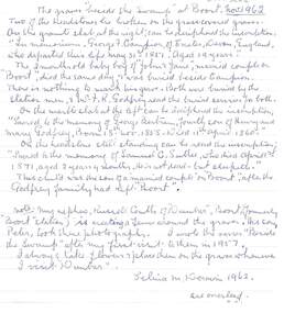
... Long gone are they who loved them best/The trees still whisper by the swamp; the night birds call, and vigil keep/As in those far-off yesterdays - where Campion and three children sleep........'Selina White Birth Date Abt 1882 Birth Place Serpentine Creek, Victoria Registration Year 1882 Registration Place Victoria, Australia Father John White Mother Aary Ann Nicholls Registration Number 25736 ...Long gone are they who loved them best/The trees still whisper by the swamp; the night birds call, and vigil keep/As in those far-off yesterdays - where Campion and three children sleep........'Selina White Birth Date Abt 1882 Birth Place Serpentine Creek, Victoria Registration Year 1882 Registration Place Victoria, Australia Father John White Mother Aary Ann Nicholls Registration Number 25736 MEMORIALS Graveboards Boort Cemetry Russell Coutts 'Dunbar' Peter Coutts George F. ...Selina Deravin (Born 1882, Serpentine Creek. Died 1968, Melbourne, age 85), father John White, mother Mary Ann Nicholls was married to Garnet Deravin, a medical doctor. In 1928, (Electoral Roll Bendigo) Garnet and Selina were living at 109 Queen Street, Bendigo; later at 13 Tuxon Street, North Balwyn, where Garnet died on 15th. April, 1954 (Argus, 17th April, 1954). Deravin family owned the Chateau Dore vineyard and winery. Selina published a book of her poetry. A poem ' Beside the Swamp' was written following her visit to the swamp at Boort: ' In silence by the graves I stood, of those who long had lain at rest/In lonely quiet, in the bush. Long gone are they who loved them best/The trees still whisper by the swamp; the night birds call, and vigil keep/As in those far-off yesterdays - where Campion and three children sleep........'Selina White Birth Date Abt 1882 Birth Place Serpentine Creek, Victoria Registration Year 1882 Registration Place Victoria, Australia Father John White Mother Aary Ann Nicholls Registration Number 25736 Hand written letter by Selina De Ravin, titled 'The graves beside the swamp at Boort.' dated November 1962. Two of the headstones lie broken on the grass covered graves. On the granite slab at the right is the inscription 'In memoriam. George F. Campion of Exeter Devon, England, who departed this life, May 31st 1851. Aged 19 years. The 2 month old baby boy of 'John and Jane', married couple on 'Boort', died the same day and was buried beside Campion. There is nothing to mark his grave. Both were buried by the Station men. Mr J. R. Godfrey read the burial services for both. On the marble slab at the left can be deciphered the inscription sacred to the memory of George Bertram, fourth son of Henry and Mary Godfrey, Born 18th November 1858. Died 11th April 1860. On the headstone still standing can be read the inscription Sacred to the memory of Samuel C. Sutlee, who died April 1st 1871, aged 2 years 4 months. He is not dead - but sleepeth. This child was the son of a married couple 'on Boort', after the Godfrey family had left 'Boort'. Note - My nephew Russell Coutts of 'Dunbar', Boort, (formerly 'Boort' Station) is erecting a fence around the graves. His son, Peter took these photographs. I wrote the verses 'Beside the Swamp' after my first visit to them in 1957. I always take flowers and place them on the graves whenever I visit 'Dunbar' Selina M. Deravin 1962Russell Coutts and his son Peter have restored the graves beside the Lake at 'Dunbar' and erected a graveyard. This photograph was taken by Peter and the flowers placed on the graves by his mother Wilma who helps to care for them. They also discovered a fifth unknown grave there when erecting the fence and re- erecting the broken and fallen headstones. S. M. Deravin. (Selina De Ravin) a. Typed poem on carbon copy flimsy paper: 'Beside the Swamp', signed in blue pen by Lina Deravin, January 1957'. Written on the bottom in blue pen: ' In February 1960 when on a visit to Boort I took some flowers and placed them on these graves beside the swamp'. Signed Lina Devarin.Selina M. Deravinmemorials, graveboards, boort cemetry, russell coutts, 'dunbar', peter coutts, george f. campion, boort cemetery, samuel c. sutlee?., poetry, poem, garnet deravin, selina deravin -
 Eltham District Historical Society Inc
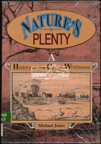
Book, Michael Jones, Nature's plenty : a history of the City of Whittlesea, 1992
... swamp management system' now buried under Yan Yean reservoir. Smallpox epidemics among Aboriginal people prior to settlement - probably from the activity of nearby European sealers. Estimations of Aboriginal populations. Scattered references throughout. Subjects Health - Infectious diseases - Smallpox. Settlement and contacts - Colonisation - 1788-1850. Settlement and contacts - Colonisation - 1851- Environment - Land management. Demography. Woiwurrung / Wurundjeri / Woiwurung people (S36) (Vic SJ55-05) Yan Yean (Vic SJ55-05) Eden Park (Vic SJ55-05) Whittlesea (Vic SJ55-05) Diamond Creek...swamp management system' now buried under Yan Yean reservoir. Smallpox epidemics among Aboriginal people prior to settlement - probably from the activity of nearby European sealers. Estimations of Aboriginal populations. Scattered references throughout. Subjects Health - Infectious diseases - Smallpox. Settlement and contacts - Colonisation - 1788-1850. Settlement and contacts - Colonisation - 1851- Environment - Land management. Demography. Woiwurrung / Wurundjeri / Woiwurung people (S36) (Vic SJ55-05) Yan Yean (Vic SJ55-05) Eden Park (Vic SJ55-05) Whittlesea (Vic SJ55-05) Diamond Creek ...This book explores Whittlesea's history from early 1830's to 1991. Environment of the Aboriginal people about the the time of European settlement. Possible use of a 'swamp management system' now buried under Yan Yean reservoir. Smallpox epidemics among Aboriginal people prior to settlement - probably from the activity of nearby European sealers. Estimations of Aboriginal populations. Scattered references throughout. Subjects Health - Infectious diseases - Smallpox. Settlement and contacts - Colonisation - 1788-1850. Settlement and contacts - Colonisation - 1851- Environment - Land management. Demography. Woiwurrung / Wurundjeri / Woiwurung people (S36) (Vic SJ55-05) Yan Yean (Vic SJ55-05) Eden Park (Vic SJ55-05) Whittlesea (Vic SJ55-05) Diamond Creek (Vic SJ55-05) Kingslake (Vic SJ55-05) Whittlesea (Vic.) -- History.xvi, 319 p., [16] p. of plates : ill. (some col.), maps (some col.), ports. ; 28 cm. the plenty, farming, settlement, gold rush, plenty river, donnybrook, germantown, separation, thomastown, whittlesea, epping, woodstock, city of whittlesea, railway, yan yean, roll of honour -
 Bendigo Historical Society Inc.
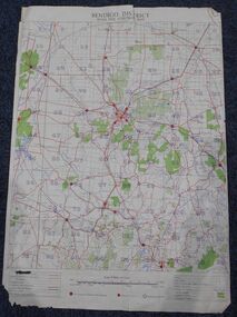
Map - Bush Fire Control Map Bendigo District
... creeks and water courses. Also marked are houses, Post Offices, Police stations, bush fire brigades, water channels, swamps, marshes, dense, medium and scattered timber, aqueducts and reservoirs. ...creeks and water courses. Also marked are houses, Post Offices, Police stations, bush fire brigades, water channels, swamps, marshes, dense, medium and scattered timber, aqueducts and reservoirs. ...A Bush Fire Control map is a valuable tool used by emergency services and communities to respond to respond to bushfires.Cream coloured parchment map showing roads, railway lines, telephone lines, rivers, creeks and water courses. Also marked are houses, Post Offices, Police stations, bush fire brigades, water channels, swamps, marshes, dense, medium and scattered timber, aqueducts and reservoirs. Villages, districts and Towns are clearly marked. Printed in red, green, black and blue. Very clear and easy to read. Undated.bush fires, bendigo area map -
 Bendigo Historical Society Inc.
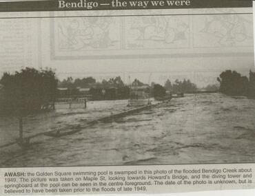
Newspaper - JENNY FOLEY COLLECTION: AWASH
... Awash: the Golden Square swimming pool is swamped in this photo of the flooded Bendigo Creek about 1949. The picture was taken on Maple St. looking towards Howard's Bridge, and the diving tower and springboard at the pool can be seen in the centre foreground. ...Awash: the Golden Square swimming pool is swamped in this photo of the flooded Bendigo Creek about 1949. The picture was taken on Maple St. looking towards Howard's Bridge, and the diving tower and springboard at the pool can be seen in the centre foreground. ...Bendigo Advertiser ''The way we were'' from 2000. Awash: the Golden Square swimming pool is swamped in this photo of the flooded Bendigo Creek about 1949. The picture was taken on Maple St. looking towards Howard's Bridge, and the diving tower and springboard at the pool can be seen in the centre foreground. The date of the photo is unknown, but is believed to have been taken prior to the floods of late 1949. The clip is in a folder.newspaper, bendigo advertiser, the way we were -
 Ringwood and District Historical Society
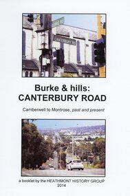
Book, Burke & Hills: Canterbury Road Camberwell to Montrose, by Heathmont History Group - 2014
... Grand homes and churches at one end, major and minor shopping centres along the 25km, factories now where farms were, big box stores, fast food outlets, train stations, resrvoir, traffic, residential stretches, modern apartment blocks, parklands, child-minding centres, sporting ovals, a sewage farm, hotels, quarries, commercial developments, plant nurseries, a golf course, bridges, memorials, Asian food shops, telecommunication towers, bushland, creeks, crossroads, traffic lights, mansions, orchards, swamps ... Delaneys Road, renamed Canterbury Road after a 19th century Victorian Governor, is a fascinating study in land use and history as suburban Melbourne has continually diversified and pushed outwards. ...Grand homes and churches at one end, major and minor shopping centres along the 25km, factories now where farms were, big box stores, fast food outlets, train stations, resrvoir, traffic, residential stretches, modern apartment blocks, parklands, child-minding centres, sporting ovals, a sewage farm, hotels, quarries, commercial developments, plant nurseries, a golf course, bridges, memorials, Asian food shops, telecommunication towers, bushland, creeks, crossroads, traffic lights, mansions, orchards, swamps ... Delaneys Road, renamed Canterbury Road after a 19th century Victorian Governor, is a fascinating study in land use and history as suburban Melbourne has continually diversified and pushed outwards. ...Soft cover book of 40 pages with spiral wire spine. Compilation of images and descriptive timeline of the geology, geography and European settlement history of Canterbury Road.Soon after beginning at Burke Road Camberwell, Canterbury Road moves into the gentle hills of Canterbury, then on to Surrey Hills, Box Hill and Forest Hill. Further along past these three "hills" come three "monts" - Vermont, Heathmont and at its other end, Montrose, by then in the foothills of the Dandenongs. Grand homes and churches at one end, major and minor shopping centres along the 25km, factories now where farms were, big box stores, fast food outlets, train stations, resrvoir, traffic, residential stretches, modern apartment blocks, parklands, child-minding centres, sporting ovals, a sewage farm, hotels, quarries, commercial developments, plant nurseries, a golf course, bridges, memorials, Asian food shops, telecommunication towers, bushland, creeks, crossroads, traffic lights, mansions, orchards, swamps ... Delaneys Road, renamed Canterbury Road after a 19th century Victorian Governor, is a fascinating study in land use and history as suburban Melbourne has continually diversified and pushed outwards. Compiled by Heathmont History Group, Rita James, Les Prato, Betty Colbert, Jeff Leipold, Gerry Robinson (convenor). -
 Ringwood and District Historical Society
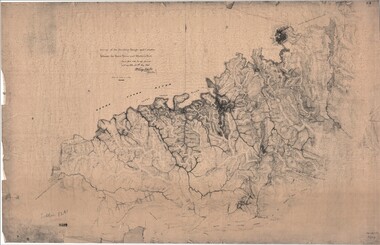
Map, Survey of Dividing Range between Yarra Yarra and Western Port - William Wedge Darke, 1843
... creeks along the higher ground that he labelled the "best line of road from Melbourne". This road was for many years the major route to Gippsland and to the higher country about Alexandra and Mansfield, sometimes known as White Horse Road, and now Maroondah Highway. Transmitted to the Surveyor General with my letter of 10th May 1843 (signed) Wm Wedge Drake, Assistant Surveyor. Scale: two inches to a mile. Descriptive remarks include upstream area of Yarra River - "impassable, appears to have been formerly a lake", and to the south - "barren and scrubby swamps ...Extract - Ringwood, Place of Many Eagles - Hugh Anderson (1974): William Wedge Darke, from Hereford, England, was a nephew of John Helder Wedge of the Port Phillip Association, who was also a surveyor. William's most important work was probably his survey of the Dividing Range and the country between the Yarra River and Western Port, completed in May 1843, and during which he made a traverse between the Mullum and Dandenong creeks along the higher ground that he labelled the "best line of road from Melbourne". This road was for many years the major route to Gippsland and to the higher country about Alexandra and Mansfield, sometimes known as White Horse Road, and now Maroondah Highway.Surveyor's relief map of features to the east of Melbourne including Yarra Yarra River, Mullum Mullum Creek, Anderson's Creek, Dandenong Creek.Transmitted to the Surveyor General with my letter of 10th May 1843 (signed) Wm Wedge Drake, Assistant Surveyor. Scale: two inches to a mile. Descriptive remarks include upstream area of Yarra River - "impassable, appears to have been formerly a lake", and to the south - "barren and scrubby swamps of the Western Port Country". Marked tracks include "best line of road from Melbourne", "track to Dandenong", "Road to Port Albert may probably be found on this range", "Best line to Upper Yarra". Several huts also marked. -
 City of Moorabbin Historical Society (Operating the Box Cottage Museum)
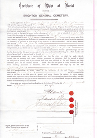
Certificate - Document, Certificate of Burial 1890, c1880
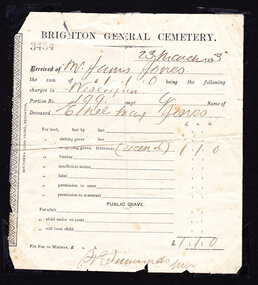
... Sadly infectious diseases took the lives of many infants throughout the Colony of Victoria due to the poor state of water supply and sewerage disposal and locally the swamps of the Elster Creek were a constant breeding ground. melbourne brighton moorabbin water supply pioneers bentleigh dendy henry market gardeners early settlers jones mary ann wesleyan church jones james vaccination typhoid dendys special survey 1841 infectious diseases elster creek jones martha brighton general cemetery Certificate of Right of Burial / IN THE / BRIGHTON GENERAL CEMETERY. ...James Jones was the son of Philip Jones, a Chairmaker, and Ann Jones who settled in East Brighton after the sale of land c1852 in the area of the Henry Dendy Special Survey of 1841. Mary Ann Moore was the daughter of Thomas Moore, a Gardener, and Sarah Harris who also settled in Brighton c1852. James and Mary Ann Jones settled and raised their family in East Brighton now Bentleigh. Mr John Herron resided at 4 Vickery St Bentleigh until 1989. Sadly Martha Jones born 1888 died in 1890 and James Jones had to purchase this plot at Brighton General Cemetery for her burial. A further 2 children were interred in 1893 and 1900 then Mary Ann in 1903 and James in 1940 James Jones and Mary Ann Moore were born in Brighton c1857 and c 1859 into pioneer market gardener families in the area of the Dendy Special Survey of 1841. They married in 1883 and raised their family in East Brighton, now Bentleigh. Sadly infectious diseases took the lives of many infants throughout the Colony of Victoria due to the poor state of water supply and sewerage disposal and locally the swamps of the Elster Creek were a constant breeding ground.An original paper Certificate of Right of Burial in The Brighton General Cemetery signed and dated by the Trustees of the Cemetery upon the application of James Jones of East Brighton, Victoria, 22nd April 1890. A plot , Register No. 2844, of 4 feet in width and 8 feet in depth in the Wesleyan Section, No. 199, compartment G in the Brighton General Cemetery. would be supplied upon payment of Two Pounds two shillings and receipt of same is acknowledged. Certificate of Right of Burial / IN THE / BRIGHTON GENERAL CEMETERY. Application of Mr James Jones of East Brighton for a plot to be supplied upon payment of Two Pounds and 2 Shillings and receipt of same acknowledged. Signed by the Trustees of the Cemetery, (4 signatures) in presence of S. Simmonds, dated twenty- second April 1890 Reverse side Dated 22nd April 1890 / Certificate of Right of Burial / IN THE / BRIGHTON GENERAL CEMETERY/ Mr James Jones ( hand written) / DENOMINATION Wesleyan / Compartment G / No. 199 Hand written on right side 3454 (signed) S Simmonds / 4797 (signed) S Simmonds / 36897 20/ 11 / 40 melbourne, brighton, moorabbin, water supply, pioneers, bentleigh, dendy henry, market gardeners, early settlers, jones mary ann, wesleyan church, jones james, vaccination, typhoid, dendys special survey 1841, infectious diseases, elster creek, jones martha, brighton general cemetery -
 City of Moorabbin Historical Society (Operating the Box Cottage Museum)
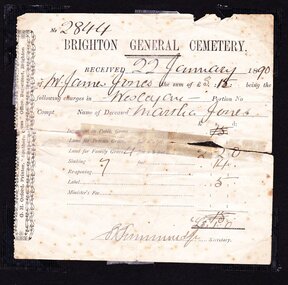
Certificate - Document, receipt burial 1890 Martha Jones, c1880
... Sadly infectious diseases took the lives of many infants throughout the Colony of Victoria due to the poor state of water supply and sewerage disposal and locally the swamps of the Elster Creek were a constant breeding ground. ...James Jones was the son of Philip Jones, a Chairmaker, and Ann Jones who settled in East Brighton after the sale of land c1852 in the area of the Henry Dendy Special Survey of 1841. Mary Ann Moore was the daughter of Thomas Moore, a Gardener, and Sarah Harris who also settled in Brighton c1852. James and Mary Ann Jones settled and raised their family in East Brighton now Bentleigh. Mr John Herron resided at 4 Vickery St Bentleigh until 1989. Sadly Martha Jones born 1888 died in 1890 and James Jones had to purchase a plot at Brighton General Cemetery for her burial. A further 2 children were interred in 1893 and 1900 then Mary Ann in 1903 and James in 1940James Jones and Mary Ann Moore were born in Brighton c1857 and c 1859 into pioneer market gardener families in the area of the Dendy Special Survey of 1841. They married in 1883 and raised their family in East Brighton, now Bentleigh. Sadly infectious diseases took the lives of many infants throughout the Colony of Victoria due to the poor state of water supply and sewerage disposal and locally the swamps of the Elster Creek were a constant breeding ground. Martha Jones born 1888 died 1890 and was interred in Brighton General Cemetery in a family plot purchased by her father James Jones. An original paper receipt No. 2844 for payment 22 January 1890 by James Jones to Brighton General Cemetery of 3 pounds 1 shilling for burial of Martha Jones aged approx. 2 years in a plot 4 feet x 8 feet. Fees include family grave at 2 pounds 2 shillings, Sinking to 7 feet at 14 shillings and Label 5 shillings .No. 2844( hand written) / BRIGHTON GENERAL CEMETERY / RECEIVED 22 January 18 90 / of Mr James Jones ( hand written ) the sum of £3. 1 being the / following charges in Wesleyan Portion No. / Compt. Name of deceased Martha Jones / Signed S Simmonds (handwritten) Secretary Along left side G.H Orford Printer “ Southern Cross Office” Bay St. Brighton melbourne, brighton, moorabbin, water supply, pioneers, bentleigh, dendy henry, market gardeners, early settlers, jones mary ann, wesleyan church, jones james, vaccination, typhoid, dendys special survey 1841, infectious diseases, elster creek, jones martha, brighton general cemetery, orford g h, printers, southern cross office, bay street brighton -
 City of Moorabbin Historical Society (Operating the Box Cottage Museum)
Certificate - Document, receipt Burial 1893 Ethel May Jones, c1890
... Sadly infectious diseases took the lives of many infants throughout the Colony of Victoria due to the poor state of water supply and sewerage disposal and locally the swamps of the Elster Creek were a constant breeding ground. ...James Jones was the son of Philip Jones, a Chairmaker, and Ann Jones who settled in East Brighton after the sale of land c1852 in the area of the Henry Dendy Special Survey of 1841. Mary Ann Moore was the daughter of Thomas Moore, a Gardener, and Sarah Harris who also settled in Brighton c1852. James and Mary Ann Jones settled and raised their family in East Brighton now Bentleigh. Mr John Herron resided at 4 Vickery St Bentleigh until 1989. Sadly Martha Jones born 1888 died in 1890 and James Jones had to purchase a plot at Brighton General Cemetery for her burial. Baby Ethel May was interred in 1893 and another baby in 1900 then Mary Ann in 1903 and James in 1940James Jones and Mary Ann Moore were born in Brighton c1857 and c 1859 into pioneer market gardener families in the area of the Dendy Special Survey of 1841. They married in 1883 and raised their family in East Brighton, now Bentleigh. Sadly infectious diseases took the lives of many infants throughout the Colony of Victoria due to the poor state of water supply and sewerage disposal and locally the swamps of the Elster Creek were a constant breeding ground. Martha Jones born 1888 died 1890 and was interred in Brighton General Cemetery in a family plot purchased by her father James Jones. In 1893 another daughter Ethel May died and was buried in the family plot. An original paper receipt No. 3454 for payment on 23 March 1893 by James Jones to Brighton General Cemetery of £1 . 1s For the burial of baby Ethel May Jones in a plot 4 feet x 8 feet, in the Wesleyan section portion 199 compartment G. Fee was for reopening the grave he had purchased in 1890 for the burial of his daughter Martha, aged 2 years . BRIGHTON GENERAL CEMETERY / 3454 ( stamped) / 23 March 1893 ( hand written ) / Received from Mr James Jones ( hand written ) / the sum of £1 . 1s being the following / charges in Wesleyan (hand written) / Portion No, 199 compt.G Name of / deceased Ethel May Jones ( handwritten) / for re-opening grave internment recent ( hand written) £1 . 1s / Signed S Simmonds ( ?manager) Along left side of receipt is printed SOUTHERN CROSS PRINT, BRIGHTON melbourne, brighton, moorabbin, water supply, pioneers, bentleigh, dendy henry, market gardeners, early settlers, jones mary ann, wesleyan church, jones james, vaccination, typhoid, dendys special survey 1841, infectious diseases, elster creek, jones martha, brighton general cemetery, orford g h, printers, southern cross office, bay street brighton, jones ethel may -
 City of Moorabbin Historical Society (Operating the Box Cottage Museum)
Certificate - Receipt for Burial of Stillborn Child, James & Mary Jones Child, 1900
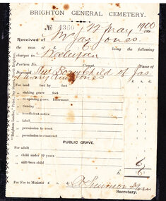
... Sadly infectious diseases took the lives of many infants throughout the Colony of Victoria due to the poor state of water supply and sewerage disposal and locally the swamps of the Elster Creek were a constant breeding ground. ...James Jones was the son of Philip Jones, a Chairmaker, and Ann Jones who settled in East Brighton after the sale of land c1852 in the area of the Henry Dendy Special Survey of 1841. Mary Ann Moore was the daughter of Thomas Moore, a Gardener, and Sarah Harris who also settled in Brighton c1852. James and Mary Ann Jones settled and raised their family in East Brighton now Bentleigh. Mr John Herron resided at 4 Vickery St Bentleigh until 1989. Sadly Martha Jones born 1888 died in 1890 and James Jones had to purchase a plot at Brighton General Cemetery for her burial. Baby Ethel May was interred in 1893 and then Mary Ann in 1903 and James in 1940. Their stillborn baby was buried in the Wesleyan public grave in 1900James Jones and Mary Ann Moore were born in Brighton c1857 and c 1859 into pioneer market gardener families in the area of the Dendy Special Survey of 1841. They married in 1883 and raised their family in East Brighton, now Bentleigh. Sadly infectious diseases took the lives of many infants throughout the Colony of Victoria due to the poor state of water supply and sewerage disposal and locally the swamps of the Elster Creek were a constant breeding ground. Martha Jones born 1888 died 1890 and was interred in Brighton General Cemetery in a family plot purchased by her father James Jones. In 1893 another daughter Ethel May died and was buried in the family plot. A stillborn baby was interred in the public grave of Brighton General Cemetery in May1900An original paper receipt No.4360 for payment on 22 May 1900 by James Jones to Brighton General Cemetery of 6 shillings for the burial of a stillborn baby Jones in the Wesleyan section of the public graves. There is no fee for ‘re-opening the grave’ purchased by James Jones in 1890 and in which his daughters Martha 1890 and Ethel May 1893 were interred. BRIGHTON GENERAL CEMETERY / No. 4360 (stamped) 22 May 1900 ( hand written) / Received of Mr Jas. Jones ( hand written) / the sum of 6 s being the following / charges in Wesleyan / Portion No. -- Compt. - Name of / Deceased ‘Stillborn child of Jas / & Mary Ann Jones’ (hand written) Along left side “Brighton Leader” Print, Bay Street, North Brighton This receipt is signed A Shimon man. Secretary wesleyan church, brighton general cemetery, vaccination, pioneers, early settlers, typhoid, brighton, moorabbin, bentleigh, market gardeners, jones james, jones mary ann, jones martha, dendy henry, dendys special survey 1841, infectious diseases, water supply, elster creek, melbourne, orford g h, printers, southern cross office, “brighton leader” print, bay street brighton, jones ethel may -
 City of Moorabbin Historical Society (Operating the Box Cottage Museum)
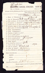
Certificate - Documents relating to Death and Burial of Mary Ann Jones, 1903
... Sadly infectious diseases took the lives of many infants throughout the Colony of Victoria due to the poor state of water supply and sewerage disposal and locally the swamps of the Elster Creek were a constant breeding ground. ...James Jones was the son of Philip Jones, a Chairmaker, and Ann Jones who settled in East Brighton after the sale of land c1852 in the area of the Henry Dendy Special Survey of 1841. Mary Ann Moore was the daughter of Thomas Moore, a Gardener, and Sarah Harris who also settled in Brighton c1852. James and Mary Ann Jones settled and raised their family in East Brighton now Bentleigh. Mr John Herron resided at 4 Vickery St Bentleigh until 1989. Sadly Martha Jones born 1888 died in 1890 and James Jones had to purchase a plot at Brighton General Cemetery for her burial. Baby Ethel May was interred in 1893 and then Mary Ann in 1903 and James in 1940. Their stillborn baby was buried in the Wesleyan public grave in 1900James Jones and Mary Ann Moore were born in Brighton c1857 and c 1859 into pioneer market gardener families in the area of the Dendy Special Survey of 1841. They married in 1883 and raised their family in East Brighton, now Bentleigh. Sadly infectious diseases took the lives of many infants throughout the Colony of Victoria due to the poor state of water supply and sewerage disposal and locally the swamps of the Elster Creek were a constant breeding ground. Martha Jones born 1888 died 1890 and was interred in Brighton General Cemetery in a family plot purchased by her father James Jones. In 1893 another daughter Ethel May died and was buried in the family plot. A stillborn baby was interred in the public grave of Brighton General Cemetery in May1900. Mary Ann Jones died at age 43years and was interred in January 19033 Original documents associated with the death of Mary Ann Jones 18th January 1903. 1) An original paper receipt No. 4797 for payment on 19th January 1903 by James Jones to Brighton General Cemetery of £1 . 1s for the burial of Mary Ann Jones in a plot 4 feet x 8 feet, in the Wesleyan section portion 199 compartment G. 2 ) An original part- section of Form of Notification of Death from The Alfred Hospital Prahran with personal particulars and burial details , signed by the Undertaker. 3) An original Mourning Card 1) BRIGHTON GENERAL CEMETERY / 4797 ( stamped) / 19th Jan. 1903 (hand written) / Received from “Mr James Jones”(hand written) / the sum of £1 . 1s being the following / charges in Wesleyan (hand written) / Portion No, 199 compt.G Name of / Deceased ‘Mary Ann Jones”(hand written) / For re-opening grave interment ‘third’ £1 . 1s./ signed by S. P. Simmonds Secretary. 2) ‘Brighton’ (written over Melbourne) GENERAL CEMETERY FORM OF… / No. of Order____ Date of… / PARTICULARS / Signature of Undertaker J H Lear On back of notice are guides to the questions 3) In Loving Remembrance of / Mary Ann Jones / Dearly Loved Wife of James Jones / Died January 18th 1903 / Aged 43 Years / Poem - “One Less at Home “ / DEEPLY REGRETTED / Art Engraving Company, Royal Arcade, Elizabeth Street, Melbourne * wesleyan church, brighton general cemetery, vaccination, pioneers, early settlers, typhoid, brighton, moorabbin, bentleigh, market gardeners, jones james, jones mary ann, jones martha, dendy henry, dendys special survey 1841, infectious diseases, water supply, elster creek, melbourne, orford g h, printers, southern cross office, “brighton leader” print, bay street brighton, jones ethel may, public grave brighton -
 City of Moorabbin Historical Society (Operating the Box Cottage Museum)
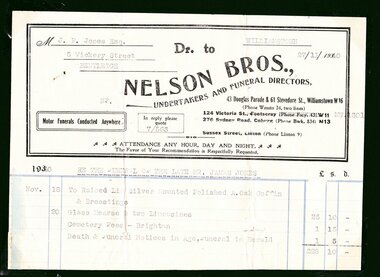
Certificate - Documents, Burial James Jones 1940, c1940
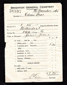
... Sadly infectious diseases took the lives of many infants throughout the Colony of Victoria due to the poor state of water supply and sewerage disposal and locally the swamps of the Elster Creek were a constant breeding ground. ...James Jones was the son of Philip Jones, a Chairmaker, and Ann Jones who settled in East Brighton after the sale of land c1852 in the area of the Henry Dendy Special Survey of 1841. Mary Ann Moore was the daughter of Thomas Moore, a Gardener, and Sarah Harris who also settled in Brighton c1852. James and Mary Ann Jones settled and raised their family in East Brighton now Bentleigh. Mr John Herron resided at 4 Vickery St Bentleigh until 1989. Sadly Martha Jones born 1888 died in 1890 and James Jones had to purchase a plot at Brighton General Cemetery for her burial. Baby Ethel May was interred in 1893 and then Mary Ann in 1903 and James in 1940. Their stillborn baby was buried in the Wesleyan public grave in 1900James Jones and Mary Ann Moore were born in Brighton c1857 and c 1859 into pioneer market gardener families in the area of the Dendy Special Survey of 1841. They married in 1883 and raised their family in East Brighton, now Bentleigh. Sadly infectious diseases took the lives of many infants throughout the Colony of Victoria due to the poor state of water supply and sewerage disposal and locally the swamps of the Elster Creek were a constant breeding ground. Martha Jones born 1888 died 1890 and was interred in the Brighton General Cemetery in a family plot, in the Wesleyan Section, purchased by her father James Jones. In 1893 another daughter Ethel May died and was buried in the family plot. A stillborn baby was interred in the public grave of Brighton General Cemetery in May1900. Mary Ann Jones died, at age 43years, and was interred in January 1903. Finally in November 1940 Mr James Jones was buried in the family grave. 2 original paper Receipts associated with the Burial of James Jones at Brighton General Cemetery 20th November 1940 by Nelson Bros. Funeral Directors of Williamstown1) 4202 Re the Funeral of the late Mr James Jones / 43 Douglas Parade Williamstown (Tel 34 & 43)/ 27/11/1940 / Received from Mr J P Jones./ by CHEQUE/ CASH the sum of Twenty eight pounds / ten shillings - pence/ WITH MANY THANKS / 7/563 / NELSON BROS./ £28:10:0 per N.Flack / THIS is our only recognised form of receipt / In full settlement / Stamped VICTORIA STAMP DUTY 3d 2) 36897 BRIGHTON GENERAL CEMETERY 20November 1940/ Received of Nelson Bros./ the sum of £1.15.- being the following charges/ in Methodist / Portion No. 199 Compt. G / Name of Deceased James Jones / for reopening grave £1.15.- / signed C Guy Secretarywesleyan church, brighton general cemetery, vaccination, pioneers, early settlers, typhoid, brighton, moorabbin, bentleigh, market gardeners, jones james, jones mary ann, jones martha, dendy henry, dendys special survey 1841, infectious diseases, water supply, elster creek, melbourne, orford g h, printers, southern cross office, “brighton leader” print, bay street brighton, jones ethel may, public grave brighton -
 City of Moorabbin Historical Society (Operating the Box Cottage Museum)
Certificate - Documents, Funeral James Jones 1940, c1940
... Sadly infectious diseases took the lives of many infants throughout the Colony of Victoria due to the poor state of water supply and sewerage disposal and locally the swamps of the Elster Creek were a constant breeding ground. ...James Jones was the son of Philip Jones, a Chairmaker, and Ann Jones who settled in East Brighton after the sale of land c1852 in the area of the Henry Dendy Special Survey of 1841. Mary Ann Moore was the daughter of Thomas Moore, a Gardener, and Sarah Harris who also settled in Brighton c1852. James and Mary Ann Jones settled and raised their family in East Brighton now Bentleigh. Mr John Herron resided at 4 Vickery St Bentleigh until 1989. Sadly Martha Jones born 1888 died in 1890 and James Jones had to purchase a plot at Brighton General Cemetery for her burial. Baby Ethel May was interred in 1893 and then Mary Ann in 1903 and finally James in 1940. Their stillborn baby was buried in the Wesleyan public grave in 1900James Jones and Mary Ann Moore were born in Brighton c1857 and c 1859 into pioneer market gardener families in the area of the Dendy Special Survey of 1841. They married in 1883 and raised their family in East Brighton, now Bentleigh. Sadly infectious diseases took the lives of many infants throughout the Colony of Victoria due to the poor state of water supply and sewerage disposal and locally the swamps of the Elster Creek were a constant breeding ground. Martha Jones born 1888 died 1890 and was interred in the Brighton General Cemetery in a family plot, in the Wesleyan Section, purchased by her father James Jones. In 1893 another daughter Ethel May died and was buried in the family plot. A stillborn baby was interred in the public grave of Brighton General Cemetery in May1900. Mary Ann Jones died, at age 43years, and was interred in January 1903. Finally in November 1940 Mr James Jones was buried in the family grave. 1 original paper account and 1 paper receipt from Nelson Bros. Funeral Directors re the funeral of James Jones in November 19401) M..J.P Jones Esq./ 5 Vickery Street/ Bentleigh / WILLIAMSTOWN/ 27/11/1940 Dr to / NELSON BROS.,/UNDERTAKERS AND FUNERAL DIRECTORS, / 43 Douglas Parade & 51 Stevedore St., Williamstown W16 / Motor Funerals Conducted Anywhere / In reply please quote 7/563/ Re The Funeral of The Late MR. JAMES JONES/ £28:10:0 -1 Glass Hearse & 2 Limousines, Cemetery Fees and Newspaper notices 2) As above / 27/111940 / A Memo. from NELSON BROS.,/ Dear Sir, /Herewith ...our official receipt... / signed A Nelson / Manager* wesleyan church, brighton general cemetery, vaccination, pioneers, early settlers, typhoid, brighton, moorabbin, bentleigh, market gardeners, jones james, jones mary ann, jones martha, dendy henry, dendys special survey 1841, infectious diseases, water supply, elster creek, melbourne, orford g h, printers, southern cross office, “brighton leader” print, bay street brighton, jones ethel may -
 City of Moorabbin Historical Society (Operating the Box Cottage Museum)
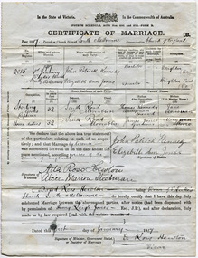
Document - Wedding Certificate, Elizabeth Jones, c1917
... Sadly infectious diseases took the lives of many infants throughout the Colony of Victoria due to the poor state of water supply and sewerage disposal and locally the swamps of the Elster Creek were a constant breeding ground. ...James Jones was the son of Philip Jones, a Chairmaker, and Ann Jones who settled in East Brighton after the sale of land c1852 in the area of the Henry Dendy Special Survey of 1841. Mary Ann Moore was the daughter of Thomas Moore, a Gardener, and Sarah Harris who also settled in Brighton c1852. James and Mary Ann Jones settled and raised their family in East Brighton now Bentleigh. They sadly lost Martha Jones born 1888 died in 1890 ,and. Baby Ethel May died 1893 and a stillborn baby was buried in 1900. However, their daughter Elizabeth Ann Jones born 1885 married John Patrick Kennedy born 1885, a the son of Thomas Kennedy , Dairyman deceased, and Jane Donovan early settlers in the Brighton area, at South Melbourne in January 1917 . James Jones and Mary Ann Moore were born in Brighton c1857 and c 1859 into pioneer market gardener families in the area of the Dendy Special Survey of 1841. They married in 1883 and raised their family in East Brighton, now Bentleigh. Sadly infectious diseases took the lives of many infants throughout the Colony of Victoria due to the poor state of water supply and sewerage disposal and locally the swamps of the Elster Creek were a constant breeding ground. Martha Jones born 1888 died 1890 and was interred in the Brighton General Cemetery. In 1893 another daughter Ethel May died and stillborn baby in May1900. Mary Ann Jones died, at age 43years, in January 1903 and in November 1940 Mr James Jones was buried in the family grave. Their daughter Elizabeth Ann Jones , born 1885, married John Patrick Kennedy, born 1885, the son of Thomas Kennedy, a dairyman and Jane Donovan also early settlers in Brighton area at St Luke’s Anglican Church in South Melbourne in January 1917 Original Certificate of Marriage of Elizabeth Ann Jones, the daughter of James and Mary Ann Jones, to John Patrick Kennedy at St Luke's Anglican Church in South Melbourne on January 1st 1917In the State of Victoria/ crest/ In the Commonwealth of Australia/FOURTH SCHEDULE ACTSNOS. 2691 and 2720 -FORM B/ CERTIFICATE OF MARRIAGE B/ Year 1917Parish or Church District South Melbourne Denomination Church of England/ signed by Patrick Kennedy and Elizabeth Jones, witnesses Ada Hewton and Alice Steedman and Vicar David Ross Hewton dated this first day of January 1917anglican church, st luke's south melbourne, jones elizabeth ann, kennedy john patrick, kennedy thomas, donovan jane, dairyman, dairy farms, brighton general cemetery, vaccination, pioneers, early settlers, typhoid, brighton, moorabbin, bentleigh, market gardeners, jones james, jones mary ann, jones martha, dendy henry, dendys special survey 1841, infectious diseases, water supply, elster creek, melbourne, jones ethel may, reverend hewton david ross -
 City of Moorabbin Historical Society (Operating the Box Cottage Museum)
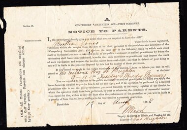
Document - Medical Health, vaccination notice, Martha Jones, c1888
... Sadly infectious diseases took the lives of many infants throughout the Colony of Victoria due to the poor state of water supply and sewerage disposal and locally the swamps of the Elster Creek were a constant breeding ground. vaccination pioneers early settlers typhoid brighton moorabbin bentleigh market gardeners fruit gardens jones james jones mary ann jones martha dendy henry dendys special survey 1841 infectious diseases water supply elster creek melbourne A / COMPULSORY VACCINATION ACT – FIRST SCHEDULE / Section 17 / NOTICE TO PARENTS. ...The loss of life from infectious diseases such as Typhoid in the pioneer settlements of Australia, was very high Hence the free, compulsory vaccination of infants within 6 months of their birth. This Notice To Parents was sent by the Deputy Registrar of Births and Deaths in District of East Brighton , now known as Bentleigh. The notice states that all Public Vaccinators ‘ are supplied with Calf lymph. Parents can chose which Lymph they prefer”James Jones and Mary Ann Moore were born in Brighton c1857 and c 1859 into pioneer market gardener families in the area of the Dendy Special Survey of 1841. They married in 1883 and raised their family in East Brighton, now Bentleigh. Sadly infectious diseases took the lives of many infants throughout the Colony of Victoria due to the poor state of water supply and sewerage disposal and locally the swamps of the Elster Creek were a constant breeding ground. An original paper Notice To Parents for the Compulsory Vaccination Act , First Schedule, 13th August 1888 following the registration of the birth of Martha Jones to James and Mary Ann Jones in Brighton Victoria.A / COMPULSORY VACCINATION ACT – FIRST SCHEDULE / Section 17 / NOTICE TO PARENTS. Typed along left side “ (N.B. All Public Vaccinators are supplied with Calf Lymph. Parents can chose which Lymph they prefer)” This paper notice naming the child Martha Jones is signed and dated by the Deputy Registrar of Births and Deaths of the District of East Brighton , W. Ward, on 13th August 1888, and gives the dates and times he will be in attendance ‘ at his residence’ for the said vaccination. vaccination, pioneers, early settlers, typhoid, brighton, moorabbin, bentleigh, market gardeners, fruit gardens, jones james, jones mary ann, jones martha, dendy henry, dendys special survey 1841, infectious diseases, water supply, elster creek, melbourne -
 Orbost & District Historical Society
black and white photograph, 1920s
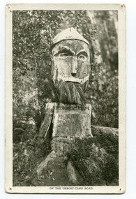
... Creek, on the old Princess Highway, between Orbost and Cann River. The carved face was said to mock the supervising engineer after an argument about putting the road alignment across a swamp that required new bridges. ...Creek, on the old Princess Highway, between Orbost and Cann River. The carved face was said to mock the supervising engineer after an argument about putting the road alignment across a swamp that required new bridges. ...Pons asinorum was the name given to a wooden carving made by road worker Finlay Munro in the early 1920s at Boulder Creek, on the old Princess Highway, between Orbost and Cann River. The carved face was said to mock the supervising engineer after an argument about putting the road alignment across a swamp that required new bridges. The Italian workmen had advocated for a different route to avoid the need for building new bridges across the swamp. This photograph is from a set of thirteen black and white postcards in a fold-out format.This is a photograph of an iconic tourist attraction which records the woodworking skills of workers in the early 20th century. The carving is no longer there.A small black / white photograph of a face carved into a tree stump.on front at bottom - ON THE ORBOST CANN ROADwoodcarving pons-asinorum boulder-creek-east-gippsland princess-highway -
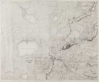 Federation University Historical Collection
Map, Ballaarat Gold Field, 1861, 1861
... swamp...little bendigo diggings...gold leads...old post office hill...specimen hill...bakery hill...black hill...dead horse creek...In November 2004 the Central Highlands Regional Library presented a special edition of 200 copies of the 1861 map reproduced from a copy in their collection. ballarat map ballarat east lake wendouree survey mines robert davidson ballarat gold field 1861 yuille's swamp wendouree swamp little bendigo diggings gold leads old post office hill specimen hill bakery hill black hill dead horse creek brown hill pennyweight hill clayton hill soldiers hill golden point gum tree flat white flat poverty hill chinese village robert brough smyth Ballarat map 1861 Ballaarat Vineyard Dead Horse Gully Deadhorse Creek Invermay Black Hill Flat Gaelic Church Police Reserve Magpie Range Dalton's Flat Caadian Lead Rifle Butts Powder Magazine Bathing House Government Camp Gold Office Chinese Llanberrris Victoria Theatre Charlie Napier Hotel United States Hotel Grape's Hoel Clayton's Hill Cattleyard Hill Free Trade Hotel Esmond Lead Bakery Hill Black Hill Lead Juvenile Reformatory Ballarat Orphanage Lady Barkly Lead Triffet's Slaughter Yard Little Bendigo Melbourne Road T. ...A party of surveyors camped by Yuille's Swamp (later Lake Wendouree) and surveyed the countryside for a map to be produced by the Geological Survey of Victoria. In November 2004 the Central Highlands Regional Library presented a special edition of 200 copies of the 1861 map reproduced from a copy in their collection. Original 1861 map of Ballarat showing streets and leads. Blue dots indicate gold leads, and red lines indicate auriferous quartz reef and outcrops of quartz veins."Compiled & Drawn from the Survey of Mining Surveyors Davidson, Fitzpatrick and Cowan & the Plans in the Surveyor General's Office by J. Brahe, 21st October 1861. R. Brough Smyth, Secretary for Mines. The Honourable J.B. Humffray, M.L.A. Commr of Mines.”ballarat, map, ballarat east, lake wendouree, survey, mines, robert davidson, ballarat gold field 1861, yuille's swamp, wendouree swamp, little bendigo diggings, gold leads, old post office hill, specimen hill, bakery hill, black hill, dead horse creek, brown hill, pennyweight hill, clayton hill, soldiers hill, golden point, gum tree flat, white flat, poverty hill, chinese village, robert brough smyth, ballarat map 1861, ballaarat vineyard, dead horse gully, deadhorse creek, invermay, black hill flat, gaelic church, police reserve, magpie range, dalton's flat, caadian lead, rifle butts, powder magazine, bathing house, government camp, gold office, chinese, llanberrris, victoria theatre, charlie napier hotel, united states hotel, grape's hoel, clayton's hill, cattleyard hill, free trade hotel, esmond lead, bakery hill, black hill lead, juvenile reformatory, ballarat orphanage, lady barkly lead, triffet's slaughter yard, little bendigo, melbourne road, t. cowan, thomas cowan -
 Federation University Historical Collection
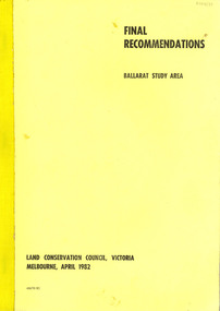
Book, Final recommendations Ballarat Study Area Land Conservation Council, Victoria, 1982, 1982
... swamp...dereel lagoon...lake bolac...lake wongan...langi ghiran reservoir...gong gong reservoir...pincotts reservoir...beales reservoir...wilsons reservoir...moorabool reservoir...korweinguboora...korweinguborra reservoir...learmonth bores...sago hill...illabarook reservoir...ballarat water commission...dunneworthy...mount cole...mont lonarch...ben major...waterloo...trawalla...linton...ross creek...Barker Library (top floor) Mount Helen goldfields land conservation authority ballarat endowment plantations pine plantations langi ghiran state park mount buangor state park enfield state park ballarat-creswick regional park rossbridge black lake flax mill swamp dereel lagoon lake bolac lake wongan langi ghiran reservoir gong gong reservoir pincotts reservoir beales reservoir wilsons reservoir moorabool reservoir korweinguboora korweinguborra reservoir learmonth bores sago hill illabarook reservoir ballarat water commission dunneworthy mount cole mont lonarch ben major waterloo trawalla linton ross creek canadian shepherds flat lal lal mount doran raglan chute carngham buninyong watsons hill enfield cape clear illabrook rokewood junction mount warrenheip nerrina jubilee golden stream australasian deep lead mine happy valley school piggoreet berringa bulldog ballarat common wildlife water timber flora rivers geology agriculture warrenheip biodiversity Yellow soft covered report of 95 pages . ...Yellow soft covered report of 95 pages . The contents of the report include: Parks, reference areas, wildlife reserves, water production, hardwood production, softwood production, flora Reserves and Flora and Fauna reserves, bushland reserves, historic area and reserves, rivers and streams, Roadside conservation and Highway parks, Education areas and School Plantations, Lake Reserves, geological reserves, recreation, scenic reserves, agriculture, mineral and stone production, utilities and survey, township land, Uncommitted Land, military training, other reserves and public land. Maps include: The Study area 1: 250 000 Supplementary Mapsland conservation authority, ballarat, endowment plantations, pine plantations, langi ghiran state park, mount buangor state park, enfield state park, ballarat-creswick regional park, rossbridge, black lake, flax mill swamp, dereel lagoon, lake bolac, lake wongan, langi ghiran reservoir, gong gong reservoir, pincotts reservoir, beales reservoir, wilsons reservoir, moorabool reservoir, korweinguboora, korweinguborra reservoir, learmonth bores, sago hill, illabarook reservoir, ballarat water commission, dunneworthy, mount cole, mont lonarch, ben major, waterloo, trawalla, linton, ross creek, canadian, shepherds flat, lal lal, mount doran, raglan, chute, carngham, buninyong, watsons hill, enfield, cape clear, illabrook, rokewood junction, mount warrenheip, nerrina, jubilee, golden stream, australasian deep lead mine, happy valley school, piggoreet, berringa, bulldog, ballarat common, wildlife, water, timber, flora, rivers, geology, agriculture, warrenheip, biodiversity -
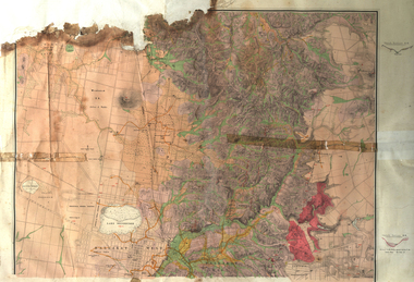 Federation University Historical Collection
Map, Ballarat Goldfield, c1898
... Creek...Black Swamp Lead...The Ballarat Industrial School ran from 1869-1879, but the term Ballarat Industrial School Reserve was still in use in 1898 and possibly beyond. ballarat warrenheip lake wendouree ballarat east winters swamp winter swamp wyndholm premptive right cemetery vale park reserve little bendigo kneeshaw co. industrial school reserve kirks dam pincotts dam black hill wombat hill dead horse gully miners rest mt rowan salton and waldie rose hill co great north west no 1 rose's freehold co hand and band co police reserve police paddock mount rowan ballarat industrial school reserve market reserve Winter's swamp Kneeshar Co Monte Cristo line of reef Chinaman's Gully or Black Snake Milkmaid's Gully Ballarat gold field Bakery Hil Lead Old gravel pits lead Golden point lead Eureka Lead Miner's Rest Yarrowee Creek Leigh Creek Black Swamp Lead Yorkshire Reef Nil Desperandum reef Cockatoo Lead HIt or Miss Gully herbert werner frederick de nully Pennyweight Hill Esmond's Lead Ash's Lead Nightingale Lead John Bull Gully Gladstone Reef Whitehorse reef Petticoat Creek Pincott's Dam Frenchman's Gully Tim's Crushing Plant Jenkin's Gully California Gully Drake's Creek Sulton and Waldie Ballarat Undustrial School Ballarat & Mariborough Railway Geological Map of Ballarat with 3 holes in the left hand side. ...This map shows geological features, suggests the last basalt flow, and includes alotments and names of Mining Companies. Although this map has no date on it the Ballarat Industrial School is used for dating purposed. The Ballarat Industrial School ran from 1869-1879, but the term Ballarat Industrial School Reserve was still in use in 1898 and possibly beyond.Geological Map of Ballarat with 3 holes in the left hand side. The map indicates the position of Lake Wendouree, Township of Warrenheip, Ballarat East, Industrial School Reserve, Winters Swamp, Police Paddock, Wyndholm Premptive Right (Salton and Waldie), Black Hill, Vale Park Reserve, Pennyweight Hill, Little Bendigo, Black Swamp Lead, monte Christo Reef, Chinaman's Gully, Miners Rest, Pincotts Dam, Northumberland Gully. It also show the following goldmining companies: City of Ballarat, Kohinor, Hand and Band, Great North West, Northern Junction, Kneeshaw, Rossers Freehold, Silurial.ballarat, warrenheip, lake wendouree, ballarat east, winters swamp, winter swamp, wyndholm premptive right, cemetery, vale park reserve, little bendigo, kneeshaw co., industrial school reserve, kirks dam, pincotts dam, black hill, wombat hill, dead horse gully, miners rest, mt rowan, salton and waldie, rose hill co, great north west no 1, rose's freehold co, hand and band co, police reserve, police paddock, mount rowan, ballarat industrial school reserve, market reserve, winter's swamp, kneeshar co, monte cristo line of reef, chinaman's gully or black snake, milkmaid's gully, ballarat gold field, bakery hil lead, old gravel pits lead, golden point lead, eureka lead, miner's rest, yarrowee creek, leigh creek, black swamp lead, yorkshire reef, nil desperandum reef, cockatoo lead, hit or miss gully, herbert werner frederick de nully, pennyweight hill, esmond's lead, ash's lead, nightingale lead, john bull gully, gladstone reef, whitehorse reef, petticoat creek, pincott's dam, frenchman's gully, tim's crushing plant, jenkin's gully, california gully, drake's creek, sulton and waldie, ballarat undustrial school, ballarat & mariborough railway