Showing 82 items matching "talbot hill"
-
 Port Melbourne Historical & Preservation Society
Booklet, Talbot and Leslie Hill, Port of Call, Oct 1997
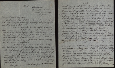
... ...talbot hill...'Port of Call' - Presentation by Talbot and Leslie Hill for AIGS meeting at Box Hill, 8.10.1997, listing a heritage walk devised by Talbot and Les....Talbot and Leslie Hill...Port of Call Booklet Talbot and Leslie Hill ...'Port of Call' - Presentation by Talbot and Leslie Hill for AIGS meeting at Box Hill, 8.10.1997, listing a heritage walk devised by Talbot and Les.built environment, education, talbot hill, leslie hill, wilbraham frederick evelyn liardet, wfe liardet, william wedge darke, robert hoddle, heritage walk -
Port Melbourne Historical & Preservation Society
Document - Newsletter, South Melbourne/Port Melbourne Historical and Preservation Society, Sep 1984
... ...Talbot HILL...Emerald Hill South Melbourne Societies Clubs Unions and other Organisations Town Planning South Melbourne - Port Melbourne Historical & Preservation Society Kay ROWAN Adair BUNNETT Les HILL Talbot HILL Robert BAKER Anne FAHEY Flo BURKE National Trust of Victoria One of three bulletins of the South Melbourne/Port Melbourne Historical & Preservation Society: September 1984. 16 unbound pages, A5, maize cover Document Newsletter, South Melbourne/Port Melbourne Historical and Preservation Society South Melbourne - Port Melbourne Historical & Preservation Society ...Given to Society by Wendy LOWENSTEIN in 1998. The SMPMH&PS existed between the 1970s and approx. 1990.One of three bulletins of the South Melbourne/Port Melbourne Historical & Preservation Society: September 1984. 16 unbound pages, A5, maize coveremerald hill, south melbourne, societies clubs unions and other organisations, town planning, south melbourne - port melbourne historical & preservation society, kay rowan, adair bunnett, les hill, talbot hill, robert baker, anne fahey, flo burke, national trust of victoria -
Port Melbourne Historical & Preservation Society
Document - Newsletter, South Melbourne/Port Melbourne Historical and Preservation Society, Sep 1984
... ...Talbot HILL...Emerald Hill South Melbourne Societies Clubs Unions and other Organisations Town Planning South Melbourne - Port Melbourne Historical & Preservation Society Kay ROWAN Adair BUNNETT Les HILL Talbot HILL Robert BAKER Anne FAHEY Flo BURKE National Trust of Victoria Dot WHARRIE One of three Bulletins of the South Melbourne/Port Melbourne Historical & Preservation Society: October 1984. 16 unbound pages, A5, maize cover Document Newsletter, South Melbourne/Port Melbourne Historical and Preservation Society South Melbourne - Port Melbourne Historical & Preservation Society ...Given to Society by Wendy LOWENSTEIN in 1998. The SMPMH&PS existed between the 1970s and approx. 1990.One of three Bulletins of the South Melbourne/Port Melbourne Historical & Preservation Society: October 1984. 16 unbound pages, A5, maize coveremerald hill, south melbourne, societies clubs unions and other organisations, town planning, south melbourne - port melbourne historical & preservation society, kay rowan, adair bunnett, les hill, talbot hill, robert baker, anne fahey, flo burke, national trust of victoria, dot wharrie -
Port Melbourne Historical & Preservation Society
Document - Newsletter, South Melbourne/Port Melbourne Historical and Preservation Society, Historical News, Sep 1981
... Given to Society by Talbot Hill in 2003. The SMPMH&PS existed between the 1970s and approx. 1990....Port Melbourne Historical & Preservation Society Port Melbourne Town Hall 333 Bay Street Port Melbourne melbourne Given to Society by Talbot Hill in 2003. The SMPMH&PS existed between the 1970s and approx. 1990. emerald hill south melbourne societies clubs unions and other organisations town planning south melbourne-port melbourne historical & preservation society john robert buxton william parton buckhurst 'Historical News'- One of three bulletins of the South Melbourne/Port Melbourne Historical & Preservation Society: Volume 3 No. 1, September 1981. 20 pages, A4, beige cover Historical News Document Newsletter, South Melbourne/Port Melbourne Historical and Preservation Society South Melbourne - Port Melbourne Historical & Preservation Society ...Given to Society by Talbot Hill in 2003. The SMPMH&PS existed between the 1970s and approx. 1990.'Historical News'- One of three bulletins of the South Melbourne/Port Melbourne Historical & Preservation Society: Volume 3 No. 1, September 1981. 20 pages, A4, beige coveremerald hill, south melbourne, societies clubs unions and other organisations, town planning, south melbourne-port melbourne historical & preservation society, john robert buxton, william parton buckhurst -
Federation University Historical Collection
Report, Goldfields Regional Tourism Development Plan, 1997, 1997
... talbot...wedderburn...sovereign hill...Barker Library (top floor) Mount Helen goldfields goldfields of victoria goldfields tourism marketing tourism road transport rail transportair transport aboriginal cultural heritage tourism victoria ballarat maryborough bendigo maldon clunes creswick dunolly ararat avoca stawell st arnaud daylesford goldfields railway statistics volcanos castlemaine talbot wedderburn sovereign hill bendigo joss house great westerngoldfields touring route freat southern touring route ballarat trams eureka centre ballarat east engine sheds port phillip mine, Clunes bendigo gasworks bendigo cathedral central deborah mine victoria hill mine the great stupa of australia diggings trail castlemaine market castlemaine-maldon tourist railway White bound report with clear cover Goldfields Regional Tourism Development Plan, 1997 Report ...White bound report with clear covergoldfields of victoria, goldfields tourism, marketing, tourism, road transport, rail transportair transport, aboriginal cultural heritage, tourism victoria, ballarat, maryborough, bendigo, maldon, clunes, creswick, dunolly, ararat, avoca, stawell, st arnaud, daylesford, goldfields railway, statistics, volcanos, castlemaine, talbot, wedderburn, sovereign hill, bendigo joss house, great westerngoldfields touring route, freat southern touring route, ballarat trams, eureka centre, ballarat east engine sheds, port phillip mine, clunes, bendigo gasworks, bendigo cathedral, central deborah mine, victoria hill mine, the great stupa of australia, diggings trail, castlemaine market, castlemaine-maldon tourist railway -
Lakes Entrance Historical Society
Book, The Maryborough Region Bushfire January 14 1985, 1985
... The story of the fire which devastated the Central Victorian region on Monday, January 14, 1985.Towns and locations were Bung Bong, Amherst, Talbot, Dunach, Daisy Hill, McCallums Creek, Majorca, Bristol Hill, Maryborough and Carisbrook. ...Lakes Entrance Historical Society 4 Marine Parade Lakes Entrance gippsland Natural Disasters Photography The story of the fire which devastated the Central Victorian region on Monday, January 14, 1985.Towns and locations were Bung Bong, Amherst, Talbot, Dunach, Daisy Hill, McCallums Creek, Majorca, Bristol Hill, Maryborough and Carisbrook. ...The story of the fire which devastated the Central Victorian region on Monday, January 14, 1985.Towns and locations were Bung Bong, Amherst, Talbot, Dunach, Daisy Hill, McCallums Creek, Majorca, Bristol Hill, Maryborough and Carisbrook. Illustrated withnatural disasters, photography -
 Surrey Hills Historical Society Collection
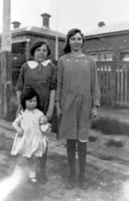
Photograph, Sylvia and Lena Jackson outside their home, 7-9 Russell Street, Surrey Hills
... Sylvia was born 20 July 1914 at Nurse Talbot's Hospital in Surrey Hills; d 2008....Hills Historical Society Collection 190A Canterbury Road Canterbury melbourne Eleanor (Lena) and Sylvia were 2 of the 11 children of Alice Eleanor (1868-1924) and George James Jackson (1868-1950). Another was George Hall Jackson - AIF no 4660. The Jacksons were both jewellers and married in 1890, migrating from England. Lena was born 16 December 1911; d. 30 May 1984. She married Walter John Rea Dawson. Sylvia was born 20 July 1914 at Nurse Talbot's ...Eleanor (Lena) and Sylvia were 2 of the 11 children of Alice Eleanor (1868-1924) and George James Jackson (1868-1950). Another was George Hall Jackson - AIF no 4660. The Jacksons were both jewellers and married in 1890, migrating from England. Lena was born 16 December 1911; d. 30 May 1984. She married Walter John Rea Dawson. Sylvia was born 20 July 1914 at Nurse Talbot's Hospital in Surrey Hills; d 2008.A black and white photograph of three young girls outside 7-9 Russell Street, Surrey Hills. The two taller girls are identified as Sylvia and Lena Jackson, whilst the small girl is unidentified.russell street, surrey hills, 1911, jewellers, clothing and dress, (miss) lena jackson, (miss) sylvia jackson, (miss) eleanor jackson, (mr) george jackson, (mrs) alice jackson, nurse talbot's hospital, mr walter dawson -
 8th/13th Victorian Mounted Rifles Regimental Collection
Bronze plaque, 1900 circa
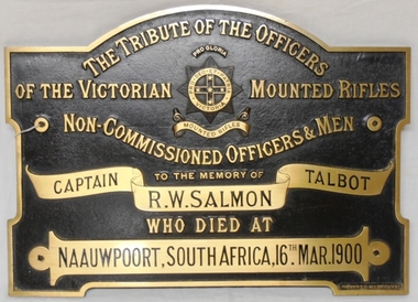
... Captain Robert Westrup Salmon was born at Daisy Hill near Talbot 12 July 1862. He joined the Victorian Mounted Rifles in 1883; was commissioned Lieutenant in 1892 and appointed Adjutant (Volunteer) of 2nd Battalion VMR in 1892. ...8th/13th Victorian Mounted Rifles Regimental Collection 4/19 Prince of Wales's Light Horse Simpson Barracks McLeod melbourne Captain Robert Westrup Salmon was born at Daisy Hill near Talbot 12 July 1862. He joined the Victorian Mounted Rifles in 1883; was commissioned Lieutenant in 1892 and appointed Adjutant (Volunteer) of 2nd Battalion VMR in 1892. ...Captain Robert Westrup Salmon was born at Daisy Hill near Talbot 12 July 1862. He joined the Victorian Mounted Rifles in 1883; was commissioned Lieutenant in 1892 and appointed Adjutant (Volunteer) of 2nd Battalion VMR in 1892. He embarked with the 1st Contingent VMR to South Africa in 1899 with the rank of captain. At the battle of Jasfontein (Garsfontein) he was highly complimented in the London Times and other English newspapers for the skilful manner in which he handled the Mounted Infantry under his command. At the time of his death from Enteric Fever on 16 March 1900 at Naauwpoort South Africa he was Staff Captain of the Australian Regiment. Captain Salmon was a councillor of the Borough of Talbot, trustee of the Racing Club and the Cemetery; member of the Board of Directors of the MUIOOF; past master of the Masonic Lodge; church warden of St Michael’s Church Talbot and secretary of the Fire Brigade. The plaque was discovered by retired Military Police officer, Captain Watson and donated to 8/13 VMR Museum circa 1983. Rare example of a memorial plaque to an officer of the Boer War. It is not known where or if it was originally mounted but a church building would seem likely. Large bronze plaque to the memory of Captain Robert Westrup Salmon who died of Enteric Fever while serving with the 1st Contingent Victorian Mounted Rifles during the Boer War. A framed display with photograph of the donor Captain Watson handing the plaque to Officer Commanding 'A' Squadron 8/13 VMR at Buna Barracks Albury in 1984 now accompanies the bronze plaque.Cast in raised lettering surrounding a Victorian Mounted Rifles badge "The tribute of the Officers of the Victorian Mounted Rifles Non-Commissioned Officers & Men to the memory of Captain RS Salmon Talbot who died at Naauwpoort South Africa 16th Mar. 1900"salmon robert westrup captain, talbot, boer war -
 Bendigo Military Museum
Photograph - Army Survey Regiment – Corps Day Parade and Defence Force Service Medal Presentations, Fortuna Villa, Bendigo, 1987
... Middle Row L to R: unidentified, SGT John ‘Stormy’ Tempest, CPL Perry Burt, SPR Rick Millar, CPL Graeme Priestley, SGT Bruce Hammond, CPL Max Watson, SPR Brett Parkin, SPR Peter Ball, CPL Dick Warsing, SPR Sue (Foote) Bourne, SPR Sandy Wynn, CPL Steve Hill OAM CSM, CPL Steve Rundle, CPL Andy Mallon, SPR Stafford Lester, SPR Steve Moss, CPL Rod Burton. Front Row L to R: SGT Ken Talbot-Smith, SSGT Phil Boyle, SSGT Max Coletti, WO2 Peter Tangey, LT Brian Sloan, WO1 Stevo Hinic, OC Maj Daryl Hockings CSM, CAPT Laurie Newton, WO1 Denis Marshall, SSGT Neil ‘Ned’ Kelly, SSGT Dennis McCarthy, SSGT Adrian ‘Charlie’ Creedy, SGT Barry Craymer, SSGT John ‘Shep’ Shephard. .16) - Photo, black & white, July 1987. ...Middle Row L to R: unidentified, SGT John ‘Stormy’ Tempest, CPL Perry Burt, SPR Rick Millar, CPL Graeme Priestley, SGT Bruce Hammond, CPL Max Watson, SPR Brett Parkin, SPR Peter Ball, CPL Dick Warsing, SPR Sue (Foote) Bourne, SPR Sandy Wynn, CPL Steve Hill OAM CSM, CPL Steve Rundle, CPL Andy Mallon, SPR Stafford Lester, SPR Steve Moss, CPL Rod Burton. Front Row L to R: SGT Ken Talbot-Smith, SSGT Phil Boyle, SSGT Max Coletti, WO2 Peter Tangey, LT Brian Sloan, WO1 Stevo Hinic, OC Maj Daryl Hockings CSM, CAPT Laurie Newton, WO1 Denis Marshall, SSGT Neil ‘Ned’ Kelly, SSGT Dennis McCarthy, SSGT Adrian ‘Charlie’ Creedy, SGT Barry Craymer, SSGT John ‘Shep’ Shephard. .16) - Photo, black & white, July 1987. ...This set of 18 photographs were taken at a Corps Day Parade held at the Army Survey Regiment, Bendigo in July 1987. The Parade Commander was CO LTCOL Don Swiney MBE, and the Reviewing Officer was the Colonel Commandant (honorary appointment) of the Survey Corps - COL Clem Sargent (Retd). The Corps Day Parade was held to commemorate the 72nd anniversary of the formation of the Royal Australian Survey Corps. These photos comprise inspections of the Regiment’s four squadrons, presentations of the Defence Force Service Medal in recognition of 15 years of efficient remunerated service to SSGT Phil Meagher and SGT Wayne Rothwell; and formal group photos of each of the four Squadrons, Officers, and Warrant Officers/Sergeants. See Item 6375.36P for additional photographs taken at the start of the Corps Day Parade, drill movements of the four Squadrons forming up on the parade ground and the formal arrival of the Reviewing Officer.This is a set of 18 photographs of a Corps Day Parade held at the Army Survey Regiment, Fortuna, Bendigo in July 1987. The black & white photographs are on 35mm negative film and are part of the Army Survey Regiment’s Collection. The photographs were scanned at 96 dpi. .1) - Photo, black & white, July 1987. Headquarters Squadron inspection. L to R: unidentified (x3), COL COMDT COL Clem Sargent, CO LTCOL Don Swiney MBE (obscured), OC MAJ Roger Rix. .2) - Photo, black & white, July 1987. Lithographic Squadron inspection. L to R: unidentified, CPL Brian Paul, CPL Gary Tremain, CPL Warren ‘Waldo’ Shirley, unidentified, CPL Stuart Ridge, SSGT Rob Bogumil, SSGT Steve Egan. CPL Roy Hicks, unidentified, COL COMDT COL Clem Sargent, CO LTCOL Don Swiney MBE, OC MAJ Mick Byrne, remainder unidentified. .3) - Photo, black & white, July 1987. Air Survey Squadron inspection. L to R: OC Daryl Hockings CSM, COL COMDT COL Clem Sargent, CO LTCOL Don Swiney MBE, SGT Graham Johnson, unidentified (x4), SGT Lyn Johnson, CPL Steve Rundle, SGT Wayne Rothwell, SGT Bruce Hammond, SGT Barrie Craymer, SPR Brett Parkin .4) - Photo, black & white, July 1987. Cartographic Squadron inspection. L to R: OC MAJ Bob McHenry, COL COMDT COL Clem Sargent, CO LTCOL Don Swiney MBE, CPL Rod Skidmore, SSGT Phil Meagher, SPR Craig Kellet, unidentified, CPL Col McInnes, SPR Nick Cowan, unidentified, CPL Jeff Le-Fevre, SPR Richard Arman, CPL Dan Cirsky, SPR Tom Bloxham, CPL Peter Johnson, unidentified. .5) - Photo, black & white, July 1987. Presentation of Defence Force Service Medal. L to R: WO2 Andy Wilson, COL COMDT COL Clem Sargent, MAJ Terry Edwards, SSGT Phil Meagher, CAPT John South (background). .6) - Photo, black & white, July 1987. Presentation of Defence Force Service Medal. L to R: COL COMDT COL Clem Sargent, SGT Wayne Rothwell, SSGT Phil Meagher, MAJ Roger Rix (background). .7) - Photo, black & white, July 1987. Corp Day Parade guests. L to R: MAJ Duncan Burns, SPR Dianne (Thomas) Soutar, unidentified guests, CPL Kevin ‘Chuck’ Berry, CPL Graeme Priestley, unidentified guests. .8) - Photo, black & white, July 1987. Corp Day Parade guests. L to R: unidentified guests, George Austen, SPR Dianne (Thomas) Soutar, Bob Mason, unidentified guests, CPL Graeme Priestley, unidentified guests, SGT Terry Danger, unidentified guests, CO LTCOL Don Swiney MBE (facing away), COL COMDT COL Clem Sargent. .9) & .10) - Photo, black & white, July 1987. L to R: unidentified guest, COL COMDT COL Clem Sargent, CO LTCOL Don Swiney MBE. .11) - Photo, black & white, July 1987. L to R: unidentified guests, 2IC MAJ Terry Edwards, ADJT CAPT Andrew McLeod. .12) - Photo, black & white, July 1987. WO1 Bob ‘Stretch’ Hayden. .13) - Photo, black & white, July 1987. Lithographic Squadron. Back Row L to R: CPL Paul Baker, CPL Greg Rowe, CPL Kerron South, CPL Stuart Ridge, SPR Rob Jones, CPL Laurie Justin, unidentified, SPR Geoff Webb, unidentified (x2) SPR Shona Hastie, SPR Trevor King, LCPL John Bateman, CPL Ken Peters, CPL Roy Hicks. Middle Row L to R: CPL Brian Paul, unidentified (x2), CPL Jim Ash, CPL Dale Hudson, CPL Gary Tremain, unidentified, LCPL Daryl South, CPL Graham Hales, SPR Bob Bousfield, CPL John ‘Flash’ Anderson, CPL Peter Dillon, CPL Peter Swandale, SPR Colin Yeats, CPL Lance Strudwick. Front Row L to R: CPL Warren ‘Waldo’ Shirley, SGT Gary Kerr, SGT Brian Fauth, SGT Graham Johnston, SSGT Steve Egan, WO2 Bill Jones, OC MAJ Mick Byrne, WO2 Ralph Chant, SSGT Rob Bogumil, unidentified UK exchange, SGT Alan Virtue, SGT Jeff Willey. .14) - Photo, black & white, July 1987. Headquarters Squadron. Back Row L to R: CPL Bob Thrower, PTE Mark Twiss, unidentified (x3), LCPL Bob Sheppard, unidentified, SGT Ian Belmont, SPR Peter Coles, SPR Tracy (Parker) Ash, CPL Steve McGuinness, SGT Bob Garritty, unidentified officer. Middle Row L to R: WO1 Doug Arman, WO2 Kevin Macquire, W01 Noel ‘Nesty’ Coulthard, WO1 Allan Adsett, WO2 Andy Wilson, CPL David Jobe, SGT Kevin Boehm, unidentified (x3), SSGT Greg Gilbert, WO2 George Graham, WO2 Dave Miles, WO2 Ted Burgess, WO1 Ken Slater. Front Row L to R: WO1 Bob ‘Stretch’ Hayden, CAPT Peter ‘Blue’ Blaskett, CAPT Bob Williams, ADJT CAPT Andrew McLeod, 2IC MAJ Terry Edwards, Acting RSM WO1 Dave Thompson, CO LTCOL Don Swiney MBE, OC MAJ Roger Rix, WO2 Alan Bunn, MAJ Duncan Burns, CAPT John South, LT Vicky Thompson, WO1 Peter Warwick. .15) - Photo, black & white, July 1987. Air Survey Squadron. Back Row L to R: SGT Lyn Johnson, CPL John ‘Toad’ Smith, SGT Roger Rees, SGT Wayne Rothwell, CPL Roger Pearson, SPR Leah (Hoffman) Peppler, unidentified, SPR Christine Gordon, SPR Jodi Bowman, SGT Paul Leskovec CSM, SPR Tony Jackson, CPL John Reid, unidentified, SPR Avril (Bray) Lloyd? SPR Diane (Thomas) Soutar, SSGT Brian Collings. Middle Row L to R: unidentified, SGT John ‘Stormy’ Tempest, CPL Perry Burt, SPR Rick Millar, CPL Graeme Priestley, SGT Bruce Hammond, CPL Max Watson, SPR Brett Parkin, SPR Peter Ball, CPL Dick Warsing, SPR Sue (Foote) Bourne, SPR Sandy Wynn, CPL Steve Hill OAM CSM, CPL Steve Rundle, CPL Andy Mallon, SPR Stafford Lester, SPR Steve Moss, CPL Rod Burton. Front Row L to R: SGT Ken Talbot-Smith, SSGT Phil Boyle, SSGT Max Coletti, WO2 Peter Tangey, LT Brian Sloan, WO1 Stevo Hinic, OC Maj Daryl Hockings CSM, CAPT Laurie Newton, WO1 Denis Marshall, SSGT Neil ‘Ned’ Kelly, SSGT Dennis McCarthy, SSGT Adrian ‘Charlie’ Creedy, SGT Barry Craymer, SSGT John ‘Shep’ Shephard. .16) - Photo, black & white, July 1987. Cartographic Squadron. Back Row L to R: unidentified, SPR Michelle Griffith, unidentified, SPR Raelene Munting, unidentified, SPR Ailsa (Sorby) Miller, SPR Kasey Northausen, CPL Lorraine (Daly) Talbot-Smith, SGT John Bettridge, SPR Richard Arman, CPL Colin McInnes, CPL Mick ‘Buddha’ Ellis, SPR Mark Donnelly, CPL Steve Coulson, LCPL Rick Millar, CPL Jeff Le-Fevre. 3rd Row L to R: CPL Paul Trent, unidentified, CPL Brian Johnson, CPL Peter Johnson, CPL Rod Skidmore, SPR Chad Hardwick, LCPL John Lane, LCPL Ken Dempster, unidentified CPL Dan Cirsky, SPR Ross Collishaw, SPR Craig Kellet, CPL Greg Sulman, SPR Tom Bloxham, SPR Ben Lucas. 2nd Row L to R: SPR Jim Humphrey, CPL Pat Drury-Lane, SPR Max Shaw, SPR Barry Hogan, unidentified, CPL David Murphy, SPR Ian Hill, SPR Bruce Graham, CPL Greg Honan, SPR Nick Cowan, CPL Steve Throssel, SPR Ben Tarasenko. Front Row L to R: SGT Eddy Jacobs, SGT Phil Smalley, SGT Rick Van der Bom, SSGT Phil Meagher, SSGT Allan Brown, WO1 Colin Cuskelly, WO2 Pat Lumsden, OC MAJ Bob McHenry, unidentified officer, WO2 Neville Stone, SSGT Ian ‘Rock’ Thistleton, SGT Martin Evans, SGT Terry Danger, SGT Bob Bright. .17) - Photo, black & white, July 1987. Sergeants Mess. Back Row L to R: SGT Graham Johnston, SGT Brian Fauth, SGT Gary Kerr, SGT Alan Virtue, SSGT Rob Bogumil, SSGT Brian Collings, SGT Roger Rees, SGT Phil Smalley, SGT Rick Van der Bom, SGT Martin Evans, SGT Bob Garritty, SSGT Phil Boyle, SGT John ‘Stormy’ Tempest, SSGT Allan Brown, SSGT Max Coletti, SSGT Neil ‘Ned’ Kelly, SSGT Dennis McCarthy. 3rd Row L to R: SGT Bruce Hammond, SGT Wayne Rothwell, SGT Eddy Jacobs, unidentified UK exchange, SSGT Steve Egan, SGT Bob Bright, SSGT Ian ‘Rock’ Thistleton, SGT Paul Leskovec CSM, SGT Barry Craymer, SSGT Greg Gilbert, SGT Kevin Boehm, Terry Danger, SGT Ken Talbot-Smith, WO2 Ted Burgess. 2nd Row L to R: WO2 Ralph Chant, WO2 Andy Wilson, WO2 Bill Jones, WO2 Alan Bunn, SGT John Bettridge, SSGT Adrian ‘Charlie’ Creedy, SGT Lyn Johnson, SSGT Phil Meagher, SSGT John ‘Shep’ Shephard, WO2 Kevin Macquire, WO2 Peter Tangey, WO2 Dave Miles, WO2 George Graham, WO2 Pat Lumsden, SGT Ian Belmont. Front Row L to R: WO1 Colin Cuskelly, Acting RSM WO1 Dave Thompson, WO1 Denis Marshall, 2IC MAJ Terry Edwards, WO1 Peter Warwick, CO LTCOL Don Swiney MBE, WO2 Neville Stone, WO1 Bob ‘Stretch’ Hayden, , W01 Noel ‘Nesty’ Coulthard, WO1 Stevo Hinic, WO1 Ken Slater, WO1 Allan Adsett. .18) - Photo, black & white, July 1987. Officers Mess. Back Row L to R: CAPT Laurie Newton, LT Brian Sloan, unidentified officer, CAPT John South, CAPT Peter ‘Blue’ Blaskett, CAPT Bob Williams, LT Vicky Thompson, unidentified officer, CAPT Andrew McLeod. Front Row L to R: MAJ Daryl Hockings CSM, MAJ Mick Byrne, MAJ Bob McHenry, COL COMDT COL Clem Sargent, CO LTCOL Don Swiney MBE, MAJ Terry Edwards, MAJ Roger Rix, MAJ Duncan Burns. .1P to .18P – There are no personnel identified.royal australian survey corps, rasvy, army survey regiment, army svy regt, fortuna, asr -
 Bendigo Military Museum
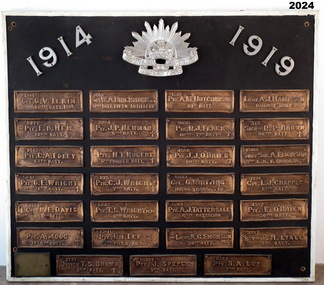
Honour Board - EAST BENDIGO PRIMARY SCHOOL HONOUR BOARD WW1, original plaques, post WW1
... NOK Father’s address: 99 Talbot St, Brunswick) 15. 5127 PTE. S.A. LOY 7TH BATT. (Samuel Arthur John Loy. Born in White Hills, Bendigo. ...NOK Father’s address: 99 Talbot St, Brunswick) 15. 5127 PTE. S.A. LOY 7TH BATT. (Samuel Arthur John Loy. Born in White Hills, Bendigo. ...The Bendigo East Primary School was opened in 1915. In 1916 it was decided to plant an ANZAC Avenue of trees and this was completed on 16 June 1916. The plaques were placed after WW1. The school was closed in 1998 and the plaques were relocated to the nearby White Hills Secondary College in Napier Street on this board. In the early 2000's the Honour Board was donated to what is now called the Bendigo Military Museum. One hundred years after planting, later in 2016 the trees were removed in controversial circumstances. On the board 8 never returned, there is 1 x "DCM" winner, 1 x "MC" winner and 1 x "MM" winner. There are 3 x Wright Brothers of which 2 never returned. The plaque states that the soldiers attended the school which is obvious they could not have due to the opening date. The following Heritage report suggests that the names were of individual soldiers who lived in the area. EXTRACT FROM HERITAGE COUNCIL VICTORIA 2016 SUBMISSIONS HEARING “The Bendigo East School (‘the school’) was officially opened by Mr Frank Tate, Director of Education, on 7 April 1916. Approximately two months later, on 16 June 1916, Arbor Day was celebrated at the school with the planting of an ‘Anzac Avenue’ along a path from the front gate on Strickland Road (‘the pathway’) to commemorate the landing of soldiers at Gallipoli. The school’s ‘Anzac Avenue’ was one of an estimated 37 known to have been planted by school children throughout Victoria during mid-1916 as part of a program led by the Education Department, which included a recommendation to schools on 18 May 1916 that commemorative avenues be planted (‘the 1916 plantings recommendation’). At around this time, avenues of honour were also planted across Victoria to commemorate fallen WWI soldiers (‘the wider commemorative plantings phenomenon’). There were other commemorative plantings at the Place away from the pathway (‘the other commemorative plantings’). Anzac Day was celebrated at the Place in the years subsequent to 1916 and on 11 December 1920 the school’s ‘Anzac Avenue’ was officially opened. Embossed copper plates, mounted on wood, were fixed in front of the trees in memory of individual soldiers from the district who had seen active service in WWI. There is evidence that as many as 32 plaques may have been made and affixed (‘the name plaques’). Plaques were removed from their locations at some stage before 1964, mounted on a board and displayed in the school building. These are now located and displayed at Bendigo Sub - Branch of the Returned Services League.” EAST BENDIGO HONOUR BOARD – COPPER PLAQUES (27 PLAQUES in total). 1. 2441 CPL G.V. LE KIM 60th BATT. M.M. (George Vincent LEE-KIM, born in Bendigo, Awarded Military Medal. RTA. NOK Father’s Address: C/- Strickland Rd, Bendigo). 2. 3821 PTE. E.B. HEM 20TH BATT. (Edward Bert Hem born in Bendigo. RTA. NOK Mother’s address: White Hills Post Office). 3. 3513 PTE. C.A. FOLEY 57th BATT. (Charles Albert Foley born in Bendigo. RTA. NOK Father’s address: Wilkie Street, Bendigo). 4. 5241 PTE. G. E. WRIGHT 6th BATT. † (George Edwin Wright born in Bendigo. KIA 8/12/1916. NOK Father’s address: 55 Charleston Rd. Bendigo). 5. 2663 L.CPL. N. E. DAVIS 60th BATT. (Norman Edward Davis born in Footscray. RTA. NOK Mother’s address: 193 Strickland Rd. Bendigo). 6. PTE. A. MOOG 16-6th BATT. † (5143 Adolph Moog born in Bendigo. Died of wounds received in action 8/12/1916, NOK Father’s address: Municipal Yards, Bendigo.) 7. 6515 SGT. W.A. BIRCHMORE DCM 11TH BATT. FIELD ARTILLERY (William Albert Birchmore born in Bendigo. Awarded DCM. RTA. NOK Mother’s address: Butler Street, California Gully) 8. 3924 PTE. J.P. NEWMAN 5TH BATT. † (392 (NAA) James Pausey Newman. Born in Bendigo. KIA 25/7/1916. NOK Father’s address Strickland Road, Bendigo) 9. 4865 PTE. H. T. NUGENT 5TH PIONEER BATT. † (also 4765 Hector Thomas Nugent born in Bendigo. KIA 26/11/1916. NOK Mother’s address: 55 Charleston Rd Bendigo). 10. 835 PTE. C.J. WRIGHT 7TH BATT. † (825(NAA) Charles Julian Wright. Born in Bendigo. KIA at Gallipoli 25/4/1915 NOK Father’s address 55 Charleston Rd Bendigo) 11. 5242 PTE. T.S. WRIGHT M.M. 6TH BATT. (Thomas Stanley Wright born in Bendigo. RTA. NOK Father’s address: 55 Charleston Road, Bendigo). 12. 13111 PTE. R.I. LEE 5TH FIELD AMBCE (19111 Robert Irwin Lee. Born in Kilcunda, Vic. RTA. NOK Wife’s address C/- Barnard Street, Bendigo) 13. 3731 DRIVER T.S. BROWN 5TH BATT.† (Thomas Sheridan Brown born in Bendigo. Died in the Field in France of Heart Failure. NOK Father’s address: Mundy Street, Bendigo). 14. 60999 PTE. J. SPENCE 5th BATT. (John Spence born in Bendigo. RTA. NOK Father’s address: 99 Talbot St, Brunswick) 15. 5127 PTE. S.A. LOY 7TH BATT. (Samuel Arthur John Loy. Born in White Hills, Bendigo. RTA Medical discharge. NOK Wife’s address C/- Hargreaves St Bendigo.) 16. 1649 PTE. A.M. HUTCHINSON 60TH BATT. (Alexander Morton Hutchison. (Note different spelling) born in Bendigo. RTA. NOK Mother’s address Wilkie Street, Bendigo). 17. 3035 PTE. R.J. FLACK 10TH – 7TH BATTs. † (Robert John Flack born in Bendigo. KIA France 17/8/1916. NOK Father’s address: Strickland Road, Bendigo). 18. 4558 PTE. J.J. O’BRIEN 60TH BATT.† (John James O’Brien born in Glenalbyn, Vic. KIA 28/9/1917. NOK Father’s address 68 Strickland Rd. Bendigo). 19. 5233 CPL. G. WHITTING MOTOR TRANSPT. COY. (George Whitting born in White Hills, Bendigo. RTA. NOK Mother’s address: 46 Baxter Street, Bendigo). 20. 5203 PTE. A.J. TATTERSALL 6TH BATTALION (Arthur James Tattersall born in Mandurang, Vic. RTA. NOK Wife’s address “Thornwell”, Bendigo East PO.) 21. 2ND LIEUT. K.G. EMONSON M.C. 38th BATT. (Keith Glanfield Emonson born in Sydney NSW. RTA – Medical discharge/ GSW head. NOK Father’s address: Strickland Road, Bendigo). 22. LIEUT. A.J. HAMPSON RAILWAY UNIT (Alfred John Hampson R/N 2300. Born in Bendigo. RTA. NOK wife’s address: 76 Addison St. Elwood, Vic). 23. 216 SIGNLR R.P. BROWN 38TH BATT † (Raymond Patrick Brown, born in Bendigo. KIA 28 May 1917. NOK. Mother’s address: 138 Mundy Street, Bendigo). 24. 15118 STAFF SGT. A. EMONSON 3RD L. H. F. AMBULANCE (Harry Allen Phipps Emonson born in Sydney NSW. RTA. NOK Father’s address Strickland Road, Bendigo, Vic). 25. 1724 CPL. L.J. CHAPPLE 5TH BATT. (Leslie John Chapple born in Bendigo. RTA. NOK Father’s address: Nolan Street, Bendigo) 26. 4557 PTE. E. O’BRIEN 60TH BATT. (Edward Charles O’ Brien, RTA. (NOK Father’s address: Strickland Rd, Bendigo). 27. 3557 SIGNLER F. H. LYALL 5TH BATT. (Francis Hubert Lyall born in Bendigo. RTA. NOK Father’s address: Strickland Rd, Bendigo). Honour Board, Bendigo East Primary School, timber backing with a white timber edging. At the top is a silver Rising Sun Badge with the dates in white "1914 & 1919". There are 27 bronze plaques, each has the Soldiers Regt Number, Name, Rank and Unit, for those that did not return there is a Cross added, if the Soldier won an award it is also added. At the bottom left hand corner is a brass plaque with details. Refer Aquisition for details. On the brass plaque, “These plaques were placed on the Avenue of trees at the school entrance on 20 December 1920. They were a memorial to those who enlisted from the Bendigo East School in the 1914 - 18 War. Mr R. J. Lee a Returned Soldier was Principal at this time”memorials-honour boards, military history-service records, metalcraft-bronze, east bendigo -
Federation University Historical Collection
Document, Zelda Martin, Central Victorian Goldmining towns - Boom Towns or Ghost Towns?, c1996
... Hill *Extracts from "The Golden Years of Stawell". Chapt 1 - Stawell's Coming Out. Capt. 2 - The Gold Rush. Caapt.3 - Cradle of Democracy. Chapt.4 - The Reefs Becomes Stawell. Chapt. 5 - Rushing In. Chapt.6 - The Pioneers. Chapt 7 - The Decade of Optimism. [.12] Resource No. 5: Blue Display Book titled 'Towns Steiglitz to the The Golden Triangle. Steiglitz: Brief History Victorian Post Office Directory 1869 *Map of Steiglitz *List of maps relevant to Steiglitz history *Information 6 tables of data from "Reports of Mining Surveyors Talbot...Hill *Extracts from "The Golden Years of Stawell". Chapt 1 - Stawell's Coming Out. Capt. 2 - The Gold Rush. Caapt.3 - Cradle of Democracy. Chapt.4 - The Reefs Becomes Stawell. Chapt. 5 - Rushing In. Chapt.6 - The Pioneers. Chapt 7 - The Decade of Optimism. [.12] Resource No. 5: Blue Display Book titled 'Towns Steiglitz to the The Golden Triangle. Steiglitz: Brief History Victorian Post Office Directory 1869 *Map of Steiglitz *List of maps relevant to Steiglitz history *Information 6 tables of data from "Reports of Mining Surveyors Talbot ...Zelda Martin was a PhD candidate at the University of Melbourne.[.1] 4th item in light blue display book titled Research Approach/Overview of Chapters/Confirmation of Canditure/Chapters1,2,3&4 of proposed thesis. *Twenty-seven page article on Victorian goldfields towns titled: Central Victorian Goldmining Towns - Boom Towns or Ghost Towns. The article was written during the author's PhD study. It outlines the context methodology, and resources and the chapters of the proposed thesis: (1) Central Victorian Goldmining Towns - The Context (2) Contemporary Views of the Factors Necessary for Town Growth (3) Outward Manifestations of Town Growth (4) The Trappings of Government (5-9) The Main Towns and Their Hinterland. [.2] 5th item in Light Blue display book as above item. *Chapter 1 of proposed thesis titled 'Pick, Shovel and Tin Dish Mining.' Covers in Section A: Central Victoria - Pre 1851: Aborigines in Central Victoria, Squatters, and Government. Section B: The years 1851-1854: The Early Gold Rushes, Government Reaction, Township Surveys, Legislation, Town Development, Local Government and Early Settlement. [.3] 6th item in Light Blue display book as above item. *2A of proposed thesis titled 'Contemporary Views of the Factors Necessary for Town Growth'. Similar information to Chapter 1 plus extra re towns and maps. Sections: Introduction, Context of Place - Geographical Towns Listed, The Context of Time - Pre1851 Aborigines, Governance of Port Phillip, The Squatters, The Villages of Central Victorian Highlands, Conclusion, Condensed Version of Chapter2B. [.4] 7th item in Light Blue display book as above item. *Chapter2B of proposed thesis. Sections: Area of Research, Schools, Banks, Newspapers, Progress Association, Town Development - Sandhurst (Bendigo), Ballarat, Castlemaine,, Maryborough, Ararat and Stawell. [.5] 8th item in Light Blue display book as above item. *Chapter 3 of proposed thesis titled 'Outward Manifestations of Town Growth'. Sections: Introduction, Contemporary Writing, Educationalists, The Bankers, The Townsfolk, Current Theory, General Theories of Urban Development, and Conclusion. [.6] 9th item in Light Blue display book as above item. *Chapter 4 of proposed thesis titled 'Trappings of Government' Sections: Introduction, Early Government Attitudes to Mining and Town Development, Law and Order, Township Surveys, Legislation, Local Government, Transport and Communication, The People and Lobbyists. [.7] 10th item in Light Blue display book as above item. *'The Rise and Fall of Central Victorian Goldmining Towns'. Includes a map showing main Goldfields, a table showing towns and villages at two points in time - 1857 and 1871; a Bibliography of Primary and Secondary Sources. [.8] Resource No1. Black display book titled Local Towns 1 : Alma: *Brief history *Directory *Maps Amphitheatre / Mountain Hut: *Brief History Post Office Directory Ararat: *Brief History *Post Office Directory 1869 - Alphabetical Listing by Occupation *Ararat - Prominent Citizens of 1858 *Langi-Morgala Museum Avoca: *Brief History *Excerpts from 'Avoca The Early Years', Margery and Betty Beavis; pg1 - Beginnings; pg11 - The Midas Touch; pg25 - Local Gold Escorts; pg27 - A Town is Born; pg51- The Administration of Justice; pg53 - The Ways of the Law; pg61 - News of the Day; pg65 - A Time to Play; pg72 - Land Ownership *Post Office Directory (Bailliere's) 1869 *Tourism Map and Information of area *Historic Avoca - A 5.5km Tour *Avoca & the Pyrenees Region - information pamphlet Ballarat: *Early History of Ballarat - Ballarat Historical Society, Publication No.1: origin of the name; Ballaarat - the Beginning; Fabulous Yields from the Ballaarat Goldfield; *Streetscape Lydiard Street. *Hand drawn map showing Leigh River, Old Portland Bay Road, plaque on road to Colac; etc. *Newspaper article re 'The Theatre Royal' ( which stood in the vicinity of the current Owen Williams store) - 'The News'15/04/1998 *Article - 'Ballarat's Mechanics' Institute Lives On' Ballarat Courier, 14/09/1985 *Article - Standing the Test of Time' The News 17/11/1993 re The Mechanics Institute & picture of the Reading Room *'Ballarat a Study of a City, Phyllis Reichl, pub. Nelson, 1968; no.3 place, time and people field studies series *Investigator Vol.33 No.2, 1998 Geelong Historical Society. Article on pg75 describes Ballarat in 1861 *Folded poster - 'Ballarat 100' a history of telegraph communication, pub. Telecom. Beaufort (Fiery Creek): *Brief history *Post Office Directory [.9] Resource No.2 Black Folder Titled Towns cont.No2 Bendigo (Sandhurst): *'Family & Local History at the Bendigo Library - 1851-2001 150 years of gold'. *Bendigo Government Camp in 1853 illustration; key to sketch and names of Government officers stationed there *Excerpts from 'Bendigo and Vicinity' Adolph Haman *The Bendigo Goldfield Registry - pgs 1-7 Introduction *Excerpt: 'Breaking the Grip' *Excerpt: The Most Go-Ahead Place *Excerpts from 'History of Bendigo' - anti license agitation; laying out of town; proposed railway; gold calls and dividends; the Sandhurst Municipality; journalism *Bibliography Blackwood: *Excerpts from 'Aspects of Early Blackwood - The Goldfield, the Landmarks, the Pioneers' Alan J Buckingham and Margaret F Hitchcock, JG Publishing,1980 Buninyong: *A Brief History *Investigator Vol1 No.2 Feb 1966 Geelong Historical Society. Pg3 - Article re gold escort route - Mt Alexander to Adelaide - (see a simple monument on the Western Highway a few miles out of Horsham. Pg 15 - Ballarat Excursion - re the finding of gold. *Three articles published by Buninyong and District Historical Society Inc: (Magpie Exploration; Finding Gold In The Green Hills; Magpie Exploration; Burnt Bridge to Cargarie to Mt Mercer) *Copies of newspaper articles/items *Buninyong Street Directory Carisbrook: *In the Beginning There Was Carisbrook *The History of the Carisbrook Racecourse Carngham / Snake Valley: *Brief History *Directory Castlemaine: *Directory 1865-1866 - Alphabetical and Street *Poster - Castlemaine A Contemporary Guide "The Great Centre" 1866 - A Contemporary Guide to the Fascinating Past *Pamphlet - Castlemaine District Community Hospital *Map - Castlemaine, Maldon & Surrounding Districts *Map and Information - The Dry Diggings Track - a 55kl walk among historic goldfields relics ( Castlemaine Fryerstown Vaughan Mt Franklin Hepburn Daylesford) *Postcard - Former Court House *Directory 1867 - Alphabetical, Trade [.10] Resource No.3 Grey folder Titled Towns 3 Creswick to Maryborough Creswick: *Brief History *Booklet - "Creswick Cemetery Walk" *Booklet - The Buried Rivers of Gold Heritage Trail Creswick *Creswick Historical Museum Information Sheet *Chronological History of Creswick *Alphabetical Directory of the Borough of Creswick *Creswick's Creek Directory 1856 *Historic Creswick Walking Tour *A Brief Account of the Schools of Creswick - Past and Present *100 Years of Railway Travel in Creswick *The Berry Deep Leads *The Spence Home at Jackass Gully in the Creswick State Forest ( William Guthrie Spence - Pioneer) *The New Australian Mine and the 1882 Disaster *Creswick District News, Issue 7, July August 1999 *The Creswick Miners Walk - Information and Map *Maps Chewton: *Brief History *Directory Clunes: *Brief History *Clunes Street Directory Daylesford: *Brief History *Notable Bushfires in Daylesford District Over More Than a Century - "Black Thursday" 1851; 1862; 1899; the Disastrous Hepburn Fire of 1906; 1939; 1944; 1969. *Post Office Directory -Daylesford and Hepburn Dunolly / Inkerman: *Brief History *Directory *Pamphlet - Goldfields Historical Museum *Pamphlet - Historic Dunolly - Victoria's Best Kept Secret *Map of Gold Workings at Dunolly Area - showing where the main gold rushes occurred *Brief History - Inglewood *Directory - Inglewood - Name Occupation, Dwelling Kingower: *Brief History *Directory - Name / Ocupation / Dwelling Linton / Happy Valley / Piggoreet: *Brief History *Directory - Lintons McIvor: *"A History of the Shire and the Township of Heathcote" by J.O. Randell Majorca: *Brief History *Official Post Office Directory 1869 - Name / Occupation/ Address Maldon (Tarrangower): *Brief History Part 1 *Brief History Part 2 *Post Office Directory *List - Alphabetical Order by Names plus Business and Trade (Tarrangower Times Oct/1858) *List - Alphabetical Order by Trade plus Name and Business *Directory - Name / Occupation / Dwelling Maryborough: *Worsley Cottage - built by Arthur Worsley, a contractor in stonework in 1894 [.11] Resource No. 4 Blue Display Book titled Towns 4 Moliagul to Stawell Moliagul: *Brief History *Moligul Legislative Assembly (Voting?) List - Names and Occupations *Moliagul Victorian Post Office Directory 1868 - Name / Ocupation / Address / Comments *"The Welcome Stranger" gold nugget *The Sunday School *The Welcome Stranger Discovery Walk - information and map Moonambel (Mountain Creek) Redbank *Brief History *List of names extracted from advertisments of the Pioneer and Mountain Creek Advertiser 16/02/1861. *Bailliere's Directory 1869 - Alphabetical List of Name / Occupation / Place St Arnaud: *Brief History Sebastapol: *Brief History *Directory 1869 - Alphabetical by Name; plus occupation and address. Browns and Scarsdale: *Brief History *Browns Street Directory - Name and Occupation Smythesdale: *Brief Description *Smythesdale Street Directory -Name and Occupation Stawell (Pleasant Creek) *Brief History *Victorian Official Post Office Directory - Name /Occupation / Dwelling *Chronology - 1841-1920 *Production of gold statistics - 1879 - 1900 *Big Hill *Extracts from "The Golden Years of Stawell". Chapt 1 - Stawell's Coming Out. Capt. 2 - The Gold Rush. Caapt.3 - Cradle of Democracy. Chapt.4 - The Reefs Becomes Stawell. Chapt. 5 - Rushing In. Chapt.6 - The Pioneers. Chapt 7 - The Decade of Optimism. [.12] Resource No. 5: Blue Display Book titled 'Towns Steiglitz to the The Golden Triangle. Steiglitz: Brief History Victorian Post Office Directory 1869 *Map of Steiglitz *List of maps relevant to Steiglitz history *Information 6 tables of data from "Reports of Mining Surveyors Talbot (Back Creek) Brief History Taradale: Post office Directory 1869 - Name/Occupation/Street. Also list in alphabetical order by Occupation Taradale *Chronological Reference to Taradale Mines *Water - The Coliban System of Waterworks *Joseph Brady *The Syphon Tarnagulla (Sandy Creek) *Brief History *Tarnagulla Businessmen Cameos to give depth to advertisments in 'The Tarnagulla Courier' various issues 1864-1871 *Directory - Name/Occupation /Address *List - Name/Business/Trade Wedderburn (Koorong) *Brief History *List - Name/Occupation The Golden Triangle: *The Early Rushes - Wedderburn / Moliagul / Sandy Creek - Tarnagulla / Jones Creek - Waanyarra / Kingower / Dunolly - Goldsborough / Inglweood *Census of 1857 - Population / Occupations *1858-1871 - A Time of Consolidation- Wedderburn / Moliagul / Sandy Creek- Tarnagulla / Arnold *Census 1871 - Population *Information gleaned from the census data - Demographics / Population / Occupations / marital / Birthplace / Religion / Literacy/ Occupation and Housing Cameos *Graphs - Birthplace of settlers /Male-Female Ratio / Married males / Children under 15 as Percentage of Population / Religion *Census 1857 - Statistical data *Maps *Bibliography [.13] Resource No. 6 - Black Display Book Information and Research in Central Victoria including: *Banking - Research from ANZ Bank Archives *Institutions - also includes articles listed from the Ballarat Times Newspaper *Australian mining History Association - A.M.H.A. Bibliography *Australia's Mining History * Bibliography - Land Surveys Victoria - *1853 Administration (Statistics and Other) includes: schools / ministers of religion / police / military / local administration / licences for sale of spirits / distances between various Victorian gold fields. * Victoria Government Gazette (Copy) - N0. 116, 12/12/1854 includes: Gold Felds Commission of Enquiry & No. 85, 15/09/1854 - Addresses presented to the Lieutenant Governor (Sir Charles Hotham) during his tour through the Gold Fields of Victoria,1854. Addresses on behalf of : the people of Bendigo; Members of the Church of England, Bendigo; Members of the Wesleyan Church on the Bendigo Gold Fields; Bendigo Gold District General Hospital; the Bendigo Prospecting Association; Committee of the Bendigo Local Exhibition; Bendigo District Medical Association; Coloured Americans Resident at Bendigo; German Inhabitants of Bendigo; Landowners, Inhabitants, and Miners of Castlemaine; Inhabitants of Forest Creek; Inhabitants of Heathcote and Gold Miners of McIvor; Residents and landholders of the District of Bacchus Marsh; Inhabitants of Kilmore and Vicinity. *Gold Fields Correspondence 1853: letter from Lieutenant Colonel Valiant, (Officer commanding the Troops in Victoria) to the Lieutenant Governor re threatened disturbance at Sandhurst (Bendigo) regarding the Gold License Fee. * Extracts from a book "Victoria" re Gold Fields Commission of Enquiry involving mainly Ballarat and Castlemaine and a chapter titled 'A Tour to the Victorian Gold-Fields' *Lists of central Victorian newspapers - listed by date published 1851to 1874; by first date available to State Library. *A list of cities and towns showing County, population in 1861 &1871, and municipal status. [.14] Resource no.7. Black display book. *Reference: Papers presented to Parliament Victoria - 1859-1860 4 volumes - relevant sections copied. Contains information on Branches of Government. General / Finance / Gold / Gazette / Commission and Warrant / Statistic. *Gold Fields Act. In accordance with the Act the gold fields are divided into six districts - Ballaarat, Castlemaine , Sandhurst, Avoca, Ararat, and Beechworth.. Official staff in each gold district consists of a Resident Warden, Wardens, Wardens' Clerks, Bailiffs, Chinese Protectors, Chinese Interpreters, and Mining Surveyors. *Gold Receiver *Gaols *Police magistrates and Clerks of Petty Sessions, etc. *Field Branch *Immigration and Emigration Overland - Chinese - 1859 *Population on the Goldfields *The Geological Survey - The Government Geologist is assisited by staff from four branches - the office Branch; the Publishing Branch; the Field Branch and the Museum Branch. *Commission to Enquire Into Sludge dated 10/02/1859 (Some sections copied) - Report to the Honorable Chief Commissioner of Public Works, Melbourne re the mode of carrying the sludge from the puddling mills in Sandhurst without interfering with the drainage of the town and the roads in the neighbourhood. [.15] Resource No.8: Camel display book titled Resource No. 8. Aborigines *Lists of book titles - +"Readings in Victorian prehistory" +"The Aborigines of Port Phillip" +Aboriginal languages and clans" +"A History of the Port Phillip District" +"Langi Ghiran 1: Aboriginal Rock...." +"Koorie History: sources for aboriginal studies in the State Library of Victoria", ed. Tom Griffiths, Melb. Friends of the State Library, 1989 +"The Public Lands of Australia Felix"; settlement and land appraisal in Victoria1834-91 with special reference to the Western Plains", J.M.Powell, Melb. Oxford University Press 1970 +*Bibliography of the Victorian Aborigines' from the earliest manuscripts to 31st December 1970, Massoa, Aldo, Melb. Hawthorn Press, 1971 +"Aborigines in Colonial Victoria, 1836-1886", M.F. Christie, Sydney University Press, 1979 +"Urban and Industrial Australia: readings in Human Geography" ed J.M. Powell, Melb. Sorrett Pub. 1974 *Extracts: -Processes of Pioneer Settlement - The Squatting Occupation of Victoria, 1834-60. J.M. Powell -Areal Variations in the Class Structure of the Central-Place Hierarchy. P. Scott - Volume1 and Volume 2: Notes Relating to the Habits of the Natives of Other Parts of Australia and Tasmania. Compiled from various sources for the Government of Victoria by R Brough Smyth. John Curry, O'Neil, Melb. 1st pub. Melb. 1876. p31-45 - Numbers and Distribution of the Aborigines in Victoria -Victorian Aborigines 1835-1901 - A Resource Guide to the Holdings of the Public Record Office, Victoria; published by the Government Information Centre 1984. *History of the Aboriginal Artefacts Displayed in the Daylesford Museum. F. G. Powell (4 page pamphlet) *Letter to Zelda Martin from Peter Lovett, Cultural Officer, Ballarat & District Aboriginal Co- Operative, 05/02/1997 *Map: Ian Clarke Victorian Tribunal Boundary Map - Clans of Central Victoria. *Victorian Rock Art and Mythology - Article about Mount Langhi Ghiran and myths of the Tjapwarong people. *Two Aboriginal myths relating to the Grampians - 'The Monster Emu' / 'The Aquisition of Fire', by the Aborigines in the Grampians Areas *Article titled (chapter 8) Ballarat - information re camping sites in the region. Lake Wendouree / Lake Burrumbeet (includes a myth) / Mt Bunninyong / Lal Lal / Pitfield / Mount Elephant / Mount Egerton / Meredith / Lake Goldsmith / Lake Learmonth / Ercildoune *Notes on the Aborigines of the Wider Ballarat Region plus European names=Aboriginal names. John Morris 26/07/1995 *Role of Aborigines in Town Development in Central Victoria. Mentions Native Police Force est. in Port Phillip 1842 and Central Board for Aborigines est. 1860 *The Grave of King Billy. (Frank Wilson) Pamphlet. *Camping Places in Central and Northern Victoria. Article re Lake Burrumbeet site. *Programme for the Unveiling of Memorial Cairn for Edward Stone Parker 1802-1865. Note portrait not accurate. Accurate portrait is available in the book "A Successful Failure A Trilogy The Aborigines and Early Settlers", Edgar Morrison, Graffiti Publications, 2002. * Large envelope addressed to Mr G Netherway containing newspaper cuttings regarding the life of Edward Stone Parker, the unveiling of the Memorial Cairn as mentioned above, articles titled 'Episodes from Our Early Days' (Edgar Morrison, Yandoit)- The Black's School, A School At Last and The Final years. Also a typed page titled 'Historical Background to E.S.Parker's Career. Includes an interesting tale titled 'When the cat lay doggo' re laying power leads for the unveiling ceremony at the memorial site. [.16] green display folder titled 'Research Aids' *List of references to Commissioners' & W'ardens' Reports (formerly held at La Trobe Library Archives, now at Public Records Office [PRO]). Indicates town referred to / date of report / name of camp if different to town. * Archive information re Anglican Records *Movement around the Goldfields - Miners and Storekeepers - usefulness of newspapers in providing information - areas covered - Castlemaine, Maldon, Ararat, Stawell, Tarnagulla, Dunolly. *Port Phillip /Victoria Directories 1839/1867 - Chronological list of Directories included in this series. *"Notes on the History of Local Government in Victoria" A.W. Greig Melb. University Press 1925 - Photo-copied extract p5-p40. (Source - Deakin University Library) - Introduction by W.Harrison Moore. Section 1 - Development in New South Wales Before Separation. Section 2 - Development in Victoria After Its Separation from New South Wales. Hand written notations: 'roads, markets, and local government 1855 on' ;'opportunity of squatters in parliament' and 'opportunities of matters in parliament p33' * Notes on the Establishment of Surveyor General's Department 1851and Commissioner of Crown Lands and Survey. * Newspaper articles from The Argus, 1849, re the discovery of gold in the Pyrenees region. * Excerpt - a report on schools - A.B.Orlebar, Inspector; re the need for permanent school buildings rather than tents. *Excerpt from - 'Approaches to Urban History', Sean Glynn: The Case for Caution * Except from - 'The Urban Sprinkle', Weston Bate: Country Towns and Australian Regional History *Reference- 'The History of Land Tenure in the Colony of Victoria', John Quick. References the Haines Land Bill, land tenure and Land Leagues. [.17] Light blue envelope folder titled 'Birtchnell's Ballarat, etc. Directory 1862 *Contains various directories for Smythesdale, Buninyong, Clunes, Brown's and Creswick. [.18] Red envelope folder no.2 titled Victorian Gazetteer *Selected pages from 1869 Victorian Gazetteer on A4 paper (with a handwritten note questioning if some pages are from 1868 Victorian Gazetteer as appears to be different sizes - A3 pages.) Information includes locations and descriptions of towns, hotels, banks, communications and populations. (Does not include names, residences and occupations) [.19] Red Envelope folder titled Bailliere's Official Post Office Directory 1868 (or1869 or a mixture of both?) *Preface *Contains a selection of pages of towns highlighted in yellow in the the index *Work on this directory was commenced in 1867. *Information includes: Municipalities - mayors and councilors; lists of towns naming male inhabitants and their occupations. [.20]Yellow manila folder titled Post Grad Seminar Presentation 1996 *Gives some background to Zelda Martin's proposed thesis and why she chose the topic Gold Mining Towns Boom or Bust [.21] A3 display book - No. 1A * A list of 'Relevant Newspapers collected: The Tarrangower Times and Maldon Advertiser (first published 1858) Includes dates 1858-1867. The Mount Alexander Mail. Includes dates 1854-1866 The Tarnagulla Courier. Includes dates from1864-1871 Dunolly and Burnt Creek Express. Includes dates from 1862-1871 * Selection of newspaper pages from The Mount Alexander Mail 1854 to 1856, mostly showing advertisements for businesses and services provided to that community. [.22] A3 display book - No. 1B * Selection of newspaper pages from The Mount Alexander Mail 1857 to 1866, mostly showing advertisements for businesses and services provided to that community. [.23] A3 display book -No. 2 * Selection of newspaper pages from The Tarnagulla Courier 1864 to 1871, mostly showing advertisements for businesses and services provided to that community. [.24] A3 display book - No. 3 *Selection of newspaper pages from The Tarrangower Times (and Maldon and Newstead) Advertiser 1858 to1867, mostly showing advertisements for businesses and services provided to that community. [.25] A3 display book - No.4 * Selection of newspaper pages from The Dunolly and Burnt Creek Express; and The Dunolly and Betbetshire Express 1862 to 1871, mostly showing advertisements for businesses and services provided for that community. [.26] A3 display book - No.5 Includes: * Bryce Ross's Diggings Directory. Includes instructions for using this directory. This directory was used by "all persons having connexion or desiring to communicate with 'working parties, private friends, or Stores at the Diggings." As a directory for each area wwas completed it was published in each month's issue of Bonwick's "Digger's Magazine." Years c1852/1853. This Directory commences first at the head of Forest Creek. Includes a directory for Bendigo and Ballarat. Of interest at the end of the Bendigo and Ballarat directory is a list of the number of storekeepers, butchers, doctors, smiths, eating houses, lemonade sellers and chapels. * The Castlemaine Directory and Book of General Information Comprehending Glass's Model Calendar for the Two Years 1862 and1863. "zelda martin, victorian goldfield towns, bendigo, castlemaine, ballarat, maldon, stawell, ararat, maryborough, creswick, avoca, heathcote, banks, bank of australasia, union bank of australia, government camp, sandhurst, water supply, tarnagulla, talbot, back creek, mountain creek, police court, carisbrook, dunolly, thompson's foundry, charles clacy, anthony trollope, robert cecil, mount alexander, urbanisation, national schools, education, govenrment, industry, railway, transport, settlement, land settlement in central victoria, steiglitz, joseph brady, the new australian mine, berry deep leads, william guthrie spence, creswick state forest, arthur worsley, worsley cottage, the welcome stranger, moliagul, moonambel, redbank, st arnaud, sebastapol, brown's, scarsdale, clunes, chewton, daylesford, bushfires, inkerman, inglewood, kingower, lintons, happy valley, piggoreet, mcivor, majorca, tarrangower, taradale, the coliban system, the syphon, sandy creek, wedderburn, koorong, arnold, jones creek, waanyarra, the golden triangle, census 1857, blackwood, buninyong, durham lead, magpie, carngham, snake valley, alma, amherst, daisy hill, amphitheatre, mountain hut, beaufort, fiery creek, counties, population, gold fields commission of enquiry1854, william westgarth, gold license fee, lieutenant colonel valiant, administration of the victorian gold fields, commission to enquire into sludge 1859, e.s. parker, edward stone parker, edgar morrison, mount franklin protectorate, dja dja wurrung, memorial cairn, franklinford, mt franklin memorial cairn, jajowurrong, dja dja wurung, tjaowarong, wothowurong, assistant protectors, daylesford museum, buluk, rock art - grampians, aboriginal mythology - grampians, aborigines, first nations people, mount franklin, aboriginal artifacts, lake burrumbeet, native police force, central board of aborigines, yandoit, commissioners' reports, wardens' reports, port phillip/victoria directories 1839-1867, local government - victoria 1853/1854, surveyor general's department - 1850's, victorian schools 1850's, a.b.orlebar, haines land bill, william charles haines, wilson gray, land tenure, land leagues, victorian gazetteer, the tarrangower times and maldon advertiser - 1858-1867, the mount alexander mail 1854-1866, the tarnagulla courier 1864, dunolly and burnt creek express 1862-1871, bryce rose's diggings directory, the castlemaine directory 1862-1863 -
 Federation University Historical Collection
Letter, Letters written by Richard Squire to his son Tom Squire 1938
... Talbot Alluvials...Guildford Plateau...A.B.C. Special Supply Store...Geological Branch...Shell Coy...Lawaluk...Almanac...McBinny...Bingley's Paddock...Cargaire Valley and Lead...Stand and Deliver Demands...Sheehan's...Smeaton Hotel...John Charleson...Ballarat Main Lead...Goon...Dereel...The Bay Leads...Avoca Field...Ballarat Alluvials...Haddon Field...Courier...School of Mines...Bewick Mining & Co....Broken Hill...Talbot Alluvials Guildford Plateau A.B.C. Special Supply Store Geological Branch Shell Coy Lawaluk Almanac McBinny Bingley's Paddock Cargaire Valley and Lead Stand and Deliver Demands Sheehan's Smeaton Hotel John Charleson Ballarat Main Lead Goon Dereel The Bay Leads Avoca Field Ballarat Alluvials Haddon Field Courier School of Mines Bewick Mining & Co. Broken Hill ...In 1905 Richard Squire was manager of the West Berry Consols at Allendale, and developed an improved system of mine ventilation, which was supported in "The Age."[4] He was successful in combating and remedying the gas and ventilation troubles of the Deep Mines of Creswick and Allendale Districts after all had failed. MINE MANAGERS’ ASSOCIATION. Ballarat Branch. ... Mr R. B. Squire, manager of the West Berry Consols, at Allendale, submitted a paper detailing what he had done tor the betterment of ventilation in the alluvial mines of Smeaton and Mary borough districts- Members gave Mr Squire every credit for the results that he claimed to have effected; the adoption of his ideas had testified to their value to mine-owners. It was painted out, however, that for want of a thorough debate of the subject with experienced men the author had unwittingly included some general statements that required modifying in some points and extending in others, in justice to other workers among the earlier and the present day managers of mines. It was decided to invite the author to meet a sub-committee on this subjectHandwritten letters written by Richard Squire to his son Tom Squire 1938 on lined paperrichard squire, tom squire, hazel squire, jack squire, jim squire, ned, mt mercer, plant, skids, pump, poppet, carburetor, shaft, balance weight, pulleys, syndicate, suction, lease, reports, estimates, flat fields, reef, trucks, pipeclay, sandstone, suction pipe, valves, honeycomb rock, yarrowee, ballarat, reef combs, cheques, yellow slate, leigh river, dyke, quartz, ballarat deep leads, ballarat deep leads extension, bore, reads, bedrock, cemented sand, g m of a, gold mines of australia, liz the car, geoff squire, lode, hayes timber, ethel, ross creek field, ross creek gold mining co., frank herman, lillas, jack hayes, eyres brothers, g.gay & co, buninyong, glenfine, the star mine of avoca fields, talbot alluvials, guildford plateau, a.b.c. special supply store, geological branch, shell coy, lawaluk, almanac, mcbinny, bingley's paddock, cargaire valley and lead, stand and deliver demands, sheehan's, smeaton hotel, john charleson, ballarat main lead, goon, dereel, the bay leads, avoca field, ballarat alluvials, haddon field, courier, school of mines, bewick mining & co., broken hill syndicate, morrison's lead, baragwanath, creswick, duke of wellington plant, the moorabool lead, kohinoor band and alluvian, star of the east, bonshaw, epidemic, polio, k.w. steedman, mr newman, allendale mines, professor mica smith, alfred mica smith, mr hodge, w. taylor, mcpherson's reward coy, mr mitchell, billy thomas, john bull, albert, nina, stanley hunter, frederick the great, ross creek south, bislolo, brilolo, birlolo, ballarat east coy, maxwells, reginald murray, bob allan, vendetta, john lynch, dodson, mnster of mines, e.j. hogan, jonah ward, mcnaughton's paddock, bellesby, alec peacock, jenkins, h.c. jenkins, conspiracy, argus, mr ellerby, dr lawrence, occulist, mining -
 Federation University Historical Collection
Document, Transfer of Ownership of Prospecting Quartz Claim, under a Grant from the Ballarat Mining Board, 6 February 1860, 1860
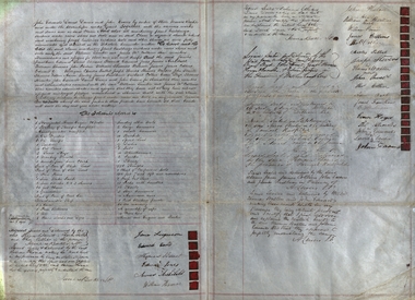
... Hill near Creswick, Victoria. This ownership transfer was between Misters Ferguson and others to Misters Lamble and McCallum. Each person mentioned signed the document. All machinery and parts thereof are listed, plus any buildings, tools, blacksmith's shop and tools, ropes and paints/tar, etc james ferguson edward david thomas barnett edward jones james archibald john phelan william innis james collins dick collier charles talbot joseph stevens x (his mark) william thomas x (his mark) thomas walters john powell thomas collier a bach e milligan thomas knowles x (his mark) john edwards x (his mark) david davies john evans william lamble james mccallum james faulkner evan sloyd Signatures of owners. ...Document outlining the change of ownership of a Quartz Claim, all machinery and buildings at Spring Hill near Creswick, Victoria. This ownership transfer was between Misters Ferguson and others to Misters Lamble and McCallum. Each person mentioned signed the document. All machinery and parts thereof are listed, plus any buildings, tools, blacksmith's shop and tools, ropes and paints/tar, etcLarge cream coloured thick paper, Hand written in black ink. Twenty-four seals Signatures of owners.james ferguson, edward david, thomas barnett, edward jones, james archibald, john phelan, william innis, james collins, dick collier, charles talbot, joseph stevens, x (his mark) william thomas, x (his mark) thomas walters, john powell, thomas collier, a bach, e milligan, thomas knowles, x (his mark) john edwards, x (his mark) david davies, john evans, william lamble, james mccallum, james faulkner, evan sloyd -
Glen Eira Historical Society
Book - CAULFIELD CENTENARY 1957
... Hill... Market gardens... Dairies... Lady Talbot...Loyd Charles du Plan Hope George ‘Airdrie’ Kooyong Hill Market gardens Dairies Lady Talbot milk supply Jenner family O’Niell College Presentation Sisters Glenferrie Road Grimwade Frederick Sheppard Grimwade Alice ‘Harlston’ Grimwade House ‘Saint Aubin’s’ ‘St. ...This file contains four items 1/Two copies of a twenty-four page booklet titled CITY OF CAULFIELD CENTENARY 1857-1957, created by the Caulfield City Council and printed by Peter Isaacson Pty Limited, Melbourne. The booklet details important aspects of Caulfield’s history including council procedures, the Caulfield Road District Proclamation, the first election and a summary of 100 years of local government with a description of the present Caulfield in 1957. The booklet also includes several pictures of various Caulfield landmarks and people including one of Caulfield City Councillors (11 men and 1 woman). Also one photocopied version of this booklet. 2/Eleven pages of typed notes for the City of Caulfield Centenary booklet. All notes are undated and incomplete. Two pages titled NOTES on THE HISTORY and PROGRESS OF THE CITY OF CAULFIELD, author unknown. Three and a half pages titled THE STRUCTURE OF LOCAL GOVERNMENT IN VICTORIA, author unknown. Five pages titled 100 YEARS OF LOCAL GOVERNMENT – EARLY CAULFIELD, by Mrs A. P. Bell. 3/A typed letter to Miss V. Webb-Langdon from the Town Clerk H.G. Nelson, acknowledging her contribution to historical details for the Caulfield Council’s Centenary booklet, dated 24/12/1957. 4/A handwritten letter and a handwritten note regarding the acquisition of notes for the Caulfield Centenary booklet. The letter is dated 03/08/2006 and the note is dated 09/02/2007.city of caulfield centenary, caulfield road district, sinclair a.j.g., city hall, war memorials, gamble h.a., machin l.r., bunny f.c.d., caulfield park, koornang reserve, parton e.m., sims h.e., thomson w.r., gunn e.e., yorston j.s., wallace g.e. mrs, green w.c., jenner e.r., ward boundaries, dandenong road, queens avenue, normanby road, station street, bond street, glen eira road, orrong road, poath road, north road, booran road, nepean highway, glen huntly road, glenhuntly road, inkerman road, hotham street, nelson h.g., fullard w.r., mackley g.j., ellis k.i, crosbie m.r., nutting b.i., body j.h., pritchard r.j., guildford l.t.g., lund l.m., street h.c., reynolds a.w., elections , political processes, local government, springthorpe reserve, greenmeadows gardens, business and finance, roads and streets, caulfield racecourse, east caulfield reserve, mackinnon reserve, hawthorn road, balaclava road, murrumbeena road, lempriere avenue, victoria street, koornang road, lord reserve, lyons street, murrumbeena reserve, kangaroo road, ormond park, beatty crescent, foch street, packer reserve, oakleigh road, leila road, prices park, bambra road, riley reserve, playgrounds, town hall, maternal and child health centres, truganini road, grange road, senior citizens centre, barkley sir henry, moore david, handasyde gilbert, caulfield school room, harris g.w., semple john, dempsey william, brooks w.a., wilson thomas, lyall william, murrum murrumbeen lifestyle, ‘greenmeadows’ house, lempriere family, aboriginal culture, ‘rippon lea’ house, caulfield john, ‘slaney’s’ home, alma road, paddy’s swamp, racecourse hotel, caulfield technical college, bevan mr., ‘grosmont’, hart john, railways, mansions, ‘rosecraddock’, langdon h. j., caulfield cup, ‘crotonhurst’, webb judge, ‘kilwinning’, service james, ricketson henry, ‘glen eira’, house names, garden vale, ross william murray, ‘ross’s folly’, outer circle railway, caulfield grammar school, davies j. henry, lagdon william, grimwade f.s., loyd charles du plan, hope george, ‘airdrie’, kooyong hill, market gardens, dairies, lady talbot milk supply, jenner family, o’niell college, presentation sisters, glenferrie road, grimwade frederick sheppard, grimwade alice, ‘harlston’, grimwade house, ‘saint aubin’s’, ‘st. aubin’s’, ‘caulfield hall’, caulfield john p.t., st georges road, caulfield military hospital, nursing homes, health establishments, dover street, sports and recreations, rosanna street, ‘cantala’, health services, parks and reserves, community services, town planning, local government finance, local officials and employees -
 Eltham District Historical Society Inc
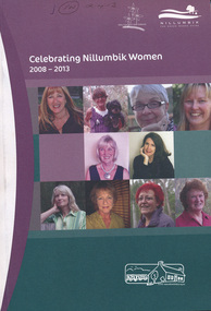
Book, Nillumbik Shire Council, Celebrating Nillumbik Women 2008-2013, 2013
... The 2008 nominations are: Wendy Alexander, Jane Ashton, Sharon Banner, Janet Boddy, Catherine Cervasio, Belinda Clarkson, Helen Coleman, Cathy Dean, Judy Duffy, Gwen Ford, Jenny Graves, Cath Giles, Meera Govil, Ona Henderson, Jill Jameson, Vicki Kaye, Mrs Kimber, Nerida Kirov, Jane Lauber, Pam Lawson, Anne Manne, Chris Marks, Elizabeth Marshall, Dawn McDonnell, Jenny Millar, Grace Mitchell, Jenni Mitchell, Michelle Molinaro, Joy Murphy, Rosie Murphy, Barbara Murray, Tracey Naughton, Josephine Norman, Pamela Pederson, Mary Robertson, Vicki Ruhr, Geraldine Sanderson, Dawn Shaw, Fiona Sievers, Myra Skipper, Selina Sutherland, Barbara Talbot, Marjorie Taylor, Julie Tipene-O’Toole, Susie Walker, Donna Zander. 2009: Jan Aitken, Rosemary Aitken – OAM, Edith Apted, Betty Anderson, Thelma Barkway, Diana Bassett-Smith, Jenneke Bateman-Korteweg, Amy Bryans, Sabi Buehler, Jenni Bundy, Audrey Cahn, Linda Cornelissen, Janice Crosswhite, Elean Dansey, Christine Durham Claire Fitzpatrick, Ailsa Fitzmaurice, Lucinda Flynn, Sheryl Garbutt MP, Fran Gronow, Ev Hales, Irene “Rennie” Harrison, Ena Jarvis, Heather Kaufmann. 1948-2007: Helen Kenney, Margot Knox – Pederson, Lois Loftus-Hills, Nina Mikhailovna Christesen AM (nee Maximov), Penny Mullinar, Gwayne Naug, Nanette Oates, Lisal O’Brien, Stella Reid, Laura Rohricht, Meg Russell, Sonia Skipper, Bronwyn South, Pauline Toner MP, Lisa Walton, Diana Warrell, Rachel Watt. ...The 2008 nominations are: Wendy Alexander, Jane Ashton, Sharon Banner, Janet Boddy, Catherine Cervasio, Belinda Clarkson, Helen Coleman, Cathy Dean, Judy Duffy, Gwen Ford, Jenny Graves, Cath Giles, Meera Govil, Ona Henderson, Jill Jameson, Vicki Kaye, Mrs Kimber, Nerida Kirov, Jane Lauber, Pam Lawson, Anne Manne, Chris Marks, Elizabeth Marshall, Dawn McDonnell, Jenny Millar, Grace Mitchell, Jenni Mitchell, Michelle Molinaro, Joy Murphy, Rosie Murphy, Barbara Murray, Tracey Naughton, Josephine Norman, Pamela Pederson, Mary Robertson, Vicki Ruhr, Geraldine Sanderson, Dawn Shaw, Fiona Sievers, Myra Skipper, Selina Sutherland, Barbara Talbot, Marjorie Taylor, Julie Tipene-O’Toole, Susie Walker, Donna Zander. 2009: Jan Aitken, Rosemary Aitken – OAM, Edith Apted, Betty Anderson, Thelma Barkway, Diana Bassett-Smith, Jenneke Bateman-Korteweg, Amy Bryans, Sabi Buehler, Jenni Bundy, Audrey Cahn, Linda Cornelissen, Janice Crosswhite, Elean Dansey, Christine Durham Claire Fitzpatrick, Ailsa Fitzmaurice, Lucinda Flynn, Sheryl Garbutt MP, Fran Gronow, Ev Hales, Irene “Rennie” Harrison, Ena Jarvis, Heather Kaufmann. 1948-2007: Helen Kenney, Margot Knox – Pederson, Lois Loftus-Hills, Nina Mikhailovna Christesen AM (nee Maximov), Penny Mullinar, Gwayne Naug, Nanette Oates, Lisal O’Brien, Stella Reid, Laura Rohricht, Meg Russell, Sonia Skipper, Bronwyn South, Pauline Toner MP, Lisa Walton, Diana Warrell, Rachel Watt. ...This book was conceived by the Nillumbik Women's Network as a way of writing women into local history. When seeking nominations for the 2010 editon, the press release stated: Nillumbik Shire’s official histories don’t reflect the important but often unacknowledged contribution of local women to the development of the area. To redress this, the Nillumbik Women’s Network (NWN) initiated a small project, Celebrating Nillumbik women in late 2007.( For details of the Nillumbik Women’s Network refer to attachment) The NWN sought nominations of local women who had made, or continue to make, a significant contribution to the social and cultural life of our community. The brief profiles of the nominees were published in a booklet, which was launched at an International Women’s Day celebration in March 2008, and a second publication was produced in 2009. We continue to be inspired by the quality and activism of our local women. Many of the biographies tell of women’s contribution to the building of the ‘social’ infrastructure of the Shire. These stories complement the official historical accounts which primarily document men’s role in building the physical infrastructure of the Shire. One begins to develop a clearer picture of how women went about developing the services which we take for granted today, from the small kindergartens operating out of church halls to the wide ranging network of occasional and long day childcare care to the development of home based services for older frail and disabled residents of the area. They also tell of the bravery and resilience of women in their response to the devastating impact of the Black Saturday bushfires. This volume includes profiles of 23 women, 2013 Nominees in addition to those included since the project was launched in 2008. The 2008 nominations are: Wendy Alexander, Jane Ashton, Sharon Banner, Janet Boddy, Catherine Cervasio, Belinda Clarkson, Helen Coleman, Cathy Dean, Judy Duffy, Gwen Ford, Jenny Graves, Cath Giles, Meera Govil, Ona Henderson, Jill Jameson, Vicki Kaye, Mrs Kimber, Nerida Kirov, Jane Lauber, Pam Lawson, Anne Manne, Chris Marks, Elizabeth Marshall, Dawn McDonnell, Jenny Millar, Grace Mitchell, Jenni Mitchell, Michelle Molinaro, Joy Murphy, Rosie Murphy, Barbara Murray, Tracey Naughton, Josephine Norman, Pamela Pederson, Mary Robertson, Vicki Ruhr, Geraldine Sanderson, Dawn Shaw, Fiona Sievers, Myra Skipper, Selina Sutherland, Barbara Talbot, Marjorie Taylor, Julie Tipene-O’Toole, Susie Walker, Donna Zander. 2009: Jan Aitken, Rosemary Aitken – OAM, Edith Apted, Betty Anderson, Thelma Barkway, Diana Bassett-Smith, Jenneke Bateman-Korteweg, Amy Bryans, Sabi Buehler, Jenni Bundy, Audrey Cahn, Linda Cornelissen, Janice Crosswhite, Elean Dansey, Christine Durham Claire Fitzpatrick, Ailsa Fitzmaurice, Lucinda Flynn, Sheryl Garbutt MP, Fran Gronow, Ev Hales, Irene “Rennie” Harrison, Ena Jarvis, Heather Kaufmann. 1948-2007: Helen Kenney, Margot Knox – Pederson, Lois Loftus-Hills, Nina Mikhailovna Christesen AM (nee Maximov), Penny Mullinar, Gwayne Naug, Nanette Oates, Lisal O’Brien, Stella Reid, Laura Rohricht, Meg Russell, Sonia Skipper, Bronwyn South, Pauline Toner MP, Lisa Walton, Diana Warrell, Rachel Watt. The 2013 nominations are: Roslyn Addison, Sue Aldred, Lucy Anderson, Sue Arnold, Mary Avola, Anna Foletta, Morag Fraser, Danielle Green MP, Colleen Hackett, Pam Hayes, Barbara Joyce, Carol Leeson, Sandra and Bruce Poloni, Many Press, Carolyn Royse, Hannah Sky, Lorna Smith, Lynlee Tozer, Kilanthi Vassiliadis, Kerry Wailes, Gale Weiss, Irma Winton and Alexis Wright.This book is a significant in the recording of the contribution of local women to the development of the Shire of Nillumbik, especially for the time frame 2008 -- 2013. Historically women's stories generally have not been told at all, let alone their contributions acknowledged. This book profiles and documents women's stories that otherwise may not have been told.women, nillumbik women's network -
 Bendigo Historical Society Inc.
Document - BENDIGO SALEYARDS COLLECTION: THE BENDIGO SALEYARDS ECONOMIC VIABILITY STUDY
... Hill M J & Co... Bennetts Meats... Comell Bros... Davis B & D... Hardwick G F & V C... Penney & Lang P/L... Tendercut Meats... Northern Seed Supply Co... Bendigo Fertilizers... Agri Business Pty Ltd... Agrilink Consulting Group Pty Ltd... Acil Aust Pty Ltd... McGowan & Associates... Chapman W C... Talbot...Kate Millard Loddon Campaspe Planning Authority Street Ryan and Associates Bendigo City Council Strathfieldsaye Shire Council Department of Industry Technology & Resources National Library of Australia Meldrum Burows & Partners Core Wilson Sayer Town Planning Appeals Panel CES Victorian Farmers and Graziers Association Stock Agents Association Department of Agriculture Department of Industry Technology & Resources Department of Conservation Forests and Land Cr Jock Comini RCA Depot Wellsford Rifle Range Bendigo Airport Bendigo Field Naturalists Club Mr David Kennedy Mr John Brumby Mr John Radford Neil O'Keefe Bendigo East Progress Association Bendigo East Traders Trades Hall Council Mr Tom Uren Mr Frank Wilkes Mr Bruce Reid Mr K I M Wright Mr E T Ebery Bendigo Pastoral Council of the VFGA Victorian Meatworks Association Bendigo Stock & Station Agents Association Rutlands Transport Mr Don Pickles Country Abattoirs & Wholesalers Association Association of Victoria Meat and Allied Trade Federation of Australia Bendigo Saleyards Advisory Committee Bendigo Residents & Ratepayers Association A H & N Graham Mrs P Unmack Australian Bureau of Statistics Mr Lloyd Houlden Cr C Rodda Mr Jolly Mr Tony Milanese Dr Robert Carter University of Melbourne Bendigo College of TAFE T Matthews A S & R D Rutland John Kerr J Talbot G L O'Sullivan Penney & Lang Pty Ltd Graeme Pickering Pickhall J W & Sons R A Plant W K Schmidt T J Vick K & J Wignall A E Wright G Chapman A J Gillies P G & M M Harris Ian R Hollingsworth B Kennedy S Letcher S & D K Letcher P M Llewellyn L G Mason Boyer R T Connally M F Kennedy & Mortlock Nevins J P R W Johnstone W J Keith B D Kelly Notman R Pitts A J & C A Pitts Mervyn L & Co Rowe W O Warren K M Associated Stock & Station Agents Dalgety Farmers Ltd Elders DSM Estates Ellis Nuttall & Co Gallagher G D Hamilton Real Estate McGregor Ralph H & Co McKean W & Co Miller Turner Livestock Co Vains E M & Co Victorian Producers Hill M J & Co Bennetts Meats Comell Bros Davis B & D Hardwick G F & V C Penney & Lang P/L Tendercut Meats Northern Seed Supply Co Bendigo Fertilizers Agri Business Pty Ltd Agrilink Consulting Group Pty Ltd Acil Aust Pty Ltd McGowan & Associates Chapman W C Talbot E J McCulloch W & Sons Pty Ltd K V Equipment Commercial Egg Producers Assoc Co-op Monsanto Aust Ltd Balmer Bryan R Barry I J Bath L Clarke B J Treacy K M Turner J M Bendigo Mower Serv Pty Ltd Everlast Concrete Tank tyLtd Wicks Bros canvas Goods Don McArthur Bendigo Communications Transcom Emdell Pty Ltd Epsom Pharmaceutical Supplies Sandhurst Fencing Pty Ltd Arnolds Gates & Fencing R Furniss Carne Neville AWA & UNICLA AJM Refrigeration bendigo Concrete Sawing Service Hamilton R J Hearpes T W J E Brown Campey DR A R Fyffe J J Kangaroo Flat Vet Clinic Ottrey K E Bendigo Sprinkler Installations Milnes Irrigation Onga Pumpshop Barastoc Products Bush's Produce Stores Epsom Produce K M M Pty Ltd Bendigo Grain Co Eaglehawk Chaff Mills Grain Elevators Board Dept Bonneys Pest Control Knights Pest Control Brown Wk & L d Bendigo Sewerage Authority Bendigo Water Board ACI Computer Services Leham Donald A E Hueffer & Associates Wolmoke Planners P Langley Mr Ken Strachan Mr Evan Jones Mr Peter Byrnes Mr Wayne Street Street Ryan & Associates 140 Loose pages titled The Bendigo Saleyards Economic Viability Study. ...140 Loose pages titled The Bendigo Saleyards Economic Viability Study. Report written by Kate Millard on behalf of the Bendigo Development Committee Inc. Contents include: Chapter 1 - Background Information, Chapter 1 - Present Operations at the Saleyards, Chapter 3 - Economic Factors, Chapter 4 - Environmental Factors, Chapter 5 - Selling Techniques, Chapter 6 - Employment Study, Management and Sundry Issues, Chapter 7 - Survey of Farmers and Saleyard Users in the 'Catchment Area', and Chapter 8 - Recommendations of the Report. Includes diagrams and maps. Recommendations printed on dark yellow paper.bendigo, council, cattle markets, bendigo saleyards collection - the bendigo saleyards economic viability study, bendigo development committee inc., kate millard, loddon campaspe planning authority, street, ryan and associates, bendigo city council, strathfieldsaye shire council, department of industry technology & resources, national library of australia, meldrum burows & partners, core wilson sayer, town planning appeals panel, ces, victorian farmers and graziers association, stock agents association, department of agriculture, department of industry technology & resources, department of conservation forests and land, cr jock comini, rca depot, wellsford rifle range, bendigo airport, bendigo field naturalists club, mr david kennedy, mr john brumby, mr john radford, neil o'keefe, bendigo east progress association, bendigo east traders, trades hall council, mr tom uren, mr frank wilkes, mr bruce reid, mr k i m wright, mr e t ebery, bendigo pastoral council of the vfga, victorian meatworks association, bendigo stock & station agents association, rutlands transport, mr don pickles, country abattoirs & wholesalers association association of victoria, meat and allied trade federation of australia, bendigo saleyards advisory committee, bendigo residents & ratepayers association, a h & n graham, mrs p unmack australian bureau of statistics, mr lloyd houlden, cr c rodda, mr jolly, mr tony milanese, dr robert carter, university of melbourne, bendigo college of tafe, t matthews, a s & r d rutland, john kerr, j talbot, g l o'sullivan, penney & lang pty ltd, graeme pickering, pickhall j w & sons, r a plant, w k schmidt, t j vick, k & j wignall, a e wright, g chapman, a j gillies, p g & m m harris, ian r hollingsworth, b kennedy, s letcher, s & d k letcher, p m llewellyn, l g mason, boyer r t, connally m f, kennedy & mortlock, nevins j p, r w johnstone, w j keith, b d kelly, notman r, pitts a j & c a, pitts mervyn l & co, rowe w o, warren k m, associated stock & station agents, dalgety farmers ltd, elders dsm estates, ellis nuttall & co, gallagher g d, hamilton real estate, mcgregor ralph h & co, mckean w & co, miller turner livestock co, vains e m & co, victorian producers, hill m j & co, bennetts meats, comell bros, davis b & d, hardwick g f & v c, penney & lang p/l, tendercut meats, northern seed supply co, bendigo fertilizers, agri business pty ltd, agrilink consulting group pty ltd, acil aust pty ltd, mcgowan & associates, chapman w c, talbot e j, mcculloch w & sons pty ltd, k v equipment, commercial egg producers assoc co-op, monsanto aust ltd, balmer bryan r, barry i j, bath l, clarke b j, treacy k m, turner j m, bendigo mower serv pty ltd, everlast concrete tank tyltd, wicks bros, canvas goods, don mcarthur, bendigo communications, transcom, emdell pty ltd, epsom pharmaceutical supplies, sandhurst fencing pty ltd, arnolds gates & fencing, r furniss, carne neville, awa & unicla, ajm refrigeration, bendigo concrete sawing service, hamilton r j, hearpes t w, j e brown, campey dr a r, fyffe j j, kangaroo flat vet clinic, ottrey k e, bendigo sprinkler installations, milnes irrigation, onga pumpshop, barastoc products, bush's produce stores, epsom produce, k m m pty ltd, bendigo grain co, eaglehawk chaff mills, grain elevators board dept, bonneys pest control, knights pest control, brown wk & l d, bendigo sewerage authority, bendigo water board, aci computer services, leham donald, a e hueffer & associates, wolmoke planners, p langley, mr ken strachan, mr evan jones, mr peter byrnes, mr wayne street, street ryan & associates -
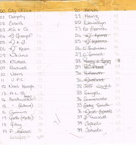 Bendigo Historical Society Inc.
Document - BENDIGO SALEYARDS COLLECTION: PHONE NUMBERS?
... Names are: City Office, Dalgety, Elders, Hill & Co, McGregor, M & J, McKean, Nevins, Nuttall, Rodwell, Vains, V.P.C., Noel Keogh, A.L.B., Borthwicks (Melb), Borthwicks (Portland), Crimmins, Gath (Melb), Gilby, P Harris, Herds, Heinz, Llewellyn, La Franchi, McKenna, McKibbins, O'Sullivans, O'Connell, Penny & Lang, R Plant, Rutlands, Midfield, Jeff Wright, Seigel, Somerville, Eddy Smith, Meat Exports, J Truscott, Talbots, Talbots, Western Dist, Wignalls, Frank Belot, D'ford Ab's, Hardwicks, riverland, G Watson, Ferntree Gully, Gath (Tat), Gath (Wang), Largo, Wagstaff, Ralph, Pertunia Factory, Ambulance, Police, Fire Brigade, Rob Huntington, Fleece Inn, K & J Moss, Newmarket, Dept of Ag and Abbotts Supplies, It has sticky tape along the top and an extra piece of paper is sticky taped to the right hand side....Hill & Co McGregor M & J McKean Nevins Nuttall Rodwell Vains V.P.C. Noel Keogh A.L.B. Borthwicks (Melb) Borthwicks (Portland) Crimmins Gath (Melb) Gilby P Harris Herds Heinz Llewellyn La Franchi McKenna McKibbins O'Sullivans O'Connell Penny & Lang R Plant Rutlands Midfield Jeff Wright Seigel Somerville Eddy Smith Meat Exports J Truscott Talbots Talbots Western Dist Wignalls Frank Belot D'ford Ab's Hardwicks riverland G Watson Ferntree Gully Gath (Tat) Gath (Wang) Largo Wagstaff Ralph Pertunia Factory Ambulance Police Fire Brigade Rob Huntington Fleece Inn K & J Moss Newmarket Dept of Ag Abbotts Supplies Paper with list of names of businesses and individuals with a two figure number, possible quick phone numbers. ...Paper with list of names of businesses and individuals with a two figure number, possible quick phone numbers. Names are: City Office, Dalgety, Elders, Hill & Co, McGregor, M & J, McKean, Nevins, Nuttall, Rodwell, Vains, V.P.C., Noel Keogh, A.L.B., Borthwicks (Melb), Borthwicks (Portland), Crimmins, Gath (Melb), Gilby, P Harris, Herds, Heinz, Llewellyn, La Franchi, McKenna, McKibbins, O'Sullivans, O'Connell, Penny & Lang, R Plant, Rutlands, Midfield, Jeff Wright, Seigel, Somerville, Eddy Smith, Meat Exports, J Truscott, Talbots, Talbots, Western Dist, Wignalls, Frank Belot, D'ford Ab's, Hardwicks, riverland, G Watson, Ferntree Gully, Gath (Tat), Gath (Wang), Largo, Wagstaff, Ralph, Pertunia Factory, Ambulance, Police, Fire Brigade, Rob Huntington, Fleece Inn, K & J Moss, Newmarket, Dept of Ag and Abbotts Supplies, It has sticky tape along the top and an extra piece of paper is sticky taped to the right hand side.bendigo, council, cattle markets, bendigo saleyards collection - phone numbers?, city office, dalgety, elders, hill & co, mcgregor, m & j, mckean, nevins, nuttall, rodwell, vains, v.p.c., noel keogh, a.l.b., borthwicks (melb), borthwicks (portland), crimmins, gath (melb), gilby, p harris, herds, heinz, llewellyn, la franchi, mckenna, mckibbins, o'sullivans, o'connell, penny & lang, r plant, rutlands, midfield, jeff wright, seigel, somerville, eddy smith, meat exports, j truscott, talbots, talbots, western dist, wignalls, frank belot, d'ford ab's, hardwicks, riverland, g watson, ferntree gully, gath (tat), gath (wang), largo, wagstaff, ralph, pertunia factory, ambulance, police, fire brigade, rob huntington, fleece inn, k & j moss, newmarket, dept of ag, abbotts supplies -
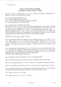 Bendigo Historical Society Inc.
Document - AUCTION SALES - MINING CATALOGUE AUCTION SALES
... Talbot Alluvials Norbury's No. 2 Shaft... Gordon Gold Mine Inglewood... Post Office Hill...Goldfields Limited, Koch's Air Station, Cornish Mine, Carlisle Battery, Victory & Pandora Mine, Garden Gully, Londonderry Mine, Princess Dagmar, Golden Age, Suffolk United, Virginia South Extended, South Red White & Blue, Pitfield Plains Glenfine South Shaft, Adelong Dredge & Leases, Bright Valley Dredge, North Chewton (Chewton), Talbot Alluvials Norbury's No. 2 Shaft, Gordon Gold Mine Inglewood, Post Office Hill Mine Chewton, Carlisle & Whittaker Plant Maldon, Bunninyong, Yandoit Mine, North Chewton, Golden Transverse Bdgo, Yandoit Co., Chapman's Gold Mine Chewton, Ross Creek Extended G. ...Goldfields Limited Koch's Air Station Cornish Mine Carlisle Battery Victory & Pandora Mine Garden Gully Londonderry Mine Princess Dagmar Golden Age Suffolk United Virginia South Extended South Red White & Blue Pitfield Plains Glenfine South Shaft Adelong Dredge & Leases Bright Valley Dredge North Chewton (Chewton) Talbot Alluvials Norbury's No. 2 Shaft Gordon Gold Mine Inglewood Post Office Hill Mine Chewton Carlisle & Whittaker Plant Maldon Bunninyong Yandoit Mine North Chewton Golden Transverse Bdgo Yandoit Co. ...BHS CollectionYellow and white patterned, spring back Spirax Students No. 594 Note Book containing extracts from mining Catalogues loaned by Mr. Dyett (J. H. Curnow's). Mines mentioned include Ramrod Gold Mine, Hercules No. 1, Central Blue, South Virginia Extended, Alfords Battery, South New Moon,The Gold Mine Clunes, Guildford Plateau, Big Blue, Spring Gully Mine at Chewton, Eureka Central at Chewton, Bdgo Amalg. Goldfields Limited, Koch's Air Station, Cornish Mine, Carlisle Battery, Victory & Pandora Mine, Garden Gully, Londonderry Mine, Princess Dagmar, Golden Age, Suffolk United, Virginia South Extended, South Red White & Blue, Pitfield Plains Glenfine South Shaft, Adelong Dredge & Leases, Bright Valley Dredge, North Chewton (Chewton), Talbot Alluvials Norbury's No. 2 Shaft, Gordon Gold Mine Inglewood, Post Office Hill Mine Chewton, Carlisle & Whittaker Plant Maldon, Bunninyong, Yandoit Mine, North Chewton, Golden Transverse Bdgo, Yandoit Co., Chapman's Gold Mine Chewton, Ross Creek Extended G. M. Coy (Ballarat).book, bendigo, mining auction sales, auction sales mining catalogue auction sales, j h curnow, mr dyett, a richardson, ramrod gold mine, hercules no. 1, central blue, south virginia extended, alfords battery, south new moon, the gold mine clunes, guildford plateau, big blue, spring gully mine at chewton, eureka central at chewton, bdgo amalg. goldfields limited, koch's air station, cornish mine, carlisle battery, victory & pandora mine, garden gully, londonderry mine, princess dagmar, golden age, suffolk united, virginia south extended, south red white & blue, pitfield plains glenfine south shaft, adelong dredge & leases, bright valley dredge, north chewton (chewton), talbot alluvials norbury's no. 2 shaft, gordon gold mine inglewood, post office hill mine chewton, carlisle & whittaker plant maldon, bunninyong, yandoit mine, north chewton, golden transverse bdgo, yandoit co., chapman's gold mine chewton, ross creek extended g. m. coy (ballarat). -
 Bendigo Historical Society Inc.
Document - ARTICLES FOR ROYAL HISTORICAL SOCIETY (BENDIGO BRANCH) NEWSLETTER DECEMBER 1972
... Talbot Hotel, Harcourt; Mr Wheatcroft.3. ''Memories of Old East Bendigo'' - original draft with alterations in handwriting; mention of 71 Strickland Rd; Government Powder Magazine; Purdon family; the ''Irish Castle'' (at one time the Charlston Hotel); Mr Sullivan; Mr Burns; Pritchard and Chamberlain (brewery); Solomons Hill; Day's asphfelt (sic) and bone works; Marist Brothers 'Jounerate ' (sic)??...Talbot Hotel, Harcourt; Mr Wheatcroft.3. ''Memories of Old East Bendigo'' - original draft with alterations in handwriting; mention of 71 Strickland Rd; Government Powder Magazine; Purdon family; the ''Irish Castle'' (at one time the Charlston Hotel); Mr Sullivan; Mr Burns; Pritchard and Chamberlain (brewery); Solomons Hill; Day's asphfelt (sic) and bone works; Marist Brothers 'Jounerate ' (sic)?? ...Articles for Royal Historical Society (Bendigo Branch) Newsletter December 1972. 1. ''Bells in and around Bendigo - No 3 - The Hand Bells of St Pauls Church, Bendigo'' - mention of Mr Bill Robertson; Dr J B Pounds; Bendigo Bell Ringers Club; Whitechapel Bell Foundry, London; Odd Fellows Hall; St Pauls Bell Band; Dr A M Bush. 2. ''A sight worth seeing'' - description of the rolling down from the top of Mr Alexander of a large boulder (for entertainment!) in 1860 (extract from the Bendigo Advertiser); mention of Mr Plowright, Talbot Hotel, Harcourt; Mr Wheatcroft.3. ''Memories of Old East Bendigo'' - original draft with alterations in handwriting; mention of 71 Strickland Rd; Government Powder Magazine; Purdon family; the ''Irish Castle'' (at one time the Charlston Hotel); Mr Sullivan; Mr Burns; Pritchard and Chamberlain (brewery); Solomons Hill; Day's asphfelt (sic) and bone works; Marist Brothers 'Jounerate ' (sic)??; Hines Flower Nursery; Mr Hamson MP; Carlile Bros skin and hide store; Kitchen's Soap factory; ''Green Gates'' Hotel; Bendigo Fertiliser Works;bendigo, history, city history. the goldfields. -
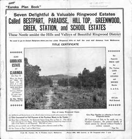 Ringwood and District Historical Society
Pamphlet, Land Sale Brochure Titled Eureka Plan Book - Seven Delightful & Valuable Ringwood Estates - circa 1925
... Plan of Hill Top Estate, Ringwood (later Heathmont area), includes Heathmont Railway Station, Heathmont Road, Balfour Avenue, Lilian Street, Edith Street, Edna Street and Great Ryrie Street. Plan of Goodluck Estate, Clarinda, includes Talbot...Plan of Hill Top Estate, Ringwood (later Heathmont area), includes Heathmont Railway Station, Heathmont Road, Balfour Avenue, Lilian Street, Edith Street, Edna Street and Great Ryrie Street. Plan of Goodluck Estate, Clarinda, includes Talbot ...Twenty page land sale brochure including photographs, subdivision features and local facilities. Additional flyer with conditions of sale and prices for estate blocks.Seven delightful and valuable Ringwood Estates called Bestpart, Paradise, Hill Top, Greenwood, Creek, Station, and School Estates. These nestle amidst the hills and valleys of beautiful Ringwood district. Also Goodluck Estate at Clarinda. Pamphlet marked as being From Mr. Farmer, No. 5 Flinders Court, Melbourne. Phone 988, 989 Central, or 55 Ringwood after 7 p.m. Plan of Ringwood School Estate includes William Street (later Kendall Street), Greenwood Avenue, Alton Street and Locke Street. Plan of Bestpart Estate, Ringwood, includes Bedford Road, Wilana Street, Greenwood Avenue, Caroline Street, Henry Street and Haig Street. Plan of Ringwood Station Estate includes Pitt Street, Bedford Road, Greenwood Avenue, Station Street, William Street (later Kendall Street, James Street, Wantirna Road, Caroline Street, Henry Street, Ellison Street and Haig Street. Plan of Geenwood Estate, Ringwood, includes Prussian Road (later Geenwood Avenue). Plan of Paradise Estate, Ringwood, includes Canterbury Road, Dandenong Road (Wantirna Road), Luck Street and Paradise Road. Plan of Creek Estate, Ringwood, includes Dandenong Creek, Wantirna Road and Gordon Crescent. Plan of Hill Top Estate, Ringwood (later Heathmont area), includes Heathmont Railway Station, Heathmont Road, Balfour Avenue, Lilian Street, Edith Street, Edna Street and Great Ryrie Street. Plan of Goodluck Estate, Clarinda, includes Talbot Avenue, Good Street, Luck Street, and Centre Road in locality plan between Oakleigh and Clayton Railway Stations. -
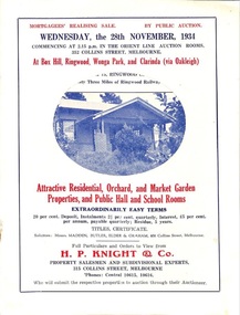 Ringwood and District Historical Society
Flyer, Stillwell & Stephens Pty. Ltd, Brochure - Multiple Properties for Public Auction at Box Hill, Ringwood, Wonga Park and Clarinda - 28th November, 1934
... Box Hill - Whitehorse Road, South-east corner of Linsley Street - Timber building utilised as a Public Hall and Private School. 6. Clarinda vic Oakleigh, Talbot...Box Hill - Whitehorse Road, South-east corner of Linsley Street - Timber building utilised as a Public Hall and Private School. 6. Clarinda vic Oakleigh, Talbot ...Seven-page brochure advertising Mortgagees' Realising Sale by Public Auction on Wednesday, 28th November, 1934 for properties at Box Hill, Ringwood, Wonga Park, and Clarinda (via Oakleigh), including photographs, property descriptions, and terms of sale.Auction Commencing at 2.15 p.m. in the Orient Line Auction Rooms, 352 Collins Street, Melbourne. Solicitors: Messrs. Madden, Butler, Elder & Graham, 406 Collins Street, Melbourne. (Agents) H.P. Knight & Co. Property Salesmen and Subidivisional Experts, 315 Collins Street, Melbourne, 'Phones: Central 10615, 10616. Attractive Residential, Orchard, and Market Garden Properties, and Public Hall and School Rooms. 1. Wonga Park via Ringwood - "Holme Bush" off Warrandyte Road, Part of Lots 14 and 15, Ringwood Orchard Estate, approximatgely three miles (north) of Ringwood Railway Station - 64 Acres. 2. 17 Bishop Street, Box Hill - timber residence. 3. Greenwood Avenue, Ringwood - On East Side, 150 feet 3 inches South of Bedford Road - timber attic residence. 4. Ringwood - Wantirna Road, South-east corner of Canterbury Road - Orchard Property of approx. 11-1/2 Acres. 5. Box Hill - Whitehorse Road, South-east corner of Linsley Street - Timber building utilised as a Public Hall and Private School. 6. Clarinda vic Oakleigh, Talbot Crescent, off Centre Road - Home on 10 acres of land. -
Ringwood and District Historical Society
Letter, Letter To the Talbot's from friend Shirley about the arrangements for Jack Harker's burial with Ruby. He died 2001
... Hill Cemetery but when Jack died a year later he could not be nuried with Ruby as he wished. So Shirley, who wrote the letter, related how the problem was solved by cremating Jack and then placing the ashes with Ruby. The Talbots...Hill Cemetery but when Jack died a year later he could not be nuried with Ruby as he wished. So Shirley, who wrote the letter, related how the problem was solved by cremating Jack and then placing the ashes with Ruby. The Talbots ...Ruby was Jack (Archie'S) wife who died in 2000. She was buried in Box Hill Cemetery but when Jack died a year later he could not be nuried with Ruby as he wished. So Shirley, who wrote the letter, related how the problem was solved by cremating Jack and then placing the ashes with Ruby. The Talbots lived in Queensland.3 pages hand written on heavy pink paper. No date or address which has been cut off.right hand corner page one. -
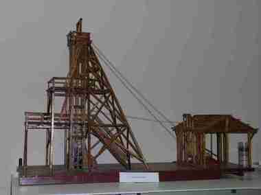 Federation University Historical Collection
Unknown - Model, Poppet Head Model
... Talbot worked in mines in Ballarat, and made the model of the poppet head. The poppet head is a replica of those used at many mines in Ballarat. Back in the 1850s Ballarat was a god rush town and many mining claims were made and poppet heads built this is a replica of those poppet heads which are a part of Ballarat's Heritage and a full size poppet head is erected at Sovereign Hill Theme Park in Ballarat. ...This scale model of a mining plant was made by Donald Douglas Mather of Talbot. The engine shed houses the winches, which raise and lower the cages carrying the workmen. The winches also control the water-Baling tanks, which are lowered into the pump shaft to clean the water. The Pump Shaft is part of the main shaft partitioned off for keeping the water down. The old style plant (or cas commonly known poppet legs), were all of timber construction and, when erected, straddled the main shaft. This scale model allows for steel construction, and is set over the shaft to permit an unobstructed view of the operations. The Bad level is where the workmen enter and leave the shaft. The staging platform on the first level is where the trucks and mullock or other material are wheeled out on rails and then tipped to form the mine dump. The top level is to allow for maintenance of plant. Donald Douglas Mather of Talbot worked in mines in Ballarat, and made the model of the poppet head. The poppet head is a replica of those used at many mines in Ballarat. Back in the 1850s Ballarat was a god rush town and many mining claims were made and poppet heads built this is a replica of those poppet heads which are a part of Ballarat's Heritage and a full size poppet head is erected at Sovereign Hill Theme Park in Ballarat. Mining is a huge part of Ballarat's history.A timber poppet head and engine room model. "This scale model - the modern construction of a mining plant - was made by Mr Donald Douglas Mather* of Bonnie Doon, Talbot, Victoria. The engine shed houses the winches, which raise and lower the cages carrying the workmen. The winches also control the water-baling tanks, which are lowered into the pump shaft to clean the water. The pump shaft is part of the main shaft partitioned off for keeping the water down. The old style plant (or as commonly known poppet legs), were all of timber construction and, when erected, straddled the main shaft. this scale model allows for steel construction, ans is set over the shaft to permit an unobstructed view of the operations. The bad level is where the workmen enter and leave the shaft. The staging platform on the first level is where trucks ad mullock or other material are wheeled out on rails and then tipped to form the mine dump. The top level is to allow for maintenance of plant. * Mr Mater, previously of Ballarat, worked for many years as a miner and plant erector" (Old interpretive panel)mining, mather, mining plant, poppet head, engine house, model, donald douglas mather -
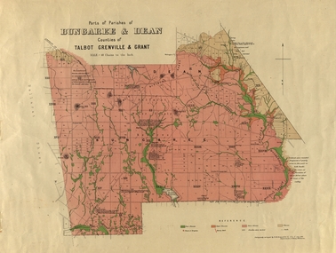 Federation University Historical Collection
Plan, Bungaree and Dean Parish and Geological Plan, 1890, 07/1890
... hill beale's reservoir acquainted. Geological and Parish Map of parts of the Parishes of Bungaree and Dean in the Counties of Talbot, Grenville and Grant. ...Ferdinand M. Krause was a Professor at the Ballarat School of Mines.Geological and Parish Map of parts of the Parishes of Bungaree and Dean in the Counties of Talbot, Grenville and Grant. The scale is 40 chains to one inch. bungaree, deen, krause, f.m. krause, musk creek, clarkes hill, badger hill, beale's reservoir, acquainted. -
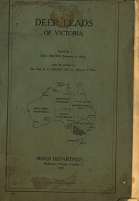 Federation University Historical Collection
Book, Mines Department, Victoria, Deep Leads of Victoria, 1937, 1937
... talbot...woady yalloak...tunnelling...deep sinking...chiltern method of working...ballarat method of working...sampling washdirt. gravels...balmoral...mt william...stawell...moyston...great western...ararat...raglan...wimmera valley...landsborough...cardigan...haddon...beaufort...waterloo...avoca...lamplough...caralulup...ballarat west...ballarat...smythesdale...illabarook...durham lead...morrison's lead...bullengarook...berry-moolort-loddon system...clunes...creswick...spring hill...Contents include Ballarat, berry Consols, Canadian Lead, Castlemaine-Daylesford System, Chiltern, Duke of Cornwall Mine, Dyke's Freehold, Frenchman's Lead, Garibaldi Shaft, Glenfine, Guidlford, Hepburn Estate Co., Hepburn Home Paddock, Italian Gully, Henderson's Lead, Langi Logan, Leigh Consols, Sebastopol Plateau; Talbot, Woady Yalloak, A definition of a deep lead, formation of deep leads, water in deep leads, methods of deep lead mining (Tunnelling, Deep sinking, Chiltern method of working, Ballarat method of working), sampling washdirt and gravels, Balmoral, Mt William, Stawell, Moyston, Great Western, Ararat, Raglan, Wimmera Valley, Landsborough, Cardigan, Haddon, Beaufort, Waterloo, Avoca, Lamplough, Caralulup, Ballarat West, Ballarat, Smythesdale, Glenfine, Illabarook, Durham Lead, Morrison's Lead, Bullengarook, Berry-Moolort-Loddon System, Clunes, Creswick, Spring Hill, Bullarook, Castlemaine - Daylesford, Majorca, Carisbrook, Timor, Burnt Creek Tributary, Tarnagulla, Marong, Rheola, Inglewood, Huntly, Coliban, Campaspe, Goulburn Lead System, Ovens Valley System, Mitta Mitts, Kiewa Valley, Tarago, Tanjil, Moondarra, Bogong, Dargo High Plains, glossary...Barker Library (top floor) Mount Helen goldfields mining deep leads mines department squire leigh consols chiltern duke of cornwall mine dyke's freehold frenchman's lead garibaldi shaft glenfine guidlford hepburn estate co. hepburn home paddock italian gully henderson's lead langi logan sebastopol plateau talbot woady yalloak tunnelling deep sinking chiltern method of working ballarat method of working sampling washdirt. gravels balmoral mt william stawell moyston great western ararat raglan wimmera valley landsborough cardigan haddon beaufort waterloo avoca lamplough caralulup ballarat west ballarat smythesdale illabarook durham lead morrison's lead bullengarook berry-moolort-loddon system clunes creswick spring hill bullarook castlemaine - daylesford majorca carisbrook timor burnt creek tributary tarnagulla marong rheola inglewood huntly coliban campaspe goulburn lead system ovens valley system mitta mitta kiewa valley tarago tanjil moondarra bogong dargo high plains Charcoal green soft covered book of 64 pages. ...Charcoal green soft covered book of 64 pages. Contents include Ballarat, berry Consols, Canadian Lead, Castlemaine-Daylesford System, Chiltern, Duke of Cornwall Mine, Dyke's Freehold, Frenchman's Lead, Garibaldi Shaft, Glenfine, Guidlford, Hepburn Estate Co., Hepburn Home Paddock, Italian Gully, Henderson's Lead, Langi Logan, Leigh Consols, Sebastopol Plateau; Talbot, Woady Yalloak, A definition of a deep lead, formation of deep leads, water in deep leads, methods of deep lead mining (Tunnelling, Deep sinking, Chiltern method of working, Ballarat method of working), sampling washdirt and gravels, Balmoral, Mt William, Stawell, Moyston, Great Western, Ararat, Raglan, Wimmera Valley, Landsborough, Cardigan, Haddon, Beaufort, Waterloo, Avoca, Lamplough, Caralulup, Ballarat West, Ballarat, Smythesdale, Glenfine, Illabarook, Durham Lead, Morrison's Lead, Bullengarook, Berry-Moolort-Loddon System, Clunes, Creswick, Spring Hill, Bullarook, Castlemaine - Daylesford, Majorca, Carisbrook, Timor, Burnt Creek Tributary, Tarnagulla, Marong, Rheola, Inglewood, Huntly, Coliban, Campaspe, Goulburn Lead System, Ovens Valley System, Mitta Mitts, Kiewa Valley, Tarago, Tanjil, Moondarra, Bogong, Dargo High Plains, glossarymining, deep leads, mines department, squire, leigh consols, chiltern, duke of cornwall mine, dyke's freehold, frenchman's lead, garibaldi shaft, glenfine, guidlford, hepburn estate co., hepburn home paddock, italian gully, henderson's lead, langi logan, sebastopol plateau, talbot, woady yalloak, tunnelling, deep sinking, chiltern method of working, ballarat method of working, sampling washdirt. gravels, balmoral, mt william, stawell, moyston, great western, ararat, raglan, wimmera valley, landsborough, cardigan, haddon, beaufort, waterloo, avoca, lamplough, caralulup, ballarat west, ballarat, smythesdale, illabarook, durham lead, morrison's lead, bullengarook, berry-moolort-loddon system, clunes, creswick, spring hill, bullarook, castlemaine - daylesford, majorca, carisbrook, timor, burnt creek tributary, tarnagulla, marong, rheola, inglewood, huntly, coliban, campaspe, goulburn lead system, ovens valley system, mitta mitta, kiewa valley, tarago, tanjil, moondarra, bogong, dargo high plains -
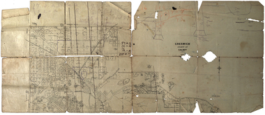 Federation University Historical Collection
Plan, Creswick, County of Talbot
... Gift of the Squire Family, 2014 creswick creswick creek spring hill sarah paterson lehman mullins spittle squire richard squire Plan showing allotments in Creswick, County of Talbot. ...This plan is associated with former Ballarat School of Mines Student Richard Squire (1875-1876). Gift of the Squire Family, 2014 Plan showing allotments in Creswick, County of Talbot. The plan is in a number of pieces with some sections missing.creswick, creswick creek, spring hill, sarah paterson, lehman, mullins, spittle, squire, richard squire -
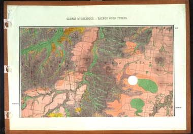 Federation University Historical Collection
Map, Clunes, Mt Greenock, and Talbot Gold Fields, 1883, 1883
... A geological plan of the Clunes, Mt Greenock, and Talbot Gold Fields in two parts. .1) This section of the map includes Talbot, Talbot water supply race, Mt Glasgow, Little Green Hill, Middle Hill, Mt Cameron, Ballarat Hill, Bakery Hill, Goodwoman Hill, Scandanavian Lead, Eglinton Swamp, McCallum's Creek, Tullaroop Creek, Dunach, Maryborough Railway, Middle Creek and includes many mines such as Rip Van Winkel, Union Extended, South Greenock, Nicholl's Freehold. .2) This section of the map includes McCallums, Clunes, Green Hill, Mt Beckworth, Mt Gap, Maryborough Reservoir, and includes mines such as Lothair, Bute, Clyde, Clunes Consols, London and Australian, Oriental,...Barker Library (top floor) Mount Helen goldfields clunes talbot water supply railway geology A geological plan of the Clunes, Mt Greenock, and Talbot Gold Fields in two parts. .1) This section of the map includes Talbot, Talbot water supply race, Mt Glasgow, Little Green Hill, Middle Hill, Mt Cameron, Ballarat Hill, Bakery Hill, Goodwoman Hill, Scandanavian Lead, Eglinton Swamp, McCallum's Creek, Tullaroop Creek, Dunach, Maryborough Railway, Middle Creek and includes many mines such as Rip Van Winkel, Union Extended, South Greenock, Nicholl's Freehold. .2) This section of the map includes McCallums, Clunes, Green Hill, Mt Beckworth, Mt Gap, Maryborough Reservoir, and includes mines such as Lothair, Bute, Clyde, Clunes Consols, London and Australian, Oriental, Clunes, Mt Greenock, and Talbot Gold Fields, 1883 Map Map J. ...A geological plan of the Clunes, Mt Greenock, and Talbot Gold Fields in two parts. .1) This section of the map includes Talbot, Talbot water supply race, Mt Glasgow, Little Green Hill, Middle Hill, Mt Cameron, Ballarat Hill, Bakery Hill, Goodwoman Hill, Scandanavian Lead, Eglinton Swamp, McCallum's Creek, Tullaroop Creek, Dunach, Maryborough Railway, Middle Creek and includes many mines such as Rip Van Winkel, Union Extended, South Greenock, Nicholl's Freehold. .2) This section of the map includes McCallums, Clunes, Green Hill, Mt Beckworth, Mt Gap, Maryborough Reservoir, and includes mines such as Lothair, Bute, Clyde, Clunes Consols, London and Australian, Oriental,clunes, talbot, water supply, railway, geology -
 Federation University Historical Collection
Documents - Reports, Unidentified Large Cat Sightings in Maryborough
... Hill...panther...john dix...ray elliott...dennis wiley...police sightings...graham hunt...Brian Douglas...Stuart Mill...graeme grant...A. venes...avoca...julie hobbs...greg gallagher...taltarni...moonambel...fred beach...majorca...Michael rayner...Chateau Remy...John Robb...Wayne Irvine...Brian anderson...Peter Davies...talbot...Australian Animal Folklore Collection cat ferral cat puma mountain lion Maryborough Maryborough Victoria DS Saunders bryan walters bernie Mall peter chapple. graham george Australian Cougar felid pamela Parker alan Foskett Daisy Hill panther john dix ray elliott dennis wiley police sightings graham hunt Brian Douglas Stuart Mill graeme grant A. venes avoca julie hobbs greg gallagher taltarni moonambel fred beach majorca Michael rayner Chateau Remy John Robb Wayne Irvine Brian anderson Peter Davies talbot Joyce Davies Tom Davies Len farthing Barry rinaldi Edward stone brian Stone Judith tranter Alan Poole Shane Long Jim Smith Lloyd Forge Carisbrook Murray Henderson Doug Grose John Higgins footprint Cast Australian dasyurids felis concolor lioness lion Shane Long Wareek koo-jar hill american troops betley cat daisy hill cat phelan road cat amherst cat john higgin angus Reynolds betley Tiger tim clark walters cougar catcher identification chart David Towler bob carr rare fauna research society lancefield cat bernie mace robert pattison Bryan de lacy romsey murray henderson brian collinson neil grummett grummett kenneth Lamont Lamont foskett hobbs rinaldi poole forge henderson grant elliott anderson stone irvine douglas stewart long mythical myth folklore australian mythical animals collection david waldron Land Protection d.s. saunders judith henke ravenswood wedderburn feral cat laanecoorie shellbourne barru rinaldi lan poole dorothy smith amherst cemetery graham grant maryborough advertiser Central victorian cat st arnaud Kyneton Shane one Wareek lack of fossil evidence koo-jat hill cougar hill plaster casts lummis goldsborough Ian Lummis Hamilton Swan hill wodonga A number of A4 printouts relating to large cat sightings in the Maryborough (Vic) area, many reported by the Marlborough Advertiser. ...The folder or correspondence is the result of a Freedom of Informaition request made to the Department of Primary Industries in 2011. The folder was collected for research being conducted by David Waldron. John Higgins, managing editor of the Maryborough Advertiser was interested in sightings of what some suggested to be a puma or mountain lion in Central Victoria. A number of A4 printouts relating to large cat sightings in the Maryborough (Vic) area, many reported by the Marlborough Advertiser. The large cat referred to is often referred to as a Puma or Mountain Lion. (.7) Profile of Central Victorian Cat Australian Animal Folklore Collectionaustralian animal folklore collection, cat, ferral cat, puma, mountain lion, maryborough, maryborough victoria, ds saunders, bryan walters, bernie mall, peter chapple. graham george, australian cougar, felid, pamela parker, alan foskett, daisy hill, panther, john dix, ray elliott, dennis wiley, police sightings, graham hunt, brian douglas, stuart mill, graeme grant, a. venes, avoca, julie hobbs, greg gallagher, taltarni, moonambel, fred beach, majorca, michael rayner, chateau remy, john robb, wayne irvine, brian anderson, peter davies, talbot, joyce davies, tom davies, len farthing, barry rinaldi, edward stone, brian stone, judith tranter, alan poole, shane long, jim smith, lloyd forge, carisbrook, murray henderson, doug grose, john higgins, footprint cast, australian dasyurids, felis concolor, lioness, lion, shane long, wareek, koo-jar hill, american troops, betley cat, daisy hill cat, phelan road cat, amherst cat, john higgin, angus reynolds, betley tiger, tim clark, walters cougar catcher, identification chart, david towler, bob carr, rare fauna research society, lancefield cat, bernie mace, robert pattison, bryan de lacy, romsey, murray henderson, brian collinson, neil grummett, grummett, kenneth lamont, lamont, foskett, hobbs, rinaldi, poole, forge, henderson, grant, elliott, anderson, stone, irvine, douglas, stewart, long, mythical, myth, folklore, australian mythical animals collection, david waldron, land protection, d.s. saunders, judith henke, ravenswood, wedderburn, feral cat, laanecoorie, shellbourne, barru rinaldi, lan poole, dorothy smith, amherst cemetery, graham grant, maryborough advertiser, central victorian cat, st arnaud, kyneton, shane one wareek, lack of fossil evidence, koo-jat hill, cougar hill, plaster casts, lummis, goldsborough, ian lummis, hamilton, swan hill, wodonga -
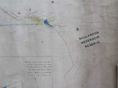 Federation University Historical Collection
Plan, Creswick Water Supply from Bullarook to Creswick, 02/10/1869
... hill sluicing co frank rivers w.r. taylor j. and m. mccormack j. mcdonald richard brown c. naples Large horizontal paper plan glued in three sections to a linen backing. Coloured plan shows pipe and rack track from the Bullarook Reservoir to Albert Street, Creswick. Attached with ribbon top left are twelve pages giving bearing and lengths / descriptions of pipe and rack track. Five information boxes drawn along the bottom of plan gives extra information where pipe passes through private properties. Main heading 'Plan of Creswick Water Supply / scale eight chains to an inch / County of Talbot ...Probably gazetted on 12 April 1872 (pg 737)Large horizontal paper plan glued in three sections to a linen backing. Coloured plan shows pipe and rack track from the Bullarook Reservoir to Albert Street, Creswick. Attached with ribbon top left are twelve pages giving bearing and lengths / descriptions of pipe and rack track. Five information boxes drawn along the bottom of plan gives extra information where pipe passes through private properties. Main heading 'Plan of Creswick Water Supply / scale eight chains to an inch / County of Talbot / Parish of Creswick'. Calculations and hand written notes in ink and pencil also on plan. Verso 'Dean Reservoir'. Signed and dated.creswick, water supply, bullurook reservoir, dean, bush inn, hesken, rivers, warner, taylor, gillard, mccormack, mcdonald, brown, naples, humbug hill sluicing co, frank rivers, w.r. taylor, j. and m. mccormack, j. mcdonald, richard brown, c. naples -
Federation University Historical Collection
Book, Historic Sites Survey: North Central Study Area, 1979, 1979
... hill...fosterville...coliban water works...green gully...newstead...muckleford forest...costerfield...graytown...bailieston...waranga irrigaiton system...eucalyptus distillery...mia mia bridge...korokubeal township researce...concegella slate quarry...chewton...fryerstown...kingower...timor...talbot...Barker Library (top floor) Mount Helen goldfields The North Central Study Area included the Shires of Avoca, Bet Bet, east Loddon, Goulburn, Untly, Kara Kara, Korong, Maldon, Marong, Metcalfe, McIvor, Newstead, Strathfieldsaye, Stawell, Talbot, Clunes, Tullaroop and Waranga. castlemaine mount alexander goldfield maldon percydale warrenmang moliagul tarnagulla stuart mill the whipstick whroo rushworth graytown ironbark forest st arnoaud new bendigo landsborough inglewood kurting wedderburn wehla kooroora langham flat mcintyre rheola diamond hill fosterville coliban water works green gully newstead muckleford forest costerfield graytown bailieston waranga irrigaiton system eucalyptus distillery mia mia bridge korokubeal township researce concegella slate quarry chewton fryerstown kingower timor talbot majorca carisbroook clunes st arnaud taradale icomos dunolly limestone castlemaine slate quarry harcourt granite taradale railway viaduct loddon united waterworks trust gouldburn weir carisbrook lock-up history of tree planting in streets history of public reserves r.u. nicholls nurseryman thomas lang francis moss ballarat botanical gardens ballarat school of mines botanical gardens lake wendouree victoria park, ballarat muont holled smith ballaarat old cemetery planting eastern oval ballarat east botanical gardens ballarat east town hall gardens eureka stockade reserve ballarat observatory plantings yarrowee creek plantings yarrowee bluestone channels ballarat woollen mill band and albion mullock heap black hill plantings yarrowee creek channels canadian creek channel specimen vale channel poverty point reserve union jack reserve buninyong imperial mine, buninyong victoria street plantings bridge mall sturt street gardens ballarat avenue of honour plantings white flat oval plantings camp street elms burnt creek 153 page book with white plastic binding. ...The North Central Study Area included the Shires of Avoca, Bet Bet, east Loddon, Goulburn, Untly, Kara Kara, Korong, Maldon, Marong, Metcalfe, McIvor, Newstead, Strathfieldsaye, Stawell, Talbot, Clunes, Tullaroop and Waranga. 153 page book with white plastic binding. It is an historic sites survey for the North Central Study Area commissioned by the Land Conservation Council, the Ministry for COnservation and the Australian Heritage Commission. castlemaine, mount alexander goldfield, maldon, percydale, warrenmang, moliagul, tarnagulla, stuart mill, the whipstick, whroo, rushworth, graytown ironbark forest, st arnoaud, new bendigo, landsborough, inglewood, kurting, wedderburn, wehla, kooroora, langham flat, mcintyre, rheola, diamond hill, fosterville, coliban water works, green gully, newstead, muckleford forest, costerfield, graytown, bailieston, waranga irrigaiton system, eucalyptus distillery, mia mia bridge, korokubeal township researce, concegella slate quarry, chewton, fryerstown, kingower, timor, talbot, majorca, carisbroook, clunes, st arnaud, taradale, icomos, dunolly, limestone, castlemaine slate quarry, harcourt granite, taradale railway viaduct, loddon united waterworks trust, gouldburn weir, carisbrook lock-up, history of tree planting in streets, history of public reserves, r.u. nicholls nurseryman, thomas lang, francis moss, ballarat botanical gardens, ballarat school of mines botanical gardens, lake wendouree, victoria park, ballarat, muont holled smith, ballaarat old cemetery planting, eastern oval, ballarat east botanical gardens, ballarat east town hall gardens, eureka stockade reserve, ballarat observatory plantings, yarrowee creek plantings, yarrowee bluestone channels, ballarat woollen mill, band and albion mullock heap, black hill plantings, yarrowee creek channels, canadian creek channel, specimen vale channel, poverty point reserve, union jack reserve buninyong, imperial mine, buninyong, victoria street plantings, bridge mall, sturt street gardens, ballarat avenue of honour plantings, white flat oval plantings, camp street, elms, burnt creek