Showing 1555 items matching "the crown of the road"
-
 Federation University Historical Collection
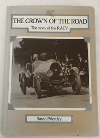
Book, Susan Priestley, The Crown of the Road - The Story of the RACV, 1983
... The Crown of the Road - The Story of the RACV......the crown of the road...Barker Library (top floor) Mount Helen goldfields Henry Sutton was one of the Founding members of the RACV Henry Sutton RACV Royal Automobile Club of Victoria the crown of the road susan priestley sue bates This book tells the story of the Royal Automobile Club of Victoria (RACV) from 1903 to 1980 Image of motor car on front cover with title and author The Crown of the Road - The Story of the RACV Book Australia Victoria South Melbourne Susan Priestley Sue Bates ...This book tells the story of the Royal Automobile Club of Victoria (RACV) from 1903 to 1980Image of motor car on front cover with title and authornon-fictionThis book tells the story of the Royal Automobile Club of Victoria (RACV) from 1903 to 1980henry sutton, racv, royal automobile club of victoria, the crown of the road, susan priestley, sue bates -
 Emerald Museum & Nobelius Heritage Park
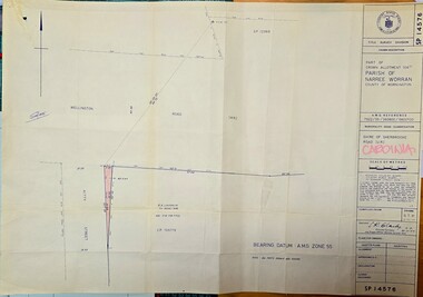
Map - Municipality Road Classification - Wellington Rd. (part), Crown Description - part of Crown Allotment 106 G1, Parish of Narree Worran, c1977
... Image of Title Survey, Part of Crown Allotment 106G1, Road Classification Shire of Sherbrooke Rd (Wellington Rd.)...SP14576/Title Survey Division/Crown Description/Part of Crown Allotment 106 G1, Parish of Narree Worran, County of Mornington/AMG Reference 7922/55/360800/5800100/Municipality Road Classification/Shire of Sherbrooke Road/Kenneth Douglas Adams, Country Roads Board, 60 Denmark Street, Kew, Surveyor, dated 15th November, 1977/Approved S.R. ...CLARKE, Principal Surveyor and Proper Officer 21.11.77 Image of Title Survey, Part of Crown Allotment 106G1, Road Classification Shire of Sherbrooke Rd (Wellington Rd.) ...Image of Title Survey, Part of Crown Allotment 106G1, Road Classification Shire of Sherbrooke Rd (Wellington Rd.)SP14576/Title Survey Division/Crown Description/Part of Crown Allotment 106 G1, Parish of Narree Worran, County of Mornington/AMG Reference 7922/55/360800/5800100/Municipality Road Classification/Shire of Sherbrooke Road/Kenneth Douglas Adams, Country Roads Board, 60 Denmark Street, Kew, Surveyor, dated 15th November, 1977/Approved S.R. CLARKE, Principal Surveyor and Proper Officer 21.11.77 -
 Bendigo Historical Society Inc.
Slide - Mouat Crawford Collection: Farming Life in the Wimmera, c1963
... Flags and banners adorn the street and pennants on the roofs, there is also a large crown above the road. Markings Decorations Bourke & Swanston Sts. ...History House 11 Mackenzie Street Bendigo goldfields mouat crawford collection wimmera melbourne bourke and swanson streets royal visit foys Kodak Flags and banners adorn the street and pennants on the roofs, there is also a large crown above the road. Markings Decorations Bourke & Swanston Sts. ...Flags and banners adorn the street and pennants on the roofs, there is also a large crown above the road. Markings Decorations Bourke & Swanston Sts. Melb. for Moomba and Royal Visit 1963. Used as a teaching aid.Kodakmouat crawford collection, wimmera, melbourne bourke and swanson streets, royal visit, foys -
 Federation University Historical Collection
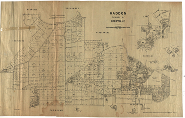
Plan, Haddon, County of Grenville, 1932, 13/04/1932
... The Haddon Parish Plan shows crown parcels government roads, Crown Reserves, Railway. ...haddon grenville cardigan water supply reserve nentingbook pre-emptive right a. mclachlan lake burrumbeet e.a. wynne p. russell b. hepburn benjamin hepburn nentingbool t.c. wilson j. amoy william collard smith james roach j. mitchell The Haddon Parish Plan shows crown parcels government roads, Crown Reserves, Railway. ...The Haddon Parish Plan shows crown parcels government roads, Crown Reserves, Railway. Scale 40 chains to 1" (1:31, 680) WGS 84 Centroid Lat: 37 degrees 34' 00" S Long: 148 degrees 40' 20" E N.S. 9.3km E.W.: 16.1kmhaddon, grenville, cardigan, water supply reserve, nentingbook pre-emptive right, a. mclachlan, lake burrumbeet, e.a. wynne, p. russell, b. hepburn, benjamin hepburn, nentingbool, t.c. wilson, j. amoy, william collard smith, james roach, j. mitchell -
 Greensborough Historical Society
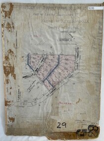
Poster - Planning Document, City of Heidelberg, Subdivision Plan # G 29 Part 1, Crown allotment 17, Greensborough, 1922
... Plan of Subdivisions in City of Heidelberg: Parish of Keelbundoora: Crown allotment 17 - Warwick Road, Clydbank Street, Alexandra Street, 1922....Greensborough Historical Society 34A Glenauburn Road Lower Plenty Lower Plenty melbourne Plan of Subdivisions in City of Heidelberg: Parish of Keelbundoora: Crown allotment 17 - Warwick Road, Clydbank Street, Alexandra Street, 1922. ...Plan of Subdivisions in City of Heidelberg: Parish of Keelbundoora: Crown allotment 17 - Warwick Road, Clydbank Street, Alexandra Street, 1922.An example of hard copy subdivision plans from the Greensborough area. Mainly from the Shire of Diamond Valley era (1964-1994).Plan (single sided) mounted on heavy card. Stamped and handwritten Council permissions, dates and other details.subdivision plans, city of heidelberg -
 Coal Creek Community Park & Museum
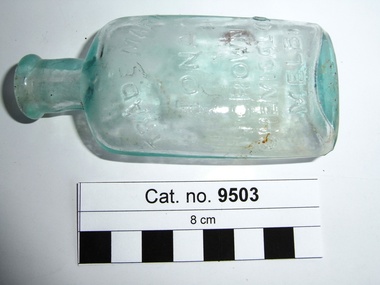
Bottle, glass, c.1908 - c.1938
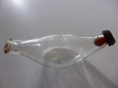
... Tuesday 6 January 1925, page 4, 'Iona Cordial Extract, made by Crown Chemical Co. City Road, South Melbourne'. source Trove....Road Korumburra gippsland Border Watch (Mt. Gambier South Australia) newspaper, Advertisement. Tuesday 6 January 1925, page 4, 'Iona Cordial Extract, made by Crown Chemical Co. ...Border Watch (Mt. Gambier South Australia) newspaper, Advertisement. Tuesday 6 January 1925, page 4, 'Iona Cordial Extract, made by Crown Chemical Co. City Road, South Melbourne'. source Trove.Pale aqua tinted clear glass bottle, ellipse shaped in cross section, embossed text on one side and monogram on base. Slightly asymmetrical, glass surface has some oxidisation (may have been buried or burnt).'TRADE MARK IONA CROWN CHEMICAL CO MELB' on side. AGM monogram on basecordial -
 Hume City Civic Collection
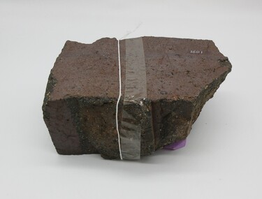
Brick
... The brickworks operated approximately between the years 1859 - 1883 on crown land near Watson's Road, Sunbury. This brick may have come from a ruin near the Organ Pipes....The brickworks operated approximately between the years 1859 - 1883 on crown land near Watson's Road, Sunbury. This brick may have come from a ruin near the Organ Pipes. 1860s 1880s sunbury brick shire of bulla dunn trevor margaret allison robinson george evans collection on top - "ALLISONS' Approximately half a brick brown/red colour smooth at one end uneven sides. ...This half broken brick comes from the brickworks owned by Robinson Allison. The brickworks operated approximately between the years 1859 - 1883 on crown land near Watson's Road, Sunbury. This brick may have come from a ruin near the Organ Pipes.Approximately half a brick brown/red colour smooth at one end uneven sides.on top - "ALLISONS'1860s, 1880s, sunbury, brick, shire of bulla, dunn, trevor, margaret, allison, robinson, george evans collection -
 Emerald Museum & Nobelius Heritage Park
Map - Municipality Road Classification - Wellington Rd. (part) - Near Kitty Street, Crown Survey map - Crown allotments 106F2 & 106 G1 - Wellington Rd. near Kitty Street, c1972
... Image of Title survey - Part of Crown Allotments 106F2 and 106G1 - Wellington Road, Shire of Sherbrooke ...SP12969/Title Survey Division/Crown Description/Part of Crown Alloments 106F2, 106F3 and 106G1, Parish of Narree Worran, County of Mornington/Municipality Road Classification/Shire of Sherbrooke, Wellington Road/(signed) Rossley Paul Gardner of Kirkpatrick & Webber, 280 Maroondah Highway, Ringwood, 29th March 1972/(Signed) S.R. ...CLARKE, Principal Title Survey Officer & Proper Officer 21.6.72 Image of Title survey - Part of Crown Allotments 106F2 and 106G1 - Wellington Road, Shire of Sherbrooke Crown Survey map - Crown allotments 106F2 & 106 G1 - Wellington Rd. near Kitty Street Map Municipality Road Classification - Wellington Rd. ...Image of Title survey - Part of Crown Allotments 106F2 and 106G1 - Wellington Road, Shire of Sherbrooke SP12969/Title Survey Division/Crown Description/Part of Crown Alloments 106F2, 106F3 and 106G1, Parish of Narree Worran, County of Mornington/Municipality Road Classification/Shire of Sherbrooke, Wellington Road/(signed) Rossley Paul Gardner of Kirkpatrick & Webber, 280 Maroondah Highway, Ringwood, 29th March 1972/(Signed) S.R. CLARKE, Principal Title Survey Officer & Proper Officer 21.6.72 -
 Sunbury Family History and Heritage Society Inc.
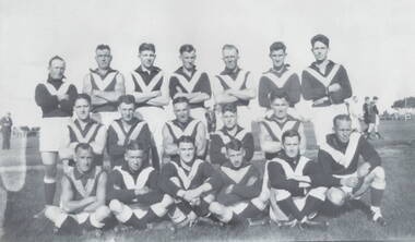
Photograph, Sunbury Football team, C 1930s - 1940s
... For many years that site was known as Sunbury's sports ground until 1949, when crown land facing Riddell Road was developed as a recreation and sport's ground and became known as Clarke Oval....For many years that site was known as Sunbury's sports ground until 1949, when crown land facing Riddell Road was developed as a recreation and sport's ground and became known as Clarke Oval. ...Th members of the Sunbury Football team were photographed on the former sports ground that was on railway land bounded by Evans and Macedon Streets, now a shopping complex. For many years that site was known as Sunbury's sports ground until 1949, when crown land facing Riddell Road was developed as a recreation and sport's ground and became known as Clarke Oval.Sport has played a prominent role in Sunbury and district's social life since the mid nineteenth century.A non-digital of a copied and enlarged black and white photograph of a team of football players standing and sitting in three rows in a sports ground. sunbury football club, "the swifts', sports clubs, football, australian rules football -
 Sunshine and District Historical Society Incorporated
Administrative record - City of Sunshine - Commissioner Mr Alexander Alex George Gillon Collection 1976 - 1982 - Notice of ordinary meeting of the council of the City of Sunshine to be held on 23rd February 1977, City of Sunshine, 16th February 1977
... Hampton Avenue private street scheme Public open space Graham Street South Crown Lands Kororoit Creek Anderson Road Sunshine Land Use Permit Consulting Rooms Ainsworth Avenue Council Officers Reports...City of Sunshine Alexander "Alex" George Gillon Anderson Road Sunshine Graham Street South Hampton Avenue Hampton Avenue private street scheme Public open space Graham Street South Crown Lands Kororoit Creek Anderson Road Sunshine Land Use Permit Consulting Rooms Ainsworth Avenue Council Officers Reports Foolscap sized document. ...Hampton Avenue private street scheme Public open space Graham Street South Crown Lands Kororoit Creek Anderson Road Sunshine Land Use Permit Consulting Rooms Ainsworth Avenue Council Officers Reports city of sunshine, alexander "alex" george gillon, anderson road, sunshine, graham street south, hampton avenue -
Bendigo Historical Society Inc.
Map - CAMPBELL COLLECTION: BENDIGO AND DISTRICT MAPS
... Bendigo Whipstick Forest Park, 1:75,000, reserved forest and crown land, highway main road access forest tracks. New Moon Mine, Elliot Dam, Nuggety Dam, Rogers Tree, Old Tom Mine, Blow Holes, Skylark Dam, Monument Rock, Hartland Eucalyptus Still and Dam, Hartland Eucalyptus Farm, Millwood Dam, Sandner Eucalyptus Still Site, Various unmarked dams. ...Bendigo Whipstick Forest Park, 1:75,000, reserved forest and crown land, highway main road access forest tracks. New Moon Mine, Elliot Dam, Nuggety Dam, Rogers Tree, Old Tom Mine, Blow Holes, Skylark Dam, Monument Rock, Hartland Eucalyptus Still and Dam, Hartland Eucalyptus Farm, Millwood Dam, Sandner Eucalyptus Still Site, Various unmarked dams. ...Map. Bendigo Whipstick Forest Park, 1:75,000, reserved forest and crown land, highway main road access forest tracks. New Moon Mine, Elliot Dam, Nuggety Dam, Rogers Tree, Old Tom Mine, Blow Holes, Skylark Dam, Monument Rock, Hartland Eucalyptus Still and Dam, Hartland Eucalyptus Farm, Millwood Dam, Sandner Eucalyptus Still Site, Various unmarked dams. (number 391 in map cupboard 1)map, bendigo, country lands -
 Bendigo Historical Society Inc.
Photograph - BOTANICAL GARDENS
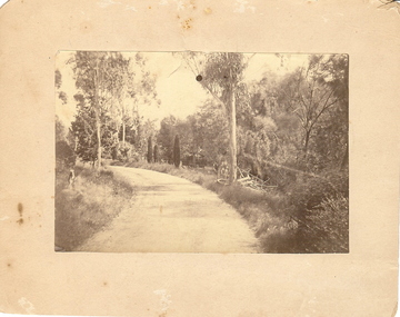
... White Hills Cemetery Reserve. Crowned road grade. Heavy intermediate fence posts....White Hills Cemetery Reserve. Crowned road grade. Heavy intermediate fence posts. ...sepia photograph on cream board. Driveway/pathway, gravelled, eucalypt and conifer trees, uncut grass, wire fence middle distance. Pathway curving to left from front of photo. Written in blue pen on rear of photo : Botanical Gardens or early path in Fortuna. English trees planted, e.g. cypress. Holdsworth Road, adj. White Hills Cemetery Reserve. Crowned road grade. Heavy intermediate fence posts.unknownplace, land, botanical gardens, fortuna ? -
 Warrnambool and District Historical Society Inc.
Document - Ledger: Warrnambool Shire Letter book 1861-1865, Circa 1860
... The index contains the following names :W G Allan, Bostock, Biggs, Bench of Magistrates Caramut, Niel Black, Commissioner of the Crown Lands Warrnambool, Commissioner of Roads and Bridges, Cross, Carr, Duffy, Davies, Duffus, Fitzmaurice, Horace Flower ...roads board a davies 1861-1865 : On the spine is a paper label, “January1861-April 1865.Label inside front cover “Sands &Kenny. Account Book Manufacturers, Stationers &Printers, Collins St Melbourne. The index contains the following names :W G Allan, Bostock, Biggs, Bench of Magistrates Caramut, Niel Black, Commissioner of the Crown Lands Warrnambool, Commissioner of Roads and Bridges, Cross, Carr, Duffy, Davies, Duffus, Fitzmaurice, Horace Flower Fawn cloth on card cover with tan corner and spine binding. ...Contains correspondence pertaining to matters of infrastructure in the period of the 1860’s. The period contained within this ledger is very early in the establishment of the district. It shows the co-operation and initiative between councils, government departments and individuals in matters relating drainage, bridges , roads all vital to the development of the region.Fawn cloth on card cover with tan corner and spine binding. Contains alphabetical index at the front. Letters are written on very fine paper.: On the spine is a paper label, “January1861-April 1865.Label inside front cover “Sands &Kenny. Account Book Manufacturers, Stationers &Printers, Collins St Melbourne. The index contains the following names :W G Allan, Bostock, Biggs, Bench of Magistrates Caramut, Niel Black, Commissioner of the Crown Lands Warrnambool, Commissioner of Roads and Bridges, Cross, Carr, Duffy, Davies, Duffus, Fitzmaurice, Horace Flower warrnambool, warrnambool shire, tenders, district roads board, a davies, 1861-1865 -
 Bendigo Historical Society Inc.
Document - BILL ASHMAN COLLECTION: CORRESPONDENCE
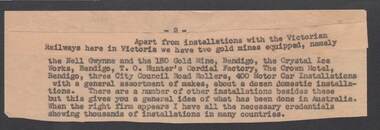
... Hunter's Cordial Factory, The Crown Hotel,Bendigo City Council Road Rollers, car installations and domestic installations. ...Hunter's Cordial Factory, The Crown Hotel,Bendigo City Council Road Rollers, car installations and domestic installations. ...Cut off portion page 2. Top part glued on. List of installations, including the Victorian Railways, the Nell Gwynne and the 180 Gold Mine, Bendigo. The Crystal Ice Works, Bendigo, T. O. Hunter's Cordial Factory, The Crown Hotel,Bendigo City Council Road Rollers, car installations and domestic installations. Also mentioned when the right firm appears all the necessary credentials showing thousands of installations in many countries are ready.sciences, instruments - general, scalebuoy, bill ashman collection - correspondence, victorian railways, nell gwynne, 180 gold mine bendigo, crystal ice works, t o hunter's cordial factory, the crown hotel, city council -
Federation University Historical Collection
Article - Cycling Jersey, FedUni AusCycling National Championships Jersey, 2022
... In road racing, winning riders of national championships are crowned as: * Men's Elite Road Race Champion * Men's Elite Time Trial Champion * Women's Road Race Champion * Women's Time Trial Champion * Men's Under-23 Road Race Champion * Men's Under-23 Time Trial Champion The Australian Champion Jersey is awarded to the winner, or the highest placed Australian in all events at the Federation University AusCycling National Championships. ...In road racing, winning riders of national championships are crowned as: * Men's Elite Road Race Champion * Men's Elite Time Trial Champion * Women's Road Race Champion * Women's Time Trial Champion * Men's Under-23 Road Race Champion * Men's Under-23 Time Trial Champion The Australian Champion Jersey is awarded to the winner, or the highest placed Australian in all events at the Federation University AusCycling National Championships. ...National road cycling championships are held annually by host nations in each cycle racing discipline. The annual events can take place at any time of the year. Australia usually holds their annual event during summer. In road racing, winning riders of national championships are crowned as: * Men's Elite Road Race Champion * Men's Elite Time Trial Champion * Women's Road Race Champion * Women's Time Trial Champion * Men's Under-23 Road Race Champion * Men's Under-23 Time Trial Champion The Australian Champion Jersey is awarded to the winner, or the highest placed Australian in all events at the Federation University AusCycling National Championships. Winners may wear their Australian Champion Jersey in all events in the discipline speciality and category in which they won their title and no other event up until the day before the championship event of the following year. Category Winners in 2022 were Lucas Plapp, Rohan Dennis, Cameron Ivory, Ruby Roseman-Gannon, Nicole Frain, Grace BrownFramed Federation University AusCycling National Champianships Winners Jersey, signed by the winner of each catergory.federation university auscyling national championships, jersey, costume, lucas plapp, nicole frain, grace brown, herbert werner frederick de nully, ruby roseman-gannon, rohan dennis, cameron ivory -
 Sunshine and District Historical Society Incorporated
Administrative record - City of Sunshine - Commissioner Mr Alexander Alex George Gillon Collection 1976 - 1982 - Minutes of the ordinary meeting of council held on 23rd February 1977, City of Sunshine, 23rd February 1977
... Hampton Avenue private street scheme Public open space Graham Street South Crown Lands Kororoit Creek Anderson Road Sunshine Land Use Permit Consulting Rooms Ainsworth Avenue Land Use Permit Extension to school Ballarat Road Deer Park Land Use Permit Alterations to Greek Orthodox Church of St Andrew Corner Simmie Street and St. ...City of Sunshine Alexander "Alex" George Gillon Hampton Avenue Sunshne Sydney Street Albion Kororoit Creek Anderson Road Graham Street South Ainsworth Avenue Sunshine West Greek Orthodox Church of St Andrew Simmie Street St. Andrews Street Hampton Avenue private street scheme Public open space Graham Street South Crown Lands Kororoit Creek Anderson Road Sunshine Land Use Permit Consulting Rooms Ainsworth Avenue Land Use Permit Extension to school Ballarat Road Deer Park Land Use Permit Alterations to Greek Orthodox Church of St Andrew Corner Simmie Street and St. ...Hampton Avenue private street scheme Public open space Graham Street South Crown Lands Kororoit Creek Anderson Road Sunshine Land Use Permit Consulting Rooms Ainsworth Avenue Land Use Permit Extension to school Ballarat Road Deer Park Land Use Permit Alterations to Greek Orthodox Church of St Andrew Corner Simmie Street and St. Andrews Street Land Use Permit Amusement Parlour 32a Sydney Street Council Officers Reports city of sunshine, alexander "alex" george gillon, hampton avenue, sunshne, sydney street, albion, kororoit creek, anderson road, graham street south, ainsworth avenue, sunshine west, greek orthodox church of st andrew, simmie street, st. andrews street -
 Federation University Historical Collection
Plan, City of Ballarat (Part) (Ballaarat East), 08/05/1928
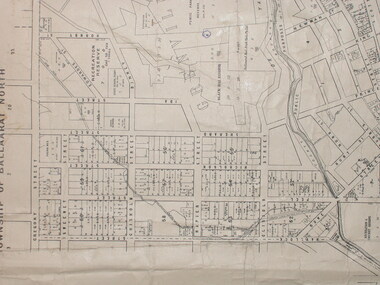
... Crown Cadastral Plan showing Governement Roads, Crown Parcels, Dimensions, Crown grantees, dated of grants, etc in Ballarat East. ...Barker Library (top floor) Mount Helen goldfields map plan ballarat east ballarat woollen mill ballarat railway line ballarat railway station eureka reserve eureka cemetery ballarat orphanage russell square bakery hill Crown Cadastral Plan showing Governement Roads, Crown Parcels, Dimensions, Crown grantees, dated of grants, etc in Ballarat East. ...Crown Cadastral Plan showing Governement Roads, Crown Parcels, Dimensions, Crown grantees, dated of grants, etc in Ballarat East. The plan shows features such as Bakery Hill, Canadian Station, recreation reserves, timber reserves, Yarrowee Creek, Black Hill Reserve, Eureka Reserve and Garden, Orphan Asylum, Rifle Butts Reserve, Ballarat Woollen Mill, Ballarat Observatory, Sovereign Hill Recreation Reserve, Specimen Vale, Market Reserve, Cemetery WGS 84 Centroid 37 degrees 33' 55" S 143 degrees 52' 38" E E.W. Extent; 5 km N-S Extent; 4 kmmap, plan, ballarat east, ballarat woollen mill, ballarat railway line, ballarat railway station, eureka reserve, eureka cemetery, ballarat orphanage, russell square, bakery hill -
 Ringwood and District Historical Society
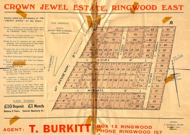
Memorabilia, History of "Jewel in the Crown" Estate, East Ringwood, Victoria, 1884-1947
... Collection of notes, titles and maps of "Jewel in the Crown" subdivision - Mount Dandenong Road (formerly Oxford Road), Velma Grove, Valda Avenue, Mirabel Avenue. ...Ringwood and District Historical Society 125A Warrandyte Road Ringwood North melbourne Carter Real Estate Agents sold some of the subdivision in 1946-47. This information was tied in with the early orcharding families. Collection of notes, titles and maps of "Jewel in the Crown ...Carter Real Estate Agents sold some of the subdivision in 1946-47. This information was tied in with the early orcharding families.Collection of notes, titles and maps of "Jewel in the Crown" subdivision - Mount Dandenong Road (formerly Oxford Road), Velma Grove, Valda Avenue, Mirabel Avenue. Genealogical charts of Meyland and Wigley families. 4 page history of the area compiled in 2004 by Richard Carter, Real Estate Agent. Registered Proprietors, Vendors, Property Title Holders and Transferees include: Herbert Edward WATSON, John Richard SHARP, Myrtle Evelyn BIRRELL, Marie Mathieson MUNRO, William Alex McCLELLAN, George Andrew GOODMAN, Joseph Tasman PEDRAZZI, Alexander ANDERSON, John Charles PATERSON, Eric William PHILLIPS, T.E.A. Co. Ltd., Florence Lavinia WYNARD, William John HARRIS, Lindsay and Hazel ALLNUTT, Douglas John RITCHIE, Eliza A.M. BOURBAND, Henrietta Irene COOK, Eric Edward COOK, Harold Thomas NICHOLLS, Stewart and Mary HIRD, Grace ROBINSON, Helen Rutherford GOOD, Henry Wyatt FARRELL, Irene Ann SMITH, Leslie Neil DOW, Helen Anne DOW, Frederick Ronald HOLDING, John Frederick McINTYRE, Horton Wilcox EDGE, Herbert James HARDINGHAM, Donald James ALLEN, Cyril Frederick WILLIAMS, Florence Sarah MAGGS, Maud Margaret PEARSON, Warwick Scott Holroyd MATTHEWS, Alice Eliza McCLEAVE, Leslie Archibald Charles HARRIS, Enid Beth HARRIS, Roy Victor DRAEGER, Elizabeth Ann STANDLEY, Charles Walter WATSON, Mabel Dorothy CARTER, Alan Garnett KELLY, Michael Vincent HARRIS, William Thomas Sylvester PROUD, Florence Blanche IVES, Douglas George PEARSON, Harry Clifford CLEGG, Dorothy Ellen Mary WHITE, Frederick Nathaniel EVANS, Madge EVANS, Leonard DUNSTAN, Violet Florence CONNELL, Valerie Jean Schimmelbusch, John Sydney COOK, William Donald THOMPSON, Ralph E RAUNSLEY, Murray McRae OSBORN, Francis William CLARKE, Alfred Daniel WILLIAMS, Harry Clifford CLEGG, Bernard Francis GARRY, Richard McKENZIE, Mignor Leonie WESTON, Idonea Moncrieffe DAVIS, Helen Marsden Rutherford GOOD, George SMART, Clement Henry DAVIS, Peter FINLAYSON, Elenor Leah HARVIE, Charles MEYLAND. -
 Warrnambool and District Historical Society Inc.
Book, Book Certificate of Titles A-Z Index, C 1890
... Warrnambool and District Historical Society Inc. 2 Gilles Street (south of Merri St) Warrnambool great-ocean-road This book contains certificates of title and Crown grants which record local changes of ownership.many are in the township of Warrnambool while others relate to areas such as Nullawarre, Purnim and Framlingham.These documents come under the Transfer of lands act of 1890. ...This book contains certificates of title and Crown grants which record local changes of ownership.many are in the township of Warrnambool while others relate to areas such as Nullawarre, Purnim and Framlingham.These documents come under the Transfer of lands act of 1890.This book has many local names and properties and is an historic link for the district.Brown heavy card cover with red fabric binding. It has an alphabetical index at the front followed by 200 pages of certificates of title.Descriptions of the land is written at the top of the pages with drawn and coloured diagrams below. The dates range from C 1878 to to C 1966. Some are certificate of title and others are Crown Grant. warrnambool, certificate of titles warrnambool 1900 -
 Warrnambool and District Historical Society Inc.
Book, Description & plans of title & grants
... Warrnambool and District Historical Society Inc. 2 Gilles Street (south of Merri St) Warrnambool great-ocean-road This book contains certificates of title and Crown grants which record local changes of ownership.many are in the township of Warrnambool while others relate to areas such as Nullawarre, Purnim and Framlingham. ...This book contains certificates of title and Crown grants which record local changes of ownership.many are in the township of Warrnambool while others relate to areas such as Nullawarre, Purnim and Framlingham. These documents come under the Transfer of lands act of 1890.The significance of this book lies in the many names and the land to which they were connected. Deep maroon paper over card cover with dark green fabric binding.Alphabetical index at the front followed by 200 pages which record details of the Certificates of title and Crown Grants from around the period of warrnambool, warrnambool history, certificate of title, crown grant warrnambool -
 Warrnambool and District Historical Society Inc.
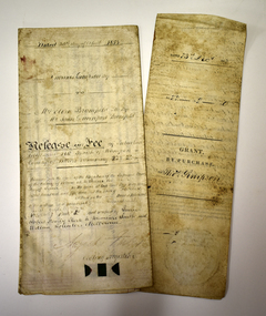
Legal record - Two documents regarding purchase and sale of land, George Barber, Port Fairy solicitor, early 1850s
... The first document, called a Grant by Purchase, is dated 1852 and shows that Thomas Simpson purchased from the Crown, Allotment 146 (22 acres two roods) adjoining the property of Wollaston on the Merri River and the Mortlake Road, north of Warrnambool. ...Warrnambool and District Historical Society Inc. 2 Gilles Street (south of Merri St) Warrnambool great-ocean-road Thes two documents deal with the purchase and sale of land near Warrnambool by Thomas Simpson. The first document, called a Grant by Purchase, is dated 1852 and shows that Thomas Simpson purchased from the Crown, Allotment 146 (22 acres two roods) adjoining the property of Wollaston on the Merri River and the Mortlake Road, north of Warrnambool. ...Thes two documents deal with the purchase and sale of land near Warrnambool by Thomas Simpson. The first document, called a Grant by Purchase, is dated 1852 and shows that Thomas Simpson purchased from the Crown, Allotment 146 (22 acres two roods) adjoining the property of Wollaston on the Merri River and the Mortlake Road, north of Warrnambool. The cost was 90 pounds. The second document is dated 1853 and shows that Thomas Simpson sold this Merri River allotment of 22 acres to Eliza Bromfield, in conjunction with her husband, John Davenport Bromfield, for the sum of 110 pounds. The property of Wollaston was owned by the Manifold family and in the 1850s was leased to William Simpson, the brother of Thomas who had an adjoining property called Wooramoota. John Davenport Bromfield was a Colac farmer who played a prominent part in the early history of that town. His brother James Astley Bromfield, an early chemist in Warrnambool is important in Warrnambool's history.These two items are of considerable significance because they are amongst the earliest legal documents we have connected to Warrnambool's history and because they concern three early pioneers of the district. They also have a connection to Wollaston, an important early property in the Warrnambool district..1 A piece of light parchment paper, stained with age and folded in three places. It contains printed and handwritten material, a copy of a signature and a white seal. .2 A piece of parchment paper folded in half and then folded again in two places. It contains ruled red lines, handwritten material in black ink and the remains of a red seal. The top of the first page has a cut-out fluted pattern.wollaston, john davenport bromfield, thomas simpson, eliza bromfield, george barber solicitor -
 Warrnambool and District Historical Society Inc.
Badge - Prince of Wales Badge 1920, 1920
... Warrnambool and District Historical Society Inc. 2 Gilles Street (south of Merri St) Warrnambool great-ocean-road This badge was issued in 1920 to commemorate the visit to Australia of Edward, Prince of Wales. It was issued to school children. The visit of the Prince of Wales was a gesture by the British Crown to recognize the sacrifices and efforts of the Australian people and defence forces during World War One. ...This badge was issued in 1920 to commemorate the visit to Australia of Edward, Prince of Wales. It was issued to school children. The visit of the Prince of Wales was a gesture by the British Crown to recognize the sacrifices and efforts of the Australian people and defence forces during World War One. Edward, Prince of Wales, later became King of England in 1936 and abdicated that same year. During the 1920 visit to Victoria the Prince of Wales came to Terang and stayed overnight at Glenormiston, near Terang, at that time the property of Cr Black, the President of the Shire of Hampden.This badge is of interest as a memento of a Royal visit to Victoria in 1920.This is a round metal badge with a black and white photograph of Edward, Prince of Wales on one side and a metal pin on the other side.visit to australia of prince of wales 1920, glenormiston homestead -
 Warrnambool and District Historical Society Inc.
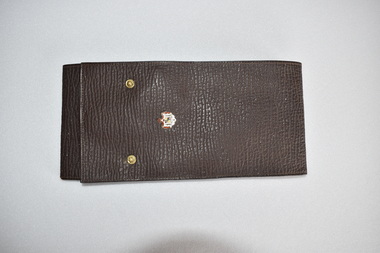
Colar Holder, Early 20th century
... Warrnambool and District Historical Society Inc. 2 Gilles Street (south of Merri St) Warrnambool great-ocean-road This collar holder would have been used in the early to mid 20th century in the days when men's shirts often had detachable collars so that the collars could be changed each day and the shirt part would not have to be washed so frequently. The metal crest on the holder with a crown ...This collar holder would have been used in the early to mid 20th century in the days when men's shirts often had detachable collars so that the collars could be changed each day and the shirt part would not have to be washed so frequently. The metal crest on the holder with a crown on top suggests that the wearer of the detachable collars could have held a Government office or been a member of one of the Defence Forces. This collar holder has no known local provenance but is kept as a memento of the days (80 to 100 years ago and more) when men wore shirts with detachable collars. This is a rectangular-shaped leather object which has been folded over once to form a wallet with an extra piece at the end to close over the wallet. The top piece closing device has two metal press studs. The insides of the wallet are lined with buff-coloured material hemmed with cotton stitching with two extra pieces folding over to hold the collars. The wallet contains one white collar with one collar stud. On the front of the wallet is gold-coloured printing and attached is a metal badge or crest. 'Soft Collars'men's vintage clothing, warrnambool, collar -
 Warrnambool and District Historical Society Inc.
Plate souvenir, Royal Copenhagen, New parliament house
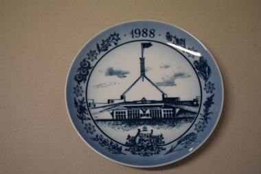
... Warrnambool and District Historical Society Inc. 2 Gilles Street (south of Merri St) Warrnambool great-ocean-road This item is a souvenir of the Bi- Centenary of Australia (1988) It features the new Parliament House in Canberra which was opened in May 1988 and cost more than one billion dollars to build and contains four thousand seven hundred rooms. This item came from the estate of a well known Warrnambool lawyer and is retained as a high quality souvenir of the Bi-Centenary of Australia parliament house bi centenary of australia Front 1988 Reverse ROYAL COPENHAGEN DENMARK and crown. ...This item is a souvenir of the Bi- Centenary of Australia (1988) It features the new Parliament House in Canberra which was opened in May 1988 and cost more than one billion dollars to build and contains four thousand seven hundred rooms. This item came from the estate of a well known Warrnambool lawyer and is retained as a high quality souvenir of the Bi-Centenary of AustraliaCircular ceramic plate. White concave surface with blue drawing of Parliament House, Australian Coat of Arms, flowers including banksia, Sturt Desert Pea, eucalypt and seven pointed stars. Reverse has raised inner rim and includes text in blue. Front 1988 Reverse ROYAL COPENHAGEN DENMARK and crown. COPYRIGHT THE A.B.A 1981 REG.TRADE MARK OF THE A.B.A. USED UNDER LICENCE BY ROYAL COPENHAGEN NEW PARLIAMENT HOUSE, CANBERRA Logo Australia 1788-1988 Signature " Gorn Uestezaul"(?)parliament house, bi centenary of australia -
 Warrnambool and District Historical Society Inc.
Coin, English Penny Victoria Det Gratia 1854, 1854
... Warrnambool and District Historical Society Inc. 2 Gilles Street (south of Merri St) Warrnambool great-ocean-road English currency before decimalisation in the 1970's consisted of pounds, shillings and pence with twelve pennies to the shilling and twenty shillings to the pound.Coins ranged from farthings which were one quarter of a penny through to pennies, threepence, sixpence, shillings ,half crowns and crowns. ...English currency before decimalisation in the 1970's consisted of pounds, shillings and pence with twelve pennies to the shilling and twenty shillings to the pound.Coins ranged from farthings which were one quarter of a penny through to pennies, threepence, sixpence, shillings ,half crowns and crowns. Most coins had a variety of common names such as a " bob" for a shilling a "quid for a pound and a tanner for a sixpence. This coin is the equivalent of five shillings and is known as a crown. The text around the obverse, "Victoria Dei Gratia 1844". On the reverse the text of Reg Fid Def"Britanniar translates as Queen of Britain and defender of the faith. This coin is one of the smaller denominations.A common currency coin which has social and historical significance.Round copper coin with flat edge. The The obverse has an image of the young Victoria with text around the edge.The reverse has an image of Brittania in a chariot.Dotted edge around the inside rim of both sides.BRITTANNIAR REG FID DEFon the reverse and Victoria Dei gratia on the obverse.english penny, 1854 penny -
Warrnambool and District Historical Society Inc.
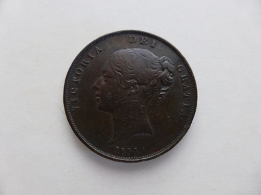
Numismatics, Coin :English Crown 1844, 1844
... Warrnambool and District Historical Society Inc. 2 Gilles Street (south of Merri St) Warrnambool great-ocean-road English currency before decimalisation in the 1970's consisted of pounds, shillings and pence with twelve pennies to the shilling and twenty shillings to the pound.Coins ranged from farthings which were one quarter of a penny through to pennies, threepence, sixpence, shillings ,half crowns and crowns. ...English currency before decimalisation in the 1970's consisted of pounds, shillings and pence with twelve pennies to the shilling and twenty shillings to the pound.Coins ranged from farthings which were one quarter of a penny through to pennies, threepence, sixpence, shillings ,half crowns and crowns. Most coins had a variety of common names such as a " bob" for a shilling a "quid for a pound and a tanner for a sixpence. This coin is the equivalent of five shillings and is known as a crown. The text around the obverse, "Victoria Dei Gratia 1844". On the reverse the text of Regina Fid Def"Britanniarum translates as Queen of Britain and defender of the faith.The text around the edge, DECUS ET TUTAMEN ANNO REGNI VIII translates as " an ornament and a safeguard. Coins were thus stamped in an effort to reduce the incidence of penny pinching whereby small amounts of precious metal were shaved from the edge of coins and still passed as full value coins.This coin was minted in the eighth year of the reign of one of England's longest ruling monarchs.It is of historical and social significance with the study of coins having considerable interest for many people. Large silver coin with image of Queen Victoria on the obverse or heads side of the coin and a coat of arms with crown at the top surrounded by a wreath of leaves is on the reverse. Text is around the edge of both sides with text also stamped into the edge of the coin as well. Obverse " Victoria Dei Gratia 1844." Reverse "Regina Fid Def"Britanniarum"On edge of coin is "DECUS ET TUTAMEN ANNO REGNI VIII english coins, coin half crown, english coin crown, warrnambool -
 Warrnambool and District Historical Society Inc.
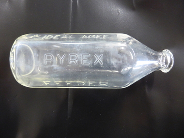
Bottle, The Perfect Agee Feeding Bottle, Mid 20th century
... Warrnambool and District Historical Society Inc. 2 Gilles Street (south of Merri St) Warrnambool great-ocean-road This baby’s feeding bottle was made by Agee (Australian Glass Manufacturers) and marketed by the Crown Crystal Glass Company. ...This baby’s feeding bottle was made by Agee (Australian Glass Manufacturers) and marketed by the Crown Crystal Glass Company. It is made of pyrex which is a brand of glass first produced by Corning Inc. of America in 1908. Pyrex is a clear low-thermal-expansion borosilicate glass used for laboratory glassware and kitchenware. The use of pyrex bottles became more prevalent in Australia in the second half of the 20th century and baby’s bottles made of pyrex were popular as they were easily sterilised in the home environment. This baby’s bottle has no known local provenance but it is retained because it is a good example of the advancement in infant health and welfare over the past 80 years. This is a baby’s feeding bottle made of glass (pyrex). The body of the bottle is hexagonal-shaped (circular with rounded edges). It has a circular-shaped neck and an open top with a moulded glass around it. The bottle has no feeding nipple or stopper. There are measurement marks on the side of the bottle up to 8 ounces. ‘The Ideal Agee Pyrex Feeder’ ‘AGM 1S 1561 6’ infant welfare, history of warrnambool -
 Warrnambool and District Historical Society Inc.
Bottle, Feeder Bottle Pyrex, Mid 20th century
... Warrnambool and District Historical Society Inc. 2 Gilles Street (south of Merri St) Warrnambool great-ocean-road This baby’s feeding bottle was made by Agee (Australian Glass Manufacturers) and marketed by the Crown Crystal Glass Company. ...This baby’s feeding bottle was made by Agee (Australian Glass Manufacturers) and marketed by the Crown Crystal Glass Company. It is made of pyrex which is a brand of glass first produced by Corning Inc. of America in 1908. Pyrex is a clear low-thermal-expansion borosilicate glass used for laboratory glassware and kitchenware. The use of pyrex bottles became more prevalent in Australia in the second half of the 20th century and baby’s bottles made of pyrex were popular as they were easily sterilised in the home environment. This baby’s bottle has no known local provenance but it is retained because it is a good example of the advancement in infant health and welfare over the past 80 years. This is a baby’s feeding bottle made of glass (pyrex). The body of the bottle is hexagonal-shaped (circular with rounded edges). It has a circular-shaped neck and an open top with a moulded glass around it. The bottle has no feeding nipple or stopper. There are measurement marks on the side of the bottle up to 8 ounces.‘The Ideal Agee Pyrex Feeder’ ‘AGM 1S 1561 6’ infant welfare, history of warrnambool -
 Warrnambool and District Historical Society Inc.
Map - Maps, Soldiers Settlement WW2, Circa 1950
... Warrnambool and District Historical Society Inc. 2 Gilles Street (south of Merri St) Warrnambool great-ocean-road The soldiers' settlement scheme operated after the first and second world wars in an effort to more closely settle the land and also give opportunities to returned soldiers. Crown ...The soldiers' settlement scheme operated after the first and second world wars in an effort to more closely settle the land and also give opportunities to returned soldiers. Crown land and other larger estates were acquired for the purpose. Most of these maps relate to the area north of Warrnambool where many of the subdivisions were parts of larger estates.These maps pertaining to the Soldiers' Settlement program, relate to an interesting part of Australian and local history. As such they have historic and social interest and significance.A collection of 25 paper maps which relate to to the soldiers settlement post World War 2. Some have details of the people allocated the land and some smaller maps have the printed details of the applicants requirements.Text is black on white paper which in some cases is quite aged. The maps are as follows: .1 Narrapumelap Estate ( Ripon & Hampden) .2 Narrapumelap Estate Part 2 (Villers & Ripon) .3 Narrapumelap Estate Part 3 ( Villiers & Ripon) .4 Burrumbeet Estate ( Ripon) .5 ' Berrambool' Estate 9 Hampden & Villiers) .6 ' Hopkins Hill' Estate Villiers 4011 acres .7 Caramut North No 2 Estate ( Villiers ) .8 ' Morpor' Estate ( Villiers) 4172 acres .9 ' Morgiana' Estate ( Normandy) 3453 acres .10 ' Chatsworth House' ( Villiers) 9341 Acres .11 ' East Elwood' Estate Villiers 2407 acres .12 Grey's Estate ( Mornington) 1151acres .13 ' Rowes Estate' ( Buln Buln Gippsland 733 acres .14 'Tarrone' Estate No 2 Part map .15 'Chaldon Meade' Estate (Bourke) Bulla 517 acres .16 ' Terranallum South' Estate Hampden 3757 acres .17 ' Brung Brungle' Estate Dundas 695 .18 ' Armidale ' Estate ( Dundas)2108 acres .19 ' Moyne Falls' Estate ( Villiers) 627 acres .20' Yulong' Estate 9 Lowan 6321 acres .21 Murray Valley Irrigation District 9 Moira)113 acres .22 Murray Valley Irrigation District 103 acres .23 ' Mount Fyans' Estate ( Hampden) .24 ' Barwidgee ' Estate ( Villiers) 4277 acres .25 'Pine Hills' Estate 2nd portion ( Lowan) 6190 acres narrapumelap, berrambool, hopkins hill, caramut north, morpor, chatsworth house, east elwood, terrinallum, moyne falls, tarrone, caramut soldiers settlers, burrumbeet, morgiana, grey's estate mornington, chaldon meade, brung brungle -
 Warrnambool and District Historical Society Inc.
Documents, Late 20th, early 21st centuries
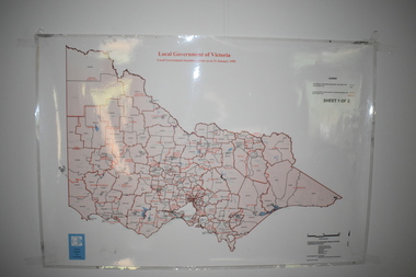
... It is printed in black and white. .5 This is a 2006 coloured aerial photograph of the harbour at Warrnambool – Breakwater etc. .6 This is a 2006 coloured aerial photograph of the Lake Pertobe area in Warrnambool .7 This is a coloured aerial photograph of Warrnambool’s streets over-stamped with road numbers in large blockings. .8 This is a plan showing the title details of Section 11 in Warrnambool. It has black printing on buff-coloured paper. .9.1 This is a plan of sub-divisions in parts of Crown Allotments 38 & 39 in Warrnambool. ...It is printed in black and white. .5 This is a 2006 coloured aerial photograph of the harbour at Warrnambool – Breakwater etc. .6 This is a 2006 coloured aerial photograph of the Lake Pertobe area in Warrnambool .7 This is a coloured aerial photograph of Warrnambool’s streets over-stamped with road numbers in large blockings. .8 This is a plan showing the title details of Section 11 in Warrnambool. It has black printing on buff-coloured paper. .9.1 This is a plan of sub-divisions in parts of Crown Allotments 38 & 39 in Warrnambool. ...These ten documents (maps, plans, photographs) mostly come from the Warrnambool City Council and most contain information on sub-divisions and titles of properties in areas around the Central Business District of Warrnambool. The dates range from 1986 to 2006. These maps, plans and photographs are of some interest as they give historical details of subdivisions in Warrnambool and date from the late 20th century. .1 This is a laminated map of the boundaries of Local Governments in Victoria. It is Sheet I of 2 and has red and blue pencil markings and black boundary markings. .2 This is a copy of a plan of a survey in black and white markings on paper. .3 This is a plan of the title details of Section 19 Warrnambool. It has black printing on buff-coloured paper. .4 This is a plan of the allotments in part of the Central Business District of Warrnambool. It is printed in black and white. .5 This is a 2006 coloured aerial photograph of the harbour at Warrnambool – Breakwater etc. .6 This is a 2006 coloured aerial photograph of the Lake Pertobe area in Warrnambool .7 This is a coloured aerial photograph of Warrnambool’s streets over-stamped with road numbers in large blockings. .8 This is a plan showing the title details of Section 11 in Warrnambool. It has black printing on buff-coloured paper. .9.1 This is a plan of sub-divisions in parts of Crown Allotments 38 & 39 in Warrnambool. It has green, pink and yellow markings with black printing. .9.2 This is a plan of the sub-divisions in parts of Allotments 38 & 39 in Warrnambool. It has pink, yellow and blue markings with black printing. It is somewhat faded. warrnambool c.b.d. maps and plans, history of warrnambool