Showing 26 items matching "toll bridge"
-
![Studley Park [Toll] Bridge, Kew](/media/collectors/550653872162f11fb04854aa/items/579ebf04d0cdd117c4c0815f/item-media/579ebf3ad0cdd117c4c0953e/item-fit-380x285.jpg?cb=6) Kew Historical Society Inc
Kew Historical Society IncPhotograph, Studley Park [Toll] Bridge, Kew, 1870s
... Studley Park [Toll] Bridge, Kew......toll bridge...Following the opening of Johnston Street Bridge, declining tolls led to the Bridge falling into disrepair. ...The photograph shows the toll bridge (also known as the Penny Bridge) from the northern end...."P[enny] Toll Bridge - built 1857. from old photo"...Studley Park [Toll] Bridge, Kew Photograph Photograph ...‘Studley Park Bridge’ or ‘penny bridge’ linked Church Street in Abbotsford and what is now Yarra Bend Park. The privately constructed bridge opened in 1857, gaining its popular name from the toll charged at the Abbotsford end. The engineer of the 485ft wide bridge was Mr. Austin and the builder was ‘Mr Grant, who threw the bridge over the Niagara’. Following the opening of Johnston Street Bridge, declining tolls led to the Bridge falling into disrepair. Badly damaged by the flood of 1891, the Bridge was compulsorily acquired by the Government in 1899, and later dismantled and sold for firewood.This work forms part of the collection assembled by the historian Dorothy Rogers, that was donated to the Kew Historical Society by her son John Rogers in 2015. The manuscripts, photographs, maps, and documents were sourced by her from both family and local collections or produced as references for her print publications. Many were directly used by Rogers in writing ‘Lovely Old Homes of Kew’ (1961) and 'A History of Kew' (1973), or the numerous articles on local history that she produced for suburban newspapers. Most of the photographs in the collection include detailed annotations in her hand. The Rogers Collection provides a comprehensive insight into the working habits of a historian in the 1960s and 1970s. Together it forms the largest privately-donated collection within the archives of the Kew Historical Society.A print, taken in the 1960s by Dorothy Rogers, from an original albumen silver photograph now in the collection of the Kew Historical Society. The photograph shows the toll bridge (also known as the Penny Bridge) from the northern end."P[enny] Toll Bridge - built 1857. from old photo"studley park bridge, penny bridge, bridge, timber bridge, toll bridge -
 Kew Historical Society Inc
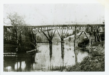
Print, Studley Pk Toll Bridge, July 12 1899
... Studley Pk Toll Bridge...toll bridges -- river yarra...bridges - yarra river -- kew (vic.)...penny bridge...Black and white print photograph of the wooden 'Penny Bridge' at Studley Park. The name was colloquially arrived at as a penny wa the toll one paid to cross the bridge. ...Reverse: "Studley Pk Toll Bridge / joining Church Street Abbotsford / Penny Bridge"...Studley Pk Toll Bridge Print ...Black and white print photograph of the wooden 'Penny Bridge' at Studley Park. The name was colloquially arrived at as a penny wa the toll one paid to cross the bridge. The copy of the postcard identifies the photographers as McAlpin Bros, Richmond.Reverse: "Studley Pk Toll Bridge / joining Church Street Abbotsford / Penny Bridge"toll bridges -- river yarra, bridges - yarra river -- kew (vic.), penny bridge -
 Wangaratta Historical Society
Toll Gates, Wangaratta Toll Bridge, Mid 19th Century
... Wangaratta Toll Bridge...Wangaratta Toll Gates were erected after the punt was sunk and the new bridge over the Ovens river was opened in 1855; a charge was made for people, animals, carts, cars and buses and trucks later on. ...Wangaratta Toll Gates Two white timber gates, hung on white timber posts by metal hinges. Wangaratta Toll Bridge Toll Gates ...Wangaratta Toll Gates were erected after the punt was sunk and the new bridge over the Ovens river was opened in 1855; a charge was made for people, animals, carts, cars and buses and trucks later on. A gatehouse keeper lived in a residence near the gates to charge users when they crossed. The gates were refurbished by the students at the local GOTAFE college and are being rehoused as a feature of the river beautification works along the Ovens River.The Toll Gates were on the first (and only bridge at the time) that crossed near the junction of the Ovens & King rivers at Wangaratta in the mid 1800's. They are a vital part of the city's heritage.Two white timber gates, hung on white timber posts by metal hinges. wangaratta toll gates -
 Phillip Island and District Historical Society Inc.
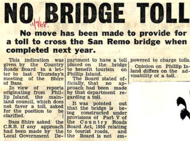
Newspaper Clipping, No Bridge Toll, 11/7/1968
... No Bridge Toll......bridge toll...Newspaper article about no move made to provide for a toll to cross the San Remo bridge when completed in 1969....No Bridge Toll Newspaper Clipping ...Article from a collection of newspaper clippings from October 1968 to July 1971Newspaper article about no move made to provide for a toll to cross the San Remo bridge when completed in 1969.phillip island, san remo bridge, bridge toll -
 Port Melbourne Historical & Preservation Society
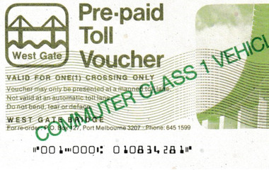
Document - Toll Ticket, West Gate Bridge, 7 Nov 1985
... Toll Ticket, West Gate Bridge...Port Melbourne Historical & Preservation Society Port Melbourne Town Hall 333 Bay Street Port Melbourne melbourne engineering - bridges lower yarra crossing authority Ticket for the value of 60c for one crossing of the West Gate Bridge, dated 7 Nov. 1985 Serial No. 100513 Document Toll Ticket, West Gate Bridge Lower Yarra Crossing Authority ...Ticket for the value of 60c for one crossing of the West Gate Bridge, dated 7 Nov. 1985 Serial No. 100513engineering - bridges, lower yarra crossing authority -
 Mont De Lancey
Booklet, Department of Main Roads, Toll Roads and Bridges, 1981
... Early toll roads and bridge use in Australia from early settlement days to 1981....Green and white edging surrounds the picture with the title Toll Roads and Bridges printed in black lettering at the top right of the cover. ...Road Tolls Roads Bridges History of tolls A brief history of tolls used throughout history, dating back around 1950 B.C. ...A brief history of tolls used throughout history, dating back around 1950 B.C. Early English and USA use is mentioned. Road and bridge tolls in Australia were collected for construction and maintenance of particular roads and bridges similar to their use in England. The clear photographs show the development in the this country up to 1981 when the brochure was published.A small slim rectangular paperback brochure with a lithograph of the "New Toll Gate" on Parramatta Road, published in J.G. Austin's Sydney Views. Green and white edging surrounds the picture with the title Toll Roads and Bridges printed in black lettering at the top right of the cover. On the back is a photograph of Toll cabins at the northern end of the Sydney Harbour Bridge showing automatic and manual toll booths with the symbol for NAASRA and National Association of Australian State Road Authorities printed in black and white at the bottom. Pp. 20. There are many photographs inside.non-fictionA brief history of tolls used throughout history, dating back around 1950 B.C. Early English and USA use is mentioned. Road and bridge tolls in Australia were collected for construction and maintenance of particular roads and bridges similar to their use in England. The clear photographs show the development in the this country up to 1981 when the brochure was published.road tolls, roads, bridges, history of tolls -
 Greensborough Historical Society
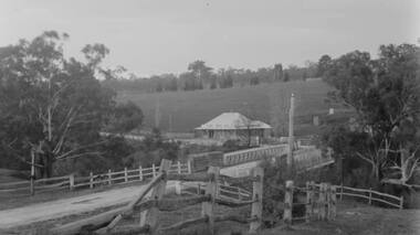
Photograph - Digital Image, Plenty Bridge Hotel, Lower Plenty, 1870s
... The hotel was built c1858 and the bluestone bridge in the 1860s to replace the earlier toll bridge built in 1858....The hotel was built c1858 and the bluestone bridge in the 1860s to replace the earlier toll bridge built in 1858. The close proximity of the hotel to the bridge is an indication of the importance of these river crossings in the mid 19th century lower plenty plenty river plenty bridge hotel lower plenty bridge lower plenty hotel Digital copy of black and white photograph Plenty Bridge Hotel, Lower Plenty Photograph - Digital Image ...Lower Plenty Hotel. This photograph shows the original Plenty Bridge hotel with Lower Plenty bridge in the foreground. The hotel was built c1858 and the bluestone bridge in the 1860s to replace the earlier toll bridge built in 1858.The close proximity of the hotel to the bridge is an indication of the importance of these river crossings in the mid 19th centuryDigital copy of black and white photographlower plenty, plenty river, plenty bridge hotel, lower plenty bridge, lower plenty hotel -
Kew Historical Society Inc
Archive (Sub-series) - Subject File, Bridges (Kew), 1958-present
... Bridges referred to and described in the file include Kanes Bridge, Walmer Street Foot Bridge, Johnston Street Bridge, Chandler Bridge, Collins Bridge, Tramway or Zig Zag Bridge, Penny Toll Bridge, Victoria Street Bridge, Burke Road Bridge. ...Bridges referred to and described in the file include Kanes Bridge, Walmer Street Foot Bridge, Johnston Street Bridge, Chandler Bridge, Collins Bridge, Tramway or Zig Zag Bridge, Penny Toll Bridge, Victoria Street Bridge, Burke Road Bridge. ...Various partiesReference, Research, InformationSecondary Values (KHS Imposed Order)Subject file containing information relating to each of the bridges crossing the Yarra In Kew. The file includes correspondence, photocopied photographs and maps, journal articles, research, and printed ephemera. Bridges referred to and described in the file include Kanes Bridge, Walmer Street Foot Bridge, Johnston Street Bridge, Chandler Bridge, Collins Bridge, Tramway or Zig Zag Bridge, Penny Toll Bridge, Victoria Street Bridge, Burke Road Bridge. The file includes original materials relating to the Victoria Street Bridge Centenary Celebration 1884-1984 -
 Port Melbourne Historical & Preservation Society
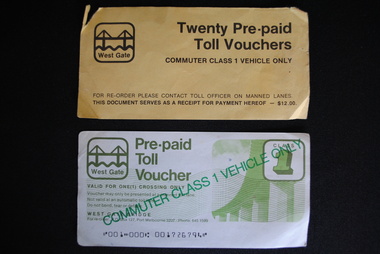
Document - Pre-paid Toll Vouchers for West Gate Bridge, 1980
... Pre-paid Toll Vouchers for West Gate Bridge. ...From the collection of Warren DOUBLEDAY. Bridge tolls were imposed from its opening in 1978 until they were removed in 1985....Port Melbourne Historical & Preservation Society Port Melbourne Town Hall 333 Bay Street Port Melbourne melbourne From the collection of Warren DOUBLEDAY. Bridge tolls were imposed from its opening in 1978 until they were removed in 1985. ...From the collection of Warren DOUBLEDAY. Bridge tolls were imposed from its opening in 1978 until they were removed in 1985.Two unused white Pre-paid Toll Vouchers.' Commuter Class 1 Vehicle Only' is written in green across both the front and back, The West Gate logo is in the top left corner.transport - motor vehicles, transport - roads, west gate bridge -
 Melbourne Tram Museum
Ephemera - Exercise Book, Keith Stodden, "Tickets 2", 1950's to 1980's
... Pages 1 - Sydney 2 - 5 - mixed VR Bus, MMTB, railway tours, National Trust, and other admission tickets 6 - 8 - Brisbane 9 - BTMS, TAA 10 - TMSV, Sydney 11 - MMTB 12 - Sandhurst Town, National Trust, mixed admission 13 - Sydney 14 - MMTB Bus 15 - Adelaide 16 - 19 - Brisbane 20 - 21- Melbourne Rail, 22 - Melbourne Pageant 23 - 24 - Melbourne Rail and Tram - Travel cards 25 - 26 - Auckland, MOTAT 27 - 28 - Travelcards, Ballarat, Bendigo, Perth, MMTB Swimming ticket 29 - Melbourne rail 30 - Ansett bus, rail and MTT Perth 31 - 32 - Rail travel cards 33 - CRB Westgate bridge toll, Neighbourhood tickets 34 - ARHS ACT, Westgate bridge toll vouchers, 35 - 37 - MMTB, Rail travel cards, ACT bus 38 - Muni, and Travelcard 39 - 40 - Rail, 41 - 42 - travel cards, ARHS ACT 43 - 44 - Travelcards, Santa tram Bendigo 45 - blank 46 - VicRail country ticket, Ansett boarding pass 47 - Levers coachlines....Pages 1 - Sydney 2 - 5 - mixed VR Bus, MMTB, railway tours, National Trust, and other admission tickets 6 - 8 - Brisbane 9 - BTMS, TAA 10 - TMSV, Sydney 11 - MMTB 12 - Sandhurst Town, National Trust, mixed admission 13 - Sydney 14 - MMTB Bus 15 - Adelaide 16 - 19 - Brisbane 20 - 21- Melbourne Rail, 22 - Melbourne Pageant 23 - 24 - Melbourne Rail and Tram - Travel cards 25 - 26 - Auckland, MOTAT 27 - 28 - Travelcards, Ballarat, Bendigo, Perth, MMTB Swimming ticket 29 - Melbourne rail 30 - Ansett bus, rail and MTT Perth 31 - 32 - Rail travel cards 33 - CRB Westgate bridge toll, Neighbourhood tickets 34 - ARHS ACT, Westgate bridge toll vouchers, 35 - 37 - MMTB, Rail travel cards, ACT bus 38 - Muni, and Travelcard 39 - 40 - Rail, 41 - 42 - travel cards, ARHS ACT 43 - 44 - Travelcards, Santa tram Bendigo 45 - blank 46 - VicRail country ticket, Ansett boarding pass 47 - Levers coachlines. ...Exercise or Mapping book - Australian Mapping book, decorative cover with mathematical tables on the rear, plain paper, 48 pages holding tickets collected by Keith Stodden. Titled "Tickets 2". Tickets have been positioned using stamp hinges. Pages 1 - Sydney 2 - 5 - mixed VR Bus, MMTB, railway tours, National Trust, and other admission tickets 6 - 8 - Brisbane 9 - BTMS, TAA 10 - TMSV, Sydney 11 - MMTB 12 - Sandhurst Town, National Trust, mixed admission 13 - Sydney 14 - MMTB Bus 15 - Adelaide 16 - 19 - Brisbane 20 - 21- Melbourne Rail, 22 - Melbourne Pageant 23 - 24 - Melbourne Rail and Tram - Travel cards 25 - 26 - Auckland, MOTAT 27 - 28 - Travelcards, Ballarat, Bendigo, Perth, MMTB Swimming ticket 29 - Melbourne rail 30 - Ansett bus, rail and MTT Perth 31 - 32 - Rail travel cards 33 - CRB Westgate bridge toll, Neighbourhood tickets 34 - ARHS ACT, Westgate bridge toll vouchers, 35 - 37 - MMTB, Rail travel cards, ACT bus 38 - Muni, and Travelcard 39 - 40 - Rail, 41 - 42 - travel cards, ARHS ACT 43 - 44 - Travelcards, Santa tram Bendigo 45 - blank 46 - VicRail country ticket, Ansett boarding pass 47 - Levers coachlines.trams, tramways, tickets, the met, mmtb, adelaide, sec, tmsv, sydney, buses -
 Warrnambool and District Historical Society Inc.
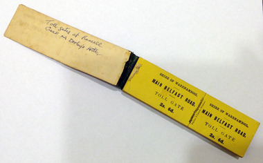
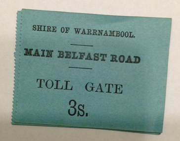
Certificate - Ticket Book, Main Belfast Road Toll, 2s 6d, 1860s
... There were three toll gate locations – on the main Belfast (Port Fairy) Road at Dennington Bridge, on the Woodford Road at Russells Creek and on the Geelong Road at the Allansford Bridge. ...There were three toll gate locations – on the main Belfast (Port Fairy) Road at Dennington Bridge, on the Woodford Road at Russells Creek and on the Geelong Road at the Allansford Bridge. ...The Shire of Warrnambool operated toll gates from 1866 to 1869 as a means of revenue rai sing for road construction. There were three toll gate locations – on the main Belfast (Port Fairy) Road at Dennington Bridge, on the Woodford Road at Russells Creek and on the Geelong Road at the Allansford Bridge. The toll gates were unpopular and unprofitable for the lessees as travellers were able to avoid the tax by skirting around the gates. They had toll houses besides the gates. The printers of these tickets, Fairfax and Laurie were the lessees at the time of the Warrnambool Examiner newspaper. This paper, founded by Richard Osburne and John Wilkinson, and published with some gaps from 1851 to 1880, is a key source today of Warrnambool’s history at that time. These toll gates tickets are significant because:- 1. They date back to the 1860s and were only issued from 1866 to 1869. 2. They are the only artefacts we hold of the time when toll gates were operating in our local district 3. They are the best example of how the Shire of Warrnambool in its early history raised revenue for road building and maintenance This is a book of toll gate tickets for sale at the Main Belfast (Port Fairy) Road Toll Gate. The tickets (about 50) are yellow and in duplicate with provision to detach the outer ticket for the purchaser to keep. The tickets (two shillings and sixpence) are bound with an adhesive tape and the cover is mottled in pattern (brown and blue). There are also four loose tickets in blue (3 shillings). Back Cover: ‘136’ Tickets in book: ‘Shire of Warrnambool, Main Belfast Road, Toll Gate 2s 6d., Fairfax and Laurie, Printers’ Loose tickets: ‘Shire of Warrnambool, Main Belfast Road, Toll Gate, 3s.’ shire of warrnambool, toll gates -
 Warrnambool and District Historical Society Inc.
Document - Main Belfast Road Toll Gate Ticket Collection, 1860s
... There were three toll gate locations – on the main Belfast (Port Fairy) Road at Dennington Bridge, on the Woodford Road at Russells Creek and on the Geelong Road at the Allansford Bridge. ...There were three toll gate locations – on the main Belfast (Port Fairy) Road at Dennington Bridge, on the Woodford Road at Russells Creek and on the Geelong Road at the Allansford Bridge. ...The Shire of Warrnambool operated toll gates from 1866 to 1869 as a means of raising revenue for road construction. There were three toll gate locations – on the main Belfast (Port Fairy) Road at Dennington Bridge, on the Woodford Road at Russells Creek and on the Geelong Road at the Allansford Bridge. The toll gates were unpopular and unprofitable for the lessees as travellers were able to avoid the tax by skirting around the gates. They had toll houses besides the tollgates. The printers of these tickets, William Fairfax and Henry Laurie, were the lessees at the time of the Warrnambool Examiner newspaper. This paper, founded by Richard Osburne and John Wilkinson, and published with some gaps from 1851 to 1880, is a key source today of Warrnambool’s history at the time. These toll gate tickets are significant because:- 1. They date back to the 1860s and were only issued from 1866 to 1869 2. They are the only artefacts we hold of the time when toll gates were operating in our local district 3. They are the best example of how the Shire of Warrnambool in its early history raised revenue for road building and maintenance. These are eleven toll gate tickets, ten for the Belfast (Port Fairy) Road toll gate and one for the Woodford Road toll gate. One is mounted on a Swintons store label (6 pence) and four are mounted on cardboard (2 shillings, sixpence, and two shillings and sixpence) and six are loose (three shillings, two shillings and sixpence and threepence). The Belfast Road tickets are yellow, green, blue and cream and the Woodford Road one is white. All have black printing. There is also an undated newspaper cutting with information on the toll gate tickets. Belfast Tickets: Shire of Warrnambool, Main Belfast Road, Toll Gate and the price Woodford Road: Shire of Warrnambool, Woodford Road, Toll Gate, 1s 6d Six of the eleven tickets also have ‘Fairfax and Laurie, Printers’ The sixpence ticket on card has the name R P Christian in ink written on the back of the card. shire of warrnambool, toll gates, r p christian, woodford road, main belfast road, swintons pty ltd -
 Eltham District Historical Society Inc
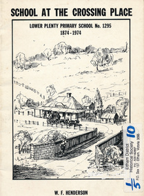
Book, School at the crossing place : Lower Plenty Primary School no. 1295, 1874-1974 / W.F. Henderson, 1974c
... Contents: Crossing Place Need for a school Residence for the teacher Closure A View of Lower Plenty 1918 Moving day at the Village The Golf Club Depression 1931 Vandals Electricity Grass Fires Cows at School Mothers' Club Women's liberation 1950's Lower Plenty after 1945 Swimming Pool - drowned dreams Long Grass - snakes - meadow hay - Fire Brigade The Royal Visit 1954 School Band Community Centre Our School Hall Trees and Gardens The Library Education 1874-1974 A Teacher's View The Second generation - children of ex-pupils (photo with names) The Third generation - Grandchildren of ex-pupils (photo with names) Head Teachers (list with dates) The Staff 1974 (photo with names) The sketch on the cover shows the Lower Plenty Bridge, toll house and the Plenty Bridge hotel, both no longer there. ...Contents: Crossing Place Need for a school Residence for the teacher Closure A View of Lower Plenty 1918 Moving day at the Village The Golf Club Depression 1931 Vandals Electricity Grass Fires Cows at School Mothers' Club Women's liberation 1950's Lower Plenty after 1945 Swimming Pool - drowned dreams Long Grass - snakes - meadow hay - Fire Brigade The Royal Visit 1954 School Band Community Centre Our School Hall Trees and Gardens The Library Education 1874-1974 A Teacher's View The Second generation - children of ex-pupils (photo with names) The Third generation - Grandchildren of ex-pupils (photo with names) Head Teachers (list with dates) The Staff 1974 (photo with names) The sketch on the cover shows the Lower Plenty Bridge, toll house and the Plenty Bridge hotel, both no longer there. ...23 pages including information on inside covers. Text with black and white illustrations and photographs and map. Contents: Crossing Place Need for a school Residence for the teacher Closure A View of Lower Plenty 1918 Moving day at the Village The Golf Club Depression 1931 Vandals Electricity Grass Fires Cows at School Mothers' Club Women's liberation 1950's Lower Plenty after 1945 Swimming Pool - drowned dreams Long Grass - snakes - meadow hay - Fire Brigade The Royal Visit 1954 School Band Community Centre Our School Hall Trees and Gardens The Library Education 1874-1974 A Teacher's View The Second generation - children of ex-pupils (photo with names) The Third generation - Grandchildren of ex-pupils (photo with names) Head Teachers (list with dates) The Staff 1974 (photo with names) The sketch on the cover shows the Lower Plenty Bridge, toll house and the Plenty Bridge hotel, both no longer there. The bridge is listed in the Banyule Heritage Study and has recently been restored by Banyule Council as a pedestrian bridge - NL 137 March 2001 Paperback; [24] p. : ill. ; 25 cm.lower plenty, state school no. 1295, lower plenty primary school -
 Melbourne Tram Museum
Document - Photo Album, Graeme Breydon, "Tickets and Postal Covers", c1970 to 1990
... Page 12 – four Red Bus Rover London tickets, four Peak Tramways tickets, one toll bridge, 6 London machine issued tickets. ...Page 12 – four Red Bus Rover London tickets, four Peak Tramways tickets, one toll bridge, 6 London machine issued tickets. ...Photo Album - dark blue plastic covers with the letters "photo album" in raised letters, stippled finish containing 10 leaves ring bound with an adhesive surface with clear plastic sheet on each cover. Page 1 – set of 8 Last day tram tickets – 16/4/1972 and four SEC tickets rear. Page 2 – set of 10 SEC tickets and 2 backs Page 3 – 2 BTPS 10c tickets, MMTB 25c, 3 Brisbane City Council tickets, two Trittons furnishings, one WCC (Wellington?) cable car and two MMTB City Concession tickets Page 4 – Set of 9 MMTB tickets 4d, 7d city, 7d, 8d, 1/-, 1/ 4, 2/- or 20c, 2/6 and one Pensioner’s check ticket. Page 5 – Set of 9 MMTB tickets, 4c, 8c, 9c, 10c, 30c, Pensioner’s concession, two $1 City concession cards, city concession check ticket and two machine issued tickets 1c and 15c. Page 6 – set of 16 MMTB tickets that have been recovered from within trams, very dirty, check tickets, value tickets and advertising on the rear. Page 7 – various special train tickets – Stainless steel train, ARHS tours, TMSV, ARHS Farewell, ARHS SA Mile End, Ballarat trams x 2, Crich exhibition ticket and one MTT (Tas?) 30c. Page 8 – VR Windsor to Melbourne Quarterly 1940, 7 VR various country and suburban tickets and two VR Motor coach services tickets. Page 9 – two interstate reserved seat tickets, Brisbane suburban ticket and 8 various values QR Parcel tickets – very dirty. Page 10 – Two Puffing Billy guest passes, 10th anniversary ticket, 10 various card tickets for Puffing Billy and tours. Page 11 – 6 + others MTT Adelaide value tickets with adverts on rear and four AETM St Kilda Museum tickets. Page 12 – four Red Bus Rover London tickets, four Peak Tramways tickets, one toll bridge, 6 London machine issued tickets. Page 13 – One San Francisco Municipal Railway ticket, one LlafrairPG platform ticket and two MMTB Machine tickets. Page 14 – One $1 MMTB city concession card and one Parramatta Park tramway ticket issued for COTMA during 1976. Page 15 – One Emerald Park vehicle entry ticket and one PBPS opening day of the extension to Lakeside in 1975 with certificate. Page 16 – One PBPS Notice. Page 17 – not used. Page 18 – three commemorative envelopes – WA Railway Centenary, Standard Gauge to Melbourne, and Sydney to Perth. Page 19 – Brisbane tramways last day, two Last day envelopes for Ballarat and Bendigo. Page 20 – three different St Kilda Centenary – Adelaide. Contained within the album was loose tickets - see Reg Item 3970 and a pamphlet for the opening of the Transport Mural at Spencer St Station on 30 Jan. 1978.has a label on the side in punched letters on a green tape "Tickets and Postal Covers"trams, tramways, tickets, secv, mmtb, adelaide, brisbane, arhs, aetm, aeta, pbps, cotma, tmsv, victorian railways, vr, post office, envelopes, post office -
 City of Melbourne Libraries
Photograph, Bull, Hugh Jones, 1897-1993, Princes Bridge Centenary pylons under construction
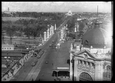
... This first bridge was a single span timber toll bridge designed by Scottish born bridge designer David Lennox, and completed in 1845. ...This first bridge was a single span timber toll bridge designed by Scottish born bridge designer David Lennox, and completed in 1845. ...Princes Bridge Centenary pylons under construction Possibly taken from Young and Jacksons Hotel (formerly Princes Bridge Hotel) on the corner of Flinders and Swanston streets, Flinders Street Station’s clocks and main entrance dominate, along with its distinctive copper dome and decorative façade. The time on the main clock is 1.40pm, and the sign underneath, reflecting Melbourne’s upcoming Centenary reads, “We must accommodate our Centenary visitors! Citizens! Do your share by taking paying guests.” At left is the original Princes Bridge Station, today the site of Federation Square. The riverside tram terminus advertises a Café/Tobacconist/Refreshment Room selling cigars & cigarettes, fountain drinks & confectionery, and in smaller text: “Leave your boot repairs here”. Nearly everyone is dressed in dark suits, coats and hats. The footpaths are wide and there are no traffic lights. The roadway stretches towards the Shrine of Remembrance, not yet dedicated but very dominant on the skyline. Government House is clearly visible across the wide parkland that would come to be known as Kings Domain and that is an area of deep importance to the people of the Eastern Kulin. Originally, Birrarung was part of a network of swamps and lagoons linked to the course of the river. From 1896, Public Works Department engineer Carlo Catani, oversaw a new channel to straighten the river and the swamps and lagoons were filled with spoil from the channel works. From the same vantage point today, only the top of the tower of Government House would be visible. The photo captures the pylons along Princes Bridge, mid-construction and being installed to mark Melbourne’s Centenary. The pylons were not without controversy. Both The Argus and The Age bemoaned them for being “made almost entirely of imported softwood timber”, denying work to native hardwood timber workers and sawmillers, and leading visitors to think Australia did not have its own exceptional native hardwoods. The pylons were also variously described in their incomplete state, as unimaginative and resembling an oilfield. Published: The Age 5 September 1934 Featured in "Newsworthy: Melbourne in photographs 1933-1936" exhibition at East Melbourne Library, October to December 2023. Exhibition caption by project volunteer, Louise McKenzie Photographer notations on slide: "Pylons + St Kilda Rd C57" Published: Age (Melbourne, Vic. : 1854 - 1954), Wednesday 5 September 1934, page 11 Published title: DECORATIONS -- THEN AND NOW. Published caption: "Although not completed yet, some impression of the effect of the decorations on Princes-bridge may be obtained from the first picture which shows the majestic sweep of St Kilda road with the Shrine of Remembrance and Government House dominating the horizon. The area to the left of St. Kilda-road and in front of Government House is portion of the area which it is proposed to call the King's Domain, which extends to Domain-road and Anderson-street..." Description: East-facing, elevated view of Flinders Street Station and Princes Bridge, featuring partially completed pylons erected for Melbourne's Centenary celebrations. The Shrine of Remembrance and Government House can be seen in the distance. In the foreground are trams, cars and trucks, pedestrians, Batman Avenue tram terminus and refreshment rooms. Signage on Flinders Street Station encourages citizens to accommodate Centenary visitors. The Melbourne Centenary was held 1934-35 in celebration John Batman's proclamation that Melbourne "the place for a village". Centenary events included a visit by Prince Henry, Duke of Gloucester. A Centenary Cake measuring 50 feet in height and ten tons in weight was cut into 250,000 pieces and sold at 1 shilling per piece for charity. Spectacular floodlighting of city landmarks, the creation of the Pioneer Women's Memorial Garden, and the MacRobertson Air Race from London, were other notable activities. Research by project volunteer, Louise McKenzie: The photo in The Age collage of 5 September 1934 has a slightly cropped foreground. The original photo has been taken from an elevated vantage point, most probably the roof of the Nicholas Building on the corner of Flinders and Swanston streets. The right foreground is dominated by the main “clocks” entrance to Flinders Street Station, showing its distinctive copper dome and decorative façade. The time on the main clock is 1.40 pm. The main sign on the front of the Station reads, "We Must Accommodate our Centenary Visitors! Citizens! Do your share by taking paying guests. Write to The Official Centenary Accommodation Bureau, 436 Collins St. City. Tel M 4671”. Another sign at eye level at the main entrance says: “Cheap Trips on Sundays”. The sign on the end of the roof along the eastern side of the station reads, “The Babies Need Your Help! Support Broadmeadows Foundling Hospital Appeal. July and August”. Run by the Sisters of St Joseph of the Sacred Heart, St Joseph’s Foundling Hospital was a purpose built infants’ home for up to 300 babies, plus accommodation for expectant mothers, mainly single women. In the early 1930s, the department (Victorian Children’s Welfare Department) contracted St Joseph’s Foundling Hospital to care for an additional 60 infant state wards, and up to 175 non wards at any given time. In 1931 it also operated a mothercraft training school. The centre foreground shows the commencement of Princes Bridge. Beneath the left side of the bridge was the site of the original Princes Bridge Station, by this time incorporated into Flinders Street Station, and today the area is the site of Federation Square. It was linked to Flinders Street station by the railway tracks that ran underneath the northern approach to the bridge. This photo shows a tram terminus which has a Café/Tobacconist/Refreshment Room, selling cigars & cigarettes, fountain drinks & confectionary, and a sign: Leave your boot repairs here. In the foreground is a wide roadway running south/north, comprising two vehicle lanes each heading north/south, and a central section containing two sets of tram tracks. There are cars, buses and delivery vans on the roadway. The trams visible are Glen Iris (Route No. 6; tram no. 448), Toorak (Route No. 8, tram no. 333), ? (No. 7), ? (No. 1), and ? (No. 2A). The footpaths are extremely wide. There is a square newspaper/magazine stand on the eastern side footpath. And also a “Ferry” sign. There are no traffic lights, but a policeman is visible on the roadway. There are pedestrians – men, women, children, a porter with trolley, women with prams. Clothing comprises dark suits, coats and hats for nearly everyone. There are double headed “Collins Street” lights along the side of the roadway, and along the northern riverbank. The roadway in the foreground is an extension of Swanston Street, which becomes Princes Bridge, then St Kilda Road, stretching towards the Shrine of Remembrance, and diverting past it. The Shrine had not yet been officially dedicated, and looks very white and dominant on the skyline. On the LHS of St Kilda Road, Government House is clearly visible across the wide parkland to be known as Kings Domain. The Kings Domain area is important to the people of the Eastern Kulin nation, and also has historical importance for its association with the early settlement of Melbourne and the foundation of British colonial administration in Victoria. On the southern side of the Yarra River (Birrarung) an historic rowing boathouse is visible, located adjacent to the Alexandra Gardens. Originally Birrarung was part of a network of swamps and lagoons linked to the course of the river. From 1896, under the guidance of engineer Carlo Catani* a new channel to straighten the river was created and the swamps and lagoons were filled with spoil from the channel works. The gardens were then created and completed in time for a Royal visit by the Duke of York in May 1901. The gardens are named after Alexandra of Denmark, the wife of King Edward VII. Both these areas, plus the Royal Botanic Gardens Victoria, Shrine of Remembrance Reserve, Sidney Myer Music Bowl, Government House, and the Queen Victoria Gardens together form the Domain Parklands. The extent of the subsequent plantings is evident today, where from the same vantage point only the top of the tower of Government House would be visible. *Catani was born in Florence in 1852, but after arriving in Melbourne worked as a civil engineer for the Victorian Government. His last major project was the reclamation of the foreshore of St Kilda, envisaged in the style of a European resort, complete with a split level esplanade, bathing pavilions, dance halls, amusements and a French-Italian style of landscape complete with palms. The gardens at the end of Fitzroy Street, St Kilda, now bear his name. The historic boathouse visible across the Yarra is another glimpse into Melbourne’s past. “Boathouse Row” comprises 7 amateur rowing clubs, the first established in 1859 (Melbourne University Boat Club). Other Clubs were Richmond, Melbourne, Banks, Melbourne Grammar School, Yarra Yarra and Mercantile. South of the river and west of the bridge is an area today developed into the Melbourne arts precinct of Hamer Hall and the Arts Centre. But at this time it was the home of Wirths Olympia Circus, which comprised Wirths Pleasure Park (an amusement park), a 5,000 seat auditorium – Hippodrome, a roller skating rink, a glaciarium, a cinema, and the Green Mill Dance Hall. Dog shows were also held at Olympia. The Green Mill Dance Hall closed in 1950, and the remainder of the Wirth buildings on site were destroyed by fire in December 1953. The feature of the photo is the pylons erected along Princes Bridge to mark Melbourne’s Centenary in 1934. The sixteen plastered pylons were designed by Roy Prentice, the second person to qualify as an architect at The University of Melbourne’s Bachelor of Architecture degree, in 1933, aged 27. Simon Reeves in his article marking the 100th birthday of Roy Prentice on 20 June 2006 reports that the State Electricity Commission sponsored this work, and the Argus reported that “… the pylons were “illuminated from within to give the effect of soft radiance”. Australia Home Beautiful 1 Oct 1934 reports in a very detailed and comprehensive article: The 10 taller pylons, including flagpole, were 48 ft, with a base of 8 ft. Timber-framed and faced with fibrous plaster and galvanised sheet iron, each structure was securely bolted to a concrete foundation three feet in depth. Panels of glass let into the shaft of each pylon were indirectly lit by 40, 100 watt lamps, and the upper bank of internal lamps were dyed so as to flood the panels with a deep red light. The decorative painted shields and flagpoles/pennants were illuminated by three 200 watt projectors concealed in the roof of each pylon, and were part of an electric night light decoration scheme involving 28 miles of wire to supply more than 20,000 lights. An article in the Argus on 18 October 1934 provided minute detail of the lighting erected in Melbourne for the Centenary, converting it “… into a coloured fairyland by night.” The estimated cost of 10 pounds per hour the lights were on. The display included 800 standard light poles 30 feet high which were tiered with electric bulbs concealed in inverted cones, 138 specially designed “Venetian poles” draped in flags trophies and streamers. The streets included in the electric night light decoration scheme were Bourke Street from Spring to William, the entire length of Collins Street, Flinders Street from Elizabeth to Spring, Lonsdale Street from Elizabeth to Swanston, Swanston and Elizabeth Streets from Flinders to Lonsdale, and parts of Springs and Spencer Streets. Together with the Princes Bridge pylons, approximately 28 miles of wire was required to supply power to the more than 20,000 lights. And that is just in the city of Melbourne. It was estimated the same amount of lighting was duplicated among other local councils. The pylons were not without controversy. The Argus on 28 August 1934 in an article headed “Imported Timber in Pylons” reported that the Princes Bridge pylons are “made almost entirely of imported softwood timber”, and have therefore denied work to native hardwood timber workers and sawmillers. The same day the Melbourne Age ran a similar story, bemoaning the fact that foreign oregon had been used which may lead tourists to think Australia did not have its own exceptional native hardwoods. A Camberwell City Councillor described the pylons as unimaginative, and the Herald reported that skeletons of pylons for the Centenary decorations in their present form led the area to resemble an oilfield! The Yarra River and Princes Bridge have long been a focal point of Melbourne life. In the early days of European settlement in Melbourne a rope-hauled punt carried people across the Yarra River. A surge in population and increased shipping traffic created a need for a bridge. There was difficulty in agreeing on a suitable site for the bridge (options were crossing at Elizabeth, Swanston, Queen or Market Streets), but the NSW Government favoured Swanston Street and the Melbourne Town Council decided on a temporary bridge across the Yarra spanning from the foot of Swanston Street. This first bridge was a single span timber toll bridge designed by Scottish born bridge designer David Lennox, and completed in 1845. It was 120 feet long, had a roadway of 17 feet wide, and a footpath on one side of 4 feet. It was leased to the Melbourne Bridge Company in the name of Robert A Balbirnie. The tollhouse was on the north side of the river and the toll keeper, Patrick Doherty, was credited with saving nine lives during the four years he was in charge of the toll station. The second bridge was stone (completed 1850), and named Prince’s Bridge after the HRH Prince of Wales, later Edward VII. It was designed with an elliptical single arc and an exceedingly small rise in proportion to the span. However, this design created an obstacle for flood waters, and together with Melbourne’s increasing population it was quickly apparent that a new bridge was required. At its opening on 15 November 1850 coincided with the imminent declaration of Victoria as a separate colony, it provided a moment of great celebration for Melbournians and “The opening ceremony was described as the grandest processional display witnessed in the colony.” (ToMelbourne.com.au) Princes Bridge in its present form, as depicted in this photograph, was designed by Jenkins, D’Ebro and Grainger, and constructed in 1886-88 by David Munro. John Grainger (father of Australian composer Percy Grainger) did the majority of the design work for the bridge. The structure was to have three arches each 96 feet wide measured across the river, and the banks on both sides were raised to allow more space for floodwater to flow. St Kilda Road was originally many feet below the current level. The bridge is of architectural significance for its substantial size, giant half columns, extensive use of wrought and cast iron, decorative elements (cast-iron lamps) and the skilled stonemasonry in the construction of the abutments and piers. Its main design features are similar to those of Blackfriars Bridge in London (1870). The bluestones were quarried from Footscray, the Malmsbury stones were from quarries at Kyneton, and the granite from Harcourt. The cost was met by the State of Victoria, City of Melbourne, and six out of seven of its municipalities, and their coats of arms feature on the bridge. The building of the bridge reflected the boom period of Melbourne, including the Victorian gold rush 1851- late 1860s, and its contractor, David Munro, was also responsible for the construction of Queens Bridge and Sandridge Railway Bridge. The Centenary pylons are no longer in place, but today this intersection still plays a major part in Melbourne’s daily life: people still meet “under the clocks” at Flinders Street station, and the route in and out of the city along St Kilda Road is often a feature of parades such as Moomba, the Grand Final Parade, and of course the Anzac Day Parade which commences at the Princes Bridge intersection and finishes at the Shrine of Remembrance. There are many tram routes, which cross the Bridge, and it directs pedestrians towards the Arts Precinct, the various components of Domain Park, plus the Southbank restaurant and rowing precincts. Even though this is a street scene, it feels very intimate; the viewer is instantly immersed in the activity of a Melbourne afternoon, looking down St Kilda Road from a viewpoint near today’s Federation Square. References: DECORATIONS -- THEN AND NOW. (1934, September 5). The Age (Melbourne, Vic. : 1854 - 1954), p. 11. Retrieved September 21, 2023, from http://nla.gov.au/nla.news-article205880269 'Flinders Street railway station', Wikipedia, https://en.wikipedia.org/wiki/Flinders_Street_railway_station 'St Joseph’s Foundling Hospital (1901-75)', Finding Records, Department of Health and Human Services, State of Victoria, https://www.findingrecords.dhhs.vic.gov.au/collectionresultspage/St-JosephsFoundling-Hospital-Babies-Home#departmental-administration 'Alexandra Gardens', City of Melbourne, https://www.melbourne.vic.gov.au/community/parks-open-spaces/major-parks-gardens/Pages/alexandra-gardens.aspx 'Wirths Circus', Wikipedia, https://en.wikipedia.org/wiki/Wirth's_Circus 'Roy Prentice: Centenary Architect', Built Heritage Pty Ltd, Simon Reeves, https://www.builtheritage.com.au/downloads/prentice.pdf 'Princes Bridge', Heritage Council Victoria, https://vhd.heritagecouncil.vic.gov.au/places/817 PORT PHILLIP. (1846, April 1). The Sydney Morning Herald (NSW : 1842 - 1954), p. 3. Retrieved September 21, 2023, from http://nla.gov.au/nla.news-article12886251 'Edward VII', Wikipedia, https://en.wikipedia.org/wiki/Edward_VII 'Princes Bridge', ToMelbourne.com, https://tomelbourne.com.au/princes-bridge/ 'Princes Bridge', eMelbourne, https://www.emelbourne.net.au/biogs/EM01189b.htm 'Princes Bridge', Australia for everyone, http://australiaforeveryone.com.au/files/melbourne/princes-bridge.html 'Victorian gold rush', Wikipedia, https://en.wikipedia.org/wiki/Victorian_gold_rush IMPORTED TIMBER IN PYLONS (1934, August 28). The Argus (Melbourne, Vic. : 1848 - 1957), p. 9. Retrieved September 21, 2023, from http://nla.gov.au/nla.news-article10952507 Princes-Bridge Pylons. (1934, August 28). The Age (Melbourne, Vic. : 1854 - 1954), p. 7. Retrieved September 21, 2023, from http://nla.gov.au/nla.news-article205532235 Pylons Appear Near Princes Bridge (1934, August 18). The Herald (Melbourne, Vic. : 1861 - 1954), p. 1. Retrieved September 21, 2023, from http://nla.gov.au/nla.news-article243104375 PRINCES-BRIDGE PYLONS. (1934, September 20). The Age (Melbourne, Vic. : 1854 - 1954), p. 10. Retrieved September 21, 2023, from http://nla.gov.au/nla.news-article205873535 28 Miles of Wire (1934, October 18). The Argus (Melbourne, Vic. : 1848 - 1957), p. 1 (The Junior Argus). Retrieved September 21, 2023, from http://nla.gov.au/nla.news-article10977836 'Historical references for Boathouse Row, Melbourne', http://boathouserowmelbourne.com.au/history/ 'ITALIAN DELEGATION TO HONOUR CARLO CATANI, DESIGNER OF THE ST KILDA FORESHORE, St Kilda Historical Society, 2001, https://web.archive.org/web/20070928061938/http://www.skhs.org.au/~SKHSarticles/articles/Carlo_Catani.html# HISTORY IN LIGHTS (1934, July 12). The Herald (Melbourne, Vic. : 1861 - 1954), p. 16. Retrieved September 21, 2023, from http://nla.gov.au/nla.news-article243172436 'Dressing Melbourne for the Duke', The Australian home beautiful: a journal for the home builder. Vol 12 No. 10 (1 October 1934), page 21, 58. Retrieved September 14, 2023, from http://nla.gov.au/nla.obj-2950922209Photographer notations on slide: "Pylons + St Kilda Rd C57".centenaries, bridges, lighting, flinders street railway station -
Marysville & District Historical Society
THE TRIANGLE NEWS-VOL 37 NO 45-DECEMBER 3 2010
... rain event toll on ut creek crossing...timber pedestrian bridge...Marysville & District Historical Society 39 Darwin Street Marysville yarra-valley-and-the-dandenong-ranges marysville victoria australia great victorian bike ride yea township community recovery fund murrindindi shire council yea high school students riding campaign rain event toll on ut creek crossing timber pedestrian bridge alexandra bowling club local lady golfers marysville golf club marysville morning tea soapbox advertisements marysville & district historical society agm vbbra grant collection management mary kenealy melbourne ballet company marysville cultural community events tool box marysville police news THE TRIANGLE NEWS-VOL 37 NO 45-DECEMBER 3 2010 ...marysville, victoria, australia, great victorian bike ride, yea township, community recovery fund, murrindindi shire council, yea high school, students riding campaign, rain event toll on ut creek crossing, timber pedestrian bridge, alexandra bowling club, local lady golfers, marysville golf club, marysville morning tea, soapbox, advertisements, marysville & district historical society agm, vbbra grant, collection management, mary kenealy, melbourne ballet company, marysville cultural community, events tool box, marysville police news -
Glen Eira Historical Society
Book - Local Government Act First Report of the Assistant Commissioner of Roads and Bridges
... Bridges in this period. In the Glen Eira area this includes: separating electoral subdivisions of single districts (Moorabbin), adding detached portions of territory to road districts and shires (Caulfield), appointing of and altering in polling places, appointing of polling places for ridings of shires and subdivisions of road districts (Moorabbin), preparing and transmitting of forms of books also of pro forma accounts for guidance of local bodies in keeping their accounts, appointment of main roads, construction of a main road, ‘Dandenong’, in the Caulfield and Gardiner districts, proclaiming of Common Toll Roads, names of and security given by Managers of Common Toll Roads. ...Bridges in this period. In the Glen Eira area this includes: separating electoral subdivisions of single districts (Moorabbin), adding detached portions of territory to road districts and shires (Caulfield), appointing of and altering in polling places, appointing of polling places for ridings of shires and subdivisions of road districts (Moorabbin), preparing and transmitting of forms of books also of pro forma accounts for guidance of local bodies in keeping their accounts, appointment of main roads, construction of a main road, ‘Dandenong’, in the Caulfield and Gardiner districts, proclaiming of Common Toll Roads, names of and security given by Managers of Common Toll Roads. ...This file contains 1 item: 1/The Local Government Act, First Report of the Assistant Commissioner of Roads and Bridges, printed by order of the Victorian Legislative Assembly on 08/03/1865. The document is the first annual report of John Steavenson, Assistant Commissioner of Roads and Bridges under s330 of the Local Government Act no. 176 (1863), and relates to transactions which took place from 02/09/1863 to 31/12/1864. The report outlines operations carried out by the Department of Roads and Bridges in this period. In the Glen Eira area this includes: separating electoral subdivisions of single districts (Moorabbin), adding detached portions of territory to road districts and shires (Caulfield), appointing of and altering in polling places, appointing of polling places for ridings of shires and subdivisions of road districts (Moorabbin), preparing and transmitting of forms of books also of pro forma accounts for guidance of local bodies in keeping their accounts, appointment of main roads, construction of a main road, ‘Dandenong’, in the Caulfield and Gardiner districts, proclaiming of Common Toll Roads, names of and security given by Managers of Common Toll Roads. The report also gives some information about the Shire of Caulfield, which contained 24 road districts and 340 rate payers in 8¼ square miles, and the Shire of Moorabbin, which contained 62 road districts and 713 rate payers in 30 square miles.local government act, assistant commissioner of roads and bridges, legislative council, caulfield historical soceity, steavenson john, sullivan j. f. the honourable, caulfield, moorabbin, road districts, point nepean road, nepean highway, dandenong road, princes highway, brown edwin, osher joseph, cosgrove john, ferres john, roads and bridges offices, caulfield roads district, moorabbin roads district, road construction and maintenance, roads and streets, acts of parliament -
 Eltham District Historical Society Inc
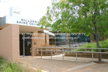
Photograph - Digital Photograph, Alan King, Nillumbik Shire Offices, Greensborough, 30 March 2008
... Secretary was the former committee’s secretary, Andrew Ross, Kangaroo Ground’s first school teacher, and founder of the district newspaper, The Evelyn Observer.2 Most of the board’s income came from a toll-house north of the Lower Plenty Bridge, which funded such projects as a road from Kangaroo Ground to the Caledonia Diggings. ...Secretary was the former committee’s secretary, Andrew Ross, Kangaroo Ground’s first school teacher, and founder of the district newspaper, The Evelyn Observer.2 Most of the board’s income came from a toll-house north of the Lower Plenty Bridge, which funded such projects as a road from Kangaroo Ground to the Caledonia Diggings. ...Nillumbik Shire Council transferred to the former Diamond Valley Shire Offices in Greensborough after municipal restructuing. The offices became the official Nillumbik Shire Council Offices on 16 October 1995. The former Shire of Diamond Valley Civic Centre or Shire Office building was officially opened on 26th February 1972. Archtiects were A.K. Lines, McFarlane & Marshall and it was built by L.U. Simon Pty Ltd, The Diamond Valley Shire had been created in 1964 from part of the City of Heidelberg. On December 15, 1994 the Shire of Nillumbik was established. Under the Council amalgamations imposed by the Kennett government, the Shire of Eltham, Shire of Diamond Valley and City of Heidelberg ceased to exist with the establishment of Nillumbik Shire Council and the City of Banyule.The new Nillumbik shire surrended the west riding from Eltham to Banyule but in place gained parts of the former Diamond Valley Shire which itself had been created in 1964 from parts of the City of Heidelberg. Three unelected and non-local Commissioners were put in place by the government bringing democracy into question by many members of the local community. The Commissioners determined to abandon the former Shire of Eltham offices located in Main Road, Eltham and in turn occupy the former Shire of Diamond Valley offices located at the boundary of the new shire with Banyule, in Civic Drive, Greensborough. In July 1996 the Commissioners sold the former Eltham Shire Offices and had them bulldozed leading to many years of communiity protest over the process and future development applications. The site has remained vacant ever since. Published: Nillumbik Now and Then / Marguerite Marshall 2008; photographs Alan King with Marguerite Marshall.; p43 It was the need for roads that led to this district’s first council. In 1853 a committee was formed to improve the rough roads, some in Kangaroo Ground being almost impassable in winter.1 The committee fundraised by voluntary levies and grants to improve in particular, the main road between Kangaroo Ground and the Plenty River. From this committee arose the Eltham District Road Board, in 1856, which was the precursor to the Eltham Shire Council. The Board’s first chairman was Kangaroo Ground farmer, John Barr. Secretary was the former committee’s secretary, Andrew Ross, Kangaroo Ground’s first school teacher, and founder of the district newspaper, The Evelyn Observer.2 Most of the board’s income came from a toll-house north of the Lower Plenty Bridge, which funded such projects as a road from Kangaroo Ground to the Caledonia Diggings. In 1871 the Shire of Eltham was proclaimed, with its boundaries the same as those of the Road Board, and Councillor A Donaldson of Kangaroo Ground was the first president. Eltham was at the southern tip of the shire, which extended north to Kinglake and east beyond Yarra Glen. In 1878, part of Kinglake was added to the shire, while the area east of Watts River, near Healesville was removed. In 1912, then again in 1958, the shire was further reduced. Yarra Glen, Steels Creek, Tarrawarra, parts of Healesville and Christmas Hills, were transferred to the Shire of Healesville. In 1972 a smaller area, at Kinglake, was transferred to the Shire of Yea, leaving 277 square kilometres in the Eltham Shire. Perhaps no other Victorian municipality has had so many meeting places. Although from 1858 to 1904, the council convened at the office in the home of Secretary Charles Wingrove, the board, and later the council, also met at other more central locations.3 The board moved from the Fountain of Friendship Hotel to the Eltham Courthouse, to the Kangaroo Ground schoolhouse. It then met at the Kangaroo Ground Hotel, which some considered put it in danger of interruptions by people ‘the worse for liquor’.4 In 1885 the council met at the hall on Mr J Donaldson’s land at Kangaroo Ground. After Wingrove’s retirement, the council rented space at the Kangaroo Ground General Store and Post Office. Then, in 1917, the council bought the former office of The Evelyn Observer, after its printing works transferred to Hurstbridge. In 1934, fire destroyed the shire office, which was temporarily relocated to the Kangaroo Ground home of Shire Secretary, Mr P J McMahon. In 1941, the shire office moved to a new building (which included a public hall) in Eltham, at the corner of Arthur Street and Main Road, where the Eltham Village Shopping Centre was eventually built. Growth required new offices, which opened in 1965, on the former Shillinglaw property in Main Road.5 In 1994, as part of municipal restructuring under the Jeff Kennett Liberal Government, most of the Eltham Shire formed part of the new Shire of Nillumbik. It joined with the north section of the Diamond Valley Shire and parts of the Healesville and Whittlesea municipalities. The Diamond Valley Shire had been created in 1964, from part of the City of Heidelberg. Turbulence followed Nillumbik Shire’s formation. Under the Commissioners the council transferred to the former Diamond Valley Shire offices in Greensborough, and the Eltham council offices were demolished. In March 1997 the first five-member Nillumbik Council was elected. But, in October 1998, the government suspended the council and appointed an administrator . Early in 1999, shire residents voted to increase councillors to nine: comprising five ward councillors and four shire-wide councillors. Elections were held in March 1999. Then, before the March 2002 elections, nine new wards were created.6 In 2008 these were reduced to seven. Today [2008] the council governs a varied population of more than 60,000 people living in townships and on bush properties in the green wedge.This collection of almost 130 photos about places and people within the Shire of Nillumbik, an urban and rural municipality in Melbourne's north, contributes to an understanding of the history of the Shire. Published in 2008 immediately prior to the Black Saturday bushfires of February 7, 2009, it documents sites that were impacted, and in some cases destroyed by the fires. It includes photographs taken especially for the publication, creating a unique time capsule representing the Shire in the early 21st century. It remains the most recent comprehenesive publication devoted to the Shire's history connecting local residents to the past. nillumbik now and then (marshall-king) collection, greensborough, nillumbik shire council offices, civic drive -
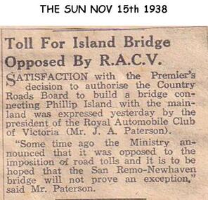 Phillip Island and District Historical Society Inc.
Newspaper clippings, 15/11/1938
... Article expressing opposition to tolls on Newhaven - San Remo Bridge...Phillip Island and District Historical Society Inc. phillip-island-and-the-bass-coast Newspaper article in The Sun local history documents newspapers bridges phillip island tolls black & white newspaper clipping j a paterson president of racv Article expressing opposition to tolls on Newhaven - San Remo Bridge Newspaper clippings ...Newspaper article in The SunArticle expressing opposition to tolls on Newhaven - San Remo Bridgelocal history, documents, newspapers, bridges, phillip island, tolls, black & white newspaper clipping, j a paterson president of racv -
 Eltham District Historical Society Inc
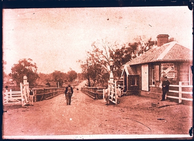
Photograph, Doug Orford, Lower Plenty Bridge, Old Eltham Road, Lower Plenty, 1998
... Originally the boundary between the former Shire of Eltham and the City of Heidelberg, a toll gate existed on the Eltham side. The bridge has since been restored and is now part of the Plenty River Trail....Eltham District Historical Society Inc 728 Main Rd Eltham melbourne Originally the boundary between the former Shire of Eltham and the City of Heidelberg, a toll gate existed on the Eltham side. The bridge has since been restored and is now part of the Plenty River Trail. bridges lower plenty main road plenty river Old Eltham Road Two colour photograph prints 10 x 15 cm (2 copies) Lower Plenty Bridge, Old Eltham Road, Lower Plenty Photograph Photograph Doug Orford ...Originally the boundary between the former Shire of Eltham and the City of Heidelberg, a toll gate existed on the Eltham side. The bridge has since been restored and is now part of the Plenty River Trail.Two colour photograph prints 10 x 15 cm (2 copies)bridges, lower plenty, main road, plenty river, old eltham road -
 Bendigo Historical Society Inc.
Document - BOARD OF WORKS, MELBOURNE: CONTRACTS ACCEPTED & LAND SALES FOR 1860
... Contracts accepted are for Raising and removing sunken ship Marilla; Removal of Toll-gate from Mount Alexander Road and re-erection of same at Middle Gully; Erection of toll-house on Melbourne/Ballarat Road near Ballan; Erection of toll-house on Bendigo Road at Kangaroo Flat; Castlemaine to Ballarat - Erection of toll-house at Campbell's Creek; Construction of 2870 chains of Lower Western Road, west of Camperdown; Erection of two bridges and other improvements on the Clunes to Amherst Road; Erection of timber bridge, & c., over Two-mile Creek - Beechworth to Bowman Forest; Formation of roadway at head of Buckland Gap - Beechworth to Bowman Forest; Construction of culvert, & c., Rowe's Creek - Beechworth to Bowman Forest; Ararat and South-western sea-board road - erection of bridge over Dennicull Creek and other improvements. ...History House 11 Mackenzie Street Bendigo goldfields BRIDGE Construction timber bridges Board of Works Melbourne - Contracts Accepted & Land Sales 'Marilla' F M Pingree Jno R Bailey Robert Heron John Gray Donald Ross Hector McLean C J Glynn and Co John Nicholls and Co Michael Cleary Thomas Cairncross Brown and Gibson Queen Victoria Mr William Perry Mr De Castella Willoughby Barker A F A Greeves Board of Land and Works Melbourne Page 2223 titled Contracts Accepted - (Series 1860). Contracts accepted are for Raising and removing sunken ship Marilla; Removal of Toll ...Page 2223 titled Contracts Accepted - (Series 1860). Contracts accepted are for Raising and removing sunken ship Marilla; Removal of Toll-gate from Mount Alexander Road and re-erection of same at Middle Gully; Erection of toll-house on Melbourne/Ballarat Road near Ballan; Erection of toll-house on Bendigo Road at Kangaroo Flat; Castlemaine to Ballarat - Erection of toll-house at Campbell's Creek; Construction of 2870 chains of Lower Western Road, west of Camperdown; Erection of two bridges and other improvements on the Clunes to Amherst Road; Erection of timber bridge, & c., over Two-mile Creek - Beechworth to Bowman Forest; Formation of roadway at head of Buckland Gap - Beechworth to Bowman Forest; Construction of culvert, & c., Rowe's Creek - Beechworth to Bowman Forest; Ararat and South-western sea-board road - erection of bridge over Dennicull Creek and other improvements. Land Sales - 4 Lots - Elsternwick, parish of Prahran, County of Bourke; 2 Lots - Dandenong, County of Bourke; 20 Lots - Lillydale, Parish of Yering, County of Evelyn, 1 suburban Lot - County of Evelyn, Parish of Yering; 1 Allotment - Romsey, County of Bourke, Parish of Lancefield; 5 Lots - County of Mornington, Parish of Langwarrin, and 2 Lots - County of Mornington, Parish of Fingal. Lots to be sold at the Auction Rooms of Mr. William Perry, Great Collins Street, Melbourne. A F A Greaves, President, Office of the Board of Land and Works, Melbourne.bridge, construction, timber bridges, board of works, melbourne - contracts accepted & land sales, 'marilla', f m pingree, jno r bailey, robert heron, john gray, donald ross, hector mclean, c j glynn and co, john nicholls and co, michael cleary, thomas cairncross, brown and gibson, queen victoria, mr william perry, mr de castella, willoughby, barker, a f a greeves, board of land and works melbourne -
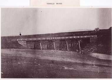 Clunes Museum
Photograph, PURCELL, ROGER, 1994
... TOLL HOUSE. A WELL BESIDE THE COTTAGE IS STILL NEAR THE ROAD. BESIDE THE NEW TOURELLO BRIDGE....TOLL HOUSE. A WELL BESIDE THE COTTAGE IS STILL NEAR THE ROAD. BESIDE THE NEW TOURELLO BRIDGE. local history photography photographs bridges .1 FRAMED PHOTOGRAPH OF TOURELLO BRIDGE ON BALLARAT RD. ...ORIGINAL PHOTOGRAPH OWNED BY MRS. LENA COOK OF CASTLEMAINE RD. CRESWICK.. THE PHOTOGRAPH WAS TAKEN LOOKING SOUTH WEST, THE SMALL COTTAGE SOUTH EAST OF HOLDING KNOWN AS 'STRAINS' ON THE CORNER OF BALLARAT AND COOK'S ROADS, MAY HAVE BEEN THE TOLL HOUSE. A WELL BESIDE THE COTTAGE IS STILL NEAR THE ROAD. BESIDE THE NEW TOURELLO BRIDGE..1 FRAMED PHOTOGRAPH OF TOURELLO BRIDGE ON BALLARAT RD. OVER COGHILLS CREEK. .2 BLACK & WHITE PHOTOGRAPH (COPY) .3 BLACK AND WHITE COPY OF ABOVE PHOTOGRAPHlocal history, photography, photographs, bridges -
 Anglesea and District Historical Society
Toll Vouchers, West Gate Bridge Authority, Estimated 1980
... 6 x Pre-paid Toll Vouchers valid for commuter class 1 vehicle only. Valid for one crossing of the West Gate Bridge. 1 x Cover (yellow) - Twenty Pre-paid Toll Vouchers. ...Pre-paid / Toll Vouchers / COMMUTER CLASS 1 VEHICLE ONLY / West Gate Bridge / Re-order - P.O. ...This doument serves as a receipt for payment hereof - $12.00. Toll Vouchers West Gate Bridge Authority ...6 x Pre-paid Toll Vouchers valid for commuter class 1 vehicle only. Valid for one crossing of the West Gate Bridge. 1 x Cover (yellow) - Twenty Pre-paid Toll Vouchers. Commuter Class 1 Vehicle Only. For Re-order please contact Toll Officer on Manned Lanes. This doument serves as a receipt for payment hereof - $12.00.Pre-paid / Toll Vouchers / COMMUTER CLASS 1 VEHICLE ONLY / West Gate Bridge / Re-order - P.O. Box 127, Port Melbourne 3207 Phone 645 1599. West Gate Bridge symbol. toll, pre-paid voucher, melbourne, transport freeways, road bridges, west gate -
Kew Historical Society Inc
Journal, Kew Historical Society, Newsletter No.115, June 2016
... More Examples of Lost Kew: Studley Park Toll Bridge, Salvation Army Citadel, Harp of Erin Hotel, Kew Recreation Hall p9. ...What Price Memory? / Robert Baker p1. What’s On - June to September: Exhibitions, Monthly meetings p3. Heritage Issues: Dorothy Rogers Reserve / Brad Miles p4. The Great War in Kew 1916: The conscription debate / Andrew Frost p6. Victorian Collections [Hat collection] / Robert Baker p7. More Examples of Lost Kew: Studley Park Toll Bridge, Salvation Army Citadel, Harp of Erin Hotel, Kew Recreation Hall p9. Membership & Donations p10.Published quarterly since 1977, the newsletters of the Kew Historical Society contain significant research by members exploring relevant aspects of the Victorian and Australian Framework of Historical Themes. Frequently, articles on people, places and artefacts are the only source of information about an aspect of Kew, and Melbourne’s history.non-fictionWhat Price Memory? / Robert Baker p1. What’s On - June to September: Exhibitions, Monthly meetings p3. Heritage Issues: Dorothy Rogers Reserve / Brad Miles p4. The Great War in Kew 1916: The conscription debate / Andrew Frost p6. Victorian Collections [Hat collection] / Robert Baker p7. More Examples of Lost Kew: Studley Park Toll Bridge, Salvation Army Citadel, Harp of Erin Hotel, Kew Recreation Hall p9. Membership & Donations p10. -
 Melbourne Tram Museum
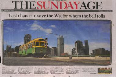
Newspaper, The Age, "Last chance to save the Ws, for whom the bell tolls", "Joy ride bid to save the W's for whom the bell tolls", "Something in sway means a ride back in time", "For the love of Melbourne's W class tram", 10/10/2010 12:00:00 AM
... tolls". Article looks at the future of the W class trams, a possible tourist route, union and crew viewpoints, Page 1 has a photo of SW6 884, crossing the Latrobe St bridge, written by Ruth Williams. ...tolls". Article looks at the future of the W class trams, a possible tourist route, union and crew viewpoints, Page 1 has a photo of SW6 884, crossing the Latrobe St bridge, written by Ruth Williams. ...Newspaper clipping - set of three different pages - from the Sunday Age 10/10/2010, titled "Last chance to save the Ws, for whom the bell tolls". Article looks at the future of the W class trams, a possible tourist route, union and crew viewpoints, Page 1 has a photo of SW6 884, crossing the Latrobe St bridge, written by Ruth Williams. Page 4 - "Joy ride bid to save the W's for whom the bell tolls" and "Something in sway means a ride back in time". Article written by John Elder and Craig Sillitoe. Page 16 - Editorial "For the love of Melbourne's W class tram" - promoting the retention of the trams, use for tourist services and upgrading them for use.trams, tramways, w class, sw6 class, save the w's, tram 884 -
 Williamstown Historical Society Inc
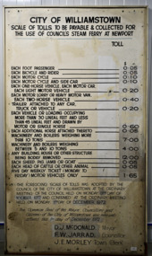
Sign - Sign - Williamstown/Port Melbourne Ferry toll sign
... tolls were approved by the Williamstown Council in 1972. The ferry was an important link to the north side of the lower Yarra River before the Westgate bridge opened in November 1978. ...tolls were approved by the Williamstown Council in 1972. The ferry was an important link to the north side of the lower Yarra River before the Westgate bridge opened in November 1978. ...This board indicated the tolls and fares for the Williamstown/Newport to Port Melbourne steam ferry. The tolls were approved by the Williamstown Council in 1972. The ferry was an important link to the north side of the lower Yarra River before the Westgate bridge opened in November 1978. It closed in January 1974, after a mechanical breakdown.Lare white enamelled board with black print listing tolls and fares in dollars and cents for vehicles and animals for the Williamstown/Newport to Port Melbourne steam ferry. The tolls have been changed over time, and are overwitten with new fares."CITY OF WILLIAMSTOWN/SCALE OF TOLLS TO BE PAYABLE AND COLLECTED FOR/THE USE OF COUNCIL’S STEAM FERRY AT NEWPORT"westgate bridge, newport ferry, williamstown ferry, yarra crossings