Showing 105 items matching "tourist facilities"
-
 Southern Sherbrooke Historical Society Inc.
Tourism information booklet, "Visit The Dandenongs", 1939
... ...tourist facilities...Southern Sherbrooke Historical Society Inc. 127 Colby Drive Belgrave Heights 3160 yarra-valley-and-the-dandenong-ranges tourism dandenongs tourist facilities photocopy of tourism booklet and typed letter from N.K.Gill, editor of Fern Tree Gully News, dated 8th June 1939, to Mr. ...photocopy of tourism booklet and typed letter from N.K.Gill, editor of Fern Tree Gully News, dated 8th June 1939, to Mr. A.R. Thomas, Selby, inviting interest in the publication of the booklet.tourism, dandenongs, tourist facilities -
 Kiewa Valley Historical Society
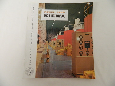
Booklet - S.E.C.V. x2, Power from Kiewa
... In this booklet there are photos of some of the major work constructions with an explanation of how they work and their purpose, a map of the Scheme and an article and photos of tourist facilities and activities that are available....In this booklet there are photos of some of the major work constructions with an explanation of how they work and their purpose, a map of the Scheme and an article and photos of tourist facilities and activities that are available. ...The State Electricity Commission of Victoria constructed the Kiewa Hydro Electric Scheme. Their public relations employees published booklets to promote the Scheme and the area. In this booklet there are photos of some of the major work constructions with an explanation of how they work and their purpose, a map of the Scheme and an article and photos of tourist facilities and activities that are available.This booklet promotes the Kiewa Hydro Electric Scheme and tourism indicating that tourism was recognised as a new industry for the area. The photos give a pictorial history of the area eg. skiing using the Summit T-bar lift and includes the facilities available at the time. The explanation of the Kiewa Hydro Electric Scheme is a basic resource for students interested in Hydro power.Slim booklet with photo of McKay Creek Power Station on the front cover and the title in brown and black at the top. Printed along the spine is State Electricity Commission of Victoria.state electricity commission of victoria. kiewa hydro electric scheme. tourism. t-bar ski tow. falls creek -
 Kiewa Valley Historical Society
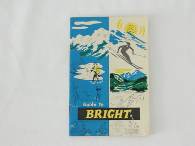
Pamphlet - Bright Tourism, Guide to Bright and District, late 1900s
... From the 1970s onwards, the increased tourism demand from overseas tourists, for better facilities and easier access to these regional facilities, resulted in better transport, accommodation and communication, which has been a boon for all tourism within Australia. ...From the 1970s onwards, the increased tourism demand from overseas tourists, for better facilities and easier access to these regional facilities, resulted in better transport, accommodation and communication, which has been a boon for all tourism within Australia. ...This publication was produced in the early 1950s to provide the growing tourism trade (at this time), to the region with a more detailed overview of the facilities available to tourists of the region's attractions. This brochure is a very efficient and effective promotional publication. The increasing level of self promotion by local business and commerce sectors of the region the more sought after the region became and the greater the ability of the region to grow (non rural based economy). Some of the regions unique facilities and geological structures are well suited to those tourists who live in cities and "flat land" regional bush areas within Australia. This was a period when the average Australian domestic tourist was more able (finance and transport wise) to see more of their country within the short time they had for "holidays". In the late 1900s, however, with the increase to workers' recreational leave and better transportation (fares, ease of travel to overseas destinations) the local tourism numbers from other domestic locations have been steadily declining. From the 1970s onwards, the increased tourism demand from overseas tourists, for better facilities and easier access to these regional facilities, resulted in better transport, accommodation and communication, which has been a boon for all tourism within Australia. In the 21st century the world is becoming smaller and smaller for the international tourist, especially for those from crowded Asian cities. The greater attraction for "open" spaced locations such as this region are becoming a much sought after change of scenery. This pamphlet which targets the tourist, whether either from other Australian regions or the global tourist, is a good example of self promotion by a relatively small local population. This is especially significant because before the "tourist explosion" in the 1950s onward, these regional areas had a more introspective society with greater emphasis to locally established mores and values. The increased interactions with people from other areas and nations, combined with a greater global communication network is affecting those traditionally established mores to produce a some what unique social transformation which is constantly changing from one generation to the next. One important factor which tourism does bring is that it opens up the region to a wider range of people who look to the region for their own lifestyle changes.This pamphlet has a front cover in colour with the major activities in the region sketched depicting : sunshine, snow skiing, trout fishing, mountain climbing, golfing, swimming, alpine views, tennis, lawn bowls and picnics. The back cover is blank. The pamphlet is fastened together by two staples 30mm from top and bottom, and is folded with the cover slightly thicker than the fifteen pages. Thirteen pages have been printed on both sides. The first page has a black and white photograph of the hotel Alpine and the tall brick constructed Clock Tower. There are another five black and white photographs in the pamphlet.on front cover "Guide to BRIGHT"local tourism, regional information booklet, "time" related brochures, alpine local history -
 Bendigo Historical Society Inc.
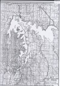
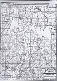
Map - Laminated map of Lake Eppalock at full capacity. Map 'E'
... The lake is a major attraction for those engaging in watersports, with a number of tourist parks and accommodation facilities available. Permissible activities on the lake include high-speed boating, water skiing, sailing, canoeing, fishing and swimming. ...The lake is a major attraction for those engaging in watersports, with a number of tourist parks and accommodation facilities available. Permissible activities on the lake include high-speed boating, water skiing, sailing, canoeing, fishing and swimming. ...John Perry Collection. Laminated map of Lake Eppalock at full capacity. Black and white. The dam was built by the State Rivers and Water Supply Commission of Victoria. The dam wall height is 45 metres (148 ft) and the main embankment is 1,041 metres (3,415 ft) long. At 100% capacity the dam wall was designed to hold back 304,651 megalitres (6.7014×10¹⁰ imp gal; 8.0480×10¹⁰ US gal) of water. The surface area of Lake Eppalock is 3,011 hectares (7,440 acres) and the catchment area is 2,124 square kilometres (820 sq mi). The controlled spillway is capable of discharging 8,040 cubic metres per second (284,000 cu ft/s). Lake Eppalock supplies both stock and domestic water to the Campaspe irrigation district. It also serves as a water supply to Bendigo and Heathcote and, in more recent times, Ballarat. The lake is a major attraction for those engaging in watersports, with a number of tourist parks and accommodation facilities available. Permissible activities on the lake include high-speed boating, water skiing, sailing, canoeing, fishing and swimming. The lake's water levels were low for approximately eight years between 2002 and 2010 during a prolonged drought, which restricted the amount of recreational activity until rainfall in the latter half of 2010 returned the lake to 100 percent capacity. Built between 1961 and 1964, Lake Eppalock remains the only water storage on the Campaspe River system.map, eppalock, water, dam, reservoir -
 Bendigo Historical Society Inc.
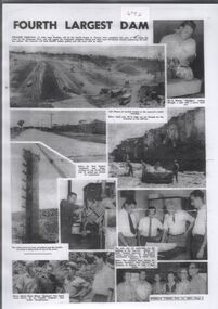
Document - Collection of photographs from newspaper on a single page
... The lake is a major attraction for those engaging in watersports, with a number of tourist parks and accommodation facilities available. Permissible activities on the lake include high-speed boating, water skiing, sailing, canoeing, fishing and swimming. ...The lake is a major attraction for those engaging in watersports, with a number of tourist parks and accommodation facilities available. Permissible activities on the lake include high-speed boating, water skiing, sailing, canoeing, fishing and swimming. ...John Perry Collection. Laminated copy of page from 'Weekly Times' newspaper, February, 1962. Nine images relating to establishing and building Eppalock Reservoir, 15 miles from Bendigo. The dam was built by the State Rivers and Water Supply Commission of Victoria. The dam wall height is 45 metres (148 ft) and the main embankment is 1,041 metres (3,415 ft) long. At 100% capacity the dam wall was designed to hold back 304,651 megalitres (6.7014×10¹⁰ imp gal; 8.0480×10¹⁰ US gal) of water. The surface area of Lake Eppalock is 3,011 hectares (7,440 acres) and the catchment area is 2,124 square kilometres (820 sq mi). The controlled spillway is capable of discharging 8,040 cubic metres per second (284,000 cu ft/s). Lake Eppalock supplies both stock and domestic water to the Campaspe irrigation district. It also serves as a water supply to Bendigo and Heathcote and, in more recent times, Ballarat. The lake is a major attraction for those engaging in watersports, with a number of tourist parks and accommodation facilities available. Permissible activities on the lake include high-speed boating, water skiing, sailing, canoeing, fishing and swimming. The lake's water levels were low for approximately eight years between 2002 and 2010 during a prolonged drought, which restricted the amount of recreational activity until rainfall in the latter half of 2010 returned the lake to 100 percent capacity. Built between 1961 and 1964, Lake Eppalock remains the only water storage on the Campaspe River system. dam, engineering, water, eppalock -
 Bendigo Historical Society Inc.
Document - Legend to maps A, B and C for Lake Eppalock
... The lake is a major attraction for those engaging in watersports, with a number of tourist parks and accommodation facilities available. Permissible activities on the lake include high-speed boating, water skiing, sailing, canoeing, fishing and swimming. ...The lake is a major attraction for those engaging in watersports, with a number of tourist parks and accommodation facilities available. Permissible activities on the lake include high-speed boating, water skiing, sailing, canoeing, fishing and swimming. ...John Perry Collection. Laminated 'legend' for Maps A, B and C for Lake Eppalock also in this collection. Black and White definitions and descriptions of objects and markers found on maps. Circa 1951. The dam was built by the State Rivers and Water Supply Commission of Victoria. The dam wall height is 45 metres (148 ft) and the main embankment is 1,041 metres (3,415 ft) long. At 100% capacity the dam wall was designed to hold back 304,651 megalitres (6.7014×10¹⁰ imp gal; 8.0480×10¹⁰ US gal) of water. The surface area of Lake Eppalock is 3,011 hectares (7,440 acres) and the catchment area is 2,124 square kilometres (820 sq mi). The controlled spillway is capable of discharging 8,040 cubic metres per second (284,000 cu ft/s). Lake Eppalock supplies both stock and domestic water to the Campaspe irrigation district. It also serves as a water supply to Bendigo and Heathcote and, in more recent times, Ballarat. The lake is a major attraction for those engaging in watersports, with a number of tourist parks and accommodation facilities available. Permissible activities on the lake include high-speed boating, water skiing, sailing, canoeing, fishing and swimming. The lake's water levels were low for approximately eight years between 2002 and 2010 during a prolonged drought, which restricted the amount of recreational activity until rainfall in the latter half of 2010 returned the lake to 100 percent capacity. Built between 1961 and 1964, Lake Eppalock remains the only water storage on the Campaspe River system.map, water, dam, reservoir, eppalock -
 Bendigo Historical Society Inc.
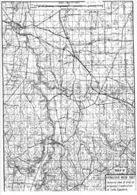
Map - General view of area of proposed construction of Lake Eppalock. Map 'A'
... The lake is a major attraction for those engaging in watersports, with a number of tourist parks and accommodation facilities available. Permissible activities on the lake include high-speed boating, water skiing, sailing, canoeing, fishing and swimming. ...The lake is a major attraction for those engaging in watersports, with a number of tourist parks and accommodation facilities available. Permissible activities on the lake include high-speed boating, water skiing, sailing, canoeing, fishing and swimming. ...John Perry Collection. Laminated map of proposed construction of Lake Eppalock. Map 'A'. Black and white map in laminate. Circa 1951. The dam was built by the State Rivers and Water Supply Commission of Victoria. The dam wall height is 45 metres (148 ft) and the main embankment is 1,041 metres (3,415 ft) long. At 100% capacity the dam wall was designed to hold back 304,651 megalitres (6.7014×10¹⁰ imp gal; 8.0480×10¹⁰ US gal) of water. The surface area of Lake Eppalock is 3,011 hectares (7,440 acres) and the catchment area is 2,124 square kilometres (820 sq mi). The controlled spillway is capable of discharging 8,040 cubic metres per second (284,000 cu ft/s). Lake Eppalock supplies both stock and domestic water to the Campaspe irrigation district. It also serves as a water supply to Bendigo and Heathcote and, in more recent times, Ballarat. The lake is a major attraction for those engaging in watersports, with a number of tourist parks and accommodation facilities available. Permissible activities on the lake include high-speed boating, water skiing, sailing, canoeing, fishing and swimming. The lake's water levels were low for approximately eight years between 2002 and 2010 during a prolonged drought, which restricted the amount of recreational activity until rainfall in the latter half of 2010 returned the lake to 100 percent capacity. Built between 1961 and 1964, Lake Eppalock remains the only water storage on the Campaspe River system.map, dam, water, weir, eppalock -
 Bendigo Historical Society Inc.
Map - Black and White map. Outline of Lake Eppalock. Map 'B'
... The lake is a major attraction for those engaging in watersports, with a number of tourist parks and accommodation facilities available. Permissible activities on the lake include high-speed boating, water skiing, sailing, canoeing, fishing and swimming. ...The lake is a major attraction for those engaging in watersports, with a number of tourist parks and accommodation facilities available. Permissible activities on the lake include high-speed boating, water skiing, sailing, canoeing, fishing and swimming. ...John Perry Collection. Laminated copy black and white map. Map 'B'. Outline of Lake Eppalcok, overlayed on map. Circa 1951. The dam was built by the State Rivers and Water Supply Commission of Victoria. The dam wall height is 45 metres (148 ft) and the main embankment is 1,041 metres (3,415 ft) long. At 100% capacity the dam wall was designed to hold back 304,651 megalitres (6.7014×10¹⁰ imp gal; 8.0480×10¹⁰ US gal) of water. The surface area of Lake Eppalock is 3,011 hectares (7,440 acres) and the catchment area is 2,124 square kilometres (820 sq mi). The controlled spillway is capable of discharging 8,040 cubic metres per second (284,000 cu ft/s). Lake Eppalock supplies both stock and domestic water to the Campaspe irrigation district. It also serves as a water supply to Bendigo and Heathcote and, in more recent times, Ballarat. The lake is a major attraction for those engaging in watersports, with a number of tourist parks and accommodation facilities available. Permissible activities on the lake include high-speed boating, water skiing, sailing, canoeing, fishing and swimming. The lake's water levels were low for approximately eight years between 2002 and 2010 during a prolonged drought, which restricted the amount of recreational activity until rainfall in the latter half of 2010 returned the lake to 100 percent capacity. Built between 1961 and 1964, Lake Eppalock remains the only water storage on the Campaspe River system.map, water, dam, reservoir, eppalock -
 Bendigo Historical Society Inc.
Map - Black and white map pertaining to Lake Eppalock
... The lake is a major attraction for those engaging in watersports, with a number of tourist parks and accommodation facilities available. Permissible activities on the lake include high-speed boating, water skiing, sailing, canoeing, fishing and swimming. ...The lake is a major attraction for those engaging in watersports, with a number of tourist parks and accommodation facilities available. Permissible activities on the lake include high-speed boating, water skiing, sailing, canoeing, fishing and swimming. ...John Perry Collection. Laminated copy of map relating to Lake Eppalock. Lists dwellings, ford crossings and bridges. The dam was built by the State Rivers and Water Supply Commission of Victoria. The dam wall height is 45 metres (148 ft) and the main embankment is 1,041 metres (3,415 ft) long. At 100% capacity the dam wall was designed to hold back 304,651 megalitres (6.7014×10¹⁰ imp gal; 8.0480×10¹⁰ US gal) of water. The surface area of Lake Eppalock is 3,011 hectares (7,440 acres) and the catchment area is 2,124 square kilometres (820 sq mi). The controlled spillway is capable of discharging 8,040 cubic metres per second (284,000 cu ft/s). Lake Eppalock supplies both stock and domestic water to the Campaspe irrigation district. It also serves as a water supply to Bendigo and Heathcote and, in more recent times, Ballarat. The lake is a major attraction for those engaging in watersports, with a number of tourist parks and accommodation facilities available. Permissible activities on the lake include high-speed boating, water skiing, sailing, canoeing, fishing and swimming. The lake's water levels were low for approximately eight years between 2002 and 2010 during a prolonged drought, which restricted the amount of recreational activity until rainfall in the latter half of 2010 returned the lake to 100 percent capacity. Built between 1961 and 1964, Lake Eppalock remains the only water storage on the Campaspe River system.map, water, dam, reservoir, eppalock -
 Bendigo Historical Society Inc.
Map - Black and white map pertaining to Lake Eppalock
... The lake is a major attraction for those engaging in watersports, with a number of tourist parks and accommodation facilities available. Permissible activities on the lake include high-speed boating, water skiing, sailing, canoeing, fishing and swimming. ...The lake is a major attraction for those engaging in watersports, with a number of tourist parks and accommodation facilities available. Permissible activities on the lake include high-speed boating, water skiing, sailing, canoeing, fishing and swimming. ...John Perry Collection. Laminated copy of map pertaining to Lake Eppalock. Gives details of dwellings, bridges and ford crossings. The dam was built by the State Rivers and Water Supply Commission of Victoria. The dam wall height is 45 metres (148 ft) and the main embankment is 1,041 metres (3,415 ft) long. At 100% capacity the dam wall was designed to hold back 304,651 megalitres (6.7014×10¹⁰ imp gal; 8.0480×10¹⁰ US gal) of water. The surface area of Lake Eppalock is 3,011 hectares (7,440 acres) and the catchment area is 2,124 square kilometres (820 sq mi). The controlled spillway is capable of discharging 8,040 cubic metres per second (284,000 cu ft/s). Lake Eppalock supplies both stock and domestic water to the Campaspe irrigation district. It also serves as a water supply to Bendigo and Heathcote and, in more recent times, Ballarat. The lake is a major attraction for those engaging in watersports, with a number of tourist parks and accommodation facilities available. Permissible activities on the lake include high-speed boating, water skiing, sailing, canoeing, fishing and swimming. The lake's water levels were low for approximately eight years between 2002 and 2010 during a prolonged drought, which restricted the amount of recreational activity until rainfall in the latter half of 2010 returned the lake to 100 percent capacity. Built between 1961 and 1964, Lake Eppalock remains the only water storage on the Campaspe River system.eppalock, map, water, dam, reservoir -
 Bendigo Historical Society Inc.
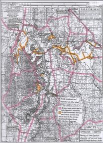
Map - Map of overlay of lake Eppalock at full capacity. Map 'C'
... The lake is a major attraction for those engaging in watersports, with a number of tourist parks and accommodation facilities available. Permissible activities on the lake include high-speed boating, water skiing, sailing, canoeing, fishing and swimming. ...The lake is a major attraction for those engaging in watersports, with a number of tourist parks and accommodation facilities available. Permissible activities on the lake include high-speed boating, water skiing, sailing, canoeing, fishing and swimming. ...John Perry collection. Map 'C'. Laminated map of overlay of Lake Eppalock at full capacity. Circa 1951. The dam was built by the State Rivers and Water Supply Commission of Victoria. The dam wall height is 45 metres (148 ft) and the main embankment is 1,041 metres (3,415 ft) long. At 100% capacity the dam wall was designed to hold back 304,651 megalitres (6.7014×10¹⁰ imp gal; 8.0480×10¹⁰ US gal) of water. The surface area of Lake Eppalock is 3,011 hectares (7,440 acres) and the catchment area is 2,124 square kilometres (820 sq mi). The controlled spillway is capable of discharging 8,040 cubic metres per second (284,000 cu ft/s). Lake Eppalock supplies both stock and domestic water to the Campaspe irrigation district. It also serves as a water supply to Bendigo and Heathcote and, in more recent times, Ballarat. The lake is a major attraction for those engaging in watersports, with a number of tourist parks and accommodation facilities available. Permissible activities on the lake include high-speed boating, water skiing, sailing, canoeing, fishing and swimming. The lake's water levels were low for approximately eight years between 2002 and 2010 during a prolonged drought, which restricted the amount of recreational activity until rainfall in the latter half of 2010 returned the lake to 100 percent capacity. Built between 1961 and 1964, Lake Eppalock remains the only water storage on the Campaspe River system.map, water, eppalock, dam, reservoir -
 Bendigo Historical Society Inc.
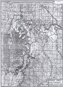
Map - Laminated map of Lake Eppalock empty. Map 'D'
... The lake is a major attraction for those engaging in watersports, with a number of tourist parks and accommodation facilities available. Permissible activities on the lake include high-speed boating, water skiing, sailing, canoeing, fishing and swimming. ...The lake is a major attraction for those engaging in watersports, with a number of tourist parks and accommodation facilities available. Permissible activities on the lake include high-speed boating, water skiing, sailing, canoeing, fishing and swimming. ...John Perry Collection. Laminated map of Lake Eppalock empty. Map 'D'. Circa 1951. The dam was built by the State Rivers and Water Supply Commission of Victoria. The dam wall height is 45 metres (148 ft) and the main embankment is 1,041 metres (3,415 ft) long. At 100% capacity the dam wall was designed to hold back 304,651 megalitres (6.7014×10¹⁰ imp gal; 8.0480×10¹⁰ US gal) of water. The surface area of Lake Eppalock is 3,011 hectares (7,440 acres) and the catchment area is 2,124 square kilometres (820 sq mi). The controlled spillway is capable of discharging 8,040 cubic metres per second (284,000 cu ft/s). Lake Eppalock supplies both stock and domestic water to the Campaspe irrigation district. It also serves as a water supply to Bendigo and Heathcote and, in more recent times, Ballarat. The lake is a major attraction for those engaging in watersports, with a number of tourist parks and accommodation facilities available. Permissible activities on the lake include high-speed boating, water skiing, sailing, canoeing, fishing and swimming. The lake's water levels were low for approximately eight years between 2002 and 2010 during a prolonged drought, which restricted the amount of recreational activity until rainfall in the latter half of 2010 returned the lake to 100 percent capacity. Built between 1961 and 1964, Lake Eppalock remains the only water storage on the Campaspe River system.map, water, dam, reservoir, eppalock -
 Bendigo Historical Society Inc.
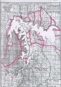
Map - Laminated map of Lake Eppalock at full capacity
... The lake is a major attraction for those engaging in watersports, with a number of tourist parks and accommodation facilities available. Permissible activities on the lake include high-speed boating, water skiing, sailing, canoeing, fishing and swimming. ...The lake is a major attraction for those engaging in watersports, with a number of tourist parks and accommodation facilities available. Permissible activities on the lake include high-speed boating, water skiing, sailing, canoeing, fishing and swimming. ...John Perry Collection. Laminated copy of map of Lake Eppalock at full capacity. Had highlighter markings of old roads which appear to be still in use. The dam was built by the State Rivers and Water Supply Commission of Victoria. The dam wall height is 45 metres (148 ft) and the main embankment is 1,041 metres (3,415 ft) long. At 100% capacity the dam wall was designed to hold back 304,651 megalitres (6.7014×10¹⁰ imp gal; 8.0480×10¹⁰ US gal) of water. The surface area of Lake Eppalock is 3,011 hectares (7,440 acres) and the catchment area is 2,124 square kilometres (820 sq mi). The controlled spillway is capable of discharging 8,040 cubic metres per second (284,000 cu ft/s). Lake Eppalock supplies both stock and domestic water to the Campaspe irrigation district. It also serves as a water supply to Bendigo and Heathcote and, in more recent times, Ballarat. The lake is a major attraction for those engaging in watersports, with a number of tourist parks and accommodation facilities available. Permissible activities on the lake include high-speed boating, water skiing, sailing, canoeing, fishing and swimming. The lake's water levels were low for approximately eight years between 2002 and 2010 during a prolonged drought, which restricted the amount of recreational activity until rainfall in the latter half of 2010 returned the lake to 100 percent capacity. Built between 1961 and 1964, Lake Eppalock remains the only water storage on the Campaspe River system.map, water, dam, reservoir, eppalock -
 Bendigo Historical Society Inc.
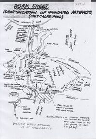
Map - Laminated worksheet - identification of inundated artifacts at Lake Eppalock
... The lake is a major attraction for those engaging in watersports, with a number of tourist parks and accommodation facilities available. Permissible activities on the lake include high-speed boating, water skiing, sailing, canoeing, fishing and swimming. ...The lake is a major attraction for those engaging in watersports, with a number of tourist parks and accommodation facilities available. Permissible activities on the lake include high-speed boating, water skiing, sailing, canoeing, fishing and swimming. ...John Perry Collection. Laminated copy of worksheet identifying inundated artifacts at Lake Eppalock when at 10% capacity. The dam was built by the State Rivers and Water Supply Commission of Victoria. The dam wall height is 45 metres (148 ft) and the main embankment is 1,041 metres (3,415 ft) long. At 100% capacity the dam wall was designed to hold back 304,651 megalitres (6.7014×10¹⁰ imp gal; 8.0480×10¹⁰ US gal) of water. The surface area of Lake Eppalock is 3,011 hectares (7,440 acres) and the catchment area is 2,124 square kilometres (820 sq mi). The controlled spillway is capable of discharging 8,040 cubic metres per second (284,000 cu ft/s). Lake Eppalock supplies both stock and domestic water to the Campaspe irrigation district. It also serves as a water supply to Bendigo and Heathcote and, in more recent times, Ballarat. The lake is a major attraction for those engaging in watersports, with a number of tourist parks and accommodation facilities available. Permissible activities on the lake include high-speed boating, water skiing, sailing, canoeing, fishing and swimming. The lake's water levels were low for approximately eight years between 2002 and 2010 during a prolonged drought, which restricted the amount of recreational activity until rainfall in the latter half of 2010 returned the lake to 100 percent capacity. Built between 1961 and 1964, Lake Eppalock remains the only water storage on the Campaspe River system.map, artifacts, eppalock, reservoir -
 Bendigo Historical Society Inc.
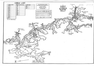
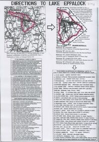
Document - Directions to Lake Eppalock with road descriptions and map
... The lake is a major attraction for those engaging in watersports, with a number of tourist parks and accommodation facilities available. Permissible activities on the lake include high-speed boating, water skiing, sailing, canoeing, fishing and swimming. ...The lake is a major attraction for those engaging in watersports, with a number of tourist parks and accommodation facilities available. Permissible activities on the lake include high-speed boating, water skiing, sailing, canoeing, fishing and swimming. ...John Perry Collection. Laminated copy of 'Directions to Lake Eppalock'. Gives directions in relationship of Lake Eppalock to Bendigo, Kyneton and Heathcote. Undated. Gives basic descriptions of bridges on lakebed, ford crossings on lakebed and inundated dwellings on lakebed. The dam was built by the State Rivers and Water Supply Commission of Victoria. The dam wall height is 45 metres (148 ft) and the main embankment is 1,041 metres (3,415 ft) long. At 100% capacity the dam wall was designed to hold back 304,651 megalitres (6.7014×10¹⁰ imp gal; 8.0480×10¹⁰ US gal) of water. The surface area of Lake Eppalock is 3,011 hectares (7,440 acres) and the catchment area is 2,124 square kilometres (820 sq mi). The controlled spillway is capable of discharging 8,040 cubic metres per second (284,000 cu ft/s). Lake Eppalock supplies both stock and domestic water to the Campaspe irrigation district. It also serves as a water supply to Bendigo and Heathcote and, in more recent times, Ballarat. The lake is a major attraction for those engaging in watersports, with a number of tourist parks and accommodation facilities available. Permissible activities on the lake include high-speed boating, water skiing, sailing, canoeing, fishing and swimming. The lake's water levels were low for approximately eight years between 2002 and 2010 during a prolonged drought, which restricted the amount of recreational activity until rainfall in the latter half of 2010 returned the lake to 100 percent capacity. Built between 1961 and 1964, Lake Eppalock remains the only water storage on the Campaspe River system.water, dam, directions, eppalock -
 Bendigo Historical Society Inc.
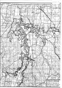
Map - Map of Lake Eppalock shoreline when empty
... The lake is a major attraction for those engaging in watersports, with a number of tourist parks and accommodation facilities available. Permissible activities on the lake include high-speed boating, water skiing, sailing, canoeing, fishing and swimming. ...The lake is a major attraction for those engaging in watersports, with a number of tourist parks and accommodation facilities available. Permissible activities on the lake include high-speed boating, water skiing, sailing, canoeing, fishing and swimming. ...John Perry Collection. Laminated copy of map detailing Lake Eppalock shoreline when empty. Circa 1951. Has colored highlighter lines following roads leading to lake shoreline and various inundated old roads and tracks on lakebed. The dam was built by the State Rivers and Water Supply Commission of Victoria. The dam wall height is 45 metres (148 ft) and the main embankment is 1,041 metres (3,415 ft) long. At 100% capacity the dam wall was designed to hold back 304,651 megalitres (6.7014×10¹⁰ imp gal; 8.0480×10¹⁰ US gal) of water. The surface area of Lake Eppalock is 3,011 hectares (7,440 acres) and the catchment area is 2,124 square kilometres (820 sq mi). The controlled spillway is capable of discharging 8,040 cubic metres per second (284,000 cu ft/s). Lake Eppalock supplies both stock and domestic water to the Campaspe irrigation district. It also serves as a water supply to Bendigo and Heathcote and, in more recent times, Ballarat. The lake is a major attraction for those engaging in watersports, with a number of tourist parks and accommodation facilities available. Permissible activities on the lake include high-speed boating, water skiing, sailing, canoeing, fishing and swimming. The lake's water levels were low for approximately eight years between 2002 and 2010 during a prolonged drought, which restricted the amount of recreational activity until rainfall in the latter half of 2010 returned the lake to 100 percent capacity. Built between 1961 and 1964, Lake Eppalock remains the only water storage on the Campaspe River system.map, eppalock, reservoir, lake, water -
 Bendigo Historical Society Inc.
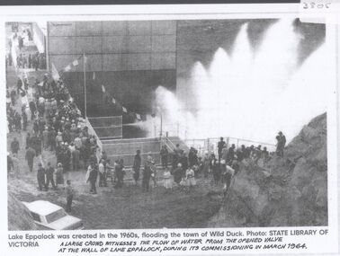
Document - Black and white laminated photo of flow of water from Lake Eppalock. 1964
... The lake is a major attraction for those engaging in watersports, with a number of tourist parks and accommodation facilities available. Permissible activities on the lake include high-speed boating, water skiing, sailing, canoeing, fishing and swimming. ...The lake is a major attraction for those engaging in watersports, with a number of tourist parks and accommodation facilities available. Permissible activities on the lake include high-speed boating, water skiing, sailing, canoeing, fishing and swimming. ...John Perry Collection. Laminated copy of photo of crowd watching flow of water from the opened valve at the wall of Lake Eppalock during its commissioning. March, 1964. Lake Eppalock was created by flooding to town of Wild Duck. The dam was built by the State Rivers and Water Supply Commission of Victoria. The dam wall height is 45 metres (148 ft) and the main embankment is 1,041 metres (3,415 ft) long. At 100% capacity the dam wall was designed to hold back 304,651 megalitres (6.7014×10¹⁰ imp gal; 8.0480×10¹⁰ US gal) of water. The surface area of Lake Eppalock is 3,011 hectares (7,440 acres) and the catchment area is 2,124 square kilometres (820 sq mi). The controlled spillway is capable of discharging 8,040 cubic metres per second (284,000 cu ft/s). Lake Eppalock supplies both stock and domestic water to the Campaspe irrigation district. It also serves as a water supply to Bendigo and Heathcote and, in more recent times, Ballarat. The lake is a major attraction for those engaging in watersports, with a number of tourist parks and accommodation facilities available. Permissible activities on the lake include high-speed boating, water skiing, sailing, canoeing, fishing and swimming. The lake's water levels were low for approximately eight years between 2002 and 2010 during a prolonged drought, which restricted the amount of recreational activity until rainfall in the latter half of 2010 returned the lake to 100 percent capacity. Built between 1961 and 1964, Lake Eppalock remains the only water storage on the Campaspe River system.water, dam, reservoir, eppalock, wild duck -
 Warrnambool and District Historical Society Inc.
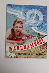
Document - Warrnambool Playground of the South Tourist Guide, Collett & Bain, 1959
... This guide gives an insight into tourist attractions and facilities in Warrnambool in the late 1950's warrnambool warrnambool tourist guide Front cover: Warrnambool Playground of the South Rear cover: A Warrnambool Holiday for Everyone This 24page paper booklet contains colour and black and white photographs and text showcasing Warrnambool as a tourist destination. ...A 1959 tourist guide showcasing Warrnambool attractions.This guide gives an insight into tourist attractions and facilities in Warrnambool in the late 1950'sThis 24page paper booklet contains colour and black and white photographs and text showcasing Warrnambool as a tourist destination. The front cover has an illustration of a young man on the sand dunes, a small map of Victoria locating Warrnambool in the bottom left hand corner and stylised tourist activities in the top right hand quadrant. The rear cover has a photograph of a woman in a swimsuit holding a green surf board surrounded by stylised tourist activities printed in red ink. There is a blue banner across the bottom of the rear cover.Front cover: Warrnambool Playground of the South Rear cover: A Warrnambool Holiday for Everyonewarrnambool, warrnambool tourist guide -
 Warrnambool and District Historical Society Inc.
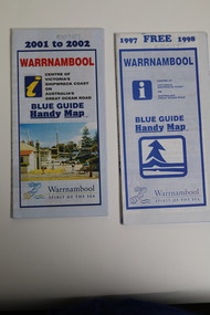
Pamphlet (Collection) - Warrnambool Tourist Maps, Warrnambool City Council, 1975 to 2002
... All have been produced for the benefit of local people and tourists, showing streets in Warrnambool, local amenities and public buildings and businesses and accommodation facilities. ...All have been produced for the benefit of local people and tourists, showing streets in Warrnambool, local amenities and public buildings and businesses and accommodation facilities. ...Warrnambool Tourist Maps collected over the years by Warrnambool Historical Society membersPreservation of local maps for historical purposesEnclosed in A4 size plastic envelopes in an A4 size archival box and numbered and catalogued according to the date of acquisition.This collection has 16 pamphlets containing maps of Warrnambool and district and some accompanying printed materialwarrnambool tourism, city of warrnambool, shipwreck coast tourismwarrnambool tourism, city of warrnambool, shipwreck coast tourism -
 Warrnambool and District Historical Society Inc.
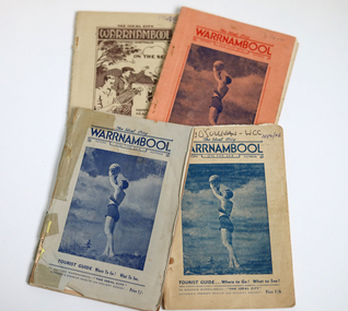
Booklet - The Ideal City Warrnambool On the Sea, 1944-1948
... Tourist Associations in Warrnambool prior to 1927 and all of them promoted Warrnambool as a health resort and an ideal holiday destination with the Sea Baths in Gilles Street and the beach close by. These guides were produced during and immediately post World War Two with rationing of petrol and other goods and most people in Victoria would not have been contemplating long and expensive holidays so Warrnambool with its rail service and beach facilities would have been seen as a possible holiday destination. ...Tourist Associations in Warrnambool prior to 1927 and all of them promoted Warrnambool as a health resort and an ideal holiday destination with the Sea Baths in Gilles Street and the beach close by. These guides were produced during and immediately post World War Two with rationing of petrol and other goods and most people in Victoria would not have been contemplating long and expensive holidays so Warrnambool with its rail service and beach facilities would have been seen as a possible holiday destination. ...These booklets were issued in 1944 to 1948 by the Warrnambool Progress and Tourist Association(established in 1927). Warrnambool was the winner of the Sun News Pictorial Quest in 1928, the ‘Ideal City’ and used this title to promote the city. There had been several Tourist Associations in Warrnambool prior to 1927 and all of them promoted Warrnambool as a health resort and an ideal holiday destination with the Sea Baths in Gilles Street and the beach close by. These guides were produced during and immediately post World War Two with rationing of petrol and other goods and most people in Victoria would not have been contemplating long and expensive holidays so Warrnambool with its rail service and beach facilities would have been seen as a possible holiday destination. The booklets contain information on the tourist attractions of Warrnambool and district, black and white photographs of buildings, events and scenic spots and advertisements for local businesses. Many of the advertisements also contain photographs of business premises.These booklets are of interest as they contain photographs of Warrnambool in the mid to late 1940's and advertisements for many business operating at that time.[.1] 56 page booklet. The apricot cover has red printing and a picture of a young woman holding a beach ball aloft on the front. The white pages have black printing & blue coloured photographs. The last page is pink. [.2] 54 page stapled booklet. The pale blue cover has dark blue printing and a picture of a young woman holding a beach ball aloft on the front. There are three pink pages at the front. The remainder are white with black printing. This booklet contains a handwritten letter to the Warrnambool City Council and a yellow page typed reply acknowledging the donation. [.3] 48 page originally stapled booklet now held together with white cotton. The beige cover has dark blue printing and a picture of a young woman holding a beach ball aloft on the front. Name written in biro on front cover. There are blue and pink pages which contain photographs and an apricot coloured fold out map. [.4] 50 page booklet with rounded corners. The beige cover has brown printing and a drawing of a tennis player and golfer waving to two ladies in bathing costumes on the beach. There are sail boats, a mountain, clouds and a gum tree in the background. There are some coloured pages. [.1] The Ideal City WARRNAMBOOL ON THE SEA Victoria Australia Tourist Guide Where to Go! What to See! To Advance Warrnambool - "THE IDEAL CITY" Victoria's Premier Health and Holiday Resort - Price 6d. [.2] The Ideal City WARRNAMBOOL ON THE SEA Victoria Australia Tourist Guide Where to Go! What to See! To Advance Warrnambool - "THE IDEAL CITY" Victoria's Premier Health and Holiday Resort - Price 1/- [.3] The Ideal City WARRNAMBOOL ON THE SEA Victoria Australia Tourist Guide Where to Go! What to See! To Advance Warrnambool - "THE IDEAL CITY" Victoria's Premier Health and Holiday Resort - Price 1/6 Handwritten in biro Terry O'Sullivan - WCC 20/2/06 [.4] The Ideal City WARRNAMBOOL Victoria Australia ON THE SEA Happy Holiday Health Resort Surfing Boating Shooting Tourist Guide Where to Go! What to See! To Advance Warrnambool - "THE IDEAL CITY" Victoria's Premier Health and Holiday Resort - Price 1/6 Handwritten in biro 1948 warrnambool, ideal city, warrnambool tourist guide, warrnambool progress and tourist association, warrnambool tourism, warrnambool business advertisements -
 Warrnambool and District Historical Society Inc.
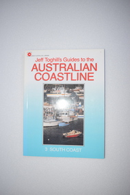
Book, Hodder & Stoughton (Australia) Pty Ltd, Australian Coast Line, 1987
... tourists. Some of the information regarding places to stay and recreational facilities etc will date over the years and the book will be of less use....tourists. Some of the information regarding places to stay and recreational facilities etc will date over the years and the book will be of less use. ...This book details the places and towns along the south coast of Australia. It contains potted histories and information for tourists. Some of the information regarding places to stay and recreational facilities etc will date over the years and the book will be of less use.This book is of minor interest as a summary of the places along the coastline of Victoria and as a useful resource book in our library.This s a soft-cover book of 128 pages. It has a blue cover with a colour photograph and red and white printing on the front cover and a colour photograph of the author and black printing on the back cover. The pages contain printed material, black and white photographs and maps and sketches. coastline of victoria, history of warrnambool -
 Warrnambool and District Historical Society Inc.
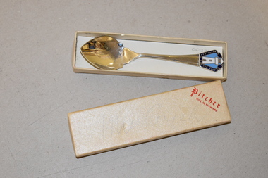
Souvenir Spoon, Pitcher Company, Warrnambool Bowling Club, 1970s
... Today the club has its facilities in Kelp Street Warrnambool and its logo features a Warrnambool lighthouse. This spoon is a memento of the Warrnambool Bowls Club and shows the type of souvenir popular with members and tourists some 40 or 50 years ago. warrnambool bowls club History of Warrnambool Spoon: Warrnambool Bowling Club Pitcher EPNS A1 Box: Pitcher Fine Silverware This is an electro-plated nickel silver jam spoon. ...This is a souvenir jam spoon which would have been given or sold to Warrnambool Bowling Club members and visitors to Warrnambool. The game of lawn bowls was first played in Warrnambool in 1868 but the present day Warrnambool Bowls Club was founded in 1890, with a bowling green in Liebig Street, Warrnambool. Today the club has its facilities in Kelp Street Warrnambool and its logo features a Warrnambool lighthouse.This spoon is a memento of the Warrnambool Bowls Club and shows the type of souvenir popular with members and tourists some 40 or 50 years ago. This is an electro-plated nickel silver jam spoon. It has a coloured metal piece welded into the top of the spoon. This has been enamelled in blue, white and silver and has an image of a lighthouse and some printing. There are also some markings on the back of the spoon. The spoon is in a cream-coloured cardboard box which is rectangular-shaped. Spoon: Warrnambool Bowling Club Pitcher EPNS A1 Box: Pitcher Fine Silverware warrnambool bowls club, history of warrnambool -
 Warrnambool and District Historical Society Inc.
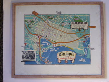
Advertising, Tourist Map of Warrnambool (framed x 2), 1950s
... ‘Warrnambool – 163 miles from Melbourne – a popular tourist resort offering many holiday attractions – an ideal surfing beach with all modern facilities is avalable’ ‘Fit Olympic Tyres, Champions of the Road’ ...Alan Lane Foundation Warrnambool tourism ‘Warrnambool – 163 miles from Melbourne – a popular tourist resort offering many holiday attractions – an ideal surfing beach with all modern facilities is avalable’ ‘Fit Olympic Tyres, Champions of the Road’ This is a tourist map of the Warrnambool C.B.D. and adjoining streets produced as an advertisement for Olympic Tyres. ...These framed tourist maps came from the Lane Foundation so it is presumed that they were from the office of Lane’s Travel Service which operated from 205 Raglan Parade Warrnambool with the known dates, the 1950s and 1960s. The proprietor, Alan Lane, was a successful Warrnambool businessman who operated a Warrnambool and district bus service as well as his travel business. He was heavily involved in local community affairs being a Warrnambool Councillor for 18 years from 1952 to 1970 and President of the Warrnambool Chamber of Commerce for six years. He was a major donor to the Warrnambool Performing Arts Centre, the Warrnambool Art Gallery and the St. John of God Hospital and left the bulk of his estate to the Alan Lane Foundation which has contributed millions of dollars to local organizations and programs. Alan Lane died in 1995. These framed maps are of some interest as examples of the tourism maps used to promote the city and district in the 1950s and 60s. This is a tourist map of the Warrnambool C.B.D. and adjoining streets produced as an advertisement for Olympic Tyres. It is multi-coloured and has cartoon sketches of the main tourist attractions and pointers to attractions outside of the main city area. It includes an inset black and white photograph of the Warrnambool Botanic Gardens and an advertisement for Olympic Tyres. It is printed on a white background and is enclosed behind glass in a wooden frame of a light brown colour. It has a wire at the back for attachment to a wall. ‘Warrnambool – 163 miles from Melbourne – a popular tourist resort offering many holiday attractions – an ideal surfing beach with all modern facilities is avalable’ ‘Fit Olympic Tyres, Champions of the Road’ alan lane foundation, warrnambool tourism -
 Warrnambool and District Historical Society Inc.
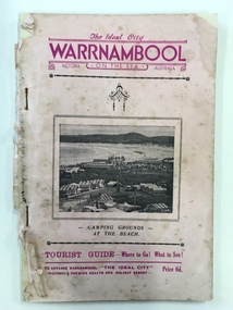
Booklet - The Ideal City Warrnambool On the Sea, Modern Print, 1940
... There had been several Tourist Associations in Warrnambool prior to 1927 and all of them promoted Warrnambool as a health resort and an ideal holiday destination with the Sea Baths in Gilles Street and the beach close by. This guide has been produced during World War Two with rationing of petrol and other goods and most people in Victoria would not have been contemplating long and expensive holidays so Warrnambool with its rail service and beach facilities would have been seen as a possible holiday destination. ...There had been several Tourist Associations in Warrnambool prior to 1927 and all of them promoted Warrnambool as a health resort and an ideal holiday destination with the Sea Baths in Gilles Street and the beach close by. This guide has been produced during World War Two with rationing of petrol and other goods and most people in Victoria would not have been contemplating long and expensive holidays so Warrnambool with its rail service and beach facilities would have been seen as a possible holiday destination. ...This booklet has been issued in 1940 by the Warrnambool Progress and Tourist Association established in 1927. Warrnambool was the winner of the Sun News Pictorial Quest in 1928, the ‘Ideal City’ and used this title to promote the city. There had been several Tourist Associations in Warrnambool prior to 1927 and all of them promoted Warrnambool as a health resort and an ideal holiday destination with the Sea Baths in Gilles Street and the beach close by. This guide has been produced during World War Two with rationing of petrol and other goods and most people in Victoria would not have been contemplating long and expensive holidays so Warrnambool with its rail service and beach facilities would have been seen as a possible holiday destination. This Warrnambool Tourist Guide is of considerable interest both for its content regarding Warrnambool’s attractions in World War Two and for its 1940s advertisements and photographs. This is a booklet of 33 pages stapled together. It is a Warrnambool Tourist Guide from the 1940s. The pages are mostly white but there are a couple of blue and buff-coloured pages. The cover is pink with mauve and black printed material and a photograph on the front cover of the Warrnambool camping ground on the foreshore. The back cover has become detached. The booklet contains information on the tourist attractions of Warrnambool and district, black and white photographs of buildings, events and scenic spots and advertisements for local businesses. Many of the advertisements also contain photographs of business premises. Front Cover: ‘The Ideal City, Warrnambool On The Sea, , Victoria, Australia, Camping Grounds at the Beach, Tourist Guide – Where to Go! What to See! To Advance Warrnambool, The Ideal City, Victoria’s Premier Health and Holiday Resort, Price 6d.’ tourism in warrnambool, warrnambool, sun news pictorial quest, warrnambool tourist guide, the ideal city -
 Kiewa Valley Historical Society
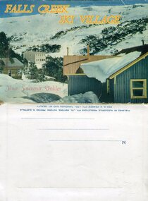
Souvenir Postcard Folder – Falls Creek Ski Village
... Falls Creek Post Office opened on 9 June 1958 (with telegraph and telephone facilities only until 1964) .Despite strong opposition from the head of the Kiewa scheme, who didn't want tourists clogging up his roads and destroying his "dry" construction camps by bringing in booze, Falls Creek boomed as much as Hotham, partly owing to its relatively good access road. ...Falls Creek Post Office opened on 9 June 1958 (with telegraph and telephone facilities only until 1964) .Despite strong opposition from the head of the Kiewa scheme, who didn't want tourists clogging up his roads and destroying his "dry" construction camps by bringing in booze, Falls Creek boomed as much as Hotham, partly owing to its relatively good access road. ...After World War II, the Kiewa Hydroelectric Scheme was started in the Kiewa River valley by the State Electricity Commission of Victoria. On land previously used only for summer cattle grazing in the natural alpine grasslands, the first ski lodge was built in 1948 by workers from the scheme. The first lift, a rope tow, was built in 1951 and the first chairlift in Australia was constructed there in 1957. Falls Creek Post Office opened on 9 June 1958 (with telegraph and telephone facilities only until 1964) .Despite strong opposition from the head of the Kiewa scheme, who didn't want tourists clogging up his roads and destroying his "dry" construction camps by bringing in booze, Falls Creek boomed as much as Hotham, partly owing to its relatively good access road. Early lodges included Bogong (c.1946), Skyline (1947), Albury (1949), Myrtleford (1949) and Dawn (c.1950).The souvenir postcard photographed and produced by an enterprising local businessman Mr S K Pearce, was produced as a memento for skiers and other visitors to the Falls Creek and Mt Beauty area to send to family and friends as a reminder of their visit to the region, or to keep as a personal souvenir. It presented an excellent promotional opportunity for enterprising local businessmen to promote the area to skiers and tourists near and far. It also presents an excellent pictorial history of the falls creek area around the late 1950’s to early 1960’sColour postcard folder (unused) containing 13 photographs of the Falls Creek ski area and surrounds. Inside cover has a brief description of the area and the services available to visitors Printed on front cover- FALLS CREEK SKI VILLAGE. Your Souvenir Folder Photo of skiing slopes of the village Inside front flap - a brief description of the Falls Creek area and the services available to visitors 1. Diana Lodge parking area and Spion Kopje 2. Winterhaven Lodge 3. Ski Hirage Centre and skiing slopes 4. Ski Lodges from main road 5. Nelse and Arundel Lodges 6. Day visitors’ shelter and parking area 7. Summit T-Bar lift 8. Spur T-bar looking towards Village and Spion Kopje 9. T-bar lower station and Snow Crystal Inn 10. ‘Akja’ rescue sled in use 11. Falls Creek road and Grand Coeur Lodge annex 12. Rope tows and beginner slopes 13. Back cover- Published by Nucolorvue Pty Ltd Mentone Vic. Printed in Australia For S.K.Pearce Pty Ltd Tawonga and Mt Beauty falls creek, snow, bogong high plains, victorian alps -
 Kiewa Valley Historical Society
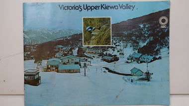
Booklet - SEC x2, 1. Victoria's Kiewa Valley 2. Victoria's Upper Kiewa Valley, No. 2 is dated October 1978
... The booklet includes Facilities, Falls Creek Ski Resort, the Kiewa Works Area, the Three Floras of Bogong, the Geology of the Kiewa area, the Bird and Animal life of Bogong and the Kiewa Hydro Electric Scheme. The colored photos and the map on the back appeal to the reader/tourist...The booklet includes Facilities, Falls Creek Ski Resort, the Kiewa Works Area, the Three Floras of Bogong, the Geology of the Kiewa area, the Bird and Animal life of Bogong and the Kiewa Hydro Electric Scheme. The colored photos and the map on the back appeal to the reader/tourist ...The State Electricity Commission of Victoria built the Kiewa Hydro Electric Scheme and was keen to promote tourism in the area. The booklet includes Facilities, Falls Creek Ski Resort, the Kiewa Works Area, the Three Floras of Bogong, the Geology of the Kiewa area, the Bird and Animal life of Bogong and the Kiewa Hydro Electric Scheme. The colored photos and the map on the back appeal to the reader/tourist.The SECV promoted tourism in the Kiewa Valley especially the area of the Kiewa Hydro Electric Scheme. This booklet is attractive and informative with a lot of detail. This proved to be the early stages of tourism in the area in what is now a very popular tourist destination and the main industry for the Upper Kiewa Valley.Blue cover with photo of Falls Creek at night. Title in black print at the centre top under which is an insert photo of a blue wren and SEC logo in white towards the top far right. Back cover is light green with a tourist map of the area. The text is complimented with brightly colored photos throughout.state electricity commission of victoria; kiewa hydro electric scheme; tourism; bogong; flora; fauna; geology; -
 Kiewa Valley Historical Society
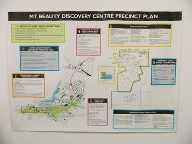
Poster - Mt Beauty Discovery Centre Precinct Plan
... Kiewa Valley Historical Society Mount Beauty Information Centre 31 Bogong High Plains Rd Mt Beauty high-country The current (2015) Mt Beauty Tourist Centre site was to be upgraded into a 'Sports Tourism Cluster' with funding from the Government and the Alpine Shire with 'In Kind' assistance from Falls Creek Resort management Board, Parks Victoria and the Local Community & Tourism Industry. This project didn't go ahead. The Mt Beauty town was handed over to the Alpine Shire in the 1960's after completion of the Kiewa Hydro Electric Scheme. Plans for up dating facilities ...The current (2015) Mt Beauty Tourist Centre site was to be upgraded into a 'Sports Tourism Cluster' with funding from the Government and the Alpine Shire with 'In Kind' assistance from Falls Creek Resort management Board, Parks Victoria and the Local Community & Tourism Industry. This project didn't go ahead.The Mt Beauty town was handed over to the Alpine Shire in the 1960's after completion of the Kiewa Hydro Electric Scheme. Plans for up dating facilities are on-going but are rarely completed. This poster is an example of this.Very large laminated poster depicting 6 points for the Alpine Region Sports Tourism Cluster. Each point has a coloured border and background to black writing. There are 3 maps.mt beauty. tourism. discovery centre. sports cluster. -
 Kiewa Valley Historical Society
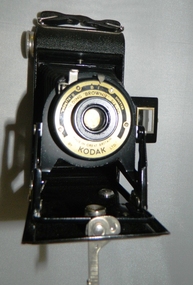
Camera Box Brownie Folding, Six 20 Folding Brownie KodetteII, Circa 1948 to late 1970s
... tourists but also retirees. The social implications of this trend will continue to provide a broader requirement for medical and other facilities geared up to the requirements of an aging population. ...This camera was made for the mobile photographer and the camera manufacturer Kodak was at the peak of production. Mr. George Eastman, the company's founder, who invented roll film, which could withstand the outdoor activities and therefor replaced photographic plates. In 1900, the Box Brownie camera was first released Kodak's motto was' "You push the button, we do the rest," The film used in this camera was Kodak Verichrome 620 introduced in 1936 and only went out of production 2009. This camera was a vintage 1970s one. Between 1963 and 1970 the company sold 50 million of this type of camera. The production of smaller and more user friendly digital cameras, mainly from Japan finally nailed the coffin lid on the Kodak Company. Ironically, one of Kodak's engineers called Steve Sasson, devised a camera that could save images using electronic circuits. The images were transferred onto a tape cassette and were viewable by attaching the camera to a TV screen, however Kodak tried to maintain its photographic film products beyond its "use by date". In1975 Kodak becomes the first company to make a digital camera, however the Japanese manufacturers could make smaller and more compact cameras ending Kodak's monopoly and eventual demise.This particular "box brownie" was used by Margaret Shefford, nee Turner, who with her husband retired, in the 1980s, to Mount Beauty. The camera was purchased in the 197's and used on their cruise to England. The significance of this item is that at the time of its introduction to Mount Beauty the camera was a "state of the art", for general public, camera introduced by an ever increasing influx of retirees. This identifies the Kiewa Valley not only as an attraction for sightseers and overseas tourists but also retirees. The social implications of this trend will continue to provide a broader requirement for medical and other facilities geared up to the requirements of an aging population. As a lot of cities in Australia have increasing levels of violence (mainly drug related) rural "retreats" are becoming more sought after by sections of "the gentle populous"This is a black metal rectangular camera, rounded on the ends and has silver colored fittings(stainless steel) and a small leather handle on hinges the left side (facing the lens). The folding lens and shutter component fold out from the main compartment. Two metal arms swing out and hold the lens and collapsible lens body to the required length. When not in use this collapsible (folding) lens extension is fastened to the main body structure providing security and preventing damage to the folding material. The camera has a collapsible eye piece or view finder at the top end. The right hand bottom end has a cylindrical film wider (polished steel). Inside there are two cylindrical cavities, one holding the roll of unexposed film and the other (winder) end a cylinder onto which the unexposed film is wound through for each picture frame. There is a locking mechanism to hold the folding lens structure to the main box structure. See KVHS 0419B for its carrying caseNo external makings but when the lens is folded out it exposes manufacturing information on metal base around the lens " Kodette II B I shutter"(B= Bulb and I= Instant), underneath this, in larger print, is "'FOLDING 'BROWNIE' SIX - 20" below the lens and in smaller print, "made in Great Britain" and underneath this "by KODAK ltd"kodak kodette ii, folding brownie camera, photography, hobby personal item, tourist gadgets. -
Kiewa Valley Historical Society
Camera Case for Box Brownie, Circa mid to late 1900s
... It is significant to this region because it underlines the slow transition from a purely farming, grazing, mining and tourist region to an area opening up to a specific socio-economical structure for retirees. This social and demographic shift by retirees will produce a greater need for changes in facilities required by an increasing aged population. ...When this leather case was made it was the only material available that not only looked fashionable but also was able to absorb any small knocks or scratches which may happen to the mobile but still delicate camera. Digitalisation of photographic equipment for non professional use brought with it a reduction in camera size (pocket), increased portability and the dispensing of thick leather cases. With the increase of camera functions on mobile telephones, the need by tourists and the general public for a dedicated camera is rapidly diminishing. The protective leather wrapping for expensive, professional goods, especially electronics is very rare and foam padded aluminium bags and containers are the preferred mode for travel.This particular leather case has travelled to and from England via an ocean cruise by a now retired couple living in the Kiewa Valley. It is significant to this region because it underlines the slow transition from a purely farming, grazing, mining and tourist region to an area opening up to a specific socio-economical structure for retirees. This social and demographic shift by retirees will produce a greater need for changes in facilities required by an increasing aged population. Though it may take more time for cities and larger towns to come to grips with a growing aged population, rural areas(because these will define more clearly any imbalance of population) present the first demonstrative change to Australia, and world wide, a population based phenomenon.This item is a brown coloured leather camera case (Box Brownie Six-20) with an adjustable strap and associated buckle. The leather has been moulded to the shape of the camera and is slightly tapered as a closing flap fastened at the front with a lockable clasp. The end of the leather flap has a metal(tin) with a semi circular ring formed to allow it to be held as part of the clasp. Pressed into the underbelly of the semicircular closing mechanism is"PAT. APPLIED FOR" and underneath this"MADE IN ENGLAND" camera, case photography, hobby, personal equipment -
 Kiewa Valley Historical Society
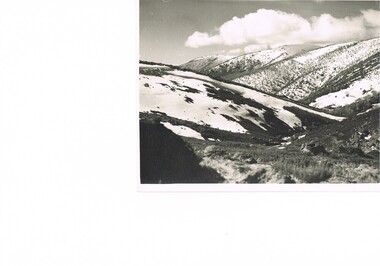
Photograph of Snow Covered Catchment Area Vic, Snow Covered Catchment Area Victorian Alps - 1950s, Circa 1950
... tourists. The mountain ranges had provided an adequate barrier against the way-would traveller, but with the opening up of this region by the provision of improved roadways and accommodation facilities, courtesy of the Kiewa Valley Hydro Electricity Scheme, changes such as tourism and its impact upon the "natural" state started to show its side effects (clearing of the land). ...tourists. The mountain ranges had provided an adequate barrier against the way-would traveller, but with the opening up of this region by the provision of improved roadways and accommodation facilities, courtesy of the Kiewa Valley Hydro Electricity Scheme, changes such as tourism and its impact upon the "natural" state started to show its side effects (clearing of the land). ...This photograph details (early to mid1950s), the Victorian Alpine region when this remote area was part of a "lay back" rural landscape,occasionally visited by recreational adventurers and some wayward tourists. The mountain ranges had provided an adequate barrier against the way-would traveller, but with the opening up of this region by the provision of improved roadways and accommodation facilities, courtesy of the Kiewa Valley Hydro Electricity Scheme, changes such as tourism and its impact upon the "natural" state started to show its side effects (clearing of the land). The expansion of the European immigration numbers (1950s) coming into Australia was increasing after World War II which not only provided increased construction workers to the region but also immigrants who appreciated alpine regions. Some of these immigrants contributed to the expansion of the region and provided for a greater degree of diverse professions and rural related work force.This photograph depicts the borderline in time between an exclusively rural based population and respective activities(early 1900s)to the present (2000 on wards) integrated village, tourist and retiree/holiday area. The time when land was exclusively used in agriculture and Alpine grazing lands is over. The Kiewa Valley is loosing its hiding place and is becoming more and more a source of untapped residential land and winter time recreational adventure lands. The changes brought about by modern technologies involving recreational activities such as hang gliding, gliding (local airstrip), mountain bikes, car rallies and their associated clubs is providing for an increased short term population boost. These together with the attractions for retirees is changing not only the physical nature of the Kiewa valley but also its "soul".This item is a black and white photograph of a section of snow covered catchment area in the Victorian Alps in the mid 1900. It is on 200 gms paper but not on photographic paper and has a white boarder (3 mm).kiewa valley tourism, victorian alps, alternate energy supplies, alpine population growth