Showing 183 items matching "township - hotels"
-
 Lakes Entrance Historical Society
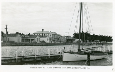
Postcard - Cunninghame Arm, Lakes Entrance 1965, Murray Views
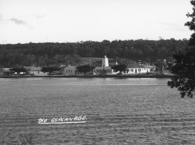
... ...Township...Hotels...Waterfront Jetties Township Hotels Entrance from Jetty, Lakes Entrance, Victoria Black and white postcard taken from a jetty on Cunninghame Arm, Lakes Entrance, showing Esplanade from Bellevue Guest House to Prince Regent Theatre and six of the World War 1 memorial cypress trees. ...Black and white postcard taken from a jetty on Cunninghame Arm, Lakes Entrance, showing Esplanade from Bellevue Guest House to Prince Regent Theatre and six of the World War 1 memorial cypress trees. Yacht at jetty in foreground. Lakes Entrance VictoriaEntrance from Jetty, Lakes Entrance, Victoriawaterfront, jetties, township, hotels -
 Clunes Museum
Photograph, BLACK PHOTO
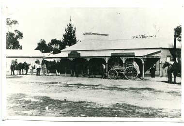
... hotel ....township - hotels...Clunes Museum 36 Fraser Street enter building through Collins Place Clunes goldfields local history photography photographs shops symons ironmongers store seven stars hotel shamrock hotel luckraft hotel commercial hotel . township - hotels PHOTOGRAPH OF LOWER END FRASER STREET CLUNES LOOKING EAST, HORSE AND DRAY IN STREET. ...PHOTOGRAPH OF LOWER END FRASER STREET CLUNES LOOKING EAST, HORSE AND DRAY IN STREET. PHOTOGRAPH SHOWS BUTCHER SHOP, SEVEN STARS HOTEL, DOWNES RESIDENCE WAS SHAMROCK HOTEL SYMONS IRONMONGERS STORE TIMBER YARD. [LUCKRAFT HOTEL, COMMERCIAL HOTEL] TAKEN ABOUT 1899 .1 BLACK AND WHITE PHOTO PRINT .2 ENLARGED PHOTO PRINT .3 SEPIA PHOTOGRAPH MOUNTED ON MATT BOARD WITH LOCATION WRITTEN AROUND PHOTOlocal history, photography, photographs, shops, symons ironmongers store, seven stars hotel, shamrock hotel, luckraft hotel, commercial hotel ., township - hotels -
 Lakes Entrance Historical Society
Postcard - Lakes Entrance 1945, 1945c
... Township... Hotels...Lakes Entrance Historical Society 4 Marine Parade Lakes Entrance gippsland North Arm Bridge and Town Township Hotels Bridges Colour photograph of bridge across North Arm, showing town and Club Hotel; jetties in Cunninghame Arm; sand dunes; and concrete brick toilet block built beside Highway between Club Hotel and North Arm. ...North Arm Bridge and TownColour photograph of bridge across North Arm, showing town and Club Hotel; jetties in Cunninghame Arm; sand dunes; and concrete brick toilet block built beside Highway between Club Hotel and North Arm. Concrete brick toilet block opposite road to Bullock Island built after World War 2 bricks made on Kimmels Farm, toilet at Harbecks Wharf and cricket club pavilion built same era. Lakes Entrance Victoriatownship, hotels, bridges -
Lakes Entrance Historical Society
Book, Britton, Tanya, Star Hotel Bruthen 1879-1968, 2004
... Township... Hotels...Lakes Entrance Historical Society 4 Marine Parade Lakes Entrance gippsland Township Hotels Land Settlement Research, interpretation and management recommendations for the Star Hotel, Bruthen, by a Forestec student. ...Research, interpretation and management recommendations for the Star Hotel, Bruthen, by a Forestec student.township, hotels, land settlement -
 Lakes Entrance Historical Society
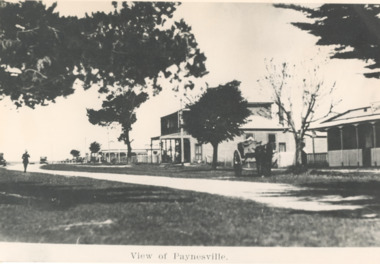
Photograph - View of Paynesville, hotel, the Esplanade Paynesville Victoria, 1910 c
... Township...Hotels...Lakes Entrance Historical Society 4 Marine Parade Lakes Entrance gippsland copied from a postcard Township Hotels Roads and Streets View of Paynesville Black and white photograph showing the hotel on the corner of the Esplanade Paynesville Victoria hotel, the Esplanade Paynesville Victoria Photograph View of Paynesville ...copied from a postcardBlack and white photograph showing the hotel on the corner of the Esplanade Paynesville VictoriaView of Paynesvilletownship, hotels, roads and streets -
 Bendigo Historical Society Inc.
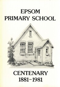
Book - EPSOM PRIMARY SCHOOL CENTENARY 1881-1981, 1981
... education primary school centenary Epsom history scholars teachers Mothers' Club Honor Roll 1914-1918 War township Epsom Salts... Hotels...History House 11 Mackenzie Street Bendigo goldfields SCHOOL Centenary epsom education primary school centenary Epsom history scholars teachers Mothers' Club Honor Roll 1914-1918 War township Epsom Salts Hotels Progress Association WW1 WW2 vineyards palm trees store Ascot park local families businesses sports Epsom Primary School Centenary 1881-1981. ...Epsom Primary School Centenary 1881-1981. Photographs, illustrations and map. 80 pages. With Indexschool, centenary, epsom, education primary school centenary epsom history scholars teachers mothers' club honor roll 1914-1918 war township epsom salts, hotels, progress association, ww1, ww2, vineyards, palm trees, store, ascot park, local families, businesses, sports -
 Lakes Entrance Historical Society
Photograph - View from Central Hotel Tower, Redman, George, 1950c
... Hotels... Township...Lakes Entrance Historical Society 4 Marine Parade Lakes Entrance gippsland Hotels Township Vehicles Black and white photograph, taken from spotting tower showing Central Hotel, with advertising sign for Buchan Caves, parked cars of the era. ...Black and white photograph, taken from spotting tower showing Central Hotel, with advertising sign for Buchan Caves, parked cars of the era. Lakes Entrance Victoriahotels, township, vehicles -
 Lakes Entrance Historical Society
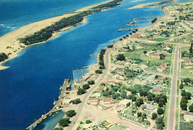
Photograph - Lakes Entrance, 1960c
... Hotels...Township...Lakes Entrance Historical Society 4 Marine Parade Lakes Entrance gippsland Copied from postcard Hotels Township Waterways Colour photograph aerial view of the township, shows also Cunninghame Arm, the hummocks and distant view of Bullock Island and the entrance. ...Copied from postcardColour photograph aerial view of the township, shows also Cunninghame Arm, the hummocks and distant view of Bullock Island and the entrance. Lakes Entrance Victoria hotels, township, waterways -
 Lakes Entrance Historical Society
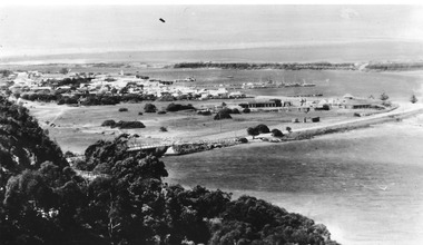
Postcard, Bulmer H D, North Arm concrete bridge, Lakes Entrance Victoria c1950, 1950c
... Township... Jetties... Islands... Hotels...Lakes Entrance Historical Society 4 Marine Parade Lakes Entrance gippsland Township of Lakes Entrance Township Jetties Islands Hotels Black and white photograph of view from Kalimna Heights, showing part of the North Arm concrete bridge, Bullock Island and western side of entrance. ...Township of Lakes Entrance Black and white photograph of view from Kalimna Heights, showing part of the North Arm concrete bridge, Bullock Island and western side of entrance. Truck parked on approach to bridge. Lakes Entrance Victoriatownship, jetties, islands, hotels -
 Lakes Entrance Historical Society
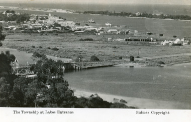
Postcard - Lakes Entrance, Bulmer H D, 1935
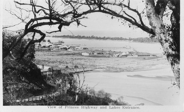
... Township... Waterways... Bridges... Hotels...Very little vegetation on Eastern end of hummocks. Township Waterways Bridges Hotels The Township at Lakes Entrance Black and white postcard of the western end of Lakes Entrance,showing a glimpse of the North Arm bridge, town situated adjacent to Cunninghame Arm, sand hummocks and ocean in distance. ...Marine Parade has not yet been formed through the low lying marshy area adjacent to North Arm. Very little vegetation on Eastern end of hummocks.Black and white postcard of the western end of Lakes Entrance,showing a glimpse of the North Arm bridge, town situated adjacent to Cunninghame Arm, sand hummocks and ocean in distance. Lakes Entrance VictoriaThe Township at Lakes Entrancetownship, waterways, bridges, hotels -
 Lakes Entrance Historical Society
Photograph - Port Albert Hotel, 1985 c
... Hotels...Township...Lakes Entrance Historical Society 4 Marine Parade Lakes Entrance gippsland Hotels Township Colour photo of the hotel at Port Albert, showing a neat weatherboard building with verandah and balcony on upper storey, close to water edge. ...Colour photo of the hotel at Port Albert, showing a neat weatherboard building with verandah and balcony on upper storey, close to water edge. Port Albert Victoriahotels, township -
 Lakes Entrance Historical Society
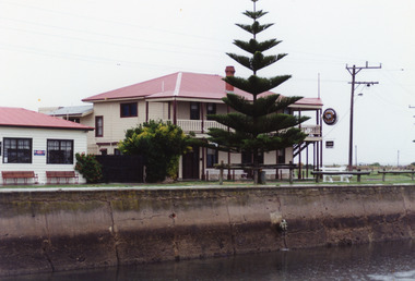
Postcard - Central Hotel Lakes Entrance, 1950c
... Hotels... Township...Hotels Township Waterfront Black and white photograph of the Esplanade, showing Cunninghame Arm in foreground, forrested slope of Kalimna escarpment in background, Central Hotel with tower positioned on corner of the Esplanade and Mechanics Street. ...Black and white photograph of the Esplanade, showing Cunninghame Arm in foreground, forrested slope of Kalimna escarpment in background, Central Hotel with tower positioned on corner of the Esplanade and Mechanics Street. Cars of the era parked in front of hotel. Lakes Entrance Victoriahotels, township, waterfront -
Clunes Museum
Map, DEPARTMENT OF LANDS AND SURVEY, TOWNSHIP OF CLUNES, PARISH OF CLUNES, COUNTY OF TALBOT, 1950
... TOWNSHIP OF CLUNES 1950...HOTELS...MAP OF CLUNES ON PAPER SHOWING HOTELS AND TOWNSHIP HIGHLIGHTS COMPLETE WITH LEGEND. ...Clunes Museum 36 Fraser Street enter building through Collins Place Clunes goldfields TOWNSHIP OF CLUNES 1950 HOTELS OF CLUNES PRICE 2s MAP OF CLUNES ON PAPER SHOWING HOTELS AND TOWNSHIP HIGHLIGHTS COMPLETE WITH LEGEND. ...MAP OF CLUNES ON PAPER SHOWING HOTELS AND TOWNSHIP HIGHLIGHTS COMPLETE WITH LEGEND. OVERWRITTEN NOTATIONS IN RED AND BLUE INKPRICE 2stownship of clunes 1950, hotels of clunes -
 Lakes Entrance Historical Society
Postcard - View from Jemmys Point, c1920
... Black and white miniature photographic postcard showing the North Arm Bridge prior 1937; post and rail fence around Kalimna road; township, Club Hotel and stables; jetties in Cunninghame Arm, Methodist Church; and sand hummocks. ...Also 1x Miniature postcard 6cmx8.5cm ' A Glimpse of Lakes Entrance' 01153-4 Bridges Hotels Fences Public Utilities Black and white miniature photographic postcard showing the North Arm Bridge prior 1937; post and rail fence around Kalimna road; township, Club Hotel and stables; jetties in Cunninghame Arm, Methodist Church; and sand hummocks. ...Also 1x Miniature postcard 6cmx8.5cm ' A Glimpse of Lakes Entrance' 01153-4Black and white miniature photographic postcard showing the North Arm Bridge prior 1937; post and rail fence around Kalimna road; township, Club Hotel and stables; jetties in Cunninghame Arm, Methodist Church; and sand hummocks. Telegraph line around hill and across sand flat. Lakes Entrance Victoriabridges, hotels, fences, public utilities -
 Orbost & District Historical Society
black and white photograph, early 20th century
... Laura Dixon held the hotel licence from 04/04/10 until 05/02/17 and during that time it was known as Dickson's Hotel. A township, known as Cunninghame after a pioneer Gippsland squatter, was surveyed near Lake Bunga in 1866. ...Laura Dixon held the hotel licence from 04/04/10 until 05/02/17 and during that time it was known as Dickson's Hotel. A township, known as Cunninghame after a pioneer Gippsland squatter, was surveyed near Lake Bunga in 1866. ...This photograph shows the Orbost - Cunninghame coach leaving from outside Dickson's Hotel in Nicholson Street Orbost. Although noted as the Dickson Hotel, this may have been the Commonwealth Hotel which opened on New Year's Day 1902. Mr Jasper Drew held the first licence. Laura Dixon held the hotel licence from 04/04/10 until 05/02/17 and during that time it was known as Dickson's Hotel. A township, known as Cunninghame after a pioneer Gippsland squatter, was surveyed near Lake Bunga in 1866. The name changed to Lakes Entrance in 1915.This is a pictorial record of horse-drawn transport commonly used in Orbost, early 19th century. It also shows the Commonwealth Hotel before the second storey was added.A black / white photograph of a large single-storey building with a horse drawn coach and seneral people and horses standing nearby. The road is unsealed. On the side of the carriage is "CUNNINGHAME".transport-horse-drawn dickson's-hotel commonwealth-hotel cunninghame -
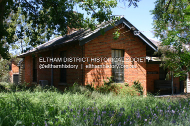
 Eltham District Historical Society Inc
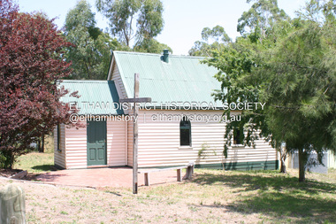
Photograph - Digital Photograph, Alan King, Panton Hill Hotel, 27 March 2008
... Today’s Panton Hill Hotel, built around 1920, is the only one of the cluster of buildings in the main road, not to date from around the turn of last century. It was severely damaged by fire in 2003, then underwent extensive alterations. It is the township’s...Today’s Panton Hill Hotel, built around 1920, is the only one of the cluster of buildings in the main road, not to date from around the turn of last century. It was severely damaged by fire in 2003, then underwent extensive alterations. It is the township’s ...Today’s Panton Hill Hotel was built around 1920. Published: Nillumbik Now and Then / Marguerite Marshall 2008; photographs Alan King with Marguerite Marshall.; p61 Panton Hill was originally known as Kingstown, and consisted of only one hotel when the Orams Reef was discovered in 1859. Kingstown was a quartz mining centre and many old mine shafts remain in the area. Orams Reef was one of the first reefs with a rich find of gold in the area. The Hotel Francais, which had been operating in 1861, was well situated on the way to Queenstown (later St Andrews). So was Herr Hirt’s Hotel and store at Smiths Gully. The Kingstown hotel, known as the Frenchman’s and in 1864 as the Hotel de France, was run by a Monsieur Emile Hude and his wife Jeanne, and known for its good food. They hosted social events, business conventions and debates, attracting patrons from as far as Melbourne. The hotel’s name was changed to Panton Hill Hotel in 1905. In 1883 Charles Caudwell built another hotel nearby, possibly in Long Gully Road,3 which it is thought, was burnt down early last century. Today’s Panton Hill Hotel, built around 1920, is the only one of the cluster of buildings in the main road, not to date from around the turn of last century. It was severely damaged by fire in 2003, then underwent extensive alterations. It is the township’s only hotel and is an example of a modest hotel building exterior, constructed early last century. In its early days the hotel also housed the first post office, newsagency and store. Orams Reef yielded a total of £100,000, and fossikers also found alluvial gold in the creeks and gullies, but there is no record of the total value of their finds. Gold greatly increased the Panton Hill population, which peaked between 1865 and 1885. On holidays large sports meetings were held with wood chopping contests and foot races and the day would end with a ball. Miners came from various countries to seek their fortune, including many from China. The Chinese became unpopular however, and gradually left the district, although some stayed and grew and sold vegetables.5 Panton Hill was named after Joseph Panton, who in 1862 was appointed Police Magistrate for the Woods Point, Heidelberg and Yarra districts. Panton was an outstanding man, who in 1852, was Commissioner of Crown Lands and Assistant Commissioner of Goldfields at Bendigo. In 1874 he was promoted to Chief Magistrate for the Melbourne Police. Panton was also an artist, becoming president of the Victorian Arts Society in 1888, and in 1913, president of the Royal Geographical Society. Despite Panton Hill’s prosperity, it still lacked many services as poor roads made access to Melbourne difficult. A horse-drawn mail coach travelled to Melbourne until 1890, when the railway came to Heidelberg. The nearest doctor was at Yarra Glen or Heidelberg, and the Indian hawker Singh’s annual visit was very welcome. A miner’s shack opposite the school was used as a post office. Today’s general store and post office in the main road dates from early last century, and has changed considerably. While most people searched for gold, the more enterprising ones established farms to feed the diggers. Farmers grew wheat, barley and oats, and sent animal skins to the Eltham tannery, to make furs in Melbourne. As gold became scarce from around 1880, miners took up farming on 19 to 20 acre (8ha) allotments. The first settlers in Cherry Tree Road included Purcell, Smith, Owens, Hughes and Shillinglaw. By 1900 all the land had been taken up around Panton Hill and Hurstbridge. The orchards in Panton Hill and the wider district, particularly of apple and pear, were very successful, and made Panton Hill a cohesive and successful community. About 1914 the Moores built the first cool-store and refrigeration plant at their orchard in Cherry Tree Road. Many settlers planted vineyards and made high quality wine, but in 1922 the blight destroyed them.This collection of almost 130 photos about places and people within the Shire of Nillumbik, an urban and rural municipality in Melbourne's north, contributes to an understanding of the history of the Shire. Published in 2008 immediately prior to the Black Saturday bushfires of February 7, 2009, it documents sites that were impacted, and in some cases destroyed by the fires. It includes photographs taken especially for the publication, creating a unique time capsule representing the Shire in the early 21st century. It remains the most recent comprehenesive publication devoted to the Shire's history connecting local residents to the past. nillumbik now and then (marshall-king) collection, panton hill hotel -
 Warrnambool and District Historical Society Inc.
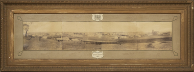
Photograph - Framed photograph of Warrnambool 1887, Town Panorama. Warrnambool Queen's Jubilee 1887, 1887
... township taken in 1887 to commemorate the Jubilee of the reign of Queen Victoria (1837-1887). The photograph is taken from Booval Hill (Liebig Street north) and shows the fencing in that area with groups of people in the foreground posing for the photograph. The panorama covers Liebig Street and Raglan Parade and includes private houses, a windmill and three tanks, St. John's Church, St. Joseph's Church, Tattersalls Hotel...township taken in 1887 to commemorate the Jubilee of the reign of Queen Victoria (1837-1887). The photograph is taken from Booval Hill (Liebig Street north) and shows the fencing in that area with groups of people in the foreground posing for the photograph. The panorama covers Liebig Street and Raglan Parade and includes private houses, a windmill and three tanks, St. John's Church, St. Joseph's Church, Tattersalls Hotel ...This is a framed photograph of a panoramic section of the Warrnambool township taken in 1887 to commemorate the Jubilee of the reign of Queen Victoria (1837-1887). The photograph is taken from Booval Hill (Liebig Street north) and shows the fencing in that area with groups of people in the foreground posing for the photograph. The panorama covers Liebig Street and Raglan Parade and includes private houses, a windmill and three tanks, St. John's Church, St. Joseph's Church, Tattersalls Hotel and the Saleyards.This photograph provides us with historical information on a section of the Warrnambool township in 1887 and is a valuable resource for researchers.This is a black and white photograph in a brown wooden frame and enclosed in glass. The photograph has a gilt metal edging outlined with ornate kite-shaped pieces on the corners and depicts a section of a town from an elevated position. At the top of the photograph is a crest in a shield shape and at the bottom is another shield shape containing the title of the photograph. The left centre section of the photograph is splotched or water-stained.Warrnambool Queen's Jubilee 1887warrnambool 1887, queen victoria's jubilee -
 Kiewa Valley Historical Society
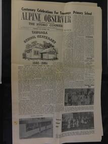
Alpine Observer Newspaper - 23 Oct. 1980 x2, 23 Oct. 1980
... (The paper consists of 12 pages ie. 6 sheets) 2 copies On page 4 is an article on the history of the Bogong Hotel at Tawonga On page 5 is an article on the history of the Tawonga Butter Factory and an article on the township of Mt Beauty....(The paper consists of 12 pages ie. 6 sheets) 2 copies On page 4 is an article on the history of the Bogong Hotel at Tawonga On page 5 is an article on the history of the Tawonga Butter Factory and an article on the township of Mt Beauty. ...The Tawonga Primary School celebrated its centenary with a program including a fete, sports, family dance and combined church service over the weekend of the 25th - 26th Oct. 1980. The newspaper covers the Alpine Shire and included further articles that would interest visitors to the centenary.Tawonga School was one of the earliest schools in the Kiewa Valley supplying an education for the children of the local farming community. The Bogong Hotel at Tawonga, the Tawonga Butter Factory and the town of Mt Beauty articles were printed providing up to date historical information on prime locations nearby. Of interest as the Hotel has burnt down and the Butter factory no longer exists. Alpine Observer newspaper dated Thursday, 23 rd October 1980 with a sketch of the school and articles regarding the Centenary of the Tawonga School on the front page. (The paper consists of 12 pages ie. 6 sheets) 2 copies On page 4 is an article on the history of the Bogong Hotel at Tawonga On page 5 is an article on the history of the Tawonga Butter Factory and an article on the township of Mt Beauty.newspaper articles; tawonga primary school; bogong hotel; tawonga butter factory -
 Kiewa Valley Historical Society
Photo Framed - Tawonga South, c1940's
... township was built as the occupier was working on the Kiewa Hydro Electric Scheme. The Barters came to work on the State Electricity Commission of Victoria's Kiewa Hydro Electric Scheme before housing in the town of Mt Beauty was built. The Barters rudimentary dwelling was probably not a legal building. The photo was taken by Vera Hore (nee Ryder), the publican at the Bogong Hotel ...Tawonga South was situated between the rural township of Tawonga and the State Electricity Commission of Victoria's construction town of Mt Beauty. The building in the fore ground of the photo was built before the Mt Beauty township was built as the occupier was working on the Kiewa Hydro Electric Scheme.The Barters came to work on the State Electricity Commission of Victoria's Kiewa Hydro Electric Scheme before housing in the town of Mt Beauty was built. The Barters rudimentary dwelling was probably not a legal building. The photo was taken by Vera Hore (nee Ryder), the publican at the Bogong Hotel near Tawonga South where the photo was taken. Vera, 1909 - 2000, was a keen amateur photographer.Colored photo of Tawonga South with a dwelling in the bottom of the right hand corner and Mt Bogong, covered in snow, at the top. Framed with cream card board 1 cm wide and a metal decorated frame surrounding it.On the back - "Vera Hore"tawonga south; vera hore; mt beauty -
 Streatham and District Historical Society
Picture, Streatham Hotel
... The building opperated as the local hotel until 1977" when a fire burnt through the township of Streatham. ...The building opperated as the local hotel until 1977" when a fire burnt through the township of Streatham. ...There is a man leaning on a bike against the bluestone wall of a building. There are several windows and doors to the establishment. The building opperated as the local hotel until 1977" when a fire burnt through the township of Streatham. The front of the building was distroyed and a smaller hotel operated after the fire. Shows the kind of early buildings in the township of Streatham.Rectangular shape black and white picture.In blue ink the words"Desma Meek" "3" and Burnt in 1977"clothing, hotel, streatham, streetscape -
 Emerald Museum & Nobelius Heritage Park
Negative - Image of Main Road, Gembrook, Baker & Rouse, Early 20th century
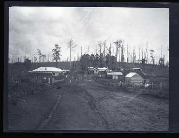
... Gembrook Ranges Hotel Ferntree Gully to Gembrook Railway General Store Main Road early 20th century Handwritten on (not original) packet containing negative: 'Gembrook township' Black and white negative - landscape view - showing the main road in Gembrook heading west. ...This negative is one of a batch of ten images taken apparently around the same time at Gembrook c. early 20th century. This negative of the main road features two historic buildings, the Ranges Hotel and the General Store as well as a few houses and the railway station. The General Store was built in front of the railway station.This negative shows former iconic and historical buildings in Gembrook.Black and white negative - landscape view - showing the main road in Gembrook heading west. The last building on the left is the Ranges Hotel and the second last building on the right is the double-gabled General Store which fronts the railway station. This negative has been kept inside a packet which is not original.Handwritten on (not original) packet containing negative: 'Gembrook township'gembrook, ranges hotel, ferntree gully to gembrook railway, general store, main road, early 20th century -
 Ararat & District Historical Society (operating the Langi Morgala Museum)
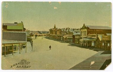
Postcard, Barkly Street Ararat
... township in its early stages of colonialisation and reflects on the style of early architecture. The image is a photographic representation of wide streets, assorted businesses and buildings with a bicyclist and horse-drawn carriage in the background. The vantage point seems to be the balcony of Leopolds hotel...township in its early stages of colonialisation and reflects on the style of early architecture. The image is a photographic representation of wide streets, assorted businesses and buildings with a bicyclist and horse-drawn carriage in the background. The vantage point seems to be the balcony of Leopolds hotel ...Barkly Street is the main road into the business district of Ararat and has developed significantly since this image was taken. The postcard helps define the township in its early stages of colonialisation and reflects on the style of early architecture. The image is a photographic representation of wide streets, assorted businesses and buildings with a bicyclist and horse-drawn carriage in the background. The vantage point seems to be the balcony of Leopolds hotel. This early 1900s streetscape assists in the understanding of our township's development over the decades, both socially and architecturally.Small, landscape orientation rigid postcard, colourised, featuring Barkly Street in Ararat, circa 1900s. Notable features are the Turf Hotel sign and the lettering 'Yankee Doodle' on a building wall.Front: "Barkly Street Ararat". barkly street, ararat, 1900s, buildings, streetscape, architecture, postcard, colourised, turf hotel, leopolds hotel -
 Orbost & District Historical Society
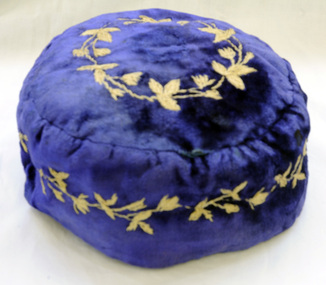
smoking cap, late 19th century
... township. James stirling arrived in Victoria from Scotland in 1842.He took over Corringle Station (Ewing's Marsh). His son James stirling later established theMarlo Hotel. ...township. James stirling arrived in Victoria from Scotland in 1842.He took over Corringle Station (Ewing's Marsh). His son James stirling later established theMarlo Hotel. ...Smoking Caps are caps worn by men while smoking to stop the hair from smelling of smoke. They also kept the head warm. They were popular in the period 1840-1880, usually worn by gentlemen in the privacy of their home. This beautiful velvet smoking cap was worn by James Stirling who was the first settler to occupy land in the Marlo township. James stirling arrived in Victoria from Scotland in 1842.He took over Corringle Station (Ewing's Marsh). His son James stirling later established theMarlo Hotel. (Read more in Mary Gilbert’s book)Smoking accessories like this cap were popular through the mid-to-late nineteenth century to prevent the smoker's hair from absorbing the smell of tobacco smoke and were often worn with smoking jackets. The design, with its elaborate embroidery shows an aspect of Victorian material culture and reflects the nineteenth-century love of 'Oriental' style. . A domed shaped smoking cap of blue velvet .It is lined with silk. The tops and sides are embroidered with tan coloured leaves. head-coverings stirling-james smoking-cap -
 Orbost & District Historical Society
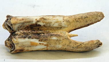
tooth
... By 1884, this structure had expanded to a 9 roomed accommodation house and in 1886 became the Marlo Hotel when a liquor license was granted. info. from Personalities and Stories of the Early Orbost District by Mary Gilbert. The first settler to occupy the Marlo township area was James Stirling around the year 1875. tooth stirling molar equine An old horse tooth. ...This was dug up at the old station at Lochend owned by the Stirling family and abandoned in the early 1870's. James Stirling's son Thomas Telfer Stirling took up the Corringle Run stretching from Lake Tyers along the coast. The home was at the Old Station. When he moved to Bruthen, James Stirling took over the Corringle Station. He is buried in the Marlo cemetery. He built a bark hut on the bluff that had two rooms, bark walls, earthen floors and a shingle roof. By 1884, this structure had expanded to a 9 roomed accommodation house and in 1886 became the Marlo Hotel when a liquor license was granted. info. from Personalities and Stories of the Early Orbost District by Mary Gilbert. The first settler to occupy the Marlo township area was James Stirling around the year 1875.An old horse tooth. Probably from before 1920. It is a molar.tooth stirling molar equine -
 Orbost & District Historical Society
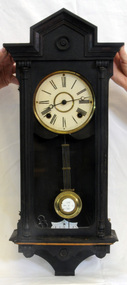
wall clock, c. late 19th century
... This hotel was the first in the area and cost 1,400 pounds to build (ref. In Times Gone By - Deborah Hall) and was actually built before Orbost was proclaimed a township - April 17 1885 The R A on the pendulum stands for: retard/advance. ...The Orbost Club Hotel was the first hotel built in the Orbost district and was an important hub for the township with many whole town meetings held there. wall-clock orbost-club-hotel R A on the pendulum. ...The clock was the original clock located over the bar in the Orbost Club Hotel. In 1884 J.A. Petterson built the first Orbost Club Hotel with the licence in the name of Thomas Maguire (his stepson). This hotel was the first in the area and cost 1,400 pounds to build (ref. In Times Gone By - Deborah Hall) and was actually built before Orbost was proclaimed a township - April 17 1885 The R A on the pendulum stands for: retard/advance. It is a common pendulum bob, used by many manufacturers, worldwide. Regulator clocks, sometimes referred to as pendulum clocks, were invented in the late 18th century in a quest for greater timekeeping accuracy. They were weight-driven devices. The pendulum on this clock appears to be German made. .The Orbost Club Hotel was the first hotel built in the Orbost district and was an important hub for the township with many whole town meetings held there.A wall clock with Roman numerals inside a dark brown wooden case. It has a brass pendulum and the key is inside the case.R A on the pendulum.wall-clock orbost-club-hotel -
 Eltham District Historical Society Inc
Negative - Photograph, Coghill & Haughton, On the banks of the Plenty, c.1924
... Hotel...houses...Lower Plenty...Lower Plenty Bridge...Lower Plenty Road...Main Road...Mrs M Thomas...Plenty River...Plenty Township...Eltham District Historical Society Inc 728 Main Rd Eltham melbourne Negative copy and associated print of detail from original Sales Brochure: Plenty Township Estate and Bryn Teg Hill's Estate, Coghill & Haughton, Melbourne (c.1924) Bridge Bryn Teg Bryn Teg Hill's Estate Coghill & Haughton Heidelberg Golf Club Hotel houses Lower Plenty Lower Plenty Bridge Lower Plenty Road Main Road Mrs M Thomas Plenty River Plenty Township Estate Real Estate Agent Sales Brochure Film - Agfa Ortho 25 Roll of 35mm Black and White negative film, 3 strips, (1 of 14 frames) Print 10 x 15 cm On the banks of the Plenty Negative Photograph Coghill & Haughton ...Negative copy and associated print of detail from original Sales Brochure: Plenty Township Estate and Bryn Teg Hill's Estate, Coghill & Haughton, Melbourne (c.1924)Roll of 35mm Black and White negative film, 3 strips, (1 of 14 frames) Print 10 x 15 cmFilm - Agfa Ortho 25bridge, bryn teg, bryn teg hill's estate, coghill & haughton, heidelberg golf club hotel, houses, lower plenty, lower plenty bridge, lower plenty road, main road, mrs m thomas, plenty river, plenty township estate, real estate agent, sales brochure -
 Eltham District Historical Society Inc
Negative - Photograph, Coghill & Haughton, Old bridge over the Plenty River near Plenty Hotel, c.1924
... Eltham District Historical Society Inc 728 Main Rd Eltham melbourne Negative copy and associated print of detail from original Sales Brochure: Plenty Township Estate and Bryn Teg Hill's Estate, Coghill & Haughton, Melbourne (c.1924) Bryn Teg Hill's Estate Coghill & Haughton Sales Brochure Lower Plenty Bridge hotels Lower-Plenty-Road Plenty-Hotel plenty-river Film - Agfa Ortho 25 Roll of 35mm Black and White negative film, 3 strips, (1 of 14 frames) Print 10 x 15 cm Old bridge over the Plenty River near Plenty Hotel Negative Photograph Coghill & Haughton ...Negative copy and associated print of detail from original Sales Brochure: Plenty Township Estate and Bryn Teg Hill's Estate, Coghill & Haughton, Melbourne (c.1924)Roll of 35mm Black and White negative film, 3 strips, (1 of 14 frames) Print 10 x 15 cmFilm - Agfa Ortho 25bryn teg hill's estate, coghill & haughton, sales brochure, lower plenty, bridge, hotels, lower-plenty-road, plenty-hotel, plenty-river -
 Eltham District Historical Society Inc
Photograph - Digital Photograph, Alan King, St Matthew's Church and Hall, Panton Hill, 27 March 2008
... Hotel de France. The building was also used for Sunday School, a school and a hall.1 The St Matthew’s Church and hall at the corner of Church Road and Kangaroo Ground-St Andrews Road, were built in the early 20th century in the standard rectangular style of the times. The intact belt of Radiata Pines was common at that time. The war memorial concrete cross is the area’s monument for the 20th century wars. It is much more modest than those in Eltham, and particularly in Kangaroo Ground, demonstrating those townships...Hotel de France. The building was also used for Sunday School, a school and a hall.1 The St Matthew’s Church and hall at the corner of Church Road and Kangaroo Ground-St Andrews Road, were built in the early 20th century in the standard rectangular style of the times. The intact belt of Radiata Pines was common at that time. The war memorial concrete cross is the area’s monument for the 20th century wars. It is much more modest than those in Eltham, and particularly in Kangaroo Ground, demonstrating those townships ...St. Matthew's Church has historic significance as the town's church and physical and social focus for the community. The standard design buildings are good examples and important streetscape elements. The war memorial cross is the area's monument to the 20th century wars and its modest scale in comparison with the granite Eltham and towered Kangaroo Ground memorials illustrates the lack of affluence in the town and surrounding area. The grouping of church, school, store and post office is typical of country villages throughout Victoria. The Radiata Pine plantings are significant as an intact line of shelterbelt planting typical of the early 20th century. (Bick Study 1992) Covered under Heritage Overlay, Nillumbik Planning Scheme. Published: Nillumbik Now and Then / Marguerite Marshall 2008; photographs Alan King with Marguerite Marshall.; p63 Panton Hill’s first church services were held in a simple building made of paling timber, opposite the Hotel de France. The building was also used for Sunday School, a school and a hall.1 The St Matthew’s Church and hall at the corner of Church Road and Kangaroo Ground-St Andrews Road, were built in the early 20th century in the standard rectangular style of the times. The intact belt of Radiata Pines was common at that time. The war memorial concrete cross is the area’s monument for the 20th century wars. It is much more modest than those in Eltham, and particularly in Kangaroo Ground, demonstrating those townships’ comparative affluence.2 Early settler J Hughes, who donated the land to the Church of England, was the first to be married at St Matthews when he married Rachel Coutie. In later life he became a minister of religion.3 One much-liked preacher was George Hollow, who with his sister playing the harmonium, conducted church services at Panton Hill, St Andrews and Christmas Hills, for many years.This collection of almost 130 photos about places and people within the Shire of Nillumbik, an urban and rural municipality in Melbourne's north, contributes to an understanding of the history of the Shire. Published in 2008 immediately prior to the Black Saturday bushfires of February 7, 2009, it documents sites that were impacted, and in some cases destroyed by the fires. It includes photographs taken especially for the publication, creating a unique time capsule representing the Shire in the early 21st century. It remains the most recent comprehenesive publication devoted to the Shire's history connecting local residents to the past. nillumbik now and then (marshall-king) collection, panton hill, st matthew's church, panton hill war memorial -
 Eltham District Historical Society Inc
Photograph - Digital Photograph, Alan King, Former Police Residence, 728 Main Road, Eltham, 28 December 2007
... township, defined centralised control over law and order. In the early days the Police Constable in charge would conduct his duties travelling around the district by horse; a stable was located at the rear of the residence. At times the horse would be grazed on the paddocks across the road. Horseshoes were forged by the blacksmith beside the Courthouse on the high side of “Policeman’s Hill”. Along with the stable, there was a two-cell bluestone lockup where prisoners were held awaiting trial in the adjacent Courthouse. Their meals were usually provided by the policeman’s wife or from the hotel...township, defined centralised control over law and order. In the early days the Police Constable in charge would conduct his duties travelling around the district by horse; a stable was located at the rear of the residence. At times the horse would be grazed on the paddocks across the road. Horseshoes were forged by the blacksmith beside the Courthouse on the high side of “Policeman’s Hill”. Along with the stable, there was a two-cell bluestone lockup where prisoners were held awaiting trial in the adjacent Courthouse. Their meals were usually provided by the policeman’s wife or from the hotel ...The institutions of law and order in Colonial Victoria included the police, courts and prisons. The 1852 report of the Snodgrass Select Committee appointed to "identify the policing needs of the colony” noted there existed seven independent police forces that did not co-operate or regularly communicate. Following the committee's report all these police entities were merged into the Victoria Police, founded on 8 January 1853, to implement law and order responsibilities throughout the Colony of Victoria. The Eltham Courthouse (1860) and adjacent Police Residence (1859) formed a justice precinct established in the immediate aftermath of the 1852 police inquiry and the effects of the gold rush. The physical presence of these buildings, in the centre of the early Eltham township, defined centralised control over law and order. In the early days the Police Constable in charge would conduct his duties travelling around the district by horse; a stable was located at the rear of the residence. At times the horse would be grazed on the paddocks across the road. Horseshoes were forged by the blacksmith beside the Courthouse on the high side of “Policeman’s Hill”. Along with the stable, there was a two-cell bluestone lockup where prisoners were held awaiting trial in the adjacent Courthouse. Their meals were usually provided by the policeman’s wife or from the hotel just up the road. With the arrival of the railway in 1902 the town centre gradually shifted towards the railway station. The Police Station and operations were moved into the town centre in 1961 to a renovated house in Pryor Street, which was later replaced by the current Police Station. From 1961-1981 the residence was occupied by the Vermin and Noxious Weeds Destruction Section of the Department of Crown Lands and Survey. Prior to August 1967 the former Police Station was dragged to the rear of Police Residence to make way for the construction of a driveway and access from Main Road. The building was placed on the site of a former Scullery and modified for Lands Department use. In 1981 the Shire of Eltham took over management of the former Police Residence in Eltham. It remained unoccupied for a period whilst its future was discussed in Council. It was then used for a community job creation scheme until 1985. In 1985 the Shire of Eltham Parks and Environment occupied the residence. Council improved the driveway but later added a second rear access from Brougham Street due to the dangerous nature of the Main Road entrance. Additionally, a rear toilet facility between the Police Residence and the relocated former Police Station, which was doubling up as a lunchroom. Council also commenced discussions to re-establish a replica Police Station. Around November 1986 the former Police Station was demolished; believed to have been suffering termite damage. About 1989, after some years of discussion, a replica Police Station was built, based on photographs, to act as a lunchroom and meeting room for the Parks and Environment staff and volunteers doing community service. In 1996 Eltham District Historical Society held discussions with Nillumbik Shire Council commissioners throughout the year regarding a home for the Society. A proposal was put forward by the Society in October to occupy the former Police Residence. In March 1997 Eltham District Historical Society gained access to former Police Residence and on July 12, 1998, moved into its Local History Centre. In July 2018, Eltham District Historical Society gained access to the replica Police Station (which had been used as a music library and storage for the Eltham Concert Band) for use as part of regular heritage tours for schools and community-based groups. Covered under Heritage Overlay, Nillumbik Planning Scheme. Published: Nillumbik Now and Then / Marguerite Marshall 2008; photographs Alan King with Marguerite Marshall.; p65This collection of almost 130 photos about places and people within the Shire of Nillumbik, an urban and rural municipality in Melbourne's north, contributes to an understanding of the history of the Shire. Published in 2008 immediately prior to the Black Saturday bushfires of February 7, 2009, it documents sites that were impacted, and in some cases destroyed by the fires. It includes photographs taken especially for the publication, creating a unique time capsule representing the Shire in the early 21st century. It remains the most recent comprehenesive publication devoted to the Shire's history connecting local residents to the past. nillumbik now and then (marshall-king) collection, eltham, main road, eltham district historical society, eltham justice precinct, little eltham, local history centre, police residence, police station -
 Eltham District Historical Society Inc
Photograph - Digital Photograph, Alan King, St Andrews Anglican Church, St Andrews, 30 January 2008
... The church and school then stood close to European and Chinese stores, three hotels, a brewery and a quartz mill.2 In 1861, Queenstown was officially proclaimed a township. ...The church and school then stood close to European and Chinese stores, three hotels, a brewery and a quartz mill.2 In 1861, Queenstown was officially proclaimed a township. ...Built c.1868, St Andrew’s Anglican Church is Nillumbik Shire’s oldest timber church and is historically, socially, and spiritually significant to the Shire of Nillumbik. The church is historically significant because it may have given its name 'St Andrews' to the town (another suggestion is that the name came from the local hotel), it is also historically significant as one of only four buildings that remain from the Caledonian goldfields era of Queenstown (now St Andrews) and one of only a handful of buildings that survived the 1960s bushfires. The church is historically, socially, and spiritually significant because it has played an important part in community life for more than 150 years; a proposal to move the church in 1984 met with strenuous opposition. Much of the fires on Black Saturday 2009 were the north of the town. The town itself remained intact - as did this heritage building. Covered under Heritage Overlay, Nillumbik Planning Scheme. National Trust of Australia (Victoria) Local significance Published: Nillumbik Now and Then / Marguerite Marshall 2008; photographs Alan King with Marguerite Marshall.; p69 The St Andrews Anglican Church and former St Andrews Primary School, are two reminders of the district’s early days, when it was founded on gold. St Andrews, then called Queenstown, was the earliest goldfield in the Caledonia Diggings.1 It was the Upper Diamond Gold Mining and Administrative Centre, with 3000 miners. Queenstown was also the seat of the Court of Petty Sessions. The church and school then stood close to European and Chinese stores, three hotels, a brewery and a quartz mill.2 In 1861, Queenstown was officially proclaimed a township. From 1865, the name Queenstown was interchangeable with St Andrews, until 1952, when the town was officially named St Andrews. As gold declined from the early 1880s, Queenstown changed dramatically into a settlement of small farms. St Andrew’s Anglican Church, built in 1868, is the Shire’s oldest timber church and possibly gave its name to the township.3 The small timber church was opened on November 1, 1869, by the Dean of Melbourne. Anniversary tea meetings helped raise funds, and in 1889, a three-bedroom parsonage was built alongside. In 1910, the vicar, the Rev Selwyn Chase (and friend of the Scouting Movement’s founder, Baden Powell), established the 1st Queenstown Scout Troop, only two years after Scouting began in Australia. The church was important to the lives of many local residents who were baptised, married and had funeral services there. But by the 1950s the population had decreased and so did the weekly attendances. Around the mid-1960s the church closed, then fell into disrepair. So in the mid 1980s it was sold to the Education Department and was under threat of relocation or demolition. However this caused such opposition from locals,4 that instead, the Anglican church leased it as part of the Panton Hill parish5 and it was reconsecrated in 1987. Queenstown’s first school was held in a tent after transferring from Andersons Creek, Warrandyte.6 From 1858 a church school, Caledonia Diggings, stood west of the main road, a quarter of a mile (0.4km) before Buttermans Track. In 1882 the school was moved from a leased building, owned by headmaster Robert Harris, into a larger building on the corner of the School and the Heidelberg-Kinglake Roads. It had been moved from Smiths Gully and included a teacher’s three-roomed residence.7 In 1887 the school was replaced by the Queenstown State School No 128, although it was also called Caledonia Diggings until 1891. In 1956 it was renamed St Andrews. Still standing, this building is now used as the St Andrews Community Centre and the residence is leased for private use. The original timber-lined room remains alongside the extensions, and is distinctive with its high ceiling and tall small-paned windows. In 1984 a new school was built 500 metres west of the old school. Many residents have contributed much to St Andrews but one family that has done so for several generations is the Harris family. Robert Harris was an active member of the St Andrew’s Anglican Church, and worked hard at improving the town’s amenities until his death in 1887. He was a signatory to the successful 1863 petition to the Chief Commissioner of Police, against the proposed removal of the Court of Petty Sessions and police station at the Caledonia Diggings. The police station stayed in the town until 1917. Harris was Head Teacher of Queenstown State School from 1864 to 1874, then of the Smiths Gully school until it closed in 1882, and he continued teaching at Panton Hill until his death. His son, Robert Charles Harris, was editor and printer of the local newspaper, The Evelyn Observer, from 1873 until 1915. Robert’s son, William Shelley Harris, served in the Boer War and in World War One. In 1928 he became Kinglake National Park’s first park ranger. Robert’s daughter Elizabeth, taught needlework at Queenstown State School, and later ran the post office in Kinglake.This collection of almost 130 photos about places and people within the Shire of Nillumbik, an urban and rural municipality in Melbourne's north, contributes to an understanding of the history of the Shire. Published in 2008 immediately prior to the Black Saturday bushfires of February 7, 2009, it documents sites that were impacted, and in some cases destroyed by the fires. It includes photographs taken especially for the publication, creating a unique time capsule representing the Shire in the early 21st century. It remains the most recent comprehenesive publication devoted to the Shire's history connecting local residents to the past. nillumbik now and then (marshall-king) collection, st andrews, st andrews anglican church