Showing 147 items matching "travel bound"
-
 Eltham District Historical Society Inc
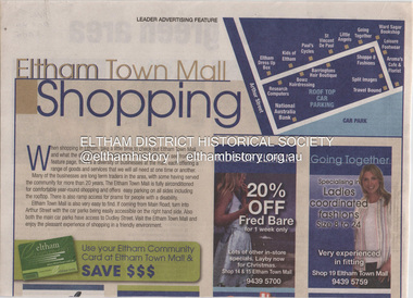
Document - Property Binder, Eltham Mall, 10-18 Arthur Street, Eltham
... ...Travel Bound...Advertisement: Huge Bikle Sale, Paul's Cycles, Diamond Valley Leader, February 7, 2007 Eltham Businesses Eltham Town Mall Paul's Cycles shops Brushtailed phascogale Click here to add keywords Cr Greg Johnson Eltham Copper Butterfly Environment Victoria Environmental Significance Overlay Green Wedges Coalition Nillumbik Shire Council Powerful Owl Significant Landscape Overlay Victorian National Parks Association Aroma's Cafe and Florist Arthur Street Barringtons Hair Boutique Bowz Hairdressing Eltham Dress Up Box Going Together Kids of Eltham Leisure Footwear Little Angels National Australia Bank Research Computers Shoppe 8 Fashions Split Images St Vincent de Paul Travel Bound Ward Sagar Bookshop Miscellaneous clippings, notes, photocopies, etc held on the subject property. ...1. Eltham Town Mall Shopping, Diamond Valley Leader, October 26, 2005 [ On reverse - "Red alert for green area by Natalie Birch and Shane Woodrow about a report compiled by Environment Victoria, Melbourne's Threatened Habitats Under Threat: Development Pressures and Conservation Solutions which places the 'Nillumbik Foothills' number seven on list of most endangered by urban sprawl] 2. Advertisement: Huge Bikle Sale, Paul's Cycles, Diamond Valley Leader, February 7, 2007eltham, businesses, eltham town mall, paul's cycles, shops, brushtailed phascogale, click here to add keywords, cr greg johnson, eltham copper butterfly, environment victoria, environmental significance overlay, green wedges coalition, nillumbik shire council, powerful owl, significant landscape overlay, victorian national parks association, aroma's cafe and florist, arthur street, barringtons hair boutique, bowz hairdressing, eltham dress up box, going together, kids of eltham, leisure footwear, little angels, national australia bank, research computers, shoppe 8 fashions, split images, st vincent de paul, travel bound, ward sagar bookshop -
 Tatura Irrigation & Wartime Camps Museum
Book, Das Land Ohne Herz, 1942
... Hard cover, bound German travel book. Subject : A trip in unknown America...Tatura Irrigation & Wartime Camps Museum 49 Hogan Street Tatura the-murray Property of internee at Camp 3, Tatura book das land ohne herz bissinger g wied g camp 3 tatura ww2 books history local travel J 205 Hard cover, bound German travel book. Subject : A trip in unknown America Das Land Ohne Herz Book ...Property of internee at Camp 3, TaturaHard cover, bound German travel book. Subject : A trip in unknown AmericaJ 205book, das land ohne herz, bissinger g, wied g, camp 3, tatura, ww2, books, history, local, travel -
 Australian National Surfing Museum
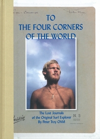
Book, Flying Pineapple Media, To The Four Corners Of The World, 1/1/2011 (estimated)
... Full colour, hard bound travel surf book by Peter Troy OAM, edited by Brendan McAloon. ...This book is a unique record of world travel by surfer(s)during this period. torquay rod brooks surf bells beach peter troy rennie ellis hawaii nias vic tantau terry wall bells beach surf contest brazil world surfing championships biarritz european surfing championships flying pineapple media sean doherty ISBN - 978-0-9808480-0-7 Full colour, hard bound travel surf book by Peter Troy OAM, edited by Brendan McAloon. ...This book is the definitive history of the surf travels by Peter Troy. Troy's travels are the stuff of legends. An original and influential figure in the early days of surfing at Bells Beach, Troy left Australia in 1963 and roamed the planet with surfboard under arm from Europe to Hawaii, South America to South Africa, introducing surfing to Brazil and discovering untold perfect waves like Nias off the coast of Sumatra. He documented every step of this remarkable journey in letters home which were rediscovered after his untimely death in 2008.This book represents the major surf travel history of one of the great legends in world surfing Peter Troy from Torquay. In 1962 Troy was one of the founders of the Bells Beach Surf Contest, the longest running surf contest in the world. He was an intrepid surf traveller who during the period 1963-1966 introduced surfing to the country of Brazil and explored the four corners of the globe for waves. This book is a unique record of world travel by surfer(s)during this period.Full colour, hard bound travel surf book by Peter Troy OAM, edited by Brendan McAloon. Colour cover image of a young Peter Troy by Rennie Ellis.ISBN - 978-0-9808480-0-7torquay, rod brooks, surf, bells beach, peter troy, rennie ellis, hawaii, nias, vic tantau, terry wall, bells beach surf contest, brazil, world surfing championships, biarritz, european surfing championships, flying pineapple media, sean doherty -
Glenelg Shire Council Cultural Collection
Functional object - Jug recovered from wreck of Geltwood, n.d
... She was on her maiden voyage travelling from Liverpool and bound for Melbourne. There were no survivors....She was on her maiden voyage travelling from Liverpool and bound for Melbourne. There were no survivors. ...Found on Geltwood ship wreck by Abalone Diver in the early 1990s. The Geltwood was an iron-hulled barque which was wrecked off the coast of South Australia in June of 1876. She was on her maiden voyage travelling from Liverpool and bound for Melbourne. There were no survivors.Geltwood shipwreckCeramic jug with part of spout and rim broken. Brown/tan stain fired. No lid. Some encrustations on handle and rim.geltwood, shipwreck, diving, jug, domestic -
 Ballarat Tramway Museum
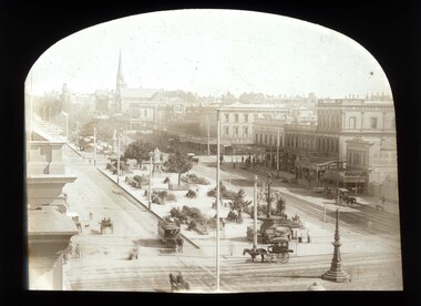
Photograph - Digital image, c1900
... Digital image of a horse tram travelling east bound in Sturt St near the corner of Armstrong St, c1900. ...Trams tramways Sturt St Horse Trams Town Hall Horse Cabs Digital image of a horse tram travelling east bound in Sturt St near the corner of Armstrong St, c1900. ...Yields information about the Sturt St west of the Town Hall c1900 and horse tram operations.Digital image of a horse tram travelling east bound in Sturt St near the corner of Armstrong St, c1900. Photo taken from the Town Hall clock tower. Note the horse drawn cabs, building on the north side of Sturt St, Art Gallery Association, Craig's, stores Woodrow's Hats and Jago Boots. George Crocker's store and HP White side building. Made from a scan of a Magic Lantern slide by John Hyett, ([email protected]) June 2010. See email to Secretary dated 21/6/2010 copy with the worksheet file.trams, tramways, sturt st, horse trams, town hall, horse cabs -
 Ballarat Tramway Museum
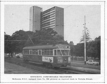
Photograph - Illustration/s, PCC 980 Victoria Parade
... Black and white illustration of MMTB PCC 980 travelling west bound in Victoria Parade between Nicholson St and Spring St., possibly late 1950's. ...Ballarat Tramway Museum South Gardens Reserve Wendouree Parade Ballarat Ballarat goldfields Trams tramways PCC MMTB Victoria Parade Black and white illustration of MMTB PCC 980 travelling west bound in Victoria Parade between Nicholson St and Spring St., possibly late 1950's. ...Black and white illustration of MMTB PCC 980 travelling west bound in Victoria Parade between Nicholson St and Spring St., possibly late 1950's. The tram showing destination of "Special". Has Penfolds Wine and Perfection ? ads on the sides of the tram. Also two ads on the front of the tram, but image not focused sharply enough to identify them. In the background is the ICI (now Orica) building. Caption on the illustration is "Efficient, Comfortable Transport. Melbourne P.C.C. equipped tram No. 980 pictured on reserved track in Victoria Parade." indicates probably from an electric traction or tramway publication.trams, tramways, pcc, mmtb, victoria parade -
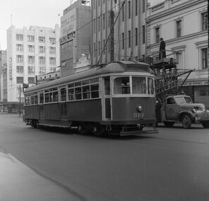 Ballarat Tramway Museum
Print, Geoff Grant, 19/06/1955 12:00:00 AM
... Melbourne alongside tower truck No. 2. Tram travelling west bound in Bourke St. just before Russell St. ...Melbourne alongside tower truck No. 2. Tram travelling west bound in Bourke St. just before Russell St. ...Negative No. N325 and black and white print made by a laser printer (stored in folder ) of W6 988 in Bourke St. Melbourne alongside tower truck No. 2. Tram travelling west bound in Bourke St. just before Russell St. Outside the Commercial Banking Company of Sydney Ltd. offices. Patersons ((furnishers) and Norman's corner stores - drapers building in view. See page 6 of Sands & McDougall's Directory of Melbourne 1968 for details. Negative scanned hi res and imaged updated 21/5/2020. Page 6 of 1968 Sands and McDougall's directory of Melbourne.trams, tramways, melbourne, bourke st., testing overhead, commissioning, tram w6 988 -
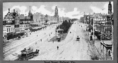 Ballarat Tramway Museum
Postcard, John Phillips, Sturt St. Ballarat at Grenville St
... Image is of a horse tram leave the Grenville St. terminus, to travel west bound along the north side of Sturt St. ...Image is of a horse tram leave the Grenville St. terminus, to travel west bound along the north side of Sturt St. ...B&W print and scanned images of a coloured postcard lent to the BTM by Mr. Norm DePomeroy, Dec. 1997. Image is of a horse tram leave the Grenville St. terminus, to travel west bound along the north side of Sturt St. Has many pedestrians in photo and some horse drawn vehicles. Shows the position of the horse tram track in Sturt St., north side, was not up against the south side kerb. Postcard has a Christmas message on the base of it. Also shows telegraph poles along the north side of Sturt St. 1 copy held at 8/98. Postcard dated 22 Dec. 1904 See Reg Item 2437.1, 2437.2 for original postcards held within the collection. See 836i3. In bottom of image are the words "Sturt Street, Ballarat, Vic" and "Wishing you a Merry Christmas and a Happy New Year. E.L."trams, tramways, horse trams, sturt st, postcards, grenville st. -
 Warrnambool and District Historical Society Inc.
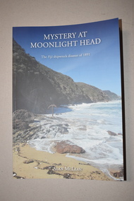
Book, Bart n Print Pty Ltd, Mystery at Moonlight Head, 2018
... The ship was travelling from Hamburg and bound for Melbourne when it was wrecked at Moonlight Head. ...The ship was travelling from Hamburg and bound for Melbourne when it was wrecked at Moonlight Head. ...This book written by Alan McLean records the historical details concerning the wreck of the Fiji at Moonlight Head, Victoria in 1891. The ship was travelling from Hamburg and bound for Melbourne when it was wrecked at Moonlight Head. Twelve lives were lost and a subsequent enquiry found the captain to be guilty of negligence. Residents of Warrnambool and district had some connection to the wreck as Joseph Jordan, a Warrnambool photographer, took photographs of the wreck scene and was involved in a controversy regarding the late arrival of rescue equipment and residents from the Warrnambool area were charged with stealing some of the wrecked cargo.This book is of considerable local interest as the wreck of the Fiji was connected with Warrnambool and district and affected many local residents.This is a soft cover book of 176 pages. It has a cover with a blue background, some printed material and two colour photographs. The book contains an acknowledgement, an introduction, 21 chapters and appendices. It also contains black and white and colour illustrations, maps and other images. To Warrnambool and District Historical Society With Best Wishes Alan McLeanwreck of the fiji, history of warrnambool, alan mclean, warrnambool photographer -
 Warrnambool and District Historical Society Inc.
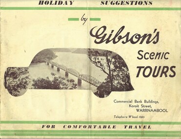
Booklet, Advertising Holiday Suggestions by Gibson's Scenic Tours, 1930s/40s
... The pages have information on Gibson’s Scenic Tours, Gibson’s Travel Club and the extended and day tours offered by the company. The booklet includes many black and white photographs of places visited on the tours. The booklet is bound...The pages have information on Gibson’s Scenic Tours, Gibson’s Travel Club and the extended and day tours offered by the company. The booklet includes many black and white photographs of places visited on the tours. The booklet is bound ...This booklet has been produced to advertise the tours offered by the Gibson’s Bus Services in Warrnambool in the late 1930s or early 1940s. The office of this bus service was situated in the Commercial Bank Buildings in Koroit Street, Warrnambool. This booklet is of interest because it shows the type of bus tours offered to Warrnambool people in the late 1930s and early 1940s. The tours were to Canberra and Sydney, Mount Gambier, Adelaide, Geelong, Ballarat, the Great Ocean Road and the Grampians. The buses could take 11 to 20 passengers. This is a soft cover booklet of eight pages produced as an advertising feature for Gibson’s Bus Services of Warrnambool. The cover has a yellow background with green lines on the edges. There is a sepia-coloured photograph on the front cover of a river scene encased in the shape of a bus and the back cover has three photographs of the buses used by the company. The pages have information on Gibson’s Scenic Tours, Gibson’s Travel Club and the extended and day tours offered by the company. The booklet includes many black and white photographs of places visited on the tours. The booklet is bound with metal staples. gibson’s bus services, history of warrnambool, warrnambool tourism, warrnambool -
 Warrnambool and District Historical Society Inc.
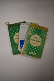
Notebooks, Flexibound Books, 1970s
... bound with yellow tape. The pages are loose. They have handwritten material concerning car travel. ...bound with yellow tape. The pages are loose. They have handwritten material concerning car travel. ...These notebooks were used by Charles and Vida Williams when they were Post Master and Post Mistress at the Nullawarre Post Office in the mid 20th century. Nullawarre is a small settlement 25 kilometres south east of Warrnambool and is a largely agricultural area. European settlement began in the area in the late 1860s. These notebooks are of minor interest as ones used by Charles and Vida Williams when they ran the Nullawarre Post Office in the mid 20th century. .1 This is a small notebook with a green cover bound with yellow tape. The pages are loose. They have handwritten material concerning car travel. Originally there were 100 pages but there are now fewer than this. .2 This is a small notebook similar to the one above except that it is bound with green tape and the pages are intact. It contains handwritten information on food expenses. .3 This is a small notebook with a blue cover and metal spiral binding. It contains handwritten material of a personal nature – addresses etc. Most of the pages are blank. ‘Pocket Notebook’nullawarre post office, charles & vida williams, nullawarre, history of warrnambool -
 Federation University Historical Collection
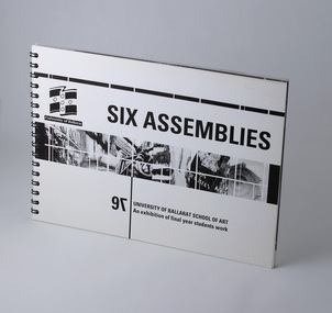
Booklet - Exhibition Catalogue, Six Assemblies, University of Ballarat, School of Art, 1997
... travel awards by Anne Saunders. Book sectioned by study areas, including photos of students, contact details and an example of their work. Final page includes list of sponsors, award donors, exhibition committee and designers. University of Ballarat Federation University Ceramics Drawing Graphics Graphic Design Printmaking Sculpture. Catalogue accompanying exhibition of final year, Visual Arts student work at University of Ballarat, 1997. Spiral bound ...Foreword by Associate Professor Robert L Allan, Head, School of Arts, University of Ballarat. Information regarding travel awards by Anne Saunders. Book sectioned by study areas, including photos of students, contact details and an example of their work. Final page includes list of sponsors, award donors, exhibition committee and designers.Catalogue accompanying exhibition of final year, Visual Arts student work at University of Ballarat, 1997. Spiral bound landscape book, 36 leaves (72pp) plus card covers front and back. Single colour black and white print throughout.university of ballarat, federation university, ceramics, drawing, graphics, graphic design, printmaking, sculpture. -
 J. Ward Museum Complex
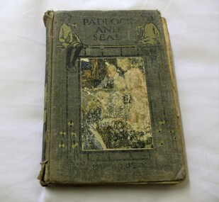
Book, Under Padlock and Seal 1905
... bound back to England. He was brought up by an aunt who sent him to Eton and then settled with him in Edinburgh. Avery took a job in the city’s Water Department and in 1894 wrote his first book The Orderly Officer. In the next 45 years he wrote over fifty more books, mainly school stories and adventure stories. In 1941 he left Scotland to travel ...A classic detective story. Harold Avery was born in 1869. His life reads like one of his own adventure stories. He was shipwrecked off the coast of Malaysia at the age of ten on his way to Australia with his parents who were drowned. Avery was brought up by the natives who, after three years put him on a Dutch boat bound back to England. He was brought up by an aunt who sent him to Eton and then settled with him in Edinburgh. Avery took a job in the city’s Water Department and in 1894 wrote his first book The Orderly Officer. In the next 45 years he wrote over fifty more books, mainly school stories and adventure stories. In 1941 he left Scotland to travel round the world and the last that was heard from him was a postcard sent to his aunt from Rio de Janeiro in 1943. It is chosen from his large output as being a typical school story but, it can be argued, it is the precursor of work by Enid Blyton and J K Rowling, dealing with school life, five children who go on an adventure and a mystical wizard who ends the story not with a wave of a wand but with kindness and consideration.fictionA classic detective story. Harold Avery was born in 1869. His life reads like one of his own adventure stories. He was shipwrecked off the coast of Malaysia at the age of ten on his way to Australia with his parents who were drowned. Avery was brought up by the natives who, after three years put him on a Dutch boat bound back to England. He was brought up by an aunt who sent him to Eton and then settled with him in Edinburgh. Avery took a job in the city’s Water Department and in 1894 wrote his first book The Orderly Officer. In the next 45 years he wrote over fifty more books, mainly school stories and adventure stories. In 1941 he left Scotland to travel round the world and the last that was heard from him was a postcard sent to his aunt from Rio de Janeiro in 1943. It is chosen from his large output as being a typical school story but, it can be argued, it is the precursor of work by Enid Blyton and J K Rowling, dealing with school life, five children who go on an adventure and a mystical wizard who ends the story not with a wave of a wand but with kindness and consideration.#detectivestory, fiction, adventurebook, boysownadventure -
Federation University Historical Collection
Book - Book - Scrapbook, Ballarat School of MInes: Scrapbook of Newspaper Cuttings, Book 53, August 1992 to October 1992
... The papers concerned are The Courier, Ballarat, The Australian, The Age over the period of 6 August 1992 to 28 October 1992. teaching positions advertised pre-employment courses courses available enrolment for smb courses donna tregenza kim raynor sharren galvin studies pay off victorian budgetgains short lived tafe week l f j hillman medal smb training restaurant tafe students' travelling show horticultural work offered to jobless michael kern michael murphy first and second in vacc awards clinton miller mechanical design drafting cultural instructors' course graduates staff and students reunion smb committed to enrichment disability week mechanics show their skill work skill competition disabled cam make a difference top apprentices out of work shelley robinsonwins award lindy wuestewald cocktail winner sculpture exhibition paul robert donald winner of hillman award bill gribble new smb council president paul donald apprentice of the year Book with green cover, front, spiral bound. ...Collection of newspaper articles related to Ballarat School Of Mines.They cover activities and advertisements for staff. The papers concerned are The Courier, Ballarat, The Australian, The Age over the period of 6 August 1992 to 28 October 1992.Book with green cover, front, spiral bound. teaching positions advertised, pre-employment courses, courses available, enrolment for smb courses, donna tregenza, kim raynor, sharren galvin, studies pay off, victorian budgetgains short lived, tafe week, l f j hillman medal, smb training restaurant, tafe students' travelling show, horticultural work offered to jobless, michael kern, michael murphy, first and second in vacc awards, clinton miller mechanical design drafting, cultural instructors' course graduates, staff and students reunion, smb committed to enrichment, disability week, mechanics show their skill, work skill competition, disabled cam make a difference, top apprentices out of work, shelley robinsonwins award, lindy wuestewald cocktail winner, sculpture exhibition, paul robert donald, winner of hillman award, bill gribble new smb council president, paul donald apprentice of the year -
 Bendigo Historical Society Inc.
Book - ALBUM OF SONGS, 1912 - 1917
... Album of Songs selected and bound by the Rev Bruce Plowman. Carried by him on his camel train while travelling central Australia from 1912 - 1917 as the first patrol padre for the Rev John Flynn. ...Album of Songs selected and bound by the Rev Bruce Plowman. Carried by him on his camel train while travelling central Australia from 1912 - 1917 as the first patrol padre for the Rev John Flynn. ...Album of Songs selected and bound by the Rev Bruce Plowman. Carried by him on his camel train while travelling central Australia from 1912 - 1917 as the first patrol padre for the Rev John Flynn. Signature inside front cover R.B.Plowman. Plus 2 photographs and a precis written by his daughter Mrs Jean Whitla donor of book. Green embossed cardboard cover and paper.book, rev bruce plowman, music, rev bruce plowman. -
 The Beechworth Burke Museum
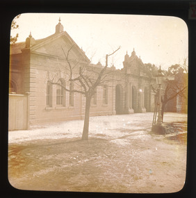
Photograph - Lantern Slide, c1900
... travel guide the 'Readers Digest Book of Historic Australian Towns'. Lantern slides, sometimes called 'magic lantern' slides, are glass plates on which an image has been secured for the purpose of projection. Glass slides were etched or hand-painted for this purpose from the Eighteenth Century but the process became more popular and accessible to the public with the development of photographic-emulsion slides used with a 'Magic Lantern' device in the mid-Nineteenth Century. Photographic lantern slides comprise a double-negative emulsion layer (forming a positive image) between thin glass plates that are bound...travel guide the 'Readers Digest Book of Historic Australian Towns'. Lantern slides, sometimes called 'magic lantern' slides, are glass plates on which an image has been secured for the purpose of projection. Glass slides were etched or hand-painted for this purpose from the Eighteenth Century but the process became more popular and accessible to the public with the development of photographic-emulsion slides used with a 'Magic Lantern' device in the mid-Nineteenth Century. Photographic lantern slides comprise a double-negative emulsion layer (forming a positive image) between thin glass plates that are bound ...This lantern slide shows the Ovens District Hospital (also called the Ovens Goldfields Hospital) in Beechworth in approximately 1900. The Hospital was built as part of a community push to develop the infrastructure needed for a permanent town in the 1850s. At the time there was no hospital located between Melbourne and the NSW town of Goulburn and it was recognised that the nature of mining and agricultural work predisposed people to serious injury. The community voted in 1853 to raise funds for a hospital and a voluntary committee elected from people who contributed £2 or more annually determined the organisation's management policies, which aimed to provide care for poor people at rates levied according to the person's means. Ongoing operations of the hospital were primarily supported by Government grants, however. The foundation stone was laid at a site in Church Street at a ceremony held 1st September 1856 which was attended by 2000 people using a locally crafted trowel with a tin ore handle and pure gold blade. The hospital, which was designed by J.H. Dobbyn, cost £2347. The hospital had two wards, a dispensary, apartments for a resident surgeon and the matron, an operating theatre and a board room. Further medical facilities including services to meet the cultural and health needs of the local Chinese community were later added, in addition to a Palladian-style cut-granite face built in 1862-63. It functioned as the region's primary hospital until surpassed by the Wangaratta Hospital in 1910. In the 1940s much of the building materials were salvaged and repurposed, with the exception of the facade which was restored in 1963 by the Beechworth Lions Club and still stands today. The facade featured on the covers of local history volume 'Beechworth: a Titan's Field' by Carole Woods and heritage-focused travel guide the 'Readers Digest Book of Historic Australian Towns'. Lantern slides, sometimes called 'magic lantern' slides, are glass plates on which an image has been secured for the purpose of projection. Glass slides were etched or hand-painted for this purpose from the Eighteenth Century but the process became more popular and accessible to the public with the development of photographic-emulsion slides used with a 'Magic Lantern' device in the mid-Nineteenth Century. Photographic lantern slides comprise a double-negative emulsion layer (forming a positive image) between thin glass plates that are bound together. A number of processes existed to form and bind the emulsion layer to the base plate, including the albumen, wet plate collodion, gelatine dry plate and woodburytype techniques. Lantern slides and magic lantern technologies are seen as foundational precursors to the development of modern photography and film-making techniques.This glass slide is significant because it provides insight into Beechworth's built environment and infrastructure in the early Twentieth Century, around the time of Australia's Federation. It is also an example of an early photographic and film-making technology in use in regional Victoria in the time period.Thin translucent sheet of glass with a round-edged square image printed on the front and framed in a black backing. It is held together by metal strips to secure the edges of the slide.Obverse: Y /burke museum, beechworth, lantern slide, slide, glass slide, plate, burke museum collection, photograph, monochrome, ovens district hospital, indigo shire, north-east victoria, hospital, palladian architecture, granite, community fundraising, community infrastructure, j.h. dobbyn, beechworth lions club, ovens goldfields hospital, chinese community -
 The Beechworth Burke Museum
Photograph - Lantern Slide, c1900
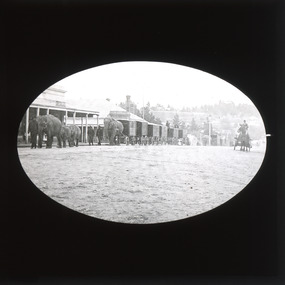
... traveling circuses use to have exotic animals such as elephants as part of their performances. Lantern slides, sometimes called 'magic lantern' slides, are glass plates on which an image has been secured for the purpose of projection. Glass slides were etched or hand-painted for this purpose from the Eighteenth Century but the process became more popular and accessible to the public with the development of photographic-emulsion slides used with a 'Magic Lantern' device in the mid-Nineteenth Century. Photographic lantern slides comprise a double-negative emulsion layer (forming a positive image) between thin glass plates that are bound...traveling circuses use to have exotic animals such as elephants as part of their performances. Lantern slides, sometimes called 'magic lantern' slides, are glass plates on which an image has been secured for the purpose of projection. Glass slides were etched or hand-painted for this purpose from the Eighteenth Century but the process became more popular and accessible to the public with the development of photographic-emulsion slides used with a 'Magic Lantern' device in the mid-Nineteenth Century. Photographic lantern slides comprise a double-negative emulsion layer (forming a positive image) between thin glass plates that are bound ...This slide depicts an image of elephants from a travelling circus being marched through Camp Street in Beechworth in the early 1900s. Travelling circuses began operation in Australia in the 1860s as a way of providing entertainment to towns across Australia. Many of these traveling circuses use to have exotic animals such as elephants as part of their performances. Lantern slides, sometimes called 'magic lantern' slides, are glass plates on which an image has been secured for the purpose of projection. Glass slides were etched or hand-painted for this purpose from the Eighteenth Century but the process became more popular and accessible to the public with the development of photographic-emulsion slides used with a 'Magic Lantern' device in the mid-Nineteenth Century. Photographic lantern slides comprise a double-negative emulsion layer (forming a positive image) between thin glass plates that are bound together. A number of processes existed to form and bind the emulsion layer to the base plate, including the albumen, wet plate collodion, gelatine dry plate and Woodburytype techniques. Lantern slides and magic lantern technologies are seen as foundational precursors to the development of modern photography and film-making techniques.This glass slide is significant because it provides insight into Beechworth's social amenities and religious infrastructure in the late Nineteenth Century. It is also an example of an early photographic and film-making technology in use in regional Victoria in the time period.Thin translucent sheet of glass with a square image printed on the front and framed in a black backing. It is held together by metals strips to secure the edges of the slide.burke museum, beechworth, lantern slide, slide, glass slide, plate, burke museum collection, photograph, monochrome, circus, travelling circus, elephants, circus elephants, exotic animals, 1900s, entertainment -
 The Beechworth Burke Museum
Photograph - Lantern Slide, c1900
... traveling circuses use to have exotic animals such as elephants as part of their performances. Lantern slides, sometimes called 'magic lantern' slides, are glass plates on which an image has been secured for the purpose of projection. Glass slides were etched or hand-painted for this purpose from the Eighteenth Century but the process became more popular and accessible to the public with the development of photographic-emulsion slides used with a 'Magic Lantern' device in the mid-Nineteenth Century. Photographic lantern slides comprise a double-negative emulsion layer (forming a positive image) between thin glass plates that are bound...traveling circuses use to have exotic animals such as elephants as part of their performances. Lantern slides, sometimes called 'magic lantern' slides, are glass plates on which an image has been secured for the purpose of projection. Glass slides were etched or hand-painted for this purpose from the Eighteenth Century but the process became more popular and accessible to the public with the development of photographic-emulsion slides used with a 'Magic Lantern' device in the mid-Nineteenth Century. Photographic lantern slides comprise a double-negative emulsion layer (forming a positive image) between thin glass plates that are bound ...This slide depicts an image of elephants from a travelling circus being marched through Camp Street in Beechworth in the early 1900s. Travelling circuses began operation in Australia in the 1860s as a way of providing entertainment to towns across Australia. Many of these traveling circuses use to have exotic animals such as elephants as part of their performances. Lantern slides, sometimes called 'magic lantern' slides, are glass plates on which an image has been secured for the purpose of projection. Glass slides were etched or hand-painted for this purpose from the Eighteenth Century but the process became more popular and accessible to the public with the development of photographic-emulsion slides used with a 'Magic Lantern' device in the mid-Nineteenth Century. Photographic lantern slides comprise a double-negative emulsion layer (forming a positive image) between thin glass plates that are bound together. A number of processes existed to form and bind the emulsion layer to the base plate, including the albumen, wet plate collodion, gelatine dry plate and Woodburytype techniques. Lantern slides and magic lantern technologies are seen as foundational precursors to the development of modern photography and film-making techniques.This glass slide is significant because it provides insight into Beechworth's social amenities and religious infrastructure in the late Nineteenth Century. It is also an example of an early photographic and film-making technology in use in regional Victoria in the time period.Thin translucent sheet of glass with an oval image printed on the front and framed in a black backing. It is held together by metals strips to secure the edges of the slide.burke museum, beechworth, lantern slide, slide, glass slide, plate, burke museum collection, photograph, monochrome, circus, travelling circus, elephants, circus elephants, exotic animals, 1900s, entertainment -
Phillip Island and District Historical Society Inc.
Trunk, 1890 approximate
... Over 100 years old. local history personal effects travel goods wooden trunk mrs ollie justice Large bound trunk with domed top. ...150 Year Trunk. Bought from Estate Mrs. Ollie Justice 1992. Over 100 years old.Large bound trunk with domed top. Painted blue. Leather handles each end. Binding and top braces with metal studs and edge flanges.local history, personal effects, travel goods, wooden trunk, mrs ollie justice -
 Phillip Island and District Historical Society Inc.
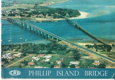
Booklet, Official Opening of the Phillip Island Bridge at San Remo 1969 and notes by the Bridge engineer, Tom Russell, 1969
... bound booklet with a photo of the old and new Phillip Island bridges on the cover and the CRB logo and name on rear. It includes the order of proceedings for the opening and bridge statistics, plans and contractor information. Also photos of construction and a history of travel...bound booklet with a photo of the old and new Phillip Island bridges on the cover and the CRB logo and name on rear. It includes the order of proceedings for the opening and bridge statistics, plans and contractor information. Also photos of construction and a history of travel ...Prior to 1939 access to the Island was by punt from San Remo or car ferry from Stony Point. A bridge was opened in 1940 but increased traffic and low load capacity was a problem. The decision to build a new bridge was made in the 1960s.HistoricalColoured, bound booklet with a photo of the old and new Phillip Island bridges on the cover and the CRB logo and name on rear. It includes the order of proceedings for the opening and bridge statistics, plans and contractor information. Also photos of construction and a history of travel to the Island before a bridge was built and the first bridge. There is also a 2 page typed document written by the bridge engineer who gives a brief history of access to the Island and problems at the opening with access and a rebel who tried to open it unofficially.Official Opening of the Phillip Island Bridge at San Remo by The Hon. M.V. Porter, MLA. Minister of Public Works. November 21 1969bridges, 2nd phillip island bridge construction, tom russell, phillip island bridge opening 1969 -
 Phillip Island and District Historical Society Inc.
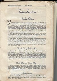
Book, Broadbent's Road Guide- Central Victoria Jubilee Edition, 1946
... travel guides. The Jubilee edition [ 50th] was probably printed in 1946. Historical Broadbent's Guides Guesthouses tourism Shops San remo koala cafe cowes Phillip Island A5 bound book, missing cover, broken binding, contains maps, photos, advertisements and information on tourist areas. ...Broadbents began in 1935 and produced many travel guides. The Jubilee edition [ 50th] was probably printed in 1946.HistoricalA5 bound book, missing cover, broken binding, contains maps, photos, advertisements and information on tourist areas.broadbent's guides, guesthouses, tourism, shops, san remo, koala cafe cowes, phillip island -
 Eltham District Historical Society Inc
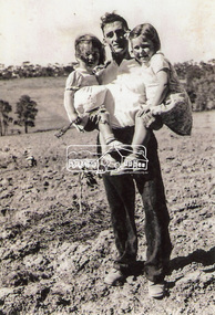
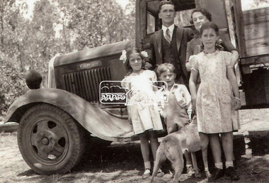
Photograph, Frank Stokes with daughters Dorothy (left) and Beryl (right) at Stokes Orchard, Nyora Road, Eltham, 1944, 1944
... bounded by Pitt Street, Eucalyptus Road and Wattle Grove) and they got talking over their common interest. Arthur put Frank up for the night and pointed out the land, part of Crown Allotment 15, Section 5, Parish of Nillumbik (CA15) somewhat diagonally opposite Bird Orchard. Frank bought the land and for the next two years would travel...bounded by Pitt Street, Eucalyptus Road and Wattle Grove) and they got talking over their common interest. Arthur put Frank up for the night and pointed out the land, part of Crown Allotment 15, Section 5, Parish of Nillumbik (CA15) somewhat diagonally opposite Bird Orchard. Frank bought the land and for the next two years would travel ...Frank Stokes first traveled to the district by train in 1944 to find land with the intention to establish an orchard. By chance he met Arthur Bird of Bird Orchard (bounded by Pitt Street, Eucalyptus Road and Wattle Grove) and they got talking over their common interest. Arthur put Frank up for the night and pointed out the land, part of Crown Allotment 15, Section 5, Parish of Nillumbik (CA15) somewhat diagonally opposite Bird Orchard. Frank bought the land and for the next two years would travel by train from Melbourne to Eltham every weekend establishing Stokes Orchard and building a home for his family, which they eventually moved into in 1946. In the mid 1970s the Shire of Eltham divided the orchard up into numerous rate-able parcel lots, which became affordable for Frank. As a consequence Stokes Orchard was turned into a housing development by Macquarie Builders and marketed as the Stokes Orchard Estate in two stages; Stage 1 encompassing Scarlet Ash Court, Ironbark Close and Peppermint Grove bounded by Nyora and Eucalyptus roads c.1976 and Stage 2 encompassing Stokes Place, Orchard Way, The Crest and The Lookout bound by Nyora and Diosma roads c.1979. The development of Orchard Way, The Crest and The Lookout did not proceed as planned due to the lack of the sewer along Diosma Road and so many of the proposed lots were incorporated into five-acre parcels instead.Representative of the orchard growing areas of ElthamDigital file only - Digitised by EDHS from a scrapbook (containing commercially printed photos of digital scans) on loan from Beryl Bradbury (nee Stokes), daughter of Frank Stokes.1944, beryl bradbury (nee stokes), beryl bradbury (nee stokes) collection, dorothy stokes, eltham, frank stokes, nyora road, stokes orchard -
 Eltham District Historical Society Inc
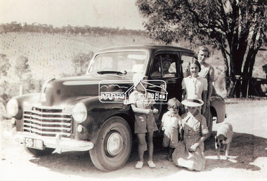
Photograph, Frank Stokes with his mother Florence (nee West) and children, Dorothy (left), David (centre) and Beryl (right), Stokes Orchard, Nyora Road, Eltham, c.1950, 1950c
... bounded by Pitt Street, Eucalyptus Road and Wattle Grove) and they got talking over their common interest. Arthur put Frank up for the night and pointed out the land, part of Crown Allotment 15, Section 5, Parish of Nillumbik (CA15) somewhat diagonally opposite Bird Orchard. Frank bought the land and for the next two years would travel...bounded by Pitt Street, Eucalyptus Road and Wattle Grove) and they got talking over their common interest. Arthur put Frank up for the night and pointed out the land, part of Crown Allotment 15, Section 5, Parish of Nillumbik (CA15) somewhat diagonally opposite Bird Orchard. Frank bought the land and for the next two years would travel ...Frank's mother Florence was visiting from England at the time. Frank Stokes first traveled to the district by train in 1944 to find land with the intention to establish an orchard. By chance he met Arthur Bird of Bird Orchard (bounded by Pitt Street, Eucalyptus Road and Wattle Grove) and they got talking over their common interest. Arthur put Frank up for the night and pointed out the land, part of Crown Allotment 15, Section 5, Parish of Nillumbik (CA15) somewhat diagonally opposite Bird Orchard. Frank bought the land and for the next two years would travel by train from Melbourne to Eltham every weekend establishing Stokes Orchard and building a home for his family, which they eventually moved into in 1946. In the mid 1970s the Shire of Eltham divided the orchard up into numerous rate-able parcel lots, which became affordable for Frank. As a consequence Stokes Orchard was turned into a housing development by Macquarie Builders and marketed as the Stokes Orchard Estate in two stages; Stage 1 encompassing Scarlet Ash Court, Ironbark Close and Peppermint Grove bounded by Nyora and Eucalyptus roads c.1976 and Stage 2 encompassing Stokes Place, Orchard Way, The Crest and The Lookout bound by Nyora and Diosma roads c.1979. The development of Orchard Way, The Crest and The Lookout did not proceed as planned due to the lack of the sewer along Diosma Road and so many of the proposed lots were incorporated into five-acre parcels instead.Representative of the orchard growing areas of ElthamDigital file only - Digitised by EDHS from a scrapbook (containing commercially printed photos of digital scans) on loan from Beryl Bradbury (nee Stokes), daughter of Frank Stokes.1950, beryl bradbury (nee stokes), beryl bradbury (nee stokes) collection, david stokes, dorothy stokes, eltham, flatbed truck, florence stokes (nee west), frank stokes, nyora road, stokes orchard -
 Eltham District Historical Society Inc
Photograph, Stokes family, Nyora Road, Eltham, c.1952, 1952c
... bounded by Pitt Street, Eucalyptus Road and Wattle Grove) and they got talking over their common interest. Arthur put Frank up for the night and pointed out the land, part of Crown Allotment 15, Section 5, Parish of Nillumbik (CA15) somewhat diagonally opposite Bird Orchard. Frank bought the land and for the next two years would travel...bounded by Pitt Street, Eucalyptus Road and Wattle Grove) and they got talking over their common interest. Arthur put Frank up for the night and pointed out the land, part of Crown Allotment 15, Section 5, Parish of Nillumbik (CA15) somewhat diagonally opposite Bird Orchard. Frank bought the land and for the next two years would travel ...Taken from outside the family home on the southest corner of the intersection of Nyora Road and Pitt Street with Eucalyptus Road, looking northeast across the Stokes Orchard L-R: David, Howard, Beryl (kneeling), Dorothy and Gladys Stokes with Gladys's mother sitting in Gladys's father's car with Spot the dog, Nyora Road, Eltham, c.1952 Frank Stokes first traveled to the district by train in 1944 to find land with the intention to establish an orchard. By chance he met Arthur Bird of Bird Orchard (bounded by Pitt Street, Eucalyptus Road and Wattle Grove) and they got talking over their common interest. Arthur put Frank up for the night and pointed out the land, part of Crown Allotment 15, Section 5, Parish of Nillumbik (CA15) somewhat diagonally opposite Bird Orchard. Frank bought the land and for the next two years would travel by train from Melbourne to Eltham every weekend establishing Stokes Orchard and building a home for his family, which they eventually moved into in 1946. In the mid 1970s the Shire of Eltham divided the orchard up into numerous rate-able parcel lots, which became affordable for Frank. As a consequence Stokes Orchard was turned into a housing development by Macquarie Builders and marketed as the Stokes Orchard Estate in two stages; Stage 1 encompassing Scarlet Ash Court, Ironbark Close and Peppermint Grove bounded by Nyora and Eucalyptus roads c.1976 and Stage 2 encompassing Stokes Place, Orchard Way, The Crest and The Lookout bound by Nyora and Diosma roads c.1979. The development of Orchard Way, The Crest and The Lookout did not proceed as planned due to the lack of the sewer along Diosma Road and so many of the proposed lots were incorporated into five-acre parcels instead.Representative of the orchard growing areas of ElthamDigital file only - Digitised by EDHS from a scrapbook (containing commercially printed photos of digital scans) on loan from Beryl Bradbury (nee Stokes), daughter of Frank Stokes.1948-1951 vauxhall velox, 1948-1951 vauxhall wyvern, 1952, beryl bradbury (nee stokes), beryl bradbury (nee stokes) collection, david stokes, dorothy stokes, eltham, gladys stokes, nyora road, spot (dog), stokes orchard -
 Eltham District Historical Society Inc
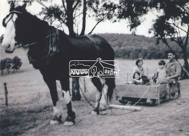
Photograph, Stokes family with horse and sled, Nyora Road, Eltham, c.1950, 1950c
... bounded by Pitt Street, Eucalyptus Road and Wattle Grove) and they got talking over their common interest. Arthur put Frank up for the night and pointed out the land, part of Crown Allotment 15, Section 5, Parish of Nillumbik (CA15) somewhat diagonally opposite Bird Orchard. Frank bought the land and for the next two years would travel...bounded by Pitt Street, Eucalyptus Road and Wattle Grove) and they got talking over their common interest. Arthur put Frank up for the night and pointed out the land, part of Crown Allotment 15, Section 5, Parish of Nillumbik (CA15) somewhat diagonally opposite Bird Orchard. Frank bought the land and for the next two years would travel ...Taken from outside the family home on the southest corner of the intersection of Nyora Road and Pitt Street with Eucalyptus Road, looking northeast across the Stokes Orchard Frank Stokes with children, Dorothy (left), Beryl and David Frank Stokes first traveled to the district by train in 1944 to find land with the intention to establish an orchard. By chance he met Arthur Bird of Bird Orchard (bounded by Pitt Street, Eucalyptus Road and Wattle Grove) and they got talking over their common interest. Arthur put Frank up for the night and pointed out the land, part of Crown Allotment 15, Section 5, Parish of Nillumbik (CA15) somewhat diagonally opposite Bird Orchard. Frank bought the land and for the next two years would travel by train from Melbourne to Eltham every weekend establishing Stokes Orchard and building a home for his family, which they eventually moved into in 1946. In the mid 1970s the Shire of Eltham divided the orchard up into numerous rate-able parcel lots, which became affordable for Frank. As a consequence Stokes Orchard was turned into a housing development by Macquarie Builders and marketed as the Stokes Orchard Estate in two stages; Stage 1 encompassing Scarlet Ash Court, Ironbark Close and Peppermint Grove bounded by Nyora and Eucalyptus roads c.1976 and Stage 2 encompassing Stokes Place, Orchard Way, The Crest and The Lookout bound by Nyora and Diosma roads c.1979. The development of Orchard Way, The Crest and The Lookout did not proceed as planned due to the lack of the sewer along Diosma Road and so many of the proposed lots were incorporated into five-acre parcels instead.Representative of the orchard growing areas of ElthamDigital file only - Digitised by EDHS from a scrapbook (containing commercially printed photos of digital scans) on loan from Beryl Bradbury (nee Stokes), daughter of Frank Stokes.1950, beryl bradbury (nee stokes), beryl bradbury (nee stokes) collection, david stokes, dorothy stokes, eltham, frank stokes, horse, nyora road, sled, stokes orchard -
 Eltham District Historical Society Inc
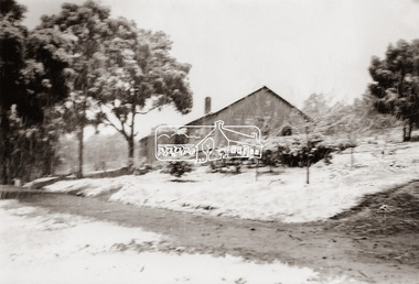
Photograph, The Stokes family home blanketed with snow, corner Nyora and Eucalyptus roads, Eltham, winter 1951, 1951
... bounded by Pitt Street, Eucalyptus Road and Wattle Grove) and they got talking over their common interest. Arthur put Frank up for the night and pointed out the land, part of Crown Allotment 15, Section 5, Parish of Nillumbik (CA15) somewhat diagonally opposite Bird Orchard. Frank bought the land and for the next two years would travel...bounded by Pitt Street, Eucalyptus Road and Wattle Grove) and they got talking over their common interest. Arthur put Frank up for the night and pointed out the land, part of Crown Allotment 15, Section 5, Parish of Nillumbik (CA15) somewhat diagonally opposite Bird Orchard. Frank bought the land and for the next two years would travel ...Taken from outside the family home on the southest corner of the intersection of Nyora Road and Pitt Street with Eucalyptus Road. Frank Stokes first traveled to the district by train in 1944 to find land with the intention to establish an orchard. By chance he met Arthur Bird of Bird Orchard (bounded by Pitt Street, Eucalyptus Road and Wattle Grove) and they got talking over their common interest. Arthur put Frank up for the night and pointed out the land, part of Crown Allotment 15, Section 5, Parish of Nillumbik (CA15) somewhat diagonally opposite Bird Orchard. Frank bought the land and for the next two years would travel by train from Melbourne to Eltham every weekend establishing Stokes Orchard and building a home for his family, which they eventually moved into in 1946. In the mid 1970s the Shire of Eltham divided the orchard up into numerous rate-able parcel lots, which became affordable for Frank. As a consequence Stokes Orchard was turned into a housing development by Macquarie Builders and marketed as the Stokes Orchard Estate in two stages; Stage 1 encompassing Scarlet Ash Court, Ironbark Close and Peppermint Grove bounded by Nyora and Eucalyptus roads c.1976 and Stage 2 encompassing Stokes Place, Orchard Way, The Crest and The Lookout bound by Nyora and Diosma roads c.1979. The development of Orchard Way, The Crest and The Lookout did not proceed as planned due to the lack of the sewer along Diosma Road and so many of the proposed lots were incorporated into five-acre parcels instead.Representative of the orchard growing areas of Eltham. One of the rare times it has snowed in ElthamDigital file only - Digitised by EDHS from a scrapbook (containing commercially printed photos of digital scans) on loan from Beryl Bradbury (nee Stokes), daughter of Frank Stokes.1951, beryl bradbury (nee stokes) collection, eltham, eucalyptus road, nyora road, snow, stokes family home -
 Eltham District Historical Society Inc
Photograph, The Stokes family home and orchard blanketed with snow, corner Nyora and Eucalyptus roads, Eltham, Winter 1951, 1951
... bounded by Pitt Street, Eucalyptus Road and Wattle Grove) and they got talking over their common interest. Arthur put Frank up for the night and pointed out the land, part of Crown Allotment 15, Section 5, Parish of Nillumbik (CA15) somewhat diagonally opposite Bird Orchard. Frank bought the land and for the next two years would travel...bounded by Pitt Street, Eucalyptus Road and Wattle Grove) and they got talking over their common interest. Arthur put Frank up for the night and pointed out the land, part of Crown Allotment 15, Section 5, Parish of Nillumbik (CA15) somewhat diagonally opposite Bird Orchard. Frank bought the land and for the next two years would travel ...Taken from outside the family home on the southest corner of the intersection of Nyora Road and Pitt Street with Eucalyptus Road. Frank Stokes first traveled to the district by train in 1944 to find land with the intention to establish an orchard. By chance he met Arthur Bird of Bird Orchard (bounded by Pitt Street, Eucalyptus Road and Wattle Grove) and they got talking over their common interest. Arthur put Frank up for the night and pointed out the land, part of Crown Allotment 15, Section 5, Parish of Nillumbik (CA15) somewhat diagonally opposite Bird Orchard. Frank bought the land and for the next two years would travel by train from Melbourne to Eltham every weekend establishing Stokes Orchard and building a home for his family, which they eventually moved into in 1946. Marjorie North remembered well the winter of 1951, when she took children, including son John together with the Shallard and Squire children “in the Austin A40 up the Main Rd., Eltham to farmer Bell’s property alongside the Eltham College. They were able to make a snow man and throw snowballs. (Diamond Valley News, August 5, 1986.p.42) In the mid 1970s the Shire of Eltham divided the orchard up into numerous rate-able parcel lots, which became affordable for Frank. As a consequence Stokes Orchard was turned into a housing development by Macquarie Builders and marketed as the Stokes Orchard Estate in two stages; Stage 1 encompassing Scarlet Ash Court, Ironbark Close and Peppermint Grove bounded by Nyora and Eucalyptus roads c.1976 and Stage 2 encompassing Stokes Place, Orchard Way, The Crest and The Lookout bound by Nyora and Diosma roads c.1979. The development of Orchard Way, The Crest and The Lookout did not proceed as planned due to the lack of the sewer along Diosma Road and so many of the proposed lots were incorporated into five-acre parcels instead.Representative of the orchard growing areas of Eltham. One of the rare times it has snowed in Eltham.Digital file only - Digitised by EDHS from a scrapbook (containing commercially printed photos of digital scans) on loan from Beryl Bradbury (nee Stokes), daughter of Frank Stokes.1951, beryl bradbury (nee stokes) collection, eltham, nyora road, eucalyptus road, snow, stokes family home -
 Eltham District Historical Society Inc
Photograph, The first houses in construction on the new Stokes Orchard Estate, July 1976, July 1976
... bounded by Pitt Street, Eucalyptus Road and Wattle Grove) and they got talking over their common interest. Arthur put Frank up for the night and pointed out the land, part of Crown Allotment 15, Section 5, Parish of Nillumbik (CA15) somewhat diagonally opposite Bird Orchard. Frank bought the land and for the next two years would travel...bounded by Pitt Street, Eucalyptus Road and Wattle Grove) and they got talking over their common interest. Arthur put Frank up for the night and pointed out the land, part of Crown Allotment 15, Section 5, Parish of Nillumbik (CA15) somewhat diagonally opposite Bird Orchard. Frank bought the land and for the next two years would travel ...Viewed from near the Stokes family home at 1 Nyora Road looking northeast across Ironbark Close to Scarlet Ash Court with Peppermint Grove in the distance. Frank Stokes first traveled to the district by train in 1944 to find land with the intention to establish an orchard. By chance he met Arthur Bird of Bird Orchard (bounded by Pitt Street, Eucalyptus Road and Wattle Grove) and they got talking over their common interest. Arthur put Frank up for the night and pointed out the land, part of Crown Allotment 15, Section 5, Parish of Nillumbik (CA15) somewhat diagonally opposite Bird Orchard. Frank bought the land and for the next two years would travel by train from Melbourne to Eltham every weekend establishing Stokes Orchard and building a home for his family, which they eventually moved into in 1946. In the mid 1970s the Shire of Eltham divided the orchard up into numerous rate-able parcel lots, which became affordable for Frank. As a consequence Stokes Orchard was turned into a housing development by Macquarie Builders and marketed as the Stokes Orchard Estate in two stages; Stage 1 encompassing Scarlet Ash Court, Ironbark Close and Peppermint Grove bounded by Nyora and Eucalyptus roads c.1976 and Stage 2 encompassing Stokes Place, Orchard Way, The Crest and The Lookout bound by Nyora and Diosma roads c.1979. The development of Orchard Way, The Crest and The Lookout did not proceed as planned due to the lack of the sewer along Diosma Road and so many of the proposed lots were incorporated into five-acre parcels instead.Housing development in Eltham as an extension to the Woodridge EstateDigital file only - Digitised by EDHS from a scrapbook (containing commercially printed photos of digital scans) on loan from Beryl Bradbury (nee Stokes), daughter of Frank Stokes.1976-07, beryl bradbury (nee stokes) collection, building construction, ironbark close, nyora road, peppermint grove, scarlet ash court, stokes orchard estate, houses -
 Eltham District Historical Society Inc
Photograph, Looking south towards Nyora Road, Eltham, 1977, 1977
... bounded by Pitt Street, Eucalyptus Road and Wattle Grove) and they got talking over their common interest. Arthur put Frank up for the night and pointed out the land, part of Crown Allotment 15, Section 5, Parish of Nillumbik (CA15) somewhat diagonally opposite Bird Orchard. Frank bought the land and for the next two years would travel...bounded by Pitt Street, Eucalyptus Road and Wattle Grove) and they got talking over their common interest. Arthur put Frank up for the night and pointed out the land, part of Crown Allotment 15, Section 5, Parish of Nillumbik (CA15) somewhat diagonally opposite Bird Orchard. Frank bought the land and for the next two years would travel ...Viewed from near the end of Stokes Place where the linear reserve now runs between 8 and 9 Stokes Place just visible through trees in foreground, 24 Nyora with red roof is the first house in middle of view. Frank Stokes first traveled to the district by train in 1944 to find land with the intention to establish an orchard. By chance he met Arthur Bird of Bird Orchard (bounded by Pitt Street, Eucalyptus Road and Wattle Grove) and they got talking over their common interest. Arthur put Frank up for the night and pointed out the land, part of Crown Allotment 15, Section 5, Parish of Nillumbik (CA15) somewhat diagonally opposite Bird Orchard. Frank bought the land and for the next two years would travel by train from Melbourne to Eltham every weekend establishing Stokes Orchard and building a home for his family, which they eventually moved into in 1946. In the mid 1970s the Shire of Eltham divided the orchard up into numerous rate-able parcel lots, which became affordable for Frank. As a consequence Stokes Orchard was turned into a housing development by Macquarie Builders and marketed as the Stokes Orchard Estate in two stages; Stage 1 encompassing Scarlet Ash Court, Ironbark Close and Peppermint Grove bounded by Nyora and Eucalyptus roads c.1976 and Stage 2 encompassing Stokes Place, Orchard Way, The Crest and The Lookout bound by Nyora and Diosma roads c.1979. The development of Orchard Way, The Crest and The Lookout did not proceed as planned due to the lack of the sewer along Diosma Road and so many of the proposed lots were incorporated into five-acre parcels instead.Housing development in Eltham as an extension to the Woodridge EstateDigital file only - Digitised by EDHS from a scrapbook (containing commercially printed photos of digital scans) on loan from Beryl Bradbury (nee Stokes), daughter of Frank Stokes.1977, beryl bradbury (nee stokes) collection, nyora road, stokes orchard estate, stokes place -
 Eltham District Historical Society Inc
Photograph, Stokes Place, Eltham, July 1977, July 1977
... bounded by Pitt Street, Eucalyptus Road and Wattle Grove) and they got talking over their common interest. Arthur put Frank up for the night and pointed out the land, part of Crown Allotment 15, Section 5, Parish of Nillumbik (CA15) somewhat diagonally opposite Bird Orchard. Frank bought the land and for the next two years would travel...bounded by Pitt Street, Eucalyptus Road and Wattle Grove) and they got talking over their common interest. Arthur put Frank up for the night and pointed out the land, part of Crown Allotment 15, Section 5, Parish of Nillumbik (CA15) somewhat diagonally opposite Bird Orchard. Frank bought the land and for the next two years would travel ...Viewed from near the end of Stokes Place where the linear reserve now runs between 8 and 9 Stokes Place looking slightly east of south towards Nyora Road. The new Christian Church on Nyora now the Baptist Church visible in middle view. Frank Stokes first traveled to the district by train in 1944 to find land with the intention to establish an orchard. By chance he met Arthur Bird of Bird Orchard (bounded by Pitt Street, Eucalyptus Road and Wattle Grove) and they got talking over their common interest. Arthur put Frank up for the night and pointed out the land, part of Crown Allotment 15, Section 5, Parish of Nillumbik (CA15) somewhat diagonally opposite Bird Orchard. Frank bought the land and for the next two years would travel by train from Melbourne to Eltham every weekend establishing Stokes Orchard and building a home for his family, which they eventually moved into in 1946. In the mid 1970s the Shire of Eltham divided the orchard up into numerous rate-able parcel lots, which became affordable for Frank. As a consequence Stokes Orchard was turned into a housing development by Macquarie Builders and marketed as the Stokes Orchard Estate in two stages; Stage 1 encompassing Scarlet Ash Court, Ironbark Close and Peppermint Grove bounded by Nyora and Eucalyptus roads c.1976 and Stage 2 encompassing Stokes Place, Orchard Way, The Crest and The Lookout bound by Nyora and Diosma roads c.1979. The development of Orchard Way, The Crest and The Lookout did not proceed as planned due to the lack of the sewer along Diosma Road and so many of the proposed lots were incorporated into five-acre parcels instead.Housing development in Eltham as an extension to the Woodridge EstateDigital file only - Digitised by EDHS from a scrapbook (containing commercially printed photos of digital scans) on loan from Beryl Bradbury (nee Stokes), daughter of Frank Stokes.1977-07, beryl bradbury (nee stokes) collection, eltham, eltham christian church, stokes orchard estate, stokes place