
Showing 9 items matching "vale park reserve"
-
 Federation University Historical Collection
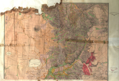
Map, Ballarat Goldfield, c1898
... ...vale park reserve...The map indicates the position of Lake Wendouree, Township of Warrenheip, Ballarat East, Industrial School Reserve, Winters Swamp, Police Paddock, Wyndholm Premptive Right (Salton and Waldie), Black Hill, Vale Park Reserve, Pennyweight Hill, Little Bendigo, Black Swamp Lead, monte Christo Reef, Chinaman's Gully, Miners Rest, Pincotts Dam, Northumberland Gully. ...The map indicates the position of Lake Wendouree, Township of Warrenheip, Ballarat East, Industrial School Reserve, Winters Swamp, Police Paddock, Wyndholm Premptive Right (Salton and Waldie), Black Hill, Vale Park Reserve, Pennyweight Hill, Little Bendigo, Black Swamp Lead, monte Christo Reef, Chinaman's Gully, Miners Rest, Pincotts Dam, Northumberland Gully. ...This map shows geological features, suggests the last basalt flow, and includes alotments and names of Mining Companies. Although this map has no date on it the Ballarat Industrial School is used for dating purposed. The Ballarat Industrial School ran from 1869-1879, but the term Ballarat Industrial School Reserve was still in use in 1898 and possibly beyond.Geological Map of Ballarat with 3 holes in the left hand side. The map indicates the position of Lake Wendouree, Township of Warrenheip, Ballarat East, Industrial School Reserve, Winters Swamp, Police Paddock, Wyndholm Premptive Right (Salton and Waldie), Black Hill, Vale Park Reserve, Pennyweight Hill, Little Bendigo, Black Swamp Lead, monte Christo Reef, Chinaman's Gully, Miners Rest, Pincotts Dam, Northumberland Gully. It also show the following goldmining companies: City of Ballarat, Kohinor, Hand and Band, Great North West, Northern Junction, Kneeshaw, Rossers Freehold, Silurial.ballarat, warrenheip, lake wendouree, ballarat east, winters swamp, winter swamp, wyndholm premptive right, cemetery, vale park reserve, little bendigo, kneeshaw co., industrial school reserve, kirks dam, pincotts dam, black hill, wombat hill, dead horse gully, miners rest, mt rowan, salton and waldie, rose hill co, great north west no 1, rose's freehold co, hand and band co, police reserve, police paddock, mount rowan, ballarat industrial school reserve, market reserve, winter's swamp, kneeshar co, monte cristo line of reef, chinaman's gully or black snake, milkmaid's gully, ballarat gold field, bakery hil lead, old gravel pits lead, golden point lead, eureka lead, miner's rest, yarrowee creek, leigh creek, black swamp lead, yorkshire reef, nil desperandum reef, cockatoo lead, hit or miss gully, herbert werner frederick de nully, pennyweight hill, esmond's lead, ash's lead, nightingale lead, john bull gully, gladstone reef, whitehorse reef, petticoat creek, pincott's dam, frenchman's gully, tim's crushing plant, jenkin's gully, california gully, drake's creek, sulton and waldie, ballarat undustrial school, ballarat & mariborough railway -
 Federation University Historical Collection
Book, Historic Sites Survey: North Central Study Area, 1979, 1979
... park, ballarat...muont holled smith...ballaarat old cemetery planting...eastern oval...ballarat east botanical gardens...ballarat east town hall gardens...eureka stockade reserve...ballarat observatory plantings...yarrowee creek plantings...yarrowee bluestone channels...ballarat woollen mill...band and albion mullock heap...black hill plantings...yarrowee creek channels...canadian creek channel...specimen vale...The North Central Study Area included the Shires of Avoca, Bet Bet, east Loddon, Goulburn, Untly, Kara Kara, Korong, Maldon, Marong, Metcalfe, McIvor, Newstead, Strathfieldsaye, Stawell, Talbot, Clunes, Tullaroop and Waranga. castlemaine mount alexander goldfield maldon percydale warrenmang moliagul tarnagulla stuart mill the whipstick whroo rushworth graytown ironbark forest st arnoaud new bendigo landsborough inglewood kurting wedderburn wehla kooroora langham flat mcintyre rheola diamond hill fosterville coliban water works green gully newstead muckleford forest costerfield graytown bailieston waranga irrigaiton system eucalyptus distillery mia mia bridge korokubeal township researce concegella slate quarry chewton fryerstown kingower timor talbot majorca carisbroook clunes st arnaud taradale icomos dunolly limestone castlemaine slate quarry harcourt granite taradale railway viaduct loddon united waterworks trust gouldburn weir carisbrook lock-up history of tree planting in streets history of public reserves r.u. nicholls nurseryman thomas lang francis moss ballarat botanical gardens ballarat school of mines botanical gardens lake wendouree victoria park, ballarat muont holled smith ballaarat old cemetery planting eastern oval ballarat east botanical gardens ballarat east town hall gardens eureka stockade reserve ballarat observatory plantings yarrowee creek plantings yarrowee bluestone channels ballarat woollen mill band and albion mullock heap black hill plantings yarrowee creek channels canadian creek channel specimen vale channel poverty point reserve union jack reserve buninyong imperial mine, buninyong victoria street plantings bridge mall sturt street gardens ballarat avenue of honour plantings white flat oval plantings camp street elms burnt creek 153 page book with white plastic binding. ...The North Central Study Area included the Shires of Avoca, Bet Bet, east Loddon, Goulburn, Untly, Kara Kara, Korong, Maldon, Marong, Metcalfe, McIvor, Newstead, Strathfieldsaye, Stawell, Talbot, Clunes, Tullaroop and Waranga. 153 page book with white plastic binding. It is an historic sites survey for the North Central Study Area commissioned by the Land Conservation Council, the Ministry for COnservation and the Australian Heritage Commission. castlemaine, mount alexander goldfield, maldon, percydale, warrenmang, moliagul, tarnagulla, stuart mill, the whipstick, whroo, rushworth, graytown ironbark forest, st arnoaud, new bendigo, landsborough, inglewood, kurting, wedderburn, wehla, kooroora, langham flat, mcintyre, rheola, diamond hill, fosterville, coliban water works, green gully, newstead, muckleford forest, costerfield, graytown, bailieston, waranga irrigaiton system, eucalyptus distillery, mia mia bridge, korokubeal township researce, concegella slate quarry, chewton, fryerstown, kingower, timor, talbot, majorca, carisbroook, clunes, st arnaud, taradale, icomos, dunolly, limestone, castlemaine slate quarry, harcourt granite, taradale railway viaduct, loddon united waterworks trust, gouldburn weir, carisbrook lock-up, history of tree planting in streets, history of public reserves, r.u. nicholls nurseryman, thomas lang, francis moss, ballarat botanical gardens, ballarat school of mines botanical gardens, lake wendouree, victoria park, ballarat, muont holled smith, ballaarat old cemetery planting, eastern oval, ballarat east botanical gardens, ballarat east town hall gardens, eureka stockade reserve, ballarat observatory plantings, yarrowee creek plantings, yarrowee bluestone channels, ballarat woollen mill, band and albion mullock heap, black hill plantings, yarrowee creek channels, canadian creek channel, specimen vale channel, poverty point reserve, union jack reserve buninyong, imperial mine, buninyong, victoria street plantings, bridge mall, sturt street gardens, ballarat avenue of honour plantings, white flat oval plantings, camp street, elms, burnt creek -
Marysville & District Historical Society
THE TRIANGLE NEWS-VOL 40 NO 19-MAY 24 2013
... reserve...working bee...intrepid triangle bushwalkers...the committee of management of the gallipoli park precinct...marysville community market...creative triangle...fire services levy now part of rates notices...church notices...triangle community dinner...el kanah village...biggest morning tea a success...vale...marysville victoria australia $28 million vibe hotel marsyville breaks ground deputy premier and minister for regional & rural development peter ryan what's on when in may and june buxton recreational reserve working bee intrepid triangle bushwalkers the committee of management of the gallipoli park precinct marysville community market creative triangle fire services levy now part of rates notices church notices triangle community dinner el kanah village biggest morning tea a success vale brian moore murrindindi shire council payment of rate installment position vacant mayor's chair marysville primary school mother's day raffle advertisements buxton fire brigade anna's mobile patchwork quilt shop open capital works program supports existing infrastructure villains storm home to first ever away victory staff wanted black spur inn greenlands guesthouse open by lachlan fraser building our future draft council plan released for comment emotions anonymous international buxton hotel real estate marysville golf report snowgum hillary challenge comes to marysville last quarter assault gets villains home free mulch loading triangle community dance group marysville villains sponsors and members lunch randy the puppet is back for lunch draft council plan and budget have your say melbourne international comedy festival marysville & district lions club road maintenance and construction works free information session council delivers conservative draft budget yarra valley div 1 game in marysville a success THE TRIANGLE NEWS-VOL 40 NO 19-MAY 24 2013 ...marysville, victoria, australia, $28 million vibe hotel marsyville breaks ground, deputy premier and minister for regional & rural development, peter ryan, what's on when in may and june, buxton recreational reserve, working bee, intrepid triangle bushwalkers, the committee of management of the gallipoli park precinct, marysville community market, creative triangle, fire services levy now part of rates notices, church notices, triangle community dinner, el kanah village, biggest morning tea a success, vale brian moore, murrindindi shire council, payment of rate installment, position vacant, mayor's chair, marysville primary school mother's day raffle, advertisements, buxton fire brigade, anna's mobile patchwork quilt shop open, capital works program supports existing infrastructure, villains storm home to first ever away victory, staff wanted black spur inn, greenlands guesthouse open by lachlan fraser, building our future draft council plan released for comment, emotions anonymous international, buxton hotel, real estate, marysville golf report, snowgum hillary challenge comes to marysville, last quarter assault gets villains home, free mulch loading, triangle community dance group, marysville villains sponsors and members lunch, randy the puppet is back for lunch, draft council plan and budget have your say, melbourne international comedy festival, marysville & district lions club, road maintenance and construction works free information session, council delivers conservative draft budget, yarra valley div 1 game in marysville a success -
Marysville & District Historical Society
THE TRIANGLE NEWS-VOL 41 NO 40-OCTOBER 17 2014
... park precinct...marysville community market...creative triangle...marysville art show 2014...community centre cup weekend...church notices...mayor's chair cr margaret rae...murrindindi shire council...local couple complete journey...$4000 raised for cystic fibrosis vic...street stall christ church marysville...emotions anonymous international meeting...marysville & triangle community men's shed...buxton recreation reserve committee...community working bee...vale...marysville victoria australia australian wine show business breakfast black spur inn what's on when in october the committee of management of the gallipoli park precinct marysville community market creative triangle marysville art show 2014 community centre cup weekend church notices mayor's chair cr margaret rae murrindindi shire council local couple complete journey $4000 raised for cystic fibrosis vic street stall christ church marysville emotions anonymous international meeting marysville & triangle community men's shed buxton recreation reserve committee community working bee vale brett pearce pink lunch pink ribbon day national breast cancer foundation marysville & district football & netball club agm marysville triangle real estate dalton fiske foundation advertisements burglary at buxton pub community light the night tender dinner and adventurer speaker men's shed marysville community golf & bowls club alexandra audit committee funding advocacy where to from here auction at buxton hall council targets elm leaf beetle hume joint kerbside tender THE TRIANGLE NEWS-VOL 41 NO 40-OCTOBER 17 2014 ...marysville, victoria, australia, australian wine show business breakfast, black spur inn, what's on when in october, the committee of management of the gallipoli park precinct, marysville community market, creative triangle, marysville art show 2014, community centre cup weekend, church notices, mayor's chair cr margaret rae, murrindindi shire council, local couple complete journey, $4000 raised for cystic fibrosis vic, street stall christ church marysville, emotions anonymous international meeting, marysville & triangle community men's shed, buxton recreation reserve committee, community working bee, vale brett pearce, pink lunch, pink ribbon day, national breast cancer foundation, marysville & district football & netball club agm, marysville triangle real estate, dalton fiske foundation, advertisements, burglary at buxton pub, community light the night, tender, dinner and adventurer speaker men's shed, marysville community golf & bowls club, alexandra audit committee, funding advocacy where to from here, auction at buxton hall, council targets elm leaf beetle, hume joint kerbside tender -
Glen Eira Historical Society
Book - CAULFIELD CENTENARY 1957
... Park... Bambra Road... Riley Reserve... Playgrounds... Town Hall... Maternal and child health centres... Truganini Road... Grange Road... Senior Citizens centre... Barkley Sir Henry... Moore David... Handasyde Gilbert... Caulfield School Room... Harris G.W.... Semple John... Dempsey William... Brooks W.A.... Wilson Thomas... Lyall William... Murrum Murrumbeen lifestyle... ‘Greenmeadows’ House... Lempriere family... Aboriginal culture... ‘Rippon Lea’ House... Caulfield John... ‘Slaney’s’ Home... Alma Road... Paddy’s Swamp... Racecourse Hotel... Caulfield Technical College... Bevan Mr.... ‘Grosmont’... Hart John... Railways... Mansions... ‘Rosecraddock’... Langdon H. J.... Caulfield Cup... ‘Crotonhurst’... Webb Judge... ‘Kilwinning’... Service James... Ricketson Henry... ‘Glen Eira’... House names... Garden Vale...Park Bambra Road Riley Reserve Playgrounds Town Hall Maternal and child health centres Truganini Road Grange Road Senior Citizens centre Barkley Sir Henry Moore David Handasyde Gilbert Caulfield School Room Harris G.W. Semple John Dempsey William Brooks W.A. Wilson Thomas Lyall William Murrum Murrumbeen lifestyle ‘Greenmeadows’ House Lempriere family Aboriginal culture ‘Rippon Lea’ House Caulfield John ‘Slaney’s’ Home Alma Road Paddy’s Swamp Racecourse Hotel Caulfield Technical College Bevan Mr. ‘Grosmont’ Hart John Railways Mansions ‘Rosecraddock’ Langdon H. J. Caulfield Cup ‘Crotonhurst’ Webb Judge ‘Kilwinning’ Service James Ricketson Henry ‘Glen Eira’ House names Garden Vale ...This file contains four items 1/Two copies of a twenty-four page booklet titled CITY OF CAULFIELD CENTENARY 1857-1957, created by the Caulfield City Council and printed by Peter Isaacson Pty Limited, Melbourne. The booklet details important aspects of Caulfield’s history including council procedures, the Caulfield Road District Proclamation, the first election and a summary of 100 years of local government with a description of the present Caulfield in 1957. The booklet also includes several pictures of various Caulfield landmarks and people including one of Caulfield City Councillors (11 men and 1 woman). Also one photocopied version of this booklet. 2/Eleven pages of typed notes for the City of Caulfield Centenary booklet. All notes are undated and incomplete. Two pages titled NOTES on THE HISTORY and PROGRESS OF THE CITY OF CAULFIELD, author unknown. Three and a half pages titled THE STRUCTURE OF LOCAL GOVERNMENT IN VICTORIA, author unknown. Five pages titled 100 YEARS OF LOCAL GOVERNMENT – EARLY CAULFIELD, by Mrs A. P. Bell. 3/A typed letter to Miss V. Webb-Langdon from the Town Clerk H.G. Nelson, acknowledging her contribution to historical details for the Caulfield Council’s Centenary booklet, dated 24/12/1957. 4/A handwritten letter and a handwritten note regarding the acquisition of notes for the Caulfield Centenary booklet. The letter is dated 03/08/2006 and the note is dated 09/02/2007.city of caulfield centenary, caulfield road district, sinclair a.j.g., city hall, war memorials, gamble h.a., machin l.r., bunny f.c.d., caulfield park, koornang reserve, parton e.m., sims h.e., thomson w.r., gunn e.e., yorston j.s., wallace g.e. mrs, green w.c., jenner e.r., ward boundaries, dandenong road, queens avenue, normanby road, station street, bond street, glen eira road, orrong road, poath road, north road, booran road, nepean highway, glen huntly road, glenhuntly road, inkerman road, hotham street, nelson h.g., fullard w.r., mackley g.j., ellis k.i, crosbie m.r., nutting b.i., body j.h., pritchard r.j., guildford l.t.g., lund l.m., street h.c., reynolds a.w., elections , political processes, local government, springthorpe reserve, greenmeadows gardens, business and finance, roads and streets, caulfield racecourse, east caulfield reserve, mackinnon reserve, hawthorn road, balaclava road, murrumbeena road, lempriere avenue, victoria street, koornang road, lord reserve, lyons street, murrumbeena reserve, kangaroo road, ormond park, beatty crescent, foch street, packer reserve, oakleigh road, leila road, prices park, bambra road, riley reserve, playgrounds, town hall, maternal and child health centres, truganini road, grange road, senior citizens centre, barkley sir henry, moore david, handasyde gilbert, caulfield school room, harris g.w., semple john, dempsey william, brooks w.a., wilson thomas, lyall william, murrum murrumbeen lifestyle, ‘greenmeadows’ house, lempriere family, aboriginal culture, ‘rippon lea’ house, caulfield john, ‘slaney’s’ home, alma road, paddy’s swamp, racecourse hotel, caulfield technical college, bevan mr., ‘grosmont’, hart john, railways, mansions, ‘rosecraddock’, langdon h. j., caulfield cup, ‘crotonhurst’, webb judge, ‘kilwinning’, service james, ricketson henry, ‘glen eira’, house names, garden vale, ross william murray, ‘ross’s folly’, outer circle railway, caulfield grammar school, davies j. henry, lagdon william, grimwade f.s., loyd charles du plan, hope george, ‘airdrie’, kooyong hill, market gardens, dairies, lady talbot milk supply, jenner family, o’niell college, presentation sisters, glenferrie road, grimwade frederick sheppard, grimwade alice, ‘harlston’, grimwade house, ‘saint aubin’s’, ‘st. aubin’s’, ‘caulfield hall’, caulfield john p.t., st georges road, caulfield military hospital, nursing homes, health establishments, dover street, sports and recreations, rosanna street, ‘cantala’, health services, parks and reserves, community services, town planning, local government finance, local officials and employees -
Glen Eira Historical Society
Document - KOOYONG ROAD, 75, CAULFIELD NORTH
... Park... Caulfield Council... North Caulfield... Campton E.J. (Brigadier)... Walters W.R. Mrs.... Calder G.K.... Calder G.K. Mrs.... Mahon J. (Chief Superintendent)... City Hall... Balaclava Road... Hawthorn Road... Glen Eira Road... Hartley Avenue... Kooyong Road... Caulfield Racecourse... Caulfield Town Hall... Alma Road... Red Cheques Cab Company... Army Headquarters Printing Press... Searchlight Company... Amenities Store... Armoured Replacement Unit... First Base Printing Company R.A.A.O.C.... Garden Vale... Caulfield Railway Station... Paddy’s Swamp... Great Dandenong Road... Glen Ferrie Road... Dandenong Road... East Caulfield Reserve...Park Caulfield Council North Caulfield Campton E.J. (Brigadier) Walters W.R. Mrs. Calder G.K. Calder G.K. Mrs. Mahon J. (Chief Superintendent) City Hall Balaclava Road Hawthorn Road Glen Eira Road Hartley Avenue Kooyong Road Caulfield Racecourse Caulfield Town Hall Alma Road Red Cheques Cab Company Army Headquarters Printing Press Searchlight Company Amenities Store Armoured Replacement Unit First Base Printing Company R.A.A.O.C. Garden Vale Caulfield Railway Station Paddy’s Swamp Great Dandenong Road Glen Ferrie Road Dandenong Road East Caulfield Reserve ...Two copies of a pamphlet for the ceremony of the Third Ordnance Services Unit ‘Exercising the Right of the Freedom of Entry to the City of Caulfield’ held on 23/10/1983. The pamphlet includes a brief history of the unit’s association with the City of Caulfield, a list of individuals holding posts within the Unit, text of the scroll conferring the Freedom of Entry on the Unit, a program of the ceremony, a brief history of the Royal Australian Army Ordnance Corps including the Unit’s use of 75 Kooyong Road as their premises, a brief history of the City of Caulfield from 1937-postwar years, and an explanation of the tradition of conferring Freedom of Entry to a city. The pamphlet includes also: 1/A black and white photograph (47x35mm) of the Mayor of Caulfield, W.R. Walters, undated and unattributed. 2/A black and white photograph (81x69mm) of Major A.G. Storen, Commanding Officer of the Third Ordnance Services Unit, undated and unattributed. 3/A color photograph (88x84mm) of the Sovereign’s Banner, undated and unattributed. 4/A black and white copy (137x87mm) of the scroll conferring Freedom of Entry into the City of Caulfield, which was seated August 4 1978. 5/A color illustration (30x32mm) of the City of Caulfield Coat of Arms. 6/A color illustration (40x32mm) of the Third Ordnance Services Unit, Royal Australian Army Ordnance Corps Coat of Arms. 7/A black and white illustration (21x24mm) of the city of Caulfield Coat of Arms. 8/A black and white illustration (19x14mm) of the City of Caulfield badge. 9/A black and white illustration (22x31mm) of the City of Caulfield banner.walters w.r., storen a.g. major, finning d.j. captain, hately p.g. major, davidson j. (captain), swendson r. (second lieutenant), caulfield, city of caulfield, australian army, the third ordnance services unit royal australian army ordnance corps, caulfield park, caulfield council, north caulfield, campton e.j. (brigadier), walters w.r. mrs., calder g.k., calder g.k. mrs., mahon j. (chief superintendent), city hall, balaclava road, hawthorn road, glen eira road, hartley avenue, kooyong road, caulfield racecourse, caulfield town hall, alma road, red cheques cab company, army headquarters printing press, searchlight company, amenities store, armoured replacement unit, first base printing company r.a.a.o.c., garden vale, caulfield railway station, paddy’s swamp, great dandenong road, glen ferrie road, dandenong road, east caulfield reserve, caulfield military hospital, ‘glen eira’, town hall, ‘war office’, caulfield district road board, shire of caulfield, caulfield recruiting committee for volunteers, city repatriation committee, red cross emergency service, women’s national service, mayor’s patriotic fund, promotions committee for war savings certificates, war savings group scheme, ‘the gazette’, air raid precautions committee, orrong road, armed forces, world war 1939-1945, local government, parades and processions, military reserves, world war 1914-1918, councillors, events and activities, historic events, official events, caulfield john, wyne agar, murphy (mayor), hale p., ison (captain), fisher andrew, morris t.w. (mayor) -
Glen Eira Historical Society
Document - KOOYONG ROAD, 75, CAULFIELD NORTH
... Park... North Caulfield... City of Caulfield... City Hall... Balaclava Road... Hawthorn Road... Glen Eira Road... Hartley Avenue... Caulfield Racecourse... Caulfield Town Hall... Alma Road... Orrong Road... Garden Vale... Caulfield Railway Station... Paddy’s Swamp... Great Dandenong Road... Glen Ferrie Road... Dandenong Road... East Caulfield Reserve...(Mayor) Caulfield Kooyong Road Caulfield Park North Caulfield City of Caulfield City Hall Balaclava Road Hawthorn Road Glen Eira Road Hartley Avenue Caulfield Racecourse Caulfield Town Hall Alma Road Orrong Road Garden Vale Caulfield Railway Station Paddy’s Swamp Great Dandenong Road Glen Ferrie Road Dandenong Road East Caulfield Reserve Caulfield Military Hospital ‘Glen Eira’ Town Hall ‘War Office’ Red Chequer Cab Company Caulfield Council Third Ordnance Services Unit Royal Australian Army Ordnance Corps Australian Army Army Headquarters Printing Press Searchlight Company Amenities Store Armoured Replacement Unit First Base Printing Company R.A.A.O.C. ...Three copies of a pamphlet for the ceremony of the Third Ordnance Services Unit ‘Exercising the Right of the Freedom of Entry to the City of Caulfield’, held on 13/07/1986. The pamphlet includes a brief history of the Unit’s association with the City of Caulfield, a list of individuals holding posts within the unit, text of the scroll conferring the Freedom of Entry on the Unit, a program of the ceremony, a brief history of the Royal Australian Army Ordnance Corps, including the Unit’s use of 75 Kooyong Road as their premises, a brief history of the city of Caulfield and an explanation of the tradition of conferring Freedom of Entry to a city. The pamphlet includes also: 1/A black and white photograph (61x66mm) of the Mayor of Caulfield, Maxwell Blair, undated and unattributed. 2/A black and white photograph (70x51mm) of Major P.G. Hateley, Commanding Officer of the Third Ordnance Services Unit, undated and unattributed. 3/A black and white photograph (91x90mm) of the Sovereign’s Banner, undated and unattributed. 4/A black and white copy (137-87) of the scroll conferring Freedom of Entry into the City of Caulfield which was seated August 4 1978. 5/A color illustration (30x32mm) of the City of Caulfield Coat of Arms. 6/A colour illustration (40x32mm) of the Third Ordnance Services Unit, Royal Australian Army Ordnance Corps Coat of Arms. 7/A black and white illustration (21x24mm) of the City of Caulfield Coat of Arms. 8/A black and white illustration (19x19mm) of the City of Caulfield badge. 9/A black and white illustration (22x31mm) of the City of Caulfield banner.blair maxwell (mayor), hateley p.g. (major), finning d.j. (captain), lowe g. (captain), barker l.a. (lieutenant), blair mrs., aylen d.r., aylan d.r. mrs., goltz m.h., compton e.j. (brigadier), goltz m.h. (chief superintendant), caulfield john, wynne agar, murphy (mayor), hate p., ison (captain), fisher andrew, morris t.w. (mayor), caulfield, kooyong road, caulfield park, north caulfield, city of caulfield, city hall, balaclava road, hawthorn road, glen eira road, hartley avenue, caulfield racecourse, caulfield town hall, alma road, orrong road, garden vale, caulfield railway station, paddy’s swamp, great dandenong road, glen ferrie road, dandenong road, east caulfield reserve, caulfield military hospital, ‘glen eira’, town hall, ‘war office’, red chequer cab company, caulfield council, third ordnance services unit royal australian army ordnance corps, australian army, army headquarters printing press, searchlight company, amenities store, armoured replacement unit, first base printing company r.a.a.o.c., caulfield district road board, shire of caulfield, caulfield recruiting committee for volunteers, city repatriation committee, red cross emergency service, women’s national service, mayor’s patriotic fund, promotions committee for war savings certificates, war savings group scheme, ‘the gazette’, air raid precautions committee, armed forces, world war 1939-1945, local government, parades and processions, military reserves, world war 1914-1918, councillors, events and activities, historic events, official events -
 Eltham District Historical Society Inc
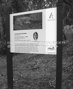
Photograph - Digital Photograph, Alan King, Sign: Clara Southern, Heidelberg School Artists Trail, Main Road, Research, 2008
... Vale, daughter of politician William, lived in Diamond Creek. With Jane Price they feature on the Heidelberg School Artists Trail, part of which runs through Nillumbik. The trail includes signs each displaying a reproduction of a painting by an artist and located near where the artist lived or painted. In Nillumbik the trail includes parts of Warrandyte, Eltham in the Alistair Knox Park, Main Road shopping precinct and Wingrove Park, the Research walking track on Main Road and the Diamond Creek Reserve...Vale, daughter of politician William, lived in Diamond Creek. With Jane Price they feature on the Heidelberg School Artists Trail, part of which runs through Nillumbik. The trail includes signs each displaying a reproduction of a painting by an artist and located near where the artist lived or painted. In Nillumbik the trail includes parts of Warrandyte, Eltham in the Alistair Knox Park, Main Road shopping precinct and Wingrove Park, the Research walking track on Main Road and the Diamond Creek Reserve ...Warrandyte artist, Clara Southern, features on the Artists Trail. Published: Nillumbik Now and Then / Marguerite Marshall 2008; photographs Alan King with Marguerite Marshall.; p189 Since early in the 20th century this district has attracted artists and other creative people. So much so, that Eltham has been compared to the Left Bank in Paris, New York’s Greenwich Village and London’s Bloomsbury. That is until the 1970s when Eltham rapidly expanded into a suburb. However many artists still flourish not only in Montsalvat, Dunmoochin and the Bend of Islands but elsewhere in Nillumbik. Some artists who have worked or lived in Nillumbik are well-known nationally and internationally. Artists are attracted to the hilly district’s subtle colours, unique light and the Yarra River and Diamond Creek. The railway’s extension to Eltham in 1902 brought artists to paint for the day or to camp. Then many settled in Eltham, perhaps also because the poor quality land, far from the city, was cheap. Following World War Two they found they could build houses and studios cheaply by making their own mud-bricks. The flexible material, with its warm tones blending into the bush, also satisfied their aesthetic sensibilities. As early as 1900, Will Longstaff, known for his painting The Ghosts of Menin Gate at the National War Memorial in Canberra, lived at Stanhope in Peter Street, Eltham, later to become the home of intellectuals Clem and Nina Christensen. Members of Australia’s first significant art movement, the Heidelberg School of Artists, painted in Eltham, Warrandyte and Diamond Creek. Walter Withers lived at the corner of Bolton and Brougham Street, Eltham and taught Sir Hans Heysen, who for a short while stayed with the Withers family. In Warrandyte were Clara Southern, whom Frederick McCubbin taught at the National Gallery School and Penleigh Boyd, who is represented in all Australian state galleries and the National Collection in Canberra. May Vale, daughter of politician William, lived in Diamond Creek. With Jane Price they feature on the Heidelberg School Artists Trail, part of which runs through Nillumbik. The trail includes signs each displaying a reproduction of a painting by an artist and located near where the artist lived or painted. In Nillumbik the trail includes parts of Warrandyte, Eltham in the Alistair Knox Park, Main Road shopping precinct and Wingrove Park, the Research walking track on Main Road and the Diamond Creek Reserve. In 1916 artist William ‘Jock’ Frater lived at the corner of Arthur and Bible Streets, Eltham. Before then, Frater, with other artists including Percy Leason (who moved to Eltham in the mid 1920s) painted in Eltham on weekends. They camped near Bible and Pitt Streets and along the Diamond Creek where the Eltham Retirement Centre now stands.4 In 1921, painter Peter Newbury (father to painter David Newbury, who was born in Eltham) moved to Cromwell Street, Eltham. Max Meldrum, the first Australian painter to formulate a consistent theory of art largely based on tone,5 taught local artists Alan Martin, Clarice Beckett, Peter Glass and Justus Jörgensen. Meldrum visited Eltham then rented a house there for 18 months opposite Wingrove Park. In 1934, artist and architect Justus Jörgensen and his doctor wife Lil and friends built Montsalvat, the artists’ colony. Montsalvat has played an important part in attracting artists to Eltham and its mud-brick, pisé, stone and recycled building materials has had a major influence on Eltham’s built environment. Jörgensen’s students who also helped him build Monstalvat included Arthur Munday, Lesley Sinclair, Helen Lempriere, Joe Hannan, Helen, Sonia and jeweller/sculptor, Matcham Skipper. Among artists who visited Montsalvat were Clifton Pugh and Angry Penguins’ artists Albert Tucker and Arthur Boyd. Some who painted after World War Two were Alan Martin of Eltham and Warrandyte artists Frank Crozier and Harry De Hartog6, one of Melbourne’s first painters influenced by Cubism.This collection of almost 130 photos about places and people within the Shire of Nillumbik, an urban and rural municipality in Melbourne's north, contributes to an understanding of the history of the Shire. Published in 2008 immediately prior to the Black Saturday bushfires of February 7, 2009, it documents sites that were impacted, and in some cases destroyed by the fires. It includes photographs taken especially for the publication, creating a unique time capsule representing the Shire in the early 21st century. It remains the most recent comprehenesive publication devoted to the Shire's history connecting local residents to the past. nillumbik now and then (marshall-king) collection, clara southern, main road, research (vic), heidelberg school artists trail -
 Sunshine and District Historical Society Incorporated
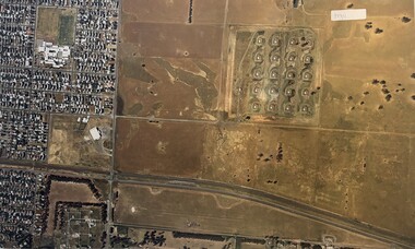
Photograph - Aerial Photographs Of Melbourne Metropolitan Area 1989, Qascophoto, 17th November 1989 & 28th November 1989
... West of McDonald Road (West) Points of Interest: State Electricity Commission of Victoria (SECV) Stores, Brooklyn Wool Stores, Brooklyn Primary School, Half Moon Caravan Park, Footscray Cemetery, Rheems, James Hardy 953.03 - Aerial Photographs Of Melbourne Metropolitan Area 1989.JPG Suburb(s): Ascot Vale, Maribyrnong Area bounded by: Raleigh Road (North), River Street and James Street (South), Holdsworth Street (East), West of Van Ness Avenue (West) Points of Interest: Highpoint City, Fairbairn Park, Hume Pipes, Riverside Golf Course, ICI Laboratories 953.04 - Aerial Photographs Of Melbourne Metropolitan Area 1989.JPG Suburb(s): Albion, Ardeer, Sunshine, Sunshine West Area bounded by: Dubbo Street (North), South of Glengala Road (South), West of Sydney Street (East), Vernon Crescent (West) Points of Interest: Ainsworth Reserve, Selwyn Park, St. ...West of McDonald Road (West) Points of Interest: State Electricity Commission of Victoria (SECV) Stores, Brooklyn Wool Stores, Brooklyn Primary School, Half Moon Caravan Park, Footscray Cemetery, Rheems, James Hardy 953.03 - Aerial Photographs Of Melbourne Metropolitan Area 1989.JPG Suburb(s): Ascot Vale, Maribyrnong Area bounded by: Raleigh Road (North), River Street and James Street (South), Holdsworth Street (East), West of Van Ness Avenue (West) Points of Interest: Highpoint City, Fairbairn Park, Hume Pipes, Riverside Golf Course, ICI Laboratories 953.04 - Aerial Photographs Of Melbourne Metropolitan Area 1989.JPG Suburb(s): Albion, Ardeer, Sunshine, Sunshine West Area bounded by: Dubbo Street (North), South of Glengala Road (South), West of Sydney Street (East), Vernon Crescent (West) Points of Interest: Ainsworth Reserve, Selwyn Park, St. ...953.01 - Aerial Photographs Of Melbourne Metropolitan Area 1989.JPG Suburb(s): Ardeer, Deer Park (Now Derrimut), Sunshine West Area bounded by: Railway Parade (North), Paramount Bouvard (South), Allison Street (East), Approx Station Road (West) Points of Interest: IVI Explosive Bunkers, Railway Siding into ICI off Forrest Street, Former Railway Station Tilburn Road, Sunshine Technical School Annex, Croatian Catholic Centre Sunshine Fitzgerald Road 953.02 - Aerial Photographs Of Melbourne Metropolitan Area 1989.JPG Suburb(s): Brooklyn, Yarraville Area bounded by: South of Somerville Road (North), Westgate Freeway (South), Urwin Street (East). West of McDonald Road (West) Points of Interest: State Electricity Commission of Victoria (SECV) Stores, Brooklyn Wool Stores, Brooklyn Primary School, Half Moon Caravan Park, Footscray Cemetery, Rheems, James Hardy 953.03 - Aerial Photographs Of Melbourne Metropolitan Area 1989.JPG Suburb(s): Ascot Vale, Maribyrnong Area bounded by: Raleigh Road (North), River Street and James Street (South), Holdsworth Street (East), West of Van Ness Avenue (West) Points of Interest: Highpoint City, Fairbairn Park, Hume Pipes, Riverside Golf Course, ICI Laboratories 953.04 - Aerial Photographs Of Melbourne Metropolitan Area 1989.JPG Suburb(s): Albion, Ardeer, Sunshine, Sunshine West Area bounded by: Dubbo Street (North), South of Glengala Road (South), West of Sydney Street (East), Vernon Crescent (West) Points of Interest: Ainsworth Reserve, Selwyn Park, St. Paul Church, Marian College, Ardeer Primary School, Glengala Road Shopping Centre, 953.05 - Aerial Photographs Of Melbourne Metropolitan Area 1989.JPG Suburb(s): Deer Park Area bounded by: Station Road (East), Marcellin Court (West), Irvine Street (North), Deer Street (South) Points of Interest: Deer Park Primary School, Deer Park Play Kindergaten, Deer Park Shopping Centre, St. Peter Chanel Church & School 953.06 - Aerial Photographs Of Melbourne Metropolitan Area 1989.JPG Suburb(s): Derrimut Area bounded by: Future Ring Road (North), South of Boundary Road (South), East of Andersons Swamp (East), West of Fitzgerald Road (West) Points of Interest: Andersons Swamp 953.07 - Aerial Photographs Of Melbourne Metropolitan Area 1989.JPG Suburb(s): Sunshine West Area bounded by: East of Fairbairn Road (East), East of Fitzgerald Road (West), North of Mailey Street (North), South of Talintyre Road (South) Points of Interest: Sunshine West High School, Sunshine Heights Primary School, Castley Reserve, Talintyre Reserve, Talintyre Road Shops, St. Peters School, Sunshine Golf Course, Ralph Reserve, Glengala Primary School 953.08 - Aerial Photographs Of Melbourne Metropolitan Area 1989.JPG Suburb(s): Derrimut, Ravenhall Area bounded by: East of Station Road, now Derrimut Road (East), West of Robinsons Road (West), South of Railway Line (North), North of Future Deer Park Bypass Points of Interest: Old Farms and Quarries 953.09 - Aerial Photographs Of Melbourne Metropolitan Area 1989.JPG Suburb(s): Sydenham, Taylors Lakes, Taylors Hill Area bounded by: Taylors Creek (North), Future Hume Drive (South), West of Future Parmelia Drive (East), Future Hawthorn Grove (West) Points of Interest: Sydenham Reservoir, Sydenham Railway Station, Sydenham Memorial Hall, Sydenham Primary School, Sydenham Recreation Reserve, Catholic Regional College Sydenham, Kingdom Hall of Jehovah's Witnesses 953.10 - Aerial Photographs Of Melbourne Metropolitan Area 1989.JPG Suburb(s): Brooklyn, Tottenham Area bounded by: Stony Creek (North), South of Somerville Road (South), Holmwood Road (East), West of McDonald Road (West) Points of Interest: Monsanto, Dalgety's, Wool Stores, Sims Metals, Farmer & Graziers, Olex Cables, Redbrook Carpets, May & Baker, Cargil Oil, Smorgans 953.11 - Aerial Photographs Of Melbourne Metropolitan Area 1989.JPG Suburb(s): Brooklyn Area bounded by: South of Fourth Avenue (North), South of Bunting Road (South), West of McDonald Road, East of Fitzgerald Road (West) Points of Interest: Market Road, Bunting & Jones Road Quarries, Monsanto, ANI, Market Timber 953.12 - Aerial Photographs Of Melbourne Metropolitan Area 1989.JPG Suburb(s): Brooklyn, Laverton North Area bounded by: South of Bunting Road (North), Buchanan Road (South), Cypress Avenue (East). Little Boundary Road (West) Points of Interest: Jones Road and Old Geelong Road Quarries, Brooklyn Go Kart Track, Sims Metal Foundry, Ralphs, Guiding Star Hotel, Gas & Fuel Substation 953.13 - Aerial Photographs Of Melbourne Metropolitan Area 1989.JPG Suburb(s): Sunshine, Sunshine West Area bounded by: Parsons Street (North), South of Fourth Avenue (South), Alfred Street (East), West of Kororoit Creek (West) Points of Interest: Parsons Reserve, Wheat Silos, H.V. McKay Trade Wing, Tottenham Hotel, Sunshine Carvan Park 953.14 - Aerial Photographs Of Melbourne Metropolitan Area 1989.JPG Suburb(s): Derrimut, Mt. Derrimut, Sunshine West, Area bounded by: East of Allison Street (East), Mt. Derrimut (West), Hilma Street (North), South of old Sunshine Golf Course (South) Points of Interest: Mt. Derrimut, Sunshine Golf Course 953.15 - Aerial Photographs Of Melbourne Metropolitan Area 1989.jpeg Suburb(s): Avondale Height, Braybrook, Sunshine North Area bounded by: Canning Street (North), North of Cranwell Street (South), Medway Golf Course (East), Nottingham Street (West) Points of Interest: Duke Street Quarries, Cranwell Park, Pennell Reserve 953.16 - Aerial Photographs Of Melbourne Metropolitan Area 1989.jpeg Suburb(s): All of City of Sunshine Area bounded by: Maribyrnong River (North), Westgate Freeway (South), Nicholson Street (East), Robinsons Road (West) Points of Interest: General overall of the City of Sunshine 953.17 - Aerial Photographs Of Melbourne Metropolitan Area 1989.jpeg Map is missing 953.18 - Aerial Photographs Of Melbourne Metropolitan Area 1989.jpeg Suburb(s): Braybrook, Maidstone, Sunshine Area bounded by: Ballarat Road (North), North of South Road (South), East of Ashley Street (East), West of Duke Street (West) Points of Interest: Skinner Reserve, Kinder Smith Reserve, Churchill Avenue Shops, St. John College, Industrial Engineering, Invita Carpets, Tottenham Technical School, Carolone Chisholm College, Christ The King Primary School, Sunshine East Primary School, Dyecraft 953.19 - Aerial Photographs Of Melbourne Metropolitan Area 1989.JPG Suburb(s): Laverton North, Sunshine West Area bounded by: North of Boundary Road (North), Sewer Out Fall (South), East of Little Boundary Road (East), East of Future Ring Road (West). Points of Interest: Factories in Laverton Northmelbourne, aerial photograph
