Showing 44 items matching "vegetation study"
-
 University of Melbourne, Burnley Campus Archives
Document, Banyule City Council Significant Trees and Vegetation Study, 1997-1999
... Banyule City Council Significant Trees and Vegetation Study......vegetation study...University of Melbourne, Burnley Campus Archives 500 Yarra Boulevard Richmond melbourne banyule significant trees vegetation study Quotation, discussion and correspondence between Banyule City Council and Centre for Urban Horticulture Banyule City Council Significant Trees and Vegetation Study Document ...Quotation, discussion and correspondence between Banyule City Council and Centre for Urban Horticulturebanyule, significant trees, vegetation study -
University of Melbourne, Burnley Campus Archives
Book, Banyule City Council Significant Trees and Vegetation Study, 1999
... Banyule City Council Significant Trees and Vegetation Study......vegetation study...Banyule City Council Significant Trees and Vegetation Study Book ...Significant Trees of the City of Banyule, 317 pp.banyule, significant trees, vegetation study -
Lakes Entrance Historical Society
Map - Alpine Study Area - Vegetation, Land Conservation Council
... Alpine Study Area - Vegetation...Vegetation...study...Lakes Entrance Historical Society 4 Marine Parade Lakes Entrance gippsland Vegetation study Land conservation Map No. 6 Map shows tree names in each forest area as open forest, woodland and forest, cleared land. ...Map shows tree names in each forest area as open forest, woodland and forest, cleared land.Map No. 6vegetation, study, land conservation -
 Lakes Entrance Historical Society
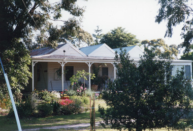
Photograph - Historic House, 53 Carpenter Street, Lakes Entrance, Victoria, 2000
... Vegetation... Houses... Heritage Study...Additions built by Dr Fitzpatrick who shaped timber with tomahawk as he couldn't use a saw. Vegetation Houses Heritage Study Colour photograph of a triple gabled weatherboard dwelling with veranda on two sides with one end enclosed. ...First part of house transported to Carpenter Street, from the flats behind Sale Cemetery by Dr Fitzpatrick as holiday home 1950's. Additions built by Dr Fitzpatrick who shaped timber with tomahawk as he couldn't use a saw.Colour photograph of a triple gabled weatherboard dwelling with veranda on two sides with one end enclosed. Plain veranda posts and brackets. Pretty cottage garden. Situated at 53 Carpenter Street, Lakes Entrance, Victoria.vegetation, houses, heritage study -
Whitehorse Historical Society Inc.
Document, Management of the vegetation of Wandinong Sanctuary, 1998
... Study of vegetation management of Wandinong Sanctuary, prep. by Elizabeth Donoghue....Study of vegetation management of Wandinong Sanctuary, prep. by Elizabeth Donoghue. ...Study of vegetation management of Wandinong Sanctuary, prep. by Elizabeth Donoghue.Study of vegetation management of Wandinong Sanctuary, prep. by Elizabeth Donoghue.Study of vegetation management of Wandinong Sanctuary, prep. by Elizabeth Donoghue.wandinong sanctuary, native plants, weeds -
 Kiewa Valley Historical Society
Report - Alpine Study Area Volume 2 Maps, Land Conservation Council, 1970s
... Study Area produced by the Land Conservation Council. Maps include 1. Public land and descriptive blocks. 2. Physiography. 3. Topography. 4. Geology (missing). 5. Rainfall and water resources. 6. Vegetation...Study Area produced by the Land Conservation Council. Maps include 1. Public land and descriptive blocks. 2. Physiography. 3. Topography. 4. Geology (missing). 5. Rainfall and water resources. 6. Vegetation ...The Victorian Environmental Assessment Council and the former Environment Conservation Council (ECC) and Land Conservation Council (LCC) have completed 36 land use investigations over more than 35 years, including 27 regional reviews. They provide a framework for use of Public Land in Victoria. The Land Conservation Council was established by the Land Conservation Act 1970.These maps provide an assessment of the Alpine area at the time the maps were created. Some of the topics eg. Rainfall and water resources may change over the years thus providing a comparative analysis. Others may provide information for future development such as mineral exploration, building of a dam / tunnel etc.Blue box shaped folder containing 9 of 10 Maps of the Alpine Study Area produced by the Land Conservation Council. Maps include 1. Public land and descriptive blocks. 2. Physiography. 3. Topography. 4. Geology (missing). 5. Rainfall and water resources. 6. Vegetation 7. Land systems. 8. Recreation. 9. Primary production. 10. Minerals Ex library item. Stamped in red "Discarded From Stock / Swan Hill Regional Libraryalpine area, maps of alpine area, land conservation council -
 Kiewa Valley Historical Society
Papers - Observation Walk on the Bogong High Plains. x5
... Students study the Bogong High Plains noting geology, history, vegetation and evolution / changes....Kiewa Valley Historical Society Mount Beauty Information Centre 31 Bogong High Plains Rd Mt Beauty high-country Students study the Bogong High Plains noting geology, history, vegetation and evolution / changes. ...Students study the Bogong High Plains noting geology, history, vegetation and evolution / changes.Environmental studies includes the effect of people, horses, skiing, infrastructure etc.Typed and hand written notes on the Bogong High Plains for students observing the vegetation. It includes geology and early history.bogong high plains, grazing, vegetation -
 Kiewa Valley Historical Society
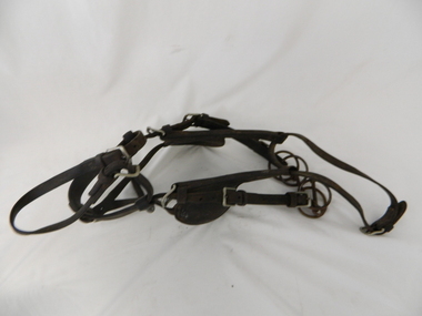
Bridle Horse, circa mid to late 1900's
... A scientific study started in 1947 to study the impact of grazing cattle/sheep on the natural Alpine and sub Alpine vegetation found grazing cattle had an adverse affect on the natural Alpine and sub alpine vegetation, and grazing on the plains was stopped by the Victorian Government in 2005.This "camp draft" on the Bogong High Plains could take up to six weeks. horse country leather bridle gaiters high country grazing cattlemen laces studs This harness bridle includes "blinders, winklers or blinkers" and would therefore be used on a pack or "working" horse. ...This stock horse bridle was probably used in the mid 1900's. This was the period when cattle and sheep mustering was at its prime. The movement of cattle and sheep was by mounted stock horse only and not by other methods. Northern territory cattle stations in the late 1900's started to use helicopters for "cattle control". In the KIEWA Valley/Bogong High Plains and other rural cattle/sheep producing areas required well trained stock horses and stockmen for cattle/sheep control. It is only in the later 1900's that motor bikes and four wheeled quad-bikes have taken over, in part, from the mounted stockman.This horse bridle is very significant to the Kiewa Valley because of the early introduction of cattle and sheep stations in what initially was regarded as a semi remote valley location. The maintenance of cattle and sheep in the Kiewa Valley was, and still is an important requirement of livestock management. A good stock horse bridle is important, especially during the period when cattle and sheep were grazed on the Bogong High Plains. The mustering and and moving cattle/sheep from the valley pastures to the high country was a demanding and dangerous exercise requiring "sure footed" stock horses.The "good specialised" bridle was a vital part of this cattle/sheep mustering. A scientific study started in 1947 to study the impact of grazing cattle/sheep on the natural Alpine and sub Alpine vegetation found grazing cattle had an adverse affect on the natural Alpine and sub alpine vegetation, and grazing on the plains was stopped by the Victorian Government in 2005.This "camp draft" on the Bogong High Plains could take up to six weeks.This harness bridle includes "blinders, winklers or blinkers" and would therefore be used on a pack or "working" horse. This bridle has rings on each end of the browband. The bridle is one used by a horse working in a team configuration pulling a heavy cart or wagon. The bridle has ten adjustable straps to allow it to accommodate a variety of horse sizes. See KVHS 0495 for a stock horse saddle.horse, country, leather bridle, gaiters, high country grazing, cattlemen, laces, studs -
 Kiewa Valley Historical Society
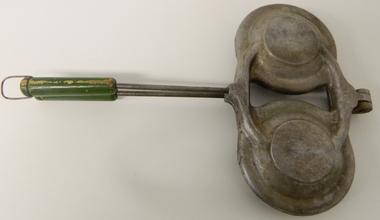
Pie Iron Camping, circa mid to late 1900s
... A scientific study started in 1947, to study the impact of grazing cattle on the natural Alpine and sub Alpine vegetation found grazing cattle had an adverse affect on the natural Alpine and sub alpine vegetation, and grazing on the plains was stopped by the Victorian Government in 2005....A scientific study started in 1947, to study the impact of grazing cattle on the natural Alpine and sub Alpine vegetation found grazing cattle had an adverse affect on the natural Alpine and sub alpine vegetation, and grazing on the plains was stopped by the Victorian Government in 2005. ...This Pie Iron was used in the mid to late 1900's when stock, both cattle and sheep, were grazed on the Bogong High Plains. Providing meals for stockmen over open fires, even in log cabins in the Victorian Alpine region, was usually by a "camp cook" or a stockman designated "cook" from the Valley station/property. The use of "camping cooking utensils were a necessity and not a "weekend" affair. Stockmen could spend up to six weeks on the plains and all their cooking needs required had to "pack horsed" from the valley below. A scientific study started in 1947, to study the impact of grazing cattle on the natural Alpine and sub Alpine vegetation found grazing cattle had an adverse affect on the natural Alpine and sub alpine vegetation, and grazing on the plains was stopped by the Victorian Government in 2005.This item is highly significant to the Kiewa Valley as it demonstrates the kind of cooking utensils that were required for camp drafts in the Bogong High Plains environment. As the control of cattle and sheep in the High Plains was very demanding upon horse and rider, good "tucker" was a pre- requisite for a successful operation. As the time spent in this remote location was governed by the climatic condition maximum utilisation of the very good pastures in the High Plains was crucial to a successful and profitable season.This pie iron has two pie forms in horizontal configuration and both top and base rounded forms are connected at one end (Top) with pop rivet application. This application allows for the "opening" up of the two halves. The bodies are made from cast iron in a "cup" form and a metal rod and wooden handle extend to permit the opening of the two sides. The inner side of the "cups" are smooth which relates to pie requirements and not the jaffle/sandwich irons. A clasp metal "D" ring is installed at the end of one wooden handle (to keep the iron in the close/cooking position).camp fire cooking utensils, hot plate, cast iron cooking appliances, pie irons, jaffle irons, drovers kitchen -
 Kiewa Valley Historical Society
Collection - Ian Roper
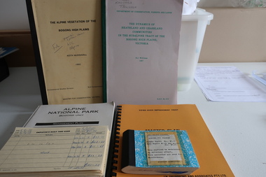
... studies ordered by the Victorian Government and the Alpine shire. History of the Kiewa Valley and North East Victoria including the airport at Mount Beauty Ian Roper Mount Beauty Airport pygmy possums vegetation A collection of publications and Items significant to the Kiewa Valley Including Kiewa Valley and Surrounds, the Kiewa River, and Pygmy Possums. ...Various reports and studies ordered by the Victorian Government and the Alpine shire.History of the Kiewa Valley and North East Victoria including the airport at Mount BeautyA collection of publications and Items significant to the Kiewa Valley Including Kiewa Valley and Surrounds, the Kiewa River, and Pygmy Possums. Also items and reports relating to the North East of Victoria. 1. Kiewa River Improvement Trust- Master Plan 1984. 2. Guidelines Conservation Mountain Pygmy Possum -Management Strategy 1989. 3. Proposed Interim Management Plan -Bogong National Park 1983. 4. The Dynamics of Heathland and Grassland Communities in the Subalpine Tract - Bogong High Plains 1987. 5. Alpine National Park Bogong Unit -Management Plan 1992.6. Alpine Vegetation of the Bogong High Plains - Bogong High Plains 1982. 7. Early 1970s onwards, records of banking, receipts, landing fees, letters, photos, key, minutes, visitor book, record of landings (book), postcards, SEC Victoria's Kiewa Valley Brochure - Mt Beauty Airport History 1`977+ian roper, mount beauty airport, pygmy possums, vegetation -
 Kiewa Valley Historical Society
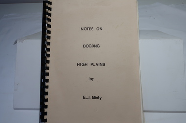
Book - Notes on Bogong High Plains by E. J. Minty, Notes on Bogong High Plains by E. J. Minty
... Vegetation and slide set index 4. Climate ... Important knowledge/study for the construction of the Kiewa Hydro Electric Scheme on the Bogong High Plains. ...The book includes detailed accounts in 4 sections of 1. History and Exploration 2. General Geology 3. Vegetation and slide set index 4. Climate ...Important knowledge/study for the construction of the Kiewa Hydro Electric Scheme on the Bogong High Plains.Cream cardboard cover book with black spiral binding. Title printed in black on cover. 46 pages printed on both sides includes diagrams. Clear blue plastic sheet as last page.e. j. minty, bogong high plains, kiewa hydro electric scheme -
 Kiewa Valley Historical Society
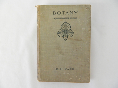
Book - Reference Botany, Botany - A Junior Book For Schools, 1927
... Being in a rural area students were able to identify local vegetation to the various life cycles of plants presented in this mainly United Kingdom/European referenced book. The students in the Kiewa Valley and attending a rural school, where in a position to study all the fundamental teaching that this book encompassed. ...This book was a highly regarded reference book for students in primary and lower secondary schools within Victoria from the late 1800s to the mid 1900s. The book provided students with the fundamental knowledge of botany for the era in which it was produced. As this book was targeting a junior schooling level (basic), it could cover a greater and extended reader population. Teaching institutions could, because of its straight forward, basic written information, retain this book's circulation for a greater length of time, thereby optimising the return against the greater initial costs of importing it from England.This book was produced in a time where learning was at a relatively slower pace (due to a smaller source and supply of material). The availability of a large range of cheap reference books such as that offered from 1971 on wards via the internet "Project Guttenberg" in the form of electronic books, has dramatically provided a larger source of reference material. The significance of this book on botany, is that it was highly effective for the era in which it was produced and in particular the students at a rural based school. Being in a rural area students were able to identify local vegetation to the various life cycles of plants presented in this mainly United Kingdom/European referenced book. The students in the Kiewa Valley and attending a rural school, where in a position to study all the fundamental teaching that this book encompassed. This in one way provided students in the valley a slightly better appreciation between book and real life (on the land, in the field and by the river). Later publications of this book had additional Australian references in them.This hard covered book(cloth strengthened) is faded(aged) beige in colour and consists of 204 pages. It is printed in English (black print) on both sides and contains illustrations of both free hand sketches and photographs of plants, both foliage and roots systems. The book is arranged in three sections: three pages of preface, two of contents (28 chapters). The last four pages contain the appendix and index.On spine "BOTANY" underneath "R.H. YAPP" and at bottom the Cambridge coat of Arms and below this "CAMBRIDGE" The front cover "BOTANY" underneath this "A JUNIOR BOOK FOR SCHOOLS" and below this a an illustration of a four leaf petal(flower of Germander Speedwell) the same as appears on the cover of edition 2, however this book is edition 3. At the bottom is "R.H. YAPPschool, botany, text books, science experiments, nature -
 Kiewa Valley Historical Society
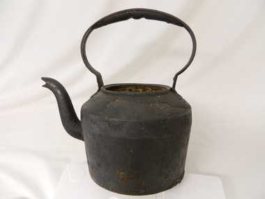
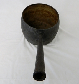
Kettle Cast Iron, Circa 1950
... A scientific study started in 1947 to study the impact of grazing cattle on the natural Alpine and sub Alpine vegetation found grazing cattle had an adverse affect on the natural Alpine and sub alpine vegetation, and grazing on the plains was stopped by the Victorian Government in 2005.This "camp draft" could take up to six weeks. camp fire cooking utensils hot plate cast iron cooking appliance drovers kitchen Clark Quality This large cast iron kettle holds a capacity of three pints of water/tea. ...This kettle was used by pioneer families, mainly rural, folk that needed a constant readily available source of boiling water, in or mainly outside the homestead.. This kettle was used in the early to late 1900's for the refreshment of stock men and farmers that had irregular "tea" breaks under sometimes hard and gruelling conditions.This kettle belonged and was used by a Kiewa Valley, pioneer family, the Roper Family. This kettle was moved from their Kiewa Valley property to their hut built on the Bogong High Plains. A scientific study started in 1947 to study the impact of grazing cattle on the natural Alpine and sub Alpine vegetation found grazing cattle had an adverse affect on the natural Alpine and sub alpine vegetation, and grazing on the plains was stopped by the Victorian Government in 2005.This "camp draft" could take up to six weeks.This large cast iron kettle holds a capacity of three pints of water/tea. It has a flat base and mushroom shaped handle welded onto the "pot" below the rim of the pot opening. It has a rim to position the tea pot lid but no lid. It has a curved spout "welded" to the main body.Clark Qualitycamp fire cooking utensils, hot plate, cast iron cooking appliance, drovers kitchen -
 Kiewa Valley Historical Society
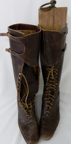
Boots Riding Women's, Circa 1950's
... In 1947 a scientific research project started to provide an impact analysis of any damage to alpine vegetation by cattle grazing in the Alpine regions incorporating the Bogong High Plains area. This monitoring is the longest running ecological study ever undertaken in Australia. ...In 1947 a scientific research project started to provide an impact analysis of any damage to alpine vegetation by cattle grazing in the Alpine regions incorporating the Bogong High Plains area. This monitoring is the longest running ecological study ever undertaken in Australia. ...This pair of "adjustable" boots came from the 1950's era in which the majority of footwear was either locally manufactured or imported from England or Europe. Quality hard wearing leather was a rural necessity especially for the cattle mustering activity in the Kiewa Valley and the Bogong High Plains region. The late 1900's provided a cheaper made riding boot from Asia, however many rural based riders still prefer an Australian made boot. The better quality (stronger stitching) of Australian boots is the main considerations of "stock horse riders". In 1947 a scientific research project started to provide an impact analysis of any damage to alpine vegetation by cattle grazing in the Alpine regions incorporating the Bogong High Plains area. This monitoring is the longest running ecological study ever undertaken in Australia. From this study, compelling evidence was presented to the Victorian Government to cease cattle grazing in the Alpine regions including the Bogong High Plains. All grazing was banned by the Victorian Government in 2005. Recreational horse riding within the Bogong High Plains is still permitted.These pair of women's riding boots are very significant to the Kiewa Valley as the boots were worn by one of the descendants of a pioneer family living and operating a cattle station before the SEC Hydro Electricity Scheme opened up the semi remote rural location in the 1950's. These boots were worn during the annual six weeks (approx.) mustering of cattle in the Bogong High Plains location (Victorian Alps region). The owner of these boots was Clare Roper, part of the Roper Family who built a "lodging" hut on the "High Plains" for accommodating riders during the periods (up to six weeks) when controlling grazing cattle during the summer muster seasons. It was unusual for women in the early to mid 1900's to go up on the High Plains to join the muster, which Clare Roper often did. These boots have high historical significance and good interpretive capacity.These brown "knee high" lady riding boots, are fastened by long "boot" laces which go from the base of the "fastening" position to a boot height of 22 cm. At the top end of the boot is a leather flap which crosses the front section of the boot and is fastened to the outside leg region by two straps. These provide the wearer with an adjustable tie. The boot has a "tongue" of 22 mm long. The boot has six pairs of metal boot lace "hooks" and eight pairs of boot lace "eyelets".ladies riding boots. cattle mustering footwear. rural footwear. cattlemen. bogong high plains. roper family. horses. -
 Kiewa Valley Historical Society
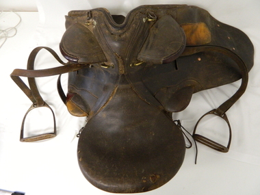
Saddle Horse Stock, Circa 1950
... A scientific study started in 1947 to study the impact of grazing cattle on the natural Alpine and sub Alpine vegetation found grazing cattle had an adverse affect on the natural Alpine and sub alpine vegetation, and grazing on the plains was stopped by the Victorian Government in 2005.This "camp draft" in the High Plains could take up to six weeks. horse country leather gaiters high grazing cattlemen laces studs This all leather "stock horse" saddle shows plenty of wear. ...This stock horse saddle was probably used in the mid 1900's. This was the period when cattle mustering was at its prime. The movement of cattle was by mounted stock horse only and not by other methods. Northern territory cattle stations in the late 1900's started to use helicopters for "cattle control". In the KIEWA Valley/Bogong High Plains and other rural cattle producing areas required well trained stock horses and stockmen for cattle control. It is only in the later 1900's that motor bikes and four wheeled quad-bikes have taken over, in part, from the mounted stockman.This horse saddle is very significant to the Kiewa Valley because of the early introduction of cattle stations in what initially was regarded as a semi remote location. The maintenance of cattle in the Kiewa Valley is and was an important requirement. A good stock horse saddle as and is important, especially during the period when cattle were grazed on the Bogong High Plains. The mustering and and moving cattle from the valley pastures to the high country was a demanding and dangerous exercise requiring "sure footed" stock horses.The "good" saddle was a vital part of this cattle mustering. A scientific study started in 1947 to study the impact of grazing cattle on the natural Alpine and sub Alpine vegetation found grazing cattle had an adverse affect on the natural Alpine and sub alpine vegetation, and grazing on the plains was stopped by the Victorian Government in 2005.This "camp draft" in the High Plains could take up to six weeks.This all leather "stock horse" saddle shows plenty of wear. It is in "full harness" configaration with stirrups and leg protectors horse, country, leather, gaiters, high, grazing, cattlemen, laces, studs -
 Kiewa Valley Historical Society
Saucepan, circa mid to late 1900's
... A scientific study started in 1947 to study the impact of grazing cattle on the natural Alpine and sub Alpine vegetation found grazing cattle had an adverse affect on the natural Alpine and sub alpine vegetation, and grazing on the plains was stopped by the Victorian Government in 2005. camp fire cooking utensils hot plate cast iron cooking appliance drovers kitchen On bottom of pan (underside) "N0. 8 JSJ SIDDONS" on the other side "WEST BROMWICH 5 QUARTS" This large (black, soot infused) cast iron saucepan has a "ten pint" holding capacity and was used on the "open fire", possible on the fire direct. ...This large deep pan (with a long handle) was used by pioneer families, mainly rural folk, that needed a pan which could cope with an open fire heat source, in or mainly outside the homestead. This pan was used in the early to late 1900's for the "stews" and other meals required by hard working stock men and farmers that had irregular "lunch and dinner" breaks under sometimes hard and gruelling conditions. Hot plates were normally not in use.This "open fire" saucepan belonged, and was used by a Kiewa Valley, pioneer family, the Roper Family. This saucepan was moved from their Kiewa Valley property to their hut built on the Bogong High Plains. This saucepan was one of an array of "open fire" cooking utensils used in the "camp draft" grazing in the Bogong High Plains and this could take up to six weeks. This kettle belonged and was used by a Kiewa Valley, pioneer family, the Roper Family. This kettle was moved from their Kiewa Valley property to their hut built on the Bogong High Plains. A scientific study started in 1947 to study the impact of grazing cattle on the natural Alpine and sub Alpine vegetation found grazing cattle had an adverse affect on the natural Alpine and sub alpine vegetation, and grazing on the plains was stopped by the Victorian Government in 2005.This large (black, soot infused) cast iron saucepan has a "ten pint" holding capacity and was used on the "open fire", possible on the fire direct. It has a long all metal handle coming from the top half of the pot and angled at approximately sixty degrees upwards. This angle insures that both distance from flame intensity and least bending of knees when lifting is at a minimum.On bottom of pan (underside) "N0. 8 JSJ SIDDONS" on the other side "WEST BROMWICH 5 QUARTS"camp fire cooking utensils, hot plate, cast iron cooking appliance, drovers kitchen -
 Kiewa Valley Historical Society
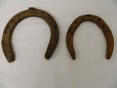
Shoes Horse Stock and Draft, early 1900's
... A scientific study started in 1947 to study the impact of grazing cattle on the natural Alpine and sub Alpine vegetation found grazing cattle had an adverse affect on the natural Alpine and sub alpine vegetation, and grazing on the plains was stopped by the Victorian Government in 2005.This "camp draft" in the High Plains could take up to six weeks. working horses bogong high plains camp draft grazing cattle bogong high plains Both these horse shoes have been "roughly" made but are specifically made for the type of horse which wore them. ...These horse shoes (one a stock horse and one a draft horse) were probably used in the mid 1900's. They have been roughly made suggesting that a professional blacksmith was not instrumental in their manufacture. On smaller or remote cattle stations either the lead stock man or owner would "fire up" the kiln to provide the adjustments required to the horse shoe to ensure a "tight" fit. The larger cattle stations had a "professional" blacksmith to cover all their "working" horses. Larger properties eg.large Northern territory cattle stations use helicopters for "cattle control".These horse shoes are very significant to the Kiewa Valley because of the early introduction of cattle stations in what initially was regarded as a semi remote location. The maintenance of horses hooves is an important requirement, especially during the period when cattle were grazed on the Bogong High Plains. The mustering and and moving cattle from the valley pastures to the high country was a demanding and dangerous exercise requiring "sure footed" stock horses. A scientific study started in 1947 to study the impact of grazing cattle on the natural Alpine and sub Alpine vegetation found grazing cattle had an adverse affect on the natural Alpine and sub alpine vegetation, and grazing on the plains was stopped by the Victorian Government in 2005.This "camp draft" in the High Plains could take up to six weeks.Both these horse shoes have been "roughly" made but are specifically made for the type of horse which wore them. The smaller of the two is for the stock horse/riding horse and the lager one is for the larger draft horse. Each horse type has a specific role to play in the the type of activity it was used for. The small horse shoe has six "nail" holes for attachment to the horse hoof by special nails. The larger shoe has seven "nail" holes. Both have the three quarter moon shape which fits the curvature of the horses hooves. working horses, bogong high plains camp draft, grazing cattle bogong high plains -
 Eltham District Historical Society Inc
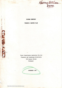
Document - Report, Tract Consultants Australia Pty Ltd, Eltham Cemetery: Towards a Master Plan, Nov 1987
... Principally, the study will examine options available for development of the Cemetery. These options will explore possible boundaries, cemetery design, vegetation, the overall environment, landscaping and financial planning for the Cemetery operations. ...Principally, the study will examine options available for development of the Cemetery. These options will explore possible boundaries, cemetery design, vegetation, the overall environment, landscaping and financial planning for the Cemetery operations. ...BACKGROUND The Eltham Cemetery is of historic significance to the Eltham area. The Trust was established in 1858 and has administered and maintained the cemetery from that date right up to the present. Among the more noteworthy graves is that of Sir William Irvine, a former State Premier and Chief Justice of Victoria. Eltham Cemetery is surrounded on three sides by urban development. Montsalvat Artists Colony adjoins the remaining (eastern) side. A Joint Select Committee of Parliament called the “Mortuary Industry and Cemeteries Administration Committee" (MICA) enquired into the land requirements at the Eltham Cemetery in 1986. The MICA recommendations contained in its 1986 report are included in the Appendices attached to this report. Although the recommendations have not been adopted by the Government it is interesting to note that the MICA report recommended the use of the bulk of the land for cemetery purpose. In June of 1987, the Cemetery Trust was expanded to include additional members from the Eltham Community by the Minister for Health. At the same time, he instructed the Trust to resolve the land requirement issues. As a result of this Ministerial direction, Tract Consultants has been instructed by the Eltham Cemetery Trust to prepare a report addressing the issues raised in the Minister's letter (see Appendix 1) to the Trust. Principally, the study will examine options available for development of the Cemetery. These options will explore possible boundaries, cemetery design, vegetation, the overall environment, landscaping and financial planning for the Cemetery operations. Appendix 2 details the Cemetery Trusts Terms of Reference for the Study. Before commencing the study in detail, additional basic information was sought; viz: a) sub-soil and rock analysis; and b) feature survey by a Licensed Surveyor. The results from both exercises are included as appendices to this report. Section three includes a summary of the findings along with other analytical results. Also: Eltham Cemetery - planning bewteen 1859 to 1860; research by Alan Sheehan April 2015, collated by Harry Gilham, EDHS, April 2016 (2 pages) PROV Guide 5: Cemetery Records (8 pages), printed 7 May 2014Development of Eltham Cemeteryeltham cemetery trust, master plan, mica, montsalvat, mortuary industry and cemeteries administration committee, tract consultants -
![Book - Map, Land Conservation Council, Melbourne Study Area Report, [December 1973]](/media/collectors/4f729f7b97f83e03086018a5/items/6469bc241d76dd4b008a829f/item-media/646b0013d841f8920fa4323c/item-fit-380x285.jpg?cb=6) Eltham District Historical Society Inc
Eltham District Historical Society IncBook - Map, Land Conservation Council, Melbourne Study Area Report, [December 1973]
... Melbourne Study Area Public land and descriptive blocks, Population description, Geology, Physiography, topography and rainfall, vegetation and water supply. ...The Melbourne Study Report is a series of volumes describing the physical nature of the land and its environment, examines the likely forms of land use, and assesses the hazards associated with these uses. This is Volume 2 (coloured maps). The first page featues a black and white map described as "Shire of Diamond Valley" with public land marked in yellow. Followed by eight large fold out maps. Melbourne Study Area Public land and descriptive blocks, Population description, Geology, Physiography, topography and rainfall, vegetation and water supply. The Land Conservation Act 1970 established the Land Conservation Council whose functions is to "carry out investigations and make recommendations to the Minister with respect to the use of public land in order to provide for the balanced use of land in Victoria. This report sets out to describe and assess the natural resources of the public lands in the Melbourne area and provides a factual basis on which members of the community may base submissions to the [Land Conservation] Council of Victoria.A collection of eight large fold out coloured maps published in a bound book formnon-fictionThe Melbourne Study Report is a series of volumes describing the physical nature of the land and its environment, examines the likely forms of land use, and assesses the hazards associated with these uses. This is Volume 2 (coloured maps). The first page featues a black and white map described as "Shire of Diamond Valley" with public land marked in yellow. Followed by eight large fold out maps. Melbourne Study Area Public land and descriptive blocks, Population description, Geology, Physiography, topography and rainfall, vegetation and water supply. The Land Conservation Act 1970 established the Land Conservation Council whose functions is to "carry out investigations and make recommendations to the Minister with respect to the use of public land in order to provide for the balanced use of land in Victoria. This report sets out to describe and assess the natural resources of the public lands in the Melbourne area and provides a factual basis on which members of the community may base submissions to the [Land Conservation] Council of Victoria. maps, shire of diamond valley, population, geology, topography, rainfall, vegetation, water supply, land use, public lands -
 Greensborough Historical Society
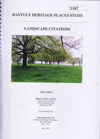
Book, Banyule Heritage Places Study. Vol. 3: Landscape Citations, 1999_07
... This volume (3) of the Banyule Heritage Places Study: Landscape Citations deals significant vegetation and landscapes within the City of Banyule....Greensborough Historical Society 34A Glenauburn Road Lower Plenty Lower Plenty melbourne This volume (3) of the Banyule Heritage Places Study: Landscape Citations deals significant vegetation and landscapes within the City of Banyule. historic landscapes city of banyule 127 pages, colour illus., maps. ...This volume (3) of the Banyule Heritage Places Study: Landscape Citations deals significant vegetation and landscapes within the City of Banyule.127 pages, colour illus., maps. Spiral binding.historic landscapes, city of banyule -
 Greensborough Historical Society
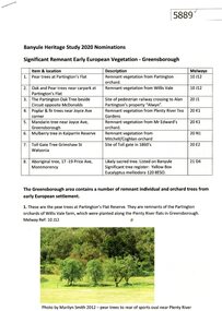
Document - Submission, Anne Paul et al, Banyule Heritage Study 2020 Nominations: Significant remnant early European vegetation - Greensborough, 2020
... Banyule Heritage Study 2020 Nominations: Significant remnant early European vegetation - Greensborough...study 2020...orchards greensborough...vegetation...Submissions made by Norm Colvin and Anne Paul on behalf of the Greensborough Historical Society to the Banyule Heritage Study 2020, citing significant remnant early European vegetation, particularly from orchards developed by Greensborough pioneer families....Greensborough Historical Society 34A Glenauburn Road Lower Plenty Lower Plenty melbourne Submissions made by Norm Colvin and Anne Paul on behalf of the Greensborough Historical Society to the Banyule Heritage Study 2020, citing significant remnant early European vegetation, particularly from orchards developed by Greensborough pioneer families. banyule heritage study 2020 orchards greensborough vegetation Handwritten description on back of photographs 5 p. typescript with four colour photographs Banyule Heritage Study 2020 Nominations: Significant remnant early European vegetation - Greensborough Document Submission Anne Paul Norm Colvin Greensborough Historical Society ...Submissions made by Norm Colvin and Anne Paul on behalf of the Greensborough Historical Society to the Banyule Heritage Study 2020, citing significant remnant early European vegetation, particularly from orchards developed by Greensborough pioneer families.5 p. typescript with four colour photographsHandwritten description on back of photographsbanyule heritage study 2020, orchards greensborough, vegetation -
 Eltham District Historical Society Inc
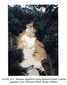
Work on paper (Sub-Item) - Photograph, Riparian vegetation along Diamond Creek. Looking upstream from Diamond Street Bridge, Eltham
... Eltham District Historical Society Inc 728 Main Rd Eltham melbourne Colour photograph of a muddy creek (probably after a downpour) with plants growing on the water's edge along both banks of the creek, including trees, shrubs, grasses and vines. eltham creek vegetation diamond street bridge Diamond Creek Image printed on A4 page from 04997 Diamond Creek Basin Study, 1980 Riparian vegetation along Diamond Creek. ...Colour photograph of a muddy creek (probably after a downpour) with plants growing on the water's edge along both banks of the creek, including trees, shrubs, grasses and vines. eltham, creek, vegetation, diamond street, bridge, diamond creek -
 Eltham District Historical Society Inc
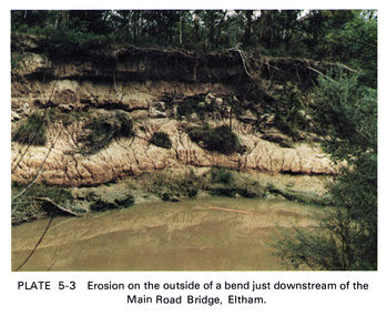
Work on paper (Sub-Item) - Photograph, Erosion on the outside of a bend just downstream of the Main Road Bridge, Eltham
... Eltham District Historical Society Inc 728 Main Rd Eltham melbourne Colour photograph of a muddy Diamond Creek (probably after a downpour) with siginificant water erosion apparent at the bend of the creek in Eltham. eltham creek vegetation Diamond Creek erosion Image printed on A4 page from 04997 Diamond Creek Basin Study, 1980 Erosion on the outside of a bend just downstream of the Main Road Bridge, Eltham Work on paper Photograph ...Colour photograph of a muddy Diamond Creek (probably after a downpour) with siginificant water erosion apparent at the bend of the creek in Eltham.eltham, creek, vegetation, diamond creek, erosion -
 Eltham District Historical Society Inc
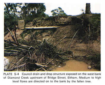
Work on paper (Sub-Item) - Photograph, Council drain and drop structure exposed on the west bank of Diamond Creek upstream of Bridge Street, Eltham
... Mediun to high level water flows are directed on to the bank by the fallen tree. eltham creek diamond creek bridge street drainage waterflow vegetation Image printed on A4 page from 04997 Diamond Creek Basin Study, 1980 Council drain and drop structure exposed on the west bank of Diamond Creek upstream of Bridge Street, Eltham Work on paper Photograph ...Colour photograph of a muddy creek (probably after a downpour) showing council drain and drop structure exposed on the west bank of Diamond Creek upstream of Bridge Street, Eltham. Mediun to high level water flows are directed on to the bank by the fallen tree.eltham, creek, diamond creek, bridge street, drainage, waterflow, vegetation -
 Eltham District Historical Society Inc
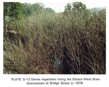
Work on paper (Sub-Item) - Photograph, Dense vegetaton lining the Eltham West Drain downstream of Bridge Street in 1976, 1976
... Eltham District Historical Society Inc 728 Main Rd Eltham melbourne Colour photograph of dense vegetation lining the Eltham West drain downstream of Bridge Street, Eltham eltham vegetation weeds eltham west drain Image printed on A4 page from 04997 Diamond Creek Basin Study, 1980 Dense vegetaton lining the Eltham West Drain downstream of Bridge Street in 1976 Work on paper Photograph ...Colour photograph of dense vegetation lining the Eltham West drain downstream of Bridge Street, Elthameltham, vegetation, weeds, eltham west drain -
 Otway Districts Historical Society
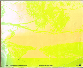
Book, Land Conservation Council, Report on the Corangamite Study Area, May 1976
... Otway Districts Historical Society Cliff Young Drive Beech Forest great-ocean-road The Report describes and assesses the natural resources of public land in the Corangamite study area, and provides a factual basis on which members of the community may base their submissions to the Council. Land Conservation Council; Corangamite; geology; physiography; climate; water resources; soils; vegetation; fauna; Report on the Corangamite study area. ...The Report describes and assesses the natural resources of public land in the Corangamite study area, and provides a factual basis on which members of the community may base their submissions to the Council.Report on the Corangamite study area. Land Conservation Council. Melbourne; Land Conservation Council; May 1976. x, 310 p.; illus, maps (separate). Soft cover.land conservation council; corangamite; geology; physiography; climate; water resources; soils; vegetation; fauna; -
 Lakes Entrance Historical Society
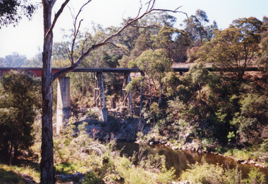
Photograph - Boggy Creek bridge Nowa Nowa, Victoria, 1998
... Lakes Entrance Historical Society 4 Marine Parade Lakes Entrance gippsland Re Heritage Study Bridges Waterways Transport Colour photograph of the railway bridge over Boggy Creek, showing the bridge high above the waterway, rocky terrain and scrubby vegetation. ...Re Heritage StudyColour photograph of the railway bridge over Boggy Creek, showing the bridge high above the waterway, rocky terrain and scrubby vegetation. Nowa Nowa, Victoria,bridges, waterways, transport -
Lakes Entrance Historical Society
Book, Calder Stuart and Winty, Lake Bunga Foreshore Reserve its life and Landscape, 1985
... A study of the topography, vegetation and fauna of the Lake Bunga Victoria area, and relationship with the coastal environment. ...Lakes Entrance Historical Society 4 Marine Parade Lakes Entrance gippsland Topography Vegetation Natural History A study of the topography, vegetation and fauna of the Lake Bunga Victoria area, and relationship with the coastal environment. ...A study of the topography, vegetation and fauna of the Lake Bunga Victoria area, and relationship with the coastal environment. Revised edition 1985topography, vegetation, natural history -
Lakes Entrance Historical Society
Book, Land Conservation Council Victoria East Gippsland Study Area, 1974
... Report describing the nature of environmental features, together with the character and distribution of various natural resources of the East Gippsland, Victoria, study area, comprising land in the old Shire of Orbost. History, vegetation, flora, fauna,...History, vegetation, flora, fauna, Land Conservation Council Victoria East Gippsland Study Area Book ...Report describing the nature of environmental features, together with the character and distribution of various natural resources of the East Gippsland, Victoria, study area, comprising land in the old Shire of Orbost. History, vegetation, flora, fauna,vegetation, natural history, vegetation -
Lakes Entrance Historical Society
Book, Land Conservation Council Victoria Gippsland Lakes Hinterland Area, 1982
... Lakes Entrance Historical Society 4 Marine Parade Lakes Entrance gippsland Waterways Gippsland Natural History Vegetation Report describing the physical nature of the land in the Gippsland Lakes (Victoria) Hinterland Study area. ...Report describing the physical nature of the land in the Gippsland Lakes (Victoria) Hinterland Study area. History, climate, geomorphology, land use, flora and fauna are presented. 1 map in pocket.waterways, gippsland, natural history, vegetation