Showing 33 items matching "victoria reef gold mines plan."
-
 Bendigo Historical Society Inc.
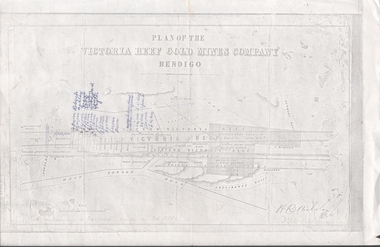
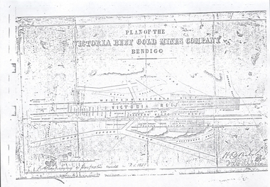
Document - VICTORIA REEF GOLD MINES COMPANY BENDIGO PLAN
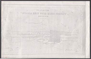
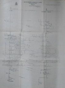
... VICTORIA REEF GOLD MINES COMPANY BENDIGO PLAN...Victoria Reef Gold Mines Company Bendigo - Plan...Photocopy of a Plan of the Victoria Reef Gold Mines Company, Bendigo. Shaded area is the Victoria Reef Gold Mines Company Lease No. 2 and Lease No. 3. ...History House 11 Mackenzie Street Bendigo goldfields PLAN Bendigo victoria reef gold mines company Victoria Reef Gold Mines Company Bendigo - Plan H B Nicholas Burrows Wybrant Ballerstedt Jackson Roberts & Co Ashley Grant ? ...Photocopy of a Plan of the Victoria Reef Gold Mines Company, Bendigo. Shaded area is the Victoria Reef Gold Mines Company Lease No. 2 and Lease No. 3. The gullies are named Happy Valley, Long, Derwent, Providence and Ironbark Gullies. The reefs are: Western Victoria, Victoria, Eastern Victoria and Prince Albert Reef. Between the Eastern Victoria Reef and the Prince Albert Reef is the White Lead. Mount Korong Road is at the bottom of the plan. Other Leaseholders are: Burrows, Wybrant, Ballerstedt, Jackson,Roberts & Co, Ashley, Grant, ?rpe, ?eau, Woodward, Coath, Taylor, Cranshaw, Roberts, Gould & Co, Midway, Witscheibe, Endeavour Co, Albert Co, Ballerstedt & Son, Late Iron Bark Quartz Mining Co, McDougall, Specimen Hill Co, Hygrect?, Wheadon, Evans and Bannerman. Signed by H. B. Nicholas. Location of Ballerstedt, Luffsman, Midway Co, Witscheibe and Rae & Co engine locations. Hills are shown as hatch shading. Written at the bottom left ocrner is: Accompanying prospectus issued in Nov. 1859. Signed H.B. Nicholas.plan, bendigo, victoria reef gold mines company, victoria reef gold mines company bendigo - plan, h b nicholas, burrows, wybrant, ballerstedt, jackson, roberts & co, ashley, grant, ?rpe, ?eau, woodward, coath, taylor, cra-shaw, roberts, gou-d & co, midway, witscheibe, endeavour co, albert co, ballerstedt & son, late iron bark quartz mining co, mcdougall, specimen hill co, hyo?, wheadon, evans, bannerman. -
 Bendigo Historical Society Inc.
Slide - ALBERT RICHARDSON COLLECTION: PLAN OF LEASES VICTORIA HILL
... MINE...Gold...victoria reef gold mines plan....Victoria Reef Gold Mines Company Mining Plan. Mount Korong Road on bottom of plan, Victoria Reef running through centre....History House 11 Mackenzie Street Bendigo goldfields MINE Gold victoria reef gold mines plan. BENDIGO MINES-JACK HATTAM COLLECTION Slide. . ...Slide. . Victoria Reef Gold Mines Company Mining Plan. Mount Korong Road on bottom of plan, Victoria Reef running through centre.mine, gold, victoria reef gold mines plan., bendigo mines-jack hattam collection -
 Bendigo Historical Society Inc.
Map - MINING PLAN ,VICTORIA HILL AREA, No date visible
... History House 11 Mackenzie Street Bendigo goldfields MAP Bendigo mining plan Mining Gold Mines Victoria Hill Lines of Reef Map: Large scale plan of an area of the Goldfield, Northward from Barnard Street, covering the Victoria Hill area. ...Map: Large scale plan of an area of the Goldfield, Northward from Barnard Street, covering the Victoria Hill area. Black printing on polycarbonate film. Transparent.map, bendigo, mining plan, mining, gold mines, victoria hill, lines of reef -
 Bendigo Historical Society Inc.
Plan - North Hustlers Gold Mine
... Gold Mine (also known as New Hustlers) was a prominent 19th and early 20th-century gold-mining operation located on the rich Hustler's line of reef in Bendigo (formerly Sandhurst), Victoria. Active during the Victorian gold rush, the mine operated at significant depths, with historical records indicating activity around 800-1100 feet in the 1880s. It was located on the Hustlers line of reef gold mining gold Bendigo North Hustlers New Hustlers Hustlers Hill North Hustlers Gold Mine Plan ...The North Hustlers Gold Mine (also known as New Hustlers) was a prominent 19th and early 20th-century gold-mining operation located on the rich Hustler's line of reef in Bendigo (formerly Sandhurst), Victoria. Active during the Victorian gold rush, the mine operated at significant depths, with historical records indicating activity around 800-1100 feet in the 1880s. It was located on the Hustlers line of reefNorth Hustlers Gold Mine Plan forms part of the Margaret Roberts Collection.gold mining, gold, bendigo, north hustlers, new hustlers, hustlers hill -
Bendigo Historical Society Inc.
Plan - Oswald Gold Mine
... Gold Mine, often referred to as the North British Mine, was located approximately 2 kilometres south-east of the town of Maldon in central Victoria, Australia. It was situated on Parkins Reef Road, running south from Mount Tarrangower. This highly successful mine, managed by Robert Dent Oswald, was a major quartz-mining site in the late 19th century. gold mining gold Bendigo North Hustlers New Hustlers Hustlers Hill Oswald Gold Mine Plan forms part of the Margaret Roberts Collection. ...The Oswald Gold Mine, often referred to as the North British Mine, was located approximately 2 kilometres south-east of the town of Maldon in central Victoria, Australia. It was situated on Parkins Reef Road, running south from Mount Tarrangower. This highly successful mine, managed by Robert Dent Oswald, was a major quartz-mining site in the late 19th century. Oswald Gold Mine Plan forms part of the Margaret Roberts Collection.gold mining, gold, bendigo, north hustlers, new hustlers, hustlers hill -
Bendigo Historical Society Inc.
Plan - Oswald North British Gold Mine
... Gold Mine, often referred to as the North British Mine, was located approximately 2 kilometres south-east of the town of Maldon in central Victoria, Australia. It was situated on Parkins Reef Road, running south from Mount Tarrangower. This highly successful mine, managed by Robert Dent Oswald, was a major quartz-mining site in the late 19th century. gold mining gold Bendigo Oswald Gold Mine North British Gold Mine Maldon Oswald North British Gold Mine Plan forms part of the Margaret Roberts Collection. ...The Oswald Gold Mine, often referred to as the North British Mine, was located approximately 2 kilometres south-east of the town of Maldon in central Victoria, Australia. It was situated on Parkins Reef Road, running south from Mount Tarrangower. This highly successful mine, managed by Robert Dent Oswald, was a major quartz-mining site in the late 19th century. Oswald North British Gold Mine Plan forms part of the Margaret Roberts Collection.gold mining, gold, bendigo, oswald gold mine, north british gold mine, maldon -
 Bendigo Historical Society Inc.
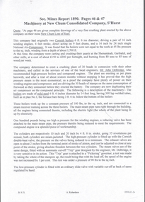
Plan - Lazarus Gold Mine, W.H. Cundy, Mining Engineer, Unknown
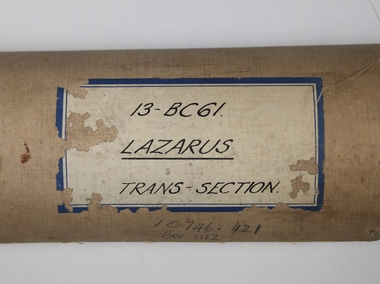
... See No. 3547, Bendigo Historical Society on Victoria Collections: https://victoriancollections.net.au/items/6684d58216337b271b28f843 ' Lazarus Mine', history of mine site by Albert Richardson. gold mining gold Margaret Roberts Collection Lazarus gold mine Thorpe's reef Shenandoah reef Old Chum Reef New Chum Reef Barnett Lazarus New Chum Hill New Chum Reef line W.H. Cundy Transverse section of Lazarus mine, showing the 'old shaft' and second shaft with poppet head. Old Chum, New Chum and Thorpe's Reef, Consolidated Reef and Shenandoah Reef are marked on plan ...The Lazarus New Chum Mining Company was first gazetted in 1871, with Barnett Lazarus the main shareholder with 20,000 shares. (Government Gazette 40 Page 956). The place of operation was 'New Chum'. See No. 3547, Bendigo Historical Society on Victoria Collections: https://victoriancollections.net.au/items/6684d58216337b271b28f843 ' Lazarus Mine', history of mine site by Albert Richardson. Transverse section of Lazarus mine, showing the 'old shaft' and second shaft with poppet head. Old Chum, New Chum and Thorpe's Reef, Consolidated Reef and Shenandoah Reef are marked on plan. Plan shows 40 levels in the Lazarusmine with a shaft depth of 3747 feet. On top right hand of plan: ' Transverse section of Lazarus mine, drawn by W.H. Cundy'. Mine plan is part of the Margaret Roberts Collection. gold mining, gold, margaret roberts collection, lazarus gold mine, thorpe's reef, shenandoah reef, old chum reef, new chum reef, barnett lazarus, new chum hill, new chum reef line, w.h. cundy -
 Bendigo Historical Society Inc.
Newspaper - Kangaroo Flat Gold Mine Collection: Victoria Hill
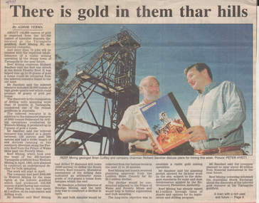
... Reef Mining Company Richard Sandner Brian Cuffley Bendigo Advertiser article, 4th March,1995, titled 'There is gold in them thar hills'. Reef Mining geologist Brian Cuffley and Company Chairman, Richard Sandner, are pictured discussing plans proposed for the Tarnagulla goldfield, where it is expected that '150,000 ounces of gold will be extracted from 527,000 tonnes of mineable deposits discovered at the Tarnagulla goldfield'. Colour photo shows Brian Cuffley and Richard Sandner, looking at a book titled 'Reef Mining, Tarnagulla Gold Field'. They are standing near a head frame. Newspaper Kangaroo Flat Gold Mine Collection: Victoria ...Bendigo Advertiser article, 4th March,1995, titled 'There is gold in them thar hills'. Reef Mining geologist Brian Cuffley and Company Chairman, Richard Sandner, are pictured discussing plans proposed for the Tarnagulla goldfield, where it is expected that '150,000 ounces of gold will be extracted from 527,000 tonnes of mineable deposits discovered at the Tarnagulla goldfield'. Colour photo shows Brian Cuffley and Richard Sandner, looking at a book titled 'Reef Mining, Tarnagulla Gold Field'. They are standing near a head frame.gold mining, bendigo, western mining, tarnagulla, reef mining company, richard sandner, brian cuffley -
Bendigo Historical Society Inc.
Map - SECTIONS ACROSS BENDIGO GOLDFIELD
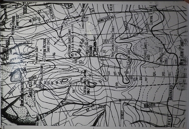
... Gold mining reef line maps Geological Survey of Victoria Map in three sections showing sections across Bendigo Gold Field, showing anticlines, synclines, faults, stratigraphical zones and mines along the reef lines. Key shows rock types Castlemaine, Bendigo B1, B2, B3 and B4, and Lancefieldian. First part of map shows sections A-A, B-B and C-C. Reef lines drawn with mines listed: Fault line shown are the Carshalton, Stafford, New Chum, Virginia and Clarence. A datum line shows 600 ft above sea level. On bottom of plan ...Map in three sections showing sections across Bendigo Gold Field, showing anticlines, synclines, faults, stratigraphical zones and mines along the reef lines. Key shows rock types Castlemaine, Bendigo B1, B2, B3 and B4, and Lancefieldian. First part of map shows sections A-A, B-B and C-C. Reef lines drawn with mines listed: Fault line shown are the Carshalton, Stafford, New Chum, Virginia and Clarence. A datum line shows 600 ft above sea level. On bottom of plan: ' Prepared in the Geological Survey Office, Bendigo, under the direction of H. Herman, late Director of Geological Survey, from surveys by H.S. Whitelaw, Field Geologist, assisted by E.S. Usher, A.J.J. Moore and R.A. Keble.' Second section of map shows sections D-D, and E-E. Fault lines listed are the Tambour Major fault, Carshalton fault, Stafford fault, Nell Gwynne fault, New Chum fault, Deborah fault. Third section shows sections F-F and G-G. Fault lines listed are the Bird Reef fault, Kangaroo Gully fault, Langdon fault, Carshalton fault, Nell Gwynne fault, Spring Gully fault, Hustlers fault, Gravel Hill fault, Ordes fault, Thanet fault. This map forms part of the Geological Survey of Victoria, Structure of Bendigo Goldfield report, No. 47, 1923. H.Herman, late Director of Geological Survey.Geological Survey of Victoriabendigo, gold mining, reef line maps -
 Bendigo Historical Society Inc.
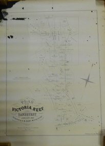
Document - MARKS COLLECTION: MAP OF VICTORIA REEF MINING CLAIMS
... Plan of the Victoria Reef Sandhurst January 1867, Compiled by G.W. Hart, Mining Surveyor. Published by John N. Macartney, Argus Agent, Sandhurst. Price 4/- each. On bottom Rh side J.W. Pearson & Co. Lith. Melbourne Plan shows mining claims and names of holders, scale (4 chains to one inch) Loddon Road, Mount Korong Road, Ironbark Gully, township of Long Gully, Quartz Miners' Arms and Gold Mines Hotel on Loddon Road....victoria reef plan Copy of map. On bottom LH side: Plan of the Victoria Reef Sandhurst January 1867, Compiled by G.W. Hart, Mining Surveyor. Published by John N. Macartney, Argus Agent, Sandhurst. Price 4/- each. On bottom Rh side J.W. Pearson & Co. Lith. Melbourne Plan shows mining claims and names of holders, scale (4 chains to one inch) Loddon Road, Mount Korong Road, Ironbark Gully, township of Long Gully, Quartz Miners' Arms and Gold Mines Hotel on Loddon Road. ...Copy of map. On bottom LH side: Plan of the Victoria Reef Sandhurst January 1867, Compiled by G.W. Hart, Mining Surveyor. Published by John N. Macartney, Argus Agent, Sandhurst. Price 4/- each. On bottom Rh side J.W. Pearson & Co. Lith. Melbourne Plan shows mining claims and names of holders, scale (4 chains to one inch) Loddon Road, Mount Korong Road, Ironbark Gully, township of Long Gully, Quartz Miners' Arms and Gold Mines Hotel on Loddon Road.bendigo, mining, victoria reef plan -
 Bendigo Historical Society Inc.
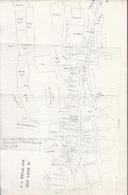
Map - BELLE VUE NO 2 - PLAN OF LEASES
... Victoria Reef G.M.Co South Adventure Co South Try Me Well W. Rae Wells Midway Extended Co Handy Andy Moonta Co Humboldt Co Adventure Co Try Me Well Sterry & Co Midway Tudor Friedman's Reef Rising Sun Try Me Luck Pomponia Confidence Co Alfred Co Advance Co Prince Alfred Co Canterbury Co Platus Co S. Platus Co Golden Fleece United Alfred Co Iron Duke Co Victoria Gold Mines Co Hercules Co Iron Bark Plan ...BHS CollectionPlan of Mining Leases from Rowan Street to Long Gully. Reference J. N. Macartney 2nd Edition Bendigo Goldfields Registry for 1872. Names of Leases are: Moore ?, Ellesmere Co, Bonati & Co, Dennis, Abe Lincoln Co, Lansell & Hunt, Black & White Lead Co, Koch & Hildebrand, Ballerstedt, Lazarus Co No 1, Lazarus Co, Watson, Lazarus Freehold, Lazarus Co No 2, Lazarus Tribute, South Extended Burra, Endeavor Co, Old Chum Co, Burrows and Sterry, New Chum & Victoria Trib, Jackson, North Old Wybrants Chum Co, Myra Co, McLenn, Geary & Co, Western Victoria Hill G. M. Co, Victoria Reef G.M.Co, South Adventure Co, South Try Me Well, W. Rae, Wells Midway, Extended Co, Handy Andy, Moonta Co, Humboldt Co, Adventure Co, Try Me Well, Sterry & Co, Midway, Tudor, Friedman's Reef, Rising Sun, Try Me Luck, Pomponia, Confidence Co, Alfred Co, Advance Co, Prince Alfred Co, Canterbury Co, Platus Co, S. Platus Co, Golden Fleece United, Alfred Co, Iron Duke Co, Victoria Gold Mines Co, Hercules Co and Iron Bark. Notes prepared by Albert Richardson.map, bendigo, mining plan, belle vue no 2, no 2 belle vue new chum & c, j n macartney bendigo goldfields registry 1872, moore ?, ellesmere co, bonati & co, dennis, abe lincoln co, lansell & hunt, black & white lead co, koch & hildebrand, ballerstedt, lazarus co no 1, lazarus co, watson, lazarus freehold, lazarus co no 2, lazarus tribute, south extended burra, endeavor co, old chum co, burrows and sterry, new chum & victoria trib, jackson, north old wybrants chum co, myra co, mclenn, geary & co, western victoria hill g. m. co, victoria reef g.m.co, south adventure co, south try me well, w. rae, wells midway, extended co, handy andy, moonta co, humboldt co, adventure co, try me well, sterry & co, midway, tudor, friedman's reef, rising sun, try me luck, pomponia, confidence co, alfred co, advance co, prince alfred co, canterbury co, platus co, s. platus co, golden fleece united, alfred co, iron duke co, victoria gold mines co, hercules co, iron bark -
 Bendigo Historical Society Inc.
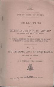
Book - MINING REPORTS - THE CONFIDENCE GROUP OF MINES BULLETIN NO 41
... Victoria issued by W Dickson, Secretary for Mines, Under the Authority of the Hon. S Barnes M L A Minister of Mines. No 41 The Confidence Group of Mines, Bendigo with Plans and Sections by H S Whitelaw, Field Geologist, dated 1918. Mines mentioned are: Confidence Extended Mine, Confidence Tribute Company and the Central Windmill Hill Mine. Mentioned in the report are crushings and gold yield, details of levels, names of leases along the reef...Victoria issued by W Dickson, Secretary for Mines, Under the Authority of the Hon. S Barnes M L A Minister of Mines. No 41 The Confidence Group of Mines, Bendigo with Plans and Sections by H S Whitelaw, Field Geologist, dated 1918. Mines mentioned are: Confidence Extended Mine, Confidence Tribute Company and the Central Windmill Hill Mine. Mentioned in the report are crushings and gold yield, details of levels, names of leases along the reef ...Light brown covered booklet 'Bulletins of the Geological Survey of Victoria issued by W Dickson, Secretary for Mines, Under the Authority of the Hon. S Barnes M L A Minister of Mines. No 41 The Confidence Group of Mines, Bendigo with Plans and Sections by H S Whitelaw, Field Geologist, dated 1918. Mines mentioned are: Confidence Extended Mine, Confidence Tribute Company and the Central Windmill Hill Mine. Mentioned in the report are crushings and gold yield, details of levels, names of leases along the reef. Extracts from Mine Manager's Half-yearly Reports, 1878-1915 of tons crushed and gold yield. Plans and sections of the Confidence Extended Mine on the Garden Gully Line of Reefs are: Plate I General Plan of All Levels, Plans of Levels Plate No II, Plans of Levels Plate No III, Transverse Section Plate No IV, Longitudinal Section Plate No V, and Central Windmill Hill Mine Transverse Section Plate No VI. Plates signed by H S Whitelaw 17 & 18/6/16 and 20/7/16. Booklet if part of the Albert Richardson Collection. book, bendigo, mining reports, mining reports, the confidence group of mines bulletin no 41, confidence extended mine, confidence tribute company, central windmill hill mine, department of mines, bulletins of the geological survey of victoria, w dickson, the hon s barnes, h s whitelaw, h j green, mr robert eddy, mr w h cundy, j foster, c j thompson -
 Bendigo Historical Society Inc.
Document - NEW CHUM & VICTORIA LINES OF REEF - NEW CHUM CONSOLIDATED COMPANY, S'HURST
... History House 11 Mackenzie Street Bendigo goldfields DOCUMENT Gold new chum & victoria lines of reef New Chum & Victoria Lines of Reef New Chum Consolidated Company S'hurst Shenandoah Garibaldi Mr John Delbridge Pearl Company Handwritten notes from Se? Mines Report Pages 46 & 47 on the Machinery at New Chum Consolidated Company, Sandhurst. Notes include boilers, Compressors, Battery and mentions plans ...Handwritten notes from Se? Mines Report Pages 46 & 47 on the Machinery at New Chum Consolidated Company, Sandhurst. Notes include boilers, Compressors, Battery and mentions plans. There are also descriptions of the machinery. A typed copy is also included.document, gold, new chum & victoria lines of reef, new chum & victoria lines of reef, new chum consolidated company s'hurst, shenandoah, garibaldi, mr john delbridge, pearl company -
 Bendigo Historical Society Inc.
Document - NEW CHUM LINE OF REEF - REFERENCE TO CALEB THOMAS PLANS
... New Franklin Murchison Catherine Reef United Catherine Reef (South) Acadia Catherine William's United York & Durham Belmont & Saxby Ellenborough Sadowa (old) St Mungo Lady Barkly Princess Alice (Sth St Mungo) Unicorn Trib Pheonix Hopewell United Devonshire (Princess Alex) West United Devonshire East United Devonshire Duchess of Edinburgh South Devonshire Duchess Tribute New St Mungo New St Mungo New Vict Catherine Gt Extd Vict Herc New Chum (Late Pearl) Pearl South North Herc & Energetic Herc & Energetic Ironbark Vict Consols South New Chum Lansell's 616 South Belle Vue Eureka Extd New Chum Rly South Old Chum New Chum Consolidated Ellesmere (South Shaft) Garibaldi Cravens Young Chum Ellesmere Nth Shaft New Chum United New Chum Vic Old Chum Lazarus Cent New Chum Lansell's 222 North Old Chum Lansell's Big 180 Advents Advance Gt Cent Vict Hamboldt Ballerstedt Victoria Quartz Herc & Energetic Herc (Old) Shenandoah Victoria Reef Gold Victoria Consols Five pages (typed copy of Albert Richardson original) of reference numbers used on Caleb Thomas plans. The mine's ...Five pages (typed copy of Albert Richardson original) of reference numbers used on Caleb Thomas plans. The mine's name, size of shaft and on other pages, the height of the sill. document, gold, mines, new chum line of reef, reference to caleb thomas plans, catherine reef extd., new franklin, murchison, catherine reef united, catherine reef (south), acadia catherine, william's united, york & durham, belmont & saxby, ellenborough, sadowa, (old) st mungo, lady barkly, princess alice (sth st mungo), unicorn trib, pheonix, hopewell, united devonshire (princess alex), west united devonshire, east united devonshire, duchess of edinburgh, south devonshire, duchess tribute, new st mungo, new st mungo, new vict catherine, gt extd vict, herc new chum (late pearl), pearl south, north herc & energetic, herc & energetic, ironbark, vict consols, south new chum, lansell's 616, south belle vue, eureka extd, new chum rly, south old chum, new chum consolidated, ellesmere (south shaft), garibaldi, cravens, young chum, ellesmere nth shaft, new chum united, new chum vic, old chum, lazarus, cent new chum, lansell's 222, north old chum, lansell's big 180, advents advance, gt cent vict, hamboldt, ballerstedt, victoria quartz, herc & energetic, herc (old), shenandoah, victoria reef gold, victoria consols -
 Bendigo Historical Society Inc.
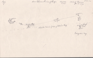
Document - NEW CHUM LINE OF REEF - PART OF A PLAN OF MINES ALONG THE NEW CHUM LINE OF REEF
... History House 11 Mackenzie Street Bendigo goldfields DOCUMENT Gold New Chum Line Of Reef Part of a plan of mines along the New Chum Line Of Reef Caleb Thomas Hercules Mine Energetic Mine Energetic Coy Sketch of mines along the New Chum Line of Reef Sheet No 1 (811) Caleb Thomas Jun 28, 1879. Mines mentioned are the Hercules and the Energetic. The others are shaft numbers. Measurements between each in feet and yards. Probable course of cap of Victoria ...Sketch of mines along the New Chum Line of Reef Sheet No 1 (811) Caleb Thomas Jun 28, 1879. Mines mentioned are the Hercules and the Energetic. The others are shaft numbers. Measurements between each in feet and yards. Probable course of cap of Victoria Reef drawn in.document, gold, new chum line of reef, part of a plan of mines along the new chum line of reef, caleb thomas, hercules mine, energetic mine, energetic coy -
 Bendigo Historical Society Inc.
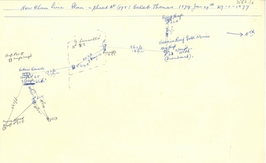
Document - NEW CHUM LINE OF REEF - PLAN OF MINES ALONG PART OF THE NEW CHUM LINE OF REEF
... Gold...New Chum Line Of Reef... Plan of Mines along part of the New Chum Line Of Reef... Caleb Thomas... Prince Alfred Mine... Victoria...History House 11 Mackenzie Street Bendigo goldfields DOCUMENT Gold New Chum Line Of Reef Plan of Mines along part of the New Chum Line Of Reef Caleb Thomas Prince Alfred Mine Victoria Consols G Lansell's No 83 Ironbark Victoria Reef Gold Mines Sketch of some mines along the New Chum Line of Reef. ...Sketch of some mines along the New Chum Line of Reef. Sheet No (178) Caleb Thomas 1879 Jan 29th. Mines mentioned are: Prince Alfred, Victoria Consols, G Lansell's No 83. Some mines are only a number. Victoria Reef Gold Mines are mentioned. Distances in feet or yards between them.document, gold, new chum line of reef, plan of mines along part of the new chum line of reef, caleb thomas, prince alfred mine, victoria consols, g lansell's no 83, ironbark, victoria reef gold mines -
 Bendigo Historical Society Inc.
Document - NEW CHUM LINE OF REEF - REFERENCE FOR CALEB THOMAS PLANS
... History House 11 Mackenzie Street Bendigo goldfields DOCUMENT Gold New Chum Line of Reef Reference for Caleb Thomas Plans New Chum Bellevue & Railway Reserve Bellevue & New Chum Shenandoah Shamrock Old Chum Little Chum New Chum Trib Young Chum Cravens Garibaldi No 1 Ellesmere Coy New Chum Consolidated Ellesmere New Chum United Lansell's 222 (denis) Lansell's 222 (New Shaft) Koch & Hildebrandt (Lansell's 222) Lazarus Co Sheer Legs Old Chum New Chum & Victoria North Old Chum Lansell's 180 Victoria Quartz Gt Cent Vic Victoria Consols Victoria Reef Co (Ironbark) Hercules Energetic Ladder Shaft Energetic Shaft Two handwritten pages of reference numbers for Caleb Thomas plans. The numbers refer to mines ...Two handwritten pages of reference numbers for Caleb Thomas plans. The numbers refer to mines on the New Chum Line of Reef.document, gold, new chum line of reef, reference for caleb thomas plans, new chum bellevue & railway reserve, bellevue & new chum, shenandoah, shamrock, old chum, little chum, new chum trib, young chum, cravens, garibaldi, no 1 ellesmere coy, new chum consolidated, ellesmere, new chum united, lansell's 222 (denis), lansell's 222 (new shaft), koch & hildebrandt (lansell's 222), lazarus co, sheer legs, old chum, new chum & victoria, north old chum, lansell's 180, victoria quartz, gt cent vic, victoria consols, victoria reef co (ironbark), hercules, energetic ladder shaft, energetic shaft -
 Bendigo Historical Society Inc.
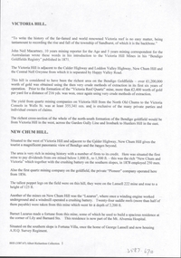
Document - VICTORIA HILL - PLAN OF THE VICTORIA REEF GOLD MINES COMPANY
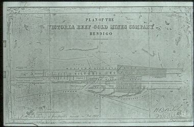
... Plan of the Victoria Reef Gold Mines Company, Bendigo showing the Eastern Victoria Reef, Victoria Reef and the Western Victoria Reef. ...Co and Wheadon Plan of the Victoria Reef Gold Mines Company, Bendigo showing the Eastern Victoria Reef, Victoria Reef and the Western Victoria Reef. ...Plan of the Victoria Reef Gold Mines Company, Bendigo showing the Eastern Victoria Reef, Victoria Reef and the Western Victoria Reef. Streets, gullies and leases drawn in. Some amounts of money and names have been written on the page. Signed by H. B. Nicholas. Locations of Ballerstedt's, Luffsman's, Wittscheibe's, Midway Co and Rae's engines are shown. Ironbark, Derwent, Providence and Long Gullies are shown. Also Mount Korong Road. Leases mentioned are: Jackson, Burrows, Wybarndt, Ballerstedt, Luffsman, Roberts, Ashley, Grant, Troy, Tezeau, Woodward, Croath, Taylor, Cranshaw, Gou?d & Co, Midway, Wittscheibe, Specimen Hill Co, Endeavour, Albert Co, Ballerstedt & Son, Hy? Co, and Wheadon.document, gold, victoria hill, plan of the victoria reef gold mines company, h b nicholas, spiers, jackson, burrows, wybarndt, ballerstedt, luffsman, roberts, ashley, grant, troy, tezeau, woodward, croath, taylor, cranshaw, gou?d & co, midway, wittscheibe, specimen hill co, endeavour, albert co, ballerstedt & son, hy? co, and wheadon -
 Bendigo Historical Society Inc.
Document - VICTORIA HILL - PLAN OF THE VICTORIA REEF GOLD MINES COMPANY BENDIGO
... History House 11 Mackenzie Street Bendigo goldfields MAP Bendigo Victoria Hill Plan of the Victoria Reef Gold Mines Company Bendigo 3587.70 same as 3587.69. ...3587.70 same as 3587.69. Copied onto smaller white paper.map, bendigo, victoria hill, plan of the victoria reef gold mines company bendigo -
 Bendigo Historical Society Inc.
Document - VICTORIA HILL - VICTORIA HILL AND NEW CHUM HILL
... Victoria Reef Quartz Mine North Old Chum Victoria Consols New Chum and Victoria Pioneer Lansell 222 Mine Lazarus Barnet Lazarus Mt. Alvernia Hospital Fortuna Villa George Lansell A. H. Q. survey Regiment Central Red White and Blue Hudsons Burrowes & Sterry B C V Channel 8 Bendigo and District Tourist Association Section 14 of the Lands Act 1958 Mr A R Richardson Cr T R Flood Tourist Association Typed notes on Victoria Hill and New Chum Hill. Notes give location, value of gold and plans ...Typed notes on Victoria Hill and New Chum Hill. Notes give location, value of gold and plans for a mining museum.document, gold, victoria hill, victoria hill and new chum hill, john neil macartney, the age, the australasian, bendigo goldfields registry 1871, victoria reef quartz mine, north old chum, victoria consols, new chum and victoria, pioneer, lansell 222 mine, lazarus, barnet lazarus, mt. alvernia hospital, fortuna villa, george lansell, a. h. q. survey regiment, central red white and blue, hudsons, burrowes & sterry, b c v channel 8, bendigo and district tourist association, section 14 of the lands act 1958, mr a r richardson, cr t r flood, tourist association -
 Bendigo Historical Society Inc.
Map - UNITED HUSTLER'S & REDAN & K. K. MINES - PLAN OF THE UNITED HUSTLER'S & REDAN & K. K. MINES
... Mines Geological Survey of Victoria H S Whitelaw Underground Survey Office Bendigo Plan of the United Hustler's & Redan & K. K. Mines Bulletin No 33 Plate No XXXI. Shows depth of levels, Probable positions of reefs and natural surface with the poppet legs at the two shafts. Sill of shaft of the K. K. Mine 773.56 ft above Sea Level and sill of shaft of the United Hustler's & Redan Mine 745.62 above Sea Level. Also mentioned is the average amount of gold ...Plan of the United Hustler's & Redan & K. K. Mines Bulletin No 33 Plate No XXXI. Shows depth of levels, Probable positions of reefs and natural surface with the poppet legs at the two shafts. Sill of shaft of the K. K. Mine 773.56 ft above Sea Level and sill of shaft of the United Hustler's & Redan Mine 745.62 above Sea Level. Also mentioned is the average amount of gold obtained per ton. Note on the top of page - Plates 4, 8, 13, 20, 26 & 31 form a Longitudinal Section from Fortuna Hustler's to Hustler's Consols Mine. Geological Survey of Victoria emblem and signed by H S Whitelaw, Underground Survey Office, Bendigo, September 1913. mining, parish map, united hustler's & redan & k. k. mines, geological survey of victoria, h s whitelaw, underground survey office bendigo -
 Bendigo Historical Society Inc.
Map - DEPARTMENT OF MINES VICTORIA : PLAN SHOWING PORTION OF THE BENDIGO GOLD FIELD
... Mines Victoria. Plan showing portion of the Bendigo Gold Field. On the back is written, in ink, J. J. Tyler 1937 Northern Area. (He was a teacher at Bendigo High - see donation notes). Across the bottom of the map is written ' M. Hill cr. Myrtle & Barnard' .The named reef...Gold Mining. Tyler J. J. Department of Mines Victoria. Plan showing portion of the Bendigo Gold Field. On the back is written, in ink, J. J. Tyler 1937 Northern Area. (He was a teacher at Bendigo High - see donation notes). Across the bottom of the map is written ' M. Hill cr. Myrtle & Barnard' .The named reef ...Department of Mines Victoria. Plan showing portion of the Bendigo Gold Field. On the back is written, in ink, J. J. Tyler 1937 Northern Area. (He was a teacher at Bendigo High - see donation notes). Across the bottom of the map is written ' M. Hill cr. Myrtle & Barnard' .The named reef lines have been numbered with ink across the bottom of the map. The gullies have been coloured with green pencil and a red pencil line is drawn through the western side of the map. Additional information: anticlinal axial lines at surface, alluvial workings, shaft sites, area of Main Goldfield, Deepest mine workings, Gold output of field to 1935, and Dividends paid 1870 - 1935.bendigo, gold mining, bendigo gold field. gold mining. tyler, j. j. -
 Bendigo Historical Society Inc.
Document - MINING IN BENDIGO COLLECTION: NAMES OF MINING SLIDES
... Gold...mining in bendigo...Mining in Bendigo... Names of Mining Slides... Bob Aulsbrook... Ian Hendry... New Chum Railway... Healthy Golden Bendigo... Lansells 222... Lansell's Fortuna... Old Chum Mine... from New Chum Hill... to Victoria Hill... Plan of leases on Victoria Hill 1859... Lansell's Big 180... Bendigo & Vicinity... Victoria Quartz... Wm Rae's crushing Machine... Hercules & Energetic... Mungo Mines... United Devonshire... Mungo Group & Devonshire Mines 1888... Catherine Reef...History House 11 Mackenzie Street Bendigo goldfields BHS Collection DOCUMENT Gold mining in bendigo Mining in Bendigo Names of Mining Slides Bob Aulsbrook Ian Hendry New Chum Railway Healthy Golden Bendigo Lansells 222 Lansell's Fortuna Old Chum Mine from New Chum Hill to Victoria Hill Plan of leases on Victoria Hill 1859 Lansell's Big 180 Bendigo & Vicinity Victoria Quartz Wm Rae's crushing Machine Hercules & Energetic Mungo Mines United Devonshire Mungo Group & Devonshire Mines 1888 Catherine Reef United Garden Gully United Knipe;s Castle Old Carlisle Nth Garden & Passby Koch's Pioneer Quartz Crushing Battery Great Northern Mine Virginia Mine Specimen Hill New Argus South New Moon New Moon Big Blue Mine Eadie's Whim & Central Blue Mine Fortuna Hustlers Pictorial Photos of Victorian Views Hustler's Royal Reserve Mine - City Extended Hustler's Freehold - looking South Great Extended Hustlers Hustlers Reef Mine Central Nell Gwynne Cornish Boiler Lancashire Boiler Wannan's E'Drivers Guide Winding Engine - New Moon 20 Drill Air Compressor - New Moon 1904 Engine at Virginia Crushing Battery Lansell's 105 Head Crushing Battery Deeble's Pyrites Works Miner at Central Deborah Level at 1045 feet at New Moon Boring on a reef at Catherine Reef Deborah Mine 1000 ft level Mines Dep't Melb & Bendigo Engine beds Lansell's Big 180 New Hustlers Rae's Open Cut Ballerstedt's First Open Cut 3 of Early days of Bendigo Geo Lansell Typed copy and two handwritten copies of index to mining slides per Bob Aulsbrook, 30.12.69 and Ian Hendry. ...BHS CollectionTyped copy and two handwritten copies of index to mining slides per Bob Aulsbrook, 30.12.69 and Ian Hendry.document, gold, mining in bendigo, mining in bendigo, names of mining slides, bob aulsbrook, ian hendry, new chum railway, healthy golden bendigo, lansells 222, lansell's fortuna, old chum mine, from new chum hill, to victoria hill, plan of leases on victoria hill 1859, lansell's big 180, bendigo & vicinity, victoria quartz, wm rae's crushing machine, hercules & energetic, mungo mines, united devonshire, mungo group & devonshire mines 1888, catherine reef united, garden gully united, knipe;s castle, old carlisle, nth garden & passby, koch's pioneer quartz crushing battery, great northern mine, virginia mine, specimen hill, new argus, south new moon, new moon, big blue mine, eadie's whim & central blue mine, fortuna hustlers, pictorial photos of victorian views, hustler's royal reserve mine - city, extended hustler's freehold - looking south, great extended hustlers, hustlers reef mine, central nell gwynne, cornish boiler, lancashire boiler, wannan's e'drivers guide, winding engine - new moon, 20 drill air compressor - new moon 1904, engine at virginia crushing battery, lansell's 105 head crushing battery, deeble's pyrites works, miner at central deborah, level at 1045 feet at new moon, boring on a reef at catherine reef, deborah mine 1000 ft level, mines dep't melb & bendigo, engine beds lansell's big 180, new hustlers, rae's open cut, ballerstedt's first open cut, 3 of early days of bendigo, geo lansell -
 Federation University Historical Collection
Map, Ballaarat Gold Field, 1861, 1861
... Victoria Theatre Charlie Napier Hotel United States Hotel Grape's Hoel Clayton's Hill Cattleyard Hill Free Trade Hotel Esmond Lead Bakery Hill Black Hill Lead Juvenile Reformatory Ballarat Orphanage Lady Barkly Lead Triffet's Slaughter Yard Little Bendigo Melbourne Road T. Cowan Thomas Cowan "Compiled & Drawn from the Survey of Mining Surveyors Davidson, Fitzpatrick and Cowan & the Plans in the Surveyor General's Office by J. Brahe, 21st October 1861. R. Brough Smyth, Secretary for Mines. The Honourable J.B. Humffray, M.L.A. Commr of Mines.” Original 1861 map of Ballarat showing streets and leads. Blue dots indicate gold leads, and red lines indicate auriferous quartz reef ...A party of surveyors camped by Yuille's Swamp (later Lake Wendouree) and surveyed the countryside for a map to be produced by the Geological Survey of Victoria. In November 2004 the Central Highlands Regional Library presented a special edition of 200 copies of the 1861 map reproduced from a copy in their collection. Original 1861 map of Ballarat showing streets and leads. Blue dots indicate gold leads, and red lines indicate auriferous quartz reef and outcrops of quartz veins."Compiled & Drawn from the Survey of Mining Surveyors Davidson, Fitzpatrick and Cowan & the Plans in the Surveyor General's Office by J. Brahe, 21st October 1861. R. Brough Smyth, Secretary for Mines. The Honourable J.B. Humffray, M.L.A. Commr of Mines.”ballarat, map, ballarat east, lake wendouree, survey, mines, robert davidson, ballarat gold field 1861, yuille's swamp, wendouree swamp, little bendigo diggings, gold leads, old post office hill, specimen hill, bakery hill, black hill, dead horse creek, brown hill, pennyweight hill, clayton hill, soldiers hill, golden point, gum tree flat, white flat, poverty hill, chinese village, robert brough smyth, ballarat map 1861, ballaarat vineyard, dead horse gully, deadhorse creek, invermay, black hill flat, gaelic church, police reserve, magpie range, dalton's flat, caadian lead, rifle butts, powder magazine, bathing house, government camp, gold office, chinese, llanberrris, victoria theatre, charlie napier hotel, united states hotel, grape's hoel, clayton's hill, cattleyard hill, free trade hotel, esmond lead, bakery hill, black hill lead, juvenile reformatory, ballarat orphanage, lady barkly lead, triffet's slaughter yard, little bendigo, melbourne road, t. cowan, thomas cowan -
 Federation University Historical Collection
Book, Memoirs of the Geological Survey of Victoria No 14 The Ballarat Goldfields, 1923, 1923
... plans by William Baragwanath. Contents include topography, physiography, historical, geology, basalt, faults, dykes, minerals leads, alluvial mines, nuggets, structure of Ballarat West goldfields, structure of Ballarat East gold-field, quartz formation, indicators, defunct mines, existing mines, table of deepest shafts. Images include: section of the Ballarat Gold-Field, Dead HOrse Flat, lakes formed by Basalt Flows, Gong Gong Creek, Frenchman's Lead, Ballarat West Mines, LEases and positions of shafts (1857), puddling, White Horse Lead, Woah Hawp Canton, Ballarat Township mines, Sebastopol, syncline, Victoria United Line, First Chance Mine, Llanberris No 1 Mine, Saddle Reef, New Normanby Mine, Woah Hawp Canton Mine, South Star Mine, Sebastopol Plateau, south Woah Hawp Mine, Woah No. 2 Mine...plans by William Baragwanath. Contents include topography, physiography, historical, geology, basalt, faults, dykes, minerals leads, alluvial mines, nuggets, structure of Ballarat West goldfields, structure of Ballarat East gold-field, quartz formation, indicators, defunct mines, existing mines, table of deepest shafts. Images include: section of the Ballarat Gold-Field, Dead HOrse Flat, lakes formed by Basalt Flows, Gong Gong Creek, Frenchman's Lead, Ballarat West Mines, LEases and positions of shafts (1857), puddling, White Horse Lead, Woah Hawp Canton, Ballarat Township mines, Sebastopol, syncline, Victoria United Line, First Chance Mine, Llanberris No 1 Mine, Saddle Reef, New Normanby Mine, Woah Hawp Canton Mine, South Star Mine, Sebastopol Plateau, south Woah Hawp Mine, Woah No. 2 Mine Memoirs of the Geological Survey of Victoria No 14 The Ballarat Goldfields, 1923 Book Book ...William Baragwanath was educated at the Ballarat School of Mines, obtaining a Geology Certificate in 1911. After further study he went on the become Secretary for Mines, and Chief Mining Surveyor. Baragwanath was a Councillor of the Ballarat School of Mine from 1916 to 1950.Pink covered foolscap book of 257 pages and 32 maps and plans by William Baragwanath. Contents include topography, physiography, historical, geology, basalt, faults, dykes, minerals leads, alluvial mines, nuggets, structure of Ballarat West goldfields, structure of Ballarat East gold-field, quartz formation, indicators, defunct mines, existing mines, table of deepest shafts. Images include: section of the Ballarat Gold-Field, Dead HOrse Flat, lakes formed by Basalt Flows, Gong Gong Creek, Frenchman's Lead, Ballarat West Mines, LEases and positions of shafts (1857), puddling, White Horse Lead, Woah Hawp Canton, Ballarat Township mines, Sebastopol, syncline, Victoria United Line, First Chance Mine, Llanberris No 1 Mine, Saddle Reef, New Normanby Mine, Woah Hawp Canton Mine, South Star Mine, Sebastopol Plateau, south Woah Hawp Mine, Woah No. 2 Minegeology, geological survey no 14, ballarat, baragwanath, william baragwanath -
 Rutherglen Historical Society
Map, 1908
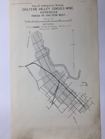
... Mining map of one of the first mines in Rutherglen area ( Chiltern West) Gold Rutherglen Mining Chiltern Underground Mine Map Geological Survey Reef Drives Geographical Survey of Victoria, Memoir, No6. Plate XX Plan ...This is a map produced as part of a book entitled.. It is also stamped on the back in blue ink with an oval ring and the words North of England Institute. Newcastle. Mining & Meterolgical Faculty. Purchased on 23rd July 2017 by the Society after research by member Simon Killeen. Mining map of one of the first mines in Rutherglen area ( Chiltern West)Cream paper, black printing, rectangle with a drawingGeographical Survey of Victoria, Memoir, No6. Plate XX Plan of Underground Workings CHILTERN VALLEY CONSOLS MINE, RUTHERGLEN, PARISH OF CHILTERN WESTgold, rutherglen, mining, chiltern, underground mine map, geological survey, reef drives -
Tarnagulla History Archive
Set of Maps (Mining & Local Area), various
... plans: 1. Dunolly Deep Leads - showing location and names of deep lead gold deposits in region around Dunolly including at Tarnagulla and Newbridge. Geological Survey of Victoria, Department of Minerals and Energy. Bulletin No. 62, Map No. 4 Dunolly (770 x 485 mm). 2. Poseidon Lead (Facsimile) 3. Nick O Time Lead (Facsimile) 4. Happy Go Lucky Mine prospectus and plan (colour copy) 5. Jones Creek GM Co. (Raven & Gourlay's) Waanyarra - Prospectus (colour copy) 6. Poseidon Area Plan (colour copy) and Poseidon Area map (B&W copy). 7. Cross-section diagram of Spread Eagle Reef...plans: 1. Dunolly Deep Leads - showing location and names of deep lead gold deposits in region around Dunolly including at Tarnagulla and Newbridge. Geological Survey of Victoria, Department of Minerals and Energy. Bulletin No. 62, Map No. 4 Dunolly (770 x 485 mm). 2. Poseidon Lead (Facsimile) 3. Nick O Time Lead (Facsimile) 4. Happy Go Lucky Mine prospectus and plan (colour copy) 5. Jones Creek GM Co. (Raven & Gourlay's) Waanyarra - Prospectus (colour copy) 6. Poseidon Area Plan (colour copy) and Poseidon Area map (B&W copy). 7. Cross-section diagram of Spread Eagle Reef ...David Gordon Collection. A set of mining documents, maps and plans: 1. Dunolly Deep Leads - showing location and names of deep lead gold deposits in region around Dunolly including at Tarnagulla and Newbridge. Geological Survey of Victoria, Department of Minerals and Energy. Bulletin No. 62, Map No. 4 Dunolly (770 x 485 mm). 2. Poseidon Lead (Facsimile) 3. Nick O Time Lead (Facsimile) 4. Happy Go Lucky Mine prospectus and plan (colour copy) 5. Jones Creek GM Co. (Raven & Gourlay's) Waanyarra - Prospectus (colour copy) 6. Poseidon Area Plan (colour copy) and Poseidon Area map (B&W copy). 7. Cross-section diagram of Spread Eagle Reef 8. New Birthday Gold Mine - area map (colour copy) and mine cross-section ( (colour copy). 9. Cross section of Poverty Reef, by Department of Mines (B&W copy, 2 parts on A2 paper) 10. Time-Lease Graph for Watts Reef, Specimen Reef, Stony Reef, Poverty Reef (second page in detail), created by Eric WIlkinson for Ref Mining NL, 1995 11. 1859 Plan of the Gold Workings & Township of Sandy Creek, Shewing the Mining Leases, Extended Claims & Machinery by R.J. McMillan, Mining Surveyor (B&W copy) 12. Longitundinal and Transverse Vertical Sections of Poverty Reef, Sandy Creek 1859, by R.J. McMillan, Mining Surveyor (B&W copy) 13. Tarnagulla Locality Plan (B&W copy) 14. Universal Grid Reference Map (Topographic) for Laanecoorie North (2 copies) 15. Universal Grid Reference Map (Topographic) for Inglewood South 16. Poverty Reef, Plan showing shafts and early tenements, created by Eric WIlkinson for Ref Mining NL, 1995 17. Locality Map of mining leases in Tarnagulla 18. Plan and Elevation of part of Poverty Reef, Sandy Creek, showing the claims and positions of the shaft. by R.J. McMillan, Mining Surveyor (Facsimile, composed of taped together components) 19.Plan and Elevation of part of Poverty Reef, Sandy Creek, showing the claims and positions of the shaft. by R.J. McMillan, Mining Surveyor (Facsimile, composed of taped together components) -
 Bendigo Historical Society Inc.
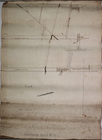
Plan - Victoria Reef Gold Mine Trans Section
... Hand drawn plan of Victoria Reef Gold Mine, trans section. Written on bottom of plan: Victoria Reef G.M.C. ... Hand drawn plan of Victoria Reef Gold Mine, trans section. Written on bottom of plan: Victoria Reef G.M.C. ...Victoria Reef Gold Mine was situated near the intersection of Hercules and Syncline Court, Long Gully.Hand drawn plan of Victoria Reef Gold Mine, trans section. Written on bottom of plan: Victoria Reef G.M.C. Handwritten annotations on section of plan. Plan forms part of the Margaret Roberts Collection.J. Sheard, 189 View Street, Bendigo' written on plangold mining, gold, victoria reef, trans section, bendigo, quartz mining -
 Bendigo Historical Society Inc.
Plan - New Chum and Victoria Lease
... reef mining with some of the richest mines of the field, led by George Lansell and Daniel Barnet Lazarus. These included the nearby mine sites of New Chum and Victoria, New Chum United, Old Chum, Lansells 222 and Lazarus as well as operating extensive battery buildings and pyrites works that were all located in New Chum Gully between Booth, Thistle Streets and Maple Street. (City of Greater Bendigo, Heritage Report, 27 Pallett Street, Golden Square) Margaret Roberts gold gold mine New Chum and Victoria Lease Victoria Hill Bendigo New Chum and Victoria Lease plan ...New Chum Gully is one of the earliest and most important alluvial and quartz mining gully of Bendigo goldfields. It was also one of the more lucrative reefs and became the site of extensive quartz reef mining with some of the richest mines of the field, led by George Lansell and Daniel Barnet Lazarus. These included the nearby mine sites of New Chum and Victoria, New Chum United, Old Chum, Lansells 222 and Lazarus as well as operating extensive battery buildings and pyrites works that were all located in New Chum Gully between Booth, Thistle Streets and Maple Street. (City of Greater Bendigo, Heritage Report, 27 Pallett Street, Golden Square)New Chum and Victoria Lease plan. Written on outside of plan: ' Western Portion, New Chum and Victoria Lease, 2 chains to an inch'. Plan forms part of the Margaret Roberts Collection of mining records. margaret roberts, gold, gold mine, new chum and victoria lease, victoria hill, bendigo -
 Bendigo Historical Society Inc.
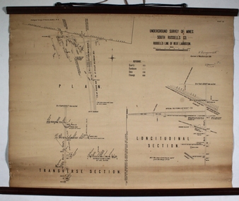
Plan - South Russell's Co Mine
... Margaret Roberts gold gold mine Bendigo South Russell's Co Mine Printed on top of plan: 'Underground Survey of Mines, South Russell's Co Mine, Russell's Line of Reef, Lauriston'. Plan shows transverse and longitudinal sections. Underneath title, signature of'W. Baragwanath. Printed: Department of Mines, Victoria ...Printed on top of plan: 'Underground Survey of Mines, South Russell's Co Mine, Russell's Line of Reef, Lauriston'. Plan shows transverse and longitudinal sections. Underneath title, signature of'W. Baragwanath. Printed: Department of Mines, Victoria, 1906. In cursive below: ' E.J. Dunn, 6.4.06' Plan forms part of the Margaret Roberts Collection of mining records. margaret roberts, gold, gold mine, bendigo, south russell's co mine