Showing 68 items matching "victoria reef plan"
-
 Bendigo Historical Society Inc.
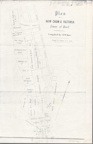
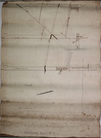
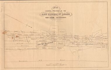
Map - NEW CHUM & VICTORIA LINES OF REEF - PLAN OF NEW CHUM & VICTORIA LINES OF REEF
... NEW CHUM & VICTORIA LINES OF REEF - PLAN OF NEW CHUM & VICTORIA LINES OF REEF...Two pages of a Plan of New Chum & Victoria Lines of Reef, compiled by G. W. ...Plan shows leases from High Street to California Gully. Location of the Manchester Arms, British & American Hotel and the Quartz Miners Arms are shown. Townships of Long Gully and Ironbark are shown. Map NEW CHUM & VICTORIA LINES OF REEF ...Two pages of a Plan of New Chum & Victoria Lines of Reef, compiled by G. W. Hart. Taken from J. N. Macartney's G'Fields Registry for 1871. Plan shows leases from High Street to California Gully. Location of the Manchester Arms, British & American Hotel and the Quartz Miners Arms are shown. Townships of Long Gully and Ironbark are shown.map, goldfields, new chum & victoria lines of reef, victoria catharine g m coy, thornton & co, extd victoria reef g m co, ural tribute compy, nil desperandum compy, koch, north victoria g m co, danger hill coy, north endeavour coy, wheadon & co, pilot co, north energetic co, energetic compy, endeavour company, hercules co, victoria gold mines compy, iron duke g m co, golden fleece united, ballerstedt, alfred co, confidence co, prince alfred co, canterbury co, advance co, wells, humboldt co, adventure co, try me well, sterry & co, gibbs & ballerstedt, handy andy, wells?, south adventure co, w rae, victoria reef quartz m co, myra co, jackson, wybrants, burrows & sterry, new chum & victoria tribute, old chum co, ballerstedt, lazarus, watson, koch & hildebrand, lansell & hunt, dennis, abe lincoln co, bonati & co, ellesmere co, moore late menzies, british co, british tribute co, garibaldi, c c co, new chum trib, dobson & co, young chum co, little chum co, old chum co, new chum trib, little chum trib, g w hart, j n macartney's g'fields registry for 1871, manchester arms, british & american, quartz miners arms -
 Bendigo Historical Society Inc.
Document - MARKS COLLECTION: MAP OF VICTORIA REEF MINING CLAIMS
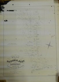
... ...victoria reef plan...On bottom LH side: Plan of the Victoria Reef Sandhurst January 1867, Compiled by G.W. ...History House 11 Mackenzie Street Bendigo goldfields BENDIGO Mining victoria reef plan Copy of map. On bottom LH side: Plan of the Victoria Reef Sandhurst January 1867, Compiled by G.W. ...Copy of map. On bottom LH side: Plan of the Victoria Reef Sandhurst January 1867, Compiled by G.W. Hart, Mining Surveyor. Published by John N. Macartney, Argus Agent, Sandhurst. Price 4/- each. On bottom Rh side J.W. Pearson & Co. Lith. Melbourne Plan shows mining claims and names of holders, scale (4 chains to one inch) Loddon Road, Mount Korong Road, Ironbark Gully, township of Long Gully, Quartz Miners' Arms and Gold Mines Hotel on Loddon Road.bendigo, mining, victoria reef plan -
 Bendigo Historical Society Inc.
Slide - ALBERT RICHARDSON COLLECTION: PLAN OF LEASES VICTORIA HILL
... ...victoria reef gold mines plan....Victoria Reef Gold Mines Company Mining Plan. Mount Korong Road on bottom of plan, Victoria Reef running through centre....History House 11 Mackenzie Street Bendigo goldfields MINE Gold victoria reef gold mines plan. BENDIGO MINES-JACK HATTAM COLLECTION Slide. . ...Slide. . Victoria Reef Gold Mines Company Mining Plan. Mount Korong Road on bottom of plan, Victoria Reef running through centre.mine, gold, victoria reef gold mines plan., bendigo mines-jack hattam collection -
 Bendigo Historical Society Inc.
Plan - Victoria Quartz Gold Mine, Unknown
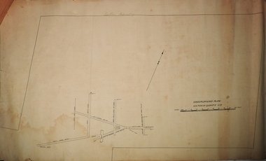
... Written on accompanying label: "Victoria Reef, underground plan'. Plan shows shaft, drives and geological features. ...The mine closed in 1913, having produced over 48,000 ounces of gold and paid dividends of £99,600. gold mining gold Bendigo Victoria Quartz Gold Mine Victoria Reef Printed in black text on light tan paper: 'Underground workings, Victoria Quartz Co''. Written on accompanying label: "Victoria Reef, underground plan'. ...Victoria Quartz Gold Mine was situated on Victoria Hill, Bendigo. Victoria Hill is situated on the Marong Road, opposite the Gold Mines Hotel. Victoria Hill was one of the richest areas on the Bendigo Goldfield. It had many successful mines, including Lansell's '180' and the Victoria Quartz, once the deepest gold mine in the world. At the turn of the century, this was the site of one of the premier mines on the Bendigo goldfield. In 1908, it boasted the world's deepest shaft - 4,478 feet (1,365 metres). The shaft reached a depth of 4,613 feet (1,406 metres) in 1910. In 1857 eight small claims in this area had been merged to form the Victoria Reef Quartz Mining Co. Another merger in 1877 led to the formation of the Victoria Quartz Co. For the next three decades, the mine produced consistent profits. In 1910, water burst into the claim, flooding the shaft and halting operations. The company baled water for six months then handed the mine over to the tributers who worked the upper levels for the share of the profits. The mine closed in 1913, having produced over 48,000 ounces of gold and paid dividends of £99,600.Printed in black text on light tan paper: 'Underground workings, Victoria Quartz Co''. Written on accompanying label: "Victoria Reef, underground plan'. Plan shows shaft, drives and geological features. Plan forms part of the Margaret Roberts Collection.gold mining, gold, bendigo, victoria quartz gold mine, victoria reef -
 Bendigo Historical Society Inc.
Plan - Victoria Reef Gold Mine Trans Section
... Hand drawn plan of Victoria Reef Gold Mine, trans section. Written on bottom of plan: Victoria Reef G.M.C. ... Hand drawn plan of Victoria Reef Gold Mine, trans section. Written on bottom of plan: Victoria Reef G.M.C. ...Victoria Reef Gold Mine was situated near the intersection of Hercules and Syncline Court, Long Gully.Hand drawn plan of Victoria Reef Gold Mine, trans section. Written on bottom of plan: Victoria Reef G.M.C. Handwritten annotations on section of plan. Plan forms part of the Margaret Roberts Collection.J. Sheard, 189 View Street, Bendigo' written on plangold mining, gold, victoria reef, trans section, bendigo, quartz mining -
 Federation University Historical Collection
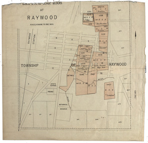
Plan, Raywood Gold Mining Lease Blocks, c1986
... Victoria. Raywood Raywood Botanical Gardens pound Raywood state School Buxton new buxton new perserverance pioneer new nil south pioneer and May reef london Gold mining lease blocks at Raywood. Thought to be from The Gold-Fields of Victoria Reports of The Mining Registrars for the Quarter Ended 30th June 1886 Raywood Gold Mining Lease Blocks Plan ...Raywood is in the State of Victoria.Gold mining lease blocks at Raywood. Thought to be from The Gold-Fields of Victoria Reports of The Mining Registrars for the Quarter Ended 30th June 1886raywood, raywood botanical gardens, pound, raywood state school, buxton, new buxton, new perserverance, pioneer, new nil, south pioneer and may reef, london -
 Bendigo Historical Society Inc.
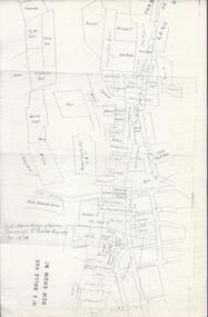
Map - MINING PLAN ,VICTORIA HILL AREA, No date visible
... plan...Mining... Gold Mines... Victoria Hill... Lines of Reef...History House 11 Mackenzie Street Bendigo goldfields MAP Bendigo mining plan Mining Gold Mines Victoria Hill Lines of Reef Map: Large scale plan of an area of the Goldfield, Northward from Barnard Street, covering the Victoria Hill area. ...Map: Large scale plan of an area of the Goldfield, Northward from Barnard Street, covering the Victoria Hill area. Black printing on polycarbonate film. Transparent.map, bendigo, mining plan, mining, gold mines, victoria hill, lines of reef -
 Bendigo Historical Society Inc.
Plan - North Hustlers Gold Mine
... reef in Bendigo (formerly Sandhurst), Victoria. Active during the Victorian gold rush, the mine operated at significant depths, with historical records indicating activity around 800-1100 feet in the 1880s. It was located on the Hustlers line of reef gold mining gold Bendigo North Hustlers New Hustlers Hustlers Hill North Hustlers Gold Mine Plan forms part of the Margaret Roberts Collection. ...The North Hustlers Gold Mine (also known as New Hustlers) was a prominent 19th and early 20th-century gold-mining operation located on the rich Hustler's line of reef in Bendigo (formerly Sandhurst), Victoria. Active during the Victorian gold rush, the mine operated at significant depths, with historical records indicating activity around 800-1100 feet in the 1880s. It was located on the Hustlers line of reefNorth Hustlers Gold Mine Plan forms part of the Margaret Roberts Collection.gold mining, gold, bendigo, north hustlers, new hustlers, hustlers hill -
Bendigo Historical Society Inc.
Plan - Oswald Gold Mine
... Victoria, Australia. It was situated on Parkins Reef Road, running south from Mount Tarrangower. This highly successful mine, managed by Robert Dent Oswald, was a major quartz-mining site in the late 19th century. gold mining gold Bendigo North Hustlers New Hustlers Hustlers Hill Oswald Gold Mine Plan forms part of the Margaret Roberts Collection. ...The Oswald Gold Mine, often referred to as the North British Mine, was located approximately 2 kilometres south-east of the town of Maldon in central Victoria, Australia. It was situated on Parkins Reef Road, running south from Mount Tarrangower. This highly successful mine, managed by Robert Dent Oswald, was a major quartz-mining site in the late 19th century. Oswald Gold Mine Plan forms part of the Margaret Roberts Collection.gold mining, gold, bendigo, north hustlers, new hustlers, hustlers hill -
Bendigo Historical Society Inc.
Plan - Oswald North British Gold Mine
... Victoria, Australia. It was situated on Parkins Reef Road, running south from Mount Tarrangower. This highly successful mine, managed by Robert Dent Oswald, was a major quartz-mining site in the late 19th century. gold mining gold Bendigo Oswald Gold Mine North British Gold Mine Maldon Oswald North British Gold Mine Plan forms part of the Margaret Roberts Collection. ...The Oswald Gold Mine, often referred to as the North British Mine, was located approximately 2 kilometres south-east of the town of Maldon in central Victoria, Australia. It was situated on Parkins Reef Road, running south from Mount Tarrangower. This highly successful mine, managed by Robert Dent Oswald, was a major quartz-mining site in the late 19th century. Oswald North British Gold Mine Plan forms part of the Margaret Roberts Collection.gold mining, gold, bendigo, oswald gold mine, north british gold mine, maldon -
 Bendigo Historical Society Inc.
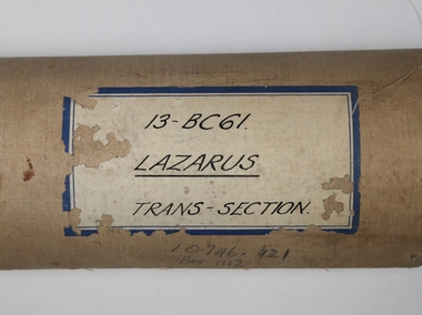
Plan - Lazarus Gold Mine, W.H. Cundy, Mining Engineer, Unknown
... See No. 3547, Bendigo Historical Society on Victoria Collections: https://victoriancollections.net.au/items/6684d58216337b271b28f843 ' Lazarus Mine', history of mine site by Albert Richardson. gold mining gold Margaret Roberts Collection Lazarus gold mine Thorpe's reef Shenandoah reef Old Chum Reef New Chum Reef Barnett Lazarus New Chum Hill New Chum Reef line W.H. Cundy Transverse section of Lazarus mine, showing the 'old shaft' and second shaft with poppet head. Old Chum, New Chum and Thorpe's Reef, Consolidated Reef and Shenandoah Reef are marked on plan ...The Lazarus New Chum Mining Company was first gazetted in 1871, with Barnett Lazarus the main shareholder with 20,000 shares. (Government Gazette 40 Page 956). The place of operation was 'New Chum'. See No. 3547, Bendigo Historical Society on Victoria Collections: https://victoriancollections.net.au/items/6684d58216337b271b28f843 ' Lazarus Mine', history of mine site by Albert Richardson. Transverse section of Lazarus mine, showing the 'old shaft' and second shaft with poppet head. Old Chum, New Chum and Thorpe's Reef, Consolidated Reef and Shenandoah Reef are marked on plan. Plan shows 40 levels in the Lazarusmine with a shaft depth of 3747 feet. On top right hand of plan: ' Transverse section of Lazarus mine, drawn by W.H. Cundy'. Mine plan is part of the Margaret Roberts Collection. gold mining, gold, margaret roberts collection, lazarus gold mine, thorpe's reef, shenandoah reef, old chum reef, new chum reef, barnett lazarus, new chum hill, new chum reef line, w.h. cundy -
 Bendigo Historical Society Inc.
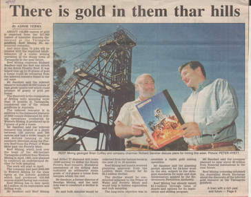
Newspaper - Kangaroo Flat Gold Mine Collection: Victoria Hill
... Reef Mining geologist Brian Cuffley and Company Chairman, Richard Sandner, are pictured discussing plans proposed for the Tarnagulla goldfield, where it is expected that '150,000 ounces of gold will be extracted from 527,000 tonnes of mineable deposits discovered at the Tarnagulla goldfield'. Colour photo shows Brian Cuffley and Richard Sandner, looking at a book titled 'Reef Mining, Tarnagulla Gold Field'. They are standing near a head frame. Newspaper Kangaroo Flat Gold Mine Collection: Victoria ...Bendigo Advertiser article, 4th March,1995, titled 'There is gold in them thar hills'. Reef Mining geologist Brian Cuffley and Company Chairman, Richard Sandner, are pictured discussing plans proposed for the Tarnagulla goldfield, where it is expected that '150,000 ounces of gold will be extracted from 527,000 tonnes of mineable deposits discovered at the Tarnagulla goldfield'. Colour photo shows Brian Cuffley and Richard Sandner, looking at a book titled 'Reef Mining, Tarnagulla Gold Field'. They are standing near a head frame.gold mining, bendigo, western mining, tarnagulla, reef mining company, richard sandner, brian cuffley -
 Bendigo Historical Society Inc.
Map - BENDIGO GOLDFIELDS MAP
... Map of the Bendigo Goldfield, showing reef lines, mines and significant geographical features such as Monument Hill, Quartz Hill and Diamond Hill. On the back of map 'Department of Mines, Victoria. Plan...History House 11 Mackenzie Street Bendigo goldfields BENDIGO Mining bendigo goldfields Map of the Bendigo Goldfield, showing reef lines, mines and significant geographical features such as Monument Hill, Quartz Hill and Diamond Hill. On the back of map 'Department of Mines, Victoria. Plan ...Map of the Bendigo Goldfield, showing reef lines, mines and significant geographical features such as Monument Hill, Quartz Hill and Diamond Hill. On the back of map 'Department of Mines, Victoria. Plan of Bendigo Goldfield.bendigo, mining, bendigo goldfields -
Bendigo Historical Society Inc.
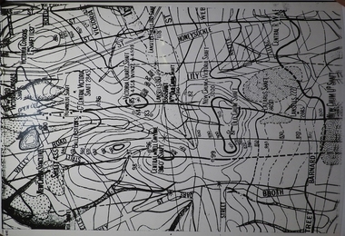
Map - SECTIONS ACROSS BENDIGO GOLDFIELD
... reef line maps Geological Survey of Victoria Map in three sections showing sections across Bendigo Gold Field, showing anticlines, synclines, faults, stratigraphical zones and mines along the reef lines. Key shows rock types Castlemaine, Bendigo B1, B2, B3 and B4, and Lancefieldian. First part of map shows sections A-A, B-B and C-C. Reef lines drawn with mines listed: Fault line shown are the Carshalton, Stafford, New Chum, Virginia and Clarence. A datum line shows 600 ft above sea level. On bottom of plan ...Map in three sections showing sections across Bendigo Gold Field, showing anticlines, synclines, faults, stratigraphical zones and mines along the reef lines. Key shows rock types Castlemaine, Bendigo B1, B2, B3 and B4, and Lancefieldian. First part of map shows sections A-A, B-B and C-C. Reef lines drawn with mines listed: Fault line shown are the Carshalton, Stafford, New Chum, Virginia and Clarence. A datum line shows 600 ft above sea level. On bottom of plan: ' Prepared in the Geological Survey Office, Bendigo, under the direction of H. Herman, late Director of Geological Survey, from surveys by H.S. Whitelaw, Field Geologist, assisted by E.S. Usher, A.J.J. Moore and R.A. Keble.' Second section of map shows sections D-D, and E-E. Fault lines listed are the Tambour Major fault, Carshalton fault, Stafford fault, Nell Gwynne fault, New Chum fault, Deborah fault. Third section shows sections F-F and G-G. Fault lines listed are the Bird Reef fault, Kangaroo Gully fault, Langdon fault, Carshalton fault, Nell Gwynne fault, Spring Gully fault, Hustlers fault, Gravel Hill fault, Ordes fault, Thanet fault. This map forms part of the Geological Survey of Victoria, Structure of Bendigo Goldfield report, No. 47, 1923. H.Herman, late Director of Geological Survey.Geological Survey of Victoriabendigo, gold mining, reef line maps -
 Bendigo Historical Society Inc.
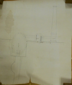
Document - MARKS COLLECTION: PLAN OF CHIMNEY STACK
... Plan could be associated with a mine on New Chum Reef Line, Victoria Hill....Plan could be associated with a mine on New Chum Reef Line, Victoria Hill. ...Unlabeled plan, drawing shows side view of chimney stack, '5 feet' written on base of chimney. Plan could be associated with a mine on New Chum Reef Line, Victoria Hill.bendigo, mining, chimney side section, chimney stack -
 Bendigo Historical Society Inc.
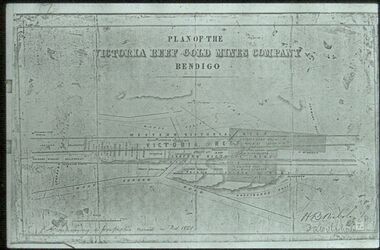
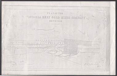
Document - VICTORIA REEF GOLD MINES COMPANY BENDIGO PLAN
... VICTORIA REEF GOLD MINES COMPANY BENDIGO PLAN...PLAN...Bendigo...victoria reef gold mines company...Photocopy of a Plan of the Victoria Reef Gold Mines Company, Bendigo. ...Victoria Reef Gold Mines Company Lease No. 2 and Lease No. 3. The gullies are named Happy Valley, Long, Derwent, Providence and Ironbark Gullies. The reefs are: Western Victoria, Victoria, Eastern Victoria and Prince Albert Reef. Between the Eastern Victoria Reef and the Prince Albert Reef is the White Lead. Mount Korong Road is at the bottom of the plan ...Photocopy of a Plan of the Victoria Reef Gold Mines Company, Bendigo. Shaded area is the Victoria Reef Gold Mines Company Lease No. 2 and Lease No. 3. The gullies are named Happy Valley, Long, Derwent, Providence and Ironbark Gullies. The reefs are: Western Victoria, Victoria, Eastern Victoria and Prince Albert Reef. Between the Eastern Victoria Reef and the Prince Albert Reef is the White Lead. Mount Korong Road is at the bottom of the plan. Other Leaseholders are: Burrows, Wybrant, Ballerstedt, Jackson,Roberts & Co, Ashley, Grant, ?rpe, ?eau, Woodward, Coath, Taylor, Cranshaw, Roberts, Gould & Co, Midway, Witscheibe, Endeavour Co, Albert Co, Ballerstedt & Son, Late Iron Bark Quartz Mining Co, McDougall, Specimen Hill Co, Hygrect?, Wheadon, Evans and Bannerman. Signed by H. B. Nicholas. Location of Ballerstedt, Luffsman, Midway Co, Witscheibe and Rae & Co engine locations. Hills are shown as hatch shading. Written at the bottom left ocrner is: Accompanying prospectus issued in Nov. 1859. Signed H.B. Nicholas.plan, bendigo, victoria reef gold mines company, victoria reef gold mines company bendigo - plan, h b nicholas, burrows, wybrant, ballerstedt, jackson, roberts & co, ashley, grant, ?rpe, ?eau, woodward, coath, taylor, cra-shaw, roberts, gou-d & co, midway, witscheibe, endeavour co, albert co, ballerstedt & son, late iron bark quartz mining co, mcdougall, specimen hill co, hyo?, wheadon, evans, bannerman. -
 Bendigo Historical Society Inc.
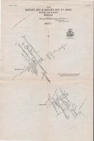
Map - STRUGNELL COLLECTION: HUSTLER'S LINE OF REEFS, September 1913
... Reef No.1 Mines, Plan view . Plate No. XV (15).Sheet 1 Bulletin No. 33. Included is the emblem of the Geological Survey of Victoria. ...Reef No.1 Mines, Plan view . Plate No. XV (15).Sheet 1 Bulletin No. 33. Included is the emblem of the Geological Survey of Victoria. ...Map, Hustler's Line of Reefs, Hustler's Reef & Hustler's Reef No.1 Mines, Plan view . Plate No. XV (15).Sheet 1 Bulletin No. 33. Included is the emblem of the Geological Survey of Victoria. Signed by H.A.Whitelaw Underground Survey Office, Bendigo, Septembe ,1913.Underground Survey Office, Bendigo.map, bendigo, hustler's reef & hustler's reef 1 -
 Bendigo Historical Society Inc.
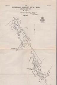
Map - STRUGNELL COLLECTION: HUSTLER'S LINE OF REEFS, September 1913
... Reef No.1 Mines Plan.Plate No. XV1.(16) Sheet 2 .Bulletin No 33 Signed H.A.Whitelaw.Underground Survey Office, Bendigo, September,1913. Included is the emblem of the Geological Survey of Victoria. Drawing shows a plan...Reef No.1 Mines Plan.Plate No. XV1.(16) Sheet 2 .Bulletin No 33 Signed H.A.Whitelaw.Underground Survey Office, Bendigo, September,1913. Included is the emblem of the Geological Survey of Victoria. Drawing shows a plan ...Map, Hustler's Line of Reefs, Hustler's Reef & Hustler's Reef No.1 Mines Plan.Plate No. XV1.(16) Sheet 2 .Bulletin No 33 Signed H.A.Whitelaw.Underground Survey Office, Bendigo, September,1913. Included is the emblem of the Geological Survey of Victoria. Drawing shows a plan view of reefs and shaft locations .Underground Survey Office, Bendigomap, bendigo, hustler's reef & hustler's reef 1 -
 Bendigo Historical Society Inc.
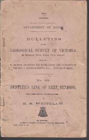
Book - STRUGNELL COLLECTION: DEPARTMENT OF MINES: 1914 GEOLOGICAL SURVEY OF VICTORIA. HUSTLERS LINE OF REEF, 1914
... Book, Department of Mines, Bulletins of the Geological Survey of Victoria, No.33, Hustler's Line Of Reef, Bendigo, with plans,sections, and photographs, by H.S.Whitelaw. 13833, Price 2s.6d....reef Albert J. Mullett, Government Printer, Melbourne. Book, Department of Mines, Bulletins of the Geological Survey of Victoria, No.33, Hustler's Line Of Reef, Bendigo, with plans,sections, and photographs, by H.S.Whitelaw. 13833, Price 2s.6d. ...Book, Department of Mines, Bulletins of the Geological Survey of Victoria, No.33, Hustler's Line Of Reef, Bendigo, with plans,sections, and photographs, by H.S.Whitelaw. 13833, Price 2s.6d.`Back cover shows J.A. and J.A Strugnell , 12 Mulbar St Swan Hill 3585 .Albert J. Mullett, Government Printer, Melbourne.book, bendigo, hustler's line of reef -
 Bendigo Historical Society Inc.
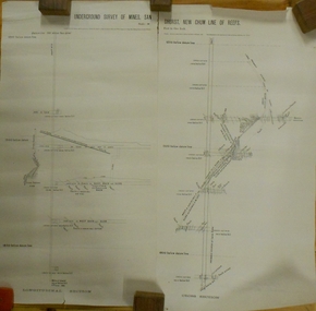
Plan - MARKS COLLECTION: UNDERGROUND SURVEY OF MINES SANDHURST NEW CHUM LINE OF REEF
... Plan, divided into two sheets, on top of sheet Underground survey of mines Sandhurst, New Chum Line of Reef. Surveyed by Caleb Thomas under the direction of Charles W. Langtree, Acting Secretary for Mines and Water Supply and Acting Chief Mining Surveyor for the Colony of Victoria. ...reef Plan, divided into two sheets, on top of sheet Underground survey of mines Sandhurst, New Chum Line of Reef. Surveyed by Caleb Thomas under the direction of Charles W. Langtree, Acting Secretary for Mines and Water Supply and Acting Chief Mining Surveyor for the Colony of Victoria. ...Plan, divided into two sheets, on top of sheet Underground survey of mines Sandhurst, New Chum Line of Reef. Surveyed by Caleb Thomas under the direction of Charles W. Langtree, Acting Secretary for Mines and Water Supply and Acting Chief Mining Surveyor for the Colony of Victoria. Drawn by Arthur Everett, Mining Department, Melbourne, 1884.bendigo, mining, new chum line of reef -
 Bendigo Historical Society Inc.
Document - MARKS COLLECTION: ABE LINCOLN CO LEASE
... Plan Showing Position of the Abe Lincoln Co. Lease, New Chum, Sandhurst' under name 'by H.B. Nicholas, Mining Surveyor' Sheepshead Reef, Easter reef, Alfred Reef, Allingham Reef,Adventure Reef, Belle Vue Reef, New Chum Reef, Black Lead, Victoria Reef lines shown on map with mine leases marked. ...Plan Showing Position of the Abe Lincoln Co. Lease, New Chum, Sandhurst' under name 'by H.B. Nicholas, Mining Surveyor' Sheepshead Reef, Easter reef, Alfred Reef, Allingham Reef,Adventure Reef, Belle Vue Reef, New Chum Reef, Black Lead, Victoria Reef lines shown on map with mine leases marked. ...Two copies of plan for Abe Lincoln Co. Lease, New Chum, Sandhurst. One original, one copy. On top of plan 'Plan Showing Position of the Abe Lincoln Co. Lease, New Chum, Sandhurst' under name 'by H.B. Nicholas, Mining Surveyor' Sheepshead Reef, Easter reef, Alfred Reef, Allingham Reef,Adventure Reef, Belle Vue Reef, New Chum Reef, Black Lead, Victoria Reef lines shown on map with mine leases marked. On bottom of map 'Monument Hill Reef' line marked.bendigo, mining, abe lincoln lease -
 Bendigo Historical Society Inc.
Document - PLAN SHOWING THE VARIOUS CLAIMS ON THE NEW CHUM VICTORIA , ST MUNGO & DEVONSHIRE REEFS BENDIGO
... Map of mines - calico scroll showing locations of various claims .printed in black ink on off-white Calico with turned wooden ends on scroll -missing one wooden end , some stains and creasing / Plan showing the various Claims on the New Chum Victoria , St Mungo & Devonshire reefs Bendigo...History House 11 Mackenzie Street Bendigo goldfields ORGANIZATION Mining industrial W Holmes printer & lithographer Sandhurst/New Cum Victoria St Mungo & Devonshire reefs Bendigo W Holmes , printer & lithographer , Sandhurst Map of mines - calico scroll showing locations of various claims .printed in black ink on off-white Calico with turned wooden ends on scroll -missing one wooden end , some stains and creasing / Plan showing the various Claims on the New Chum Victoria , St Mungo & Devonshire reefs Bendigo Document PLAN SHOWING THE VARIOUS CLAIMS ON THE NEW CHUM VICTORIA , ST MUNGO & DEVONSHIRE REEFS BENDIGO ...Map of mines - calico scroll showing locations of various claims .printed in black ink on off-white Calico with turned wooden ends on scroll -missing one wooden end , some stains and creasing / Plan showing the various Claims on the New Chum Victoria , St Mungo & Devonshire reefs BendigoW Holmes , printer & lithographer , Sandhurstorganization, mining, industrial, w holmes , printer & lithographer , sandhurst/new cum , victoria st mungo & devonshire reefs bendigo -
 Bendigo Historical Society Inc.
Document - LANSELL'S BIG 180 MINE - CONDENSED HISTORICAL RECORD OF LANSELL'S BIG 180 MINE
... History House 11 Mackenzie Street Bendigo goldfields DOCUMENT Gold lansell's big 180 mine Lansell's Big 180 Mine Condensed Historical Record of Lansell's Big 180 Mine Wittscheibe Ballerstadt Ernst Mueller Theodore Ballerstadt George Lansell North Old Chum Victoria Quartz Mines Dept Special Edition 'Australian Mining Standard' 1/6/1899 Mines Dept Booklet 'Bendigo Goldfield' 1936 Quarterly Reports Lansell's 180 Mine 'Transverse Sections Annals of Bendigo Mining Sections A Richardson's observations from old photographs and measurements of mining plans Measurements taked from Caleb Thomas' Report Mines Dept 1875 'Report on observation of Underground Temperature at Bendigo' James Stirling Government Geologist 1899 A Richardson Two handwritten and three typed copies of a Condensed Historical Record of Lansell's Big 180 Mine on the New Chum Line of Reef. ...Two handwritten and three typed copies of a Condensed Historical Record of Lansell's Big 180 Mine on the New Chum Line of Reef. Notes include location, shaft, first worked, size of lease, plant, engine house, boiler rooms, mullock heap, early history, Prominent, best gold, underground connections, pressurised hot water, diamond drill bores and a table with depths and the increase in temperature with the depth (in Fahr). Albert Richardson Collection. document, gold, lansell's big 180 mine, lansell's big 180 mine, condensed historical record of lansell's big 180 mine, wittscheibe, ballerstadt, ernst mueller, theodore ballerstadt, george lansell, north old chum, victoria quartz, mines dept special edition 'australian mining standard' 1/6/1899, mines dept booklet 'bendigo goldfield' 1936, quarterly reports, lansell's 180 mine 'transverse sections, annals of bendigo mining sections, a richardson's observations from old photographs and measurements of mining plans, measurements taked from caleb thomas' report mines dept 1875, 'report on observation of underground temperature at bendigo' james stirling government geologist 1899, a richardson -
 Bendigo Historical Society Inc.
Map - BELLE VUE NO 2 - PLAN OF LEASES
... plan...Belle Vue No 2... No 2 Belle Vue New Chum & C... J N Macartney Bendigo Goldfields Registry 1872... Moore ?... Ellesmere Co... Bonati & Co... Dennis... Abe Lincoln Co... Lansell & Hunt... Black & White Lead Co... Koch & Hildebrand... Ballerstedt... Lazarus Co No 1... Lazarus Co... Watson... Lazarus Freehold... Lazarus Co No 2... Lazarus Tribute... South Extended Burra... Endeavor Co... Old Chum Co... Burrows and Sterry... New Chum & Victoria Trib... Jackson... North Old Wybrants Chum Co... Myra Co... McLenn... Geary & Co... Western Victoria Hill G. M. Co... Victoria Reef...Plan of Mining Leases from Rowan Street to Long Gully. Reference J. N. Macartney 2nd Edition Bendigo Goldfields Registry for 1872. Names of Leases are: Moore ?, Ellesmere Co, Bonati & Co, Dennis, Abe Lincoln Co, Lansell & Hunt, Black & White Lead Co, Koch & Hildebrand, Ballerstedt, Lazarus Co No 1, Lazarus Co, Watson, Lazarus Freehold, Lazarus Co No 2, Lazarus Tribute, South Extended Burra, Endeavor Co, Old Chum Co, Burrows and Sterry, New Chum & Victoria Trib, Jackson, North Old Wybrants Chum Co, Myra Co, McLenn, Geary & Co, Western Victoria Hill G. M. Co, Victoria Reef...Rae Wells Midway Extended Co Handy Andy Moonta Co Humboldt Co Adventure Co Try Me Well Sterry & Co Midway Tudor Friedman's Reef Rising Sun Try Me Luck Pomponia Confidence Co Alfred Co Advance Co Prince Alfred Co Canterbury Co Platus Co S. Platus Co Golden Fleece United Alfred Co Iron Duke Co Victoria Gold Mines Co Hercules Co Iron Bark Plan of Mining Leases from Rowan Street to Long Gully. ...BHS CollectionPlan of Mining Leases from Rowan Street to Long Gully. Reference J. N. Macartney 2nd Edition Bendigo Goldfields Registry for 1872. Names of Leases are: Moore ?, Ellesmere Co, Bonati & Co, Dennis, Abe Lincoln Co, Lansell & Hunt, Black & White Lead Co, Koch & Hildebrand, Ballerstedt, Lazarus Co No 1, Lazarus Co, Watson, Lazarus Freehold, Lazarus Co No 2, Lazarus Tribute, South Extended Burra, Endeavor Co, Old Chum Co, Burrows and Sterry, New Chum & Victoria Trib, Jackson, North Old Wybrants Chum Co, Myra Co, McLenn, Geary & Co, Western Victoria Hill G. M. Co, Victoria Reef G.M.Co, South Adventure Co, South Try Me Well, W. Rae, Wells Midway, Extended Co, Handy Andy, Moonta Co, Humboldt Co, Adventure Co, Try Me Well, Sterry & Co, Midway, Tudor, Friedman's Reef, Rising Sun, Try Me Luck, Pomponia, Confidence Co, Alfred Co, Advance Co, Prince Alfred Co, Canterbury Co, Platus Co, S. Platus Co, Golden Fleece United, Alfred Co, Iron Duke Co, Victoria Gold Mines Co, Hercules Co and Iron Bark. Notes prepared by Albert Richardson.map, bendigo, mining plan, belle vue no 2, no 2 belle vue new chum & c, j n macartney bendigo goldfields registry 1872, moore ?, ellesmere co, bonati & co, dennis, abe lincoln co, lansell & hunt, black & white lead co, koch & hildebrand, ballerstedt, lazarus co no 1, lazarus co, watson, lazarus freehold, lazarus co no 2, lazarus tribute, south extended burra, endeavor co, old chum co, burrows and sterry, new chum & victoria trib, jackson, north old wybrants chum co, myra co, mclenn, geary & co, western victoria hill g. m. co, victoria reef g.m.co, south adventure co, south try me well, w. rae, wells midway, extended co, handy andy, moonta co, humboldt co, adventure co, try me well, sterry & co, midway, tudor, friedman's reef, rising sun, try me luck, pomponia, confidence co, alfred co, advance co, prince alfred co, canterbury co, platus co, s. platus co, golden fleece united, alfred co, iron duke co, victoria gold mines co, hercules co, iron bark -
 Bendigo Historical Society Inc.
Book - MINING REPORTS - THE CONFIDENCE GROUP OF MINES BULLETIN NO 41
... Victoria issued by W Dickson, Secretary for Mines, Under the Authority of the Hon. S Barnes M L A Minister of Mines. No 41 The Confidence Group of Mines, Bendigo with Plans and Sections by H S Whitelaw, Field Geologist, dated 1918. Mines mentioned are: Confidence Extended Mine, Confidence Tribute Company and the Central Windmill Hill Mine. Mentioned in the report are crushings and gold yield, details of levels, names of leases along the reef...Victoria issued by W Dickson, Secretary for Mines, Under the Authority of the Hon. S Barnes M L A Minister of Mines. No 41 The Confidence Group of Mines, Bendigo with Plans and Sections by H S Whitelaw, Field Geologist, dated 1918. Mines mentioned are: Confidence Extended Mine, Confidence Tribute Company and the Central Windmill Hill Mine. Mentioned in the report are crushings and gold yield, details of levels, names of leases along the reef ...Light brown covered booklet 'Bulletins of the Geological Survey of Victoria issued by W Dickson, Secretary for Mines, Under the Authority of the Hon. S Barnes M L A Minister of Mines. No 41 The Confidence Group of Mines, Bendigo with Plans and Sections by H S Whitelaw, Field Geologist, dated 1918. Mines mentioned are: Confidence Extended Mine, Confidence Tribute Company and the Central Windmill Hill Mine. Mentioned in the report are crushings and gold yield, details of levels, names of leases along the reef. Extracts from Mine Manager's Half-yearly Reports, 1878-1915 of tons crushed and gold yield. Plans and sections of the Confidence Extended Mine on the Garden Gully Line of Reefs are: Plate I General Plan of All Levels, Plans of Levels Plate No II, Plans of Levels Plate No III, Transverse Section Plate No IV, Longitudinal Section Plate No V, and Central Windmill Hill Mine Transverse Section Plate No VI. Plates signed by H S Whitelaw 17 & 18/6/16 and 20/7/16. Booklet if part of the Albert Richardson Collection. book, bendigo, mining reports, mining reports, the confidence group of mines bulletin no 41, confidence extended mine, confidence tribute company, central windmill hill mine, department of mines, bulletins of the geological survey of victoria, w dickson, the hon s barnes, h s whitelaw, h j green, mr robert eddy, mr w h cundy, j foster, c j thompson -
 Bendigo Historical Society Inc.
Document - NEW CHUM & VICTORIA LINES OF REEF - NEW CHUM CONSOLIDATED COMPANY, S'HURST
... History House 11 Mackenzie Street Bendigo goldfields DOCUMENT Gold new chum & victoria lines of reef New Chum & Victoria Lines of Reef New Chum Consolidated Company S'hurst Shenandoah Garibaldi Mr John Delbridge Pearl Company Handwritten notes from Se? Mines Report Pages 46 & 47 on the Machinery at New Chum Consolidated Company, Sandhurst. Notes include boilers, Compressors, Battery and mentions plans ...Handwritten notes from Se? Mines Report Pages 46 & 47 on the Machinery at New Chum Consolidated Company, Sandhurst. Notes include boilers, Compressors, Battery and mentions plans. There are also descriptions of the machinery. A typed copy is also included.document, gold, new chum & victoria lines of reef, new chum & victoria lines of reef, new chum consolidated company s'hurst, shenandoah, garibaldi, mr john delbridge, pearl company -
 Bendigo Historical Society Inc.
Document - NEW CHUM LINE OF REEF - REFERENCE TO CALEB THOMAS PLANS
... New Franklin Murchison Catherine Reef United Catherine Reef (South) Acadia Catherine William's United York & Durham Belmont & Saxby Ellenborough Sadowa (old) St Mungo Lady Barkly Princess Alice (Sth St Mungo) Unicorn Trib Pheonix Hopewell United Devonshire (Princess Alex) West United Devonshire East United Devonshire Duchess of Edinburgh South Devonshire Duchess Tribute New St Mungo New St Mungo New Vict Catherine Gt Extd Vict Herc New Chum (Late Pearl) Pearl South North Herc & Energetic Herc & Energetic Ironbark Vict Consols South New Chum Lansell's 616 South Belle Vue Eureka Extd New Chum Rly South Old Chum New Chum Consolidated Ellesmere (South Shaft) Garibaldi Cravens Young Chum Ellesmere Nth Shaft New Chum United New Chum Vic Old Chum Lazarus Cent New Chum Lansell's 222 North Old Chum Lansell's Big 180 Advents Advance Gt Cent Vict Hamboldt Ballerstedt Victoria Quartz Herc & Energetic Herc (Old) Shenandoah Victoria Reef Gold Victoria Consols Five pages (typed copy of Albert Richardson original) of reference numbers used on Caleb Thomas plans. ...Five pages (typed copy of Albert Richardson original) of reference numbers used on Caleb Thomas plans. The mine's name, size of shaft and on other pages, the height of the sill. document, gold, mines, new chum line of reef, reference to caleb thomas plans, catherine reef extd., new franklin, murchison, catherine reef united, catherine reef (south), acadia catherine, william's united, york & durham, belmont & saxby, ellenborough, sadowa, (old) st mungo, lady barkly, princess alice (sth st mungo), unicorn trib, pheonix, hopewell, united devonshire (princess alex), west united devonshire, east united devonshire, duchess of edinburgh, south devonshire, duchess tribute, new st mungo, new st mungo, new vict catherine, gt extd vict, herc new chum (late pearl), pearl south, north herc & energetic, herc & energetic, ironbark, vict consols, south new chum, lansell's 616, south belle vue, eureka extd, new chum rly, south old chum, new chum consolidated, ellesmere (south shaft), garibaldi, cravens, young chum, ellesmere nth shaft, new chum united, new chum vic, old chum, lazarus, cent new chum, lansell's 222, north old chum, lansell's big 180, advents advance, gt cent vict, hamboldt, ballerstedt, victoria quartz, herc & energetic, herc (old), shenandoah, victoria reef gold, victoria consols -
 Bendigo Historical Society Inc.
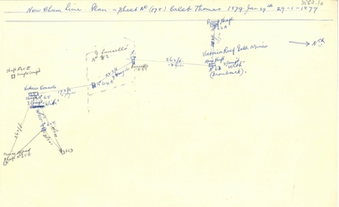
Document - NEW CHUM LINE OF REEF - PART OF A PLAN OF MINES ALONG THE NEW CHUM LINE OF REEF
... History House 11 Mackenzie Street Bendigo goldfields DOCUMENT Gold New Chum Line Of Reef Part of a plan of mines along the New Chum Line Of Reef Caleb Thomas Hercules Mine Energetic Mine Energetic Coy Sketch of mines along the New Chum Line of Reef Sheet No 1 (811) Caleb Thomas Jun 28, 1879. Mines mentioned are the Hercules and the Energetic. The others are shaft numbers. Measurements between each in feet and yards. Probable course of cap of Victoria ...Sketch of mines along the New Chum Line of Reef Sheet No 1 (811) Caleb Thomas Jun 28, 1879. Mines mentioned are the Hercules and the Energetic. The others are shaft numbers. Measurements between each in feet and yards. Probable course of cap of Victoria Reef drawn in.document, gold, new chum line of reef, part of a plan of mines along the new chum line of reef, caleb thomas, hercules mine, energetic mine, energetic coy -
 Bendigo Historical Society Inc.
Document - NEW CHUM LINE OF REEF - PLAN OF MINES ALONG PART OF THE NEW CHUM LINE OF REEF
... Reef... Plan of Mines along part of the New Chum Line Of Reef... Caleb Thomas... Prince Alfred Mine... Victoria...History House 11 Mackenzie Street Bendigo goldfields DOCUMENT Gold New Chum Line Of Reef Plan of Mines along part of the New Chum Line Of Reef Caleb Thomas Prince Alfred Mine Victoria Consols G Lansell's No 83 Ironbark Victoria Reef Gold Mines Sketch of some mines along the New Chum Line of Reef. ...Sketch of some mines along the New Chum Line of Reef. Sheet No (178) Caleb Thomas 1879 Jan 29th. Mines mentioned are: Prince Alfred, Victoria Consols, G Lansell's No 83. Some mines are only a number. Victoria Reef Gold Mines are mentioned. Distances in feet or yards between them.document, gold, new chum line of reef, plan of mines along part of the new chum line of reef, caleb thomas, prince alfred mine, victoria consols, g lansell's no 83, ironbark, victoria reef gold mines -
 Bendigo Historical Society Inc.
Document - NEW CHUM LINE OF REEF - REFERENCE FOR CALEB THOMAS PLANS
... History House 11 Mackenzie Street Bendigo goldfields DOCUMENT Gold New Chum Line of Reef Reference for Caleb Thomas Plans New Chum Bellevue & Railway Reserve Bellevue & New Chum Shenandoah Shamrock Old Chum Little Chum New Chum Trib Young Chum Cravens Garibaldi No 1 Ellesmere Coy New Chum Consolidated Ellesmere New Chum United Lansell's 222 (denis) Lansell's 222 (New Shaft) Koch & Hildebrandt (Lansell's 222) Lazarus Co Sheer Legs Old Chum New Chum & Victoria North Old Chum Lansell's 180 Victoria Quartz Gt Cent Vic Victoria Consols Victoria Reef Co (Ironbark) Hercules Energetic Ladder Shaft Energetic Shaft Two handwritten pages of reference numbers for Caleb Thomas plans. ...Two handwritten pages of reference numbers for Caleb Thomas plans. The numbers refer to mines on the New Chum Line of Reef.document, gold, new chum line of reef, reference for caleb thomas plans, new chum bellevue & railway reserve, bellevue & new chum, shenandoah, shamrock, old chum, little chum, new chum trib, young chum, cravens, garibaldi, no 1 ellesmere coy, new chum consolidated, ellesmere, new chum united, lansell's 222 (denis), lansell's 222 (new shaft), koch & hildebrandt (lansell's 222), lazarus co, sheer legs, old chum, new chum & victoria, north old chum, lansell's 180, victoria quartz, gt cent vic, victoria consols, victoria reef co (ironbark), hercules, energetic ladder shaft, energetic shaft