Showing 361 items matching "victorian landscapes"
-
 University of Melbourne, Burnley Campus Archives
Negative - Colour negatives, Plant Materials, Unknown
... ...victorian landscapes...University of Melbourne, Burnley Campus Archives 500 Yarra Boulevard Richmond melbourne plant materials acacias urban landscapes evergreen shrubs winter flowering shrubs evergreen trees weeds plant protection trees victorian landscapes conifers degree diploma plant id Labelled, "Acacias 1 & 2, Urban L'scapes, Evergreen Shrubs, Winter Flowering Shrubs, Evergreen Trees & Shrubs, Weeds-Plant Protection, S2-YearI, Big Trees, Victorian L'scape, Large Conifers." 11 rolls colour negatives Plant Materials Negative Colour negatives ...11 rolls colour negatives Labelled, "Acacias 1 & 2, Urban L'scapes, Evergreen Shrubs, Winter Flowering Shrubs, Evergreen Trees & Shrubs, Weeds-Plant Protection, S2-YearI, Big Trees, Victorian L'scape, Large Conifers."plant materials, acacias, urban landscapes, evergreen shrubs, winter flowering shrubs, evergreen trees, weeds, plant protection, trees, victorian landscapes, conifers, degree, diploma, plant id -
Tatura Irrigation & Wartime Camps Museum
Artwork, other - Painting oil, Victorian Summer Landscape
... Victorian Summer Landscape...Tag attached - reads "Victorian Summer Landscape by Frau Rippert in Camp 3. ...Transported on Queen Elizabeth to Australia and interned at Camp 3 1941-1945. landscape Tag attached - reads "Victorian Summer Landscape by Frau Rippert in Camp 3. ...This artwork was painted by Charlotte Rippert who was interned in Camp 3 with her whole family. The painting was painted in camp. Charlotte Rippert was a German Lutheran Missionary in Egypt, arrested as a security risk in Cairo, 1941. Transported on Queen Elizabeth to Australia and interned at Camp 3 1941-1945.Rectangular wooden frame - oil painting on wooden board - scene depicting blue river, trees, shrubbery and unsealed road in the foreground and a yellow hill in the backgroundTag attached - reads "Victorian Summer Landscape by Frau Rippert in Camp 3. Donors: Glockemann Family."landscape -
 Bendigo Historical Society Inc.
Painting - NORMAN PENROSE COLLECTION: WOMEN'S FASHION, Autumn 1940
... Norman William Penrose (1903–1976) was an Australian painter and art teacher renowned for his depictions of regional Victorian landscapes and everyday scenes, particularly around Bendigo where he spent most of his life...Norman William Penrose (1903–1976) was an Australian painter and art teacher renowned for his depictions of regional Victorian landscapes and everyday scenes, particularly around Bendigo where he spent most of his life ARTWORK Norman Penrose Collection artwork women's fashion Artwork. ...Norman William Penrose (1903–1976) was an Australian painter and art teacher renowned for his depictions of regional Victorian landscapes and everyday scenes, particularly around Bendigo where he spent most of his lifeArtwork. Norman Penrose collection: various colour and black and white pictures of women's fashion taken from magazines, etc and pasted onto cardboard. Some blue and white illustrations of methods of drawing figures and clothing.artwork, norman penrose collection, artwork, women's fashion -
 Bendigo Historical Society Inc.
Painting - NORMAN PENROSE COLLECTION: ARTWORK
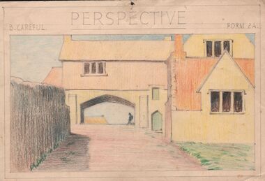
... Norman William Penrose (1903–1976) was an Australian painter and art teacher renowned for his depictions of regional Victorian landscapes and everyday scenes, particularly around Bendigo where he spent most of his life...Norman William Penrose (1903–1976) was an Australian painter and art teacher renowned for his depictions of regional Victorian landscapes and everyday scenes, particularly around Bendigo where he spent most of his life DRAWING Crayon Norman Penrose Collection artwork crayon drawings (C) N. ...Norman William Penrose (1903–1976) was an Australian painter and art teacher renowned for his depictions of regional Victorian landscapes and everyday scenes, particularly around Bendigo where he spent most of his lifeArtwork. Norman Penrose collection: (A) Crayon or pencil (coloured) drawing of a building and fence. A man is walking in an archway in the distance. The buildings are yellow and orange. The picture illustrates perspective. (B) Coloured crayon drawing of a one legged man carrying a parrot on his arm, walking along the cliff top beside the sea. A sailing ship is on the water. (C) Coloured crayon drawing of a green fire breathing dragon above the waves of the sea. The moon and stars are shining in a dark sky. The drawing has a blue paint wash. (D) Coloured crayon drawing of Robinson Crusoe. He is on the beach and has a large trunk open. He is looking in it. A number of coconuts and bowls are around the trunk. It is beside a palm tree. A ship with two masts is just off the shore.(C) N. Penrosedrawing, crayon, norman penrose collection, artwork, crayon drawings -
 Bendigo Historical Society Inc.
Painting - NORMAN PENROSE COLLECTION: BORDER PAINTINGS
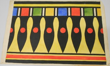
... Norman William Penrose (1903–1976) was an Australian painter and art teacher renowned for his depictions of regional Victorian landscapes and everyday scenes, particularly around Bendigo where he spent most of his life...Norman William Penrose (1903–1976) was an Australian painter and art teacher renowned for his depictions of regional Victorian landscapes and everyday scenes, particularly around Bendigo where he spent most of his life DRAWING Print Norman Penrose Collection artwork border paintings Artwork. ...Norman William Penrose (1903–1976) was an Australian painter and art teacher renowned for his depictions of regional Victorian landscapes and everyday scenes, particularly around Bendigo where he spent most of his lifeArtwork. Norman Penrose collection: 2 border paintings. One has black, red and yellow stripes at the top. A spear shaped design with a red spot in the centre. Yellow, green, red and blue squares separated by two black and a white strip and black and yellow stripes at the bottom. The second one has red, white and black stripes at the top. A black, red and green geometric design in the centre and a black stripe at the bottom. The background is unpainted.drawing, print, norman penrose collection, artwork, border paintings -
 Federation University Historical Collection
Book, Peter Lumley et al, Ballarat: Historic Landscapes, Trees & Gardens, 1983, 1983
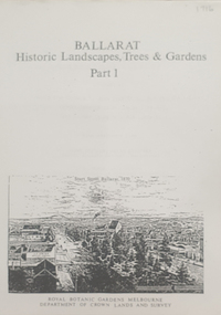
... 275 page landscape study of Ballarat including Trees in the Victorian Landscape; Plant sources early Ballarat nurseries, Botanical Gardens, Lake Wendouree, Fairy Gardens, Victoria Park, Ballaarat Old Cemetery, Eastern Oval, City Oval, Ballarat East Town Hall Gardens, Eureka Stockade, Observatory, Yarrowee, Black Hill, Sovereign Hill, Cheek Channels, Canadian Creek, Poverty Point Reserve, Goldmining Relics, Woah Hawp, Buninyong, street plantings, Russell, Victoria, Bridge Mall, Sturt Street Gardens, Avenue of Honour, Webster, Elms, ...Barker Library (top floor) Mount Helen goldfields Lisa Green and Lisa Morcom of Ballarat College of Advanced Educatiion contributed to this report. ballarat trees nursery r.u. nicholls francis moss ballarat botanical gardens Victoria Park Lake Wendouree Ballaarat Old Cemetery Eastern Oval Ballarat East Town Hall Gardens Ballarat School of Mines Botanical gardens Eureka Stckade Recreation Reserve Ballarat Observatory Yarrowee Creek Black Hill Reserve Sovereign Hill Ballarat Avenue of Honour Victoria Street plantings Bridge Mall Plantings george longley 275 page landscape study of Ballarat including Trees in the Victorian Landscape; Plant sources early Ballarat nurseries, Botanical Gardens, Lake Wendouree, Fairy Gardens, Victoria Park, Ballaarat Old Cemetery, Eastern Oval, City Oval, Ballarat East Town Hall Gardens, Eureka Stockade, Observatory, Yarrowee, Black Hill, Sovereign Hill, Cheek Channels, Canadian Creek, Poverty Point Reserve, Goldmining Relics, Woah Hawp, Buninyong, street plantings, Russell, Victoria, Bridge Mall, Sturt Street Gardens, Avenue of Honour, Webster, Elms, Ballarat: Historic Landscapes, Trees & Gardens, 1983 Book Book Peter Lumley John Dyke Roger Spencer Eve Almond ...Lisa Green and Lisa Morcom of Ballarat College of Advanced Educatiion contributed to this report.275 page landscape study of Ballarat including Trees in the Victorian Landscape; Plant sources early Ballarat nurseries, Botanical Gardens, Lake Wendouree, Fairy Gardens, Victoria Park, Ballaarat Old Cemetery, Eastern Oval, City Oval, Ballarat East Town Hall Gardens, Eureka Stockade, Observatory, Yarrowee, Black Hill, Sovereign Hill, Cheek Channels, Canadian Creek, Poverty Point Reserve, Goldmining Relics, Woah Hawp, Buninyong, street plantings, Russell, Victoria, Bridge Mall, Sturt Street Gardens, Avenue of Honour, Webster, Elms, ballarat, trees, nursery, r.u. nicholls, francis moss, ballarat botanical gardens, victoria park, lake wendouree, ballaarat old cemetery, eastern oval, ballarat east town hall gardens, ballarat school of mines botanical gardens, eureka stckade recreation reserve, ballarat observatory, yarrowee creek, black hill reserve, sovereign hill, ballarat avenue of honour, victoria street plantings, bridge mall plantings, george longley -
 Flagstaff Hill Maritime Museum and Village
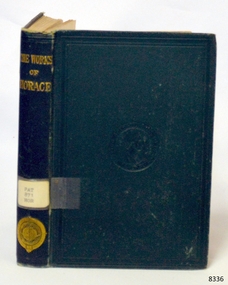
Book - Lyrical Poems, Samuel Lee (Translator), The Works of Horace, 1890
... Lonsdale became widely known in the Victorian educational landscape for his collaborative work with Samuel Lee. ...Lonsdale became widely known in the Victorian educational landscape for his collaborative work with Samuel Lee. ...The original author of this work was Quintus Horatius Flaccus, one of the leading Roman lyric poets during the time of Augustus Caesar (1st century BCE). This volume features the complete surviving works of Horace, rendered entirely into English prose. It includes his famous Odes, or lyrical poems, as well as his earlier poems on politics and social issues of the time. It also features his Satires, which offer humorous commentaries on Roman life, and his Epistles, or letters in verse, which include his highly influential work on literary criticism, the Ars Poetica (or The Art of Poetry).The Works of Horace Author: James Lonsdale and Samuel Lee Publisher: Macmillan And Co Date: 1890 Further Information: non-fictionThe original author of this work was Quintus Horatius Flaccus, one of the leading Roman lyric poets during the time of Augustus Caesar (1st century BCE). This volume features the complete surviving works of Horace, rendered entirely into English prose. It includes his famous Odes, or lyrical poems, as well as his earlier poems on politics and social issues of the time. It also features his Satires, which offer humorous commentaries on Roman life, and his Epistles, or letters in verse, which include his highly influential work on literary criticism, the Ars Poetica (or The Art of Poetry).flagstaff hill, warrnambool, shipwrecked coast, flagstaff hill maritime museum, maritime museum, shipwreck coast, flagstaff hill maritime village, great ocean road, book, pattison collection, warrnambool library, warrnambool mechanics’ institute, ralph eric pattison, corangamite regional library service, warrnambool city librarian, mechanics’ institute library, victorian library board, warrnambool books and records, warrnambool children’s library, the works of horace, samuel lee, james lonsdale, latin translated text -
 Eltham District Historical Society Inc
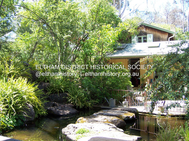
Photograph - Digital Photograph, Marguerite Marshall, Gordon Ford's Garden, 'Fulling', Pitt Street, Eltham, 10 November 2006
... landscape designer, Gordon Ford, who died in 1999. The garden ‘encapsulates the major trends of Australian garden design in the second half of the 20th century...and epitomises the Eltham style of garden’.2 It in turn, was influenced by several Victorian major landscape designers of the mid 20th century – Ellis Stones, Peter Glass and Edna Walling. ...landscape designer, Gordon Ford, who died in 1999. The garden ‘encapsulates the major trends of Australian garden design in the second half of the 20th century...and epitomises the Eltham style of garden’.2 It in turn, was influenced by several Victorian major landscape designers of the mid 20th century – Ellis Stones, Peter Glass and Edna Walling. ...'Fulling', the half-hectare property at Pitt Street, Eltham was the home of landscape designer Gordon Ford and his wife Gwen. Ford bought the property in 1948, originally part of an orchard. The garden encapsulates the major trends of Australian garden design in the second half of the 20th century. The garden design is based on mass (plants) and void (paths and pools), textures and forms. It epitomises the Eltham style because of its relaxed informality and attraction to native wildlife. The mud brick house and designed and built by Ford commenced in 1948. Several extensions were added up to 1970 and were built by Graham Rose (Source: information panel for exhibition, n.d.) Covered under Heritage Overlay, Nillumbik Planning Scheme. Published: Nillumbik Now and Then / Marguerite Marshall 2008; photographs Alan King with Marguerite Marshall.; p147 A narrow timber gate opens onto a garden that has had a huge impact on natural garden development in Australia since the 1950s.1 Fulling, the half-hectare property at Pitt St, Eltham, was the home of the landscape designer, Gordon Ford, who died in 1999. The garden ‘encapsulates the major trends of Australian garden design in the second half of the 20th century...and epitomises the Eltham style of garden’.2 It in turn, was influenced by several Victorian major landscape designers of the mid 20th century – Ellis Stones, Peter Glass and Edna Walling. The gate opens onto a sandy gravel path, one of several, which wind around dramatic pools and what appear to be natural bush, but on close inspection are carefully integrated native, indigenous and exotic plantings. Retaining walls and steps of rock through the garden link different terrace levels. Lichen-covered boulders serve as steps across a pool, leading to the triple level mud-brick house. Ford bought the property, which was originally part of an orchard, in 1948. As the son of a Presbyterian minister, Ford received a good education, which included learning Latin. This was advantageous when he worked in plant sales for the Forestry Commission, before the Second World War. In the late 1940s, however, Ford turned to building and landscape gardening. He worked on the Busst house, an early mud-brick building designed by Alistair Knox and at the same time, Ford was employed by Ellis Stones. Knox described Ford as, ‘one of the funniest men of the district. ...Rocky’s (Ellis Stones) Depression stories and Gordon’s memory and quick tongue made the jobs the most enjoyable of all those hysterical times that made Eltham the centre of the eternal laugh, between the years of 1945 and 1950’.3 Ford’s house, like so many after the war, was built progressively, as more space was needed and formerly scarce materials became available. It began with an army-shed of timber-lined walls, now used as the kitchen. Ford then built what is now the lounge room, and the house grew ‘like topsy and on a shoestring,’ says his widow Gwen. A lot of second-hand materials such as window frames were used, a style made famous particularly with their extensive use at Montsalvat, the Eltham Artists’ Colony. The house was constructed as a joint venture with friends, including artist Clifton Pugh, who built Ford’s bedroom for £10. The polished floorboards and solomite (compressed straw) ceilings, interspersed with heavy beams, exude warmth. The result is a home of snug spaces, with soft light and garden vistas. Several other mud-brick buildings were constructed as needed, including a studio and units for bed-and-breakfast clients. The garden, which has been part of the Open Garden Scheme since the mid 1980s, is based on a balance of mass (plants) and void (paths and pools), textures and forms. It epitomises the Eltham style because of its relaxed informal ethos and attracts native animals. Wattlebirds, scrub wrens, pardalotes, currawongs, owls and even kangaroos, have been seen at Fulling. Gwen, a former English teacher who has worked on the garden since around 1970, urged and helped Ford write his book, The Natural Australian Garden.4 Several of Ford’s favourite trees are in the garden, including the native Casuarina or She-Oak. In spring, the garden is dusted with the purple Orthrosanthus multiflorus or blue native irises and rings with the calls of birds attracted to plants like the callistemons, correas and grevilleas.This collection of almost 130 photos about places and people within the Shire of Nillumbik, an urban and rural municipality in Melbourne's north, contributes to an understanding of the history of the Shire. Published in 2008 immediately prior to the Black Saturday bushfires of February 7, 2009, it documents sites that were impacted, and in some cases destroyed by the fires. It includes photographs taken especially for the publication, creating a unique time capsule representing the Shire in the early 21st century. It remains the most recent comprehenesive publication devoted to the Shire's history connecting local residents to the past. nillumbik now and then (marshall-king) collection, eltham, fulling, gordon ford garden, pitt street, eltham mud brick buildings, mud brick house -
 Kiewa Valley Historical Society
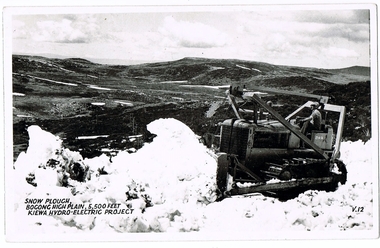
Postcard Circa 1950, Snow Plough, Bogong High Plain,5,500 Feet Kiewa Hydro-Electric Project, Circa 1950
... The Victorian Alps and the rivers flowing into its valleys was ideal for the construction of the Kiewa Hydro Electricity Scheme. The late 1940's saw the development of this scheme and the changing of sections of alpine landscape is covered by this and other postcards/pictures (tourists, construction workers, and established rural populations). ...The Victorian Alps and the rivers flowing into its valleys was ideal for the construction of the Kiewa Hydro Electricity Scheme. The late 1940's saw the development of this scheme and the changing of sections of alpine landscape is covered by this and other postcards/pictures (tourists, construction workers, and established rural populations). ...This postcard was produced in the 1950's for the tourist trade in the Kiewa Valley and Alpine region. It encompasses the period when the State of Victoria was pressured by the ever increasing demand by industry and its population for electricity supplies. Hydro electricity was seen as an untapped natural resource to quench this demand. The Victorian Alps and the rivers flowing into its valleys was ideal for the construction of the Kiewa Hydro Electricity Scheme. The late 1940's saw the development of this scheme and the changing of sections of alpine landscape is covered by this and other postcards/pictures (tourists, construction workers, and established rural populations). This period in time was before the established wildlife and forest/nature groups became political activist who changed legislative acts to protect the environment. This rural region (Kiewa Valley/alpine plains) was at most only significant to a smaller group of winter sports, summer hikers/horse riders and rural farmers/graziers. The numbers of tourists and the increase in the local resident population was boosted by the construction of the Hydro Electricity Scheme. This influx to the regional population resulted in a corresponding diversity in services and brought about an environment that responded to a growing level of tourists and thereby permitting this industry to grow more rapidly than it would have naturally. This postcard details an attraction to the "cleaner" method of providing electricity. This postcard was purchased in 1950 by a surveyor at Landford's Gap. This item is a black and white photograph(professional) of a panoramic view of a snow plough clearing the unsealed road in 1950.This postcard is on quality paper and the reproduction of the picture is of a high standard.For other "tourist" postcards see 0480 (A) -(F) for other photos of similar postcards. kiewa valley tourism, victorian alps, alternate energy supplies, alpine population growth, secv, snow plough -
 Kiewa Valley Historical Society
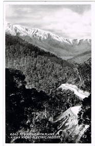
Postcard Circa 1950, Road to Bogong High Plains Kiewa Hydro Electric Project, Circa 1950's
... The Victorian Alps and the rivers flowing into its valleys was ideal for the construction of the Kiewa Hydro Electricity Scheme. The late 1940's saw the development of this scheme and the changing of sections of alpine landscape is covered by this and other postcards/pictures (tourists, construction workers, and established rural populations). ...The Victorian Alps and the rivers flowing into its valleys was ideal for the construction of the Kiewa Hydro Electricity Scheme. The late 1940's saw the development of this scheme and the changing of sections of alpine landscape is covered by this and other postcards/pictures (tourists, construction workers, and established rural populations). ...This postcard was produced in the 1950's for the tourist trade in the Kiewa Valley and Alpine region. It encompasses the period when the State of Victoria was pressured by the ever increasing demand by industry and its population for electricity supplies. Hydro electricity was seen as an untapped natural resource to quench this demand. The Victorian Alps and the rivers flowing into its valleys was ideal for the construction of the Kiewa Hydro Electricity Scheme. The late 1940's saw the development of this scheme and the changing of sections of alpine landscape is covered by this and other postcards/pictures (tourists, construction workers, and established rural populations). This period in time was before the established wildlife and forest/nature groups became political activist who changed legislative acts to protect the environment.This rural region (Kiewa Valley/alpine plains) was at most only significant to a smaller group of winter sports, summer hikers/horse riders and rural farmers/graziers. The numbers of tourists and the increase in the local resident population was boosted by the construction of the Hydro Electricity Scheme. This influx to the regional population resulted in a corresponding diversity in services and brought about an environment that responded to a growing level of tourists and thereby permitting this industry to grow more rapidly than it would have naturally. This postcard details an attraction to the "cleaner" method of providing electricity. This postcard was purchased in 1950 by a surveyor at Landford's Gap.This black and white photograph on a Valentine's postcard is from a V2 Argus photograph.. It is on a 200g/m paper density photo side gloss. See 0480 (A) - (G) for other photos of similar postcards.In white lettering " ROAD TO BOGONG HIGH PLAINS KIEWA HYDRO-ELECTRIC PROJECT", V3secv, road making, victorian alps -
 Kiewa Valley Historical Society
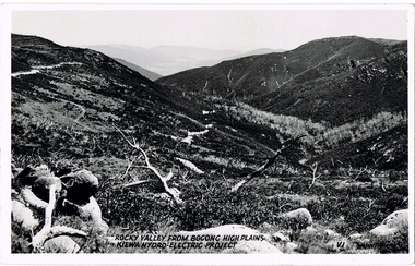
Postcard - Rocky Valley - Circa 1950, 1950
... The Victorian Alps and the rivers flowing into its valleys was ideal for the construction of the Kiewa Hydro Electricity Scheme. The late 1940's saw the development of this scheme and the changing of sections of alpine landscape is covered by this and other postcards/pictures (tourists, construction workers, and established rural populations). ...The Victorian Alps and the rivers flowing into its valleys was ideal for the construction of the Kiewa Hydro Electricity Scheme. The late 1940's saw the development of this scheme and the changing of sections of alpine landscape is covered by this and other postcards/pictures (tourists, construction workers, and established rural populations). ...This postcard was produced in the 1950's for the tourist trade in the Kiewa Valley and Alpine region. It encompasses the period when the State of Victoria was pressured by the ever increasing demand by industry and its population for electricity supplies. Hydro electricity was seen as an untapped natural resource to quench this demand. The Victorian Alps and the rivers flowing into its valleys was ideal for the construction of the Kiewa Hydro Electricity Scheme. The late 1940's saw the development of this scheme and the changing of sections of alpine landscape is covered by this and other postcards/pictures (tourists, construction workers, and established rural populations). This period in time was before the established wildlife and forest/nature groups became political activist who changed legislative acts to protect the environment.This rural region (Kiewa Valley/alpine plains) was at most only significant to a smaller group of winter sports, summer hikers/horse riders and rural farmers/graziers. The numbers of tourists and the increase in the local resident population was boosted by the construction of the Hydro Electricity Scheme. This influx to the regional population resulted in a corresponding diversity in services and brought about an environment that responded to a growing level of tourists and thereby permitting this industry to grow more rapidly than it would have naturally. This postcard details an attraction to the "cleaner" method of providing electricity. This postcard was purchased in 1950 by a surveyor at Landford's Gap.This black and white photograph is from a Valentine's V2 Argus postcard. It is on a 200g/m paper density one side gloss. See also KVHS 0480 (A) to (L) for similar postcards. "ROCKY VALLEY FROM BOGONG HIGH PLAINS KIEWA HYDRO-ELECTRIC PROJECT" "V1"kiewa valley tourism, victorian alps, alternate energy supplies, alpine population growth, rocky valley, secv -
 Kiewa Valley Historical Society
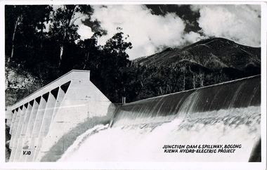
Postcard - Junction Dam - Circa 1950, Circa 1950's
... The Victorian Alps and the rivers flowing into its valleys was ideal for the construction of the Kiewa Hydro Electricity Scheme. The late 1940's saw the development of this scheme and the changing of sections of alpine landscape is covered by this and other postcards/pictures (tourists, construction workers, and established rural populations). ...The Victorian Alps and the rivers flowing into its valleys was ideal for the construction of the Kiewa Hydro Electricity Scheme. The late 1940's saw the development of this scheme and the changing of sections of alpine landscape is covered by this and other postcards/pictures (tourists, construction workers, and established rural populations). ...This postcard was produced in the 1950's for the tourist trade in the Kiewa Valley and Alpine region. It encompasses the period when the State of Victoria was pressured by the ever increasing demand by industry and its population for electricity supplies. Hydro electricity was seen as an untapped natural resource to quench this demand. The Victorian Alps and the rivers flowing into its valleys was ideal for the construction of the Kiewa Hydro Electricity Scheme. The late 1940's saw the development of this scheme and the changing of sections of alpine landscape is covered by this and other postcards/pictures (tourists, construction workers, and established rural populations). This period in time was before the established wildlife and forest/nature groups became political activist who changed legislative acts to protect the environment.This rural region (Kiewa Valley/alpine plains) was at most only significant to a smaller group of winter sports, summer hikers/horse riders and rural farmers/graziers. The numbers of tourists and the increase in the local resident population was boosted by the construction of the Hydro Electricity Scheme. This influx to the regional population resulted in a corresponding diversity in services and brought about an environment that responded to a growing level of tourists and thereby permitting this industry to grow more rapidly than it would have naturally. This postcard details an attraction to the "cleaner" method of providing electricity. This postcard was purchased in 1950 by a surveyor at Landford's Gap.This black and white photograph is a Valentine's postcard, from a V2 Argus photograph. It is on a 200g/m paper density with only the photo side gloss.Front "JUNCTION DAM & SPILLWAY, BOGONG KIEWA HYDRO-ELECTRIC PROJECT" on the flip side "VALENTINE'S POST CARD " "A GENUINE PHOTOGRAPH"kiewa valley tourism, victorian alps, alternate energy supplies, alpine population growth, junction dam, secv -
 Kiewa Valley Historical Society
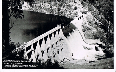
Postcard - Junction Dam - Circa 1950, Circa 1950
... The Victorian Alps and the rivers flowing into its valleys was ideal for the construction of the Kiewa Hydro Electricity Scheme. The late 1940's saw the development of this scheme and the changing of sections of alpine landscape is covered by this and other postcards/pictures (tourists, construction workers, and established rural populations). ...The Victorian Alps and the rivers flowing into its valleys was ideal for the construction of the Kiewa Hydro Electricity Scheme. The late 1940's saw the development of this scheme and the changing of sections of alpine landscape is covered by this and other postcards/pictures (tourists, construction workers, and established rural populations). ...This postcard was produced in the 1950's for the tourist trade in the Kiewa Valley and Alpine region. It encompasses the period when the State of Victoria was pressured by the ever increasing demand by industry and its population for electricity supplies. Hydro electricity was seen as an untapped natural resource to quench this demand. The Victorian Alps and the rivers flowing into its valleys was ideal for the construction of the Kiewa Hydro Electricity Scheme. The late 1940's saw the development of this scheme and the changing of sections of alpine landscape is covered by this and other postcards/pictures (tourists, construction workers, and established rural populations). This period in time was before the established wildlife and forest/nature groups became political activist who changed legislative acts to protect the environment.This rural region (Kiewa Valley/alpine plains) was at most only significant to a smaller group of winter sports, summer hikers/horse riders and rural farmers/graziers. The numbers of tourists and the increase in the local resident population was boosted by the construction of the Hydro Electricity Scheme. This influx to the regional population resulted in a corresponding diversity in services and brought about an environment that responded to a growing level of tourists and thereby permitting this industry to grow more rapidly than it would have naturally. This postcard details an attraction to the "cleaner" method of providing electricity. This postcard was purchased in 1950 by a surveyor at Landford's Gap.This black and white photograph on a Valentine's postcard is from a V2 Argus photograph. It is on a 200g/m paper density one side gloss only/. See 0480 (A) -(L) for other photos of similar postcards."JUNCTION DAM & SPILLWAY, LAKE GUY, BOGONG, KIEWA HYDRO-ELECTRIC PROJECT" "V5" on the flip side" VALENTINE'S POST CARD " "A GENUINE PHOTOGRAPH"kiewa valley tourism, victorian alps, alternate energy supplies, alpine population growth, junction dam, secv -
 Kiewa Valley Historical Society
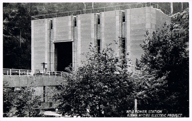
Postcard Circa 1950, No.3 Power Station Kiewa Hydro-electric Project "V.8", Circa 1950
... The Victorian Alps and the rivers flowing into its valleys was ideal for the construction of the Kiewa Hydro Electricity Scheme. The late 1940's saw the development of this scheme and the changing of sections of alpine landscape is covered by this and other postcards/pictures (tourists, construction workers, and established rural populations). ...The Victorian Alps and the rivers flowing into its valleys was ideal for the construction of the Kiewa Hydro Electricity Scheme. The late 1940's saw the development of this scheme and the changing of sections of alpine landscape is covered by this and other postcards/pictures (tourists, construction workers, and established rural populations). ...This postcard was produced in the 1950's for the tourist trade in the Kiewa Valley and Alpine region. It encompasses the period when the State of Victoria was pressured by the ever increasing demand by industry and its population for electricity supplies. Hydro electricity was seen as an untapped natural resource to quench this demand. The Victorian Alps and the rivers flowing into its valleys was ideal for the construction of the Kiewa Hydro Electricity Scheme. The late 1940's saw the development of this scheme and the changing of sections of alpine landscape is covered by this and other postcards/pictures (tourists, construction workers, and established rural populations). This period in time was before the established wildlife and forest/nature groups became political activist who changed legislative acts to protect the environment.This rural region (Kiewa Valley/alpine plains) was at most only significant to a smaller group of winter sports, summer hikers/horse riders and rural farmers/graziers. The numbers of tourists and the increase in the local resident population was boosted by the construction of the Hydro Electricity Scheme. This influx to the regional population resulted in a corresponding diversity in services and brought about an environment that responded to a growing level of tourists and thereby permitting this industry to grow more rapidly than it would have naturally. This postcard details an attraction to the "cleaner" method of providing electricity. This postcard was purchased in 1950 by a surveyor at Landford's Gap.This black and white photograph from a Valentine's postcard is from a V2 Argus photograph postcard. It is on a 200g/m paper density photo side gloss. See 0480 (A) - (K) for other photos of similar postcards."No.3 POWER STATION KIEWA HYDRO ELECTRIC PROJECT" "V8"kiewa valley tourism, victorian alps, alternate energy supplies, alpine population growth, secv -
 Kiewa Valley Historical Society
Book - English Reader, The Victorian Readers Fifth Book, 1940
... victorian education department. tawonga. davies. louden. reader. Inside front cover: Ann Louden On title page: G. Davies Pale coloured pinkish plastic with white landscape picture in white on it covers the hard covered book. ...This book was supplied by the Victorian Education Department for all Grade 5 students at Government schools. Each student had one including the local family who passed it on to another family member. Books were covered to protect them. In this case a stiff, dull plastic.Historical: Used by grade 5 students in Victorian Government Schools. Provenance: Used and handed down to family members in Tawonga where they lived and went to school.Pale coloured pinkish plastic with white landscape picture in white on it covers the hard covered book. Parts of the plastic have small tears and is wrinkled. Inside front cover: Ann Louden On title page: G. Daviesprimary school. education. victorian education department. tawonga. davies. louden. reader. -
 Kiewa Valley Historical Society
Mug Stoneware
... Victorian Alpine Region. Due to the connections Bill Waters has with the Bogong High Plains and Mt Bogong this cup has a lot of significance to the social history of the area.. fowler ceramics local alpine history alpine rovers scouts mugs mt bogong bogong high plains Written inscription on the front "Bill Bogong's Mug" in large print and beneath it, in smaller print, "with compliments from Flinders Petrie Rover Crew" The other side of the mug is a free hand landscaped drawing of green bush and blue hills with a tree supporting a tent and a camp fire (with smoke rising from it).To the left of the inscription is the Scout (Rover) emblem coloured black with an unraveled and unwritten signage scroll Round glazed stoneware mug, white in colour, with a heritage green coloured band covering the top rim and handle. ...This ceramic mug is titled "Bill Bogong's Mug" in honour of one of Australia's Scouting (Rovers) notable office holders, Mr.W.F."Bill" Waters. He was born on 22nd August 1897 in Taralgon, Victoria, Australia and died 8th October 1968 in Fitzroy, Victoria. He was instrumental in the Rovers building two chalets in the Victorian Alps. The Victorian Award of the National Rover Service Award(1980) has been named after Bill Waters. Bill Waters was also the leader of the first team that climbed Mount Bogong in winter in 1929. Also was part of rescue team of what is now know as the Cleve Cole tragedy on Mt Bogong in the mid 1930's. There is also a water fall named after him Waters Falls on the Bogong High Plains. W.F."Bill" Waters aka "Bill Bogong" (Bogong mountain, were his ashes were scattered), was not only a prominent bush walker (Melbourne Walking Club) of the high country (Victorian Alps) but was instrumental in establishing two Chalets. One of these Chalets was the first one to be built on the Bogong High Plains. This item, "Bill Bogong's Mug" is what the Flinders Petrie(famous English Egyptologist/Archaelogist) Rover Crew(formed in 1940) presented newly invested members of the exclusive(200 membership) Alpine Rover Crew. The Melbourne Walking Club has a long history with the Victorian High Plains area, of which the Kiewa Valley is an integral part of the Victorian Alpine Region. Due to the connections Bill Waters has with the Bogong High Plains and Mt Bogong this cup has a lot of significance to the social history of the area.. Round glazed stoneware mug, white in colour, with a heritage green coloured band covering the top rim and handle. Written inscription on the front "Bill Bogong's Mug" in large print and beneath it, in smaller print, "with compliments from Flinders Petrie Rover Crew" The other side of the mug is a free hand landscaped drawing of green bush and blue hills with a tree supporting a tent and a camp fire (with smoke rising from it).To the left of the inscription is the Scout (Rover) emblem coloured black with an unraveled and unwritten signage scroll fowler ceramics, local alpine history, alpine rovers, scouts, mugs, mt bogong, bogong high plains -
 Kiewa Valley Historical Society
Postcard Circa 1950, Howman Gap Hostel under snow Kiewa Hydro-Electric Project, Circa 1950
... The Victorian Alps and the rivers flowing into its valleys was ideal for the construction of the Kiewa Hydro Electricity Scheme. The late 1940's saw the development of this scheme and the changing of sections of alpine landscape is covered by this and other postcards/pictures (tourists, construction workers, and established rural populations). ...The Victorian Alps and the rivers flowing into its valleys was ideal for the construction of the Kiewa Hydro Electricity Scheme. The late 1940's saw the development of this scheme and the changing of sections of alpine landscape is covered by this and other postcards/pictures (tourists, construction workers, and established rural populations). ...This postcard was produced in the 1950's for the tourist trade in the Kiewa Valley and Alpine region. It encompasses the period when the State of Victoria was pressured by the ever increasing demand by industry and its population for electricity supplies. Hydro electricity was seen as an untapped natural resource to quench this demand. The Victorian Alps and the rivers flowing into its valleys was ideal for the construction of the Kiewa Hydro Electricity Scheme. The late 1940's saw the development of this scheme and the changing of sections of alpine landscape is covered by this and other postcards/pictures (tourists, construction workers, and established rural populations). This period in time was before the established wildlife and forest/nature groups became political activist who changed legislative acts to protect the environment.This rural region (Kiewa Valley/alpine plains) was at most only significant to a smaller group of winter sports, summer hikers/horse riders and rural farmers/graziers. The numbers of tourists and the increase in the local resident population was boosted by the construction of the Hydro Electricity Scheme. This influx to the regional population resulted in a corresponding diversity in services and brought about an environment that responded to a growing level of tourists and thereby permitting this industry to grow more rapidly than it would have naturally. This postcard details an attraction to the "cleaner" method of providing electricity. This postcard was purchased in 1950 by a surveyor at Landford's Gap.This item is a scanned black and white photograph of a panoramic view of Howman Gap Hostel under snow in 1950 (a closed village, entry by pass only). This accommodation was for construction workers only. See 0480 (A) -(E) for other photos of similar postcards.On the photo, " Howman Gap Hostel under snow Kiewa Hydro-Electric Project" . On postcard address and personal information side "V.2 Valentine's Post Card "kiewa valley tourism, victorian alps, alternate energy supplies, alpine population growth, bogong, secv, howman's gap hostel -
 Kiewa Valley Historical Society
Photograph Farm Land, Mount Beauty Acreage before Golf Course, Circa 1950
... Victorian State Electricity Commission. This photograph details a dramatic period in time which saw an enormous change to the exclusively rural area of the Kiewa Valley region in the mid 1900s. This change presented both physical and mental challenges to the existing quiet rural inhabitants of the valley. The State of Victoria had to make adjustments to the changing demands imposed by population and industrial expansions. The development of cleaner energy supplies to a growing population has its downside ,which ever way the intrusion into the "natural" landscape ...This photograph is a "snap shot" in time circa 1950s detailing the rural environment before the effects of the Kiewa Valley Hydro Scheme altered the basic rural setting of the valley. The golfing fairway was being mapped out on previous grazing land, before the laying of a golf course, for use by the construction workers and auxiliary administration employees of the Victorian State Electricity Commission. This photograph details a dramatic period in time which saw an enormous change to the exclusively rural area of the Kiewa Valley region in the mid 1900s. This change presented both physical and mental challenges to the existing quiet rural inhabitants of the valley. The State of Victoria had to make adjustments to the changing demands imposed by population and industrial expansions. The development of cleaner energy supplies to a growing population has its downside ,which ever way the intrusion into the "natural" landscape is made.Black and white photograph detailing surveyor posts for construction of golf course. Land used, before establishment of the Mount Beauty Village, as farming/grazing cattle and viewed towards Mount Bogong and its Alpine ranges. The photo is on 200gms paper and not on photographic paper.nilmount beauty in the 1940s - 1950s, grazing in the kiewa valley, sec victoria -
 Kiewa Valley Historical Society
Photograph Transmission lines Mount Beauty, 66 KVA Transmission lines from Clover Power Station, Circa 1950
... This photograph shows the beginning of the accommodation and administration buildings for use by the construction workers and auxiliary administration employees of the Victorian State Electricity Commission. It also provides a view of the landscape before extensive development of Pondage and other non rural buildings....This photograph shows the beginning of the accommodation and administration buildings for use by the construction workers and auxiliary administration employees of the Victorian State Electricity Commission. It also provides a view of the landscape before extensive development of Pondage and other non rural buildings. ...This photograph is a "snap shot" in time circa 1950s detailing the rural environmental change and the progressive effects of the Kiewa Valley Hydro Scheme on the basic rural setting of the valley (note the sparsity of rural infrastructure). This photograph shows the beginning of the accommodation and administration buildings for use by the construction workers and auxiliary administration employees of the Victorian State Electricity Commission. It also provides a view of the landscape before extensive development of Pondage and other non rural buildings.This photograph details a dramatic period in time which saw an enormous change to the exclusively rural area of the Kiewa Valley region in the mid 1900s (see sparse rural buildings/houses). This change presented both physical and mental challenges to the existing quiet rural inhabitants of the valley. The State of Victoria had to make adjustments to the changing demands imposed by population and industrial expansions. The development of cleaner energy supplies to a growing population has its downside ,which ever way the intrusion into the "natural" landscape is made. The construction of the large Pondage at the centre of the photograph is a good example.This black and white photograph of a panoramic view of the Kiewa Valley (Mount Beauty SEC construction workers village) shows the newly completed transmission line towers delivering electrical power(66KVA) from the Clover Power Station. The photo is on 200gms paper and not on special photographic paper.mount beauty 1940 to 1950s, development of sec kiewa hydro scheme, sec victoria -
 Kiewa Valley Historical Society
Photograph of Snow Covered Catchment Area Vic, Snow Covered Catchment Area Victorian Alps - 1950s, Circa 1950
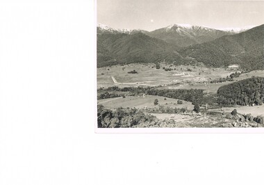
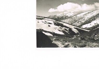
... This photograph details (early to mid1950s), the Victorian Alpine region when this remote area was part of a "lay back" rural landscape,occasionally visited by recreational adventurers and some wayward tourists. ...Kiewa Valley Historical Society Mount Beauty Information Centre 31 Bogong High Plains Rd Mt Beauty high-country This photograph details (early to mid1950s), the Victorian Alpine region when this remote area was part of a "lay back" rural landscape,occasionally visited by recreational adventurers and some wayward tourists. ...This photograph details (early to mid1950s), the Victorian Alpine region when this remote area was part of a "lay back" rural landscape,occasionally visited by recreational adventurers and some wayward tourists. The mountain ranges had provided an adequate barrier against the way-would traveller, but with the opening up of this region by the provision of improved roadways and accommodation facilities, courtesy of the Kiewa Valley Hydro Electricity Scheme, changes such as tourism and its impact upon the "natural" state started to show its side effects (clearing of the land). The expansion of the European immigration numbers (1950s) coming into Australia was increasing after World War II which not only provided increased construction workers to the region but also immigrants who appreciated alpine regions. Some of these immigrants contributed to the expansion of the region and provided for a greater degree of diverse professions and rural related work force.This photograph depicts the borderline in time between an exclusively rural based population and respective activities(early 1900s)to the present (2000 on wards) integrated village, tourist and retiree/holiday area. The time when land was exclusively used in agriculture and Alpine grazing lands is over. The Kiewa Valley is loosing its hiding place and is becoming more and more a source of untapped residential land and winter time recreational adventure lands. The changes brought about by modern technologies involving recreational activities such as hang gliding, gliding (local airstrip), mountain bikes, car rallies and their associated clubs is providing for an increased short term population boost. These together with the attractions for retirees is changing not only the physical nature of the Kiewa valley but also its "soul".This item is a black and white photograph of a section of snow covered catchment area in the Victorian Alps in the mid 1900. It is on 200 gms paper but not on photographic paper and has a white boarder (3 mm).kiewa valley tourism, victorian alps, alternate energy supplies, alpine population growth -
 Emerald Museum & Nobelius Heritage Park
Plaque - Opening Plaque of Emerald Recreation Reserve Pavilion, 1965
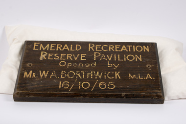
... Victorian Legislative Assembly representing the electorate of Scoresby. It was built to serve the needs of local sports teams including the Emerald Cricket Club. The 1965 pavilion was replaced in 2021. This plaque commemorates a now-renovated building playing an important role in facilitating sporting and recreation in the local community over more than five decades. Emerald Cricket Club Worrell Reserve Painted on wood: "EMERALD RECREATION / RESERVE PAVILION / Opened by / MR. W A. BORTHWICK M.L.A. / 16/10/65" A rectangular wooden plaque, with partially faded text painted on one side in a landscape ...This plaque commemorated the October 16th, 1965 opening of a new pavilion at Emerald Recreation Reserve (now known as Worrell Reserve). The pavilion was opened by Mr William Archibald Borthwick, at that time a member of the Victorian Legislative Assembly representing the electorate of Scoresby. It was built to serve the needs of local sports teams including the Emerald Cricket Club. The 1965 pavilion was replaced in 2021.This plaque commemorates a now-renovated building playing an important role in facilitating sporting and recreation in the local community over more than five decades.A rectangular wooden plaque, with partially faded text painted on one side in a landscape orientation. There are two holes through the display side of the plaque near the middle of each short edge, previously used to affix the plaque to a surface. There is a small taper between the rear side and display side such that the display side is slightly smaller.Painted on wood: "EMERALD RECREATION / RESERVE PAVILION / Opened by / MR. W A. BORTHWICK M.L.A. / 16/10/65"emerald cricket club, worrell reserve -
 Kiewa Valley Historical Society
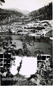
Postcard Circa 1950, Lake Guy Dam and Bogong Village, Circa 1950
... The Victorian Alps and the rivers flowing into its valleys was ideal for the construction of the Kiewa Hydro Electricity Scheme. The late 1940's saw the development of this scheme and the changing of sections of alpine landscape is covered by this and other postcards/pictures (tourists, construction workers, and established rural populations). ...The Victorian Alps and the rivers flowing into its valleys was ideal for the construction of the Kiewa Hydro Electricity Scheme. The late 1940's saw the development of this scheme and the changing of sections of alpine landscape is covered by this and other postcards/pictures (tourists, construction workers, and established rural populations). ...This postcard was produced in the 1950's for the tourist trade in the Kiewa Valley and Alpine region. It encompasses the period when the State of Victoria was pressured by the ever increasing demand by industry and its population for electricity supplies. Hydro electricity was seen as an untapped natural resource to quench this demand. The Victorian Alps and the rivers flowing into its valleys was ideal for the construction of the Kiewa Hydro Electricity Scheme. The late 1940's saw the development of this scheme and the changing of sections of alpine landscape is covered by this and other postcards/pictures (tourists, construction workers, and established rural populations). This period in time was before the established wildlife and forest/nature groups became political activist who changed legislative acts to protect the environment.This rural region (Kiewa Valley/alpine plains) was at most only significant to a smaller group of winter sports, summer hikers/horse riders and rural farmers/graziers. The numbers of tourists and the increase in the local resident population was boosted by the construction of the Hydro Electricity Scheme. This influx to the regional population resulted in a corresponding diversity in services and brought about an environment that responded to a growing level of tourists and thereby permitting this industry to grow more rapidly than it would have naturally. This postcard details an attraction to the "cleaner" method of providing electricity. This postcard was purchased in 1950 by a surveyor at Landford's Gap.This black and white photograph from a Valentine's postcard is from a V2 Argus photograph postcard. It is on a 200g/m paper density photo side gloss. See 0480 (B) - (F) for other photos of similar postcards.In white lettering " LAKE GUY & BOGONG VILLAGE KIEWA HYDRO-ELECTRIC PROJECT"kiewa valley tourism, victorian alps, alternate energy supplies, alpine population growth -
 Kiewa Valley Historical Society
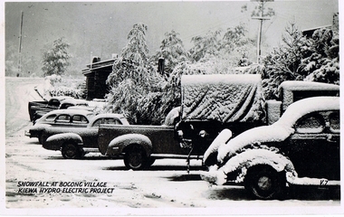
Postcard Circa 1950, Snowfall at Bogong Village Kiewa Hydro-Electric Project, 1950s
... The Victorian Alps and the rivers flowing into its valleys was ideal for the construction of the Kiewa Hydro Electricity Scheme. The late 1940's saw the development of this scheme and the changing of sections of alpine landscape is covered by this and other postcards/pictures (tourists, construction workers, and established rural populations). ...The Victorian Alps and the rivers flowing into its valleys was ideal for the construction of the Kiewa Hydro Electricity Scheme. The late 1940's saw the development of this scheme and the changing of sections of alpine landscape is covered by this and other postcards/pictures (tourists, construction workers, and established rural populations). ...This postcard was produced in the 1950's for the tourist trade in the Kiewa Valley and Alpine region. It encompasses the period when the State of Victoria was pressured by the ever increasing demand by industry and its population for electricity supplies. Hydro electricity was seen as an untapped natural resource to quench this demand. The Victorian Alps and the rivers flowing into its valleys was ideal for the construction of the Kiewa Hydro Electricity Scheme. The late 1940's saw the development of this scheme and the changing of sections of alpine landscape is covered by this and other postcards/pictures (tourists, construction workers, and established rural populations). This period in time was before the established wildlife and forest/nature groups became political activist who changed legislative acts to protect the environment.This rural region (Kiewa Valley/alpine plains) was at most only significant to a smaller group of winter sports, summer hikers/horse riders and rural farmers/graziers. The numbers of tourists and the increase in the local resident population was boosted by the construction of the Hydro Electricity Scheme. This influx to the regional population resulted in a corresponding diversity in services and brought about an environment that responded to a growing level of tourists and thereby permitting this industry to grow more rapidly than it would have naturally. This postcard details an attraction to the "cleaner" method of providing electricity. This postcard was purchased in 1950 by a surveyor at Landford's Gap.This scanned black and white photograph of a postcard, shows vehicles covered in thick snow at Bogong Village in 1950. See 0480(A), (C) - (F) for other similar photos of postcards available at this period."SNOWFALL AT BOGONG VILLAGE KIEWA HYDRO-ELECTRICITY PROJECT"kiewa valley tourism, victorian alps, alternate energy supplies, alpine population growth, bogong village, secv -
 Kiewa Valley Historical Society
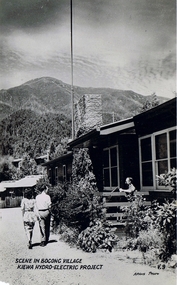
Postcard Circa 1950, Scene in Bogong Village Kiewa Hydro-Electric Project, 1950s
... The Victorian Alps and the rivers flowing into its valleys was ideal for the construction of the Kiewa Hydro Electricity Scheme. The late 1940's saw the development of this scheme and the changing of sections of alpine landscape is covered by this and other postcards/pictures (tourists, construction workers, and established rural populations). ...The Victorian Alps and the rivers flowing into its valleys was ideal for the construction of the Kiewa Hydro Electricity Scheme. The late 1940's saw the development of this scheme and the changing of sections of alpine landscape is covered by this and other postcards/pictures (tourists, construction workers, and established rural populations). ...This postcard was produced in the 1950's for the tourist trade in the Kiewa Valley and Alpine region. It encompasses the period when the State of Victoria was pressured by the ever increasing demand by industry and its population for electricity supplies. Hydro electricity was seen as an untapped natural resource to quench this demand. The Victorian Alps and the rivers flowing into its valleys was ideal for the construction of the Kiewa Hydro Electricity Scheme. The late 1940's saw the development of this scheme and the changing of sections of alpine landscape is covered by this and other postcards/pictures (tourists, construction workers, and established rural populations). This period in time was before the established wildlife and forest/nature groups became political activist who changed legislative acts to protect the environment. This rural region (Kiewa Valley/alpine plains) was at most only significant to a smaller group of winter sports, summer hikers/horse riders and rural farmers/graziers. The numbers of tourists and the increase in the local resident population was boosted by the construction of the Hydro Electricity Scheme. This influx to the regional population resulted in a corresponding diversity in services and brought about an environment that responded to a growing level of tourists and thereby permitting this industry to grow more rapidly than it would have naturally. This postcard details an attraction to the "cleaner" method of providing electricity. This postcard was purchased in 1950 by a surveyor at Landford's Gap. The couple shown in this photograph would have been employed by the S.E.C. under the Kiewa Hydro-Electricity Scheme.This item is a scanned black and white photograph of a couple walking along a gravel street in Bogong Village in 1950. See 0480 (A) ,(B), (D) - (F) for other photos of similar postcards" SCENE IN BOGONG VILLAGE KIEWA HYDRO-ELECTRIC PROJECT"kiewa valley tourism, victorian alps, alternate energy supplies, alpine population growth, bogong, secv -
 Kiewa Valley Historical Society
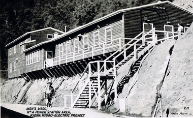
Postcard Circa 1950, Men's Mess No.4 Power Station, Kiewa Hydro-Electric Project
... The Victorian Alps and the rivers flowing into its valleys was ideal for the construction of the Kiewa Hydro Electricity Scheme. The late 1940's saw the development of this scheme and the changing of sections of alpine landscape is covered by this and other postcards/pictures (tourists, construction workers, and established rural populations). ...The Victorian Alps and the rivers flowing into its valleys was ideal for the construction of the Kiewa Hydro Electricity Scheme. The late 1940's saw the development of this scheme and the changing of sections of alpine landscape is covered by this and other postcards/pictures (tourists, construction workers, and established rural populations). ...This postcard was produced in the 1950's for the tourist trade in the Kiewa Valley and Alpine region. It encompasses the period when the State of Victoria was pressured by the ever increasing demand by industry and its population for electricity supplies. Hydro electricity was seen as an untapped natural resource to quench this demand. The Victorian Alps and the rivers flowing into its valleys was ideal for the construction of the Kiewa Hydro Electricity Scheme. The late 1940's saw the development of this scheme and the changing of sections of alpine landscape is covered by this and other postcards/pictures (tourists, construction workers, and established rural populations). This period in time was before the established wildlife and forest/nature groups became political activist who changed legislative acts to protect the environment.Although this photo details the eating facilities of the construction workers at the power station it was not only a postcard for the people employed in the Hydro Scheme is was also provided to tourists visiting the area and thus used for promotional purposes.This rural region (Kiewa Valley/alpine plains) was at most only significant to a smaller group of winter sports, summer hikers/horse riders and rural farmers/graziers. The numbers of tourists and the increase in the local resident population was boosted by the construction of the Hydro Electricity Scheme. This influx to the regional population resulted in a corresponding diversity in services and brought about an environment that responded to a growing level of tourists and thereby permitting this industry to grow more rapidly than it would have naturally. This postcard details an attraction to the "cleaner" method of providing electricity. This postcard was purchased in 1950 by a surveyor at Landford's Gap. The men shown in this photograph would have been employed by the S.E.C. under the Kiewa Hydro-Electricity Scheme.This item is a scanned black and white photograph of a construction worker walking from stairs leading down from the men's mess building, in 1950. See 0480 (A) -(C), (E) - (F) for other photos of similar postcards"MEN'S MESS No.4 POWER STATION AREA, KIEWA HYDRO-ELECTRIC PROJECT" "ARGUS PHOTO V.IIkiewa valley tourism, victorian alps, alternate energy supplies, alpine population growth, secv -
 Kiewa Valley Historical Society
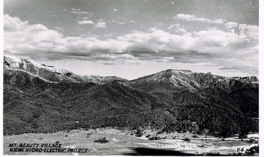
Postcard Circa 1950, Mt. Beauty Village, Kiewa Hydro-Electricity Project, circa 1950
... The Victorian Alps and the rivers flowing into its valleys was ideal for the construction of the Kiewa Hydro Electricity Scheme. The late 1940's saw the development of this scheme and the changing of sections of alpine landscape is covered by this and other postcards/pictures (tourists, construction workers, and established rural populations). ...The Victorian Alps and the rivers flowing into its valleys was ideal for the construction of the Kiewa Hydro Electricity Scheme. The late 1940's saw the development of this scheme and the changing of sections of alpine landscape is covered by this and other postcards/pictures (tourists, construction workers, and established rural populations). ...This postcard was produced in the 1950's for the tourist trade in the Kiewa Valley and Alpine region. It encompasses the period when the State of Victoria was pressured by the ever increasing demand by industry and its population for electricity supplies. Hydro electricity was seen as an untapped natural resource to quench this demand. The Victorian Alps and the rivers flowing into its valleys was ideal for the construction of the Kiewa Hydro Electricity Scheme. The late 1940's saw the development of this scheme and the changing of sections of alpine landscape is covered by this and other postcards/pictures (tourists, construction workers, and established rural populations). This period in time was before the established wildlife and forest/nature groups became political activist who changed legislative acts to protect the environment. The regulatory pondage on the northern aspect of the village had no water over-spill from the unfinished power station.This rural region in 1950 (Kiewa Valley/alpine plains) was at most only significant to a smaller group of winter sports, summer hikers/horse riders and rural farmers/graziers. The numbers of tourists and the increase in the local resident population was boosted by the construction of the Hydro Electricity Scheme. This influx to the regional population resulted in a corresponding diversity in services and brought about an environment that responded to a growing level of tourists and thereby permitting this industry to grow more rapidly than it would have naturally. This postcard details an attraction to the "cleaner" method of providing electricity. This postcard was purchased in 1950 by a surveyor at Landford's Gap. The couple shown in this photograph would have been employed by the S.E.C. under the Kiewa Hydro-Electricity Scheme.This item is a scanned black and white photograph of a panoramic view of Mount Beauty Village in 1950 (a closed village, entry by pass only). The regulatory pondage has earthen walls but no water.See 0480 (A) -(D) and (F) for other photos of similar postcards"MT. BEAUTY VILLAGE KIEWA HYDRO-ELECTRIC PROJECT"kiewa valley tourism, victorian alps, alternate energy supplies, alpine population growth -
 Kiewa Valley Historical Society
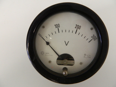
Meter Volt, mid to late 1900's
... This evolution in the valley created a change, not only in the "physical" landscape but also the socio-economic expansion which permitted other "tourist" based industries into the valley. kiewa valley tourism victorian alps alternate energy supplies alpine population growth Manufacturer's logo "CSG" underneath "ITALIA" This analog volt meter has two metal rods protruding from the "back" of instrument with screw on points for the negative and the positive leads allowing the "current" to flow across the calibrated resistors to indicate on the "face" side the strength of the voltage "power". ...This analog voltmeter is quite a large (industrial type) apparatus which permits the easy monitoring of electrical variations within the large SEC Victoria Hydro Scheme's electrical generators. These generators are powered by the hydro force of "stored" water at a higher altitude. The establishment of both the NSW and Victorian Hydro schemes was achieved from the mid 1900's to the 1960's. At this point in time the need for additional power sources to quench both an industrial and domestic demand for electricity was purely an economic and not and environmental (carbon reduction) factor. This hydro scheme was instigated by "the Government of the day" as a bold move and was the major force of the World War II refugee and "technical" workforce inclusion of skilled and unskilled migration into the Australian environment. Although this mass "invasion" of workers with families was thought of in some circles as intrusive, the expansion of population post war years and its integration into the Australian rural sector, produced the multi- lingual multi-cultural diversity of later years. This voltmeter is very significant to the Kiewa Valley as its use was introduced during the Kiewa Hydro Scheme. Although only a small apparatus it was part of the explosion of human resources into the valley. This influx of population transformed the region from that of a basically quiet rural region to one which evolved into both an industrial and a larger residential community. This evolution in the valley created a change, not only in the "physical" landscape but also the socio-economic expansion which permitted other "tourist" based industries into the valley. This analog volt meter has two metal rods protruding from the "back" of instrument with screw on points for the negative and the positive leads allowing the "current" to flow across the calibrated resistors to indicate on the "face" side the strength of the voltage "power". The "face" of the instrument has a zero point and then five evenly graduated marks from Zero to the "100, 200 and 300" marked points of measures. A large "V" below these pointers indicates that they represent levels of voltage. Three small screws hold the "face" in place. At the back of the meter is an aluminium "clasp" with three protruding screws (positioning fasteners) and a a screw tightening fixture for the correct fastening of the "clasp" into the correction location on the meter "board".Manufacturer's logo "CSG" underneath "ITALIA"kiewa valley tourism, victorian alps, alternate energy supplies, alpine population growth -
 Kiewa Valley Historical Society
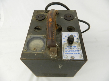
Transformer Lamp System, late 1950's
... landscape but also the socio-economic expansion which permitted other "tourist" based industries into the valley. This is also a specific electronic item which was manufactured in Melbourne and not sourced from Europe or Asia. This demonstrates the fast evolution of Australian technology to a high standard compatible to that of the rest of the world. kiewa hydro electricity scheme victorian state electricity commission transformers On one side is a manufacturer's plaque with "ELECTRONIC A & R EQUIPMENT MELBOURNE" and underneath "TYPE 1719, PRI V. 180 250" underneath "V.A. 1250" underneath "CYC 50" underneath "SEC V. 115" underneath "SEC A. 10 . 8". ...This transformer lamp system, which has a dial to transform 240 volts to a minimum of 32 volts was used by electrical technicians to inspect internal parts of the large generators (even in small confined spaces). The reason for the reduction of the 240 volts to the 32 volts was for the safety of the inspector. The SEC Victoria Hydro Scheme's electrical generators are powered by the hydro force of "stored" water at a higher altitude. The establishment of both the NSW and Victorian Hydro schemes was achieved from the mid 1900's to the 1960's. At this the point in time the need for additional power sources to quench both an industrial and domestic demand for electricity was purely an economic and not and environmental (carbon reduction) factor. This hydro scheme was instigated by "the Government of the day" as a bold move and was the major force of the World War II refugee and "technical" workforce inclusion of skilled and unskilled migration into the Australian environment. Although this mass "invasion" of workers with families was thought of in some circles as intrusive, the expansion of population post war years and its integration into the Australian rural sector, produced the multi- lingual multi-cultural diversity of later years.This transformer lamp is very significant to the Kiewa Valley as it was introduced as a very small part of the explosion of human resources into the valley. This influx of population transformed the region from that of a basically quiet rural region to one which evolved into both industrial and larger residential community. This evolution in the valley created a change, not only in the "physical" landscape but also the socio-economic expansion which permitted other "tourist" based industries into the valley. This is also a specific electronic item which was manufactured in Melbourne and not sourced from Europe or Asia. This demonstrates the fast evolution of Australian technology to a high standard compatible to that of the rest of the world.This heavy hand held electrical transformer (transforms 240 volts to 32 Volts) an has one leather handle on the top with three small (gauze filtered) air holes. It also has two 2 pin directional cable distribution (clipsal) in/out points 10amps / 240 volts. There is one glassed in volts/ac meter and one variable switch (180 to 150 voltage in settings of 10 volt increments.There are two vents (one on each of the smaller sides). There is also one three pin electrical lead coming out from the top.On one side is a manufacturer's plaque with "ELECTRONIC A & R EQUIPMENT MELBOURNE" and underneath "TYPE 1719, PRI V. 180 250" underneath "V.A. 1250" underneath "CYC 50" underneath "SEC V. 115" underneath "SEC A. 10 . 8". The label on topside "CAUTION SET SWITCH TO 250 v BEFORE CONNECTING TO MAINS THEN, WITH EQUIPMENT OPERATING, SET METER TO RED LINE.kiewa hydro electricity scheme, victorian state electricity commission, transformers -
 Kiewa Valley Historical Society
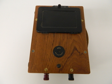
Meter Millivolt, after 1950
... This evolution in the Kiewa Valley created a change, not only in the "physical" landscape(better roads and infrastructure), but also the socio-economic growth within the Valley allowing other "tourist" based industries to expand within the valley and Alpine areas. kiewa valley tourism victorian alps alternate energy supplies alpine population growth On the face of the millivolt compartment , and at the top "TO BE USED WITH DIAL HORIZONTAL TEMP. ...This milli-volt meter was manufactured after 1950 and used by the SEC Vic (Kiewa Hydro Electricity Scheme) from that date until late 1900's. It was used to measure very small voltages associated with the operation of the various Hydro Generators. The readings were able to be shown by the resistor in use in the current circuit. During this time period, high quality testing instruments were either sourced from Europe or England.This milli-volt meter is very significant to the Kiewa Valley as it was used by those electrical technicians, who were part of the Kiewa Hydro Scheme. An "off spin" from the Scheme was the beginning of an explosion in "human" resources into the Kiewa Valley. This influx of population transformed the region from that of a basically quiet rural region to one which evolved into both industrial and larger residential community. This evolution in the Kiewa Valley created a change, not only in the "physical" landscape(better roads and infrastructure), but also the socio-economic growth within the Valley allowing other "tourist" based industries to expand within the valley and Alpine areas.This millivolts DC meter was used in the 1950's. It is contained in a wooden box and has two coloured (red/black, positive and negative) screw tight knobs which have bake-lite connections. It also has a covered (black tin) view meter marked from zero to 10 millivolts. Underneath this and within a round bake-lite is a small adjustment screw. The top of the box is fastened onto the main structure by six brass screws. The back of the structure is fastened by eight brass screws and there are four small bake-lite rest knobs.On the face of the millivolt compartment , and at the top "TO BE USED WITH DIAL HORIZONTAL TEMP. COEF. +- .08 % PER oC. Underneath the scale "MILLIVOLTS D.C. F.G." (LEAD RESIS. .05 OHMS)" underneath and to the left "MADE IN ENGLAND BY" "EVERSHED & VIGNOLES Ltd" and to the right "No. 857842" underneath Regd. TRADE MARK MEGGERkiewa valley tourism, victorian alps, alternate energy supplies, alpine population growth -
 Kiewa Valley Historical Society
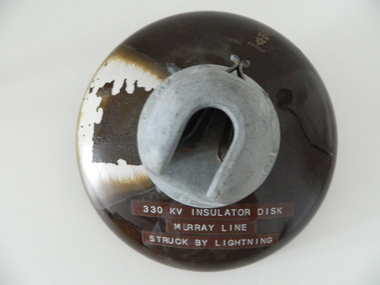
Insulator Disk High Voltage, 1964
... The need for a mountainous and a large area of operational requirements, such as the SEC Vic Kiewa Hydro Electricity Scheme, to distribute the electricity produced in the Victorian Alps to the major users required power transmission lines to "carry" high above the sometimes inaccessible land mass electricity generated at the power stations to the various sub stations along the valleys and ranges to flatter populated regions. The significance of this insulation "high voltage" disk to the Kiewa Valley region relates to the impact of modern technology (at that time) upon a mainly rural environment. These power lines are a stark visual "show" of the impact that the "Scheme" has on the mostly rural landscape ...This insulator disk for the high voltage carrying electrical cables was manufactured in 1964 and used by the SEC Vic (Kiewa Hydro Electricity Scheme) from that date until late 1900's. It was used to connect high voltage cables to their "towers" going from various Hydro Generators to and from power "stations". During this time period, high quality "cable" insulators were manufactured in Japan. In an earlier time they would have been sourced from Europe or England. After the 1950's the sourcing of electrical hardware was being influenced by the lower costs obtainable from Japan. Later on other Asian sources also became available.The need for a mountainous and a large area of operational requirements, such as the SEC Vic Kiewa Hydro Electricity Scheme, to distribute the electricity produced in the Victorian Alps to the major users required power transmission lines to "carry" high above the sometimes inaccessible land mass electricity generated at the power stations to the various sub stations along the valleys and ranges to flatter populated regions. The significance of this insulation "high voltage" disk to the Kiewa Valley region relates to the impact of modern technology (at that time) upon a mainly rural environment. These power lines are a stark visual "show" of the impact that the "Scheme" has on the mostly rural landscape of the Kiewa Valley and what a boost of "modern" equipment into the area has taken place. The "Hydro Scheme" had facilitated the transition of a semi rural area to an advanced rural region within a shorter time frame, than would have taken under "normal" evolutionary time. The speed of information of all "new technology" had a relatively slow assimilation rate before the SEC Kiewa Hydro Scheme came to those living in the then quieter rural communities. This high voltage (330 KV) insulation disk is made from non conductive porcelain stoneware. It is highly polished brown in colour and has a clip fastening for the high voltage cable to be attached to. This disk was hit by lightning and the burn marks are quite noticeable. The top metal connector has a "mushroom" extension jutting below the semi cone like insulation disk. Also four circular ridges or grooves (old 78 rpm disc recording style).Cable bell on top of insulation disk "4K " next to it the international symbol for electricity (triangle containing one horizontal line under one V line and one vertical flame like line.) On the opposite side "2" and to the right "64"sec vic kiewa hydro scheme, alternate energy supplies, alpine (above ground) high voltage electricity cables, volt cable, 330000 volt cable