Showing 15 items matching "warrenheip lead"
-
 Federation University Historical Collection
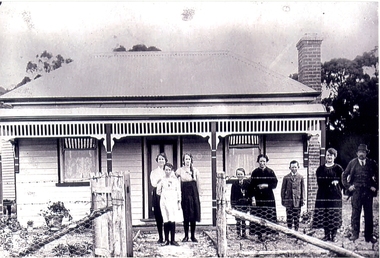
Photograph - Photographs, Images relating to the Vincent Family of Warrenheip and Durham Lead, Victoria
... Images relating to the Vincent Family of Warrenheip and Durham Lead, Victoria...B. .7) Photograph of haystack .8) Photograph of letter from Shire of Buninyong to Mr R Vincent regarding the naming of Vincent Road .9) Photographs of newspaper clippings concerning Cr Vincent becoming the next Buninyong President Images relating to the Vincent Family of Warrenheip and Durham Lead, Victoria Photograph Photographs ...Richard and Amelia (Job) Vincent arrived from Cornwall in 1855. richard was a farmer at Warrenheip. Their children were Richard, Mary, Thomas Job (died in infancy), Thomas Job, Annie, Emily, Selina, Amelia, Ada and George. Annie Vincent married Edward huggins in 1884. Their children were Edith, Robert, Ada, George, Stella, Roy, Lillian, Harold and Ronald. Vincent Avenue, Mount Helen, is named after this family.Provides a record of the descendants of Richard and Amelia Vincent who arrived from Cornwall England in 1855 and became farmers at Warrenheip. Photographs capture dimensions of the life of Councillor Richard Vincent, who became President of the Buninyong Shire Council in 1953.Black and white and colour photographs of people, letters and newspaper clippings depicting dimensions of the Vincent family history .1) Photograph of Vincent family home .2) Photograph of the Bungaree and District Historical Society Heritage Wall .3) Photograph of the Vincent family plaque on the Bungaree and District Historical Society Heritage Wall .4) Photograph of information about the Bungaree and District Historical Society Heritage Wall .5) Photograph of local football l team .6) Photograph of the Mt Buninyong R. F. B. .7) Photograph of haystack .8) Photograph of letter from Shire of Buninyong to Mr R Vincent regarding the naming of Vincent Road .9) Photographs of newspaper clippings concerning Cr Vincent becoming the next Buninyong President richard vincent, haystack, warrenheip, buninyong shire council, amelia vincent, bungaree pioneers wall, mt buninyong rural ire brigade, warrenheip football club, vincent, family history, genealogy -
 Federation University Historical Collection
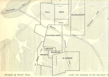
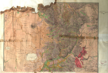
Plan, Underground Survey of Mines, Ballarat East, 1885, 09/1889
... ...warrenheip lead...Surveyed by Robert Allan under the direction of the Secretary of Mines. ballarat east mines mining underground survey robert allan chinese ah chong ah young bakery hill black hill black hill lead bakery hill lead cricket pennyweight hill gravel pitts lead golden point lead navy jack's lead mopoke lead eureka lead association lead warrenheip lead cgt plans Rectangular plan showing placement of mines in 1889. ...Surveyed by Robert Allan under the direction of the Secretary of Mines.Rectangular plan showing placement of mines in 1889. Mines include Hick's and Gilpin's lease, Comstock, Melbourne Company, Victoria United, Speedwell Company, New Normanby, Pasha Surprise, Central Sulieman, West Llanberris, Britannia United, Victoria Unites, Clinton's, Orient Company, North Sulieman, Sulieman Extended, Pasha Surprise, Golden Fountain, Prince regent, Clark and Company, Tinworth, North Woah Hawp, Detering, R.A. Thompson, Dazelles and buchanan, Barnett, Braybrook, Ladt Cornwall, Hanthorne, Dalzelles and gay, Southern Cross, M. Acheson, Cricket Reserveballarat east, mines, mining, underground survey, robert allan, chinese, ah chong, ah young, bakery hill, black hill, black hill lead, bakery hill lead, cricket, pennyweight hill, gravel pitts lead, golden point lead, navy jack's lead, mopoke lead, eureka lead, association lead, warrenheip lead, cgt, plans -
 Buninyong Visitor Information Centre
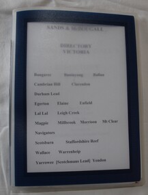
Document (item) - Information Folder, Sands and McDougall, Extracts from Sands and McDougall Directory of Victoria, 1939
... Towns include Buninyong, Bungaree, Ballan, Cambrian Hill Clarendon, Durham Hill, Egerton, Elaine, Enfield, Lal Lal, Leigh Creek, Magpie, Millbrook, Morrisons, Mount Clear, Navigators, Scotsburn, Staffordshire Reef, Wallace, Warrenheip, Yarrowee (Scotchman's Lead), Yendon....Towns include Buninyong, Bungaree, Ballan, Cambrian Hill Clarendon, Durham Hill, Egerton, Elaine, Enfield, Lal Lal, Leigh Creek, Magpie, Millbrook, Morrisons, Mount Clear, Navigators, Scotsburn, Staffordshire Reef, Wallace, Warrenheip, Yarrowee (Scotchman's Lead), Yendon. Directories Sands & McDougall Buninyong Occupations Individuals' names handwritten on the pages. ...Entries of resident's names and occupations in towns around the Shire of Buninyong. Towns include Buninyong, Bungaree, Ballan, Cambrian Hill Clarendon, Durham Hill, Egerton, Elaine, Enfield, Lal Lal, Leigh Creek, Magpie, Millbrook, Morrisons, Mount Clear, Navigators, Scotsburn, Staffordshire Reef, Wallace, Warrenheip, Yarrowee (Scotchman's Lead), Yendon.Individuals' names handwritten on the pages.directories, sands & mcdougall, buninyong, occupations -
 Federation University Historical Collection
Plan, Department of Crown Lands and Survey, Melbourne, Buninyong County of Grant, 23/07/1929
... warrenheip...Yarowee...Enfield...Thomas Learmonth...John Learmonth...Archibald Fisken...G. Schloo...George Innes...Peter Inglis...Durham Lead...Barker Library (top floor) Mount Helen goldfields The plan was photo-lithographed at the Departmen tof Lands and Survey, Melbourne Buninyong Scotchman's Mt Buninyong Robert Scott Clarendon Lal Lal Creek yendon warrenheip Yarowee Enfield Thomas Learmonth John Learmonth Archibald Fisken G. Schloo George Innes Peter Inglis Durham Lead J. ...The plan was photo-lithographed at the Departmen tof Lands and Survey, MelbourneA parish plan of Buninyong, including Robert Scott's Mt Buninyong Pre-emptive Right, Mt Buninyong Public Park, Thomas Learmonth's land, John Learmonth's land, Scotchan's, Yendon. The Buninyong POst Office is Allotment 1. Pisition of tracks in 1859 have been marked on the plan in red.buninyong, scotchman's, mt buninyong, robert scott, clarendon, lal lal creek, yendon, warrenheip, yarowee, enfield, thomas learmonth, john learmonth, archibald fisken, g. schloo, george innes, peter inglis, durham lead, j. fry, j. forrest, parkin lee, buninyong recreation reserve -
 Federation University Historical Collection
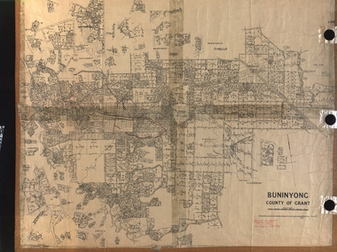
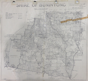
Map, Shire of Buninyong, c1970
... warrenheip...scotsburn...mt doran...durham lead...Includes Buninyong, Clarendon, Narmbool, Enfield, Lychfield, SCotchman's, Navigators, Warrenheip, Scotsburn, mr Doran, Durham Lead, Cambrian Hill, Napoleons, Garibaldi, Mt Clear, Lal Lal, Bonshaw...Includes Buninyong, Clarendon, Narmbool, Enfield, Lychfield, SCotchman's, Navigators, Warrenheip, Scotsburn, mr Doran, Durham Lead, Cambrian Hill, Napoleons, Garibaldi, Mt Clear, Lal Lal, Bonshaw Shire of Buninyong, c1970 Map Map J.J. ...The Shire of Buninyong was located on the southern side of Ballarat.Two maps of the Shire of Buninyong. .1) Map showing the County divisions, township boundaries, Railway line, State Forest boundary, riding boundary and shire boundary. Identifying words have been added in red and green texta. .2) Shire of Buninyong Parish Plan. Includes Buninyong, Clarendon, Narmbool, Enfield, Lychfield, SCotchman's, Navigators, Warrenheip, Scotsburn, mr Doran, Durham Lead, Cambrian Hill, Napoleons, Garibaldi, Mt Clear, Lal Lal, Bonshaw.1) B.I.A.E., St Martin's, cemetery, mt Buninyong, mt Innes, rly stn shire of buninyong, buninyong, clarendon, narmbool, enfield, lychfield, scotchman's, navigators, warrenheip, scotsburn, mt doran, durham lead, cambrian hill, napoleons, garibaldi, mt clear, lal lal, bonshaw, state forest, elaine, elaine north, cargerie, grenville, mt mercer, millbrook, wallace, yendon, canadian, kaolin deposits, mount helen campus -
 Federation University Historical Collection
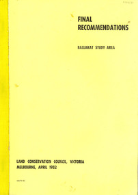
Book, Final recommendations Ballarat Study Area Land Conservation Council, Victoria, 1982, 1982
... warrenheip...nerrina...jubilee...golden stream...australasian deep lead...Barker Library (top floor) Mount Helen goldfields land conservation authority ballarat endowment plantations pine plantations langi ghiran state park mount buangor state park enfield state park ballarat-creswick regional park rossbridge black lake flax mill swamp dereel lagoon lake bolac lake wongan langi ghiran reservoir gong gong reservoir pincotts reservoir beales reservoir wilsons reservoir moorabool reservoir korweinguboora korweinguborra reservoir learmonth bores sago hill illabarook reservoir ballarat water commission dunneworthy mount cole mont lonarch ben major waterloo trawalla linton ross creek canadian shepherds flat lal lal mount doran raglan chute carngham buninyong watsons hill enfield cape clear illabrook rokewood junction mount warrenheip nerrina jubilee golden stream australasian deep lead mine happy valley school piggoreet berringa bulldog ballarat common wildlife water timber flora rivers geology agriculture warrenheip biodiversity Yellow soft covered report of 95 pages . ...Yellow soft covered report of 95 pages . The contents of the report include: Parks, reference areas, wildlife reserves, water production, hardwood production, softwood production, flora Reserves and Flora and Fauna reserves, bushland reserves, historic area and reserves, rivers and streams, Roadside conservation and Highway parks, Education areas and School Plantations, Lake Reserves, geological reserves, recreation, scenic reserves, agriculture, mineral and stone production, utilities and survey, township land, Uncommitted Land, military training, other reserves and public land. Maps include: The Study area 1: 250 000 Supplementary Mapsland conservation authority, ballarat, endowment plantations, pine plantations, langi ghiran state park, mount buangor state park, enfield state park, ballarat-creswick regional park, rossbridge, black lake, flax mill swamp, dereel lagoon, lake bolac, lake wongan, langi ghiran reservoir, gong gong reservoir, pincotts reservoir, beales reservoir, wilsons reservoir, moorabool reservoir, korweinguboora, korweinguborra reservoir, learmonth bores, sago hill, illabarook reservoir, ballarat water commission, dunneworthy, mount cole, mont lonarch, ben major, waterloo, trawalla, linton, ross creek, canadian, shepherds flat, lal lal, mount doran, raglan, chute, carngham, buninyong, watsons hill, enfield, cape clear, illabrook, rokewood junction, mount warrenheip, nerrina, jubilee, golden stream, australasian deep lead mine, happy valley school, piggoreet, berringa, bulldog, ballarat common, wildlife, water, timber, flora, rivers, geology, agriculture, warrenheip, biodiversity -
 Buninyong & District Historical Society
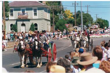
Photograph - Colour photograph, Buninyong and District Historical Society leads the 1991 Gold King Festival, 1991
... Colour photograph of the 1991 Gold King Festival with Bill Griggs of Wallace and his Clydesdales in the lead representing Buninyong and District Historical Society. View of the parade and spectators from Warrenheip Street, Old National Bank and roundabout in the background....Colour photograph of the 1991 Gold King Festival with Bill Griggs of Wallace and his Clydesdales in the lead representing Buninyong and District Historical Society. View of the parade and spectators from Warrenheip Street, Old National Bank and roundabout in the background. ...The Gold King Festival was an important community event for Buninyong incorporating historical, sporting, social and commercial activities for a number of years between 1991 and the early 2000sThe Gold King Festival was a popular community event celebrating Buninyong's gold mining history.Colour photograph of the 1991 Gold King Festival with Bill Griggs of Wallace and his Clydesdales in the lead representing Buninyong and District Historical Society. View of the parade and spectators from Warrenheip Street, Old National Bank and roundabout in the background.Buninyong and District Historical Society leads the 1991 Festival. Bill Grigg of Wallace with his Clydesdales.buninyong and district historical society, gold king festival, procession, events, celebrations -
 Buninyong & District Historical Society
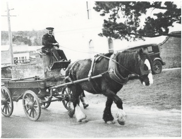
Photograph - Photo of Original Photograph, Merryweather Fire Engine, Warrenheip Street, 1930's
... Durham Lead Merryweather Fire Engine, Warrenheip Street, 1930's Photograph Photo of Original Photograph ...Merryweather manual fire engine, acquired by Buninyong Fire Brigade in 1882, in the last years of its working life. Engine now restored and homed in Buninyong Fire Station.Coloured photograph (and b/w print) of detail, interior of Boiler House, Whykes & Sons' Slaughter House and yards, showing railing and washing area for carcasses, functioned for Whykes Butchers from 1863-1994, situated at Slaughterhouse Rd. Durham Leadbuninyong, fire brigade, fire engine, merryweather, horse -
 Buninyong Visitor Information Centre
Document (item) - Information Folder, Durham Lead - State school
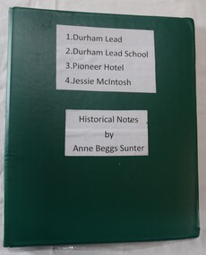
... Buninyong Visitor Information Centre 408 Warrenheip Street Buninyong goldfields Records the efforts of residents of Durham Lead to have a teacher reinstated at Durham Lead. ...Records the efforts of residents of Durham Lead to have a teacher reinstated at Durham Lead. Includes broader historical notes on the town by Anne Beggs Sunter.durham lead, education, state schools, teaching -
 Buninyong Visitor Information Centre
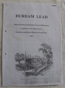
Document (item) - Information Folder, Anne Beggs-Sunter, Durham Lead - Historical Notes, 2008
... Buninyong Visitor Information Centre 408 Warrenheip Street Buninyong goldfields Folder includes handwritten talk on Durham Lead, by GJ Crombie, dated 1934. ...Folder includes handwritten talk on Durham Lead, by GJ Crombie, dated 1934.durham lead, post offices, state schools, education, schools -
 Buninyong Visitor Information Centre
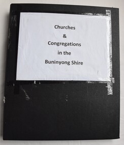
Document (item) - Information Folder, Buninyong Methodist Church, Churches and Congregations in the Buninyong Shire, 1955
... Warrenheip Street Buninyong goldfields Includes original centenary edition of Buninyong Methodist Church booklet and extensive notes on that church. The material gathered is not comprehensive for all churches in the district, past or present. Churches Religion Buninyong Methodism Uniting Church Presbyterian Church Black ring binder with plastic pockets containing notes on several churches in the Buninyong district. Notes included on Buninyong Methodist Church, Clarendon Presbyterian Church, Buninyong Uniting Church, Scotchman's Lead ...Includes original centenary edition of Buninyong Methodist Church booklet and extensive notes on that church. The material gathered is not comprehensive for all churches in the district, past or present.churches, religion, buninyong, methodism, uniting church, presbyterian church -
 Buninyong Visitor Information Centre
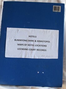
Document (item) - Information Folder, Buninyong Visitor Information Centre Volunteers, Hotels: Buninyong Shire and Sebastopol, 1990s
... Buninyong Visitor Information Centre 408 Warrenheip Street Buninyong goldfields Features hotels in Buninyong, Sebastopol, Durham Lead, Garibaldi. ...Features hotels in Buninyong, Sebastopol, Durham Lead, Garibaldi.hotels, publicans, licensees, buninyong, garibaldi -
 Buninyong Visitor Information Centre
Document (item) - Information Folder, Buninyong Visitor Information Centre Volunteers, Hotels: Buninyong Hire, Sebastopol and District, 1990s
... Buninyong Visitor Information Centre 408 Warrenheip Street Buninyong goldfields Towns mentioned in the lists include Scotchman's Lead, Elaine, Mount Clear, Clarendon, Sebastopol. ...Towns mentioned in the lists include Scotchman's Lead, Elaine, Mount Clear, Clarendon, Sebastopol.hotels, publicans, buninyong, sebastopol, elaine, clarendon, mount clear, scotchman's lead -
 Buninyong Visitor Information Centre
Document (item) - Information Folder, Stocks Family, Stocks Family History
... Buninyong Visitor Information Centre 408 Warrenheip Street Buninyong goldfields Includes extracts of material about the Durham Lead School. ...Includes extracts of material about the Durham Lead School.buninyong, family history, durham lead, schools, education, stocks family -
 Federation University Historical Collection
Map, Ballarat Goldfield, c1898
... warrenheip...lake wendouree...ballarat east...winters swamp...winter swamp...wyndholm premptive right...cemetery...vale park reserve...little bendigo...kneeshaw co....industrial school reserve...kirks dam...pincotts dam...black hill...wombat hill...dead horse gully...miners rest...mt rowan...salton and waldie...rose hill co...great north west no 1...rose's freehold co...hand and band co...police reserve...police paddock...mount rowan...ballarat industrial school reserve...market reserve...Winter's swamp...Kneeshar Co...Monte Cristo line of reef...Chinaman's Gully or Black Snake...Milkmaid's Gully...Ballarat gold field...Bakery Hil Lead...The map indicates the position of Lake Wendouree, Township of Warrenheip, Ballarat East, Industrial School Reserve, Winters Swamp, Police Paddock, Wyndholm Premptive Right (Salton and Waldie), Black Hill, Vale Park Reserve, Pennyweight Hill, Little Bendigo, Black Swamp Lead, monte Christo Reef, Chinaman's Gully, Miners Rest, Pincotts Dam, Northumberland Gully. ...The map indicates the position of Lake Wendouree, Township of Warrenheip, Ballarat East, Industrial School Reserve, Winters Swamp, Police Paddock, Wyndholm Premptive Right (Salton and Waldie), Black Hill, Vale Park Reserve, Pennyweight Hill, Little Bendigo, Black Swamp Lead, monte Christo Reef, Chinaman's Gully, Miners Rest, Pincotts Dam, Northumberland Gully. ...This map shows geological features, suggests the last basalt flow, and includes alotments and names of Mining Companies. Although this map has no date on it the Ballarat Industrial School is used for dating purposed. The Ballarat Industrial School ran from 1869-1879, but the term Ballarat Industrial School Reserve was still in use in 1898 and possibly beyond.Geological Map of Ballarat with 3 holes in the left hand side. The map indicates the position of Lake Wendouree, Township of Warrenheip, Ballarat East, Industrial School Reserve, Winters Swamp, Police Paddock, Wyndholm Premptive Right (Salton and Waldie), Black Hill, Vale Park Reserve, Pennyweight Hill, Little Bendigo, Black Swamp Lead, monte Christo Reef, Chinaman's Gully, Miners Rest, Pincotts Dam, Northumberland Gully. It also show the following goldmining companies: City of Ballarat, Kohinor, Hand and Band, Great North West, Northern Junction, Kneeshaw, Rossers Freehold, Silurial.ballarat, warrenheip, lake wendouree, ballarat east, winters swamp, winter swamp, wyndholm premptive right, cemetery, vale park reserve, little bendigo, kneeshaw co., industrial school reserve, kirks dam, pincotts dam, black hill, wombat hill, dead horse gully, miners rest, mt rowan, salton and waldie, rose hill co, great north west no 1, rose's freehold co, hand and band co, police reserve, police paddock, mount rowan, ballarat industrial school reserve, market reserve, winter's swamp, kneeshar co, monte cristo line of reef, chinaman's gully or black snake, milkmaid's gully, ballarat gold field, bakery hil lead, old gravel pits lead, golden point lead, eureka lead, miner's rest, yarrowee creek, leigh creek, black swamp lead, yorkshire reef, nil desperandum reef, cockatoo lead, hit or miss gully, herbert werner frederick de nully, pennyweight hill, esmond's lead, ash's lead, nightingale lead, john bull gully, gladstone reef, whitehorse reef, petticoat creek, pincott's dam, frenchman's gully, tim's crushing plant, jenkin's gully, california gully, drake's creek, sulton and waldie, ballarat undustrial school, ballarat & mariborough railway