Showing 18 items matching "west kiewa river"
-
 Falls Creek Historical Society
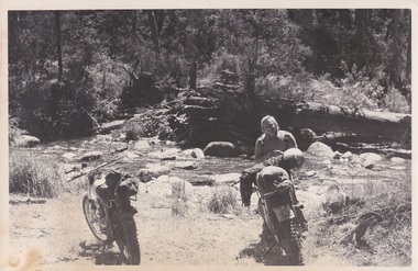
Photograph - George Shirling at the West Kiewa River
... George Shirling at the West Kiewa River...George Shirling at the West Kiewa River...A black and white image of George Shirling with two motorbikes on the bank of the West Kiewa River....George Shirling Koki Lodge A black and white image of George Shirling with two motorbikes on the bank of the West Kiewa River. George Shirling at the West Kiewa River Photograph George Shirling at the West Kiewa River ...George Shirling arrived in Falls Creek in 1962. He engaged Phil Nowell to build the original Koki Alpine Lodge which opened in 1965 with 14 beds. George operated the lodge with Michael “Baldy” Blackwell as manager. He also graduated in sport psychology in 1981 and was invited to become team psychologist for the Australian Winter Olympic team which went to Albertville, France, in 1992. He later owned the Red Onion Chalet. George credited the success of Koki to “Baldy” Blackwell. “Baldy” and Phil Nowell started the Trackers Mountain Lodge in partnership during the 1980s. In 1971 George sold Koki Lodge to Sigi Doerr. In 2024 the renamed Koki Alpine resort remains a highly popular destination in Falls Creek. George Shirling passed away on 27th February 2023. He had remained actively involved in Falls Creek and was generous with his time and knowledge, always an amazing supporter of The Falls Creek Museum and Falls Creek Village.This photo is significant because it captures an image of two pioneers of pioneers and active members of Falls Creek Village.A black and white image of George Shirling with two motorbikes on the bank of the West Kiewa River.george shirling, koki lodge -
 Kiewa Valley Historical Society
3 small black and white photos of West Kiewa River and Tail Race, c1948/49
... 3 small black and white photos of West Kiewa River and Tail Race...West Kiewa River; Tail Race portal; Mt Beauty; Kiewa Hydro Electric Scheme...Photo 1 - on back in ink - 'Tour of area, crossing West Kiewa Branch Jan. 1949 Photo 2 - on back in ink - 'Kiewa Valley River - site of tunnel in rear. ...Beauty Jan. 1949'. 3 small black and white photographs 3 small black and white photos of West Kiewa River and Tail Race ...The No. 4 Tail Race Tunnel was commenced in 1947 from the downstream end at Mt. Beauty. Difficulties were encountered and driving from the top end in a downstream direction was commenced in January 1950 and the breakthrough between these two headings occurred on 22d July.Historical record of the construction of the Kiewa Hydro Electric Scheme.3 small black and white photographsPhoto 1 - on back in ink - 'Tour of area, crossing West Kiewa Branch Jan. 1949 Photo 2 - on back in ink - 'Kiewa Valley River - site of tunnel in rear. Dec. 1948'. Photo 3 - on back in ink - 'No. 4 Tail Race Portal Mt. Beauty Jan. 1949'.west kiewa river; tail race portal; mt beauty; kiewa hydro electric scheme -
 Kiewa Valley Historical Society
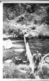
Black and white photograph of Surveyor's Camp, 1938, Kiewa River and surveyor's Camp 25/8/38, 25/08/1938
... ...west kiewa river...A black and white photograph showing a small, timber foot bridge across the West Kiewa River. There is a man standing on the bridge and two small huts on the far side of the river, against a backdrop of Mt. ...It is possibly one of the few photographs in existence of this camp and of the very rustic timber foot bridge across the West Kiewa river. It has been taken from approx. 100m up Simmonds Creek Road. surveyor tawonga west kiewa river bridge camp SECV At the top of the photograph, handwritten in black ink is the inscription "Kiewa River and Surveyor's Camp 25/8/38". ...Surveying under the prevailing conditions at this time was an arduous and demanding task. There were no roads beyond Tawonga and access was by bridle tracks, on foot or horseback. This camp was to provide accommodation to those men who were surveying the road from South Tawonga to the Bogong High Plains which was commenced in April, 1938. The actual work was undertaken by the Country Roads Board, on behalf of the State Electricity Commission, using three Caterpillar diesel crawler tractors equipped with Kay Bruneriei (Brunner) lhydraulically operated trailbuilders (angle dozers)This photograph shows the primitive living conditions that were endured by those carrying out the initial field investigations and surveys for the Kiewa Hydro Electric Scheme. It is possibly one of the few photographs in existence of this camp and of the very rustic timber foot bridge across the West Kiewa river. It has been taken from approx. 100m up Simmonds Creek Road. A black and white photograph showing a small, timber foot bridge across the West Kiewa River. There is a man standing on the bridge and two small huts on the far side of the river, against a backdrop of Mt. Beauty and Mt. Bogong.At the top of the photograph, handwritten in black ink is the inscription "Kiewa River and Surveyor's Camp 25/8/38". The number 4 is stamped towards the right upper corner. On the back, in a circle, about 1.3cm in diameter, are the words "Kodak Print". The word "Velox" is faintly discernible on the back as well.surveyor, tawonga, west kiewa river, bridge, camp, secv -
 Kiewa Valley Historical Society
Poster - Mt Beauty Gigantic Carnival, 1960
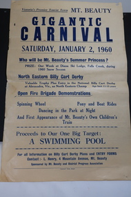
... The residents of Mt Beauty and the Kiewa Valley swam in the local East and West Kiewa Rivers. The community began planning the building of a swimming pool at Mt Beauty in the early 1960s and held events to raise money for it. ...Kiewa Valley Historical Society Mount Beauty Information Centre 31 Bogong High Plains Rd Mt Beauty high-country The residents of Mt Beauty and the Kiewa Valley swam in the local East and West Kiewa Rivers. The community began planning the building of a swimming pool at Mt Beauty in the early 1960s and held events to raise money for it. ...The residents of Mt Beauty and the Kiewa Valley swam in the local East and West Kiewa Rivers. The community began planning the building of a swimming pool at Mt Beauty in the early 1960s and held events to raise money for it. The building of a swimming pool in Mt Beauty is part of the construction town's development and demonstrates the support of the community, especially the Mt Beauty and District Progress Association, and the SECV.Yellowed paper with black print dated Saturday, January 2, 1960 advertising the events for the day at Mt Beauty. Proceeds to the Swimming Pool.mt beauty swimming pool, carnival, mt beauty and district progress association -
 Kiewa Valley Historical Society
Photos - SECV Gateway at Mt Beauty to the High Plains and x2 Mt Beauty Camp Extensions
... There were two gateways at Mt Beauty. One at the West Kiewa River closing off entry to Mt Beauty township and another leading to the High Plains from Mt Beauty. ...Kiewa Valley Historical Society Mount Beauty Information Centre 31 Bogong High Plains Rd Mt Beauty high-country There were two gateways at Mt Beauty. One at the West Kiewa River closing off entry to Mt Beauty township and another leading to the High Plains from Mt Beauty. ...There were two gateways at Mt Beauty. One at the West Kiewa River closing off entry to Mt Beauty township and another leading to the High Plains from Mt Beauty. These were put in by the SECV to control operations for the Kiewa Hydro Electric Scheme.Black and white photos - A. Gateway at Mt Beauty to the Bogong High Plains. B. a panorama photo of the Mt Beauty Camp Extensions 1950 taken in two shots thus spitting the middle photo.mt beauty gateway, mt beauty camp extensions -
 Kiewa Valley Historical Society
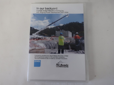
DVD - AGL Bogong Power Development & 6 DVDs with students contributions, In Our Backyard
... The request re the SECV Adit Shaft was to assist with the information board beside the shaft on the Gorges Walk on the West Kiewa River. DVDs were a digital means of passing on information to an audience and enabled multiple copies to be made. ...The request re the SECV Adit Shaft was to assist with the information board beside the shaft on the Gorges Walk on the West Kiewa River. DVDs were a digital means of passing on information to an audience and enabled multiple copies to be made. ...Students from Mt Beauty Secondary College produced this set of 3 DVDs re the development of AGL's Bogong Power Development 2007-2009. This was an addition to the Kiewa Hydro Electric Scheme built by the SECV in the 1950s. The information covers many aspects of the Development which is of interest as well as being educational for the students. The request re the SECV Adit Shaft was to assist with the information board beside the shaft on the Gorges Walk on the West Kiewa River. DVDs were a digital means of passing on information to an audience and enabled multiple copies to be made. The Kiewa Hydro Electric Scheme is in the Kiewa Valley producing clean energy for Victoria. The Bogong Power Development increased the production of electricity in line with more clean energy and gave locals employment and students an insight into its construction and issues. The technical aspect of using DVDs to present this knowledge was also part of the education for the local students. x3 DVDs with hard clear plastic box cover. The cover has a photo on the front with the title typed above it and production details below along with the AGL logo and its Mt Beauty logo.On the back the details (title and content) for each of the 3 DVDs is given. DVD Stories: 1, 2, 4, 7 & 8 and DVD "AGL Photos West Kiewa - In response to letter re photos of Adit Shaft. July 2013"bogong power development project, mt beauty secondary college 2007-2009, agl -
 Kiewa Valley Historical Society
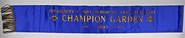
Sash, Mount Beauty Garden Sash
... 1947 The SEC created an Arboretum and Nursery on the bank of the West Kiewa River. Householder could collect free plants, trees and topsoil for their gardens. ...Kiewa Valley Historical Society Mount Beauty Information Centre 31 Bogong High Plains Rd Mt Beauty high-country 1947 The SEC created an Arboretum and Nursery on the bank of the West Kiewa River. Householder could collect free plants, trees and topsoil for their gardens. ...1947 The SEC created an Arboretum and Nursery on the bank of the West Kiewa River. Householder could collect free plants, trees and topsoil for their gardens. It was not long before there was very keen competition amongst the families to create the best garden. 1948 A Mount Beauty Garden competition started with a first prize of 15 pounds, second 7 pounds and third 3 pounds. As the oldest garden in the competition was only 25 months old and most were younger a handicap system of 4 points per month was devised. Tom Mitchell MLA was the donor and judge. 1965 This sash was possibility worn by Jean McCullough in 1965 when the Mt Beauty & District Progress Association Auxiliary ran the completion.An example of the social life at Mt Beauty during the construction of the Kiewa Hydro Electric Scheme.Royal blue sateen sash with gold fringe. Mt. BEAUTY & DIST. PROGRESS ASSN. AUXILIARY/CHAMPION GARDEN/1965textiles, arboretum, mount beauty, garden competition, kiewa hydro electric scheme -
 Kiewa Valley Historical Society
Papers - Hollonds' Family and their memories, 2013
... Kiewa Valley at Mulagong. Their descendants owned land in Tawonga, Tawonga South and between the East and West of the Kiewa river. ...Kiewa Valley at Mulagong. Their descendants owned land in Tawonga, Tawonga South and between the East and West of the Kiewa river. ...The Hollonds' family were original settlers in the Kiewa Valley at Mulagong. Their descendants owned land in Tawonga, Tawonga South and between the East and West of the Kiewa river. Hollonds had a cattle run on Mt Fainter which was later given to the Hicks family.Members of the Hollonds family lived, worked and married in the Kiewa Valley. These papers describe the connection to the families and the Kiewa Valley.Typed papers donated by the Hollonds' family covering: The Hollonds Family History, Cattlemen, 'Snowy' Miller, Mrs Hollonds' Boarding house, SEC Depot at Tawonga, building of Bogong Township, Early Scenes on the Kiewa Scheme.hollonds family, tawonga station, cattlemen, mt beauty land, tawonga boarding house -
 Kiewa Valley Historical Society
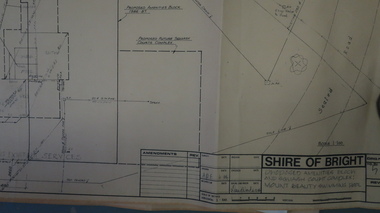
Plans - Mt Beauty Swimming Pool & Amenities Building, Mt Beauty Swimming Pool & Amenities Building by Shire of Bright
... Previously the community swam in the West and East Kiewa Rivers. The pool enabled all of the community to swim in a safe area and the opportunity to swim long distances....Kiewa Valley Historical Society Mount Beauty Information Centre 31 Bogong High Plains Rd Mt Beauty high-country Mt Beauty's Swimming Pool was built by Alpine Shire and included a Squash Court. October 1986. Previously the community swam in the West and East Kiewa Rivers ...Mt Beauty's Swimming Pool was built by Alpine Shire and included a Squash Court. October 1986. Previously the community swam in the West and East Kiewa Rivers. The pool enabled all of the community to swim in a safe area and the opportunity to swim long distances.History of swimming for the Kiewa Valley community and its affect on the following - social, education, and tourism6 large pages of black print on yellowed paper. Dated October 1986 and includes plans for the Mt Beauty Swimming Pool and a Squash Court.On back of the 6th plan in red pen "Roger Sorry Delay / Getting Plans Back / Norm Boden"mt beauty, swimming pool, squash court, shire of bright -
 Kiewa Valley Historical Society
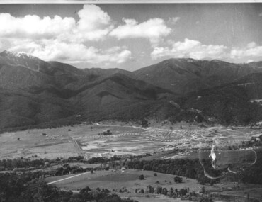
Photograph - Mt Beauty Camp, Estimated 1950-1951
... Beauty surrounded by farmland and before the regulating pondage was built to discharge water from the power stations via the West Kiewa tail race tunnel into the Kiewa River. Mt beauty camp SECV construction town Written on the back in black ink - A Campen Copy of black and white photograph of Mt Beauty Camp Photograph - Mt Beauty Camp ...This photo is of the very newly constructed State Electricity Commission town of Mt. Beauty. The houses up to Nelse street were erected from 1946 onward and then the township was extended beyond Nelse Street in 1950 which places this photograph about 1950/51. There is no evidence of work being commenced on the regulating pondage but the tail race canal can be seen on the centre right of photo. The workmen's camp was enlarged in 1950 to the extent of providing accommodation for a total of 1,200. There are a number of dwellings on Simmonds Creek and the road to Falls Creek can clearly be seen. Snow capped Mt. Bogong is in the upper left of the photo with Mt. Beauty behind the township rising to Big Hill beyond that.Shows the newly constructed town of Mt. Beauty surrounded by farmland and before the regulating pondage was built to discharge water from the power stations via the West Kiewa tail race tunnel into the Kiewa River. Copy of black and white photograph of Mt Beauty CampWritten on the back in black ink - A Campenmt beauty camp, secv, construction town -
 Kiewa Valley Historical Society
Photograph - Folder of Photographs – Photocopied set of black and white photographs (pages 49 -58) from the display folder put together by KVHS to document life on the Kiewa Valley Hydro-electric Scheme
... Kiewa River. These new ‘towns’ such as Mt Beauty and Bogong, survived, serving the needs of operational personnel and their families, and expanding with growth of new industries. Mount Beauty, and to a lesser extent Bogong, are among these places. secv; kiewa hydro electric scheme; bogong; mt beauty; construction area 1-SECV number at bottom of picture Half obscured possibly K8461 Page number 53 2-In West Kiewa Tunnel Page number 54 3- Construction of Junction Dam wall – approximately 1941 Page number 55 4&5- Residents of Kiewa House at Bogong ready to go to the ball at Mt Beauty-1946. ...Although the Kiewa Hydro-Electric Scheme was first proposed in 1911, construction did not commence until 1938. As part of the push to cut electricity costs and diversify supply, the Victorian Government (circa 1930) initiated the conversion from primarily brown coal supply to hydro – electricity. Field investigations during the 1940’s resulted in a new proposal for a scheme that had more than double the capacity of the 1938 scheme. The Kiewa Hydroelectric Scheme became the largest scheme of its kind in the State Of Victoria and the second largest scheme in Australia. The number of personnel involved in the planning and construction of the scheme increased dramatically. During the late 1940’s, most activity centred around the construction of the West Kiewa Power Station, Rocky Valley Reservoir, McKay Creek Power Station and the Bogong Creek Aqueduct.A common thread across all the larger hydro scheme constructions was the need for workers, both qualified and unqualified who came from around the world seeking a new life for themselves and their families. New accommodation and facilities were required for the army of workers engaged in construction in often remote and wild areas. The SEC had a high demand for timber, and set up the first of a number of sawmills at Bogong Creek in 1939 and set up the first hardwood logging in the headwaters of the Kiewa River. These new ‘towns’ such as Mt Beauty and Bogong, survived, serving the needs of operational personnel and their families, and expanding with growth of new industries. Mount Beauty, and to a lesser extent Bogong, are among these places. Large A3 size spiral bound display folder containing photocopied black and white photographs of various aspects of the early days of the Kiewa Valley Hydro-electric scheme including equipment, various work sites and photographs of workers and their families. 1-Workmen working inside one of the tunnels. 2-Workman drilling in West Kiewa Tunnel 3-Junction Dam wall construction 4&5-2B&W photographs Kiewa House residents ready to go to a ball in Mt Beauty 6-Workmen warming up in front of a fire at No 1 bench 7-Workmen being hauled in at No 4 P.S Shaft 8-No 4 Power Station – Drilling 9-Workmen eating a hot meal in the tunnel. 10-2 photographs (a)Pretty Valley camp showing workman’s huts and construction materials & (b)Worker in Langford Gap Basalt Hill Tunnel face 11-Tunnel entrance (unlabelled) with rail tracks in foreground 12- Workmen drilling at No 1 Head race tunnel-Drilling face 13- No 1 Power Station 14-Workmen at the entrance to one of the SECV tunnels under construction 1-SECV number at bottom of picture Half obscured possibly K8461 Page number 53 2-In West Kiewa Tunnel Page number 54 3- Construction of Junction Dam wall – approximately 1941 Page number 55 4&5- Residents of Kiewa House at Bogong ready to go to the ball at Mt Beauty-1946. Handwritten on a copy of the photo on opposite page Mrs Lorna Crosset filled out the names *Dad was Des Crossett – his daughter is Gael Petcopoulis Greta engaged to John broke it off. Charlie, Rosalind, Bill, Priscilla, Max Lawrence-Dad’s Boss, Mary & Max married, Mary, Kay, Gwen McPherson Mum’s boss, John McCluskey (c) At No. 5 Bench Page number 56 6- STATE ELECTRICITY COMMISSION OF VICTORIA Date: 27.2.51 Time:2.15pm No K6373 Kiewa Hydro Electric Works No. 4 P.S. Shaft – Haulage of men in buckets (b) As above Handwritten at top of photo Appendix 4 page number 57 7- STATE ELECTRICITY COMMISSION OF VICTORIA Date: 6.6.52 Time:… No K7122 Kiewa Hydro Electric Works No. 4 POWER STATION – DRILLING page number 58 8-No markings page number 59 9-(a)Handwritten under photograph Approx. 1948/49 (b) STATE ELECTRICITY COMMISSION OF VICTORIA Date: 28.10.54 Time:.. No K7860 Kiewa Hydro Electric Works LANGFORD GAP BASALT HILL TUNNEL FACE Page number 49 10-(a) No markings 11- STATE ELECTRICITY COMMISSION OF VICTORIA Date: 20.3.52 Time: No K6979 Kiewa Hydro Electric Works No. 1 HEAD RACE TUNNEL – DRILLING FACE (E.E.E. CONTRACT) ‘The Frenchies’ (E.E.E) as they were affectionately known Page number 50 12-31.5.56 No. 1 Power Station Aggregate Stock Piles. Page number 51 13&14-No markings Page number 52 secv; kiewa hydro electric scheme; bogong; mt beauty; construction area -
 Kiewa Valley Historical Society
Map - Bogong High Plains - Grazing Runs, Grazing Run Boundaries 1960 - Soil Conservation Authority
... Bogong High Plains from Feathertop in the west to Mt Nelse in the east showing physical boundaries including the Kiewa Hydro Electric Scheme, roads, rivers and mountains. ...kiewa valley families White paper with brown print. Bogong High Plains from Feathertop in the west to Mt Nelse in the east showing physical boundaries including the Kiewa Hydro Electric Scheme, roads, rivers and mountains. ...Cattle grazing on the Bogong High Plains during summer commenced in the 1840s and continued for many years. The Soil Conservation Authority recorded each family's area boundaries which were updated in June 1972 and continued to be adjusted until cattle were banned in 2005. The tradition of cattle grazing continues to be controversial.Holders of grazing rights for grazing on the Bogong High Plains were allocated specific areas recorded by the Soil Conservation Authority in 1972. Cattle have been banned in the Alpine National Park due to their impact on the environment.White paper with brown print. Bogong High Plains from Feathertop in the west to Mt Nelse in the east showing physical boundaries including the Kiewa Hydro Electric Scheme, roads, rivers and mountains. Names of families with grazing runs and the boundaries are shown.cattlemen, grazing runs, bogong high plains, kiewa valley families -
 Kiewa Valley Historical Society
Folder - Family History, The Maddison Family, 1968 and later
... George Maddison selected land in 1877 between the East and West Kiewa branches of the Kiewa River - known as the "Island". ...Kiewa Valley Historical Society Mount Beauty Information Centre 31 Bogong High Plains Rd Mt Beauty high-country George Maddison selected land in 1877 between the East and West Kiewa branches of the Kiewa River - known as the "Island". ...George Maddison selected land in 1877 between the East and West Kiewa branches of the Kiewa River - known as the "Island". Now Mt Beauty.Pioneer family in the Kiewa ValleyPlastic brown folder with transparent front held by 2 gold metal slide clips. 9 clear plastic sheets holding 4 typed sheets, 3 typed sheets by Ted Maddison 1968, 4 handwritten pages in 1 plastic sleeve and 6 handwritten pages in 1 plastic sleeve (the handwritten sheets are the same as the typed sheets.)maddison family; mount beauty; kiewa valley -
 Kiewa Valley Historical Society
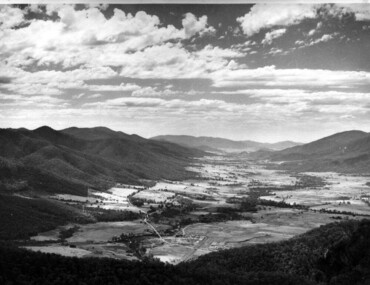
Photograph of Kiewa Valley Panorama, Kiewa Valley from No. 5 Road, Before 1945
... West Kiewa Power Station and Big Hill Scenic Lookout. Is an excellent view of the Kiewa Valley before there was little work undertaken to establish the town of Mt. Beauty. Farming was well established with the evidence of huge areas of cleared land. The junction of the East and West Kiewa Rivers ...In 1943 a camp for workmen was erected and a commencement made with the erection of plant storage and workshop buildings in the new township of Mt. Beauty. The photograph was probably taken after the completion of these buildings. There is no sign of construction of the town itself. In the latter part of 1945 work was commenced on the Mt. Beauty township area with a medical centre, general trading store and some houses under construction. The No. 5 Road, from where the photograph was taken, is the road to West Kiewa Power Station and Big Hill Scenic Lookout.Is an excellent view of the Kiewa Valley before there was little work undertaken to establish the town of Mt. Beauty. Farming was well established with the evidence of huge areas of cleared land. The junction of the East and West Kiewa Rivers can be clearly seen. The first Workmen's camp is near the river and some workshop buildings can also be seen. Black and white photograph of the Kiewa Valley, looking North.Handwritten on the back of photograph "Kiewa Valley from No. 5 Road".kiewa valley, camp, buildings, mt. beauty -
 Kiewa Valley Historical Society
Photograph of Mt. Beauty, Mt. Beauty from transmission line, Approx 1950/51
... Beauty surrounded by farmland and before the regulating pondage was built to discharge water from the power stations via the West Kiewa tail race tunnel into the Kiewa River. mt. beauty construction pondage state electricity commission Hand written on back of photograph "Mt. ...This photo is of the very newly constructed State Electricity Commission town of Mt. Beauty. The houses up to Nelse street were erected from 1946 onward and then the township was extended beyond Nelse Street in 1950 which places this photograph about 1950/51. There is no evidence of work being commenced on the regulating pondage but the tail race canal can be seen on the centre right of photo. The workmen's camp was enlarged in 1950 to the extent of providing accommodation for a total of 1,200. There are a number of dwellings on Simmonds Creek and the road to Falls Creek can clearly be seen. Snow capped Mt. Bogong is in the upper left of the photo with Mt. Beauty behind the township rising to Big Hill beyond that.Shows the newly constructed town of Mt. Beauty surrounded by farmland and before the regulating pondage was built to discharge water from the power stations via the West Kiewa tail race tunnel into the Kiewa River. Black and white photographHand written on back of photograph "Mt. Beauty from Transmission Line"mt. beauty, construction, pondage, state electricity commission -
 Kiewa Valley Historical Society
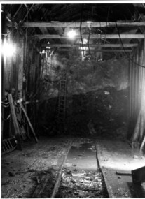
Photograph Tailrace tunnel Arch Drive, Tunnel face at Tailrace showing Arch Drive, between 1943 and 1952
... West Kiewa Power Station and Mt. Beauty. Much of the area was unstable and timber supports were erected prior to concreting. The tunnel was commenced in 1941 and completed in 1952. It brings water from the power station into the open tailrace at Mt. Beauty and then into the regulating pondage before discharge into the Kiewa River...West Kiewa Power Station and Mt. Beauty. Much of the area was unstable and timber supports were erected prior to concreting. The tunnel was commenced in 1941 and completed in 1952. It brings water from the power station into the open tailrace at Mt. Beauty and then into the regulating pondage before discharge into the Kiewa River ...This photo was taking during construction of the tailrace tunnel between West Kiewa Power Station and Mt. Beauty. Much of the area was unstable and timber supports were erected prior to concreting. The tunnel was commenced in 1941 and completed in 1952. It brings water from the power station into the open tailrace at Mt. Beauty and then into the regulating pondage before discharge into the Kiewa River.Shows method of construction for supporting walls and ceiling of tunnel with timber, size of tunnel (note worker on upper level), and conditions in the work place during construction in the 1940's/50's - note the timber ladder to gain access to the upper level.Black and white photographHand written on back of photograph "Tunnel face at Tailrace showing Arch Drive".tailrace, power station, water, construction -
 Kiewa Valley Historical Society
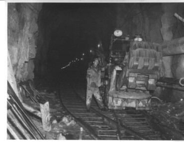
Photograph of Rail Mounted Battery operated soil Bucket, between 1941 and 1946
... This particular photograph was taken in the Tailrace Tunnel which brings water from West Kiewa Power Station to the open tailrace in Mt. Beauty and then into the regulating pondage before discharge into the Kiewa River. ...This particular photograph was taken in the Tailrace Tunnel which brings water from West Kiewa Power Station to the open tailrace in Mt. Beauty and then into the regulating pondage before discharge into the Kiewa River. ...This machine was in use in the 1940's during the construction of the tunnels for the Hydro Electric scheme. This particular photograph was taken in the Tailrace Tunnel which brings water from West Kiewa Power Station to the open tailrace in Mt. Beauty and then into the regulating pondage before discharge into the Kiewa River. This machine (or one similar) is on display on the Northern side of the entrance to the Visitor's Centre. The tailrace tunnel (or West Kiewa tunnel) was commenced in 1947 from both ends and the breakthrough occurred on 22nd. July, 1950Shows the size of the tunnel and the machinery used for excavation in the 1940's/50's.Black and white photographHandwritten on back of photograph "Jumbo" in Tailrace Tunneltunnel, machinery, water, tail race -
 Falls Creek Historical Society
Photograph - Jack Maddison Leading horses on the Bogong High Plain
... In 1877 Jack’s grandfather George Maddison selected land between the East and West Kiewa branches of the Kiewa River - known as the "Island". ...In 1877 Jack’s grandfather George Maddison selected land between the East and West Kiewa branches of the Kiewa River - known as the "Island". ...The images in the Bogong Village Collection were displayed in Bogong Jack’s Tavern for over 20 years and were donated to the Falls Creek Museum when the Tavern closed in 2021. In 1939, the State Electricity Commission of Victoria established a field headquarters at Bogong to house workers and their families for the Kiewa Hydroelectric Scheme which ran from the 1930s to the 1960s. The workmen's camp was originally started with tents and was called Junction Camp. By 1947, the village supported 300 workers and their families. It included 40 houses, a hostel for single staff, a post office, a police station, a medical centre, and a primary school. The staff hostel was known as Kiewa House. At the completion of the Scheme, in the 1960s, the village was opened to public/tourism use. In 1968 the Victorian Education Department acquired the camp buildings and four houses from the State Electricity Commission of Victoria to establish an Outdoor Education Centre which operated for over 50 years. The Kiewa Hydroelectric Scheme was privatized in the 1990s and sold to Southern Hydro, before being acquired by AGL in 2005. In 2023 the Grollo Group signed a 73 year sublease on Bogong Village and has plans for its redevelopment as a workers’ village. John Maddison and his wife Mary Padman emigrated from London to Australia in 1850 with their five sons. Jack (John James William Maddison) was one of their great grandsons. In 1877 Jack’s grandfather George Maddison selected land between the East and West Kiewa branches of the Kiewa River - known as the "Island". It is now known as Mount Beauty. The Maddison family built Aertex Hut at the top of T Spur at Mt. Bogong for use when grazing cattle. It later became known as Maddison's Hut. Staircase Spur walking track at Bogong was formerly known as Maddison’s Track as it is the path once used by the Maddison family to drive their cattle on to the high plains. These images are significant because they feature the son of a pioneering family on the Bogong High Plains.A black and white photograph of Jack Maddison leading horses on the Bogong High Plains.bogong alpine village, bogong high plains, maddison family mt beauty, maddison's hut, aertex hut,