Showing 200 items matching "workers camp"
-
 Lorne Historical Society
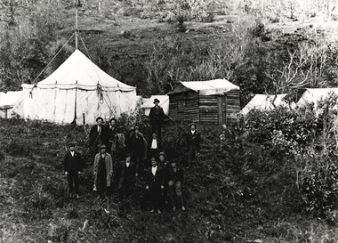
Photograph, Great Ocean Road Workers Camp at Big Hill
... Great Ocean Road Workers Camp at Big Hill......Workers Camp...Great Ocean Road Workers Camp at Big Hill in 1920. Overseer B. ...Lorne Historical Society Lorne Community House Mountjoy Parade Lorne great-ocean-road Big Hill; Great Ocean Road; Workers Camp Great Ocean Road Workers Camp at Big Hill in 1920. ...Great Ocean Road Workers Camp at Big Hill in 1920. Overseer B. Bridges. Photo of 13 men outside campsitebig hill; great ocean road;, workers camp -
 Kiewa Valley Historical Society
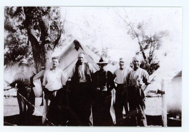
Photograph of Pretty Valley Workers Camp*, Pretty Valley Camp, circa 1949
... Photograph of Pretty Valley Workers Camp*...Erection of staff quarters at Pretty Valley was completed in April, 1947 and accommodation for construction workers commenced in 1948 but suspended on 11th May for winter and resumed on 9th November. Construction of this camp was completed in 1949. ...Pretty Valley Camp Photograph of Pretty Valley Workers Camp* probably taken by Mr. R. Duncan ...Erection of staff quarters at Pretty Valley was completed in April, 1947 and accommodation for construction workers commenced in 1948 but suspended on 11th May for winter and resumed on 9th November. Construction of this camp was completed in 1949. A large dam was proposed at this site but was never constructed. Instead a small diversion dam was built which diverts water either to Rocky Valley Dam or to McKay Creek Power Station.An historical record of the type of accommodation provided for workmen during the construction of the Kiewa Hydro Scheme during the 1940's/50's.A black and white photograph of Pretty Valley Camp, c 1949. Dead trees are in the foreground, on both the left and right side of the photograph and a small snow gum is evident. There are camp huts and a much larger building behind these, possibly a workshop, and power poles are evident bringing electricity to the site.Handwritten in blue ink on back of photograph "Pretty Valley Camp. 5600 ft. above sea level".pretty valley, dam, water, workmen, camp -
 Orbost & District Historical Society
Photograph - workers camp, c. 1915
... workers camp...This is a printed copy and is not an original photo. Photograph workers camp ...The construction of the Bairnsdale to Orbost railway line 1912-1916 was a major event for East Gippsland and the Orbost district in particular. Hundreds of men worked on the project and at least 7 deaths are recorded. Men lived in railway camps along the construction route. The caption on this photo indicates that these men were part of the workforce for the large timber railway bridges at Newmerella, adjacent to Orbost. This photo is significant because it records 6 workers involved in a major project for the Orbost district in the early 20th century. It records the way of life of these men. A b/w photograph of a group of 6 men in outdoor working clothes in front of tents. Behind the tents are trees and a bushland setting. Two men are wearing hats. This is a printed copy and is not an original photo. On the back of the photo: Workers on railway bridge at Newmerella, Victoria.railways, orbost-bairnsdale railway line, workers -
 Slovenian Association Melbourne
Camp Latina, workers, photo, Camp Latina, workers, Pero - Istria, R Koloini, M Krsevan, F Savle, A Mrak
... Camp Latina, workers, photo...Camp Latina, workers, Pero - Istria, R Koloini, M Krsevan, F Savle, A Mrak...Slovenian Association Melbourne 82 Ingrams Road Research melbourne Camp Latina, workers, Pero - Istria, R Koloini, M Krsevan, F Savle, A Mrak Camp Latina, workers, photo ... -
 Lorne Historical Society
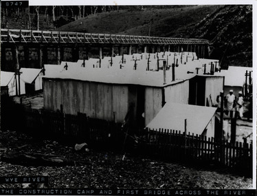
Photograph, Workers camp at Wye River Great Ocean Road
... Workers camp at Wye River Great Ocean Road...Denuded hillside and dead trees. Workers camp at Wye River Great Ocean Road Photograph Photograph ...Photograph showing wooden bridge across Wye River, with workmen's camp below. Shows galvanized iron sheds, cooks standing outside huts, tents. Denuded hillside and dead trees. -
 Lorne Historical Society
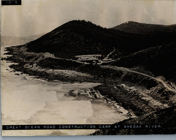
Photograph, Camp at She Oak River 1930's. G.O.R
... ...workers camp...Photograph of workers camp at She Oak River circa 1930's ...Lorne Historical Society Lorne Community House Mountjoy Parade Lorne great-ocean-road she oak river camp site: workers' campsite Sheoak River workers camp Photograph of workers camp at She Oak River circa 1930's Camp at She Oak River 1930's. ...Photograph of workers camp at She Oak River circa 1930's she oak river camp site: workers' campsite, sheoak river, workers camp -
 Ballarat Heritage Services
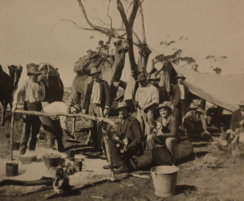
Photograph, Workers on the Transcontinental Railway, c1905
... Photograph of a workers camp on the Transcontinental Railway, which runs from Adelaide to Darwin....Ballarat Heritage Services PO Box 2209 Bakery Hill Post Office goldfields the ghan trans continental railway camp camel Photograph of a workers camp on the Transcontinental Railway, which runs from Adelaide to Darwin. ...Photograph of a workers camp on the Transcontinental Railway, which runs from Adelaide to Darwin.the ghan, trans continental railway, camp, camel -
 Slovenian Association Melbourne
Camp Latina, workers, photo, Camp Latina building site workers, F Savle, K Strancar, Florijan, M Krsevan, A Mrak, Pero, L Markic
... Camp Latina, workers, photo...Slovenian Association Melbourne 82 Ingrams Road Research melbourne Camp Latina building site workers, F Savle, K Strancar, Florijan, M Krsevan, A Mrak, Pero, L Markic Camp Latina, workers, photo ... -
 Eltham District Historical Society Inc
Photograph, Railway construction camp Eltham, 8/6/12
... Photograph of group of railway construction workers at construction camp Eltham 08/06/1912...Eltham District Historical Society Inc 728 Main Rd Eltham melbourne railways groups eltham Photograph of group of railway construction workers at construction camp Eltham 08/06/1912 Railway construction camp Eltham Photograph ...Photograph of group of railway construction workers at construction camp Eltham 08/06/1912railways, groups, eltham -
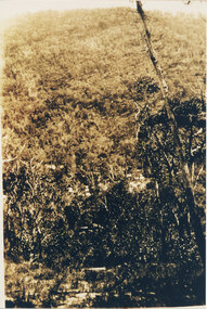 Halls Gap & Grampians Historical Society
Photograph, C 1920s
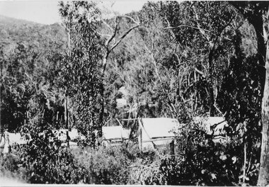
... Victory Road under construction. The workers camp can be seen in front of the road. ...Victory Road under construction. The workers camp can be seen in front of the road. ...This is a photo of the Mt. Victory Road under construction. The workers camp can be seen in front of the road. For further information see 'Victoria's Wonderland', pp 102, 112 & 136. Note: The second copy is a transparency held at Slide Box No. 162.The photo shows a slope covered in thick bush. A road can just be seen in the middle foreground and a campsite with many tents can be seen through the bush in front of the road.access routes, mt victory rd -
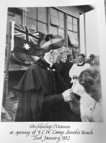 Phillip Island and District Historical Society Inc.
Photograph, Archbishop Mannix at YCW Camp, 2 January 1952
... YCW is the acronym of the Young Catholic Workers. The camp is just back from the dunes....Phillip Island and District Historical Society Inc. phillip-island-and-the-bass-coast YCW is the acronym of the Young Catholic Workers. The camp is just back from the dunes. archbishop mannix ycw camp smiths beach photographs Archbishop Mannix at opening of YCW Camp, Smith's Beach,. 2 January 1952 Large black & white photo mounted on cardboard of Archbishop Mannix, buiding, Australian flag and several people Archbishop Mannix at YCW Camp Photograph ...YCW is the acronym of the Young Catholic Workers. The camp is just back from the dunes.Large black & white photo mounted on cardboard of Archbishop Mannix, buiding, Australian flag and several peopleArchbishop Mannix at opening of YCW Camp, Smith's Beach,. 2 January 1952archbishop mannix, ycw camp, smiths beach, photographs -
 Kiewa Valley Historical Society
Map - Kiewa Scheme General Plan
... Mountains, rivers, roads and SECV places are named, also SECV infrastructure and construction eg. workers camps, Power stations....Mountains, rivers, roads and SECV places are named, also SECV infrastructure and construction eg. workers camps, Power stations. Significant for the information re the Kiewa Hydro Electric Scheme's development. bob duncan kiewa hydro electric scheme secv khes development Handwritten: 'Bob Duncan' Yellowed paper with brown print. ...Existing and possible future roads are numbered and named 1 - 45. The plan is based on an aerial photos taken March 1945. It includes revisions up to 1951. Signed by H.H.C. Williams, construction engineer. Mountains, rivers, roads and SECV places are named, also SECV infrastructure and construction eg. workers camps, Power stations.Significant for the information re the Kiewa Hydro Electric Scheme's development.Yellowed paper with brown print. Kiewa Scheme general plan showing its development. A lot of information is recorded. Note: Dyeline print was used which causes fading when exposed to light. Handwritten: 'Bob Duncan'bob duncan, kiewa hydro electric scheme, secv, khes development -
 Lakes Entrance Historical Society
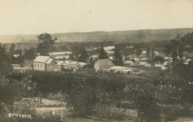
Postcard - Bruthen Victoria, 1914
... Letter on back written by Bruthen rail survey camp worker dated 28/ 6 /14...Lakes Entrance Historical Society 4 Marine Parade Lakes Entrance gippsland Letter on back written by Bruthen rail survey camp worker dated 28/ 6 /14 Township Transport Land Settlement Bruthen 1914 Sepia toned postcard of view of Bruthen showing R C Church on left Congregational Church centre and Church of England just beyond it, Tambo River in the distance Bruthen Victoria. ...Letter on back written by Bruthen rail survey camp worker dated 28/ 6 /14Sepia toned postcard of view of Bruthen showing R C Church on left Congregational Church centre and Church of England just beyond it, Tambo River in the distance Bruthen Victoria. Also a larger black and white copy plus details of letter on the back of original cardBruthen 1914township, transport, land settlement -
 Kiewa Valley Historical Society
16 Photos - A.N. Barnes Collection
... Aerial photo of Tawonga South; Aerial photo of Tawonga South Aerial view of upper Kiewa Valley Clover P{ower Station / No. 3 Power Station Bogong High Country with snow Bogong Village / Lake Guy Lake Guy dam wall spilling with Bogong Village in background The interior of Lake Guy dam wall Bogong Village at night with lights reflecting in Lake Guy Bogong dam wall overflowing Pretty Valley Camp BHP Road to Rocky Valley The workers' camp at Clover Flat Unknown Two unknown men with a vehicle at the top of the Bright Gap note distance and elevations on sign posts and Royal auto signs on arrows SEC Workmen's Camp ...Kiewa Hudro Electric Scheme A.N.Barnes Aerial photo of Tawonga South; Aerial photo of Tawonga South Aerial view of upper Kiewa Valley Clover P{ower Station / No. 3 Power Station Bogong High Country with snow Bogong Village / Lake Guy Lake Guy dam wall spilling with Bogong Village in background The interior of Lake Guy dam wall Bogong Village at night with lights reflecting in Lake Guy Bogong dam wall overflowing Pretty Valley Camp BHP Road to Rocky Valley The workers' camp at Clover Flat Unknown Two unknown men with a vehicle at the top of the Bright Gap note distance and elevations on sign posts and Royal auto signs on arrows SEC Workmen's Camp 16 Photos - A.N. ...The State Electricity Commission of Victoria constructed the Kiewa Hydro Electric Scheme which included the townships of Bogong and Mount Beauty - from the late 1940s until 1961 The KHES changed the Kiewa Valley from a rural community to a construction community.Aerial photo of Tawonga South; Aerial photo of Tawonga South Aerial view of upper Kiewa Valley Clover P{ower Station / No. 3 Power Station Bogong High Country with snow Bogong Village / Lake Guy Lake Guy dam wall spilling with Bogong Village in background The interior of Lake Guy dam wall Bogong Village at night with lights reflecting in Lake Guy Bogong dam wall overflowing Pretty Valley Camp BHP Road to Rocky Valley The workers' camp at Clover Flat Unknown Two unknown men with a vehicle at the top of the Bright Gap note distance and elevations on sign posts and Royal auto signs on arrows SEC Workmen's Camp kiewa hudro electric scheme, a.n.barnes -
 Halls Gap & Grampians Historical Society
Photograph - Sepia, C 1920s
... Photo is said to be that of roadmakers camp for workers on the construction of the Mt Victory Road...Halls Gap & Grampians Historical Society Centennial Hall 117-119 Grampians Road Halls Gap grampians Photo is said to be that of roadmakers camp for workers on the construction of the Mt Victory Road STRUCTURES Tents ACCESS ROUTES Road building Road makers camp Mt Victory Rd during the dat 1920s Photo shows a number of tents in bush land, said to be road makers camp Photograph Sepia ...Photo is said to be that of roadmakers camp for workers on the construction of the Mt Victory RoadPhoto shows a number of tents in bush land, said to be road makers campRoad makers camp Mt Victory Rd during the dat 1920sstructures, tents, access routes, road building -
Alexandra Timber Tramway & Museum
Mr Sapsford, rubicon .Near power house (tin hut)
... rubicon photo black and white of power house ,in forground chonnel running over the rubicon river , mens camp for workers in back ground . taken by Mr Sapsford of Alexandar . in good cond...Alexandra Timber Tramway & Museum 17 Station Street Alexandra high-country Power house was called the tin hut by those who built it and other locals . the building of Rubicon power house was helped by the timber indusary .As the timber and locals were helped by the building and supply of power Un replaceable rubicon . near power house (tin hut) rubicon photo black and white of power house ,in forground chonnel running over the rubicon river , mens camp for workers in back ground . taken by Mr Sapsford of Alexandar . in good cond rubicon .Near power house (tin hut) Mr Sapsford ...Power house was called the tin hut by those who built it and other locals . the building of Rubicon power house was helped by the timber indusary .As the timber and locals were helped by the building and supply of powerUn replaceablerubicon photo black and white of power house ,in forground chonnel running over the rubicon river , mens camp for workers in back ground . taken by Mr Sapsford of Alexandar . in good condrubicon . near power house (tin hut) -
 Kiewa Valley Historical Society
Set of 3 black and white photographs of Lake Guy, Bogong Village and single men's quarters, 1943/44
... As well, there was a hostel for staff personnel and prefabricated units, each 10 feet x 8 feet, with separate dining and recreational facilities for the worker's. This camp was closed in 1962....As well, there was a hostel for staff personnel and prefabricated units, each 10 feet x 8 feet, with separate dining and recreational facilities for the worker's. This camp was closed in 1962. These photos show the type of accommodation, available in this period, as well as the benched layout of the village. ...Construction of Bogong Village was commenced in 1940 and was the Field Headquarters for the early part of the construction of the Kiewa Hydro Electric Scheme. In all, a total of 36 houses, medical centre, police station, trading store and primary school were built. As well, there was a hostel for staff personnel and prefabricated units, each 10 feet x 8 feet, with separate dining and recreational facilities for the worker's. This camp was closed in 1962.These photos show the type of accommodation, available in this period, as well as the benched layout of the village. The damage of the 1939 bushfires is still evident.1. Black and white photo of Junction Dam Wall, Lake Guy and Bogong Village. 2.Black and white photo of single men's quarters at Bogong Village. 3.Lake Guy and Bogong Village.1.Back of photo, Left upper corner - K1334 Upper Right corner - mu (very faint) 6-10-43 2.Back of photo, Left upper corner - K1399 Upper right corner - 14 m 1-2-44 3. Back of photo, left upper corner -K1738 Upper right corner - 145 a mus 5-12-44 bogong village, lake guy, secv -
 Melton City Libraries
Photograph, Melton Railway Bridge, c.1884
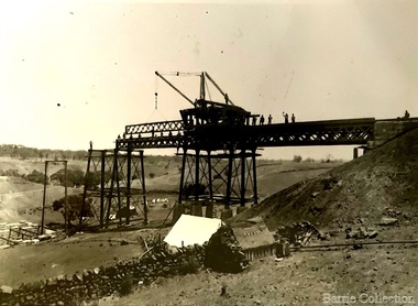
... Construction of the bridge, and the associated large workers camp, were extensively photographed, documenting an important episode in local history. ...Construction of the bridge, and the associated large workers camp, were extensively photographed, documenting an important episode in local history. ..."The Melton Viaduct, opened in 1886, is of State heritage significance as a very large and visually distinctive wrought iron, lattice girder trestle bridge over the Werribee River (now Melton Reservoir). It comprises 18.3 and 9.1 metre spans, in a generally alternate arrangement, of total length 375 metres, and standing 38 metres over the Werribee River. Wrought iron small section iron was used to build tension trussed trestle legs, which supported four lines of rivetted wrought-iron deck-type double lattice trusses. It has bluestone abutments and pier bases of coursed rock-faced bluestone with drafted margins. The larger half-piers, now usually submerged in the Melton Reservoir have sharp tapered cutwaters and curved coping at the tops. While designed to carry two rail tracks it has only ever been used as a single track line. Despite several alterations to its deck structure, it remains an outstanding example of a lighter structural design employing open metal trestle supports and metal truss girders. The direct Melbourne to Ballarat railway link of which the Melton viaduct was the major engineering work contributed significantly to the history and development of Victoria. This new link reflected Ballarat’s diversifying economy as well as the commercial and political influence of the metropolis. Construction of the bridge, and the associated large workers camp, were extensively photographed, documenting an important episode in local history. The railway enabled the development of new industries in the Melton area, notably the timber industry and a chaff industry of national importance, greatly facilitated the later transition of the Shire from a pastoral to a farming economy, and struck a major blow to Melton township’s era as a wayside town servicing Ballarat road (especially coach) traffic". Melton Railway Bridge being built across the Werribee Rivertransport -
 Ringwood and District Historical Society
Document - Folder, Brief history of the Ringwood Secondary College site in Bedford Road, Ringwood, Victoria, since 1905 and subdivision in 1924
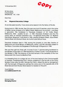
... It Is Interesting that at no stage did any of the land belong to the Commonwealth of Australia, notwithstanding that I always understood It was the site of the P.M.G. Workers Camp after the War. Perhaps the P.M.G. utilized the site by arrangement with the borough of Ringwood; perhaps the camp was on the opposite site of Hill Street (Government Road). ...It Is Interesting that at no stage did any of the land belong to the Commonwealth of Australia, notwithstanding that I always understood It was the site of the P.M.G. Workers Camp after the War. Perhaps the P.M.G. utilized the site by arrangement with the borough of Ringwood; perhaps the camp was on the opposite site of Hill Street (Government Road). ...Terry Kane and Richard Carter were the authors of the short historyType written notes and plans pertaining to the land titles and history of the Ringwood Secondary College site from 1905, prior to the land being sold by the Borough of Ringwood in 1954 to the Education Department. Transcript of covering letter from Richard Carter to Mr T Kane dated 16 November 2012 - "Re: Ringwood Secondary College As we discussed recently, I have done some research into the history of the site. Going back to 1905, the site, then 26 acres one rood 37 perches, was in the name of Walter James Anderson of 61 William Street, Melbourne, Accountant - most likely a speculator. Title transferred to Theodosia Anderson of 167 Collins Street, Melbourne, Artist - possibly his son - In 1907. Theodosia Anderson was thus the owner when on abortive subdivision Into "110 Splendid Home Sites" as "Bedford Park Estate, Ringwood" took place In 1924, creating Anderson Street, Joyce Street, Adams Street and Graham Road, all of which sank without trace. Theodosia Anderson died In 1933, leaving the property to John Blair, Solicitor of Melbourne and Annie Benson of Melbourne, widow, until title ultimately passed to The Mayor, Councillors and Burgesses of the Borough of Ringwood In 1946. Title was then spilt Into three with 14 acres 0 rood 11 perches being transferred to the Minister of Education on 1954 followed by a further 2 acres 1 rood 26 perches to the Minister In 1956. The balance of the land remains In the ownership of the now Maroondoh City Council as Bedford Park. It Is Interesting that at no stage did any of the land belong to the Commonwealth of Australia, notwithstanding that I always understood It was the site of the P.M.G. Workers Camp after the War. Perhaps the P.M.G. utilized the site by arrangement with the borough of Ringwood; perhaps the camp was on the opposite site of Hill Street (Government Road). More research Is needed on this point. Yours faithfully, CE CARTER & SON PTY LTD Richard Carter Managing Director" -
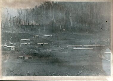
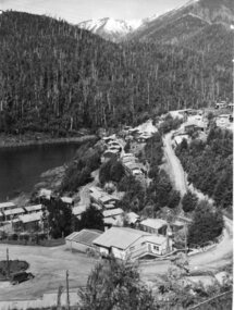
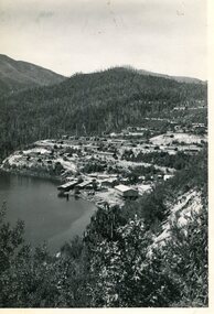 Kiewa Valley Historical Society
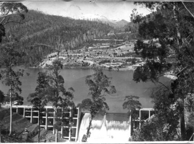
Photo - Bogong Township, March 1944
... The Bogong Township was developed firstly as an accommodation centre (base camp) for construction workers employed under the Kiewa Hydroelectric Scheme. ...In 1940 Field Headquarters for the Kiewa Scheme were established at Bogong with office, workshop facilities and accommodation for workmen, staff and some families constructed. (There had been a 'tent camp' on this site in 1939 but was destroyed by bushfires) Construction of accommodation continued until 1947. A total of 40 houses plus a hostel for single staff, post office, police station, medical centre and primary school all with water and sewerage and electricity supply. The staff hostel was known as Kiewa House and is now occupied by the Education Department. Lake Guy was named after Mr. L.T. Guy who was the Resident Engineer in charge of construction work and associated activities on the Kiewa area. He held this position from 1939 to November 1946 when he was transferred to Head Office. The Bogong Township was developed firstly as an accommodation centre (base camp) for construction workers employed under the Kiewa Hydroelectric Scheme. Due to the influx of European workers into the Township the beautification of the immediate surrounds (gardens etc.) had a distinct European flavour. This environment has been very beneficial for tourism in later years. At the completion of the scheme, in the 1960's, the village was opened to public/tourism use. Strict environmental control has not allowed for any extensive redevelopment in tourist accommodation and basically restricted it to the accommodation initially built for the construction workers. Activities such a bike riding, snow skiing, restricted horse riding and bush walking on the Alpine plains and mountains are now a viable part of the Kiewa Valley Tourist Industry. The lake is one of the many water storage reservoirs used to supply the power stations their main power to run the huge turbines generating the final product, electricityBlack and white photograph of Bogong Township taken March 1944Handwritten on the back of photo - Township March '44bogong village, secv -
 Kiewa Valley Historical Society
Photograph - Bogong Village (7 copies), Approx 1940
... The Bogong Township was developed firstly as an accommodation centre (base camp) for construction workers employed under the Kiewa Hydroelectric Scheme. ...In 1940 Field Headquarters for the Kiewa Scheme were established at Bogong with office, workshop facilities and accommodation for workmen, staff and some families constructed. (There had been a 'tent camp' on this site in 1939 but was destroyed by bushfires) Construction of accommodation continued until 1947. A total of 40 houses plus a hostel for single staff, post office, police station, medical centre and primary school all with water and sewerage and electricity supply. The staff hostel was known as Kiewa House and is now occupied by the Education Department. Lake Guy was named after Mr. L.T. Guy who was the Resident Engineer in charge of construction work and associated activities on the Kiewa area. He held this position from 1939 to November 1946 when he was transferred to Head Office. The Bogong Township was developed firstly as an accommodation centre (base camp) for construction workers employed under the Kiewa Hydroelectric Scheme. Due to the influx of European workers into the Township the beautification of the immediate surrounds (gardens etc.) had a distinct European flavour. This environment has been very beneficial for tourism in later years. At the completion of the scheme, in the 1960's, the village was opened to public/tourism use. Strict environmental control has not allowed for any extensive redevelopment in tourist accommodation and basically restricted it to the accommodation initially built for the construction workers. Activities such a bike riding, snow skiing, restricted horse riding and bush walking on the Alpine plains and mountains are now a viable part of the Kiewa Valley Tourist Industry. The lake is one of the many water storage reservoirs used to supply the power stations their main power to run the huge turbines generating the final product, electricity. Evidence can be seen of the 1939 bushfires.Set of 7 identical black and white photographs of Bogong Village after 1939 bush firesHandwritten on the back of one photo - Bogong Village approx. 1940, after 1939 bush fires. Staff residences to left. Kiewa House, General offices and test lab to the right. Hand drawn map on the back of one photo.bogong village, secv -
 Kiewa Valley Historical Society
Photo - Bogong Village Township, October 8, 1946
... The Bogong Township was developed firstly as an accommodation centre (base camp) for construction workers employed under the Kiewa Hydroelectric Scheme. ...In 1940 Field Headquarters for the Kiewa Scheme were established at Bogong with office, workshop facilities and accommodation for workmen, staff and some families constructed. (There had been a 'tent camp' on this site in 1939 but was destroyed by bushfires) Construction of accommodation continued until 1947. A total of 40 houses plus a hostel for single staff, post office, police station, medical centre and primary school all with water and sewerage and electricity supply. The staff hostel was known as Kiewa House and is now occupied by the Education Department. Lake Guy was named after Mr. L.T. Guy who was the Resident Engineer in charge of construction work and associated activities on the Kiewa area. He held this position from 1939 to November 1946 when he was transferred to Head Office. The Bogong Township was developed firstly as an accommodation centre (base camp) for construction workers employed under the Kiewa Hydroelectric Scheme. Due to the influx of European workers into the Township the beautification of the immediate surrounds (gardens etc.) had a distinct European flavour. This environment has been very beneficial for tourism in later years. At the completion of the scheme, in the 1960's, the village was opened to public/tourism use. Strict environmental control has not allowed for any extensive redevelopment in tourist accommodation and basically restricted it to the accommodation initially built for the construction workers. Activities such a bike riding, snow skiing, restricted horse riding and bush walking on the Alpine plains and mountains are now a viable part of the Kiewa Valley Tourist Industry. The lake is one of the many water storage reservoirs used to supply the power stations their main power to run the huge turbines generating the final product, electricityBlack and white photograph of Bogong Village which appeared in the Herald Sun newspaper on October 8, 1946. Page 13Handwritten on the back - Town of Bogong on a rugged mountain slope above Lake Guy. State Electricity Committee workers on the Kiewa Hydro Electric scheme live here in all electric homes. Stamped on the back - Copyright Not for reproduction Herald Sun Feature Service Melbourne Australiabogong village; lake guy; kiewa hydro electric scheme -
 Kiewa Valley Historical Society
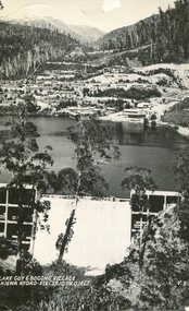
Postcard - Lake Guy and Bogong Village
... The Bogong Township was developed firstly as an accommodation centre (base camp) for construction workers employed under the Kiewa Hydroelectric Scheme. ...In 1940 Field Headquarters for the Kiewa Scheme were established at Bogong with office, workshop facilities and accommodation for workmen, staff and some families constructed. (There had been a 'tent camp' on this site in 1939 but was destroyed by bushfires) Construction of accommodation continued until 1947. A total of 40 houses plus a hostel for single staff, post office, police station, medical centre and primary school all with water and sewerage and electricity supply. The staff hostel was known as Kiewa House and is now occupied by the Education Department. Lake Guy was named after Mr. L.T. Guy who was the Resident Engineer in charge of construction work and associated activities on the Kiewa area. He held this position from 1939 to November 1946 when he was transferred to Head Office. The Bogong Township was developed firstly as an accommodation centre (base camp) for construction workers employed under the Kiewa Hydroelectric Scheme. Due to the influx of European workers into the Township the beautification of the immediate surrounds (gardens etc.) had a distinct European flavour. This environment has been very beneficial for tourism in later years. At the completion of the scheme, in the 1960's, the village was opened to public/tourism use. Strict environmental control has not allowed for any extensive redevelopment in tourist accommodation and basically restricted it to the accommodation initially built for the construction workers. Activities such a bike riding, snow skiing, restricted horse riding and bush walking on the Alpine plains and mountains are now a viable part of the Kiewa Valley Tourist Industry. The lake is one of the many water storage reservoirs used to supply the power stations their main power to run the huge turbines generating the final product, electricityBlack and white photographic postcard of Lake Guy and Bogong Village. Kiewa Hydro electric Project (showing Junction Dam in front)Handwritten on the back of postcard ' Like most of our camps, this looks like something from the Canadian Rockies' Stamped on the back - Valentine's Post Card A genuine photographlake guy, bogong village, secv -
 Kiewa Valley Historical Society
Photo - Bogong Township, September 1953
... The Bogong Township was developed firstly as an accommodation centre (base camp) for construction workers employed under the Kiewa Hydroelectric Scheme. ...In 1940 Field Headquarters for the Kiewa Scheme were established at Bogong with office, workshop facilities and accommodation for workmen, staff and some families constructed. (There had been a 'tent camp' on this site in 1939 but was destroyed by bushfires) Construction of accommodation continued until 1947. A total of 40 houses plus a hostel for single staff, post office, police station, medical centre and primary school all with water and sewerage and electricity supply. The staff hostel was known as Kiewa House and is now occupied by the Education Department. Lake Guy was named after Mr. L.T. Guy who was the Resident Engineer in charge of construction work and associated activities on the Kiewa area. He held this position from 1939 to November 1946 when he was transferred to Head Office. The Bogong Township was developed firstly as an accommodation centre (base camp) for construction workers employed under the Kiewa Hydroelectric Scheme. Due to the influx of European workers into the Township the beautification of the immediate surrounds (gardens etc.) had a distinct European flavour. This environment has been very beneficial for tourism in later years. At the completion of the scheme, in the 1960's, the village was opened to public/tourism use. Strict environmental control has not allowed for any extensive redevelopment in tourist accommodation and basically restricted it to the accommodation initially built for the construction workers. Activities such a bike riding, snow skiing, restricted horse riding and bush walking on the Alpine plains and mountains are now a viable part of the Kiewa Valley Tourist Industry. The lake is one of the many water storage reservoirs used to supply the power stations their main power to run the huge turbines generating the final product, electricityBlack and white photograph of Bogong Township taken from Little Arthur fire track. September 1953Faded handwritten inscription on back - Bogong Township taken from Little Arthur fire track. Sept 1953bogong village, secv -
 Kiewa Valley Historical Society
Photo - First Bogong Camp, September 1950
... The Bogong Township was developed firstly as an accommodation centre (base camp) for construction workers employed under the Kiewa Hydroelectric Scheme. ...In 1940 Field Headquarters for the Kiewa Scheme were established at Bogong with office, workshop facilities and accommodation for workmen, staff and some families constructed. (There had been a 'tent camp' on this site in 1939 but was destroyed by bushfires) Construction of accommodation continued until 1947. A total of 40 houses plus a hostel for single staff, post office, police station, medical centre and primary school all with water and sewerage and electricity supply. The staff hostel was known as Kiewa House and is now occupied by the Education Department. Lake Guy was named after Mr. L.T. Guy who was the Resident Engineer in charge of construction work and associated activities on the Kiewa area. He held this position from 1939 to November 1946 when he was transferred to Head Office. The Bogong Township was developed firstly as an accommodation centre (base camp) for construction workers employed under the Kiewa Hydroelectric Scheme. Due to the influx of European workers into the Township the beautification of the immediate surrounds (gardens etc.) had a distinct European flavour. This environment has been very beneficial for tourism in later years. At the completion of the scheme, in the 1960's, the village was opened to public/tourism use. Strict environmental control has not allowed for any extensive redevelopment in tourist accommodation and basically restricted it to the accommodation initially built for the construction workers. Activities such a bike riding, snow skiing, restricted horse riding and bush walking on the Alpine plains and mountains are now a viable part of the Kiewa Valley Tourist Industry. The lake is one of the many water storage reservoirs used to supply the power stations their main power to run the huge turbines generating the final product, electricityBlack and white photo of Bogong Village. September 1950Handwritten on the back - 1st Bogong Camp. SEC Kiewa Scheme Sept 1950bogong camp, bogong village, secv -
 Kiewa Valley Historical Society
Photo - Bogong Village Township
... The Bogong Township was developed firstly as an accommodation centre (base camp) for construction workers employed under the Kiewa Hydroelectric Scheme. ...In 1940 Field Headquarters for the Kiewa Scheme were established at Bogong with office, workshop facilities and accommodation for workmen, staff and some families constructed. (There had been a 'tent camp' on this site in 1939 but was destroyed by bushfires) Construction of accommodation continued until 1947. A total of 40 houses plus a hostel for single staff, post office, police station, medical centre and primary school all with water and sewerage and electricity supply. The staff hostel was known as Kiewa House and is now occupied by the Education Department. Lake Guy was named after Mr. L.T. Guy who was the Resident Engineer in charge of construction work and associated activities on the Kiewa area. He held this position from 1939 to November 1946 when he was transferred to Head Office. The Bogong Township was developed firstly as an accommodation centre (base camp) for construction workers employed under the Kiewa Hydroelectric Scheme. Due to the influx of European workers into the Township the beautification of the immediate surrounds (gardens etc.) had a distinct European flavour. This environment has been very beneficial for tourism in later years. At the completion of the scheme, in the 1960's, the village was opened to public/tourism use. Strict environmental control has not allowed for any extensive redevelopment in tourist accommodation and basically restricted it to the accommodation initially built for the construction workers. Activities such a bike riding, snow skiing, restricted horse riding and bush walking on the Alpine plains and mountains are now a viable part of the Kiewa Valley Tourist Industry. The lake is one of the many water storage reservoirs used to supply the power stations their main power to run the huge turbines generating the final product, electricityBlack and white photograph of Bogong Village from across Lake Guy. Photo mounted on buff cardbogong village, secv -
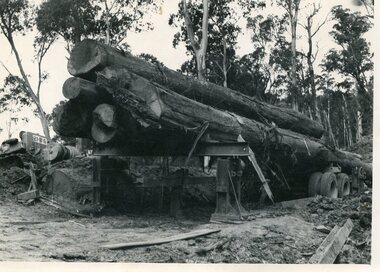
 Kiewa Valley Historical Society
Photo - Mountain Creek Logging Camp, 1955
... The logs could have been milled for timber at the State Electricity Commission's mill at Howman's Gap which provided a much needed source of timber for construction of McKay Creek Power Station which began construction in 1951 and also the camps and houses for the workers and their families. There was a need for housing and infrastructure for an increasing population of workers for the hydro-electric scheme as there was a general shortage of this commodity. ...The logs could have been milled for timber at the State Electricity Commission's mill at Howman's Gap which provided a much needed source of timber for construction of McKay Creek Power Station which began construction in 1951 and also the camps and houses for the workers and their families. There was a need for housing and infrastructure for an increasing population of workers for the hydro-electric scheme as there was a general shortage of this commodity. ...Hume and Hovell discovered the area in 1824 and by the end of the 19th century the valley was transformed by logging, dairy and beef cattle properties and tobacco farms. The logs could have been milled for timber at the State Electricity Commission's mill at Howman's Gap which provided a much needed source of timber for construction of McKay Creek Power Station which began construction in 1951 and also the camps and houses for the workers and their families. There was a need for housing and infrastructure for an increasing population of workers for the hydro-electric scheme as there was a general shortage of this commodity. A timber mill was started in Tawonga by Mates, of Albury, in 1945, and electricity became available in 1946 the S.E.C. bought the mill, and enlarged it. In 1960 it was purchase by a local family, they also started a timber mill in Mt Beauty worked both until 1980 when they closed it. The Tawonga mill and enlarged the mill called Mt. Beauty Timbers Pty Ltd employed approximately 50 people. An historical pictorial record of the general working conditions, type of machinery and vehicles in use in the 1950’s. Note the lack of protective clothing!Black and white photograph of the logging camp at Mountain Creek. November 1955Handwritten on the back of photograph - MOUNTAIN CREEK LOGGING CAMP NOV 55mountain creek logging camp, timber industry, tawonga -
 Kiewa Valley Historical Society
Photo - Logging. Mountain Creek, November 1955, November 1955
... The logs could have been milled for timber at the State Electricity Commission's mill at Howman's Gap which provided a much needed source of timber for construction of McKay Creek Power Station which began construction in 1951 and also the camps and houses for the workers and their families. There was a need for housing and infrastructure for an increasing population of workers for the hydro-electric scheme as there was a general shortage of this commodity. ...The logs could have been milled for timber at the State Electricity Commission's mill at Howman's Gap which provided a much needed source of timber for construction of McKay Creek Power Station which began construction in 1951 and also the camps and houses for the workers and their families. There was a need for housing and infrastructure for an increasing population of workers for the hydro-electric scheme as there was a general shortage of this commodity. ...Hume and Hovell discovered the area in 1824 and by the end of the 19th century the valley was transformed by logging, dairy and beef cattle properties and tobacco farms. The logs could have been milled for timber at the State Electricity Commission's mill at Howman's Gap which provided a much needed source of timber for construction of McKay Creek Power Station which began construction in 1951 and also the camps and houses for the workers and their families. There was a need for housing and infrastructure for an increasing population of workers for the hydro-electric scheme as there was a general shortage of this commodity. A timber mill was started in Tawonga by Mates, of Albury, in 1945, and electricity became available in 1946 the S.E.C. bought the mill, and enlarged it. In 1960 it was purchase by a local family, they also started a timber mill in Mt Beauty worked both until 1980 when they closed it. The Tawonga mill and enlarged the mill called Mt. Beauty Timbers Pty Ltd employed approximately 50 people An historical pictorial record of the general working conditions, type of machinery and vehicles in use in the 1950’s. Black and white photograph of logging at Mountain Creek November 1955Small typed note attached to the back of photo - Logging Mountain Creek November 1955mountain creek logging camp, tawonga, timber industry -
 Kiewa Valley Historical Society
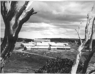
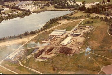
Photograph - Mt Beauty timber Industries, 1960's (estimate only)
... Timber was required for construction of McKay Creek Power Station which began construction in 1951 and also the camps and houses for the workers and their families. There was a need for housing and infrastructure for an increasing population of workers for the hydro-electric scheme as there was a general shortage of this commodity. ...Timber was required for construction of McKay Creek Power Station which began construction in 1951 and also the camps and houses for the workers and their families. There was a need for housing and infrastructure for an increasing population of workers for the hydro-electric scheme as there was a general shortage of this commodity. ...Hume and Hovell discovered the area in 1824 and by the end of the 19th century the valley was transformed by logging, dairy and beef cattle properties and tobacco farms. Timber was required for construction of McKay Creek Power Station which began construction in 1951 and also the camps and houses for the workers and their families. There was a need for housing and infrastructure for an increasing population of workers for the hydro-electric scheme as there was a general shortage of this commodity. A timber mill was started in Tawonga by Mates, of Albury, in 1945, and electricity became available in 1946 the S.E.C. bought the mill, and enlarged it. In 1960 it was purchase by a local family. They also started a timber mill in Mt Beauty and worked both until 1980 when they closed the Tawonga mill and enlarged the mill called Mt. Beauty Timbers Pty Ltd which employed approximately 50 people. A pictorial record of the development of the Mt Beauty community and the local timber industry.Colour photograph of aerial view of Mt Beauty Timber Mills and surrounding area including pondage and part of airfield. Photo taken in 1960’s (estimate only)Handwritten in ink on back of photograph in very faint writing – Recent photo of Mt Beauty Timber Industries Mt Beauty Operationsmt beauty timber industry, timber industry, timber mill, secv