Showing 209 items matching "yarra valley water"
-
 Wonga Park Community Cottage History Group
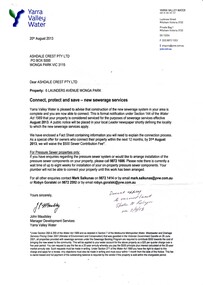
Letter - dated 20 August 2013 from Yarra Valley Water to Ashdale Crest Pty Ltd, advising that sewerage is now available for connection to 6 Launders Avenue Wonga Park
... dated 20 August 2013 from Yarra Valley Water to Ashdale Crest Pty Ltd ...Letter dated 20 August 2013 from Yarra Valley Water to Ashdale Crest Pty Ltd advising that sewerage is now available for connection to 6 Launders Avenue Wonga Park. ...Letter dated 20 August 2013 from Yarra Valley Water to Ashdale Crest Pty Ltd ...Letter dated 20 August 2013 from Yarra Valley Water to Ashdale Crest Pty Ltd advising that sewerage is now available for connection to 6 Launders Avenue Wonga Park. Letter annotated with handwritten note 2/9/2013 Advised connection not required as vacant landOn the first page it is inscribed with the name "Robyn Smiley" and the school "Wonga Park" -
 Whitehorse Historical Society Inc.
Mixed media - Audio Cassette, Talk - Water in the Eastern Suburbs, 12/04/2003
... ...Yarra Valley Water...Cassette of a talk to the Society by David Elliott from Yarra Valley Water on the 'History of the Provision of Water in the Eastern Suburbs' on 12 April 2003....Cassette of a talk to the Society by David Elliott from Yarra Valley Water on the 'History of the Provision of Water in the Eastern Suburbs' on 12 April 2003....Elliott David Yarra Valley Water Water Nunawading & District Historical Society Cassette of a talk to the Society by David Elliott from Yarra Valley Water on the 'History of the Provision of Water in the Eastern Suburbs' on 12 April 2003. ...Cassette of a talk to the Society by David Elliott from Yarra Valley Water on the 'History of the Provision of Water in the Eastern Suburbs' on 12 April 2003.Cassette of a talk to the Society by David Elliott from Yarra Valley Water on the 'History of the Provision of Water in the Eastern Suburbs' on 12 April 2003.elliott, david, yarra valley water, water, nunawading & district historical society -
Canterbury History Group
Article, White, Natalie, Traders seek compo, 19/06/2007 12:00:00 AM
... ... Yarra Valley Water...Progress Leader article about Canterbury Rd traders seeking compensation from Yarra Valley Water re extended sewerage works....Report in the Progress Leader of Canterbury Road traders protesting at their loss of business during the replacement of sewerage pipes in Canterbury Road by Yarra Valley Water. Includes a coloured photograph....Canterbury History Group 190A Canterbury Road Canterbury melbourne Progress Leader article about Canterbury Rd traders seeking compensation from Yarra Valley Water re extended sewerage works. Canterbury Canterbury Road Sewerage and Sanitation Shopkeepers Railway Bridges Yarra Valley Water Report in the Progress Leader of Canterbury Road traders protesting at their loss of business during the replacement of sewerage pipes in Canterbury Road by Yarra Valley Water. ...Report in the Progress Leader of Canterbury Road traders protesting at their loss of business during the replacement of sewerage pipes in Canterbury Road by Yarra Valley Water. Includes a coloured photograph.canterbury, canterbury road, sewerage and sanitation, shopkeepers, railway bridges, yarra valley water -
 Whitehorse Historical Society Inc.
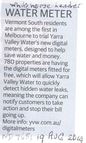
Article, Water Meter, 2019
... ...Yarra Valley Water...Vermont South residents are among the first in Melbourne to trial Yarra Valley Water's new digital meters. Designed to alert customers of water leaks....Vermont South Water Yarra Valley Water Vermont South residents are among the first in Melbourne to trial Yarra Valley Water's new digital meters. ...Vermont South residents are among the first in Melbourne to trial Yarra Valley Water's new digital meters.Vermont South residents are among the first in Melbourne to trial Yarra Valley Water's new digital meters. Designed to alert customers of water leaks.Vermont South residents are among the first in Melbourne to trial Yarra Valley Water's new digital meters. vermont south, water, yarra valley water -
 Whitehorse Historical Society Inc.
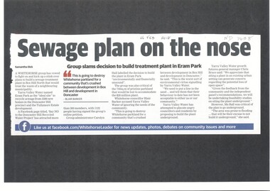
Article, Sewage Plan, 2018
... ...yarra valley water...Yarra Valley Water named Eram Park as the 'ideal site' to recycle sewage from 5500 new homes in the Doncaster Hill precinct and Tullamore Estate development, but local residents are totally opposed it....Whitehorse Historical Society Inc. 2-10 Deep Creek Road Mitcham melbourne sewerage and sanitation yarra valley water city of whitehorse eram park Yarra Valley Water named Eram Park as the 'ideal site' to recycle sewage from 5500 new homes in the Doncaster Hill precinct and Tullamore Estate development, but local residents are totally opposed it. ...Yarra Valley Water named Eram Park as the 'ideal site' to recycle sewage from 5500 new homes in the Doncaster Hill precinct and Tullamore Estate development, but local residents are totally opposed it.sewerage and sanitation, yarra valley water, city of whitehorse, eram park -
 Vision Australia
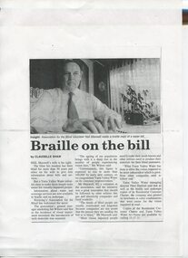
Article - Text, Braille on the bill by Claudelle Shaw
... ...Yarra Valley Water...Newspaper article about Neil Maxwell and the need for Yarra Valley Water to provide Braille water bills for residents who are vision impaired....Vision Australia 454 Glenferrie Road Kooyong melbourne Newspaper article about Neil Maxwell and the need for Yarra Valley Water to provide Braille water bills for residents who are vision impaired. ...Newspaper article about Neil Maxwell and the need for Yarra Valley Water to provide Braille water bills for residents who are vision impaired.1 article photocopied from a newspapernon-fictionelizabeth maxwell, neil maxwell, yarra valley water, advocacy -
 Eltham District Historical Society Inc
Photograph, Liz Pidgeon, Heritage Excursion; Maroondah Aqueduct, 3 September 2016, 3 September 2016
... ...yarra valley water...Property related to Yarra Valley Water, Diamond Creek Newsletter No., 229, August 2016 Heritage Excursion - Maroondah Aqueduct Walk - Saturday 3rd September The Maroondah Aqueduct was once a major link in Melbourne’s water supply system. ...Eltham District Historical Society Inc 728 Main Rd Eltham melbourne Property related to Yarra Valley Water, Diamond Creek Newsletter No., 229, August 2016 Heritage Excursion - Maroondah Aqueduct Walk - Saturday 3rd September The Maroondah Aqueduct was once a major link in Melbourne’s water supply system. ...Property related to Yarra Valley Water, Diamond Creek Newsletter No., 229, August 2016 Heritage Excursion - Maroondah Aqueduct Walk - Saturday 3rd September The Maroondah Aqueduct was once a major link in Melbourne’s water supply system. It was built between 1886 and 1891 to transfer water from the Watts River near Healesville to the Preston Reservoir. It was 66 km in length, made up of 41 km of open channel, 10 km of tunnel through hills and 15 km of pipeline across stream valleys known as inverted siphons. The section of the aqueduct through the Eltham area has been abandoned since the 1980s but the open channel has largely been retained. A recreational path follows the aqueduct reserve. For our excursion on 3rd September we intend to walk along the section of the aqueduct adjacent to Allendale Road. This is a section not visited on previous excursions and includes the transition from open channel to the inverted siphon across the Diamond Creek valley. Apart from the aqueduct itself the main feature of the walk is the extensive views across Eltham North and Diamond Creek. Along the way we will talk about the history of the aqueduct and the area. This easy walk is about 3 km return and will take 2 to 2.5 hours. It will start at 2pm at the junction of Allendale Road with Godber Road and Zig Zag Road North, officially Diamond Creek, but on the northern boundary of Eltham. (Melway ref.12 B10). Born Digitalmaroondah aqueduct, eltham north, activities, eltham district historical society, heritage excursion, yarra valley water, diamond creek -
 Eltham District Historical Society Inc
Photograph, Liz Pidgeon, Heritage Excursion; Maroondah Aqueduct, 3 September 2016, 3 September 2016
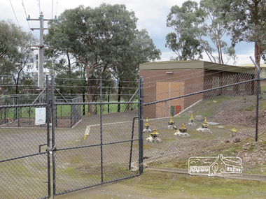
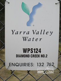
... ...yarra valley water...Sign for Yarra Valley Water at Diamond Creek property Newsletter No., 229, August 2016 Heritage Excursion - Maroondah Aqueduct Walk - Saturday 3rd September The Maroondah Aqueduct was once a major link in Melbourne’s water supply system. ...Eltham District Historical Society Inc 728 Main Rd Eltham melbourne Sign for Yarra Valley Water at Diamond Creek property Newsletter No., 229, August 2016 Heritage Excursion - Maroondah Aqueduct Walk - Saturday 3rd September The Maroondah Aqueduct was once a major link in Melbourne’s water supply system. ...Sign for Yarra Valley Water at Diamond Creek property Newsletter No., 229, August 2016 Heritage Excursion - Maroondah Aqueduct Walk - Saturday 3rd September The Maroondah Aqueduct was once a major link in Melbourne’s water supply system. It was built between 1886 and 1891 to transfer water from the Watts River near Healesville to the Preston Reservoir. It was 66 km in length, made up of 41 km of open channel, 10 km of tunnel through hills and 15 km of pipeline across stream valleys known as inverted siphons. The section of the aqueduct through the Eltham area has been abandoned since the 1980s but the open channel has largely been retained. A recreational path follows the aqueduct reserve. For our excursion on 3rd September we intend to walk along the section of the aqueduct adjacent to Allendale Road. This is a section not visited on previous excursions and includes the transition from open channel to the inverted siphon across the Diamond Creek valley. Apart from the aqueduct itself the main feature of the walk is the extensive views across Eltham North and Diamond Creek. Along the way we will talk about the history of the aqueduct and the area. This easy walk is about 3 km return and will take 2 to 2.5 hours. It will start at 2pm at the junction of Allendale Road with Godber Road and Zig Zag Road North, officially Diamond Creek, but on the northern boundary of Eltham. (Melway ref.12 B10). Born Digitalmaroondah aqueduct, eltham north, activities, eltham district historical society, heritage excursion, diamond creek, yarra valley water, sign -
 Whitehorse Historical Society Inc.
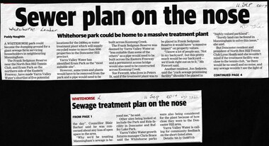
Article, Sewer Treatment Plant, 11/09/2017 12:00:00 AM
... ...Yarra Valley Water...Whitehorse Historical Society Inc. 2-10 Deep Creek Road Mitcham melbourne Frank Sedgman Reserve Yarra Valley Water Sewerage and Sanitation Frank Sedgman Reserve could become a giant sewage farm servicing householders in Manningham. ...Frank Sedgman Reserve could become a giant sewage farm servicing householders in Manningham.Frank Sedgman Reserve could become a giant sewage farm servicing householders in Manningham.Frank Sedgman Reserve could become a giant sewage farm servicing householders in Manningham.frank sedgman reserve, yarra valley water, sewerage and sanitation -
 Eltham District Historical Society Inc
Document, Notice of Decision to Grant a Permit; Ref: E94/306 - Subdivision of 30-34 Diosma Road; 16 November 1994, 16/11/1994
... This permit was eventually overturned following community objection and the land was donated by Yarra Valley Water for use as a community reserve....Eltham District Historical Society Inc 728 Main Rd Eltham melbourne This permit was eventually overturned following community objection and the land was donated by Yarra Valley Water for use as a community reserve. ...This permit was eventually overturned following community objection and the land was donated by Yarra Valley Water for use as a community reserve.The Stokes Orchard Estate collection is typical of housing developments of the late 1970s and 1980s. It was one of the earliest estates in Eltham following the nearby Woodridge Estate development.A4 document consisting of ten pagesAs notedstokes place, eltham, stokes orchard, stokes orchard estate, streets, houses, peter and carla vermey, diosma road, letter of objection, melbourne metropolitan board of works, planning application, reservoir, shire of eltham -
 Eltham District Historical Society Inc
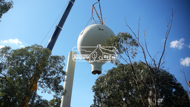
Photograph, Demolition of water tower at 51 Cassells Road, Research, 6 April 2017, 6/4/2017
... Decommissioning works occurred between November 2016 and January 2017, and the tower was removed in March 2017." Source: Yarra Valley Water Eltham Water Project online...Decommissioning works occurred between November 2016 and January 2017, and the tower was removed in March 2017." Source: Yarra Valley Water Eltham Water Project online cassells road, demolition, research (vic.), water tower Digital files only (17 jpg and one two second MP4 files) Demolition of water tower at 51 Cassells Road, Research, 6 April 2017 Photograph Steve Cochrane ..."The water storage tank (the ‘golf ball’ tower) was located in Cassells Road, and for many years it played an important role in supplying the Research and Eltham communities with drinking water. However, due to prior upgrades of water supply infrastructure in the area, these communities are receiving their water supply in a more reliable way. The storage tank was no longer operating and as it no longer served a purpose, the time had come for it to be removed. Decommissioning works occurred between November 2016 and January 2017, and the tower was removed in March 2017." Source: Yarra Valley Water Eltham Water Project onlineDigital files only (17 jpg and one two second MP4 files)cassells road, demolition, research (vic.), water tower -
 Federation University Art Collection
Photograph, Steinfort, Jessie, 'Mushrooms' by Jessie Steinfort, 1998
... And previously, he has been responsible for work on BMW & Mini, Carlton Football club, Melbourne Convention and Exhibition Centre, Melbourne Food & Wine Festival, AAMI, Yarra Valley Water, and Arts Centre Melbourne. From 2008 to 2011 Steinfort was lead designer and front-end web developer at clickDM (now HARDWIRE). ...And previously, he has been responsible for work on BMW & Mini, Carlton Football club, Melbourne Convention and Exhibition Centre, Melbourne Food & Wine Festival, AAMI, Yarra Valley Water, and Arts Centre Melbourne. From 2008 to 2011 Steinfort was lead designer and front-end web developer at clickDM (now HARDWIRE). ...Jessie STEINFORT Steinfort was Studied Graphic Design at the University of Ballarat (later Federation University) After 12 years of working in design studios and advertising agencies, Steinfort is now a Senior Designer at Ogilvy Melbourne. And previously, he has been responsible for work on BMW & Mini, Carlton Football club, Melbourne Convention and Exhibition Centre, Melbourne Food & Wine Festival, AAMI, Yarra Valley Water, and Arts Centre Melbourne. From 2008 to 2011 Steinfort was lead designer and front-end web developer at clickDM (now HARDWIRE). Where he worked with such clients as HOSTPLUS, GSK, UniSuper and Swann Insurance. From 2000 to 2008 Steinfort was a designer at Mediation Communications working on print and interactive projects for; City of Melbourne, City of Greater Geelong, City of Port Phillip, Mentor Education, and ACMA. This item is part of the Federation University Art Collection. The Art Collection features over 2000 works and was listed as a 'Ballarat Treasure' in 2007. Framed photograph of three mushrooms in a black background. This work was won the 1998 Student Acquisition Award. If you can provide information on this artist or artwork please use the email link below. photography, foto, mushrooms, food, close up, macro, colour, photo, jessie steinfort, alumni, available -
 Ringwood and District Historical Society
Document - Folder, Commercial and Retail Property Sales Information, Civic Place and Melbourne Street, Ringwood - 1998
... . - Maroondah City Council Land Information Certificate for 149 149A and 149B Maroondah Highway; number 8 Civic Mall; and numbers 16, 20, 22 & 24 Melbourne Street Mall. - Yarra Valley Water statements relating to encumbrances for Shop 11, 149 Maroondah Highway; Shop 10, 149A Maroondah Highway; Shop 9, 149B Maroondah Highway; numer 8 Civic Place; Unit 3, 20 Melbourne Street; Office 4, 20 Melbourne Street; Shop 7, 22 Melbourne Street; and Shop 8, 24 Melbourne Street. - Land Tax Certificate pertaining to Commonwealth Bank, Civic Place, Ringwood. - Certificate of Title Vol 8892 Fol 906, Lot One on Plan of Subdivision No. 80718, Parish of Ringwood - Hanover Developments P/L - 29th June, 1971..... - Maroondah City Council Land Information Certificate for 149 149A and 149B Maroondah Highway; number 8 Civic Mall; and numbers 16, 20, 22 & 24 Melbourne Street Mall. - Yarra Valley Water statements relating to encumbrances for Shop 11, 149 Maroondah Highway; Shop 10, 149A Maroondah Highway; Shop 9, 149B Maroondah Highway; numer 8 Civic Place; Unit 3, 20 Melbourne Street; Office 4, 20 Melbourne Street; Shop 7, 22 Melbourne Street; and Shop 8, 24 Melbourne Street. - Land Tax Certificate pertaining to Commonwealth Bank, Civic Place, Ringwood. - Certificate of Title Vol 8892 Fol 906, Lot One on Plan of Subdivision No. 80718, Parish of Ringwood - Hanover Developments P/L - 29th June, 1971. ...45 photocopied pages including - Plan of Subdivision No.LP80718, Parish of Ringwood, Victoria, Crown Portion 12(Part) and part of a former government road Ref Vol 8668 Fol 745. - Vendors Statement, Planning Certificate and Heritage Council (Victoria) Certificate issued for 20 Melbourne Street, Ringwood. - Maroondah City Council Land Information Certificate for 149 149A and 149B Maroondah Highway; number 8 Civic Mall; and numbers 16, 20, 22 & 24 Melbourne Street Mall. - Yarra Valley Water statements relating to encumbrances for Shop 11, 149 Maroondah Highway; Shop 10, 149A Maroondah Highway; Shop 9, 149B Maroondah Highway; numer 8 Civic Place; Unit 3, 20 Melbourne Street; Office 4, 20 Melbourne Street; Shop 7, 22 Melbourne Street; and Shop 8, 24 Melbourne Street. - Land Tax Certificate pertaining to Commonwealth Bank, Civic Place, Ringwood. - Certificate of Title Vol 8892 Fol 906, Lot One on Plan of Subdivision No. 80718, Parish of Ringwood - Hanover Developments P/L - 29th June, 1971. -
 Emerald Museum & Nobelius Heritage Park
Administrative record - Nobelius Nursery Cash Book, 1895-1908, 21 August 1895 - 12 October 1903
... yarra-valley-and-the-dandenong-ranges The Cash Accounts contain the names and transaction details of all Gembrook Nursery clients. As well as private individuals, clients also included the following: Fitzroy City Council (p.2, 23, 41, 58. 93); Collingwood Council (p.2, 11, 54, 62, 71, 93); Lands Dept (p.2,5, 28, 30, 45, 61, 73); Melbourne Water Supply (p. 2); Victorian Railways (p.4, 6, 7,17,19, 20, 21, 22, 23, 24, 25, 27, 29, 31, 32, 33, 35, 37, 47......); Salvation Army (p.5, 36, 72, 94); Boroondara Council (p.11, 37, 57, 69); Kew Council (p.12, 34, 55); Caulfied Shire Council (p.14, 35, 37,53, 69, 90, 93, 108); City of Melbourne (p. 26, 54, 96); Narre Warren Library (p. 44)., Public Works Dept (p. 55); Nunawading Shire Council (p. 70); Prahran Shire Council (p. 91, 102, 108); Dept of Agriculture N.Z. ...The Cash Accounts contain the names and transaction details of all Gembrook Nursery clients. As well as private individuals, clients also included the following: Fitzroy City Council (p.2, 23, 41, 58. 93); Collingwood Council (p.2, 11, 54, 62, 71, 93); Lands Dept (p.2,5, 28, 30, 45, 61, 73); Melbourne Water Supply (p. 2); Victorian Railways (p.4, 6, 7,17,19, 20, 21, 22, 23, 24, 25, 27, 29, 31, 32, 33, 35, 37, 47......); Salvation Army (p.5, 36, 72, 94); Boroondara Council (p.11, 37, 57, 69); Kew Council (p.12, 34, 55); Caulfied Shire Council (p.14, 35, 37,53, 69, 90, 93, 108); City of Melbourne (p. 26, 54, 96); Narre Warren Library (p. 44)., Public Works Dept (p. 55); Nunawading Shire Council (p. 70); Prahran Shire Council (p. 91, 102, 108); Dept of Agriculture N.Z.(p. 93); Hawkesbury Ag College (p. 93); Cremorne Nursery (p. ......., 94); Stawell Shire Council (p. 95); Monbulk Jam Factory (p. 100, Euroa shire Council (p. 108))The accounts also track Nobelius' travel expenses.The cash account books are historically, and socially significant as the entries give an insight into the growth of the company and the details payments from local and other government offices and overseas customers as well as significant companies associations and people. The earlier account books also detail wage payments.Hard cover cash book, with maroon embossed cover (alligator print cover), inner cover marbled front and back, cash book has a total of 139 pages all used, date starts 1895 and concludes in 1908c. a. nobelius & sons, gembrook nurseries, horticulture, accounting, emerald -
 Emerald Museum & Nobelius Heritage Park
Administrative record - Nobelius Nursery Cash book, October 1903- December 1910, 16/10/1903 - 18/12/1910
... yarra-valley-and-the-dandenong-ranges The Cash Accounts contain the names and transaction details of all Gembrook Nursery clients. As well as private individuals, clients also included the following: Fitzroy City Council (p.2, 23, 41, 58. 93); Collingwood Council (p.2, 11, 54, 62, 71, 93); Lands Dept (p.2,5, 28, 30, 45, 61, 73); Melbourne Water Supply (p. 2); Victorian Railways (p.4, 6, 7,17,19, 20, 21, 22, 23, 24, 25, 27, 29, 31, 32, 33, 35, 37, 47......); Salvation Army (p.5, 36, 72, 94); Hawthorn Council (p.11, 37, 57, 69); Kew Council (p.12, 34, 55); Caulfied Shire Council (p.14, 35, 37,53, 69, 90, 93, 108); City of Melbourne (p. 26, 54, 96); Narre Warren Library (p. 44)., Public Works Dept (p. 55); Nunawading Shire Council (p. 70); Prahran Shire Council (p. 91, 102, 108); Dept of Agriculture N.Z. ...The Cash Accounts contain the names and transaction details of all Gembrook Nursery clients. As well as private individuals, clients also included the following: Fitzroy City Council (p.2, 23, 41, 58. 93); Collingwood Council (p.2, 11, 54, 62, 71, 93); Lands Dept (p.2,5, 28, 30, 45, 61, 73); Melbourne Water Supply (p. 2); Victorian Railways (p.4, 6, 7,17,19, 20, 21, 22, 23, 24, 25, 27, 29, 31, 32, 33, 35, 37, 47......); Salvation Army (p.5, 36, 72, 94); Hawthorn Council (p.11, 37, 57, 69); Kew Council (p.12, 34, 55); Caulfied Shire Council (p.14, 35, 37,53, 69, 90, 93, 108); City of Melbourne (p. 26, 54, 96); Narre Warren Library (p. 44)., Public Works Dept (p. 55); Nunawading Shire Council (p. 70); Prahran Shire Council (p. 91, 102, 108); Dept of Agriculture N.Z.(p. 93); Hawkesbury Ag College (p. 93); Cremorne Nursery (p. ......., 94); Stawell Shire Council (p. 95); Monbulk Jam Factory (p. 100, Euroa shire Council (p. 108))The accounts also track Nobelius' travel expenses.The cash account books are historically, and socially significant as the entries give an insight into the growth of the company and the details payments from local and other government offices and overseas customers as well as significant companies associations and people. The earlier account books also detail wage payments.Hard cover cash book, brown leather binding, black cover, pink marbled end paper, book has 239 pages all used, date starts 16th October 1903 and ends 18th December 1910. c. a. nobelius & sons, gembrook nurseries, horticulture, accounting, emerald -
Emerald Museum & Nobelius Heritage Park
Domestic object - Tea set
... Emerald Museum & Nobelius Heritage Park 5 Crichton Rd Emerald yarra-valley-and-the-dandenong-ranges This tea set was presented to Harold Leggett by the Emerald Mechanics Institute for his services as secretary to the committee 1926 - 1938 This tea set is significant because the recipient was a well-known local man in the early part of the twentieth century and the Mechanics Institute was an important Emerald institution Emerald Mechanics Institute Leggett Tea set Silver Plate Tea Set consisting of tea pot, hot water pot and sugar bowl Domestic object Tea set ...This tea set was presented to Harold Leggett by the Emerald Mechanics Institute for his services as secretary to the committee 1926 - 1938This tea set is significant because the recipient was a well-known local man in the early part of the twentieth century and the Mechanics Institute was an important Emerald institution Silver Plate Tea Set consisting of tea pot, hot water pot and sugar bowlemerald mechanics institute, leggett, tea set -
Emerald Museum & Nobelius Heritage Park
Domestic object - Hot water pot
... Emerald Museum & Nobelius Heritage Park 5 Crichton Rd Emerald yarra-valley-and-the-dandenong-ranges This tea set was presented to Harold Leggett by the Emerald Mechanics Institute for his services as secretary to the committee 1926 - 1938 This tea set is significant because the recipient was a well-known local man in the early part of the twentieth century and the Mechanics Institute was an important Emerald institution Emerald Mechanics Institute Leggett Tea set Under the pot - "CHALLENGE EPNS A1" Silver Plate "Challenge" Hot Water Pot Domestic object Hot water pot ...This tea set was presented to Harold Leggett by the Emerald Mechanics Institute for his services as secretary to the committee 1926 - 1938This tea set is significant because the recipient was a well-known local man in the early part of the twentieth century and the Mechanics Institute was an important Emerald institution Silver Plate "Challenge" Hot Water PotUnder the pot - "CHALLENGE EPNS A1"emerald mechanics institute, leggett, tea set -
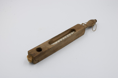 Emerald Museum & Nobelius Heritage Park
Tool - Floating Dairy Thermometer, Circa 1930
... yarra-valley-and-the-dandenong-ranges This Floating Dairy Thermometer was used on the A’Vard farm between 1930 and 1964. It is designed to enable the easy measuring of the temperature of liquids. In particular it facilitates checking whether dairy is at the right temperature for cheesemaking, churning and freezing. It was made to remain at the surface of the liquid, allowing workers to accurately take temperature readings with relative ease. Similar models of floating thermometers were used to measure the temperature of bath water ...This Floating Dairy Thermometer was used on the A’Vard farm between 1930 and 1964. It is designed to enable the easy measuring of the temperature of liquids. In particular it facilitates checking whether dairy is at the right temperature for cheesemaking, churning and freezing. It was made to remain at the surface of the liquid, allowing workers to accurately take temperature readings with relative ease. Similar models of floating thermometers were used to measure the temperature of bath water in hospitals; these functioned identically but had different markers for their different use case.This was a specialised tool used historically in the local dairy farming industry.A glass vial thermometer housed in a wooden case. The glass thermometer has temperature markings visible from 20 to 120 degrees Fahrenheit. There are long gaps with rounded ends on the front and rear of the wooden casing, allowing a user to see the temperature markings and labels. There is also a round hole in the front and rear of the wooden casing near the bottom, exposing the tip of the thermometer. At the top of the wooden casing is a handle, with string passed through a small hole allowing for the suspension of the thermometer from the string.Front side of glass vial, middle: "Made / in Germany" Front side of glass vial, upper: "FLOATING DAIRY THERMOMETER" Rear side of glass vial, 85 degrees: "85 Cheese" Rear side of glass vial, 62 degrees: "62 Churning" Rear side of glass vial, 32 degrees: "32 Freezing"a’vard family, farming, tools, 20th century, a’vard dairy farm, dairy -
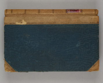
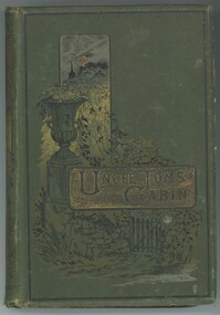 Emerald Museum & Nobelius Heritage Park
Book - Fiction Book, Harriet Beecher Stowe, Uncle Tom's Cabin, 1889
... yarra-valley-and-the-dandenong-ranges This book, Uncle Tom's Cabin was the best selling novel in the 19th century in the USA. It was given to Alexander Ure in 1889, the son of Scottish migrants, John and Jane Ure who settled on acreage north of Gembrook in 1874. They called their property 'Silver Wells' because of finding a pure and plentiful water ...This book, Uncle Tom's Cabin was the best selling novel in the 19th century in the USA. It was given to Alexander Ure in 1889, the son of Scottish migrants, John and Jane Ure who settled on acreage north of Gembrook in 1874. They called their property 'Silver Wells' because of finding a pure and plentiful water source when digging their initial well. Silver Wells became the commercial centre of the early Gembrook settlement with shops, post office etc. When the train came through in 1900 the Gembrook commercial centre shifted to its present location, near the railway station. The Ure family continued to play a significant role in the Gembrook community.The Ure family of 'Silver Wells' was significant in the early history of Gembrook.Moss green hard cover book with title embossed on gold panel. 326 pages.On front cover printed: 'UNCLE TOM'S CABIN' On page i handwritten: 'Alexander Ure / A Present / from Mr & Mrs Wood / Cot 3rd 1889'alexander ure, uncle tom's cabin, 1889, silver wells -
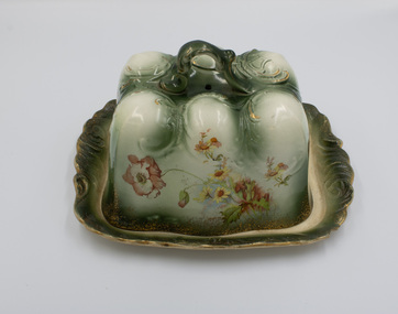 Emerald Museum & Nobelius Heritage Park
Ceramic - Cheese Plate & Cover
... Emerald Museum & Nobelius Heritage Park 5 Crichton Rd Emerald yarra-valley-and-the-dandenong-ranges This ornate ceramic cheese plate and cover which is probably early 20th century was owned by the Ure family. Scottish migrants, John and Jane Ure. They settled on acreage north of Gembrook in 1874 which they called 'Silver Wells' because of finding a pure and plentiful water source when digging their initial well. ...This ornate ceramic cheese plate and cover which is probably early 20th century was owned by the Ure family. Scottish migrants, John and Jane Ure. They settled on acreage north of Gembrook in 1874 which they called 'Silver Wells' because of finding a pure and plentiful water source when digging their initial well. Silver Wells became the commercial centre of the early Gembrook settlement with shops, post office etc. When the train came through in 1900 the Gembrook commercial centre shifted to its present location, near the railway station. The Ure family continued to play a significant role in the Gembrook community. Items were donated by Jean WorrellThe Ure family of 'Silver Wells' was significant in the early history of Gembrook. This ornate ceramic piece is indicative of their prosperity.Ceramic cheese cover and plate. Ornate design in green and white with floral design around all sides. Gold edging. Handle.silver wells, 1900s, ure -
 Emerald Museum & Nobelius Heritage Park
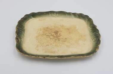
Ceramic - Plate
... yarra-valley-and-the-dandenong-ranges This plate which is part of an ornate cheese cover and plate appears to be Edwardian. It was owned by the Ure family. Scottish migrants, John and Jane Ure, who settled on acreage north of Gembrook in 1874. They called their property 'Silver Wells' because of finding a pure and plentiful water ...This plate which is part of an ornate cheese cover and plate appears to be Edwardian. It was owned by the Ure family. Scottish migrants, John and Jane Ure, who settled on acreage north of Gembrook in 1874. They called their property 'Silver Wells' because of finding a pure and plentiful water source when digging their initial well. Silver Wells became the commercial centre of the early Gembrook settlement with shops, post office etc. When the train came through in 1900 the Gembrook commercial centre shifted to its present location, near the railway station. The Ure family continued to play a significant role in the Gembrook community. Items were donated by Jean WorrellThe Ure family of 'Silver Wells' was significant in the early history of Gembrook and this ornate ceramic piece is indicative of their prosperity.Green & White coloured ceramic plate which is part of a matching set comprising a cheese cover and plate.silver wells, ure, 1900s -
 Emerald Museum & Nobelius Heritage Park
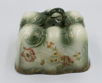
Ceramic - Ceramic cheese cover
... yarra-valley-and-the-dandenong-ranges This cheese plate and cover which is probably Edwardian was owned by the Ure family. Scottish migrants, John and Jane Ure settled on acreage north of Gembrook in 1874. They called their property 'Silver Wells' because of finding a pure and plentiful water ...This cheese plate and cover which is probably Edwardian was owned by the Ure family. Scottish migrants, John and Jane Ure settled on acreage north of Gembrook in 1874. They called their property 'Silver Wells' because of finding a pure and plentiful water source when digging their initial well. Silver Wells became the commercial centre of the early Gembrook settlement with shops, post office etc. When the train came through in 1900 the Gembrook commercial centre shifted to its present location, near the railway station. The Ure family continued to play a significant role in the Gembrook community. Items were donated by Jean WorrellThe Ure family of 'Silver Wells' was significant in the early history of Gembrook. This ornate cheese cover is indicative of their prosperity.Ornate rectangular ceramic cheese cover with handle on top and floral design on all four sides.silver wells, ure, 1900s -
 Emerald Museum & Nobelius Heritage Park
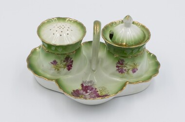
Ceramic - Ceramic cruet set consisting of stand, pepper container & salt container
... yarra-valley-and-the-dandenong-ranges This cruet set was owned by the Ure family. Scottish migrants, John and Jane Ure settled on acreage north of Gembrook in 1874. They called their property 'Silver Wells' because of finding a pure and plentiful water source when digging their initial well. ...This cruet set was owned by the Ure family. Scottish migrants, John and Jane Ure settled on acreage north of Gembrook in 1874. They called their property 'Silver Wells' because of finding a pure and plentiful water source when digging their initial well. Silver Wells became the commercial centre of the early Gembrook settlement with shops, post office etc. When the train came through in 1900 the Gembrook commercial centre shifted to its present location, near the railway station. The Ure family continued to play a significant role in the Gembrook community. Items were donated by Jean WorrellThe Ure family of 'Silver Wells' was significant in the early history of Gembrook.Ceramic cruet set consisting of a stand with a handle and containing a pepper container and salt container which are removable. Red floral decoration with some green on a white background. Gold rim.1889, silver wells -
 Emerald Museum & Nobelius Heritage Park
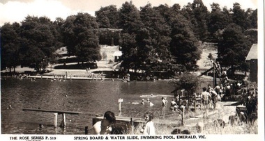
Postcard - B/W, Spring Board and Water Slide, Swimming Pool, Emerald, Vic
... Emerald Museum & Nobelius Heritage Park 5 Crichton Rd Emerald yarra-valley-and-the-dandenong-ranges Recreational activities and provisions at Emerald Park Lake circa 1940s emerald park lake rose series swimming pool FRONT: 'The Rose Series', P 519 COPYRIGHT' 'Springboard & Water Slide, Swimming Pool, Emerald, Vic.' ...Recreational activities and provisions at Emerald Park Lake circa 1940sPostcard made from black and white photograph. Many bathers at Emerald Park Lake Swimming Pool. Springboard in foreground, water slide on right to the rear. FRONT: 'The Rose Series', P 519 COPYRIGHT' 'Springboard & Water Slide, Swimming Pool, Emerald, Vic.' REAR: Rose illustration in centre, flanked by 'POST CARD' and "The "Rose" Series Deluxe', 'A Real Photograph Produced in Australia'. Along left: 'Published by the Rose Stereograph Co., Armadale, Victoria'.emerald park lake, rose series, swimming pool -
Marysville & District Historical Society
THE TRIANGLE NEWS-VOL 2 NO 35-NOVEMBER 11 1977
... Marysville & District Historical Society 39 Darwin Street Marysville yarra-valley-and-the-dandenong-ranges marysville victoria australia wirreanda a winner water tapping debutante ball photos super bags marysville senior citizens debutante ball bingo community care centre for sale boyles rainfall open house manuel's waterworks trust auction fire brigade scouts kindergarten roster 1st marysville l.a. wanted to buy golf church of england missionary sunday crossways restaurant cricket THE TRIANGLE NEWS-VOL 2 NO 35-NOVEMBER 11 1977 ...marysville, victoria, australia, wirreanda a winner, water tapping, debutante ball photos, super bags, marysville senior citizens, debutante ball, bingo, community care centre, for sale, boyles, rainfall, open house, manuel's, waterworks trust, auction, fire brigade, scouts, kindergarten roster, 1st marysville l.a., wanted to buy, golf, church of england missionary sunday, crossways restaurant, cricket -
Marysville & District Historical Society
THE TRIANGLE NEWS-VOL 3 NO 7-MARCH 31 1978
... Marysville & District Historical Society 39 Darwin Street Marysville yarra-valley-and-the-dandenong-ranges marysville victoria australia the triangle news gains international award red cross thank you marysville water supply contaminated congratulations golden wedding golfers inter-school athletics sports kindergarten primary school mothers' club narbethong primary school rainfall lake mountain works boots mcleod THE TRIANGLE NEWS-VOL 3 NO 7-MARCH 31 1978 ...marysville, victoria, australia, the triangle news gains international award, red cross, thank you, marysville water supply contaminated, congratulations, golden wedding, golfers, inter-school athletics sports, kindergarten, primary school mothers' club, narbethong primary school, rainfall, lake mountain works, boots mcleod -
Marysville & District Historical Society
THE TRIANGLE NEWS-VOL 3 NO 10-APRIL 21 1978
... Marysville & District Historical Society 39 Darwin Street Marysville yarra-valley-and-the-dandenong-ranges marysville victoria australia water supply thank you 50th wedding anniversary community care centre jumbucks fleece opponents thank you from beryl & joe greatorex kindergarten get well senior citizens marysville primary school mothers' club marysville uniting church wanted marysville swimming and life saving club football 1st marysville girl guide l.a. helicopter crash orienteering running thought sport fruit salad farm handyman available THE TRIANGLE NEWS-VOL 3 NO 10-APRIL 21 1978 ...marysville, victoria, australia, water supply, thank you, 50th wedding anniversary, community care centre, jumbucks fleece opponents, thank you from beryl & joe greatorex, kindergarten, get well, senior citizens, marysville primary school mothers' club, marysville uniting church, wanted, marysville swimming and life saving club, football, 1st marysville girl guide l.a., helicopter crash, orienteering running thought sport, fruit salad farm, handyman available -
Marysville & District Historical Society
THE TRIANGLE NEWS-VOL 3 NO 13-MAY 12 1978
... Marysville & District Historical Society 39 Darwin Street Marysville yarra-valley-and-the-dandenong-ranges marysville victoria australia water-all clear community care centre brownies a hit football indoor bowls guess the weight-pumpkin golf manna gum happy birthday lost crossways restaurant & motel miss australia quest cacamboura's ladies guild golf club dinner dance marysville primary school marysville primary school mothers' club help-transport handyman fruit salad farm THE TRIANGLE NEWS-VOL 3 NO 13-MAY 12 1978 ...marysville, victoria, australia, water-all clear, community care centre, brownies a hit, football, indoor bowls, guess the weight-pumpkin, golf, manna gum, happy birthday, lost, crossways restaurant & motel, miss australia quest, cacamboura's, ladies guild, golf club dinner dance, marysville primary school, marysville primary school mothers' club, help-transport, handyman, fruit salad farm -
Marysville & District Historical Society
THE TRIANGLE NEWS-VOL 3 NO 36-NO DATE
... Marysville & District Historical Society 39 Darwin Street Marysville yarra-valley-and-the-dandenong-ranges marysville victoria australia wirreanda is over water red cross marysville uniting church community care centre primary school enrolments historical society in hospital wanted to buy tennis club senior citizens bessemer party christ church ladies guild dance congratulations lady bowlers fire brigade footy club tupperware party rainfall golf news kinder roster girl guides l.a. ladies bushwalking toddler group cricket news THE TRIANGLE NEWS-VOL 3 NO 36-NO DATE ...marysville, victoria, australia, wirreanda is over, water, red cross, marysville uniting church, community care centre, primary school enrolments, historical society, in hospital, wanted to buy, tennis club, senior citizens, bessemer party, christ church ladies guild, dance, congratulations lady bowlers, fire brigade, footy club, tupperware party, rainfall, golf news, kinder roster, girl guides l.a., ladies bushwalking, toddler group, cricket news -
Marysville & District Historical Society
THE TRIANGLE NEWS-VOL 3 NO 37-10 NOVEMBER 1978
... Marysville & District Historical Society 39 Darwin Street Marysville yarra-valley-and-the-dandenong-ranges marysville victoria australia final call primary school enrolment brownie-guides new faces scouts & cubs committee meeting community care centre australian democrats in hospital for sale found swimming club senior citizens rainfall marysville water fisherman of the week kindergarten annual dinner pottery classes commencing cricket the future of triangle news golf poison pen letter marysville primary school council fruit salad farm THE TRIANGLE NEWS-VOL 3 NO 37-10 NOVEMBER 1978 ...marysville, victoria, australia, final call, primary school enrolment, brownie-guides, new faces, scouts & cubs committee meeting, community care centre, australian democrats, in hospital, for sale, found, swimming club, senior citizens, rainfall, marysville water, fisherman of the week, kindergarten, annual dinner, pottery classes commencing, cricket, the future of triangle news, golf, poison pen letter, marysville primary school council, fruit salad farm