Showing 32508 items matching "yarra-river"
-
 Kew Historical Society Inc
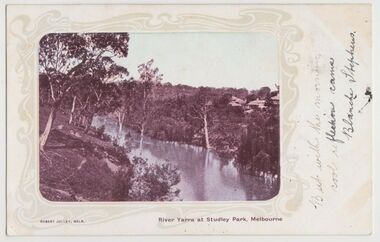
Postcard, River Yarra at Studley Park, Melbourne, 1900-04
... River Yarra at Studley Park, Melbourne...Monochrome postcard titled lower right: “RIVER YARRA AT STUDLEY PARK, MELBOURNE”. The postcard was produced by ROBERT JOLLEY, MELB, (active 1900-1904). ...Monochrome postcard of the River Yarra in Studley Park. The view is of the Yarra and its banks, with Kew on the left and Abbotsford on the right, as it appeared in the years 1900-1904. ..."RIVER YARRA AT STUDLEY PARK, MELBOURNE"...It lacks a postage stamp and postmark. river yarra -- kew (vic.) postcards -- kew postcards -- studley park robert jolley "RIVER YARRA AT STUDLEY PARK, MELBOURNE" Monochrome postcard of the River Yarra in Studley Park. ...Monochrome postcard titled lower right: “RIVER YARRA AT STUDLEY PARK, MELBOURNE”. The postcard was produced by ROBERT JOLLEY, MELB, (active 1900-1904). The photo is positioned to the left of the card and framed by an art nouveau design. A handwritten annotation on the front reads “BUT WITH THE MORNING / COOL REFLECTION CAME / BLANCHE STEPHENS”. On the reverse, there is a handwritten address in black ink to: MISS L STEPHENS / 26 WEST TERRACE / ADELAIDE. There is no division on the reverse of the postcard, dating it to before 1905. It lacks a postage stamp and postmark. Monochrome postcard of the River Yarra in Studley Park. The view is of the Yarra and its banks, with Kew on the left and Abbotsford on the right, as it appeared in the years 1900-1904. On the Abbotsford side of the river, there are a number of weeping willows lining the banks and houses on the hillside. The Studley Park side of the river includes some remnant vegetation and meandering walking tracks. Three very small figures are sitting on the Kew side. "RIVER YARRA AT STUDLEY PARK, MELBOURNE"river yarra -- kew (vic.), postcards -- kew, postcards -- studley park, robert jolley -
 Kew Historical Society Inc
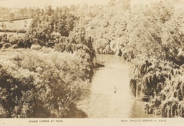
Photograph, River Yarra at Kew, c.1927
... River Yarra at Kew...The River Yarra was a popular subject for photographic postcards. ...Small, sepia coloured real photo postcard of the River Yarra at Kew. The bird's eye view, presumably taken from Victoria Street Bridge shows the banks of the Yarra in the foreground densely planted with weeping willows. ..."RIVER YARRA AT KEW / REAL PHOTO SERIES M. 2908 "...The postcards provide an interesting perspective of plantings on the banks of the Yarra at various periods. real photo postcards yarra river -- kew (vic.) postcards -- 1920s "RIVER YARRA AT KEW / REAL PHOTO SERIES M. 2908 " Small, sepia coloured real photo postcard of the River Yarra at Kew. ...The River Yarra was a popular subject for photographic postcards. The postcards provide an interesting perspective of plantings on the banks of the Yarra at various periods. Small, sepia coloured real photo postcard of the River Yarra at Kew. The bird's eye view, presumably taken from Victoria Street Bridge shows the banks of the Yarra in the foreground densely planted with weeping willows. There is also canoe in the foreground. The expanse of lawn in the middle ground is that of 'Swinton', the tower of which can faintly be seen at the top centre of the view. "RIVER YARRA AT KEW / REAL PHOTO SERIES M. 2908 "real photo postcards, yarra river -- kew (vic.), postcards -- 1920s -
 Kew Historical Society Inc
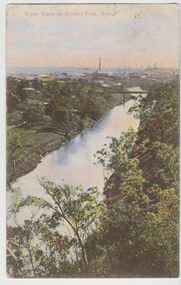
Postcard, River Yarra at Studley Park, Kew, c.1908
... River Yarra at Studley Park, Kew...Colour-tinted postcard, titled in red upper left: “RIVER YARRA AT STUDLEY PARK, KEW”. On the divided reverse, the card is addressed to “MISS JOLLEY / MELB. ...Hand-tinted postcard of the River Yarra in Studley Park, Kew. The birds-eye view is of a bridge on the Yarra (Johnston Street?) ...“RIVER YARRA AT STUDLEY PARK, KEW”...“RIVER YARRA AT STUDLEY PARK, KEW” Hand-tinted postcard of the River Yarra in Studley Park, Kew. ...Colour-tinted postcard, titled in red upper left: “RIVER YARRA AT STUDLEY PARK, KEW”. On the divided reverse, the card is addressed to “MISS JOLLEY / MELB. TRAM & O[MNIBUS]. CO / BOURKE STREET, MELB”. The sender has dated the card 21.12.08. In the upper right corner, there is a pink Victorian one penny postage stamp; sent from Melbourne on 22DE 08. (The division of the reverse of the postcard, allowing a message to be written on one half and the address on the other, was not permitted in Australia until 1905.) The manufacturer of the postcard is indicated by the initials “W.T.P”, printed in a green floral diamond, printed centre top. This was the trademark of WT Pater, printers & stationers. William Thompson Pater was born in Melbourne in 1861. His business at 271 Little Collins Street offered Christmas cards, booklets, calendars, and leather goods as well as postcards and albums.Hand-tinted postcard of the River Yarra in Studley Park, Kew. The birds-eye view is of a bridge on the Yarra (Johnston Street?) linking Kew and Abbotsford as it appeared in c.1908. On the Abbotsford side of the river, fields lead down to the river, with some remnant trees. The Kew side of the river, in contrast, due to its steep banks, retains its original vegetation. In the distance is industrial development, in what might be Fairfield and Alphington.“RIVER YARRA AT STUDLEY PARK, KEW”river yarra -- kew (vic.), william thompson pater, w.t.p., postcards -- kew, postcards -- studley park, bridges - yarra river -- kew (vic.) -
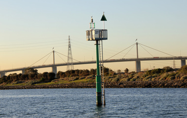
 Ballarat Heritage Services
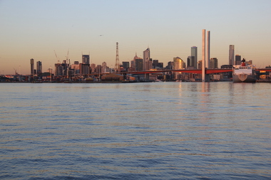
Photograph - Digital photographs, Yarra River Melbourne Docklands Bolte Bridge, 2015
... Yarra River Melbourne Docklands Bolte Bridge...Digital Images of the Yarra River Melbourne Docklands and Bolte Bridge....Yarra River Melbourne Docklands, Melbourne, VIC, Australia...Ballarat Heritage Services PO Box 2209 Bakery Hill Post Office goldfields yarra river melbourne docklands yarra river dock docklands shipping port channel water bridge bolte bridge Digital Images of the Yarra River Melbourne Docklands and Bolte Bridge. ...Digital Images of the Yarra River Melbourne Docklands and Bolte Bridge.yarra river melbourne docklands, yarra river, dock, docklands, shipping, port, channel, water, bridge, bolte bridge -
 Kew Historical Society Inc
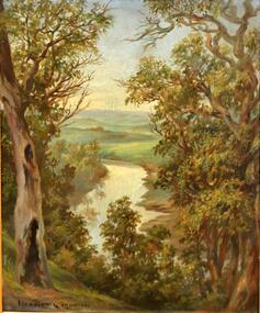
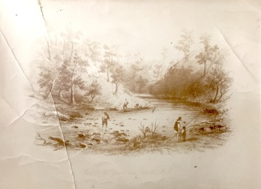
Painting, Herbert J Woodhouse, River Yarra Near Dights Falls, c.1892
... River Yarra Near Dights Falls...One of the paintings singled out for praise was: ‘A very effective river scene at Willsmere, aptly named A Midstream Mirror, ... a picture powerful in its effective reflection of sunlight in the river.’ ...Framed oil painting on board of the River Yarra at Studley Park, Kew, by Herbert James Woodhouse (1858-1937). ...Verso, written by artist: "River Yarra Near Dights Falls"...River Yarra Near Dights Falls Painting Painting Herbert J Woodhouse ...Herbert James Woodhouse (1854-1937) was born in Essex and arrived in Australia with his family in 1857. A painter-lithographer like his father and three of his brothers, he was a prizewinner in the South Australian Society of Arts exhibition of 1885. He also received commendations in exhibitions at the Victorian Academy of Arts and the New South Wales Arts Society. At an exhibition of his paintings at Scott’s Hotel in Collins Street in 1892, the reviewer for Table Talk noted that the ‘artist paints almost solely in the open air, and his studies are generally carried out during the trips of the Victorian Sketching Club’. One of the paintings singled out for praise was: ‘A very effective river scene at Willsmere, aptly named A Midstream Mirror, ... a picture powerful in its effective reflection of sunlight in the river.’ Herbert Woodhouse died in Geelong in June 1937, aged 82, and was buried in the Eastern Cemetery. A number of his sketchbooks are held in the collection of the State Library of Victoria.Framed oil painting on board of the River Yarra at Studley Park, Kew, by Herbert James Woodhouse (1858-1937). The artist has framed the narrow painting with trees in the foreground and a view of the Yarra River and rolling hills in the background. Verso, written by artist: "River Yarra Near Dights Falls"australian art - 19th century, herbert james woodhouse (1854-1937), yarra river - studley park -
 Kew Historical Society Inc
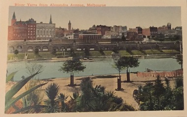
Postcard, River Yarra from Alexandra Avenue, Melbourne, c.1911
... River Yarra from Alexandra Avenue, Melbourne...River Yarra from Alexandra Avenue, Melbourne. ..."River Yarra from Alexandra Avenue, Melbourne"...Those postcards which are early views of Melbourne must have been produced commercially for some decades from the early part of the 20th century. postcards george and edith weir alexandra avenue - melbourne, yarra river weir collection "River Yarra from Alexandra Avenue, Melbourne" River Yarra from Alexandra Avenue, Melbourne. ...Collection of thirty-nine postcards donated by Jillian Rigby which had been owned by her grandparents, George and Edith Weir, who from c.1917 lived at 84 Princess Street, Kew. The mostly 'mint' postcards were purchased in Victoria and while travelling overseas. The sole dated postcard is dated from 1929. The postcards are numbered sequentially from 2017.0058.01-39. The remainder of the collection donated by Jill Rigby which was once owned by the Weirs of Broken Hill and Kew consist of costumes, costume accessories, photographs, and documents.The postcards in the Weir collection, especially those purchased on a trip or trips to the mother country, i.e. United Kingdom, represent a representative sample of sites that were considered significant to those Australians undertaking a reverse grand tour by member of the erstwhile colonies. Those postcards which are early views of Melbourne must have been produced commercially for some decades from the early part of the 20th century.River Yarra from Alexandra Avenue, Melbourne. Coloured postcard. Weir collection."River Yarra from Alexandra Avenue, Melbourne"postcards, george and edith weir, alexandra avenue - melbourne, yarra river, weir collection -
 Kew Historical Society Inc
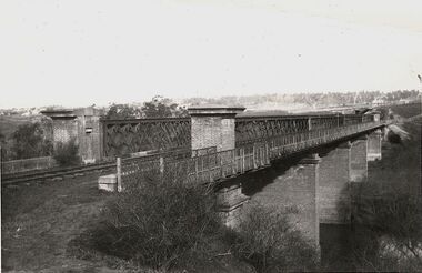
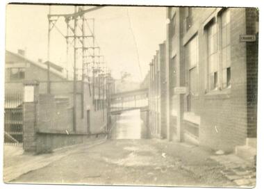
Photograph, Outer Circle Railway Bridge over River Yarra, c.1900
... Outer Circle Railway Bridge over River Yarra...The bridge has a cantilevered walkway along the west side. ...The Chandler Highway Bridge crosses the Yarra River and connects Alphington and Kew. ...Black & white photograph of the railway viaduct over Yarra River looking south towards Kew....Outer Circle Railway Bridge over River Yarra (now Chandler Highway) - note bridge over line on Kew side for Asylum Farm". ...Black & white photograph of the railway viaduct over Yarra River looking south towards Kew. Outer Circle Railway Bridge over River Yarra Photograph Photograph ...This photograph forms part of the Eric Sibly collection of images and information relating to the Outer Circle Railway which he donated to the Kew Historical Society in 1974. Heritage Victoria Citation (Abridged) "The Chandler Highway Bridge, a 137 metre wrought iron lattice-truss girder bridge with four spans supported on red brick piers with moulded bluestone cappings. The bridge has a cantilevered walkway along the west side. ...The Chandler Highway Bridge crosses the Yarra River and connects Alphington and Kew. It was completed in November 1890 as part of the Outer Circle Railway Line.Black & white photograph of the railway viaduct over Yarra River looking south towards Kew.Reverse: "Pre 1930. Outer Circle Railway Bridge over River Yarra (now Chandler Highway) - note bridge over line on Kew side for Asylum Farm". KH - 56. Kew Historical Society.chandler highway, railway bridges - kew (vic), sir john monash, outer circle railway, river yarra - kew (vic) -
 Kew Historical Society Inc
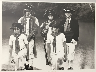
Photograph, Standard Newspapers, Charles Grimes Re-enactment, Yarra River, 1978
... Charles Grimes Re-enactment, Yarra River...The party of the British surveyor Charles Grimes were the first Europeans to view the River Yarra, as it was later to be named. Members of the party reached the area now known as Studley Park in 1803. ...Charles Grimes, Re-enactment, Yarra River, Kew, 1978. ...Inscription on reverse: "Trinity Grammar School students taking part in Grimes' journey up the Yarra, 1803. Re-enactment Historical Society Kew contribution to the 1978 Festival of Kew."...Charles Grimes, Re-enactment, Yarra River, Kew, 1978. Charles Grimes Re-enactment, Yarra River Photograph Photograph Standard Newspapers ...The party of the British surveyor Charles Grimes were the first Europeans to view the River Yarra, as it was later to be named. Members of the party reached the area now known as Studley Park in 1803. This local re-enactment commemorated 175 years since that event.Charles Grimes, Re-enactment, Yarra River, Kew, 1978. Inscription on reverse: "Trinity Grammar School students taking part in Grimes' journey up the Yarra, 1803. Re-enactment Historical Society Kew contribution to the 1978 Festival of Kew."charles grimes re-enactment, trinity grammar school, cr whiting -- mayors -- kew (vic.), yarra river, andrew allen, kew historical society -
 Kew Historical Society Inc
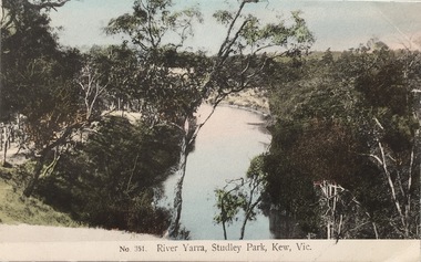
Postcard, The VSM.Series, No.351. River Yarra, Studley Park, Kew, Vic, c.1905
... No.351. River Yarra, Studley Park, Kew, Vic....This is a colour postcard of the River Yarra at Studley Park, circa 1905. The postcard, which has handwritten notes on the reverse. ...Coloured postcard of the Yarra River looking north from Galatea Point, near the Johnson Street Bridge....Identified by Darcy Dugan, Yarra Bend Parks....No.351. River Yarra, Studley Park, Kew, Vic. Postcard Postcard The VSM.Series ...This is a colour postcard of the River Yarra at Studley Park, circa 1905. The postcard, which has handwritten notes on the reverse. It was printed in Prussia as part of the Victoria Stamp Market (VSM) Series. Coloured postcard of the Yarra River looking north from Galatea Point, near the Johnson Street Bridge.Donated by Miss B. Challen. ?Taken from bend above Galatea Point, looking north. Identified by Darcy Dugan, Yarra Bend Parks.river yarra, victoria stamp market (vsm) series, postcards -
 Kew Historical Society Inc
Photograph, Standard Newspapers, Charles Grimes Re-enactment, Yarra River, 1978
... Charles Grimes Re-enactment, Yarra River...The party of the British surveyor Charles Grimes were the first Europeans to view the River Yarra, as it was later to be named. Members of the party reached the area now known as Studley Park in 1803. ...Charles Grimes Re-Enactment, Yarra River, Kew, 1978. The photograph is of a student of Trinity Grammar School and the Mayor of Kew, Cr. ...Re-enactment of first white man's journey and discovery of the Yarra River and the area now know (sic) as Kew. 1978. ...Charles Grimes Re-enactment, Yarra River Photograph Photograph Standard Newspapers ...The party of the British surveyor Charles Grimes were the first Europeans to view the River Yarra, as it was later to be named. Members of the party reached the area now known as Studley Park in 1803. This local re-enactment commemorated 175 years since that event. Charles Grimes Re-Enactment, Yarra River, Kew, 1978. The photograph is of a student of Trinity Grammar School and the Mayor of Kew, Cr. Whiting. Inscription on reverse: "KH-161. Society's contribution to the 1978 Festival of Kew. Re-enactment of first white man's journey and discovery of the Yarra River and the area now know (sic) as Kew. 1978. This was in the year 1903 when Grimes and party came upon the Yarra to seek a possible site for a new convict settlement. Cr. Whiting, Mayor of Kew, receiving the report from Grimes, 'Andrew Allen'. Cr. Hutchinson in top hat 'town cryer'. Bush band in backround." Ripped stamp on reverse: "Standard N[ewspapers]."charles grimes re-enactment, trinity grammar school, cr whiting -- mayors -- kew (vic.), yarra river, andrew allen, kew historical society -
 Kew Historical Society Inc
Photograph, Standard Newspapers, Charles Grimes Re-enactment, Yarra River, 1978
... Charles Grimes Re-enactment, Yarra River...The party of the British surveyor Charles Grimes were the first Europeans to view the River Yarra, as it was later to be named. Members of the party reached the area now known as Studley Park in 1803. ...Charles Grimes, Re-enactment, Yarra River, Kew, 1978. ...Grimes' party in boat on Yarra 1978. Re-enactment organised by Kew Historical Society. ...Charles Grimes, Re-enactment, Yarra River, Kew, 1978. Charles Grimes Re-enactment, Yarra River Photograph Photograph Standard Newspapers ...The party of the British surveyor Charles Grimes were the first Europeans to view the River Yarra, as it was later to be named. Members of the party reached the area now known as Studley Park in 1803. This local re-enactment commemorated 175 years since that event.Charles Grimes, Re-enactment, Yarra River, Kew, 1978. Inscription on reverse: "KH-191. Grimes' party in boat on Yarra 1978. Re-enactment organised by Kew Historical Society. Actors Trinity Grammar boys. Mrs Argyle's History class." Sticker on back: "771. Standard News. WHS. Festival. 4 cols. May 3. [Page] 5."charles grimes re-enactment, yarra river (kew) 1978, cr whiting (mayor of kew), andrew allen, trinity grammar school, kew historical society -
 Kew Historical Society Inc
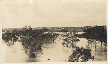
Photograph, Marnie McLeod, Floods on the River Yarra at Kew, 1916
... Floods on the River Yarra at Kew...Laver's residence, where they themselves have been given accommodation in the meantime. All the river flats in East Kew are under water. One or two low-lying houses have been flooded. ...Panoramic view, believed to be looking north towards Fairfield from the Zig-Zag Bridge on the River Yarra. The inscription on the reverese identifies it as taken before 1920....Inscription on reverse in ink "(pre 1920) Flood from Zig-zag bridge Yarra River, Kew Vic."...Floods on the River Yarra at Kew Photograph Photograph Marnie McLeod ...The donation was accompanied by the following letter from the donor: "Hi. I found these in with family photos. Taken by family as Mamie McLeod was living in Fellows Street, Kew, so would be near there. Retain (or discard) as you see fit." [Donor's name and address withheld from public view]. To gain an insight into the flood levels at Kew, it is worth reading newspaper accounts of the event. The Age published an article - Valuable Gardens Destroyed at Kew - on 25 September 1916: "VALUABLE GARDENS DESTROYED AT KEW. From the heights of Studley Park, Kew, a splendid view of the flood waters can be obtained, and yesterday afternoon, despite continuous rain, crowds of citizens assembled there to witness the spectacle. There is a vast stretch of water some 300 or 400 yards broad, above the foot bridge connecting Gipps-street, Collingwood, and Studley Park. The river is only about 3 feet from the top of the embankment connecting with the ramp of the bridge on the Studiey Park side. When the upper llood waters come down it is almost a certainty that tne embankment will be submerged and the bridge rendered impassible. Below the bridge the waters again stretch out, and have submerged all the low-lying land on the Collingwood side and invaded the back premises ot the Kodak Co., Phoenix Biscuit Factory, a tannery adjoining thereto, the Shamrock Brewery, and Chinese gardens in the vicinity. At Walmer-street-bridge, at the end of Studley Park, the low-lying land on the Kew side is covered with water to the depth of many feet. Tlie land in question is owned in a great part by Mr Frank Lavers who haa gone in for intense culture on a pretty liberal scale on both the slopes of the hill and on the river flat. On the latter he is cultivating many acres of asparagus, and has at a considerable cost spent three years in preparing the ground and installing an irrigation system, reticulated from the Yan Yean water supply. This year the asparagus was put down, and the plants were in a promising condition. Tlie flood waters are now flowing fast over the land. The crop is ruined, and three years' work and expenditure destroyed. Mr. Laver's private residence fortunately is high above flood level, but two houses he owns off Young-street have been flooded out. Having been warned in time, the tenants removed their furniture hefore the water came down to Mr. Laver's residence, where they themselves have been given accommodation in the meantime. All the river flats in East Kew are under water. One or two low-lying houses have been flooded. Chipperfield's boat shed at Willsmere is nearly covered, and some Chinese gardens in the vicinity are several feet under water."This, and the other three photographs donated of floods in Kew are believed to be the earliest in the collection. Together with our original MMBW River Yarra map showing flood levels, these items, when compared allow researchers to gain a visual perspective of the extent of the flood in 1916. Panoramic view, believed to be looking north towards Fairfield from the Zig-Zag Bridge on the River Yarra. The inscription on the reverese identifies it as taken before 1920.Inscription on reverse in ink "(pre 1920) Flood from Zig-zag bridge Yarra River, Kew Vic."river yarra, kew, floods 1916, zig-zag bridge -
 Eltham District Historical Society Inc
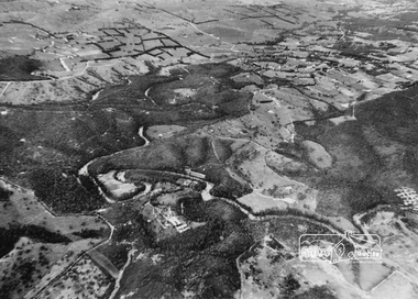
Photograph, Aerial view of Yarra River near Kangaroo Ground - Bend of Islands area
... Aerial view of Yarra River near Kangaroo Ground - Bend of Islands area...Aerial view of Yarra river at Bend of Islands; Henley Road on left in foreground...Sepia aerial view of Yarra river at Bend of Islands; Henley Road on left in foreground...Aerial view of Yarra river at Bend of Islands; Henley Road on left in foreground bend of isles kangaroo ground yarra river henley road Sepia aerial view of Yarra river at Bend of Islands; Henley Road on left in foreground Aerial view of Yarra River near Kangaroo Ground - Bend of Islands area Photograph ...Aerial view of Yarra river at Bend of Islands; Henley Road on left in foregroundSepia aerial view of Yarra river at Bend of Islands; Henley Road on left in foregroundbend of isles, kangaroo ground, yarra river, henley road -
 National Wool Museum
Photograph, Yarra Falls: Yarra River in Flood
... Yarra Falls: Yarra River in Flood...James Murgatroyd worked at Warrnambool Woollen Mills, Federal Mill, Tweedside, Collins Mills and set up looms for Alexander Spinning Mills Sydney, his son Fred Murgatroyd worked as a loom tuner at Yarra Falls, Tweedside and Collins mills in Victoria as well as in Sydney, and studied at Leeds University....F Murgatroyd Yarra Falls: Yarra River in Flood KODAK PRINT...Textile Machinery Textile Mills Textile Mills Yarra Falls Mill Murgatroyd Mr Fred Murgatroyd Mr James Textile Machinery Textile Mills F Murgatroyd Yarra Falls: Yarra River in Flood KODAK PRINT Murgatroyd Photograph Collection Yarra Falls: Yarra River in Flood Photograph ...James Murgatroyd worked at Warrnambool Woollen Mills, Federal Mill, Tweedside, Collins Mills and set up looms for Alexander Spinning Mills Sydney, his son Fred Murgatroyd worked as a loom tuner at Yarra Falls, Tweedside and Collins mills in Victoria as well as in Sydney, and studied at Leeds University.Murgatroyd Photograph CollectionF Murgatroyd Yarra Falls: Yarra River in Flood KODAK PRINTtextile machinery textile mills textile mills, yarra falls mill, murgatroyd, mr fred murgatroyd, mr james, textile machinery, textile mills -
 Lakes Entrance Historical Society
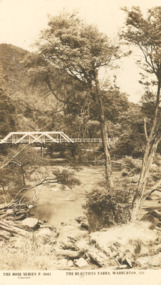
Photograph - Post card Rose series 3643 Warburton, Rose Stereographers Armadale Victoria, Yarra River, Warburton Victoria, 1920 - 30 c
... Yarra River, Warburton Victoria...Sepia toned postcard showing white wooden bridge over Yarra River with hill at back densely wooded shrubbery along river bank and rocky foreground at Warburton Victoria...The Rose Series P3643 The Beautiful Yarra Warburton Victoria...Lakes Entrance Historical Society 4 Marine Parade Lakes Entrance gippsland The writer of the message on back of card was a Miss Ruth Catt who boarded with the family of Vic and Myrtle Fish of Roadknight St Lakes Entrance in the 1920 - 30 She was a teacher at the Bunga Creek State School East of Lakes Entrance and walked through the bush to school School teachers Correspondence The Rose Series P3643 The Beautiful Yarra Warburton Victoria Sepia toned postcard showing white wooden bridge over Yarra River with hill at back densely wooded shrubbery along river bank and rocky foreground at Warburton Victoria Yarra River, Warburton Victoria Photograph Post card Rose series 3643 Warburton Rose Stereographers Armadale Victoria ...The writer of the message on back of card was a Miss Ruth Catt who boarded with the family of Vic and Myrtle Fish of Roadknight St Lakes Entrance in the 1920 - 30 She was a teacher at the Bunga Creek State School East of Lakes Entrance and walked through the bush to schoolSepia toned postcard showing white wooden bridge over Yarra River with hill at back densely wooded shrubbery along river bank and rocky foreground at Warburton VictoriaThe Rose Series P3643 The Beautiful Yarra Warburton Victoriaschool teachers, correspondence -
 Queenscliffe Maritime Museum
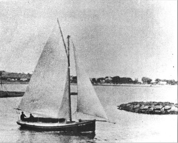
photograph - Photo of Couta boat COOMA on the Yarra River, COOMA on the Yarra River, 1986
... COOMA on the Yarra River...Black & white photo of the Couta boat COOMA on the Yarra River c1911...Reverse - " COOMA fishing boat / built PEEL Melbourne 1911 / for George Jurgens / photo: sailing out of Yarra R after taking delivery "...Queenscliffe Maritime Museum 2 Wharf St Queenscliff geelong-and-the-bellarine-peninsula Couta boats historical references Reverse - " COOMA fishing boat / built PEEL Melbourne 1911 / for George Jurgens / photo: sailing out of Yarra R after taking delivery " Black & white photo of the Couta boat COOMA on the Yarra River c1911 COOMA on the Yarra River photograph Photo of Couta boat COOMA on the Yarra River ...Couta boatsBlack & white photo of the Couta boat COOMA on the Yarra River c1911Reverse - " COOMA fishing boat / built PEEL Melbourne 1911 / for George Jurgens / photo: sailing out of Yarra R after taking delivery "historical references -
 Kew Historical Society Inc
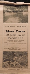
Flyer, Melbourne Ferries Pty Ltd, River Yarra: 20 Miles Scenic Wonder Trip
... River Yarra: 20 Miles Scenic Wonder Trip...Harding's (aka Melbourne Ferries Pty Ltd) ran boat cruises on the River Yarra. The tourist trip passed a number of ‘beauty spots’ along the river between Princes Bridge and Heidelberg via Studley Park. ...Flyer for Harding’s Launches on the River Yarra: 20 miles scenic wonder trip. Aerial view over Dight’s Falls on front. ...River Yarra: 20 Miles Scenic Wonder Trip Flyer Melbourne Ferries Pty Ltd ...Bifold brochure including route map of the full 44 mile 'Wonder Trip' on pages 2 & 3. Photos used include an 'Aerial view over Dight's Falls', two ferries, and a 'Scene near Dight's Falls'.Flyer for Harding’s Launches on the River Yarra: 20 miles scenic wonder trip. Aerial view over Dight’s Falls on front. non-fictionBifold brochure including route map of the full 44 mile 'Wonder Trip' on pages 2 & 3. Photos used include an 'Aerial view over Dight's Falls', two ferries, and a 'Scene near Dight's Falls'.river yarra, melbourne ferries pty ltd, yarra river -- tourism, harding's cruises, christian-washfold collection -
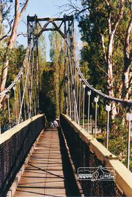 Eltham District Historical Society Inc
Photograph, Pedestrian suspension bridge over the Yarra River at Lower Plenty
... Pedestrian suspension bridge over the Yarra River at Lower Plenty...The bridge is now part of the Yarra Trails system....Colour photograph of footbridge over Yarra River, part of the Ruffey Trail just off the Main Yarra Trail near the former seminary (now Odyssey House) Lower Plenty...The bridge is now part of the Yarra Trails system. bridges yarra river lower plenty seminary blessed sacrament fathers odyssey house bonds road Colour photograph of footbridge over Yarra River, part of the Ruffey Trail just off the Main Yarra Trail near the former seminary (now Odyssey House) Lower Plenty Pedestrian suspension bridge over the Yarra River at Lower Plenty Photograph ...Odyssey House drug rehabilitation centre in Bonds Road, Lower Plenty is a distinctive landmark, especially when viewed from across the Yarra at Templestowe. It was built in the 1950’s as a seminary for the Blessed Sacrament Fathers. Because of the poor and circuitous road access, a suspension footbridge was built across the river. As well as providing easy access for the priests residents of Templestowe could attend services at the seminary. The bridge is now part of the Yarra Trails system.Colour photograph of footbridge over Yarra River, part of the Ruffey Trail just off the Main Yarra Trail near the former seminary (now Odyssey House) Lower Plentybridges, yarra river, lower plenty, seminary, blessed sacrament fathers, odyssey house, bonds road -
 Whitehorse Historical Society Inc.
Map, Yarra River, 1839
... Yarra River...Covers area from Templestowe to Yarra Glen....Nott's original survey of 'Yarra Yarra River' taken from 'Lilydale' by Grace Aveling. ...Whitehorse Historical Society Inc. 2-10 Deep Creek Road Mitcham melbourne Covers area from Templestowe to Yarra Glen. Maps Yarra River Copy of T.H. Nott's original survey of 'Yarra Yarra River' taken from 'Lilydale' by Grace Aveling. ...Copy of T.H. Nott's original survey of 'Yarra Yarra River' taken from 'Lilydale' by Grace Aveling.Copy of T.H. Nott's original survey of 'Yarra Yarra River' taken from 'Lilydale' by Grace Aveling. Covers area from Templestowe to Yarra Glen.Copy of T.H. Nott's original survey of 'Yarra Yarra River' taken from 'Lilydale' by Grace Aveling. maps, yarra river -
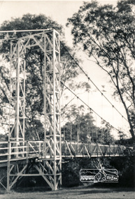 Eltham District Historical Society Inc
Photograph, Pedestrian suspension bridge over the Yarra River at Lower Plenty
... Pedestrian suspension bridge over the Yarra River at Lower Plenty...The bridge is now part of the Yarra Trails system....Two black and white photographs of footbridge over Yarra River, part of the Ruffey Trail just off the Main Yarra Trail near the former seminary (now Odyssey House) Lower Plenty...The bridge is now part of the Yarra Trails system. bridges yarra river odyssey house bonds road lower plenty seminary blessed sacrament fathers Two black and white photographs of footbridge over Yarra River, part of the Ruffey Trail just off the Main Yarra Trail near the former seminary (now Odyssey House) Lower Plenty Pedestrian suspension bridge over the Yarra River at Lower Plenty Photograph ...Odyssey House drug rehabilitation centre in Bonds Road, Lower Plenty is a distinctive landmark, especially when viewed from across the Yarra at Templestowe. It was built in the 1950’s as a seminary for the Blessed Sacrament Fathers. Because of the poor and circuitous road access, a suspension footbridge was built across the river. As well as providing easy access for the priests residents of Templestowe could attend services at the seminary. The bridge is now part of the Yarra Trails system.Two black and white photographs of footbridge over Yarra River, part of the Ruffey Trail just off the Main Yarra Trail near the former seminary (now Odyssey House) Lower Plentybridges, yarra river, odyssey house, bonds road, lower plenty, seminary, blessed sacrament fathers -
 Eltham District Historical Society Inc
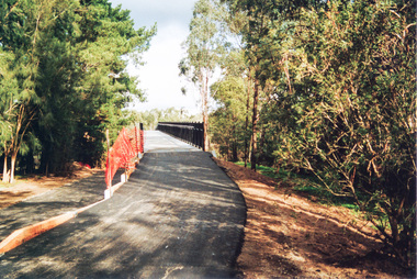
Photograph, Doug Orford, Completion of bridge works across Yarra River at rear of Eltham Lower Park, July 2004
... Completion of bridge works across Yarra River at rear of Eltham Lower Park...It is a shared pathway and also links with the Main Yarra Trail. It affords lovely views over the Yarra River....Three colour photographs showing commencement of construction of Eltham-Templestowe footbridge over Yarra River off Homestead Road, Eltham which was completed July 2004. ...It is a shared pathway and also links with the Main Yarra Trail. It affords lovely views over the Yarra River. bridges yarra river eltham south eltham lower park lenister farm homestead road asphaldt bitumen shared pathway Diamond Creek Trail Three colour photographs showing commencement of construction of Eltham-Templestowe footbridge over Yarra River off Homestead Road, Eltham which was completed July 2004. ...Bitumen shared pathway under construction at the new Eltham-Templestowe footbridge over the Yarra River off Homestead Road, Eltham which was completed in July 2004. The Yarra River Footbridge was opened in August 2004 and links the Diamond Creek Trail between the Shire of Nillumbik and City of Manningham. It is a shared pathway and also links with the Main Yarra Trail. It affords lovely views over the Yarra River.Three colour photographs showing commencement of construction of Eltham-Templestowe footbridge over Yarra River off Homestead Road, Eltham which was completed July 2004. Third photograph of dedictaion plaque at opening 30 Aug 2004bridges, yarra river, eltham south, eltham lower park, lenister farm, homestead road, asphaldt, bitumen, shared pathway, diamond creek trail -
 Kew Historical Society Inc
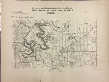
Map, MMBW, River Yarra Beautification Schemes, c.1913
... River Yarra Beautification Schemes...Map of the City of Kew showing part of the River Yarra Beautification Schemes. The map shows development to date and the flood levels reached in 1923 and 1924. ...MELBOURNE AND METROPOLITAN BOARD OF WORKS / RIVER YARRA BEAUTIFICATION SCHEMES / SCHEME / SCALE 10 CHAINS TO AN INCH...As these were working documents, information was added to them long after the period of their initial production and distribution. melbourne & metropolitan board of works mmbw maps mmbw plans city of kew flood levels -- kew (vic.) cartography MELBOURNE AND METROPOLITAN BOARD OF WORKS / RIVER YARRA BEAUTIFICATION SCHEMES / SCHEME / SCALE 10 CHAINS TO AN INCH Map of the City of Kew showing part of the River Yarra Beautification Schemes. ...The Melbourne and Metropolitan Board of Works (MMBW) was established by an act of the Victorian Parliament in 1890 to prepare for and to implement a sewerage and water reticulation system across what was then inner Melbourne, its surrounding and middle distance suburbs, including Kew. The MMBW was disbanded in 1991.The map collection of the Kew Historical Society has at its core the historic maps assembled and originally stored in the City Engineer's Department of the City of Kew. These include maps in a number of scales. The vast majority of maps were produced by the MMBW in the first two decades of the twentieth century, and are solid working maps, backed by linen for durability. These maps are historically significant to Kew, the City of Boroondara and to the history of the development of state utilities in Victoria. A number of the Kew maps have additional details added by former municipal officers, including the levels reached by various floods. As these were working documents, information was added to them long after the period of their initial production and distribution.Map of the City of Kew showing part of the River Yarra Beautification Schemes. The map shows development to date and the flood levels reached in 1923 and 1924. This map may have been adapted from an earlier map, as most development in central Kew and Studley Park had occurred by this date yet numerous streets are not represented. Public buildings and institutions are clearly represented and named on the map as are significant public transport infrastructure (eg the Outer Circle railway).MELBOURNE AND METROPOLITAN BOARD OF WORKS / RIVER YARRA BEAUTIFICATION SCHEMES / SCHEME / SCALE 10 CHAINS TO AN INCHmelbourne & metropolitan board of works, mmbw maps, mmbw plans, city of kew, flood levels -- kew (vic.), cartography -
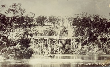 Kew Historical Society Inc
Postcard, J.W.K. & Co, River Yarra near Macauleys' Boathouse Kew, c.1910
... River Yarra near Macauleys' Boathouse Kew...The Zig-Zag Bridge which was constructed in the 1870s to link the Yarra Bend Asylum and Kew Asylum. Initially it transported bluestone from the west side of the Yarra to the east during the construction of the Kew Asylum....Obverse: "River Yarra near Macauleys' Boathouse Kew". ...Bridges -- river yarra bridges - kew (vic.) zig-zag bridge Obverse: "River Yarra near Macauleys' Boathouse Kew". ...The Zig-Zag Bridge which was constructed in the 1870s to link the Yarra Bend Asylum and Kew Asylum. Initially it transported bluestone from the west side of the Yarra to the east during the construction of the Kew Asylum.Real photo postcard of the Zig-Zag Bridge at Kew. In the middle ground there is a rowboat.Obverse: "River Yarra near Macauleys' Boathouse Kew". Reverse: "Gift from L Bennett"bridges -- river yarra, bridges - kew (vic.), zig-zag bridge -
 Kew Historical Society Inc
Print, View on the Yarra Near Dights Falls, Nineteenth Century
... View on the Yarra Near Dights Falls...The original book plate reflects the colonial use of the River Yarra fro both recreation and industry....View on the Yarra Near Dights Falls. Reproduction of a book plate from an original wood engravingg, showing men and boys on the banks of the River Yarra. ...Annotation on reverse: [Original] "Caption: View on the Yarra Near Dights Falls."...Kew Historical Society Inc Kew Court House 188 High Street Kew melbourne The original book plate reflects the colonial use of the River Yarra fro both recreation and industry. yarra river dights falls Annotation on reverse: [Original] "Caption: View on the Yarra Near Dights Falls." ...The original book plate reflects the colonial use of the River Yarra fro both recreation and industry.View on the Yarra Near Dights Falls. Reproduction of a book plate from an original wood engravingg, showing men and boys on the banks of the River Yarra. The activities represented include logging and fishing. Annotation on reverse: [Original] "Caption: View on the Yarra Near Dights Falls."yarra river, dights falls -
 Ballarat Heritage Services
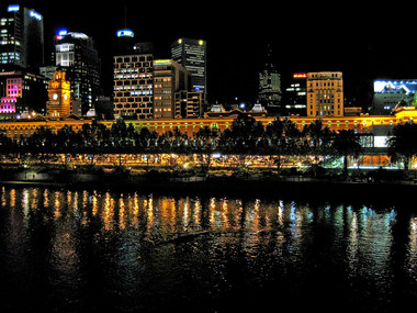
Digital photographs, L.J. Gervasoni, Yarra River rowing at night, c2011
... Yarra River rowing at night...Yarra River, Melbourne, Victoria, Australia...Ballarat Heritage Services PO Box 2209 Bakery Hill Post Office goldfields Yarra River Flinders Street CBD night rowing Melbourne Yarra River rowing at night Digital photographs L.J. ...yarra river, flinders street, cbd, night, rowing, melbourne -
 Ballarat Heritage Services
Digital photographs, birds Yarra River Melbourne Docklands, 2015
... birds Yarra River Melbourne Docklands...Yarra River Melbourne Docklands, Melbourne, VIC, Australia...Ballarat Heritage Services PO Box 2209 Bakery Hill Post Office goldfields yarra river melbourne docklands yarra river dock docklands shipping port channel birds water Digital Images birds Yarra River Melbourne Docklands Digital photographs L.J. ...Digital Imagesyarra river melbourne docklands, yarra river, dock, docklands, shipping, port, channel, birds, water -
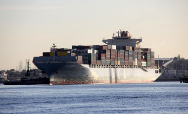 Ballarat Heritage Services
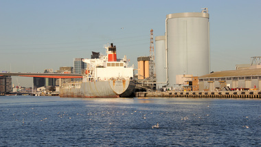
Digital photographs, L.J. Gervasoni, Yarra River Melbourne Docklands MOL Earnest container ship, 2015
... Yarra River Melbourne Docklands MOL Earnest container ship...Yarra River Melbourne Docklands, Melbourne, Victoria, Australia...Ballarat Heritage Services PO Box 2209 Bakery Hill Post Office goldfields yarra river melbourne docklands yarra river dock docklands shipping port channel water MOL Earnest Digital Images Yarra River Melbourne Docklands MOL Earnest container ship Digital photographs L.J. ...Digital Imagesyarra river melbourne docklands, yarra river, dock, docklands, shipping, port, channel, water, mol, earnest -
 Ballarat Heritage Services
Digital photographs, L.J. Gervasoni, Yarra River Melbourne Docklands Westgate Bridge, 2015
... Yarra River Melbourne Docklands Westgate Bridge...Yarra River Melbourne Docklands, Melbourne, Victoria, Australia...Ballarat Heritage Services PO Box 2209 Bakery Hill Post Office goldfields yarra river melbourne docklands yarra river dock docklands shipping port channel water West Gate Bridge bridge Digital Images Yarra River Melbourne Docklands Westgate Bridge Digital photographs L.J. ...Digital Imagesyarra river melbourne docklands, yarra river, dock, docklands, shipping, port, channel, water, west gate bridge, bridge -
 Ballarat Heritage Services
Digital photographs, L.J. Gervasoni, Yarra River Melbourne Docklands Victoria Dock, 2015
... Yarra River Melbourne Docklands Victoria Dock...Yarra River Melbourne Docklands, Melbourne, Victoria, Australia...Ballarat Heritage Services PO Box 2209 Bakery Hill Post Office goldfields yarra river melbourne docklands yarra river dock docklands shipping port channel water victoria dock Digital Images Yarra River Melbourne Docklands Victoria Dock Digital photographs L.J. ...Digital Imagesyarra river melbourne docklands, yarra river, dock, docklands, shipping, port, channel, water, victoria dock -
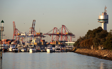 Ballarat Heritage Services
Digital photographs, L.J. Gervasoni, Yarra River Melbourne Docklands container dock cranes, 2015
... Yarra River Melbourne Docklands container dock cranes...Yarra River Melbourne Docklands, Melbourne, Victoria, Australia...Ballarat Heritage Services PO Box 2209 Bakery Hill Post Office goldfields yarra river melbourne docklands yarra river dock docklands shipping port channel water container cranes Digital Images Yarra River Melbourne Docklands container dock cranes Digital photographs L.J. ...Digital Imagesyarra river melbourne docklands, yarra river, dock, docklands, shipping, port, channel, water, container, cranes