Showing 13 items matching "yarrambat - maps"
-
 Greensborough Historical Society
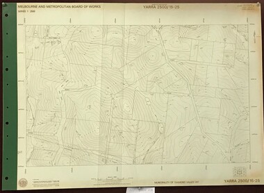
Map, Melbourne and Metropolitan Board of Works. Survey Division, MMBW, Yarra 2500 / 15.25. Yarrambat, Black Gully Road, 1978_07
... ...yarrambat - maps...Yarra 2500 [base map] 15.25. Yarrambat, Black Gully Road. Municipality of Diamond Valley 257. ...Yarra 2500 [base map] 15.25. Yarrambat, Black Gully Road. Municipality of Diamond Valley 257. ...Melbourne and Metropolitan Board of Works. Yarra 2500 [base map] 15.25. Yarrambat, Black Gully Road. Municipality of Diamond Valley 257. Prominent streets include: Black Gully Road, Ironbark Road and Murray Road. MMBW Map in 1:2500 [scale] series. Cream parchment with green tape reinforcing on edges and punched holes on left edge.mmbw, melbourne and metropolitan board of works, shire of diamond valley, yarrambat - maps -
 Greensborough Historical Society
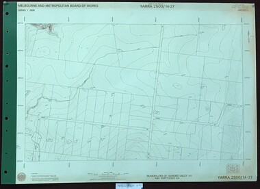
Map, Melbourne and Metropolitan Board of Works. Survey Division, MMBW, Yarra 2500 / 14.27. Yarrambat, Youngs Road, 1977_09
... ...yarrambat - maps...Yarra 2500 [base map] 14.27. Yarrambat, Youngs Road. Municipalities of Diamond Valley 257 and Whittlesea 239. ...MMBW, Yarra 2500 / 14.27. Yarrambat, Youngs Road. Map Map Melbourne and Metropolitan Board of Works. ...Melbourne and Metropolitan Board of Works. Yarra 2500 [base map] 14.27. Yarrambat, Youngs Road. Municipalities of Diamond Valley 257 and Whittlesea 239. Prominent streets include: Youngs Road, Ashley Road and Yan Yean Road. MMBW Map in 1:2500 [scale] series. Cream parchment with green tape reinforcing on edges and punched holes on left edge.mmbw, melbourne and metropolitan board of works, shire of diamond valley, whttlesea, yarrambat - maps -
 Greensborough Historical Society
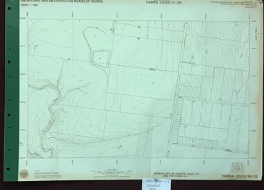
Map, Melbourne and Metropolitan Board of Works. Survey Division, MMBW, Yarra 2500 / 14.28. Yarrambat Park, 1977_09
... ...yarrambat - maps...Yarra 2500 [base map] 14.28. Yarrambat Park. Municipalities of Diamond Valley 257 and Whittlesea 239. ...MMBW, Yarra 2500 / 14.28. Yarrambat Park. Map Map Melbourne and Metropolitan Board of Works. ...Melbourne and Metropolitan Board of Works. Yarra 2500 [base map] 14.28. Yarrambat Park. Municipalities of Diamond Valley 257 and Whittlesea 239. Prominent streets include: Bannons Road and Yan Yean Road. Features include the Plenty River.MMBW Map in 1:2500 [scale] series. Cream parchment with green tape reinforcing on edges and punched holes on left edge.mmbw, melbourne and metropolitan board of works, shire of diamond valley, whttlesea, yarrambat - maps -
 Greensborough Historical Society
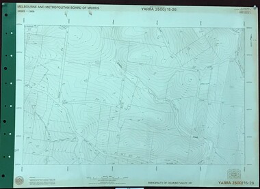
Map, Melbourne and Metropolitan Board of Works. Survey Division, MMBW, Yarra 2500 / 15.26. Yarrambat, Hacketts Road, 1978_07
... ...yarrambat - maps...Yarra 2500 [base map] 15.26. Yarrambat, Hacketts Road. Municipality of Diamond Valley 257. ...MMBW, Yarra 2500 / 15.26. Yarrambat, Hacketts Road. Map Map Melbourne and Metropolitan Board of Works. ...Melbourne and Metropolitan Board of Works. Yarra 2500 [base map] 15.26. Yarrambat, Hacketts Road. Municipality of Diamond Valley 257. Prominent streets include: Black Gully Road, Hacketts Road and Collins Lane. Features include Scrubby Creek.MMBW Map in 1:2500 [scale] series. Cream parchment with green tape reinforcing on edges and punched holes on left edge.mmbw, melbourne and metropolitan board of works, shire of diamond valley, yarrambat - maps -
 Greensborough Historical Society
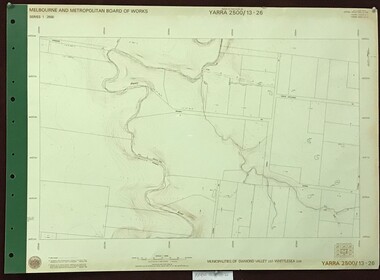
Map, Melbourne and Metropolitan Board of Works. Survey Division, MMBW, Yarra 2500 / 13.26. Yarrambat, Worns Lane, 1978_02
... ...yarrambat - maps...Yarra 2500 [base map] 13.26. Yarrambat, Worns Lane. Municipalities of Diamond Valley 257 and Whittlesea 239. ...MMBW, Yarra 2500 / 13.26. Yarrambat, Worns Lane. Map Map Melbourne and Metropolitan Board of Works. ...Melbourne and Metropolitan Board of Works. Yarra 2500 [base map] 13.26. Yarrambat, Worns Lane. Municipalities of Diamond Valley 257 and Whittlesea 239. Prominent streets include: Worns Road, North Oatlands Road and Licola Street. Features include Plenty River.MMBW Map in 1:2500 [scale] series. Cream parchment with green tape reinforcing on edges and punched holes on left edge.mmbw, melbourne and metropolitan board of works, shire of diamond valley, whttlesea, yarrambat - maps -
 Greensborough Historical Society
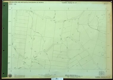
Map, Melbourne and Metropolitan Board of Works. Survey Division, MMBW, Yarra 2500 / 15.27. Yarrambat, De Fredricks Lane, 1977_10
... ...yarrambat - maps...Yarra 2500 [base map] 15.27. Yarrambat, De Fredricks Lane. Parish of Greensborough 2724. ...Yarra 2500 [base map] 15.27. Yarrambat, De Fredricks Lane. Parish of Greensborough 2724. ...Melbourne and Metropolitan Board of Works. Yarra 2500 [base map] 15.27. Yarrambat, De Fredricks Lane. Parish of Greensborough 2724. Municipality of Diamond Valley 257 and Whittlesea 239. Prominent streets include: De Fredricks Lane, Astons Road and Bannons Lane. Features include Scrubby Creek.MMBW Map in 1:2500 [scale] series. Cream parchment with green tape reinforcing on edges and punched holes on left edge.mmbw, melbourne and metropolitan board of works, shire of diamond valley, yarrambat - maps -
 Greensborough Historical Society
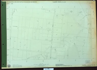
Map, Melbourne and Metropolitan Board of Works. Survey Division, MMBW, Yarra 2500 / 14.27. Yarrambat, Yan Yean Road, 1978_04
... ...yarrambat - maps...Yarra 2500 [base map] 14.26. Yarrambat, Yan Yean Road. Parishes of Morang 3183 and Greensborough 2724. ...Yarra 2500 [base map] 14.26. Yarrambat, Yan Yean Road. Parishes of Morang 3183 and Greensborough 2724. ...Melbourne and Metropolitan Board of Works. Yarra 2500 [base map] 14.26. Yarrambat, Yan Yean Road. Parishes of Morang 3183 and Greensborough 2724. Municipality of Diamond Valley 257. Prominent streets include: Yan Yean Road, North Oatlands Road and Pioneer Road. Features include Yarrambat War Memorial Reserve.MMBW Map in 1:2500 [scale] series. Cream parchment with green tape reinforcing on edges and punched holes on left edge.mmbw, melbourne and metropolitan board of works, shire of diamond valley, whttlesea, yarrambat - maps -
 Greensborough Historical Society
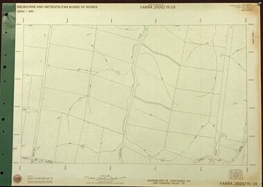
Map, Melbourne and Metropolitan Board of Works. Survey Division, MMBW, Yarra 2500 / 15.28. Yarrambat, 1977_10
... ...yarrambat - maps...Yarra 2500 [base map] 15-28. Yarrambat. Municipalities of Diamond Valley 257 and Whittlesea 239. ...MMBW, Yarra 2500 / 15.28. Yarrambat. Map Map Melbourne and Metropolitan Board of Works. ...Melbourne and Metropolitan Board of Works. Yarra 2500 [base map] 15-28. Yarrambat. Municipalities of Diamond Valley 257 and Whittlesea 239. Prominent streets include: Edward Henty Avenue, Charles Sturt Drive and Creighton Way. MMBW Map in 1:2500 [scale] series. Cream parchment with green tape reinforcing on edges and punched holes on left edge.mmbw, melbourne and metropolitan board of works, shire of diamond valley, yarrambat - maps -
 Eltham District Historical Society Inc
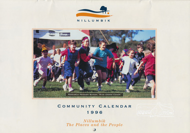
Calendar, Nillumbik Community Calendar 1996: Nillumbik The Places and the People, 1995
... diamond creek trail,yarrambat golf course,sugar loaf reservoir,map...One of a series of calendars which the Shire of Eltham and the Shire of Nillumbik published annually Photography by Graham Hosking Photography. calendar,1996,shire of nillumbik,research primary school,eltham north adventure playground,edendale gateway,tony trembath,eltham leisure centre,diamond valley railway,kangaroo ground pony club,eltham community and reception centre,eltham community centre,shire of nillumbik,swimming pool,yarra river, diamond creek trail,yarrambat golf course,sugar loaf reservoir,map Monthly calendar printed in landscape mode, with feature photograph and template of dates for each of the 12 months presented. ...Community Project. One of a series of calendars which the Shire of Eltham and the Shire of Nillumbik published annually Photography by Graham Hosking Photography. Monthly calendar printed in landscape mode, with feature photograph and template of dates for each of the 12 months presented. Includes advertisements. Back of the calendar includes a list of emergency numbers.calendar,1996,shire of nillumbik,research primary school,eltham north adventure playground,edendale gateway,tony trembath,eltham leisure centre,diamond valley railway,kangaroo ground pony club,eltham community and reception centre,eltham community centre,shire of nillumbik,swimming pool,yarra river,, diamond creek trail,yarrambat golf course,sugar loaf reservoir,map -
 Greensborough Historical Society
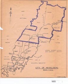
Map, City of Heidelberg, City of Heidelberg, 1962, 02/02/1962
... Map of City of Heidelberg showing boundaries of its six wards; North Ward is highlighted, covering Watsonia, Greensborough, part Bundoora, St Helena, Plenty, Yarrambat and Diamond Creek....Greensborough Historical Society 34A Glenauburn Road Lower Plenty Lower Plenty melbourne Map of City of Heidelberg showing boundaries of its six wards; North Ward is highlighted, covering Watsonia, Greensborough, part Bundoora, St Helena, Plenty, Yarrambat and Diamond Creek. city of heidelberg heidelberg - maps City of Heidelberg Scale: 1" to 1 ml. ...Map of City of Heidelberg showing boundaries of its six wards; North Ward is highlighted, covering Watsonia, Greensborough, part Bundoora, St Helena, Plenty, Yarrambat and Diamond Creek.Blue print mapCity of Heidelberg Scale: 1" to 1 ml. G.M.H. 2.2.62city of heidelberg, heidelberg - maps -
 Greensborough Historical Society
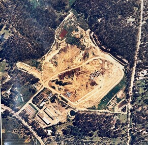
Map - Aerial Photograph, Yarrambat, 04/11/1986
... Scale approx. 1:1000 Yarrambat Map Aerial Photograph ...Colour aerial photograph of Diamond Valley Shire Depot, Yarrambat, now Nillumbik Shire Council Works Depot & Recycling CentreColour aerial photograph. Scale approx. 1:1000shire of diamond valley, yarrambat, nillumbik council -
 Greensborough Historical Society
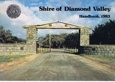
Book, Shire of Diamond Valley Handbook 1983, 1983_
... maps. Cover illustration of the bluestone gateway, main entrance to Yarrambat Park, opened 1982....maps. Cover illustration of the bluestone gateway, main entrance to Yarrambat Park, opened 1982. ...Guide to services provided by Shire of Diamond Valley. The Shire of Diamond Valley was a Local Government Area located about 20 kilometres northeast of Melbourne. The shire covered an area of 74.38 square kilometres and existed from 1964 until 1994.Annual guide to services in Shire of Diamond Valley32 pages, col illus., maps. Cover illustration of the bluestone gateway, main entrance to Yarrambat Park, opened 1982.shire of diamond valley, greensborough, handbooks -
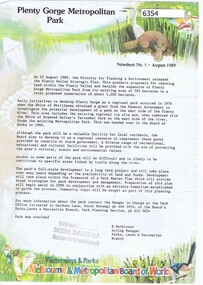 Greensborough Historical Society
Newsletter, Plenty Gorge Metropolitan Park Newsheet No. 1 August 1989, 1989_08
... Yarrambat Park were handed over to the MMBW to form the existing Metropolitan Park in 1986. A long term project to develop the park further is to commence in 1990. plenty gorge park plenty river shire of whittlesea "With compliments of Sherryl Garbutt M.P. Member for Greensborough" (rubber stamp) 2 p. text, map ...The Shire of Whittlesea obtained a grant from the federal government to investigate the potential development of a park to the west of the Plenty River in 1976. A regional tip site and the Shire of Diamond Valley's Yarrambat Park were handed over to the MMBW to form the existing Metropolitan Park in 1986. A long term project to develop the park further is to commence in 1990.2 p. text, map and col. illus."With compliments of Sherryl Garbutt M.P. Member for Greensborough" (rubber stamp)plenty gorge park, plenty river, shire of whittlesea