-
 Hume City Civic Collection
Map, Sunbury Township 1857
This is a reprint of a 1857 map of the township of Sunbury in the County of Bourke produced by the Public Records Office by courtesy of the Surveyor General in 1978.This is a reprint of a 1857 map of the township of Sunbury.sunbury, shire of bulla, sunbury township, 1850s -
Whitehorse Historical Society Inc.
Map, City of Nunawading, 1970
Map showing flats of high, medium low and restricted low density, adopted by Council in June 1969.Map showing flats of high, medium low and restricted low density, adopted by Council in June 1969. Scale: 100 ft :1 inchMap showing flats of high, medium low and restricted low density, adopted by Council in June 1969.flats, city of nunawading -
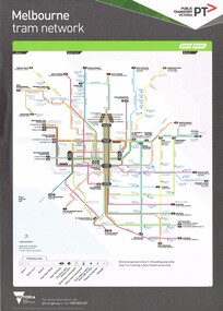
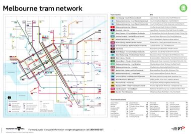 Melbourne Tram Museum
Map, Public Transport Victoria (PTV), "Melbourne tram network", "Victorian train network", May. 2017
A4 printed map, full colour published May 2017 titled on one side "Melbourne tram network" and the other "Victorian train network", showing the tram and train routes, and details of each route or line. Published by Transport for Victoria and PTV. Two copies held.trams, tramways, maps, railways, tramways, victoria, tram routes -
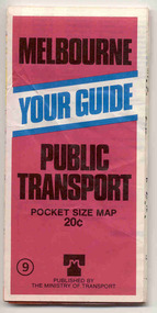 Ballarat Tramway Museum
Map, Ministry of Transport, "Melbourne Public Transport Map" - "No. 9", 1979
Pocket size - folded - public transport map of Melbourne, printed in colour on paper, showing public transport services in greater Melbourne and an index of localities. The Central zone area shown in detail. On the rear, route numbers and line maps of tram routes and train lines or services. Includes private bus routes. Printed for the Ministry of Transport. Issue No. 9. Dated 1979.trams, tramways, melbourne, map, routes -
 Robin Boyd Foundation
Map, Australia
Map with sealed roads around parts of AustraliaHandwriting with distances to Melbourne, Yass, Albury.walsh st library -
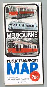 Melbourne Tram Museum
Map, Ministry of Transport, "Melbourne Transport Services Map - Tram, Train and Bus Services", 1976
Fold out map (27 sections 9 across x 3 deep), coloured of Melbourne's Tram and Bus routes, route numbers, rail lines, detailed for the central part of Melbourne and insert section for Frankston. On rear description of routes, private bus routes and map of Melbourne metro lines. Has contact details for bookings and lost property etc. Priced 20c Has a bus, silver train and a Z class tram on the cover. On bottom of outside cover, "No. 5 1976"On front cover in ink "5" in top right hand corner and "4 G 33 " along bottom edge.trams, tramways, melbourne, map, tram & bus services, railways, mmtb, minister for transport -
Stawell Historical Society Inc
Map
The Township of Elmhurst, Parish of Glenpatrick, Wimmera Districtstawell -
 Flagstaff Hill Maritime Museum and Village
Map - Survey Map, F.F. McGovern, Yangery - County of Villiers, 1884
A surveyor was employed to measure the land designated as Yangery, County of Williers, in the Borough of Warrnambool. The area on the map is similar to the earlier Farnham Survey undertaken by William Rutledge in the 1850's. Warrnambool was a Borough between 1863-1883. Coutours, waterways, sea and other significant points are shown. The distances are accurately measured. This survey map was used for planning future land sales, recreation areas and roads. WILLIAM RUTLEDGE (1806-1876) William Rutledge surveyed the land known as Farnham in southwest Victoria in 1843. His tenants made him a profitable business from working the land there. In 1863 Rutledge moved from nearby Port Fairy to Farnham and became very successful in breeding sheep, which he imported from J.R. Kirkham of Lincolnshire, England. He also bred horses on his land. The survey map of Yangery is important for its connection with renowned surveyor William Rutledge. The map shows the growth of landholders in the district when compared to the original Rutledge survey of the 1850's.Survey map of Yangery, titled "Yangery - County of Villiers". Printed on white paper, mounted on brown paper. c. 1863-1876. Comments printed on the Map include; Special Survey by William Rutledge, Photo-lithographed at the Department of Lands and Survey, Melbourne by W.J. Burson, Price 1/- [one shilling]. Scale is in Chains. Map has boundaries of Koroit Borough, Meerai, Purnim, Wangoom, Borough of Warrnambool, Mentions the Proposal of Tower HIll for Public Recreation. The map names the owners of the land at that time. Hand written pencil marks and figures and "Sauls fence" drawn on map. Hand written pencil markes and figures and "Sauls fence" drawn onto map. "For Department Use only". "Scale: 8 chains to 1 inch" flagstaff hill, warrnambool, shipwrecked-coast, flagstaff-hill, flagstaff-hill-maritime-museum, maritime-museum, shipwreck-coast, flagstaff-hill-maritime-village, county of villiers map, yangery district, w.j. burson, borough of warrnambool, koroit, purnim, meerai, wangoom, proposal of tower hill for public recreation, special survey by william rutledge, william rutledge, farnham, lincolnshire sheep, clydesdale -
Stawell Historical Society Inc
Map, 1945
William, County of Borungstawell -
Glen Eira Historical Society
Map - Kilvington Baptist Girls Grammar School
One hard copy and one photocopy of Kilvington Baptist Girls Grammar School Planning brief dated October 1982. The brief details the current needs of the school and has been written to spell out a forward plan for development in the foreseeable future. It includes data on the current forecast enrolments at primary and secondary levels as well as the current and future use and development of the buildings and their use. Author of the brief is unknown.kilvington baptist girls grammar school, schools, ormond, lillimur road, walsh street, ormond girls school, kilvington girls grammar school, leila road, katandra road, ulupna road -
Clunes Museum
Map
Photocopy of sections of Clunes gold mines, South Clunes United Co. 770 Feet, South No.4 Shaft, looking SouthNilmap of clunes mine, south clunes united co., no.4 shaft -
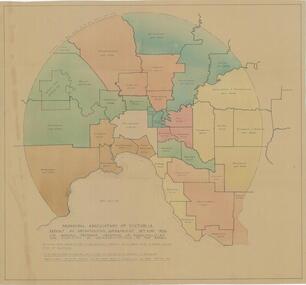 City of Whittlesea
Map - Maps, Municipal Association Of Victoria groupings of councils for representation, 1936
Map was produced as part of Municipal Association of Victoria report on Metropolitan Government, 18 May 1936. Map shows proprosed groupings of municipalities for election of representation to the MAV Board. Map includes net annual value of rateable property within each municipality. The net rateable value for metropolitan area of the Shire of Whittlesea in 1936 was £20,102. Maps, paper. Produced as part of Municipal Association of Victoria report on Metropolitan Government, 18 May 1936. Map shows proprosed groupings of municipalities for election of representation to the MAV Board. council, municipal association of victoria -
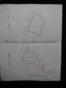 Churchill Island Heritage Farm
Map - Hand drawn map of Churchill Island, May 1939 (approx.)
Dr Harry Jenkins owned Churchill Island from 1936 to 1963 and bequeathed it to Margaret Campbell on his death. Sister Campbell had been nurse to his disabled son and wife and she lived on the island from the time of World War Two. The item was given to Arthur Evans, a family friend, on the day of the auction sale of artifacts when she sold the island, approximately 1973. This document is an example of a hand drawn map of the era, measured in links.Hand drawn map in pencil on paper of situation and measurements of land contained in Vendor's Title. Attached to solicitor's letter catalogue item No. 0108.1[signed] Hen B [bottom right hand corner]churchill island, purchase, harry jenkins, jenkins, margaret campbell, sister campbell, real estate, solicitor -
Whitehorse Historical Society Inc.
Map, Bike Paths, 1995
Map in Boroondara Bulletin showing Bike paths in the City of Boroondara.Map in Boroondara Bulletin showing Bike paths in the City of Boroondara.Map in Boroondara Bulletin showing Bike paths in the City of Boroondara.bicycle paths, city of boroondara -
Stawell Historical Society Inc
Map, Department of Lands and Survey Melbourne, Swinton Estate. Parish of Riachella. County of Borong, 3-08-1921
Shows part of Warranook TrainwayA1 Printed Map With Cloth Backing. Annotations in Red Ink W.J. Butson 3-8-21farming -
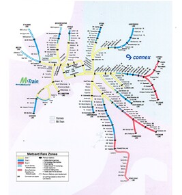 Melbourne Tram Museum
Map, VicTrip, Melbourne rail network - Connex and M>Train, 2000
Map - Colour print - of Melbourne's railway station network, shows the Connex and M>Train areas, zones, V/Line Metcards, Premium stations - used in Fares and Travel Guide - 2000 and 2001 Map - see Reg Item 2508. Also used in poster Reg Item 2514.trams, tramways, connex, map, melbourne, railways, m>tram, connex -
 National Vietnam Veterans Museum (NVVM)
Map
Very degraded paper map of PHUOC Tuy Province. Black and White Map - 1st Topographical Survey Troop Map.map -
Glenelg Shire Council Cultural Collection
Map, Railway Map of Victoria, n.d
Port of Portland CollectionFront: verso - 'Way and Works branch railway Department Melbourne Dec 1954.'port of portland archives, railway, map, 1954, 1950s -
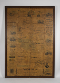 Bacchus Marsh & District Historical Society
Map, The Unique Advertising Combine, The Unique Combine's New Map of the Shire of Bacchus Marsh, 1890
This map was one of a number of similar maps produced for advertising purposes by a company called, 'The Unique Advertising Combine'. The company was located in Melbourne on Queens Walk. A brief item in the Bacchus Marsh Express newspaper on 29 March 1890 , page 2, indicated that subscribers to the Bacchus Marsh Express could obtain a copy of this map in the next issue of that newspaper. On the map is the detail that it was compiled by W.H. Bonney from official records supplied by D. A. Little, hire Secretary, (of Bacchus Marsh Shire).This map with its accompanying illustrations of local businesses and shops in Bacchus Marsh is an important documentary and visual snapshot of the town and district of Bacchus Marsh in the later part of the nineteenth century. The illustrations for some of the local businesses are the only known visual record of those particular buildings. The map is a rare surviving example of the material produced by The Unique Advertising Combine. Another similar example for the Shire of Mornington is held by the State Library of Victoria,A map of the Shire of Bacchus Marsh produced in March 1890. The map is mounted on a board and enclosed within a timber frame. The map includes an inset detail section showing the central part of the township of Bacchus Marsh including the main shopping and business streets. Land holdings with the first European land holders names indicated are included on the map. Rivers, creeks, major roads and the railway line are also shown on the map. Around the edges of the map are illustrated advertisements mostly for Bacchus Marsh businesses but which also includes some businesses located in Melbourne. maps bacchus marsh shire, shops bacchus marsh -
Port Melbourne Historical & Preservation Society
Education kit, The Gay Way series Nursery Rhyme Pictures Sets 1 & 11, c.1963
Used in infant grades to enhance the learning of nursery rhymes as well as to encourage children to examine a picture and talk about what they saw. The nursery rhymes illustrated are from the Gateway Series 1 & 2 - Twinkle, Twinkle Little Star: Polly put the Kettle on; Baa Baa Black Sheep; Queen of Hearts; Humpty Dumpty; Jack & Jill; There was a Crooked Man; Sing a song of Sixpence; There was an old Woman who lived in a Shoe; Old Mother Hubbard; Hot Cross Buns; Do you Know the Muffin Man, Pat a Cake; There was an old Woman tossed up in a Basket; Ride a Cock Horse; I saw a Ship go Sailing By; Curly Locks; Higgeldy Piggeldy;Diddle Diddle Dumping; Monday's Child: Little Tommy Tucker; Oranges & Lemons; Ding Dong Bell; Wee Willie Winkie; Old King Cole; Please to remember the 5th of November; Georgie Porgie; Three Little Mice sat down to Spin; The Man in the Moon; A Farmer went a Trotting..Large pale green folder containing 31 coloured nursery rhyme pictures.education - primary schools, state school 1427 nott street, gateway series nursery rhymes -
Clunes Museum
Map - MAPS / DOCUMENTS
.2 WAS MADE 1859.1 MAP OF CRESWICK CLUNES - 45 MINES NAMED IN CLUNES .2 DEPT. OF MINES SHOWING CLUNES - ENLARGEMENT - 100 IN CRESWICK, CRESWICK AND MCDONALD AND CO PREEMTIVE PURCHASE INDEXES OF QUARTZ AND A;LLUVIAL MINE LOCATIONS .3TOPHOGRAPHICAL MAP REF GF 23 CLUNES, MT GREENOCK TALBOT.1 360 SCALE 1 : 2500 .2 303/59 33 RECEIVED 15 OCTOBER 1859 SIGNED R. BROUGHTON, JAMES STEVENSON DISTRICT MINING SURVEYOR .3 40 CHAINS TO AN INCH mine sites, department of mines, creswick, clunes -
Stawell Historical Society Inc
Map, 1924
Bellaura, County of Borungstawell -
Whitehorse Historical Society Inc.
Map, Ringwood, 1935
Australia Ringwood and area map.Australia1:63,360 series map, Ringwood N.849 Zone 7. Scale 1 inch to 1 mile. Approximate scope: Prahran-Cockatoo, Lilydale-DandenongAustralia Ringwood and area map.maps, ringwood -
Koorie Heritage Trust
Education Kit, Aboriginal and Torres Strait Islander Commission, Indigenous Australia, 1993
Booklets to introduce Aboriginal culture and lifestyles past and present throughout Australia. Extra copies in stackin stack12 booklets ; in folder, 31 cm.Booklets to introduce Aboriginal culture and lifestyles past and present throughout Australia. Extra copies in stackin stackaboriginal australians -- social life and customs. aboriginal australians -- social conditions. aboriginal australians -- history. arts, aboriginal australian. -
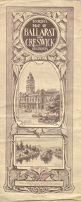 Federation University Historical Collection
Map, Ballarat and Creswick Districts, 1917, 14/03/1917
"... Three designs have been submitted to the Minister of Lands, at the Department's request, for the cover of a tourists' Guide book of the Ballarat and Creswick Districts. ..." (Ballarat School of Mines Principals Monthly Report, August 1916. Cat. No. 1110.12)A folded map of Ballarat and Creswick Districts which includes tourist destinations such as Creswick, Eureka Stockade, Sturt Street and Coliseum. Drawings are by Amalie Feild.ballarat, creswick, feild, amalie feild, ballarat town hall, park lake creswick, eureka memorial, university women -
 Melbourne Tram Museum
Map, Public Transport Victoria (PTV), "Melbourne tram network", 2015
Printed A4 sheet - double sided on off white paper titled "Melbourne tram network" with PTV, Metro, Yarra Trams logos, shows fare zones, ticketing, free tram zone.. Published 2015.trams, tramways, yarra trams, ptv, maps, free tram, melbourne -
City of Moorabbin Historical Society (Operating the Box Cottage Museum)
Education kit - Wood shaft writing pens and nibs, Steel Nib Manufacturer, mid 20thC
A dip pen usually consists of a metal nib with capillary channels like those of fountain pen nibs, mounted in a handle or holder, often made of wood. Dip pens have no ink reservoir, so the user must recharge the ink from an ink bowl or bottle to continue drawing or writing. Dip pens emerged in the early 19th century, when they replaced quill pens and were generally used before the development of fountain pens in the later 19th centuryThe pioneer settlers in the Moorabbin Shire area valued education and established schools for their children in Cheltenham and East Brighton c1860's These wood shaft pens and steel nibs are typical of the type used up to the mid 20th Century in school classes.3 wood shaft writing dip pens with steel nibs schools, education, writing equipment, victoria melbourne, market gardeners, pioneer, settlers, cheltenham state school no. 84., bentleigh east state school no. 2083, st stephens c of e school tucker road east brighton, pen steel nibs -
Canterbury History Group
Map - Camberwell and Boroondara, Melbourne and Metropolitan Board of Works, c.1905
Copy of Melbourne and Metropolitan Board of Works Plan no. 71 for Camberwell and Boroondaracanterbury, maps, melbourne and metropolitan board of works -
Port Melbourne Historical & Preservation Society
Map - West and North Melbourne, MMBW, 21 Feb 1936
Melbourne and Metropolitan Board of Works plan No 24 of West and North Melbourne Docklands,1936signed A.W. Walkermmbw, melbourne and metropolitan board of works, a w walker -
Whitehorse Historical Society Inc.
Map, Parish of Bulleen, 1892
Copy of map of the Parish of BulleenCopy of map of the Parish of Bulleen together with North-East portion of the Parish of Nunawading.Copy of map of the Parish of Bulleenmaps, parish of bulleen, parish of nunawading