-
 Churchill Island Heritage Farm
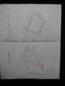
Map - Hand drawn map of Churchill Island, May 1939 (approx.)
Dr Harry Jenkins owned Churchill Island from 1936 to 1963 and bequeathed it to Margaret Campbell on his death. Sister Campbell had been nurse to his disabled son and wife and she lived on the island from the time of World War Two. The item was given to Arthur Evans, a family friend, on the day of the auction sale of artifacts when she sold the island, approximately 1973. This document is an example of a hand drawn map of the era, measured in links.Hand drawn map in pencil on paper of situation and measurements of land contained in Vendor's Title. Attached to solicitor's letter catalogue item No. 0108.1[signed] Hen B [bottom right hand corner]churchill island, purchase, harry jenkins, jenkins, margaret campbell, sister campbell, real estate, solicitor -
 Bendigo Historical Society Inc.
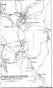
Map - STATE RIVERS AND WATER SUPPLY COMMISSION : COLIBAN SYSTEM OF WATERWORKS MAP
State Rivers and Water Supply Commission. Photocopied foolscap-size map. Title: Coliban System of Waterworks. Channels, reservoirs, reticulation systems. Maldon - S.R. & W.S.C. reticulated towns. The map includes the areas from Goornong to south of Kyneton and across to Maldon: Goornong, Marong, Bendigo, Strathfieldsaye, Lockwood, Maldon, Harcourt, Castlemaine, Newstead, Elphinstone, Taradale, Malmsbury, Kyneton.state infrastructure, water supply, coliban system, state rivers and water supply commission. coliban system. -
 University of Melbourne, Burnley Campus Archives
Plan, Noel O'Keefe, Perennial Border Spring Display, 1994
Drawing No 1 by Noel O'Keefe. 15.07.1994. (Also see 11.0602).noel o'keefe, perennial -
 Bendigo Historical Society Inc.
Map - JACK FLYNN COLLECTION: MUSKERRY, 1962
Map: Parish of Muskerry, County of Rodney. Parish plan.By Authority: A.C. Brooks, Government Printer, Melbourne. Drawn and reproduced at the Department of Lands and Survey, Melbournemap, rodney, parish plan, muskerry -
 Federation University Historical Collection
Plan, Plan of Survey Crown Allotment 9A and Part of Crown Allotment 8 Section 10 City and Parish of Ballaarat, after 1929
ink and watercolor on watermarked laid paper dated 1928text and measurementsballaraat, ballarat, plan, plan of survey, armstrong street, skipton street -
University of Melbourne, Burnley Campus Archives
Plan, City of Richmond Development of Old Burnley School Site, c. 1986
Plan for Park. Scale 1:200. CP-72047186.richmond, burnley -
 Ballarat Heritage Services
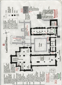
Plan, Lanercost Priory, Digital copy made 2016
Lanercost Priory was founded around 1169 by Robert de Vaux, and was home to an order of Augustinian canons until 1538 when is was dissolved by Henry VIII. In 1542 the priory and lands were granted to Thomas Dacre, an illegitimate son of Thomas, Lord Dacre. Mason's marks can be found throughout the undercroft. Plan on white paper with black and red ink printing and a drawingEnglish Heritage Lanercost Priorymason's marks, marks, stone marks, stonemasons, lanercost, priory, plan, 1169 -
Bendigo Historical Society Inc.
Map - TOWN OF INGLEWOOD, March 1946
Map: Town of Inglewood, Parish of Inglewood, County of Gladstone. Parish planmap, gladstone, township, inglewood -
Moorabbin Air Museum
Plan (item) - Bristol Aeroplane 170 schematic drawings, Assy. Real Spar Starboard
Bristol Aeroplane Company Ltd -
Bendigo Historical Society Inc.
Map - CAMPBELL COLLECTION: BENDIGO AND DISTRICT MAPS
Map. Bendigo & District. The same as 10104.1. The map is in a very damaged condition.map, bendigo, allotments -
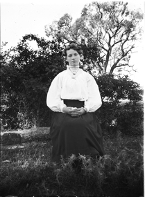 Wodonga & District Historical Society Inc
Negative - Haeusler Glass Negatives Collection - A young woman seated outside, c1910
The Wodonga Historical Society Haeusler Collection provides invaluable insight into life in late nineteenth and early twentieth century north east Victoria. The collection comprises manuscripts, personal artefacts used by the Haeusler family on their farm in Wodonga, and a set of glass negatives which offer a unique visual snapshot of the domestic and social lives of the Haeusler family and local Wodonga community. The Haeusler family migrated from Prussia (Germany) to South Australia in the 1840s and 1850s, before purchasing 100 acres of Crown Land made available under the Victorian Lands Act 1862 (also known as ‘Duffy’s Land Act’) in 1866 in what is now Wodonga West. The Haeusler family were one of several German families to migrate from South Australia to Wodonga in the 1860s. This digital image was produced from one of the glass negatives that form part of the collection, probably taken by Louis Haeusler (b.1887) with the photographic equipment in the Wodonga Historical Society Haeusler Collection.This item is unique and has well documented provenance and a known owner. It forms part of a significant and representative historical collection which reflects the local history of Wodonga. It contributes to our understanding of domestic and family life in early twentieth century Wodonga, as well as providing interpretative capacity for themes including local history and social history.Digital image created from the Haeusler Glass negative collection. A young woman seated outside. She is wearing a white, high-necked blouse and dark skirt.wodonga pioneers, haeusler family, glass negatives, dry plate photography, wodonga families -
Bendigo Historical Society Inc.
Map - TALAMBE : COUNTY OF BENDIGO, 21-3-27
Map. Talambe, County of Bendigo, Hayanmi, Calivil, Pompapiel, Yallook, Tandarra, Dingee. Photo-Lithographed at the Department of Lands and Survey, Melbourne, by W.J. Butson 21-3-27, Price 2/-. (number 27 in map cupboard 1)W.J. Butsonmap, bendigo, talambe -
 Kew Historical Society Inc
Plan - Subdivision Plan, Jas R Mathers Son & McMillan, Macartney Estate, East Kew, c. 1925
Pru Sanderson, in her groundbreaking ‘City of Kew Urban Conservation Study : Volume 2 - Development History’ (1988), summarised the periods of urban development and subdivisions of land in Kew. The periods that she identified included 1845-1880, 1880-1893, 1893-1921, 1921-1933, 1933-1943, and Post-War Development. These periods were selected as they represented periods of rapid growth or decline in urban development. An obvious starting point for Sanderson’s groupings involved population growth and the associated economic cycles. These cycles also highlighted urban expansion onto land that was predominantly rural, although in other cases it represented the decline and breakup of large estates. A number of the plans in the Kew Historical Society’s collection can also be found in other collections, such as those of the State Library of Victoria and the Boroondara Library Service. A number are however unique to the collection.Subdivision plans are historically important documents used as evidence of the growth of suburbs in Australia. They frequently provide information about when the land was sold on which a built structure was subsequently constructed as well as evidence relating to surveyors and real estate and financial agents. The numerous subdivision plans in the Kew Historical Society's collection represent working documents, ranging from the initial sketches made in planning a subdivision to printed plans on which auctioneers or agents listed the prices for which individual lots were sold. In a number of cases, the reverse of a subdivision plan in the collection includes a photograph of a house that was also for sale by the agent. These photographs provide significant heritage information relating house design and decoration, fencing and household gardens.The Macartney Estate subdivision advertised 21 lots for sale on either side of Macartney Street (now Macartney Avenue) and Evans Road in what was then designated as East Kew. Most of the houses shown on the south side of Macartney Street then, as now, have rear entrances on Mount Street, however a number of these blocks have since been further subdivided to allow for the building of new houses on the rear of a block. Brougham Place is marked on the plan but is now called Daniell Place."C"subdivision plans - east kew, macartney estate, macartney street, mount street, evans road, brougham place -
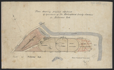 University of Melbourne, Burnley Campus Archives
Plan, John S. Jenkins, Plan showing proposed adjustment of boundaries of the Horticultural Society's Gardens in Richmond Park, c.1880-1884
Plan on linen fibre cloth. Shows layout of Burnley bound by Swan St., Yarra River and part of Richmond Park, coloured areas showing proposed area to be added to Park, the old road, shrubbery, new hall, old garden, recent extension and proposed further extension (crossed out in red ink). Scale 4 chains:1 inch. Probably drawn by John S. Jenkins, Town Surveyor, Richmond. Has been photographed so that additional copies can be made. On a CD plus 3 negatives. (Also copy glazed and framed for Centenary Exhibition.)john s. jenkins, gardens, richmond, hoticultural society of victoria -
Stawell Historical Society Inc
Map, Navarre, County of Kara Kara, 1925 & 1955
Navarre, County of Kara Karastawell -
Glenelg Shire Council Cultural Collection
Negative - Glass Plate Negative - Fawthrop Lagoon Portland, 1890-1910
Glass plate negative. Two men and two women in a clinker built dinghy on Fawthrop lagoon. Estimated dress to be late 19th, early 20th Century. -
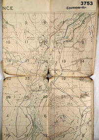 Bendigo Military Museum
Map - TRENCH MAP WW1, 1918
Areas covered on this map, “Coisy, Allonville, Busy, Franvillers” Item re William Alexander No 502 AIF. Refer Cat No 3746.3 for his service details.Trench map, France, Edition 2A, sheet 62D N.W, scale 1:20,000, trenches corrected to 7.5.1918, British trenches in blue.On outside drawn in purple “62D N.W 1:20,000”map, france, trench -
 Ringwood and District Historical Society
Map - State Aerial Survey, Dandenong Ranges Area, Parishes of Warrandyte and Ringwood - 1956
Map of central and southern areas of Ringwood and part of Ringwood East and Heathmont compiled by Dept of Lands and Survey, July 1956, from aerial photographs and Cadastral Survey information. Subsequent hand-drawn addition of streets showing layout of "Township of Ballyduffy Estate 1858-60", an earlier proposed subdivision that did not eventuate. (See attached 5009b Ballyshanassy_ Melbourne’s lost suburb.pdf for Ballyduffy historical naming relevance). Ballyduffy Estate streets include City Road, West Prussia Road, Duffy Street, Ireland Street, Evans Street, Victoria Street, Regina Street, Short Road, Prussia Road, Duffy Street East, Ireland Street East, Evans Street East, Chapman Street. Misc Topo 93 Sheet 22, Ringwood A4B2. Scale: 4 chains to 1 inch. Contour interval 20 feet. -
Bendigo Historical Society Inc.
Map - CAMPBELL COLLECTION: BENDIGO & DISTRICT MAPS
Map. Lockwood, Parishes of Lockwood and Shelbourne. Scale 20 chains to 1 inch.Total area 4405 acres. Bullock Creek to the right, Spring Creek at Centre. Newbridge is 11 miles N E, To Marong, Bendigo Lockwood roads are on the left. (number 375 in map cupboard 1)map, bendigo, agricultural lands -
Melbourne Tram Museum
Essay, Dean Gilbert, "Moving the mail by tram", 2018
Written by Dean Gilbert, as a former MMTB Head Office junior clerk and Revenue clerk - titled "Moving the mail by tram" describing how the mail was moved from depots to Head Office and back using satchels. Also notes the payroll numbering system. Part printed in the Dec 2018 issue of Bellcord.yields information about MMTB correspondence or mail procedures and payroll numbering system.Essay - 7 A4 pages with photos - two punch holes on left hand side.mmtb, mail, head office, depots, revenue clerks -
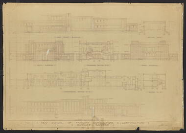 University of Melbourne, Burnley Campus Archives
Plan, New School of Primary Agriculture & Horticulture: Burnley Gardens, 1945
Original and photocopy of detailed architectural drawing and plan of new school by the Department of Public Works, Victoria Chief Architect, P. Everett.burnley school of horticulture, burnley gardens, percy everett -
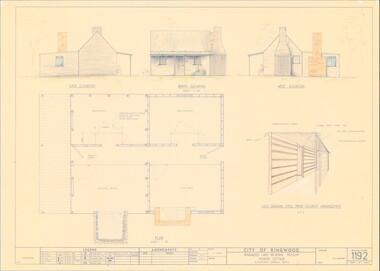 Ringwood and District Historical Society
Plan - Ringwood Lake Reserve Museum Miners Cottage - 1983, Detailed Building Plans - 4 Sheets
Sheets 1, 2, 3 & 4 - Structural drawings for construction of miners cottage museum at Ringwood Lake Reserve, opened May, 1983. -
 Melbourne Tram Museum
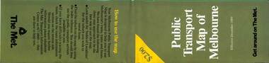
Map, The Met, Public Transport Map of Melbourne - Get around on The Met, 12/1989
Melbourne transport map - dated December 1989 - scratch ticket system, has a photo of the front of B2 2004, includes a map of the ticket zones, and The Met contact details.Yields information about Melbourne public transport services in December 1989 following the introduction of Scratch tickets.Fold out map (36 sections 9 across x 4 deep), "Public Transport Map of Melbourne", coloured of Melbourne's Tram and Bus routes, route numbers, rail lines, detailed for the central part of Melbourne and the outer Metropolitan services.tramways, melbourne, tram services, bus services, railways, maps, zones, scratch tickets -
Bendigo Historical Society Inc.
Map - NEWSTEAD, 1/11/1939
Map: Town of Newstead, Parish of Strangways, County of Talbotmap, talbot, township, newstead, parish of strangways, county of talbot -
 Bacchus Marsh & District Historical Society
Map, Bacchus Marsh Township and Nearby Districts Maps Volume
This volume of maps is believed to have been compiled by staff at the Shire of Bacchus Marsh and was presumably used to inform and assist Shire staff and Councillors in the carriage of their duties.This collection of maps are significant due to their rarity as many of them are unique maps made for local purposes in the Bacchus Marsh region. They are also of strong research value containing a wide variety of information including landholders, land sales, infrastructure, such as roads, bridges, public, commercial and private buildings, houses, land use, and geographic features over multiple decades from the late nineteen century into the middle part of the twentieth century.One bound volume of maps comprising cadastral maps, (indicating property owners and land boundaries), land plans and real estate auction plans and advertising material, and other maps indicating major infrastructure like proposed roads and irrigation areas. Most of the maps and plans are of Bacchus Marsh and nearby areas but some maps are of nearby towns such as Melton, Ballan and Blackwood. The volume comprises 52 pages. Most pages have a single map or plan pasted onto it but some contain 2 or 3 different maps. There are 81 maps in total. Map 1 Liquidators Sale 1896. Map 2. Woodside Estate Sale 1913. maps, maps bacchus marsh, maps bacchus marsh region -
Bendigo Historical Society Inc.
Map - CAMPBELL COLLECTION: BENDIGO AND DISTRICT MAPS
Map. Longlea, Parishes of Eppalock and Axedale. Scale 20 chains to 1 inch. Total area of map 2372 acres, with Bendigo 9 1/2 miles away. H.A. Darby 18-6-29. (number 349 in map cupboard 1)H.A Darbymap, bendigo, allotments -
 Eltham District Historical Society Inc
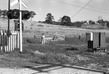
Negative - Photograph, Shire of Eltham, Allendale Road level crossing, Eltham, Jan. 1980
allendale road, diamond creek trail, hurstbridge railway line, level crossing, power transmission lines, railway crossing -
Bendigo Historical Society Inc.
Map - CITY OF BENDIGO SHEET NO. 6, surveyed 3/03/1882
Map: City of Bendigo sheet No. 6 . Parish plan ( number 215 in Map Cupboard 1)map, bendigo, parish plan, bendigo -
 Eltham District Historical Society Inc
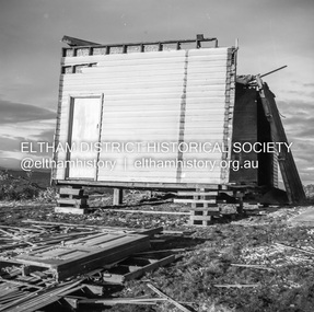
Negative - Photograph, J.A. McDonald, Inspection of storm damaged Abraham house at Kangaroo Ground, c. May 1962
Showing the effect of a wind storm that destroyed the house circa May 1962.. The Abraham family owned land near the Aqueduct and east of Nicholas Lane at Kangaroo Ground (based on photos, at or near 40 Nicholas Lane).Record of various Shire of Eltham infrastructure works undertaken during the period of 1952-1962 involving bridge and road reconstruction projects, sometimes with Eltham Shire Council Project Reference numbers quoted. It was during this period that a number of significant improvements were made to roads and new bridges constructed within the shire that remain in place as of present day (2022). In many situations, the photos provide a tangible visible record of infrastructure that existed throughout the early days of the Shire. The album was put together by or under the direction of the Shire Engineer, J.A. McDonald.1962-05, abraham house, kangaroo ground, nicholas lane, property damage, storm damage -
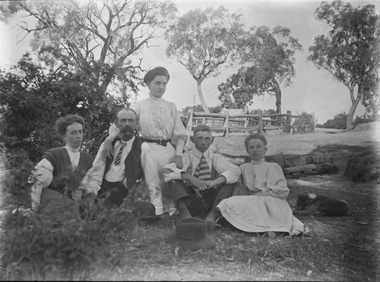 Wodonga & District Historical Society Inc
Negative - Haeusler Glass Negatives Collection - Family group seated outside, c1910
The Wodonga Historical Society Haeusler Collection provides invaluable insight into life in late nineteenth and early twentieth century north east Victoria. The collection comprises manuscripts, personal artefacts used by the Haeusler family on their farm in Wodonga, and a set of glass negatives which offer a unique visual snapshot of the domestic and social lives of the Haeusler family and local Wodonga community. The Haeusler family migrated from Prussia (Germany) to South Australia in the 1840s and 1850s, before purchasing 100 acres of Crown Land made available under the Victorian Lands Act 1862 (also known as ‘Duffy’s Land Act’) in 1866 in what is now Wodonga West. The Haeusler family were one of several German families to migrate from South Australia to Wodonga in the 1860s. This digital image was produced from one of the glass negatives that form part of the collection, probably taken by Louis Haeusler (b.1887) with the photographic equipment in the Wodonga Historical Society Haeusler Collection.This item is unique and has well documented provenance and a known owner. It forms part of a significant and representative historical collection which reflects the local history of Wodonga. It contributes to our understanding of domestic and family life in early twentieth century Wodonga, as well as providing interpretative capacity for themes including local history and social history.Digital image created from the Haeusler Glass negative collection. A family group of husband, wife and three children seated outside. A house and fenced yard is in the background. C. 1910wodonga pioneers, haeusler family, glass negatives, dry plate photography