-
 Glenelg Shire Council Cultural Collection
Financial record - Passbook - State Savings Bank of Victoria, Portland Free Library, 1922-1924
Front: purple stamp 'Cancelled carried forward to new passbook' 2 purple stamps 'PFL & LI' Back: 2 'cancelled' stamps, 1 PFL&LI' stampglenelg shire council archives, portland free library, administration, finance, savings -
Moorabbin Air Museum
Map (item) - AUS-RNC #2,3,4,5 ADL-MEL-SYD-BRI-TOW-CAI-PTM 1973/4
-
Whitehorse Historical Society Inc.
Map, Parish of Nunawading, 1853
Photocopy of manuscript map with allotments numbered and named.Photocopy of manuscript map with allotments numbered and named. Note on verso: Parish of Nunawading, County of Bourke. Gardiners Creek, Ballyshanassey Township, surveyed by H. Parmein, Surveyor General's office, Nov 30th 1853 [enlargement of ND2801, no list of corner references]Photocopy of manuscript map with allotments numbered and named. maps, gardiners creek, ballyshanassy, burwood east, parmein, h -
 National Vietnam Veterans Museum (NVVM)
Map, Long Tan Original Battle Map
Original topographical map of Long Tan area showing operational marking in black pen. Areas 1-4 marked 5RAR section.This map is the original map from 1 ATF HQ on the day of the Battle of Long Tan, 18th August, 1966.battle of long tan, map -
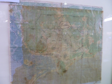
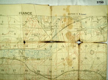 Bendigo Military Museum
Map - TRENCH MAP WW1, 1918
Areas covered on this map “Corbie, Villers Brettoneux, Hangard, Blangy and Tronville Wood, River Somme”. Item re William Alexander No 502 AIF. Refer Cat No 3746.3 for his service details.Trench map, France, Edition 3B, trenches corrected to 7.7.1918, German trenches in red, British in blue, scale 1:20,000.map, france, trench -
Clunes Museum
Financial record - LEDGER, Day Book
Used in Theo Harden's Boot and Shoe Emporium, Fraser Street, ClunesLarge book with leather spine with "Day Book" label. Brown fabric cover.Day Book on labellocal history, books, day bookbusinesses of clunes -
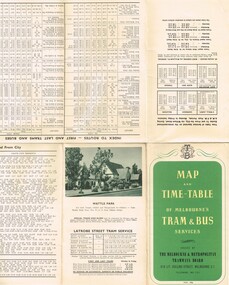 Melbourne Tram Museum
Map, Melbourne & Metropolitan Tramways Board (MMTB), "Map and timetable of Melbourne Tram and Bus Services" - May 1956", May. 1956
Fold out map (10 sections), coloured of Melbourne's Tram and Bus routes, route numbers, rail lines, municipalities boundaries and location of major places of interest. Titled - "Map and timetable of Melbourne Tram and Bus Services" - May 1956". At base of map - timetable of all night trams and bus services. On rear index to routes, 1st and last services, time of Sunday am services, LaTrobe St. services and photo of Wattle Park. Dated May 1956. Note the inset map shows Bourke St as a bus. Three copies held. 413.1 - as for above but with a pasted over section titled "Time table of all - night bus services" on the base of the map replacing the all night tram and bus services. Dated 3/7/1957. Copy from donation of Gary Butler added 3/12/15. See Reg Item 2300 for the March 1952 version.trams, tramways, melbourne, map, tram & bus services, all night services, mmtb -
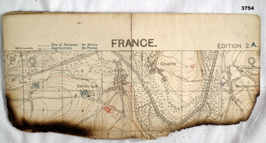 Bendigo Military Museum
Map - TRENCH MAP WW1, 1918
Areas covered on this map, “Hamel, Mericourt, Proyart, Weincourt, Harbonnieres”. Item re William Alexander No 502 AIF. Refer Cat No 3746.3 for his service details.Trench map, France, Edition 2A, sheet 62D S.E, scale 1:20,000, trenches corrected to 22.4.1918, trenches in red. On outside in blue handwriting “62D S.E”map, trench, france -
Stawell Historical Society Inc
Map, Plan of the Principal Underground Workings at Stawell, 1894
Plan of the Principal Underground Workings at Stawellstawell, mining -
 Federation University Historical Collection
Map, Ballarat Goldfield, c1898
This map shows geological features, suggests the last basalt flow, and includes alotments and names of Mining Companies. Although this map has no date on it the Ballarat Industrial School is used for dating purposed. The Ballarat Industrial School ran from 1869-1879, but the term Ballarat Industrial School Reserve was still in use in 1898 and possibly beyond.Geological Map of Ballarat with 3 holes in the left hand side. The map indicates the position of Lake Wendouree, Township of Warrenheip, Ballarat East, Industrial School Reserve, Winters Swamp, Police Paddock, Wyndholm Premptive Right (Salton and Waldie), Black Hill, Vale Park Reserve, Pennyweight Hill, Little Bendigo, Black Swamp Lead, monte Christo Reef, Chinaman's Gully, Miners Rest, Pincotts Dam, Northumberland Gully. It also show the following goldmining companies: City of Ballarat, Kohinor, Hand and Band, Great North West, Northern Junction, Kneeshaw, Rossers Freehold, Silurial.ballarat, warrenheip, lake wendouree, ballarat east, winters swamp, winter swamp, wyndholm premptive right, cemetery, vale park reserve, little bendigo, kneeshaw co., industrial school reserve, kirks dam, pincotts dam, black hill, wombat hill, dead horse gully, miners rest, mt rowan, salton and waldie, rose hill co, great north west no 1, rose's freehold co, hand and band co, police reserve, police paddock, mount rowan, ballarat industrial school reserve, market reserve, winter's swamp, kneeshar co, monte cristo line of reef, chinaman's gully or black snake, milkmaid's gully, ballarat gold field, bakery hil lead, old gravel pits lead, golden point lead, eureka lead, miner's rest, yarrowee creek, leigh creek, black swamp lead, yorkshire reef, nil desperandum reef, cockatoo lead, hit or miss gully, herbert werner frederick de nully, pennyweight hill, esmond's lead, ash's lead, nightingale lead, john bull gully, gladstone reef, whitehorse reef, petticoat creek, pincott's dam, frenchman's gully, tim's crushing plant, jenkin's gully, california gully, drake's creek, sulton and waldie, ballarat undustrial school -
Whitehorse Historical Society Inc.
Map, Map of Mitcham, Tunstall and Blackburn, c1937
Map of Mitcham, Tunststall and Blackburn showing the location of T.M. McDonnell, real estate agent, Whitehorse Road, MitchamMap of Mitcham, Tunststall and Blackburn showing the location of T.M. McDonnell, real estate agent, Whitehorse Road, MitchamMap of Mitcham, Tunststall and Blackburn showing the location of T.M. McDonnell, real estate agent, Whitehorse Road, Mitchammaps, mcdonnell, t.m. -
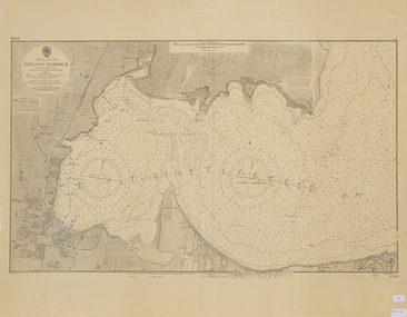 Queenscliffe Maritime Museum
Map - Chart of Geelong Harbour, Geelong Harbour
When Hamilton Hume and William Hovell arrived at the bay in 1824 they met with the local Wautharong people who referred to the bay as "Jillong" and the surround land "Corayo", but by the time the area was surveyed in the late 1830s the Aboriginal names had been swapped. The names "Corayo" and "Jillong" had since been Anglicised to "Corio" and "Geelong".Corio Bay is an important harbour and leisure location in the West and continues to attract development such as the new Tasmania Ferry Terminal.An Admiralty Chart of Geelong Harbour revised in 1954Geelong Harbour Map Ref: 2731geelong, corio, admiralty charts -
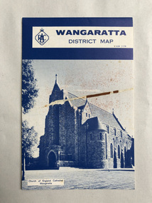 Robin Boyd Foundation
Map, RACV General Insurance, RACV Wangaratta District Map
District Map of Wangaratta and surrounding townshipswangaratta, victoria, map, beechworth, albury-wodonga, walsh st library -
Beechworth Cemetery Trust
Map - Beechworth Cemetery reproduction of original map - On site in Rotunda, Beechworth Cemetery
Reproduction map displaying all grave sites in Beechworth Public Cemetery. Rotunda, fountain, nursery, memorial wall, pioneer sectionmap displays the plan of grave sitesLaminated Photocopy of original cemetery map with additional information hand-written on the map. All graves at the cemetery set out in denominational sections with hand-written information on additional graves added to sections in Roman Catholic A & C, Church of England A-F, Presbyterian A-C, Methodist/Uniting B and Wesleyan A. Multidenominational hand-written note on Jews section with Trust Minutes 4.7.'83 written next to this addition. Additions hand-drawn of fountain, memorial wall, nursery and pioneer cemetery.rotunda, fountain, nursery, memorial wall, pioneer section, graves, chinese section, un-numbered grave sites, cemetery -
 Ballan Shire Historical Society
Map - Map. Bungal, Department of Lands and Survey, Bungal, County of Grant, 09/09/1926
A map of Bungal in the 1920's showing the allotments, and the size, with the names of the residents. It shows the roads and the Western and Eastern Moorarbool River, and the Whipstick State Forest.Cream coloured map of Bungal in the County of Grant, bounded by the the East Moorarbool River on the East, and the State Forest on the South. It is marked with the scale of chains and the number L.358. Lithographed at the Department of Lands and Survey. Melbourne by W. J. Butson on 9.9.1926. It shows the land allotments with names of owners.Coloured pen marks and circled numbers on various areas. Price 2 shillings marked on bottom right hand edge.bungal, kerrit bareet, egerton, lal lal, borhoneyghurk, bungeeltap, ballark, yaloak, gorong, moorarbool west -
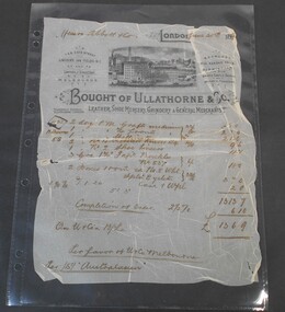 Bendigo Historical Society Inc.
Financial record - Abbott Collection: Invoice
An invoice from Ullathorne & Co. leather, shoe mercery, grindery & general merchants dated June 30th 189? issued to Messrs. Abbott & Co. for a total of 13 pounds 6 shillings 9 pennies.invoice, abbott, business -
Stawell Historical Society Inc
Map, Shire of Stawell
Shire of Stawellstawell -
Moorabbin Air Museum
Map (Item) - RACV Royal Automobile Club Melbourne Victoria and Suburbs map
-
Stawell Historical Society Inc
Map, Gold Mines of Australia, Gold Mines of Australia underground workings. Newington Rd Darlington Rd Area 1950, 1950
Plans Showing Surveys & Drilling Stawell InvestmentGold Mines of Australia Stawell Investment 2003 mining, gold, map -
Whitehorse Historical Society Inc.
Map, Blackburn Lake, c1968
Enlarged aerial photograph of Blackburn Lake area.Enlarged aerial photograph of Blackburn Lake area.Enlarged aerial photograph of Blackburn Lake area.blackburn lake sanctuary, adult deaf & dumb home, lake road, blackburn, central road, blackburn, aerial photographs -
 Whitehorse Historical Society Inc.
Map - Civic maps, City of Nunawading, City of Nunawading Maps
A collection of maps of the City of Nunawading from Diana Coles, City of Whitehorse Community Chest.8 printed maps of various sizes covering city of Nunawading. Scale 1:2500non-fictionA collection of maps of the City of Nunawading from Diana Coles, City of Whitehorse Community Chest. coles diana, civic maps, city of nunawading, whitehorse road, blackburn road -
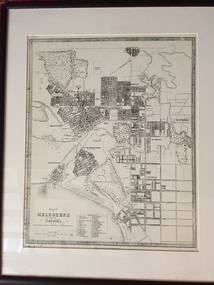 Port Melbourne Historical & Preservation Society
Map - Plan of Melbourne, 1855
Framed copy of 1855 "Plan of Melbourne and its suburbs". Black frame. Some writing can be seen on left hand side of print.built environment, melbourne and metropolitan board of works -
Greensborough Historical Society
Map, Victoria: Yan Yean, prep. by Australian Section of Imperial General Staff, 1935
Part of 1:63,360 series of survey mapsColour copy from original. Scale: 1: 63,360 (1 inch to 1 mile) 2 copiesRev. 1930 by Australian Survey Corps using RAAF Air Photos. yan yean -
Glenelg Shire Council Cultural Collection
Financial record - Account Rendered and Envelope, 30/09/1935
a. Account rendered from Garnet B. Frost, Barrister and Solicitor, to H.L. Vivian. Printed form, details typed, amount: £8.9.6 b. Envelope for above account rendered, white, plain. 'Mr. H.L. Vivian, PORTLAND' typed on front -
Port Melbourne Historical & Preservation Society
Map - Chart, Hobson's Bay, river and navigational aids, 1839 - 1843
Map (Chart) of Hobson's Bay, River and Navigational Aids 1839. (Latrobe Library). in photographic form.melbourne harbor trust - port of melbourne authority, hobson's bay -
Glenelg Shire Council Cultural Collection
Financial record - Financial record - Rate notice Portland Town Council, 23 Short St Portland, Victoria, 23/03/1964
a) Rate notice issued by Portland Town Council for 23 Short St Portland, to Mrs Dawn R Barclay b) Receipt for above, dated 14 Apr 1964 c) Town of Portland envelope, containing a) and b) -
Glenelg Shire Council Cultural Collection
Financial record - Account - J. Campbell Family Draper to Mrs Cummins, n.d
Account from J. Campbell, wholesaler and family draper to Mrs Cummings, in the sum of 4/6 for a blouse. Printed form, details handwritten in black ink.draper, portland trade, accounts, womens clothing -
Stawell Historical Society Inc
Map, Agricultural Area of Lake Wilson, Parishes of Bellaura & Bellellen, 1865
Agricultural Area of Lake Wilson, Parishes of Bellaura & Bellellenstawell -
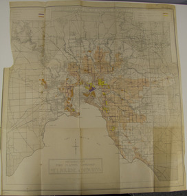 Glen Eira City Council History and Heritage Collection
Map - Map, zoning, Metropolitan Town Planning Commission, "DISTRIBUTION AND USE OF EXISTING PROPERTY. MAP NO. 6.", 1929
The map titled: “Distribution and use of Existing property map No. 6” (Metropolitan Town Planning Commission Melbourne and Suburbs) is of historical significance. It is listed on page 168 of Chapter 4 the Zoning section of the "Plan of General Development Melbourne Report of the Metropolitan Town Planning Commission 1929" - Melbourne's first strategic plan. Map No. 6 is mentioned throughout Chapter 4 of the 1929 Report. It states on page 156 that this Map was created to graphically illustrate the data collected by the Planning Commission. The Map illustrates the general distribution of uses of existing property throughout the metropolitan area. The coloured sections show the areas which were developed or were in the process of development in 1929. The colours indicate the distribution of uses in the developed areas. The pink coloured areas, which include Caulfield, were almost completely residential.1929, metropolitan town planning commission, melbourne, suburbs -
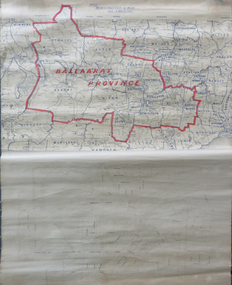 Federation University Historical Collection
Map, Ballarat Municipalities and City Boundary
Piece of linen attached at top and bottom with wooden rails. Top half of linen has a paper map of Ballaarat Province and Surrounding Municipalities directly attached to it and reads 'Ballaarat Province' in red ink which outlines the greater Ballarat area with surrounding municipalities shown in blue. Scale is '8 miles to 1 inch'. Bottom half is drawn directly onto linen and depicts Ballaarat City Boundary including street names. 'Scale about 20 chains to 1 inch'.ballarat electorate, map, ballaarat province, ballarat to buninyong railway