-
 Bendigo Historical Society Inc.
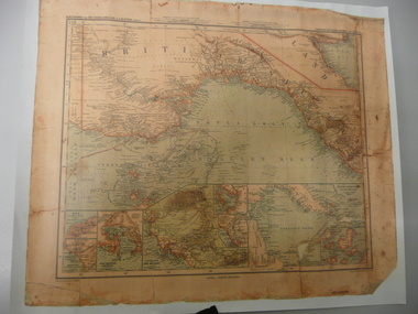
Map - STRAUCH COLLECTION: MAP BRITISCH PAPUA
Copy of original heritage map of ''Britisch Papua'' (N.G.) detailed & mapped by German (marine navigator) 'Gezeichnet von C.Barich & produced in the 'Langhans Deutscher Kolontal Atlas, Feb. 1893. Presented to German Society, 30.5.2008 by Mr P.Thwaites, Plans & Projects Officer (Digo 2008) Plus Society's laminated work copy of same map.map -
 Warrnambool and District Historical Society Inc.
Map - Maps, Soldiers Settlement WW2, Circa 1950
The soldiers' settlement scheme operated after the first and second world wars in an effort to more closely settle the land and also give opportunities to returned soldiers. Crown land and other larger estates were acquired for the purpose. Most of these maps relate to the area north of Warrnambool where many of the subdivisions were parts of larger estates.These maps pertaining to the Soldiers' Settlement program, relate to an interesting part of Australian and local history. As such they have historic and social interest and significance.A collection of 25 paper maps which relate to to the soldiers settlement post World War 2. Some have details of the people allocated the land and some smaller maps have the printed details of the applicants requirements.Text is black on white paper which in some cases is quite aged. The maps are as follows: .1 Narrapumelap Estate ( Ripon & Hampden) .2 Narrapumelap Estate Part 2 (Villers & Ripon) .3 Narrapumelap Estate Part 3 ( Villiers & Ripon) .4 Burrumbeet Estate ( Ripon) .5 ' Berrambool' Estate 9 Hampden & Villiers) .6 ' Hopkins Hill' Estate Villiers 4011 acres .7 Caramut North No 2 Estate ( Villiers ) .8 ' Morpor' Estate ( Villiers) 4172 acres .9 ' Morgiana' Estate ( Normandy) 3453 acres .10 ' Chatsworth House' ( Villiers) 9341 Acres .11 ' East Elwood' Estate Villiers 2407 acres .12 Grey's Estate ( Mornington) 1151acres .13 ' Rowes Estate' ( Buln Buln Gippsland 733 acres .14 'Tarrone' Estate No 2 Part map .15 'Chaldon Meade' Estate (Bourke) Bulla 517 acres .16 ' Terranallum South' Estate Hampden 3757 acres .17 ' Brung Brungle' Estate Dundas 695 .18 ' Armidale ' Estate ( Dundas)2108 acres .19 ' Moyne Falls' Estate ( Villiers) 627 acres .20' Yulong' Estate 9 Lowan 6321 acres .21 Murray Valley Irrigation District 9 Moira)113 acres .22 Murray Valley Irrigation District 103 acres .23 ' Mount Fyans' Estate ( Hampden) .24 ' Barwidgee ' Estate ( Villiers) 4277 acres .25 'Pine Hills' Estate 2nd portion ( Lowan) 6190 acres narrapumelap, berrambool, hopkins hill, caramut north, morpor, chatsworth house, east elwood, terrinallum, moyne falls, tarrone, caramut soldiers settlers, burrumbeet, morgiana, grey's estate mornington, chaldon meade, brung brungle -
 Whitehorse Historical Society Inc.
Map, City of Nunawading, 1973
Map showing streets, plot numbers, schools, open space and land usage.Map showing streets, plot numbers, schools, open space and land usage. A project by A Gray, student at Vermont High School. Area covered from Canterbury Road to Burwood Road and Terrara Road to Morack Road. Scale: 800 ft: 1 inchMap showing streets, plot numbers, schools, open space and land usage.vermont south, vermont, vermont high school, parks and reserves -
University of Melbourne, Burnley Campus Archives
Plan - Planting Design, Vireya Rhododendrons, 2015
vireya rhododendrons, garden plan, plant list -
Glenelg Shire Council Cultural Collection
Plan - Ship Plan / Mould, n.d
Wooden pattern for mould for boat fitting. 'H' shaped with flat base. Painted pale pink.Back: '2 off Brass' - pencil -
 Federation University Historical Collection
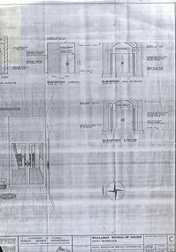
Plan - Building Plan, School of Mines: Administration Building Main Entrance, 22/09/1964
Photocopy of a plan produced by the Government of Victoria for alterations to the Main Entrance to the SMB Administration Building.ballarat school of mines, administration building, main entrance, lydiard street, a building, new classroom -
Stawell Historical Society Inc
Map, Section 4 (Taken from Plan No 959), 1894
Section 4 (Taken from Plan No 959)stawell -
Bendigo Historical Society Inc.
Map - STRUGNELL COLLECTION: BENDIGO GOLD FIELD GEOLOGICAL SURVEY, 1936
Bendigo Goldfieds Geological Survey. Prepared in the Bendigo Office Bottom Section of original map.Dept of Mines Victoriabendigo, gold mining, geological map -
University of Melbourne, Burnley Campus Archives
Plan, Swan Street Entrance. Also see B15.0352, 1988-1998
(1) 1 coloured and 2 copies, hand drawn , and 4 tracing paper sketches. Concept and Drawing by Steve Mullany, Lecturer V.C.A.H. Burnley, 09.12.1988. (2) 2 copies on tracing paper, original on paper with some additional notation and 3 copies of Landscape Plan by Steve Mullany 3 Feb 1989. (3) Photocopy of Project Eden, Swan Street, Richmond - Landscape Plan LA2 Project No 682 by Mark Mc Wha Pty. Ltd. Nov 1997. Includes Irrigation and Plant Schedule. (4) Coloured, Swan St Frontage Planting Scheme by P. Tulk for AMRAD 19.2.1998. -
 Ringwood and District Historical Society
Map - State Aerial Survey, Dandenong Ranges Area, Parishes of Warrandyte and Ringwood - 1956
Map of central and southern areas of Ringwood and part of Ringwood East and Heathmont compiled by Dept of Lands and Survey, July 1956, from aerial photographs and Cadastral Survey information. Subsequent hand-drawn addition of streets showing layout of "Township of Ballyduffy Estate 1858-60", an earlier proposed subdivision that did not eventuate. (See attached 5009b Ballyshanassy_ Melbourne’s lost suburb.pdf for Ballyduffy historical naming relevance). Ballyduffy Estate streets include City Road, West Prussia Road, Duffy Street, Ireland Street, Evans Street, Victoria Street, Regina Street, Short Road, Prussia Road, Duffy Street East, Ireland Street East, Evans Street East, Chapman Street. Misc Topo 93 Sheet 22, Ringwood A4B2. Scale: 4 chains to 1 inch. Contour interval 20 feet. -
 Bendigo Military Museum
Map - MAPS, BELGIUM WW1, 1912 - 1917
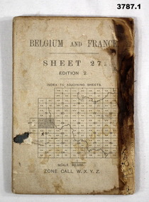
(.1) Areas covered on this map, Bollezeele to Poperinghe, Arques to Meteren. (.2) Areas covered on this map, BourBourg to Poelcapple, Reemilly to Armentieres. (.3) Areas covered on this map, Bruges, Neuzen, Ghent. (.4) Areas covered on this map, Alost, Loulain, Soignes, St Germain. (.5) Areas covered on this map, Roulers, Oosterzeele, Lille, Thoriecourt. Items relate to William Alexander No 502 AIF. Refer 3746.3 for his service details.(.1) Map, Belgium and France, sheet 27, Edition 2, scale 1:40,000, zone call W.X.Y.Z, Ordnance survey May 1917, gauze lined. (.2) Map, Belgium, Hazebrouck 5A, Edition 2, scale 1:100,000, Ordnance survey 1916, gauze lined. (.3) Map, Belgium, Ghent 2, scale 1:100,000, War Office June 1915. (.4) Map, Belgium, Brussels 6, scale 1:100,000, Drawn at War Office, Ordnance survey 1912. (.5) Map, Belgium, Tournai 6, scale 1:100,000, War Office Ordnance survey July 1912.(.1) On rear, “Glossary of terms”maps, belgium, france -
Bendigo Historical Society Inc.
Map - BENDIGO SHEET 4, Circa 1940's
Map: Bendigo sheet 4. Parish plan ( number 210 in Map Cupboard 1)map, bendigo, parish plan, bendigo -
Glenelg Shire Council Cultural Collection
Map - Map - Paper Survey, n.d
Paper survey map, ink and watercolour, framed under glass. Painted black gloss. Shows Fawthrop lagoon and surrounds including Fawthrop's home 'Windsor Cottage', outbuildings and garden, Cairncross and Howard holdings and othersBack: 'Town of Portland' -
 Melbourne Tram Museum
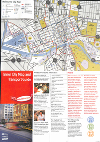
Map, City of Melbourne, "Inner City Transport Map", c1990
Map - 6 fold DL - full colour titled "Inner City Transport Map", providing information for Tourist Information centres, Metlink. Melbourne City Tourist Shuttle, and two maps, one provided by Melway giving a list of attractions. Published by City of Melbourne, Melway and Metlink with each of their logos.trams, tramways, map, public transport, city of melbourne, metlink -
Glenelg Shire Council Cultural Collection
Plan - Plans / Line Drawing Port of Portland Slipway Tuna Vessel 'Roza-S', c. 1986
Front: '24' - black texta, top right cornerport of portland -
Whitehorse Historical Society Inc.
Map, City of Nunawading Street and Block Map
City of Nunawading Street and Block map.City of Nunawading Street and Block map. Scale: 1:10,000. with enlargement, Canterbury Road South to Burwood Highway.City of Nunawading Street and Block map. canterbury road nunawading, burwood highway burwood east, city of nunawading -
Ballarat Clarendon College
Plan, Proposed new school building Mair Street, Ballarat for the Committee of the Clarendon Presbyterian Ladies College, March 1925. P S Richards, Coburn and Richards, ARVIA Architects
Clarendon Presbyterian Ladies College moved from a property on the corner of Clarendon and Armstrong Streets, Soldiers Hill to new purpose built premises in Mair Street, Ballarat in 1926. Framed under glassclarendon presbyterian ladies college -
Glenelg Shire Council Cultural Collection
Plan - Impression of the ultimate development of the Port of Portland, Ultimate Development of the Port of Portland, c. 1960
Donor's father was Shire Secretary at Hawkesdale and attended the opening of the Port.Impression of the ultimate development of the Port of Portland. Colour image on heavy, shiny white paper, white border round image. Folded in half.Front: 'Impression of Ultimate Development of the Port of Portland' - Printed in black, beneath colour image.port of portland -
Bendigo Historical Society Inc.
Map - TARNAGULLA, 8/08/1912
Map: Tarnagulla sheet 2. Parish plan ( number 241 in Map Cupboard 1)map, talbot, parish plan, tarnagulla -
Bendigo Historical Society Inc.
Map - BAGSHOT, November 1948
Map: Bagshot, County of Bendigo. Parish plan ( number 167 in Map Cupboard 1)map, bendigo, parish plan, bagshot, county of bendigo -
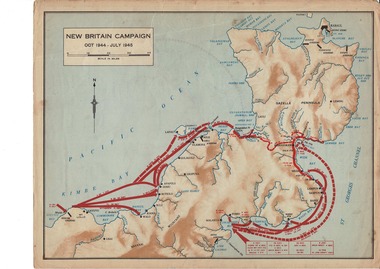 Lara RSL Sub Branch
Map, World War 2 Borneo Area, 1945
Military maps of Australian Campaigns in the Borneo area World War 2paper coloured maps from unknown bookMap 1 Centre section opened - North Borneo Campaign June - July 1945. Closed Side 1 - Tarakan Campaign 1 May - 21 June 1945. Side 2 Balikpapan Campaign July 1945 Map 2 Centre section opened - Aitape-Wewak Campaign Nov 1944 - Aug 1945. Closed Side 1 Bougainville Campaign Nov 1944 - June 1945 New Britain Campaign Oct 1944 - July 1945borneo new britain bougainville wewak maps ww2 -
 Bendigo Historical Society Inc.
Map - JACK FLYNN COLLECTION: TARNAGULLA SHEET 4, 25/11/1926
Map: Parish of Tarnagulla Sheet 4, Counties of Gladstone and Bendigo. Parish plan.Photo-Lithographed at the Department of lands and Survey, Melbourne by W. J. Butson. 25.11.26map, gladstone, parish plan, tarnagulla sheet 4 -
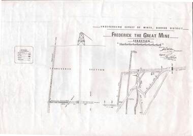 Bendigo Historical Society Inc.
Map - STRUGNELL COLLECTION: UNDERGROUND SURVEY OF MINES, BENDIGO DISTRICT, 7-1-99
Map, Underground Survey of Mines Bendigo District.Frederick the Great Mine, Sebastian. A collection of nine (9) maps of the mine, Signed H.S.Whitelaw Field Geologist 4.1.99 with some notes relating to same, including a: * Typed overview of the operation of the mine in 1912. * Clipping from Victoria its Mines and Minerals detailing the operation of the mine from its beginning in 1863 where it was first worked for alluvial. Charlton & Co., and Mr. Glass mentioned in article.A.S.Whitelawmap, bendigo, frederick the great mine -
 National Vietnam Veterans Museum (NVVM)
Map, Intelligence Map
Vinyl coated topographical map of part of Vietnam featuring main roads, towns and city locations current or ruined. River locations etc. Names all in Vietnamese language.map, vietnam -
 Eltham District Historical Society Inc
Map (item) - Sales Brochure, Plenty Township Estate and Bryn Teg Hill's Estate, Coghill & Haughton, Melbourne, c.1924
Plenty Township Estate "The rapid growth of Greensborough and the great traffic development on the main road between Heidelberg and Eltham augurs well for Plenty Township Estate. Already a Store, Post Office and State School have been started, and the activities of the Local Progress Association will help the district forward considerably. Within walking distance of the Montmorency and Greensborough stations." Bryn Teg Hill's Estate "Better known as "The Old Sand Hill, "within walking distance of the Montmorency and Greensborough railways stations." "Some few years back Mrs Thomas subdivided portion of the Sand Hill Paddocks, and the areas sold have been settled and many converted into charming outer suburban garden homes with cultivation and orchard plots. The south-eastern slope gives the land a grand outlook over the Yarra Valley on to the Dandenoings, and the are is very picturesque and homely." "A number of the blocks contain large deposits of valuable building sand, which should prove good speculation in view of the forecast for further rapid home development along the Eltham Suburban Electric Service." Sand Hills Road (Old Eltham Road) Date estimated as c.1924 - Electricification of railway line to Eltham referenced on map occured April 1923 and Mrs Mary Thomas died August 1925. Her home Bryn Teg became part of the Heidelberg Golf Club in 1927.The establishment of Lower Plenty as a suburban growth area supported by easy commuting facilitated by the elctrification of the Eltham railway linebonds road, bridge, bryn teg hill's estate, coghill & haughton, eltham road, heidelberg golf club hotel, houses, lower plenty, lower plenty bridge, lower plenty road, main road, plenty hotel, plenty river, plenty township estate, real estate agent, sales brochure, sand hills road, the old sand hill, sand hill paddocks, woodfull road, old eltham road, bryn teg, mrs m thomas -
 Bendigo Historical Society Inc.
Map - JACK FLYNN COLLECTION: BET BET SHEET 2, 17/09/1931
Map: Parish of Bet Bet Sheet 2. Parish plan.Photo Lithographed at the Lands and Survey Melbourne. 17.9.31map, gladstone, parish plan, bet bet -
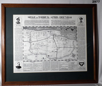 Bendigo Military Museum
Map - MAP, FRAMED TOBRUK, Post WW2
Wooden framed, glass fronted, green bordered, black & white map with history.“Siege of Tobruk April - Decr 1941 Cartography By James Emery History By Chester Wilmot”framed, maps, tobruk, passchendaele barracks trust -
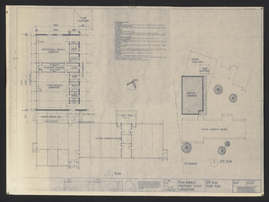 University of Melbourne, Burnley Campus Archives
Plan, VCAH Burnley Proposed Plant Laboratory, 1989
This must have been put out for tender. 1. Site Plan Floor Plan Job No. 89038. Drawing No. SKA001 by Godfrey and Spowers Australia Pty. Ltd. Scale 1:100, 1:200 X 4. 2. Proposed Laboratories & Offices at Swan Street, Richmond for VCAH-Burnley. College of Hporticulture: Floor Plan, Section A-A, Elevation 1, 2, 3 and $. Sheet No. 8952 WD2 by Fooks Martin Sandow Pty Ltd. Scale 1:100vcah, burnley, laboratory -
Bendigo Historical Society Inc.
Map - MINING PLAN, Circa 1880's
Mining Plan: showing the following companies: New Chum and Victoria Co., South Victoria Co., Lansell's 180, Victoria Quartz Mining Co.topic, mining, plans, mining in bendigo, new chum and victoria co., south victoria co., lansell's 180, victoria quartz ming co. -
Bendigo Historical Society Inc.
Plan - MARKS COLLECTION: PLAN GARDEN FRONT FORTUNA VILLA SANDHURST - G. LANSELL ESQ., JULY 3RD 1871
Plan for construction of Fortuna Villa, Sandhurst Title: Garden Front, Fortuna Villa, Sandhurst for G. Lansell Esq. Dated: 3rd July 1871 Coloured plan and elevation Condition: water damage and paper tears