Showing 119 items
matching board of land and works melbourne
-
![Newspaper Clipping - Digital Image, 2000 [pounds] for public open space 1965, 05/11/1965](/media/collectors/4f729f5697f83e03086015b8/items/5eb3933621ea670b94e21892/item-media/5eb3938a21ea670b94e2e147/item-fit-380x285.jpg) Greensborough Historical Society
Greensborough Historical SocietyNewspaper Clipping - Digital Image, 2000 [pounds] for public open space 1965, 05/11/1965
In 1965, the Board of Works advised Eltham Council that it had purchased 1 1/2 acres of land adjoining the Plenty River off Para Road zoned for public open space and offered the land to Council.An example of developments in the Greensborough area during the 1960sNews clipping, black and white text.shire of diamond valley, para road greensborough, melbourne and metropolitan board of works, plenty river, shire of eltham -
 Greensborough Historical Society
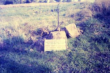
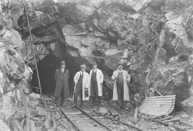
Slide - Photograph, John Ramsdale, Plenty Gorge sign: Slide 50, 1990s
Photograph shows a sign accusing MMBW of taking land for mega park - Plenty Gorge ParkPart of the John Ramsdale collection of slides and audio visual material.Colour photograph scanned from slide.No maker's marks. No caption on slide.plenty gorge metropolitan park, plenty gorge, melbourne and metropolitan board of works -
 Greensborough Historical Society
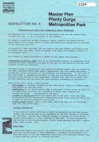
Newsletter, Melbourne & Metropolitan Board of Works, Master Plan Plenty Gorge Metropolitan Park, 1991_06
... The Parks Division of the Board was responsible...Melbourne & Metropolitan Board of Works... Plenty Lower Plenty melbourne The Parks Division of the Board ...The Parks Division of the Board was responsible for the preparation of a Master Plan for the management of the Plenty Gorge Metropolitan Park, comprising privately owned land and land owned by the Board and councils.The creation of the park by the Victorian government, to be managed by the Board of Works, guaranteed public access to a large area of land adjacent to the Plenty River Gorge.2p. newsletter, black ink on blue paperNewsletter No. 6plenty gorge park, plenty river -
 Glenelg Shire Council Cultural Collection
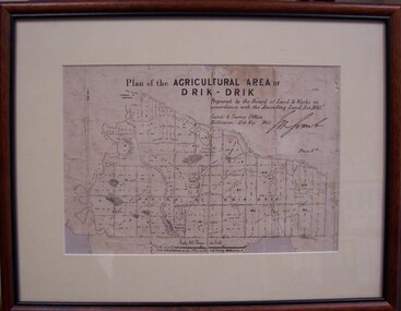
Map - Map of Drik-Drik, 1865
Displayed at History House.Print of map pasted onto board, mounted and framed under glass. Buff-coloured mount. Mahogany stained moulded wood frame, black inner frame.Front: Plan of the Agricultural Area of Drik-Drik L.2556/Prepared by the Board of Lands and Works in accordance with the "Amending Land Act 1865". Lands and Survey Office, Melbourne 11th May 1865. (printed, upper centre). Back: Duncan Hedditchmap, drik drik, plan, geography, cartography -
 Eltham District Historical Society Inc
Photograph, Entrance to Shire of Eltham Memorial Park, Garden Hill, Eltham-Yarra Glen Road, Kangaroo Ground, c.1923
View to south-east from Shire of Eltham Soldiers' Memorial Park showing the carriageway from the road to top of Memorial Park. Accompanying notes state that the entry gate was put in place in May 1921. Eltham and Whittlesea Shire Advertiser and Diamond Creek Valley Advocate Fri 21 May 1920 p 2 reported: Kangaroo Ground Memorial Park "It was decided to arrange for a working bee on Saturday, 29th inst., for the purpose of forming and gravelling the track leading to the Park, and of carrying out other necessary works." A history summary of the Shire of Eltham Soldiers’ Memorial Park • The summit at Garden Hill was a popular tourist lookout and picnic spot from the 1880s. Virtually the entire Shire of Eltham and beyond could be viewed from this location. • A local farmer, Mr Walter A. D. Wippell is credited as being the first to propose the idea of a war memorial park and offered £50 towards the purchase of the land. • The earliest public reference to this project is to be found in the local Advertiser newspaper edition of August 9th, 1918. A report of the August Council meeting records the Eltham Shire President, Cr. Robert White, saying: "some time back it was proposed that the Council obtain and place on an Honour Board in the Council Chamber [at Kangaroo Ground] containing names of the lads who had enlisted. Just recently however, it had been suggested that a more fitting memorial would be the obtaining of a piece of land on the summit of Garden Hill, Kangaroo Ground, and the formation of a memorial park in which a monument could be erected to represent the whole of Shire. If a couple of acres could be obtained a gentleman had promised to donate 50 pounds, and another one would fence it, and other contributions, he was sure, could be obtained." • Councillors were favourable of the proposal and the President, Shire Secretary and Shire Engineer were deputised to wait on Messrs Mess Bros. (the owners of the Garden Hill farm) and ascertain if they would gratuitously give the land. The Mess Bros. land adjoined the farm/stud of Mrs Fanny White (Cr Robert White’s mother), daughter of Andrew Harkness who established their property on Garden Hill around 1846. • Access to the land came in February 1919 when several Councillors and the Shire Engineer surveyed the actual two acres of '5 chains along the road and 4 chains deep'. The Engineer volunteered his services free to do this task. The Mess brothers however demanded £100 per acre but eventually agreed to take £50 per acre. • Entry from the Kangaroo Ground-Yarra Glen road was seen to be a problem and Mrs. White, who owned the land beside the park, was asked to donated a triangle of her property to allow this access. • By September 1919 returned soldiers were employed by the Shire and volunteers were called to clear the hilltop by ploughing up the rocks and clearing the area, the fencing was put into place and in May 1921 the Council erected three gates, within an archway, at the entrance to the drive and pathway to the summit. • Public subscriptions were sought through the Advertiser newspaper to beautify the site. The views of the Curator of the Melbourne Botanical Gardens were sought as to the ‘class of ornamental trees most suitable for planting in the Park area”. • The Memorial Park or Shire of Eltham Soldiers’ Memorial Park was officially opened by Mr. W.H. Everard, M.L.A., 3 September 1921. • In 1922 plans were made to place a War Memorial in the Park. Funds were donated by the Council of £250 and a challenge to the community, to match this money with contributions was met. • On Anzac Day 1923, 1,000 people gathered on the summit in the park for a memorial service. A much smaller group of about 50 people gathered around a newly constructed cairn and flagstaff in the afternoon of Anzac Day 1924 amidst rain and a squally southerly wind, the morning service being cancelled. • A meeting for those interested in establishing a War Memorial monument within the park was held in January 1924 and the Eltham Shire War Memorial League was formed and a design competition decided upon. • The Shire of Eltham War Memorial tower was built in 1926 at a cost of £1,023 and 5 shillings with locally quarried stone donated by Dr Ethel and Professor William Osborne. It was formally known as the ‘Shire of Eltham War Memorial’ and was unveiled on 11 November 1926. The large bronze inscription above the entrance to the tower states: SHIRE OF ELTHAM WAR MEMORIAL THESE MEN DIED FOR THEIR COUNTRY 1914 IN REMEMBRANCE THIS TOWER WAS BUILT 1918 • The Caretaker’s hut was built in 1927 with left over from the tower construction. • A returned soldier was appointed to act as caretaker for the memorials. Tiny Carrol, a huge man, was the first caretaker and lived in the stone hut. There was a push to have alterations made at one stage to provide additional rooms for a married caretaker but was rejected. • A new Caretaker Cottage was built in 1951 at a cost £2,500. The cottage had been subjected to raids by thieves three times during construction until a guard from the Returned Servicemen’s League was posted until its opening. • The War Memorial tower was re-dedicated by Sir Dallas Brooks on 8 November 1951, unveiling new bronze plaques containing the names of those who fell during the Second World War. Sir Dallas also officiated the opening of the new Caretaker’s Cottage. • A toilet block was built in 1965. • A further dedication of the Shire of Eltham War Memorial tower took place 11 November 2001 to recognise the men who fell in subsequent campaigns up to and including Vietnam. • Four land titles are involved: o The purchase of the two acres from owners Ruth Gosling, Alexander Mess, James Johnson Mess and Joseph Mess is recorded in two actions, the first being the payment of £100 for the two acres, the second showing that the Shire of Eltham did not get a transfer of title until 14th January 1952. o The access land donated by Mrs. Fanny White is dated 26 February 1924. A further need to widen the entry came after the deepening of the road cutting and another land donation was given by Sir Herbert Gepp, title dated 15th May 1952. This would have been about the time he sold off the former White ‘Garden Hill’ property. o The land reserve to increase the area and possibly allow a circuit road to be put in place on the western side of the park was purchased by the Shire of Eltham, title dated 16th February 1973. Rare photograph of the entrance to the Shire's Memorial Park during early stages of development prior to the erection of the Shire of Eltham War MemorialSepia photograph printed with white border with slight crack lower left hand corner and three significant vertical cracks fanning from lower centre edge to upper edge Digitally enhanced version to minimise impact of crackseltham-yarra glen road, entrance gate, garden hill, kangaroo ground, shire of eltham memorial park, shire of eltham war memorial, kangaroo ground war memorial park -
 Eltham District Historical Society Inc
Document, Notice of Decision to Grant a Permit; Ref: E94/306 - Subdivision of 30-34 Diosma Road; 16 November 1994, 16/11/1994
... melbourne metropolitan board of works... of objection melbourne metropolitan board of works planning application ...This permit was eventually overturned following community objection and the land was donated by Yarra Valley Water for use as a community reserve.The Stokes Orchard Estate collection is typical of housing developments of the late 1970s and 1980s. It was one of the earliest estates in Eltham following the nearby Woodridge Estate development.A4 document consisting of ten pagesAs notedstokes place, eltham, stokes orchard, stokes orchard estate, streets, houses, peter and carla vermey, diosma road, letter of objection, melbourne metropolitan board of works, planning application, reservoir, shire of eltham -
 Federation University Historical Collection
Document, Zelda Martin, Central Victorian Goldmining towns - Boom Towns or Ghost Towns?, c1996
... to the Honorable Chief Commissioner of Public Works, Melbourne re the mode... Works, Melbourne re the mode of carrying the sludge from ...Zelda Martin was a PhD candidate at the University of Melbourne.[.1] 4th item in light blue display book titled Research Approach/Overview of Chapters/Confirmation of Canditure/Chapters1,2,3&4 of proposed thesis. *Twenty-seven page article on Victorian goldfields towns titled: Central Victorian Goldmining Towns - Boom Towns or Ghost Towns. The article was written during the author's PhD study. It outlines the context methodology, and resources and the chapters of the proposed thesis: (1) Central Victorian Goldmining Towns - The Context (2) Contemporary Views of the Factors Necessary for Town Growth (3) Outward Manifestations of Town Growth (4) The Trappings of Government (5-9) The Main Towns and Their Hinterland. [.2] 5th item in Light Blue display book as above item. *Chapter 1 of proposed thesis titled 'Pick, Shovel and Tin Dish Mining.' Covers in Section A: Central Victoria - Pre 1851: Aborigines in Central Victoria, Squatters, and Government. Section B: The years 1851-1854: The Early Gold Rushes, Government Reaction, Township Surveys, Legislation, Town Development, Local Government and Early Settlement. [.3] 6th item in Light Blue display book as above item. *2A of proposed thesis titled 'Contemporary Views of the Factors Necessary for Town Growth'. Similar information to Chapter 1 plus extra re towns and maps. Sections: Introduction, Context of Place - Geographical Towns Listed, The Context of Time - Pre1851 Aborigines, Governance of Port Phillip, The Squatters, The Villages of Central Victorian Highlands, Conclusion, Condensed Version of Chapter2B. [.4] 7th item in Light Blue display book as above item. *Chapter2B of proposed thesis. Sections: Area of Research, Schools, Banks, Newspapers, Progress Association, Town Development - Sandhurst (Bendigo), Ballarat, Castlemaine,, Maryborough, Ararat and Stawell. [.5] 8th item in Light Blue display book as above item. *Chapter 3 of proposed thesis titled 'Outward Manifestations of Town Growth'. Sections: Introduction, Contemporary Writing, Educationalists, The Bankers, The Townsfolk, Current Theory, General Theories of Urban Development, and Conclusion. [.6] 9th item in Light Blue display book as above item. *Chapter 4 of proposed thesis titled 'Trappings of Government' Sections: Introduction, Early Government Attitudes to Mining and Town Development, Law and Order, Township Surveys, Legislation, Local Government, Transport and Communication, The People and Lobbyists. [.7] 10th item in Light Blue display book as above item. *'The Rise and Fall of Central Victorian Goldmining Towns'. Includes a map showing main Goldfields, a table showing towns and villages at two points in time - 1857 and 1871; a Bibliography of Primary and Secondary Sources. [.8] Resource No1. Black display book titled Local Towns 1 : Alma: *Brief history *Directory *Maps Amphitheatre / Mountain Hut: *Brief History Post Office Directory Ararat: *Brief History *Post Office Directory 1869 - Alphabetical Listing by Occupation *Ararat - Prominent Citizens of 1858 *Langi-Morgala Museum Avoca: *Brief History *Excerpts from 'Avoca The Early Years', Margery and Betty Beavis; pg1 - Beginnings; pg11 - The Midas Touch; pg25 - Local Gold Escorts; pg27 - A Town is Born; pg51- The Administration of Justice; pg53 - The Ways of the Law; pg61 - News of the Day; pg65 - A Time to Play; pg72 - Land Ownership *Post Office Directory (Bailliere's) 1869 *Tourism Map and Information of area *Historic Avoca - A 5.5km Tour *Avoca & the Pyrenees Region - information pamphlet Ballarat: *Early History of Ballarat - Ballarat Historical Society, Publication No.1: origin of the name; Ballaarat - the Beginning; Fabulous Yields from the Ballaarat Goldfield; *Streetscape Lydiard Street. *Hand drawn map showing Leigh River, Old Portland Bay Road, plaque on road to Colac; etc. *Newspaper article re 'The Theatre Royal' ( which stood in the vicinity of the current Owen Williams store) - 'The News'15/04/1998 *Article - 'Ballarat's Mechanics' Institute Lives On' Ballarat Courier, 14/09/1985 *Article - Standing the Test of Time' The News 17/11/1993 re The Mechanics Institute & picture of the Reading Room *'Ballarat a Study of a City, Phyllis Reichl, pub. Nelson, 1968; no.3 place, time and people field studies series *Investigator Vol.33 No.2, 1998 Geelong Historical Society. Article on pg75 describes Ballarat in 1861 *Folded poster - 'Ballarat 100' a history of telegraph communication, pub. Telecom. Beaufort (Fiery Creek): *Brief history *Post Office Directory [.9] Resource No.2 Black Folder Titled Towns cont.No2 Bendigo (Sandhurst): *'Family & Local History at the Bendigo Library - 1851-2001 150 years of gold'. *Bendigo Government Camp in 1853 illustration; key to sketch and names of Government officers stationed there *Excerpts from 'Bendigo and Vicinity' Adolph Haman *The Bendigo Goldfield Registry - pgs 1-7 Introduction *Excerpt: 'Breaking the Grip' *Excerpt: The Most Go-Ahead Place *Excerpts from 'History of Bendigo' - anti license agitation; laying out of town; proposed railway; gold calls and dividends; the Sandhurst Municipality; journalism *Bibliography Blackwood: *Excerpts from 'Aspects of Early Blackwood - The Goldfield, the Landmarks, the Pioneers' Alan J Buckingham and Margaret F Hitchcock, JG Publishing,1980 Buninyong: *A Brief History *Investigator Vol1 No.2 Feb 1966 Geelong Historical Society. Pg3 - Article re gold escort route - Mt Alexander to Adelaide - (see a simple monument on the Western Highway a few miles out of Horsham. Pg 15 - Ballarat Excursion - re the finding of gold. *Three articles published by Buninyong and District Historical Society Inc: (Magpie Exploration; Finding Gold In The Green Hills; Magpie Exploration; Burnt Bridge to Cargarie to Mt Mercer) *Copies of newspaper articles/items *Buninyong Street Directory Carisbrook: *In the Beginning There Was Carisbrook *The History of the Carisbrook Racecourse Carngham / Snake Valley: *Brief History *Directory Castlemaine: *Directory 1865-1866 - Alphabetical and Street *Poster - Castlemaine A Contemporary Guide "The Great Centre" 1866 - A Contemporary Guide to the Fascinating Past *Pamphlet - Castlemaine District Community Hospital *Map - Castlemaine, Maldon & Surrounding Districts *Map and Information - The Dry Diggings Track - a 55kl walk among historic goldfields relics ( Castlemaine Fryerstown Vaughan Mt Franklin Hepburn Daylesford) *Postcard - Former Court House *Directory 1867 - Alphabetical, Trade [.10] Resource No.3 Grey folder Titled Towns 3 Creswick to Maryborough Creswick: *Brief History *Booklet - "Creswick Cemetery Walk" *Booklet - The Buried Rivers of Gold Heritage Trail Creswick *Creswick Historical Museum Information Sheet *Chronological History of Creswick *Alphabetical Directory of the Borough of Creswick *Creswick's Creek Directory 1856 *Historic Creswick Walking Tour *A Brief Account of the Schools of Creswick - Past and Present *100 Years of Railway Travel in Creswick *The Berry Deep Leads *The Spence Home at Jackass Gully in the Creswick State Forest ( William Guthrie Spence - Pioneer) *The New Australian Mine and the 1882 Disaster *Creswick District News, Issue 7, July August 1999 *The Creswick Miners Walk - Information and Map *Maps Chewton: *Brief History *Directory Clunes: *Brief History *Clunes Street Directory Daylesford: *Brief History *Notable Bushfires in Daylesford District Over More Than a Century - "Black Thursday" 1851; 1862; 1899; the Disastrous Hepburn Fire of 1906; 1939; 1944; 1969. *Post Office Directory -Daylesford and Hepburn Dunolly / Inkerman: *Brief History *Directory *Pamphlet - Goldfields Historical Museum *Pamphlet - Historic Dunolly - Victoria's Best Kept Secret *Map of Gold Workings at Dunolly Area - showing where the main gold rushes occurred *Brief History - Inglewood *Directory - Inglewood - Name Occupation, Dwelling Kingower: *Brief History *Directory - Name / Ocupation / Dwelling Linton / Happy Valley / Piggoreet: *Brief History *Directory - Lintons McIvor: *"A History of the Shire and the Township of Heathcote" by J.O. Randell Majorca: *Brief History *Official Post Office Directory 1869 - Name / Occupation/ Address Maldon (Tarrangower): *Brief History Part 1 *Brief History Part 2 *Post Office Directory *List - Alphabetical Order by Names plus Business and Trade (Tarrangower Times Oct/1858) *List - Alphabetical Order by Trade plus Name and Business *Directory - Name / Occupation / Dwelling Maryborough: *Worsley Cottage - built by Arthur Worsley, a contractor in stonework in 1894 [.11] Resource No. 4 Blue Display Book titled Towns 4 Moliagul to Stawell Moliagul: *Brief History *Moligul Legislative Assembly (Voting?) List - Names and Occupations *Moliagul Victorian Post Office Directory 1868 - Name / Ocupation / Address / Comments *"The Welcome Stranger" gold nugget *The Sunday School *The Welcome Stranger Discovery Walk - information and map Moonambel (Mountain Creek) Redbank *Brief History *List of names extracted from advertisments of the Pioneer and Mountain Creek Advertiser 16/02/1861. *Bailliere's Directory 1869 - Alphabetical List of Name / Occupation / Place St Arnaud: *Brief History Sebastapol: *Brief History *Directory 1869 - Alphabetical by Name; plus occupation and address. Browns and Scarsdale: *Brief History *Browns Street Directory - Name and Occupation Smythesdale: *Brief Description *Smythesdale Street Directory -Name and Occupation Stawell (Pleasant Creek) *Brief History *Victorian Official Post Office Directory - Name /Occupation / Dwelling *Chronology - 1841-1920 *Production of gold statistics - 1879 - 1900 *Big Hill *Extracts from "The Golden Years of Stawell". Chapt 1 - Stawell's Coming Out. Capt. 2 - The Gold Rush. Caapt.3 - Cradle of Democracy. Chapt.4 - The Reefs Becomes Stawell. Chapt. 5 - Rushing In. Chapt.6 - The Pioneers. Chapt 7 - The Decade of Optimism. [.12] Resource No. 5: Blue Display Book titled 'Towns Steiglitz to the The Golden Triangle. Steiglitz: Brief History Victorian Post Office Directory 1869 *Map of Steiglitz *List of maps relevant to Steiglitz history *Information 6 tables of data from "Reports of Mining Surveyors Talbot (Back Creek) Brief History Taradale: Post office Directory 1869 - Name/Occupation/Street. Also list in alphabetical order by Occupation Taradale *Chronological Reference to Taradale Mines *Water - The Coliban System of Waterworks *Joseph Brady *The Syphon Tarnagulla (Sandy Creek) *Brief History *Tarnagulla Businessmen Cameos to give depth to advertisments in 'The Tarnagulla Courier' various issues 1864-1871 *Directory - Name/Occupation /Address *List - Name/Business/Trade Wedderburn (Koorong) *Brief History *List - Name/Occupation The Golden Triangle: *The Early Rushes - Wedderburn / Moliagul / Sandy Creek - Tarnagulla / Jones Creek - Waanyarra / Kingower / Dunolly - Goldsborough / Inglweood *Census of 1857 - Population / Occupations *1858-1871 - A Time of Consolidation- Wedderburn / Moliagul / Sandy Creek- Tarnagulla / Arnold *Census 1871 - Population *Information gleaned from the census data - Demographics / Population / Occupations / marital / Birthplace / Religion / Literacy/ Occupation and Housing Cameos *Graphs - Birthplace of settlers /Male-Female Ratio / Married males / Children under 15 as Percentage of Population / Religion *Census 1857 - Statistical data *Maps *Bibliography [.13] Resource No. 6 - Black Display Book Information and Research in Central Victoria including: *Banking - Research from ANZ Bank Archives *Institutions - also includes articles listed from the Ballarat Times Newspaper *Australian mining History Association - A.M.H.A. Bibliography *Australia's Mining History * Bibliography - Land Surveys Victoria - *1853 Administration (Statistics and Other) includes: schools / ministers of religion / police / military / local administration / licences for sale of spirits / distances between various Victorian gold fields. * Victoria Government Gazette (Copy) - N0. 116, 12/12/1854 includes: Gold Felds Commission of Enquiry & No. 85, 15/09/1854 - Addresses presented to the Lieutenant Governor (Sir Charles Hotham) during his tour through the Gold Fields of Victoria,1854. Addresses on behalf of : the people of Bendigo; Members of the Church of England, Bendigo; Members of the Wesleyan Church on the Bendigo Gold Fields; Bendigo Gold District General Hospital; the Bendigo Prospecting Association; Committee of the Bendigo Local Exhibition; Bendigo District Medical Association; Coloured Americans Resident at Bendigo; German Inhabitants of Bendigo; Landowners, Inhabitants, and Miners of Castlemaine; Inhabitants of Forest Creek; Inhabitants of Heathcote and Gold Miners of McIvor; Residents and landholders of the District of Bacchus Marsh; Inhabitants of Kilmore and Vicinity. *Gold Fields Correspondence 1853: letter from Lieutenant Colonel Valiant, (Officer commanding the Troops in Victoria) to the Lieutenant Governor re threatened disturbance at Sandhurst (Bendigo) regarding the Gold License Fee. * Extracts from a book "Victoria" re Gold Fields Commission of Enquiry involving mainly Ballarat and Castlemaine and a chapter titled 'A Tour to the Victorian Gold-Fields' *Lists of central Victorian newspapers - listed by date published 1851to 1874; by first date available to State Library. *A list of cities and towns showing County, population in 1861 &1871, and municipal status. [.14] Resource no.7. Black display book. *Reference: Papers presented to Parliament Victoria - 1859-1860 4 volumes - relevant sections copied. Contains information on Branches of Government. General / Finance / Gold / Gazette / Commission and Warrant / Statistic. *Gold Fields Act. In accordance with the Act the gold fields are divided into six districts - Ballaarat, Castlemaine , Sandhurst, Avoca, Ararat, and Beechworth.. Official staff in each gold district consists of a Resident Warden, Wardens, Wardens' Clerks, Bailiffs, Chinese Protectors, Chinese Interpreters, and Mining Surveyors. *Gold Receiver *Gaols *Police magistrates and Clerks of Petty Sessions, etc. *Field Branch *Immigration and Emigration Overland - Chinese - 1859 *Population on the Goldfields *The Geological Survey - The Government Geologist is assisited by staff from four branches - the office Branch; the Publishing Branch; the Field Branch and the Museum Branch. *Commission to Enquire Into Sludge dated 10/02/1859 (Some sections copied) - Report to the Honorable Chief Commissioner of Public Works, Melbourne re the mode of carrying the sludge from the puddling mills in Sandhurst without interfering with the drainage of the town and the roads in the neighbourhood. [.15] Resource No.8: Camel display book titled Resource No. 8. Aborigines *Lists of book titles - +"Readings in Victorian prehistory" +"The Aborigines of Port Phillip" +Aboriginal languages and clans" +"A History of the Port Phillip District" +"Langi Ghiran 1: Aboriginal Rock...." +"Koorie History: sources for aboriginal studies in the State Library of Victoria", ed. Tom Griffiths, Melb. Friends of the State Library, 1989 +"The Public Lands of Australia Felix"; settlement and land appraisal in Victoria1834-91 with special reference to the Western Plains", J.M.Powell, Melb. Oxford University Press 1970 +*Bibliography of the Victorian Aborigines' from the earliest manuscripts to 31st December 1970, Massoa, Aldo, Melb. Hawthorn Press, 1971 +"Aborigines in Colonial Victoria, 1836-1886", M.F. Christie, Sydney University Press, 1979 +"Urban and Industrial Australia: readings in Human Geography" ed J.M. Powell, Melb. Sorrett Pub. 1974 *Extracts: -Processes of Pioneer Settlement - The Squatting Occupation of Victoria, 1834-60. J.M. Powell -Areal Variations in the Class Structure of the Central-Place Hierarchy. P. Scott - Volume1 and Volume 2: Notes Relating to the Habits of the Natives of Other Parts of Australia and Tasmania. Compiled from various sources for the Government of Victoria by R Brough Smyth. John Curry, O'Neil, Melb. 1st pub. Melb. 1876. p31-45 - Numbers and Distribution of the Aborigines in Victoria -Victorian Aborigines 1835-1901 - A Resource Guide to the Holdings of the Public Record Office, Victoria; published by the Government Information Centre 1984. *History of the Aboriginal Artefacts Displayed in the Daylesford Museum. F. G. Powell (4 page pamphlet) *Letter to Zelda Martin from Peter Lovett, Cultural Officer, Ballarat & District Aboriginal Co- Operative, 05/02/1997 *Map: Ian Clarke Victorian Tribunal Boundary Map - Clans of Central Victoria. *Victorian Rock Art and Mythology - Article about Mount Langhi Ghiran and myths of the Tjapwarong people. *Two Aboriginal myths relating to the Grampians - 'The Monster Emu' / 'The Aquisition of Fire', by the Aborigines in the Grampians Areas *Article titled (chapter 8) Ballarat - information re camping sites in the region. Lake Wendouree / Lake Burrumbeet (includes a myth) / Mt Bunninyong / Lal Lal / Pitfield / Mount Elephant / Mount Egerton / Meredith / Lake Goldsmith / Lake Learmonth / Ercildoune *Notes on the Aborigines of the Wider Ballarat Region plus European names=Aboriginal names. John Morris 26/07/1995 *Role of Aborigines in Town Development in Central Victoria. Mentions Native Police Force est. in Port Phillip 1842 and Central Board for Aborigines est. 1860 *The Grave of King Billy. (Frank Wilson) Pamphlet. *Camping Places in Central and Northern Victoria. Article re Lake Burrumbeet site. *Programme for the Unveiling of Memorial Cairn for Edward Stone Parker 1802-1865. Note portrait not accurate. Accurate portrait is available in the book "A Successful Failure A Trilogy The Aborigines and Early Settlers", Edgar Morrison, Graffiti Publications, 2002. * Large envelope addressed to Mr G Netherway containing newspaper cuttings regarding the life of Edward Stone Parker, the unveiling of the Memorial Cairn as mentioned above, articles titled 'Episodes from Our Early Days' (Edgar Morrison, Yandoit)- The Black's School, A School At Last and The Final years. Also a typed page titled 'Historical Background to E.S.Parker's Career. Includes an interesting tale titled 'When the cat lay doggo' re laying power leads for the unveiling ceremony at the memorial site. [.16] green display folder titled 'Research Aids' *List of references to Commissioners' & W'ardens' Reports (formerly held at La Trobe Library Archives, now at Public Records Office [PRO]). Indicates town referred to / date of report / name of camp if different to town. * Archive information re Anglican Records *Movement around the Goldfields - Miners and Storekeepers - usefulness of newspapers in providing information - areas covered - Castlemaine, Maldon, Ararat, Stawell, Tarnagulla, Dunolly. *Port Phillip /Victoria Directories 1839/1867 - Chronological list of Directories included in this series. *"Notes on the History of Local Government in Victoria" A.W. Greig Melb. University Press 1925 - Photo-copied extract p5-p40. (Source - Deakin University Library) - Introduction by W.Harrison Moore. Section 1 - Development in New South Wales Before Separation. Section 2 - Development in Victoria After Its Separation from New South Wales. Hand written notations: 'roads, markets, and local government 1855 on' ;'opportunity of squatters in parliament' and 'opportunities of matters in parliament p33' * Notes on the Establishment of Surveyor General's Department 1851and Commissioner of Crown Lands and Survey. * Newspaper articles from The Argus, 1849, re the discovery of gold in the Pyrenees region. * Excerpt - a report on schools - A.B.Orlebar, Inspector; re the need for permanent school buildings rather than tents. *Excerpt from - 'Approaches to Urban History', Sean Glynn: The Case for Caution * Except from - 'The Urban Sprinkle', Weston Bate: Country Towns and Australian Regional History *Reference- 'The History of Land Tenure in the Colony of Victoria', John Quick. References the Haines Land Bill, land tenure and Land Leagues. [.17] Light blue envelope folder titled 'Birtchnell's Ballarat, etc. Directory 1862 *Contains various directories for Smythesdale, Buninyong, Clunes, Brown's and Creswick. [.18] Red envelope folder no.2 titled Victorian Gazetteer *Selected pages from 1869 Victorian Gazetteer on A4 paper (with a handwritten note questioning if some pages are from 1868 Victorian Gazetteer as appears to be different sizes - A3 pages.) Information includes locations and descriptions of towns, hotels, banks, communications and populations. (Does not include names, residences and occupations) [.19] Red Envelope folder titled Bailliere's Official Post Office Directory 1868 (or1869 or a mixture of both?) *Preface *Contains a selection of pages of towns highlighted in yellow in the the index *Work on this directory was commenced in 1867. *Information includes: Municipalities - mayors and councilors; lists of towns naming male inhabitants and their occupations. [.20]Yellow manila folder titled Post Grad Seminar Presentation 1996 *Gives some background to Zelda Martin's proposed thesis and why she chose the topic Gold Mining Towns Boom or Bust [.21] A3 display book - No. 1A * A list of 'Relevant Newspapers collected: The Tarrangower Times and Maldon Advertiser (first published 1858) Includes dates 1858-1867. The Mount Alexander Mail. Includes dates 1854-1866 The Tarnagulla Courier. Includes dates from1864-1871 Dunolly and Burnt Creek Express. Includes dates from 1862-1871 * Selection of newspaper pages from The Mount Alexander Mail 1854 to 1856, mostly showing advertisements for businesses and services provided to that community. [.22] A3 display book - No. 1B * Selection of newspaper pages from The Mount Alexander Mail 1857 to 1866, mostly showing advertisements for businesses and services provided to that community. [.23] A3 display book -No. 2 * Selection of newspaper pages from The Tarnagulla Courier 1864 to 1871, mostly showing advertisements for businesses and services provided to that community. [.24] A3 display book - No. 3 *Selection of newspaper pages from The Tarrangower Times (and Maldon and Newstead) Advertiser 1858 to1867, mostly showing advertisements for businesses and services provided to that community. [.25] A3 display book - No.4 * Selection of newspaper pages from The Dunolly and Burnt Creek Express; and The Dunolly and Betbetshire Express 1862 to 1871, mostly showing advertisements for businesses and services provided for that community. [.26] A3 display book - No.5 Includes: * Bryce Ross's Diggings Directory. Includes instructions for using this directory. This directory was used by "all persons having connexion or desiring to communicate with 'working parties, private friends, or Stores at the Diggings." As a directory for each area wwas completed it was published in each month's issue of Bonwick's "Digger's Magazine." Years c1852/1853. This Directory commences first at the head of Forest Creek. Includes a directory for Bendigo and Ballarat. Of interest at the end of the Bendigo and Ballarat directory is a list of the number of storekeepers, butchers, doctors, smiths, eating houses, lemonade sellers and chapels. * The Castlemaine Directory and Book of General Information Comprehending Glass's Model Calendar for the Two Years 1862 and1863. "zelda martin, victorian goldfield towns, bendigo, castlemaine, ballarat, maldon, stawell, ararat, maryborough, creswick, avoca, heathcote, banks, bank of australasia, union bank of australia, government camp, sandhurst, water supply, tarnagulla, talbot, back creek, mountain creek, police court, carisbrook, dunolly, thompson's foundry, charles clacy, anthony trollope, robert cecil, mount alexander, urbanisation, national schools, education, govenrment, industry, railway, transport, settlement, land settlement in central victoria, steiglitz, joseph brady, the new australian mine, berry deep leads, william guthrie spence, creswick state forest, arthur worsley, worsley cottage, the welcome stranger, moliagul, moonambel, redbank, st arnaud, sebastapol, brown's, scarsdale, clunes, chewton, daylesford, bushfires, inkerman, inglewood, kingower, lintons, happy valley, piggoreet, mcivor, majorca, tarrangower, taradale, the coliban system, the syphon, sandy creek, wedderburn, koorong, arnold, jones creek, waanyarra, the golden triangle, census 1857, blackwood, buninyong, durham lead, magpie, carngham, snake valley, alma, amherst, daisy hill, amphitheatre, mountain hut, beaufort, fiery creek, counties, population, gold fields commission of enquiry1854, william westgarth, gold license fee, lieutenant colonel valiant, administration of the victorian gold fields, commission to enquire into sludge 1859, e.s. parker, edward stone parker, edgar morrison, mount franklin protectorate, dja dja wurrung, memorial cairn, franklinford, mt franklin memorial cairn, jajowurrong, dja dja wurung, tjaowarong, wothowurong, assistant protectors, daylesford museum, buluk, rock art - grampians, aboriginal mythology - grampians, aborigines, first nations people, mount franklin, aboriginal artifacts, lake burrumbeet, native police force, central board of aborigines, yandoit, commissioners' reports, wardens' reports, port phillip/victoria directories 1839-1867, local government - victoria 1853/1854, surveyor general's department - 1850's, victorian schools 1850's, a.b.orlebar, haines land bill, william charles haines, wilson gray, land tenure, land leagues, victorian gazetteer, the tarrangower times and maldon advertiser - 1858-1867, the mount alexander mail 1854-1866, the tarnagulla courier 1864, dunolly and burnt creek express 1862-1871, bryce rose's diggings directory, the castlemaine directory 1862-1863 -
Glen Eira Historical Society
Letter - Glen Huntly Road, Elsternwick
... Melbourne Metropolitan Board of Works... Ingleby June Elsternwick Chamber of Commerce Moore H. R. Melbourne ...Ten documents concerning the redevelopment of 543-555 Glenhuntly Rd., Elsternwick in the early 1980s by B. P. Food Plus to create a 24 hour drive-in convenience store. Includes newspaper articles and correspondence from local residents, small business and community groups stating their objections and concerns. Also a report by the MMBW, 1982, on the development of guidelines for such shops.town planning appeals tribunal, de silva m., de silva m. a., b. p. australia ltd., city of caulfield, riley john, buckner john, wright h. mcm., cook r., burleigh brian, caulfield progress association, wilson lawrence john, murphy barry oliver, messrs. whiting and byrne solicitors, messers t. j. mulvaney co., mckimm russell, robinson g. a., watt h. w., kinder alan, commercial development, white o. a., van hoon joan, van hoon john, smith p., ben s. g., lee g. b., gibbs les, brennan h. p., pretty f. w., rasmussen l., orchard a. r., lopek m., carpenter mrs., pearce mrs., mcgrowan e., owens p., brawn j. e., harron g., brittingham w. c., lindsey m., de silva s., horton mary, james m., walker e., bennett h. l., riley s., b. p. food plus, coltex, glen huntly rd., hopetoun gardens, pickerd c. w., doolan g. n. (cr), the retail confectionary and mixed business association, town planning, land values, peak susan, white ted, ingleby june, elsternwick chamber of commerce, moore h. r., melbourne metropolitan board of works, ‘convenience premises and convenience shops report and guidelines’, legal documents, hawthorn road, petitions, north road, petrol stations, hopetoun hospital, foster street, winton hall (special accommodation home), caulfield council, resident action, murray street, councils -
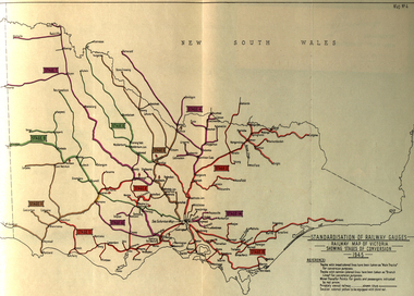 Federation University Historical Collection
Book, Standardization of Australia's Railway Gauges, 1945, 1945
... . As Director-General of Australia's Land Transport Board, he presented.... As Director-General of Australia's Land Transport Board, he presented ...Sir Harold Winthrop Clapp KBE (7 May 1875 – 21 October 1952) was a transport administrator who over the course of thirty years had a profound effect on Australia's railway network. In two decades as its Chairman of Commissioners, he revolutionised Victorian Railways, with unprecedented attention to customer service and innovations such as more powerful locomotives, air-conditioned carriages, and faster services culminating in the introduction of the flagship Spirit of Progress express train. Seconded to the Federal Government in World War II, he played a pivotal role in the manufacture of fighter aircraft in the defence of Australia. As Director-General of Australia's Land Transport Board, he presented a report on railway gauge standardisation that ultimately led to the eventual linking of all Australian mainland capital cities by a uniform rail gauge. (http://en.wikipedia.org/wiki/Harold_Winthrop_Clapp, accessed 02/10/2013)Grey, soft covered, stapled report of 89 pages. "Standardization of Australia's Railway Gauges" by Harold Clapp is a report and recommendation regarding the standarization of Australia's railway gauges. The contents include: * Lines suggested for conversion or new lines to be constructed * scheme of conversion of tracks and structures * scheme of conversion of locomotives and rolling stock * Estimated costs * Associated works * Estimated manpower which the project will absorb in its various phases *Standardization of rolling stock * Other considerations associated with the project * Estimated time involved in the various phases of the work. The report includes 8 maps: * Map of Australia showing the various proposals referred to *Map of Australian railways showing extent of standard gauge if proposals are carried out * Map of Australian railways as of 30 June 1944 *Map of Australia showing principal mileages referred to in the report * Railway Map of Western Australia, 1945 * Railway Map of South Australia, 1945 * Railway Map of Victoria, 1945 * Railway Map of Melbourne Suburbs, 1945 railway, guage, standardization, standardisation, fremantle, perth, kalgoorlie, peterborough, silverton, tramway, tram, train, townsville, dajarra, bourke, cunnamulla, charleville, blackall, longreach, winton, hughenden, townsville, gajarra, birdum, darwin, narrow gauge -
 Flagstaff Hill Maritime Museum and Village
Document - Plans, Lighthouse Keeper's Quarters Warrnambool, 1858-1909
... Warrnambool’ (2375.01)* Public Works Office Melbourne – Front and Back.... They originate from Public Works in Melbourne. Seven were drawn in 1858.... Public Works Office Melbourne. Nov. 1858 - No.3 ‘Lighthouse... Quarters No.2 Warrnambool’ (2375.01)* Public Works Office Melbourne ...The set of seven 1858 plans shows proposed plans for the original Lighthouse Complex that was built on Middle Island in 1858-1859. The whole complex was then transferred to Flagstaff Hill in 1871. The plan, dated 1909, is for proposed additions and repairs to the Quarters at Flagstaff Hill. The plan 'Alterations and Additions' shows alternate plans for changes to the quarters at the Flagstaff Hill location. This plan has no date. The Complex comprised the Lighthouse, the Lighthouse Keepers’ Quarters, the Store (now called the Chart Room) and a Privy, which was not included in these plans. The Keeper’s bluestone Quarters was a cottage divided into two compartments, one for each keeper and his family. The bluestone Store was divided into three; a store, a workshop an oil store (or office). The Privy comprised of a small building also divided into two separate, back-to-back toilets, one for each Keeper and his family. The Flagstaff Hill Keeper's Quarters have had extensions and additions at various times, and these have also been removed at various other times. THE PLANS - *Dec. 1858 (12/58) ‘Lighthouse Keepers Quarters No.2 Warrnambool’ (2375.01)* Public Works Office Melbourne – Front and Back elevations, sections, and floor plan. The drawing shows timber walls. [The floor plan is the closest plan to the current building, however, the walls are timber in this plan.] *Nov. 1858 – No.3 ‘Lighthouse Keepers Quarters Warrnambool’ (2375.02)* Office of Public Works, Melbourne – Back and End elevations and section through. The drawing shows stone walls. One side; Senior Keeper’s bedroom, living room and kitchen with storeroom. Another side; is the Assistant’s bedroom, living room and storeroom. *Nov. 1858 - No.4 ‘Lighthouse Stores Warrnambool’ (2375.03)* Office of Public Works – Front, Side and end elevations, centre section. The drawing shows stone walls. *Nov. 1858 – No.4, ‘Lighthouse Stores No. 2 Warrnambool’ (2375.04)* Office of Public Works – Front, side and end elevations, centre section. The drawing shows timber walls. *Nov. 1858 – ‘Details Lighthouse Keepers Quarters No. 2 Warrnambool’ (2375.05)* Public Works Office Melbourne. The plan shows the foundations, joists and eaves. The drawing shows timber walls. (Nov. 1858 – ‘No.4 ‘Lighthouse No. 2 – Warrnambool’ (2375.06)* Public Works Melbourne (Part of the paper is missing). This plan shows an octagonal tower, internal stairs, a balcony landing, and a weather vane on top. *November 1858 – No. 1, ‘Lighthouse – Warrnambool’ (2375.07)* Office of Public Works Melbourne. This plan shows a round tower, including the stairs, windows on the tower and the weather vane on the top. *4/3/9 [1909] – ‘Additions and Repairs, Lighthouse Quarters, Warrnambool, General Plan’ (2375.8)* Department of Public Works Melbourne’s official stamp is signed by Croft. It shows the floor plans of the Store, Upper Lighthouse and the Quarters. The Store building has three sections; a Store, Work-Shop and Office, with an internal wall between them and separate entries. The Quarters are divided into two dwellings. The Senior Keeper’s side on the left has fireplaces in two of the three bedrooms and there is a pantry and wash house. The Assistant’s side has no fireplaces in the bedrooms and there’s no pantry or washhouse. These plans include proposed changes to the buildings. The Senior Keeper’s Quarters would have a partition on bedroom 2, a bath with plumbing and drainage, a wall moved and a built-in side porch. The Store would also have a built-in porch. The undated plan 'Additions and Alterations' (2375.9) shows alternative arrangements for water tanks, plumbing and such. WARRNAMBOOL'S LADY BAY LIGHTHOUSES- In the 1800s ships sailing from England to Australia began to use Bass Strait as a faster route to Melbourne. Small navigation errors led to many tragic shipwrecks. From 1848 lighthouses were operating along Victoria’s southern coast as a guide for sailors. Coastal towns such as Warrnambool grew and the exchange of trade and passengers were of great benefit. However, the uncertain weather changes, relatively shallow waters and treacherous, hidden rocky reefs were not suitable for a Harbour and in the 1840s and 1850s there were many shipwrecks in the area, with some even stranded in its Lady Bay harbour. A jetty was built in 1850 and a flagstaff to guide seafarers was placed up high on what became known now as Flagstaff Hill. In November 1857 the Victorian Government recommended that Warrnambool Harbour had beacons and two lighthouses to guide vessels into and out of the Harbour safely. The white light of the Middle Island lighthouse was to be used for the first time on September 1, 1859. The red light of the Beach Lighthouse, a wooden obelisk structure, was first operated on March 25, 1860, but in 1868 this light was ‘discontinued’ due to it being too low. Melbourne’s Department of Public Works decided to relocate the Middle Island Lighthouse Complex - Lighthouse, Keeper’s Quarters, Privy, Store Room and even water tanks - to Flagstaff Hill. The lower obelisk was shortened, and a protruding gallery, railing, and external ladder were added, as well as the light from the Beach Lighthouse. A green guiding light was erected on the end of the jetty. The transfer of the Complex began in March 1871. Each shaped stone of the lighthouse was carefully numbered, removed then reassembled on Flagstaff Hill. In 1872 the well was sunk behind the Lighthouse Keeper’s Cottage. The Keepers and families had left Middle Island in April and moved to Flagstaff Hill in October 1871. Vessels entering Lady Bay align the Upper and Lower Lighthouse towers during the day and the lights at night. The Upper Lighthouse is a round tower, the Lower Light is square. The Lighthouses were categorised as harbour lights rather than coastal lights, so they remain under the control of the Victorian Government’s Ports and Harbours section. The lights were originally powered by oil, then acetylene gas, later by electricity, and then converted to solar power in 1988. In 1993 the solar panel was replaced by a battery charger. A decision was made in 1936 to replace the lighthouses’ lights with unattended lights that no longer required Keepers and Assistants. At least 29 Keepers had attended to the lighthouse from its opening in 1859 to when the last official Lightkeepers left In April 1916. The Warrnambool Harbour Board rented out the Quarters from 1916 to 1936. The Board closed down but the rentals continued with other unknown landlords. In the 1970s the Flagstaff Hill Planning Board was set up under the chairmanship of John Lindsay. The Board was to make recommendations to the Warrnambool City Council regarding the use of the buildings and the rest of the Crown Land on the site. The Flagstaff Hill Maritime Village opened in 1975 and began renovating the Cottage in stages, during which time evidence of a 1920s fire was found in the eastern section of the cottage. Additions of a porch on the west and a washroom on the east were made in the 1980s. The western part of the building is now a Shipwreck Museum and the east has returned to a late 19th-century Lighthouse Keeper’s cottage and includes the screen made by Assistant Lighthouse Keeper Thomas Hope during one of his two periods of service there. THE LIGHTHOUSE KEEPERS Lighthouse Keepers were responsible for keeping their Lighthouse’s lights shining at night. They kept a lookout for passing vessels and changes in weather. They were expected to clean, polish and maintain the equipment and buildings. They kept regular and detailed records of who was on watch, and the time the light was lit, trimmed and extinguished. They kept a journal about other events that occurred. They keep regular, accurate Meteorological Logs. It was expected that they were competent in Morse code signalling. They would be called to help in times of disasters and shipwrecks, and to give official statements about these events. Many Lighthouse Keepers also volunteered as members of the lifeboat crew. The Lady Bay lighthouses were officially classified as small, so the Keepers had the official titles of Senior Assistant Lighthouse Keeper and Assistant Lighthouse Keeper. They were employed by the Public Service and paid rent to live in the Lighthouse Quarters. They were compulsorily retired at the age of 60, with most receiving a superannuation payment. Despite their time-consuming duties, there was time to follow hobbies and crafts such as growing vegetables, playing musical instruments, making models of buildings including lighthouses, and crafting furniture pieces. An example of a keeper’s skills is the carved fire screen made by /assistant Keeper Thomas Hope in the early 20th century and displayed in the Lighthouse Keeper’s cottage at Flagstaff Hill. The last occupants of the Middle Island Complex were Senior Keeper Robert Deverell, his Assistant Keeper, Andrew Farncombe, and their families. They all became the first occupants at the Lady Bay Lighthouse Keepers’ Quarters on Merri Street. The Warrnambool Lighthouse Complex plans are the origin of what is now the Lady Bay Lighthouse Complex. They are a record of the people, process and departments involved in bringing the complex into fruition. The plans are significant to the Complex, which is now listed on the Victorian Heritage Register, H1520, for being of historical, scientific (technological) and architectural significance to the State of Victoria. The Complex is significant as an example of early colonial development. The plan are significant for their connection with the important navigational function of the Lighthouses, a function still being performed to this day. The plans are also significant as an example of a product from the Public Works Department in Victoria in the mid-to-late 19th century. The structures built to these plans still stand strong. Plans for the Lighthouse Complex in Warrnambool, including Lighthouses, Keeper's Quarters and Stores. Seven of the plans are on thin fragile paper, one is on thicker, stronger paper. The drawings have been made in pens coloured red and black. They originate from Public Works in Melbourne. Seven were drawn in 1858, one in 1904, the other is not dated.Dec. 1858 - Lighthouse Keepers Quarters No.2 Warrnambool. Public Works Office Melbourne. Nov. 1858 - No.3 ‘Lighthouse Keepers Quarters Warrnambool. Public Works Office Melbourne. Nov. 1858 - No.4 ‘Lighthouse Stores Warrnambool. Office of Public Works. Nov. 1858 - No.4, ‘Lighthouse Stores No. 2 Warrnambool. Office of Public Works. Nov. 1858 - Details Lighthouse Keepers Quarters No. 2 Warrnambool. Public Works Office Melbourne. Nov. 1858 - No.4 ‘Lighthouse No. 2 – Warrnambool. Public Works Melbourne. Nov. 1858 - No. 1, Lighthouse - Warrnambool. Office of Public Works Melbourne. 4/3/9 [1909] - Additions and Repairs, Lighthouse Quarters, Warrnambool, General Plan. Department of Public Works Melbourne. SIGNED "Croft" "15A" on reverse [no date] - Lighthouse Quarters Warrnambool, Additions and Alterations. "9A" on reverseflagstaff hill, warrnambool, lighthouse keeper's cottage, lighthouse residence, lighthouse, plans, public works, melbourne, flagstaff hill maritime museum, maritime museum, shipwreck coast, flagstaff hill maritime village, chart room, quarters, privy, middle island, beach lighthouse, obelisk, lighthouse keeper, assistant keeper, lighthouse complex, lady bay, lady bay complex, keepers, upper lighthouse, lower lighthouse, ports and harbours, cottage, harbour board, flagstaff hill planning board, meteorological record, robert deverell, andrew farncombe, warrnambool port, warrnambool harbour, residence, alterations, repairs, department of works -
 City of Moorabbin Historical Society (Operating the Box Cottage Museum)
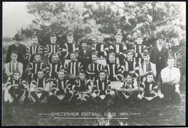
Photographs, x 3 Black & White Cheltenham Football Club 1909,1913, 1946, 20thC
... committee made an application to the board of land works for land... committee made an application to the board of land works for land ...Known as the Rosellas, the early Cheltenham Football Club sides began playing on a regular basis in 1890, and would travel long distances by steam train to play country teams, such as Ballarat where they would arrive at their destination, play the match, socialize then return to the station. Opposition players and supporters would give three hearty cheers on their departure. The Cheltenham home games were played on a paddock on the corner of Park and Charman roads in Cheltenham. In 1907 the Cheltenham progress committee made an application to the board of land works for land in Weatherall Road for recreational service to the public. That application was received and granted, then developed where Cheltenham Recreational Reserve now stands. The land in the early days was virgin bush and the response for voluntary help to clear the area was outstanding. Nearly all the market gardeners in the district along with horses, ploughs, axes, shovels completely cleared the area in three weeks. The Moorabbin council then leveled the playing area and erected a post and rail fence around the ground. Pine tree shrubs were then planted on the west side of the ground. The ground was opened in 1909 and the first Cheltenham side entered in the newly formed Federal Football Association along with seven other foundation members, Mordialloc, Mentone, Moorabbin, Frankston, Glenhuntly, Elsternwick, and Ellindale. The grand final for that year, 1909 was a hard encounter between Cheltenham and Ellindale with Cheltenham coming out victors, thus becoming the inaugural Federal Football Association premiers. Cheltenham went onto win five senior premierships in the Federal Football Association by the end of the 1920s, they won the flags in 1909, 1911, 1913, 1922 and 1925, with the late Percy Woff playing in all 5 premiership sides and was captain in 1922. 1928 saw the start of an outstanding career from our oldest living player Tom Connor. Cheltenham continued to win premierships in the 1920’s and 1930’s with juniors taking out the 1929 and 1933 flags, under the guidance of Woff, and that continued in 1934 when Cheltenham took out the 1st XVIII and 2nd XVIII premierships. Cheltenham produced its only Brownlow medallist in Peter Box who played in the late 1940s, before going to Footscray where he became a champion. The 3rd XVIII went through the season undefeated in 1974 winning the premiership, with Trevor Barker a key player before going to St Kilda the following year. The club won three senior premierships under coach Barry White in 1992, 1993 and 1995. ( from CFNC website 2019) Cheltenham Football Club was formed 1890 and succeeded in winning many Premierships as a member of the Federal Football Association, Outstanding players Peter Box Brownlow Medalist 1956 Footscay VFL, , Trevor Barker and Kevin Roberts St Kilda VFL.3x Black & White photographs of the players in the Australian Rules Cheltenham Football Club 1909, 1913 and 1946 extra photo of Peter Box Folio 10 MAV 01059a) CHELTENHAM FOOTBALL CLUB 1909 Cheltenham Football Club 1909. Back row: A Chandler, committee member; R. Robertson, back-pocket; J. Harris, half back flank; J Adams, ruck and forward-pocked; M. J. Monk, club president; L. Woff, back-pocket; W. Adams, ruck and back-pocket; P. Woff, rover and forward-pocket; A Monk, committee member. Middle row: W. Hore, back pocket and ruck; A. Towns, half-forward flank; W. Carson, full back; F. Andrews, captain-half forward flank; H. Butler, centre half back; J. Warburton, centre half-forward; A. Slater, half-back flank; F. Fisher, half-forward flank; C. Sherwood, trainer. Front Row: G Gouldthorpe, wing; H. King, full-forward; W. Johnston, ruck and forward-pocket; P Spears, rover and forward-pocket; F. Bichl, wing; A. Bichl. rover and forward-pocket; F. Butler, centre player. Courtesy, Lionel Seal. ( from CFC website 2019) b) CHELTENHAM 1913 PREMIERS c) CHELTENHAM -1946 / Back row - J. Fisher, G.Corrigan, N.Hocking, F.Virtue, R.Craven, L.Baker, M.Blundell / 2nd Row - J.Phillips, T.Connor, E.Hawkins, A.Blakely, G.Baker, A.Dark, J.Barker, D.Craven, J.Pickering, P.Cameron,/ W.Hicks, G.Hoskings, R.Beihl, A.Hubbard, R.Kier, C.Russell. / Front Row - Clark Taylor, J.Slade, N.Niel, J.Brooks, T,Butler, H.Hosking, C.Hacusler, E.Hornibrook, W.Briggs, B.Russell, L.Biehl, / W Ripponcheltenham football club, australian rules football, victorian football association, victorian football league, smith j l; smith mary ann, stanley helen, , chaff cutter, horse drawn carts, toll gates brighton, motor cars 1900, steam engines, early settlers, bentleigh, parish of moorabbin, city of moorabbin, county of bourke, moorabbin roads board, shire of moorabbin, henry dendy's special survey 1841, were j.b.; bent thomas, o'shannassy john, king richard, charman stephen, highett william, ormond francis, maynard dennis, market gardeners, vineyards, orchards, cheltenham, two acre village, holloway josiah,, woff percy, connor tom, box peter, barker trevor, white barry, browlow charles, -
Port Melbourne Historical & Preservation Society
Plan - Land sub-division at 34 Crockford Street, MMBW, Melbourne and Metropolitan Board of Works, Apr 1958
MMBW plan to sub-divide land at 34 Crockford St.built environment - commercial, percival edward mann, sue pentland, mmbw, melbourne and metropolitan board of works -
Port Melbourne Historical & Preservation Society
Legal Record, Act to authorise The Melbourne and Hobsons Bay Railway Company to sell their undertaking and property and to vest the same in the Board of Land and Works for other purposes, 20 Jan 1853
... same in the Board of Land and Works for other purposes... and to vest the same in the Board of Land and Works for other purposes... and to vest the same in the Board of Land and Works for other purposes ...Victorian Parliamentary Act "to authorise The Melbourne and Hobsons Bay Railway Company to sell their undertaking and property and to vest the same in the Board of Land and Works for other purposes" 14 November 1878: 13pp photocopy of Acttransport - railways, parks and gardens, melbourne & hobsons bay railway company, melbourne & hobsons bay united railway company -
 Melbourne Water
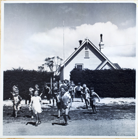
Photograph, North Cocoroc State Primary School, 1950s
... melbourne metropolitan board of works... of the Melbourne Metropolitan Board of Works (MMBW), now known as Melbourne... of the Melbourne Metropolitan Board of Works (MMBW), now known as Melbourne ...As the Yarra became unsuitable as a source of water, several attempts were made to find alternative sources for the growing population of Melbourne. It was not until 1891 that the efforts to sewer Melbourne came to fruition with the setting up of the Melbourne Metropolitan Board of Works (MMBW), now known as Melbourne Water. From 1891 until 1992, it was the responsibility of the MMBW to safeguard public health by providing a sewerage system and a safe water supply system. In 1992, The MMBW merged with a number of smaller urban water authorities to form Melbourne Water. The township of Cocoroc was created in 1894 at the Metropolitan Sewage Farm (now the Western Treatment Plant) to house the workers it employed. The name 'Cocoroc' means 'frog' in the language of the Wathaurung people — the Traditional Owners of the land the treatment plant was built on. By the early 1950s there were nearly 100 houses, a town hall, football ground (and team), swimming pool, tennis courts, four schools and a post office, and by the 1970s some 500 people were living in Cocoroc. As it became too expensive for the MMBW to subsidise, Cocoroc was abandoned. By 1973 most of the houses and other buildings were demolished or moved to Werribee. All that is left now of Cocoroc are two small, empty, concrete swimming pools, a few weatherboard sheds and a big iron water tank. This photograph detailing an exterior view of the North Cocoroc State Primary School, is historically significant as it captures children at play within a purpose built community. The School that was one of four was built to educate the children of the MMBW workers. As the school no longer exists, this photograph is the only tangible evidence left of the building, also showcasing the style of buildings in this era. cocoroc, township, school, mmbw, melbourne metropolitan board of works, melbourne water -
 Melbourne Water
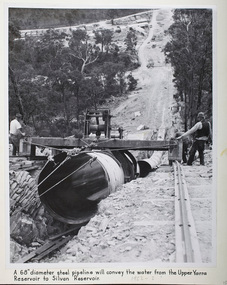
Photograph - Steel Pipeline, 1952
... melbourne metropolitan board of works... melbourne metropolitan board of works melbourne water Upper Yarra ...The Upper Yarra Reservoir supplies the Silvan Reservoir, which distributes water throughout the Melbourne metropolitan area. The dam was completed in 1957 and is a rolled earthfill and rockfill embankment. This photograph shows a 68" diameter steel pipeline that was to convey the water from the Upper Yarra Reservoir to the Silvan Reservoir.This photograph is significant as it provides a detailed insight into the Boards activity and construction of one of Melbourne's most important water supply systems. Furthermore, it is of historical importance to the history of Melbourne while it is representative of shaping Melbourne's environments, transforming and managing land and natural resources, and providing urban infrastructure and services. The photograph itself is aesthetically pleasing, through its depth of field and use of shape with an interesting composition. Black and white photographmmbw, melbourne metropolitan board of works, melbourne water, upper yarra reservoir, silvan reservoir, water, waterway, dam -
 Melbourne Water
Photograph - Tunnel at the O'Shannasy Dam, 9th April 1921
... melbourne metropolitan board of works... with clothing. mmbw melbourne metropolitan board of works melbourne ...The O'Shannassy Reservoir supplies water to the Silvan Reservoir, which distributes it to most parts of Melbourne. The dam was completed in 1928 and is an earthfill embankment with a reinforced concrete core wall.This photograph is significant as it provides a detailed insight into the Boards activity and construction of one of Melbourne's most important water supply systems. Furthermore, it is of historical importance to the history of Melbourne while it is representative of shaping Melbourne's environments, transforming and managing land and natural resources, and providing urban infrastructure and services. This photograph also covers the theme of Safety, depicting the safety standards of the time particularly with clothing. Black and white photographmmbw, melbourne metropolitan board of works, melbourne water, silvan reservoir, o'shannassy reservoir, construction, work, men, infrastructure -
 Puffing Billy Railway
Double Headed Rail, circa 1872 - 1883
... Department of Railways, part of the Board of Land and Works... Department of Railways, part of the Board of Land and Works ...Double Headed Rail from Ravenswood Station Siding which was dismantled circa 1987 the two rails were stored for a time at Maldon before being donated to Puffing Billy Museum Bearing makers marks of Wilson & Cammell - Dronfield- Steel works Wilson & Cammell made Steel rails at their Dronfield Steel Works, in Dronfield, North East Derbyshire, England from 1872 - 1883 Double-headed rail In late 1830s Britain, railway lines had a vast range of different patterns. One of the earliest lines to use double-headed rail was the London and Birmingham Railway, which had offered a prize for the best design. This rail was supported by chairs and the head and foot of the rail had the same profile. The supposed advantage was that, when the head became worn, the rail could be turned over and re-used. In practice, this form of recycling was not very successful as the chair caused dents in the lower surface, and double-headed rail evolved into bullhead rail in which the head was more substantial than the foot. Info from Wikipedia - Rail Profile https://en.wikipedia.org/wiki/Rail_profile The first records of double headed rail being used In Victoria by Victorian Railways was in 1859, the rails, chairs, oak and trenails were imported from UK. After the 1870’s the Victorian Railways went over to using flat bottom rails, but they still needed replacement double headed rail for lines already laid and this continued up to at least 1883 Wilson & Cammell - Dronfield- Steel works Wilson & Cammell made Steel rails at their Dronfield Steel Works, in Dronfield England from 1872 - 1883 Mount Alexander & Murray River Railway The Melbourne, Mount Alexander & Murray River Railway Company received parliamentary assent in February 1853 to build Victoria's first inland railway from Melbourne to Williamstown, and Melbourne to Bendigo and Echuca. Construction commenced in January 1854 with work on a pier at Williamstown but lack of funds slowed progress, eventually prompting the company to sell out to the government. The 100-mile (162 km) section to Bendigo opened in October 1862. Its cost of £35,000 per mile made it the most expensive railway ever built in Australia. In 1864, the line was extended to Echuca, tapping into the booming Murray-Darling paddlesteamer trade. info from Museums Victoria - Victorian Railways https://museumsvictoria.com.au/railways/theme.aspx?lvl=3&IRN=450&gall=456 1863 Ravenswood Station open on the 1st Feb 1863 Victorian Railways - purchased and imported the Rail and Chairs from Raleigh, Dalgleish, White and Co. London Importation of railway plant : abstract of a return to an order of the Legislative Assembly dated 27th June 1860 for - Copies of the advertisements calling for tenders, the names of the tenderers and the accounts and correspondence with Mr Brunel relating thereto GP V 1859/60 no. C 15 http://www.parliament.vic.gov.au/papers/govpub/VPARL1859-60NoC15.pdf Report from the Select Committee upon the Importation of Railway Plant : together with proceedings of the Committee, minutes of evidence and appendix GP V 1859/60 no. D 38 (2.9 MB) http://www.parliament.vic.gov.au/papers/govpub/VPARL1859-60NoD38.pdf Ravenswood Siding When the Victorian Railways were established in 1856 they adopted one of the popular British permanent way standards - heavy 80lb (36.3kg) double-headed rail held up right in cast iron chairs attached to transverse timber sleepers by wooden pegs called trenails. The Ravenswood Railway siding was constructed in 1862 with 12 feet wrought iron double-head rail held in cast iron chairs with Ransom and May patent compressed keys. Trenails held the chairs to the sleepers and the joints were secured in joint chairs. Joints were subsequently joined using fish plates. It formed part of the Melbourne to Echuca rail line, initially known as the Melbourne, Mt Alexander and Murray River Railway. George Christian Derbyshire, the first Engineer-in-Chair of the Victorian Railways was responsible for the design and construction of the works. No new lines were built in Victoria using double-headed rail after 1870. The siding was disconnected from the main line in 1988. The Ravenswood Railway Siding demonstrates the original 1856 philosophy of the Victorian Railways to adopt British permanent way technology. The siding demonstrates significant aspects in the development of permanent way technology in England and Victoria over the period from the 1830's to the 1880's. The chairs in the Ravenswood siding are physical evidence of early railway technology rendered obsolete 120 years ago, namely joint chairs at rail joints and trenails to secure the chairs to the sleepers. The double-headed rail demonstrates an important stage in the evolution of British rail technology in the 1830s. The old fish plates, square headed bolts and square nuts demonstrate the success of fishing the rail joins. The Ravenswood siding demonstrates the earliest form of rail joint technology developed in England, and existing in Australia, the joint chair. In part of the siding the sequence of joint and intermediate chairs is consistent with the 1856 specifications, that sequence is rare with the joints secured in joint chairs. The survival of chairs in this sequence is rare and almost certainly demonstrates that they remained in continuous use at the same location from 1862 to 1988. This remnant of the Ravenswood siding has survived 126 years. The siding has proved to be the most significant of extant remnant double-headed sidings in Victoria, containing a rare combination of early permanent way technologies. Construction dates 1862, Info from Ravenswood Railway Siding Victorian Heritage Database Report http://vhd.heritagecouncil.vic.gov.au/places/4693/download-report The remaining section of this siding is significant at the State and National levels in that it demonstrates the use of chaired rail by the Victorian Railways Department for the Trunk Lines and, more particularly, the following stages in the evolution of this long obsolete method of permanent way construction: a) The use of joint chairs and intermediate chairs at regular intervals inferring that the original wrought iron rail lengths were 12 feet, as is known through documentary sources to have been the case. The survival of chairs in this sequence is unique and almost certainly demonstrates that they have remained in continuous use at the same location and in the same sequence from 1862 to 1988 . b) The use of joint chairs and intermediate chairs designed for use with trenails. c) The use of later intermediate chairs designed for use with steel pins and the use of fished joints with steel double head chaired rail, representing a second method of constructing the permanent way using chaired rail technology. info from Ravenswood Siding - Melbourne/Echuca Railway Line - Victorian Heritage Database Report http://vhd.heritagecouncil.vic.gov.au/places/70103/download-report Addition to Citation for Melbourne to EchucaRailway Line 1/10/1990 Double Head Rail The surviving lengths of double head rail with chairs on this railway compare with one surviving similar remnant on the Geelong to Ballarat railway and are representative of permanent way construction techniques applied exclusively to the two trunk railways of the 1860's. In this respect they are rare survivors and may be unique at the national level and of technical importance at the international level to the extent that they enhance contemporary understanding of early railway building technology. Surviving lengths of chaired double head rail survive at Kyneton, Ravenswood and Bendigo on this railway and include a number of different types of cast iron intermediate and joint chairs with hardwood keys and metal pins. The Ravenswood siding is of special significance for the diversity of chair types and for the sequence of chairs recalling rail lengths known to be associated with construction of the line in 1862. Construction of the Railway Tenders closed on 24 March 1858 with no less than 133 tenders being received. A contract was let to Cornish and Bruce for £3,356,937 to commence work on 1 June 1858 and complete the line by 31 July 1861. Cornish and Bruce made quick early progress with the Melbourne to Sunbury section being officially opened on 13 January 1859. The line was officially opened to Bendigo (Sandhurst) on 20 October 1862 by the Governor of Victoria, Sir Henry Barkly. A great banquet was held for 800 guests and this was followed by a grand ball. The extension of the line to Echuca was a relatively simple matter as that part of the line was across plain country without any significant engineering challenges. Tenders were called for the work in 1863 and the work was completed in 1864 by contractors Collier and Barry Apart from the line contractors, other firms directly involved were J Shire law and Co (sleepers), R Fulton, Langlands Brothers and Co, William Crossley (water supply), B Moreland, Langlands Brothers and Co (platelayers lorries), E Chambers (iron pins, traversers), Miller and McQuinstan (luggage vans and steam engines) and various contractors for building works. Info from Engineers Australia Engineering Heritage Victoria Nomination for Recognition under the Engineering Heritage Australia Heritage Recognition Program for the Goldfields Railways - Melbourne , Bendigo & Echuca Railway Page 25 - .2.9.2 Statement from National Trust of Australia (Victoria) Listing number B5323 for Mt Alexander/Murray Valley Rail Line: Page 69 - Theme 3 https://www.engineersaustralia.org.au/portal/system/files/engineering-heritage-australia/nomination-title/Melbourne_%20Bendigo_Echuca%20Railway%20Nomination.pdf The Melbourne, Mount Alexander and Murray River Railway Company was a railway company in Victoria, Australia. It was established on 8 February 1853 to build a railway from Melbourne to Echuca on the Victorian-NSW border and a branch railway to Williamstown. The company struggled to make any progress and on 23 May 1856, the colonial Government took over the Company and it became part of the newly established Department of Railways, part of the Board of Land and Works. The Department of Railways became Victorian Railways in 1859. Construction of the Bendigo line commenced in 1858, but this private consortium also met with financial difficulties when it was unable to raise sufficient funds, and was bought out by the Victorian colonial government. The design work was then taken over by Captain Andrew Clarke, R. E., Surveyor-General of Victoria, with bridge designs completed by Bryson and O'Hara The contract for the first stage of the line from Footscray to Sandhurst (now Bendigo), was let to Cornish and Bruce for £3,356,937.2s.2d ($6.714 million) with work commencing on 1 June 1858. Completion of the permanent way was to be by 31 July 1861 https://en.wikipedia.org/wiki/Melbourne,_Mount_Alexander_and_Murray_River_Railway_Company Victorian Railways - purchased and imported the Rail and Chairs from Raleigh, Dalgleish, White and Co. London Importation of railway plant : abstract of a return to an order of the Legislative Assembly dated 27th June 1860 for - Copies of the advertisements calling for tenders, the names of the tenderers and the accounts and correspondence with Mr Brunel relating thereto GP V 1859/60 no. C 15 http://www.parliament.vic.gov.au/papers/govpub/VPARL1859-60NoC15.pdf Report from the Select Committee upon the Importation of Railway Plant : together with proceedings of the Committee, minutes of evidence and appendix GP V 1859/60 no. D 38 (2.9 MB) http://www.parliament.vic.gov.au/papers/govpub/VPARL1859-60NoD38.pdf Victorian Railways : report of the Board of Land and Works November 1862 GP V 1862/63 no. 21 (2.8 MB) https://www.parliament.vic.gov.au/papers/govpub/VPARL1862-63No21.pdfHistoric - Victorian Railways - Double Headed rail Ravenswood Railway Station and Siding Victorian Heritage Database Reports Victorian Heritage Register VHR H1100 Victorian Heritage Register VHR H1786 National Trust VHR H1100 Mount Alexander and Murray River Rail way Line National Trust2 rail lengths of Double Headed Rail made of Iron makers marks : Wilson & Cammell - Dronfield - Steel and 20 joint chairs with metal rail pins Makers mark Wilson & Cammell - Dronfield - Steel (possible date 187? very hard to read ) puffing billy, double headed rail, wilson & cammell - dronfield - steel works, ravenswood station siding, melbourne to echuca rail line, initially known as the melbourne, mt alexander and murray river railway. -
 Victorian Aboriginal Corporation for Languages
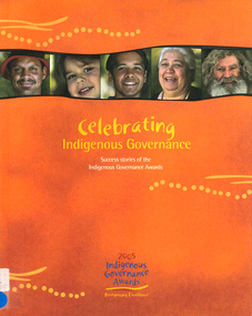
Book, Rowena Withers, Celebrating Indigenous governance : success stories of the Indigenous governance awards, 2005
Good governance means good business What is governance? The Indigenous Governance Awards Key elements of good governance Finalists 2005: Koorie Heritage Trust, Victoria; Central Australian Aboriginal Congress, NT; Sunrise Health Service, NT; Goldfields Land and Sea Council, WA; Institute for Aboriginal Development, NT; Maari Ma Health Aboriginal Corporation NSW; North Coast Aboriginal Corporation for Community Health Qld; Tiwi Islands Local Government, NT What works: lessons from the 2005 Indigenous Governance awards Governing body: choosing the board; Size and frequency of meetings; Board change and continuity; Processes of decision-making; Making good decisions; Financial decision-making; Accountability tools Managing and implementing decisions: carrying out recommendations; Informing stakeholders Conflict resolution: conflicts among the board; Complaints from members; Staff conflicts Leadership development: developing youth; Staff development and training Cultural norms and values: Boards and elders; Community and culture Future planning.colour photographsbusiness enterprise, indigenous business -
 Chiltern Athenaeum Trust
Painting - Oil painting on gumleaf by Alfred William Eustace, circa 1851 to 1907
This gum leaf painting is one of a pair displayed on foil in the same frame. It is typical of many paintings by the self-taught Australian artist Alfred William Eustace (1820-1907). A.W. Eustace, a well-known Australian artist, was born in Berkshire, England, where he was an assistant gamekeeper to the Earl of Craven at Ashdown Park. He migrated to Australia with his wife and children in 1851 and camped on the Ullina and Eldorado Runs on the Black Dog Creek at Chiltern, which was in excess of 50,000 acres of grazing land. A.W. Eustace was employed as a shepherd by Jason Withers and while tending his flocks in the solitude of the bush, Eustace turned his attention to painting and music to while away the long and weary hours. He endeavoured to capture the spirit of the bush painting on board, canvas or tin plate, but as these materials were not always readily available he then started painting on large round eucalyptus leaves from the White and Red Box trees that grew around about him. About 1856 he painted a small picture of the famous Woolshed goldrush and during the next few years became well known in North-East Victoria. John Sadlier, a police officer stationed at Beechworth said that Eustace painted 'some really exquisite scenes. He was of an easy-going dreamy temperament, a student of nature only, despising the works of men. Unfortunately his drawings were on eucalyptus leaves, the largest and roundest he could find and not on canvas, and no doubt have all perished long ago.' In 1876 the Melbourne Age newspaper reported, 'Eustace’s celebrated paintings on gum leaves are again attracting attention,…Mr Eustace is an elegant artist…he seems without effort to catch the colour and spirit of Australian scenery…' In 1864 A.W. Eustace held an Art Union in Albury, and again in 1884 in Ballarat. He exhibited at the Victorian Academy of Arts in 1877 and also held an exhibition of gum leaf paintings at Stevens Gallery, Melbourne in 1893. By 1896 he was receiving orders from heads of states in Europe, with his works acknowledged by Queen Victoria, Emperor Frederick of Germany and the Czar of Russia, as well as the Governors of New South Wales and Victoria. His paintings reflected his ability to paint the sky in his realistic style which is still noted by art critics of the day. A.W. Eustace was also a skillful taxidermist. The collection of birds and animals that can be seen at the Beechworth Museum are examples of his taxidermy skill. When not doing his work, painting or taxidermy, he regularly contributed letters and verse to the Chiltern newspaper, The Federal Standard. A book of verse in his hand writing was presented to The Athenaeum Trust by the Boadle family. In the 1870’s he became interested in spiritualism often being involved in lively debate at lectures and séances. Alfred William Eustace died in 1907 and is buried in the Chiltern New Cemetery with his wife Sarah and one of his daughters, Elizabeth.An oil painting on gum leaf by the well-known Australian artist Alfred William Eustace. He was a self-taught artist during the 19th and early 20th century and a prominent resident of Chiltern. Oil painting on gum leaf by Alfred William Eustace. A scene of a log cabin on Black Dog Creek Road, Chiltern, with Skeleton Hill in the background. The canvas is a juvenile Red Box (Eucalyptus polyanthemos) leaf. It is one of a pair of Eustace gum leaf paintings mounted on gold foil, under glass in a brown frame. Inscription on back. Labels on back: Rehoused by The Centre for Cultural Materials/ Conservation, University of Melbourne "Oil on Gum Leaf"/ by Alfred William Eustace/ Donor:- Cam & Connie Boadle/ Wales U.K. Crescent/ MUSEUM/ GRADE/ 24 OCT 1998/ CONSERVATION BOARD ALBURY/ PICTURE FRAMERS/ Shop 15 & 16/ AMP Lane,/ Albury, 2640/ Ph: 02 6021 7088black dog creek, chiltern, alfred eustace, skeleton hill, gum leaf, painting, eustace -
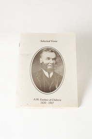 Chiltern Athenaeum Trust
Booklet - Booklet of Selected Verse by A.W. Eustace published 1992, Selected Verse/ A.W. Eustace of Chiltern/1820-1907
Alfred William Eustace was a well-known self-taught Australian artist who spent his spare time painting the local landscapes in the Chiltern area. When not doing his work or painting, Eustace regularly contributed letters and verse to the Chiltern newspaper "The Federal Standard". A collection of A. W Eustace's verse and other writings, written between 1845 and 1899, was presented to The Chiltern Athenaeum Trust by Cam Boadle, a grandson of A.W. Eustace, and his wife Connie. The Chiltern Athenaeum Trust created a booklet of some of his poetry which was published in 1992. Copyright for the booklet is held by Chiltern Athenaeum Museum 1992. In the 1870’s he became interested in spiritualism often being involved in lively debate at lectures and séances. A.W.Eustace was born in Berkshire, England, where he was an assistant gamekeeper to the Earl of Craven at Ashdown Park. He migrated to Australia with his wife and children in 1851 and worked on the Ullina and Eldorado Runs on the Black Dog Creek at Chiltern, which was in excess of 50,000 acres of grazing land. A.W. Eustace was employed as a shepherd by Jason Withers and while tending his flocks in the solitude of the bush, Eustace turned his attention to painting and music to while away the long and weary hours. He endeavoured to capture the spirit of the bush painting on board, canvas or tin plate, but as these materials were not always readily available he then started painting on large round eucalyptus leaves from the White and Red Box trees that grew around about him. About 1856 he painted a small picture of the famous Woolshed goldrush and during the next few years became well known in North-East Victoria. John Sadlier, a police officer stationed at Beechworth said that Eustace painted 'some really exquisite scenes. He was of an easy-going dreamy temperament, a student of nature only, despising the works of men. Unfortunately his drawings were on eucalyptus leaves, the largest and roundest he could find and not on canvas, and no doubt have all perished long ago.' In 1876 the Melbourne Age newspaper reported, 'Eustace’s celebrated paintings on gum leaves are again attracting attention,…Mr Eustace is an elegant artist…he seems without effort to catch the colour and spirit of Australian scenery…' In 1864 A.W. Eustace held an Art Union in Albury, and again in 1884 in Ballarat. He exhibited at the Victorian Academy of Arts in 1877 and also held an exhibition of gum leaf paintings at Stevens Gallery, Melbourne in 1893. By 1896 he was receiving orders from heads of states in Europe, with his works acknowledged by Queen Victoria, Emperor Frederich of Germany and the Czar of Russia, as well as the Governors of New South Wales and Victoria. His paintings reflected his ability to paint the sky in his realistic style which is still noted by art critics of the day. A.W. Eustace was also a skilful taxidermist. The collection of birds and animals that can be seen at the Beechworth Museum are examples of his taxidermy skill. Alfred William Eustace died in 1907 and is buried in the Chiltern New Cemetery with his wife Sarah and one of his daughters, Elizabeth. Alfred William Eustace made a valuable contribution to the culture of 19th century Chiltern and his booklet of Selected Verse gives us an insight into life during that time.22 page booklet of Selected Verse/ A.W. Eustace of Chiltern/ 1820-1907. Printed on thick cream paper with a copy of an oval photograph of the author.a. w. eustace, selected verse, chiltern -
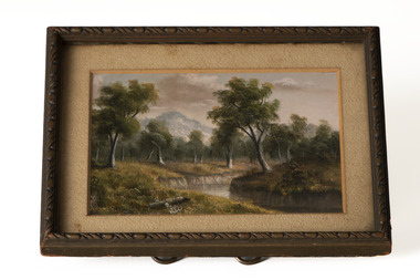 Chiltern Athenaeum Trust
Painting - Oil Painting, Alfred Eustace
This is one of a set of 3 miniature oil paintings by the self-taught artist Alfred William Eustace (1820-1907). A.W. Eustace, an Australian artist, was born in Berkshire, England, where he was an assistant gamekeeper to the Earl of Craven at Ashdown Park. He migrated to Australia with his wife and children in 1851 and worked on the Ullina and Eldorado Runs on the Black Dog Creek at Chiltern, which was in excess of 50,000 acres of grazing land. A.W. Eustace was employed as a shepherd by Jason Withers and while tending his flocks in the solitude of the bush, Eustace turned his attention to painting and music to while away the long and weary hours. He endeavoured to capture the spirit of the bush and painted on board, canvas or tin plate, but as these materials were not always readily available he then started painting on large round eucalyptus leaves from the White and Red Box trees that grew around about him. He became known as the "Bush Artist." About 1856 he painted a small picture of the famous Woolshed goldrush and during the next few years became well known in North-East Victoria. John Sadlier, a police officer stationed at Beechworth said that Eustace painted 'some really exquisite scenes. He was of an easy-going dreamy temperament, a student of nature only, despising the works of men. Unfortunately his drawings were on eucalyptus leaves, the largest and roundest he could find and not on canvas, and no doubt have all perished long ago.' In 1876 the Melbourne Age newspaper reported, 'Eustace’s celebrated paintings on gum leaves are again attracting attention,…Mr Eustace is an elegant artist…he seems without effort to catch the colour and spirit of Australian scenery…' In 1864 A.W. Eustace held an Art Union in Albury, and again in 1884 in Ballarat. He exhibited at the Victorian Academy of Arts in 1877 and also held an exhibition of gum leaf paintings at Stevens Gallery, Melbourne in 1893. By 1896 he was receiving orders from heads of states in Europe, with his works acknowledged by Queen Victoria, Emperor Frederick of Germany and the Czar of Russia, as well as the Governors of New South Wales and Victoria. His paintings reflected his ability to paint the sky in his realistic style which is still noted by art critics of the day. A.W. Eustace was also a skilful taxidermist. The collection of birds and animals that can be seen at the Beechworth Museum are examples of his taxidermy skill. When not doing his work, painting or taxidermy, he regularly contributed letters and verse to the Chiltern newspaper, The Federal Standard. A book of verse in his hand writing was presented to The Athenaeum Trust by the Boadle family. In the 1870’s he became interested in spiritualism often being involved in lively debate at lectures and séances. Alfred William Eustace died in 1907 and is buried in the Chiltern New Cemetery with his wife Sarah and one of his daughters, Elizabeth. Miniature oil painting of a landscape, with creek in foreground and bush and hill behind, by A.W. Eustace, under glass, in original timber frame with beige matte and a twist wire stand. One of 3 miniatures. No signature visiblealfred eustace, chiltern, oil painting, landscape -
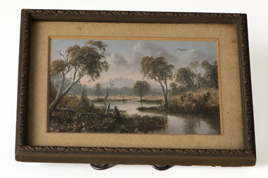 Chiltern Athenaeum Trust
Painting - Oil painting, Alfred Eustace
This is one of a set of 3 miniature oil paintings by the self-taught artist Alfred William Eustace (1820-1907). A.W. Eustace, an Australian artist and taxidermist, was born in Berkshire, England, where he was an assistant gamekeeper to the Earl of Craven at Ashdown Park. He migrated to Australia with his wife and children in 1851 and worked on the Ullina and Eldorado Runs on the Black Dog Creek at Chiltern, which was in excess of 50,000 acres of grazing land. A.W. Eustace was employed as a shepherd by Jason Withers and while tending his flocks in the solitude of the bush, Eustace turned his attention to painting and music to while away the long and weary hours. He endeavoured to capture the spirit of the bush painting on board, canvas or tin plate, but as these materials were not always readily available he then started painting on large round eucalyptus leaves from the White and Red Box trees that grew around about him. About 1856 he painted a small picture of the famous Woolshed goldrush and during the next few years became well known in North-East Victoria. John Sadlier, a police officer stationed at Beechworth said that Eustace painted 'some really exquisite scenes. He was of an easy-going dreamy temperament, a student of nature only, despising the works of men. Unfortunately his drawings were on eucalyptus leaves, the largest and roundest he could find and not on canvas, and no doubt have all perished long ago.' In 1876 the Melbourne Age newspaper reported, 'Eustace’s celebrated paintings on gum leaves are again attracting attention,…Mr Eustace is an elegant artist…he seems without effort to catch the colour and spirit of Australian scenery…' In 1864 A.W. Eustace held an Art Union in Albury, and again in 1884 in Ballarat. He exhibited at the Victorian Academy of Arts in 1877 and also held an exhibition of gum leaf paintings at Stevens Gallery, Melbourne in 1893. By 1896 he was receiving orders from heads of states in Europe, with his works acknowledged by Queen Victoria, Emperor Frederick of Germany and the Czar of Russia, as well as the Governors of New South Wales and Victoria. His paintings reflected his ability to paint the sky in his realistic style which is still noted by art critics of the day. A.W. Eustace was also a skilful taxidermist. The collection of birds and animals that can be seen at the Beechworth Museum are examples of his taxidermy skill. When not doing his work, painting or taxidermy, he regularly contributed letters and verse to the Chiltern newspaper, The Federal Standard. A book of verse in his hand writing was presented to The Athenaeum Trust by the Boadle family. In the 1870’s he became interested in spiritualism often being involved in lively debate at lectures and séances. Alfred William Eustace died in 1907 and is buried in the Chiltern New Cemetery with his wife Sarah and one of his daughters, Elizabeth.Miniature oil painting of a landscape, with creek and grassland in foreground surrounded by bushland and hill in distance, by A.W. Eustace, under glass in original timber frame with beige matte and a twist wire stand. One of 3 miniatures. No signature visiblealfred eustace, oil painting, landscape, chiltern -
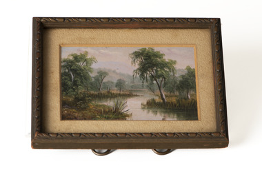 Chiltern Athenaeum Trust
Painting - Oil Painting, Alfred Eustace
This is one of a set of 3 miniature oil paintings by the self-taught artist Alfred William Eustace (1820-1907). A.W. Eustace, an Australian artist, was born in Berkshire, England, where he was an assistant gamekeeper to the Earl of Craven at Ashdown Park. He migrated to Australia with his wife and children in 1851 and worked on the Ullina and Eldorado Runs on the Black Dog Creek at Chiltern, which was in excess of 50,000 acres of grazing land. A.W. Eustace was employed as a shepherd by Jason Withers and while tending his flocks in the solitude of the bush, Eustace turned his attention to painting and music to while away the long and weary hours. He endeavoured to capture the spirit of the bush painting on board, canvas or tin plate, but as these materials were not always readily available he then started painting on large round eucalyptus leaves from the White and Red Box trees that grew around about him. About 1856 he painted a small picture of the famous Woolshed goldrush and during the next few years became well known in North-East Victoria. John Sadlier, a police officer stationed at Beechworth said that Eustace painted 'some really exquisite scenes. He was of an easy-going dreamy temperament, a student of nature only, despising the works of men. Unfortunately his drawings were on eucalyptus leaves, the largest and roundest he could find and not on canvas, and no doubt have all perished long ago.' In 1876 the Melbourne Age newspaper reported, 'Eustace’s celebrated paintings on gum leaves are again attracting attention,…Mr Eustace is an elegant artist…he seems without effort to catch the colour and spirit of Australian scenery…' In 1864 A.W. Eustace held an Art Union in Albury, and again in 1884 in Ballarat. He exhibited at the Victorian Academy of Arts in 1877 and also held an exhibition of gum leaf paintings at Stevens Gallery, Melbourne in 1893. By 1896 he was receiving orders from heads of states in Europe, with his works acknowledged by Queen Victoria, Emperor Frederick of Germany and the Czar of Russia, as well as the Governors of New South Wales and Victoria. His paintings reflected his ability to paint the sky in his realistic style which is still noted by art critics of the day. A.W. Eustace was also a skilful taxidermist. The collection of birds and animals that can be seen at the Beechworth Museum are examples of his taxidermy skill. When not doing his work, painting or taxidermy, he regularly contributed letters and verse to the Chiltern newspaper, The Federal Standard. A book of verse in his hand writing was presented to The Athenaeum Trust by the Boadle family. In the 1870’s he became interested in spiritualism often being involved in lively debate at lectures and séances. Alfred William Eustace died in 1907 and is buried in the Chiltern New Cemetery with his wife Sarah and one of his daughters, Elizabeth.Miniature oil painting of a landscape with creek and surrounding trees by A.W. Eustace, under glass, in original dark brown timber frame with beige matte and a twist wire stand. One of 3 miniatures. Sticker on back: 188 (original Registration number)alfred eustace, chiltern, oil, landscape -
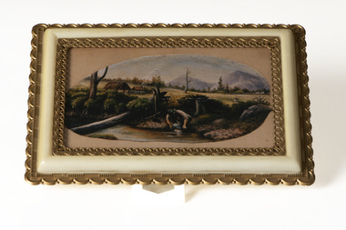 Chiltern Athenaeum Trust
Photograph - Gum Leaf, Alfred Eustace
This is a colour photograph of a gum leaf painting that is one of many done by the well-known self-taught Australian artist Alfred William Eustace (1820-1907). A.W. Eustace, an Australian artist, was born in Berkshire, England, where he was an assistant gamekeeper to the Earl of Craven at Ashdown Park. He migrated to Australia with his wife and children in 1851 and worked on the Ullina and Eldorado Runs on the Black Dog Creek at Chiltern, which was in excess of 50,000 acres of grazing land. A.W. Eustace was employed as a shepherd by Jason Withers and while tending his flocks in the solitude of the bush, Eustace turned his attention to painting and music to while away the long and weary hours. He endeavoured to capture the spirit of the bush painting on board, canvas or tin plate, but as these materials were not always readily available he then started painting on large round eucalyptus leaves from the White and Red Box trees that grew around about him. About 1856 he painted a small picture of the famous Woolshed goldrush and during the next few years became well known in North-East Victoria. John Sadlier, a police officer stationed at Beechworth said that Eustace painted 'some really exquisite scenes. He was of an easy-going dreamy temperament, a student of nature only, despising the works of men. Unfortunately his drawings were on eucalyptus leaves, the largest and roundest he could find and not on canvas, and no doubt have all perished long ago.' In 1876 the Melbourne Age newspaper reported, 'Eustace’s celebrated paintings on gum leaves are again attracting attention,…Mr Eustace is an elegant artist…he seems without effort to catch the colour and spirit of Australian scenery…' In 1864 A.W. Eustace held an Art Union in Albury, and again in 1884 in Ballarat. He exhibited at the Victorian Academy of Arts in 1877 and also held an exhibition of gum leaf paintings at Stevens Gallery, Melbourne in 1893. By 1896 he was receiving orders from heads of states in Europe, with his works acknowledged by Queen Victoria, Emperor Frederick of Germany and the Czar of Russia, as well as the Governors of New South Wales and Victoria. His paintings reflected his ability to paint the sky in his realistic style which is still noted by art critics of the day. A.W. Eustace was also a skilful taxidermist. The collection of birds and animals that can be seen at the Beechworth Museum are examples of his taxidermy skill. When not doing his work, painting or taxidermy, he regularly contributed letters and verse to the Chiltern newspaper, The Federal Standard. A book of verse in his hand writing was presented to The Athenaeum Trust by the Boadle family. In the 1870’s he became interested in spiritualism often being involved in lively debate at lectures and séances. Alfred William Eustace died in 1907 and is buried in the Chiltern New Cemetery with his wife Sarah and one of his daughters, Elizabeth.Colour photograph of an oil painting on gum leaf by A.W. Eustace. A man is panning for gold in a stream with a house and hills in the background. Under glass in a decorative gilt and cream coloured plastic frame.Hand writing on tape at back of frame: COPY OIL ON GUM LEAF 10" x 5" A W EUSTACE owned by Betty & Alf Brownlie 2260alfred eustace, gum leaf painting, chiltern, gold panning, gold -
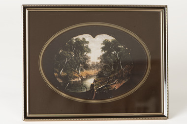 Chiltern Athenaeum Trust
Photograph - Gum Leaf, Alfred Eustace
This colour photograph of a gum leaf painting shows one of the many landscapes done by the well-known self-taught Australian artist Alfred William Eustace (1820-1907). A.W. Eustace, an Australian artist and taxidermist, was born in Berkshire, England, where he was an assistant gamekeeper to the Earl of Craven at Ashdown Park. He migrated to Australia with his wife and children in 1851 and worked on the Ullina and Eldorado Runs on the Black Dog Creek at Chiltern, which was in excess of 50,000 acres of grazing land. A.W. Eustace was employed as a shepherd by Jason Withers and while tending his flocks in the solitude of the bush, Eustace turned his attention to painting and music to while away the long and weary hours. He endeavoured to capture the spirit of the bush painting on board, canvas or tin plate, but as these materials were not always readily available he then started painting on large round eucalyptus leaves from the White and Red Box trees that grew around about him. About 1856 he painted a small picture of the famous Woolshed goldrush and during the next few years became well known in North-East Victoria. John Sadlier, a police officer stationed at Beechworth said that Eustace painted 'some really exquisite scenes. He was of an easy-going dreamy temperament, a student of nature only, despising the works of men. Unfortunately his drawings were on eucalyptus leaves, the largest and roundest he could find and not on canvas, and no doubt have all perished long ago.' In 1876 the Melbourne Age newspaper reported, 'Eustace’s celebrated paintings on gum leaves are again attracting attention,…Mr Eustace is an elegant artist…he seems without effort to catch the colour and spirit of Australian scenery…' In 1864 A.W. Eustace held an Art Union in Albury, and again in 1884 in Ballarat. He exhibited at the Victorian Academy of Arts in 1877 and also held an exhibition of gum leaf paintings at Stevens Gallery, Melbourne in 1893. By 1896 he was receiving orders from heads of states in Europe, with his works acknowledged by Queen Victoria, Emperor Frederick of Germany and the Czar of Russia, as well as the Governors of New South Wales and Victoria. His paintings reflected his ability to paint the sky in his realistic style which is still noted by art critics of the day. A.W. Eustace was also a skilful taxidermist. The collection of birds and animals that can be seen at the Beechworth Museum are examples of his taxidermy skill. When not doing his work, painting or taxidermy, he regularly contributed letters and verse to the Chiltern newspaper, The Federal Standard. A book of verse in his hand writing was presented to The Athenaeum Trust by the Boadle family. In the 1870’s he became interested in spiritualism often being involved in lively debate at lectures and séances. Alfred William Eustace died in 1907 and is buried in the Chiltern New Cemetery with his wife Sarah and one of his daughters, Elizabeth.Colour photograph of an oil painting on gum leaf by Alfred Eustace. Landscape featuring a deep creek surrounded by thick bushland displayed against dark brown backing paper which has a gilt oval surround to highlight the painting. Under glass, in a gold and dark brown metal frame.Sticker on back: 189. (the original registration number)alfred eustace, gum leaf painting, landscape -
 Chiltern Athenaeum Trust
Photograph
This black and white photograph of the grave of A.W. Eustace is believed to have been taken in September 1987 at the Chiltern New Cemetery. Alfred William Eustace, an Australian artist, was born in the small village of Ashbury, Berkshire, England, the son of John Eustace, Head Game-keeper to the Earl of Craven at the beautiful Ashdown Park. He migrated to Australia with his wife and children in 1851 and camped next to the Ullina and Eldorado Runs on the Black Dog Creek at Chiltern, which was owned by the Withers family and was in excess of 55,000 acres of grazing land. A.W. Eustace was employed as a shepherd by Jason Withers and while tending his flocks in the solitude of the bush, Eustace turned his attention to painting and music to while away the long and weary hours. He endeavoured to capture the spirit of the bush painting on board, canvas or tin plate, but as these materials were not always readily available he then started painting on large round eucalyptus leaves from the White and Red Box trees that grew around about him. About 1856 he painted a small picture of the famous Woolshed goldrush and during the next few years became well known in North-East Victoria. John Sadlier, a police officer stationed at Beechworth said that Eustace painted 'some really exquisite scenes. He was of an easy-going dreamy temperament, a student of nature only, despising the works of men. Unfortunately his drawings were on eucalyptus leaves, the largest and roundest he could find and not on canvas, and no doubt have all perished long ago.' In 1876 the Melbourne Age newspaper reported, 'Eustace’s celebrated paintings on gum leaves are again attracting attention,…Mr Eustace is an elegant artist…he seems without effort to catch the colour and spirit of Australian scenery…' In 1864 A.W. Eustace held an Art Union in Albury, and again in 1884 in Ballarat. He exhibited at the Victorian Academy of Arts in 1877 and also held an exhibition of gum leaf paintings at Stevens Gallery, Melbourne in 1893. By 1896 he was receiving orders from heads of states in Europe, with his works acknowledged by Queen Victoria, Emperor Frederick of Germany and the Czar of Russia, as well as the Governors of New South Wales and Victoria. His paintings reflected his ability to paint the sky in his realistic style which is still noted by art critics of the day. A.W. Eustace was also a skillful taxidermist. The collection of birds and animals that are in the Beechworth Museum collection are examples of his taxidermy skill. When not doing his work, painting or taxidermy, he regularly contributed letters and verse to the Chiltern newspaper, The Federal Standard. A book of verse in his hand writing was presented to The Athenaeum Trust by his relatives from the Boadle family. In the 1870’s he became interested in spiritualism often being involved in lively debate at lectures and séances. Alfred William Eustace died in 1907 and is buried in the Chiltern New Cemetery with his wife Sarah and one of his daughters, Elizabeth.A. W. Eustace, as well as being a well-known Australian artist, was a significant member of the Chiltern community.Black and white photograph of the grave of A.W. Eustace, under glass, in a metal frame.Sticker on back: 184 (original Registration number)a. w. eustace, grave, chiltern new cemetery -
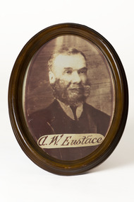 Chiltern Athenaeum Trust
Photograph
Alfred William Eustace (1820-1907), an Australian artist, was born in Berkshire, England, where he was an assistant gamekeeper to the Earl of Craven at Ashdown Park. He migrated to Australia with his wife and children in 1851 and camped beside the Ullina and Eldorado Runs on the Black Dog Creek at Chiltern, which was in excess of 50,000 acres of grazing land. A.W. Eustace was employed as a shepherd by Jason Withers and while tending his flocks in the solitude of the bush, Eustace turned his attention to painting and music to while away the long and weary hours. He endeavoured to capture the spirit of the bush and painted on board, canvas or tin plate, but as these materials were not always readily available he then started painting on large round eucalyptus leaves from the White and Red Box trees that grew around about him. He became known as the "Bush Artist." About 1856 he painted a small picture of the famous Woolshed goldrush and during the next few years became well known in North-East Victoria. John Sadlier, a police officer stationed at Beechworth said that Eustace painted 'some really exquisite scenes. He was of an easy-going dreamy temperament, a student of nature only, despising the works of men. Unfortunately his drawings were on eucalyptus leaves, the largest and roundest he could find and not on canvas, and no doubt have all perished long ago.' In 1876 the Melbourne Age newspaper reported, 'Eustace’s celebrated paintings on gum leaves are again attracting attention,…Mr Eustace is an elegant artist…he seems without effort to catch the colour and spirit of Australian scenery…' In 1864 A.W. Eustace held an Art Union in Albury, and again in 1884 in Ballarat. He exhibited at the Victorian Academy of Arts in 1877 and also held an exhibition of gum leaf paintings at Stevens Gallery, Melbourne in 1893. By 1896 he was receiving orders from heads of states in Europe, with his works acknowledged by Queen Victoria, Emperor Frederick of Germany and the Czar of Russia, as well as the Governors of New South Wales and Victoria. His paintings reflected his ability to paint the sky in his realistic style which is still noted by art critics of the day. A.W. Eustace was also a skilful taxidermist. The collection of birds and animals that can be seen at the Beechworth Museum are examples of his taxidermy skill. When not doing his work, painting or taxidermy, he regularly contributed letters and verse to the Chiltern newspaper, The Federal Standard. A book of verse in his hand writing was presented to The Athenaeum Trust by the Boadle family. In the 1870’s he became interested in spiritualism often being involved in lively debate at lectures and séances. Alfred William Eustace died in 1907 and is buried in the Chiltern New Cemetery with his wife Sarah and one of his daughters, Elizabeth. A.W. Eustace was a significant member of the Chiltern community during the 19th century and his artwork was displayed widely, even in European royal homes.Copy of sepia photograph of A.W. Eustace in a brown wooden oval frame with a copy of A.W. Eustace's signature across the bottom of the photograph.Sticker on back: 194 Sticker on back: MADE IN/ CHINA/ FABRIQUE 'AU/CHINEa.w.eustace, photograph, chiltern -
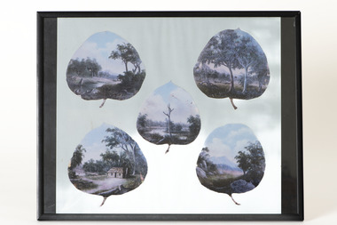 Chiltern Athenaeum Trust
Photograph - Reproduction
These copies of five oil on gum leaf paintings by Alfred William Eustace (1820-1907) display the subjects and detail of his small gum leaf paintings. A.W. Eustace, a well-known Australian artist, was born in Berkshire, England, where he was an assistant gamekeeper to the Earl of Craven at Ashdown Park. He migrated to Australia with his wife and children in 1851 and worked on the Ullina and Eldorado Runs on the Black Dog Creek at Chiltern, which was in excess of 50,000 acres of grazing land. A.W. Eustace was employed as a shepherd by Jason Withers and while tending his flocks in the solitude of the bush, Eustace turned his attention to painting and music to while away the long and weary hours. He endeavoured to capture the spirit of the bush and painted on board, canvas or tin plate, but as these materials were not always readily available he then started painting on large round eucalyptus leaves from the White and Red Box trees that grew around about him. He became known as the "Bush Artist." About 1856 he painted a small picture of the famous Woolshed goldrush and during the next few years became well known in North-East Victoria. John Sadlier, a police officer stationed at Beechworth said that Eustace painted 'some really exquisite scenes. He was of an easy-going dreamy temperament, a student of nature only, despising the works of men. Unfortunately his drawings were on eucalyptus leaves, the largest and roundest he could find and not on canvas, and no doubt have all perished long ago.' In 1876 the Melbourne Age newspaper reported, 'Eustace’s celebrated paintings on gum leaves are again attracting attention,…Mr Eustace is an elegant artist…he seems without effort to catch the colour and spirit of Australian scenery…' In 1864 A.W. Eustace held an Art Union in Albury, and again in 1884 in Ballarat. He exhibited at the Victorian Academy of Arts in 1877 and also held an exhibition of gum leaf paintings at Stevens Gallery, Melbourne in 1893. By 1896 he was receiving orders from heads of states in Europe, with his works acknowledged by Queen Victoria, Emperor Frederick of Germany and the Czar of Russia, as well as the Governors of New South Wales and Victoria. His paintings reflected his ability to paint the sky in his realistic style which is still noted by art critics of the day. A.W. Eustace was also a skillful taxidermist. The collection of birds and animals that can be seen at the Beechworth Museum are examples of his taxidermy skill. When not doing his work, painting or taxidermy, he regularly contributed letters and verse to the Chiltern newspaper, The Federal Standard. A book of verse in his hand writing was presented to The Athenaeum Trust by the Boadle family. In the 1870’s he became interested in spiritualism often being involved in lively debate at lectures and séances. Alfred William Eustace died in 1907 and is buried in the Chiltern New Cemetery with his wife Sarah and one of his daughters, Elizabeth.Alfred William Eustace was a well-known self-taught Australian artist who was known worldwide for her unique oil on gum leaf paintings. He was also a prominent Chiltern citizen.Copies of five A.W.Eustace oil paintings on gum leaf, under glass, displayed on blue paper in a black metal frame.alfred eustace, gum leaf painting, chiltern -
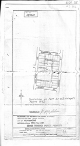 Whitehorse Historical Society Inc.
Document, Subdivision of part of W.B. Wickings Estate, 1952
Plan of subdivision of part of W.B. Wickings Estate, 1952. Reticulation area 1457, Sewer through private property. Melbourne and Metropolitan Board of Works document.land subdivision, holland road, blackburn south, constance street, gissing street, rosen street, wicking court, melbourne and metropolitan board of works, sewerage and sanitation, wicking, walter benjamin -
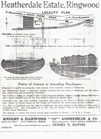 Whitehorse Historical Society Inc.
Document, Heatherdale Estate, Ringwood, 1919
Brochure advertising 52 lots, Heatherdale Estate, Ringwood (now Mitcham) to be auctioned September 1919.Brochure advertising 52 lots, Heatherdale Estate, Ringwood (now Mitcham) to be auctioned September 1919. Station Street on the plan is now Victory Street and a Railway Avenue is shown which does not now exist.Brochure advertising 52 lots, Heatherdale Estate, Ringwood (now Mitcham) to be auctioned September 1919.land subdivision, heatherdale estate, whitehorse road, mitcham, melbourne and metropolitan board of works, peers, w.h., coane, j.m., h.e., knight & harwood, godbehear & co, haynes, sydney t, walter street, witt street, victory street, purches, frederick walter