Showing 83 items
matching commissioner's buildings
-
 Bendigo Historical Society Inc.
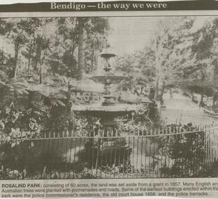
Newspaper - JENNY FOLEY COLLECTION: ROSALIND PARK
Bendigo Advertiser ''The way we were'' from 2000. Rosalind Park: consisting of 60 acres, the land was set aside from a grant in 1857. Many English and Australian trees were planted with promenades and roads. Some of the earliest buildings erected within this park were the police commissioner's residence, the old court house 1858 and the police barracks.. The clip is in a folder.newspaper, bendigo advertiser, the way we were -
 Bendigo Historical Society Inc.
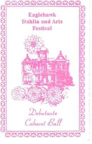
Document - EAGLEHAWK DAHLIA & ARTS FESTIVAL DEBUTANTE CABARET BALL, 16/03/1995
Three fold white card with pink printing. Card has border with a building and dahlias in the centre and Eaglehawk Dahlia and Arts Festival Debutante Cabaret Ball. The ball was held on two evenings, the first, the debutantes were presented to Commissioner Maxine Crouch and the second were presented to Commissioner Maurie Sharkey and Mrs. Carol Sharkey. The pianist was Mrs. Lorna Thomas. The Chaperones were Mrs. Heather Bull and Mrs. Gwen Harvey. The balls were held on Thursday, March16th, 1995 and Friday, March 17th, 1995. Card has rough surface.eaglehawk, eaglehawk dahlia and arts festival debutante cabaret ball, commissioner maxine crouch, commissioner maurie sharkey, mrs carol sharkey, mrs lorna thomas, mrs heather bull, mrs gwen harvey -
 Bendigo Historical Society Inc.
Document - MINING IN BENDIGO COLLECTION: DISCOVERY & BENDIGO HIGH SCHOOL
Copy of typed notes referring to who was the first to discover gold in Bendigo. Notes describe the area of Camp Hill which was selected as Government Headquarters. The sole remaining relic known as the Police Barracks, a brick stable which was converted into a small hall and the old Supreme Court building. Notes include the history of the Bendigo High School. Only pages 3 & 4.document, gold, mining in bendigo, mining in bendigo, gold discovery, bendigo high school, henry frencham, governor latrobe, gold commissioner horne, captain dane, mr cockburn, mr gilbert, queen elizabeth oval, police barracks building, superintendent mcculloch, high school, teachers' college, supreme court building, town council of sandhurst, corpporate high school, st andrew's college, sandhurst grammar school, bendigo continuation school, camp hill state school, school of mines, domestic arts school, quarry hill state school, congregational church, sir alexander peacock -
 Bendigo Historical Society Inc.
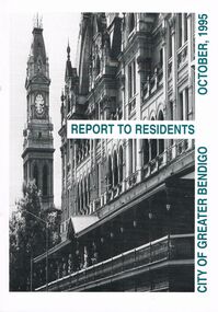
Book - BOOKLET: ''REPORT TO RESIDENTS CITY OF GREATER BENDIGO, OCTOBER 1995''
Front cover is a photo of The Shamrock Hotel. 52 paged booklet - ''Report to Residents - City of Greater Bendigo, October 1995''. Table of Contents; Commissioners; Chief Executive Officer; Council meetings; Office location and hours; ''One Telephone Number''; Committees; Ward boundaries; Elections; Customer services; Rural services; Economic development; Bendigo Tourism Board; Bendigo Trust; Events Bendigo; Capital works 1995/96; Major projects; Discovery; Bendigo Regional Arts Centre; local laws; Fire prevention; Aged and disability services; Children and family services; Environmental health; Recreation and leisure; Parks and gardens; Planning and building; Waste management; Library services; Bendigo Leisureland; Rates; Budget for 1995/96; Index. Contains some photographs and map of proposed 7 internal Wards for the City of Greater Bendigo.Richard Cambridge Printers Bendigo.bendigo, council, report, maxine crouch, maurie sharkey, perer ross-edwards, peter seamer, hadley sides, richard morriss, bernard smith, annie galvin child care centre, bendigo regional art centre, rosalind park, budget 1995/96. bendigo health care services. -
 Bendigo Historical Society Inc.
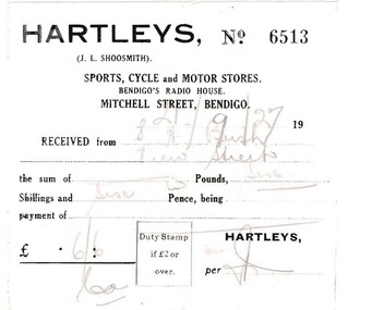
Document - BUSH COLLECTION: BUSINESS ACCOUNTS AND RECEIPTS, 1920 - 1930
Collection of approximately 74 accounts, 1925 - 1928, and receipts issued to S. A. Bush from various businesses in Bairnsdale and Bendigo. Invoices from: Hartleys, Mitchell Street, Bendigo. W. Rasmussen, for wood Bendigo Timber Co., Mollison Street and Williamson St. J. Kitchen & Sons Limited, Candle and soap manufacturers Stilwells, House furnishers, William Lunn, Painter, Pall Mall, Bendigo.Hargreaves Street, Bendigo W. McWiliams, wood merchant, 15 Milroy Street, Bendigo. Victorian Railways Commissioners, wood carting H.J. Fraser, A.N.A. building, View Street, Bendigo R.O Henderson, Beehive Pty Ltd., Pall Mall, Bendigo F.C. Cross, Furnishing, Andrew's Building, Hargreaves Street, Bendigo. Albert Bush's Produce Stores, Chaff Mills, Williamson Street, Bendigo. Bendigo Timber Coy. Mollison Street, Bendigo Buckell & Jeffrey, Railway Station, Bendigo C. Button, Carrier, 204 William Street, Bendigo. Furniture packed and stored. (invoice has photo of canvas covered cart. Written on side of cart' Furniture Packed and Stored, The Big Button' . ) W. Irving, House furnishing, 211 Mitchell Street, Bendigo Hartley's Bendigo, Len Shoosmith W. Koska, 297 Williamson Street Albert Bush's Stores, (next St. Paul's Tower) Williamson Street, Bendigo. W.J. Knight, Waggon and Lorry Builder, William Street, Bendigo William Lunn, Bendigo Glass, Pall Mall, Bendigo. Sandhurst and Northern District Trustees, Bendigo Cockings, Drapers, Pall Mall, Bendigo A. Fraser, 178 Carpenter Street, Bendigo W. Irving, furniture store, 211 Mitchell Street, Bendigo Myers, Pall Mall, Bendigo R.C. Eagle, wood merchant, Barnard Street, Bendigo W. McWilliams, wood merchant. W.H Osborn & Co., 130 Williamson Street, Bendigo Campbell & Connelly & Co., High Street, Bendigo H. McWilliams, cartage contractor, 15 Mitchell (?) Street Bendigo. H. Gray, 257 Barnard Street, Bendigo (Singer Sewing Machines) J.D. Allen, 'Whitehall" Sorrento (accommodation 4 weeks) W. McWilliams, for soil and sand.person, individual, bush collection - personal -
 Bendigo Historical Society Inc.
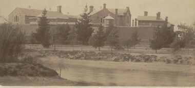
Photograph - BENDIGO GAOL, FROM COMMISSIONER'S GULLY, c.1880
Sepia photograph of the Bendigo Gaol looking across from Barnard Street, Mining dam in foreground. . Conifers along Northern bank of creek with gaol buildings in the background. All buildings are of masonry. Inscriptions: '37' in red ballpoint ink top RH corner. On back of mount: stamped in circle 'Royal Historical Society of Victoria, Bendigo Branch' In blue ballpoint ink above circly '1959' In red ballpoint ink above circle '37'. In blue ballpoint ink in one corner '1880'. Inclusions in storage envelope: Bendigo Gaol, J Lerk, 28/02/2000. The Bendigo Gaol looking across Commissioner's Gully c1880. The grey granite cell blocks contrast with the red brick exterior walls. Photograph courtesy Bendigo Historical Sociery (No. 136, texta on back). Machine printed inclusion worded as above entry. Another inclusion written in pencil states ' Bendigo Gaol about 1880. Granite from Big Hill was used to construct the cell blocks about 1860. Prisioners did not have heating, beds, seats or eating utensils. A public meeting in 1862 called for the debtor's quarters at the gaol to be lit with gas, handsomely furnished throughout and that inmates be provided with a bottle of wine, one bottle of brandy daily and tobacco and pipes availabe at liberty. (from Butcher, 'Annals of Bendigo 1862, Vol. 1, 76B).buildings, government, watch house, sandhurst -
Bendigo Historical Society Inc.
Document - HARRY BIGGS COLLECTION: MAP - BENDIGO
Document. Harry Biggs Collection. A very rough hand drawn map of Pall Mall area taking in Police Court, Survey Office, Dudley House, Stockade, Fire Brigade, Camp & commissioners Gully.place, building, public buildings, harry biggs collection, map, bendigo -
 Bendigo Historical Society Inc.
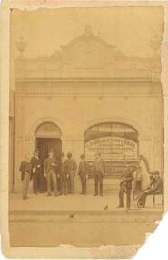
Photograph - BUILDING - CONNELLY & TATCHELL SOLICITORS, Late 1800's
Photograph - sepia - A group of men and a 2 man band, one with a violin and the other with a harp outside Connelly & Tatchell Solicitors building. Men wearing top hats and suits.Written in front window - Solicitors, Proctors and Conveyances. T.J.Connelly, A Commissioner for taking Afidavits, Victoria, New South Wales and New Zealand. Numbers written on back 2000-227-01.buildings, commercial, connelly & tatchell, connelly & tatchell solicitors. -
 Victorian Interpretive Projects Inc.
photograph, Opening of the bew building at Stratford Railway Station, Victoria, c1921, c1921
Stratford railway station is located on the Bairnsdale line in Victoria, Australia. The railway lined opened on 8 November 1887 it served the town of Stratford. The building at the Stratford Railway Station was opened around 1921 after the original building was destroyed by fire on 10 January 1920. "STRATFORD RAILWAY STATION. Mr. M'Lachlan, M.L.A., has received the following from Mr. Norman, late Chairman of the Railway Commissioners:-"In reply to yours, I beg to state that material for the new Stratford railway station has been ordered, and the work will be put in hand as soon as it has been delivered. It is not an easy matter at the present time to obtain materials, and I cannot say exactly when those required will be received." (Gippsland Times, 27 September 1920) Until their demolition, Munro, Fernbank, Lindenow and Hillside stations were located between Stratford and Bairnsdale stations. (wikipedia)Photograph of two postcards showing a crowd at Stratford Railway Station to celebrate the opening of the new building. stratford, stratford railway station, railway -
Tatura Irrigation & Wartime Camps Museum
Photographs Loaned, Charlie Hogan Estate photos
Photos loaned for copying. Collection of photos loaned from Estate of Charlie Hogan.|Photo 1.Mick Hogan; Mrs. Hogan & Charlie Hogan.|Photo 2. Nora Keane whose mother was a Hogan.|Photo 3. Mick Hogan & Thomas Flanagan snr,, Hilston, early 1900s.|Photo 4. Ray Glover; Norm Doncon, Charlie Hogan &Tom Cornish.|Photo 5. Ray Glover; Bill Mitchell &Tom Hunter.|Photo 6. James & Annie Brady. James son ofJames & Julia. Annie, dau. of Thomas & Annie Hogan.|Photo 7. Jack O'Toole & Charlie Hogan.|Photo 8. Georgie Hing, thought to have been the Chinese market gardener at the Whim Inn corner, and who was killed while riding his bike.|Photo 9. Hogan Street building of Stan Tudor & Kilpatrick & McLellan, stock and station agent. Building now owned by Dawes & Vary, Solicitors.|Photo 10 & 11. Tatura Coursing Club 1926. St. Ledger Plumpton Coursing won by Ryan Bros.|Photo 12 & 13. In two halves. Rodney Irrigation Trust Commissioners and staff, possibly in front of original Tatura Mechanics Institute building. (Mick Cussen third from left seated; Thomas Hogan white beard seated with legs crossed. Billie Wilson snr. standing at rear left side.)|Photo 14. Group in front of Catholic church, c. 1925, boy on left thought to be Charlie Hogan. -
 Robin Boyd Foundation
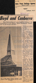
Newspaper - Clipping, News (Canberra), Boyd and Canberra, 18.10.1971
This article contains an announcement of Robin Boyd's death on Friday 16th October and gives a short summary his career, with emphasis on Canberra buildings and quote from Sir John Overall, Commissioner of the National Capital Development Commission.Grounds and Boyd written on top left in pencil. Their names underlines in text and caption.walsh st library -
 Westbourne Grammar Heritage Collection
Photograph - Mabel Molland at Monomeith 1962
This reproduction photograph was donated at a major reunion in 2008, organised by students of the school from the 1950s. It pictures Mabel Molland and a young student at Monomeith, home to the school since 1956. Monomeith is a Victorian Heritage Register listed (VHR number H0452), italianate styled brick villa, built in 1887 for one of Williamstown’s most important identities, James Styles. Styles’ distinguished career in public life included membership of the Williamstown Council, a stint in state parliament as the Member for Williamstown (1894-1900) and, in 1901, election to the first commonwealth parliament as a senator. During the 1890s he was also a commissioner of both the Melbourne Harbour Trust and the Melbourne and Metropolitan Board of Works and one of the trustees of the Williamstown Grammar School. The property comprises the residence designed by W Bennett Hall and built by James Styles in 1887 and the former migrant hostel buildings (now administration and classrooms), erected around 1951 by the then owner the Melbourne Harbour Trust, and intended to house migrant workers during the dredging of Port Phillip Bay. By the 1950s, the School had outgrown its home at Holy Trinity Hall and Mabel Molland reached out to Mr. Keith White, president of the Parent's Association and well-respected member of Williamstown Council for assistance. In 1956, following lengthy negotiations led by Mr. White, Monomeith was leased from the Melbourne Harbour Trust under a seven-year lease, which eventuated as a twenty-one year lease, followed by purchase of the property in 1972. Since then this historic building has come to be a much-loved symbol of the history of Westbourne Grammar School. This is a rare image of Mabel Molland at Monomeith, taken in the year prior to her retirement having taken over the school in 1914 and then set it on a path for the future as an incorporated company in the hands of a school council, with Mr Keith White as president, in 1956. Black and white reproduction photograph of a a residence (Monomeith) with steps in the middle ground, leading up to a verandah with ornate ironwork. Mabel Molland stands on the steps and a young student can be seen on the verandah. -
Koorie Heritage Trust
Book, Aboriginal Land Commissioner, Aboriginal Land Commissioner Report. Aboriginal Land Rights ( Northern Territory ) Act 1976 : Annual report, 1976
aboriginal land rights ( northern territory ) act 1976 -- aboriginal land commissioner -
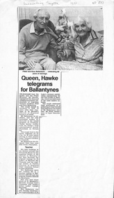 Whitehorse Historical Society Inc.
Newspaper - Article, Queen Hawke telegrams for Ballantynes, 1988
Extract from scrapbook of Mrs Jesse Williams. Celebration of the diamond wedding of Fred and Gene Ballantyne. Fred, an architect, was indentured to Walter Burley Griffin. Later buildings included Tintern CEGGS and St Luke's original vicarage. Gene taught mainly at Melbourne CEGGS and Tintern CEGGS and was also District Commissioner for Girl Guides in Boronia.williams, jessie, ballantyne, fred, gene, griffin, walter burley, 'plumstead' terrara road, vermont, st lukes anglican church -
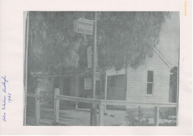 Rutherglen Historical Society
Image, c1965
Caption reads: "This is the Rutherglen police station, which was described as a 'disgrace' at Rutherglen Shire Council's meeting last Friday. Walls of the tiny station are riddled with white ants and the two lock-ups at the rear are primitive. The station is said to be more than 80 years old and entirely out of character with its surroundings -- the pleasant civic square. The condition of the buildings will be brought to the attention of the Victorian Police Commissioner and Public Works Department." The two lock-ups mentioned are now (2018) property of the Rutherglen Historical Society, and are located at the back of the Museum awaiting renovations to make them into a display.Black and white photocopy, that seems to have been from a newspaper article, showing a photograph of a small cottage that served as a police station in Rutherglen for some years. The photograph and its caption are printed on two sheets of paper.Written at the left side of the photo: "Police Station Rutherglen 1965" police station, rutherglen shire, cells, lock-up -
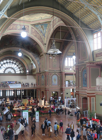
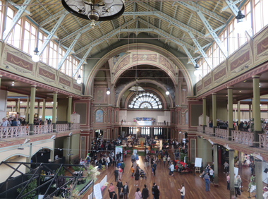 Ballarat Heritage Services
Photograph - Photograph -Colour, Clare Gervasoni, Interior of the Melbourne Exhibition Building, 2019, 31/03/2019
A competition was announced to design a suitable building for the proposed Melbourne International Exhibition in December 1877. Eighteen entries were received. The winner of 300 pounds was Joseph Reed of the architectual firm Reed and Barnes. The foundation stone was laid by Governor Sir George Bowen on 19 February 1879. Prominent Melbounre builder David Mitchell, father of Dame Nellie Melba, won the tender to construct the main building. Exhibitors were able to move in by May 1880. On 01 October 1880 the Melbourne International Exhibition opened, when over 6000 people entered the main hall to see the Governor, the Marquess of Normanby open the show. Thirty three nations participated and ofver 32,000 exhibits were displayed. At the close of the exhibition on 30 April 1881 over 1.3 million people had visited the exhibition. In 1881 Victoria's population was just over 250,000. The management of the Exhibition Building and eight hectares of the Carlton Gardens was handed to the Exhibition Trustees by the Melbourne International Exhibition Commissioners on 01 OCtober 1881. The Trustees maintained the building for 'future public exhibitions and ... general public instruction and recreation' until 1996 when management of the building was transferred to Museum Victoria. In 1901 when the Australian colonies federated there was no capital and no federal parliament building. The Federal Parliament moved into the Victorian State Parliament building, and the State Parliament moved into the Western Annexe of the Exhibition Building for 26 years. After World War One, on 04 February 1919, the exhibition Building was turned into a hospital to treat Melbournians struck down with the Spanis 'Flu'. Initially housing 500 beds, the hospital grew to accomodate 2000 patients. Femals were located between the concert platform in the western nave and the done; male patients occupied the spaces beyond. The basement was used a a morgue. With the departure of the State Parliament in 1927 the western annexe became home to the Country Roads Board. In 1932 it was joined by the MOtor Registration Branch, and the Transport Regulation Board in 1934. They co-existedin cramped offices until the 1960s. In 1949 the oval at the rear of the ExhibitionBuilding was leased to the Commonealth Government for the establishment of the Migrant Reception Centre. When it closed in 1961-62, the centre comrised 29 bungalows over 1.4 hectare. The centre provided temporary accomodation for thousands of new arrivals from Britain. On 01 July 2004 the Royal Exhibition Building and Carlton Gardens were inscribed on the World Heritage List. It is the only 19th century Great Hall to survive largely intact, still in its original landscape setting, and still used as a palace of industry. The Melbourne International Flower and Garden Show is a flower show held annually since 1995 in early April each year, in Melbourne, Australia. It is located in the World Heritage Site of Carlton Gardens and the Royal Exhibition Building.[1] It is the largest horticultural event in the southern hemisphere, attracting over 100,000 visitors. It is rated among the top five flower and garden shows in the world. (Wikipedia)Colour photograph of the interior of the Melbourne Exhibition Buildings during the 2019 Melbourne Flower and Garden Show.melbourne international flower and garden show, carlton gardens, melbourne exhibition building, royal exhibition buildings -
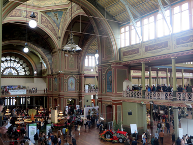 Ballarat Heritage Services
Photograph -Colour, Clare Gervasoni, Interior of the Melbourne Exhibition Building, 2019, 31/03/2019
A competition was announced to design a suitable building for the proposed Melbourne International Exhibition in December 1877. Eighteen entries were received. The winner of 300 pounds was Joseph Reed of the architectual firm Reed and Barnes. The foundation stone was laid by Governor Sir George Bowen on 19 February 1879. Prominent Melbounre builder David Mitchell, father of Dame Nellie Melba, won the tender to construct the main building. Exhibitors were able to move in by May 1880. On 01 October 1880 the Melbourne International Exhibition opened, when over 6000 people entered the main hall to see the Governor, the Marquess of Normanby open the show. Thirty three nations participated and ofver 32,000 exhibits were displayed. At the close of the exhibition on 30 April 1881 over 1.3 million people had visited the exhibition. In 1881 Victoria's population was just over 250,000. The management of the Exhibition Building and eight hectares of the Carlton Gardens was handed to the Exhibition Trustees by the Melbourne International Exhibition Commissioners on 01 OCtober 1881. The Trustees maintained the building for 'future public exhibitions and ... general public instruction and recreation' until 1996 when management of the building was transferred to Museum Victoria. In 1901 when the Australian colonies federated there was no capital and no federal parliament building. The Federal Parliament moved into the Victorian State Parliament building, and the State Parliament moved into the Western Annexe of the Exhibition Building for 26 years. After World War One, on 04 February 1919, the exhibition Building was turned into a hospital to treat Melbournians struck down with the Spanis 'Flu'. Initially housing 500 beds, the hospital grew to accomodate 2000 patients. Femals were located between the concert platform in the western nave and the done; male patients occupied the spaces beyond. The basement was used a a morgue. With the departure of the State Parliament in 1927 the western annexe became home to the Country Roads Board. In 1932 it was joined by the MOtor Registration Branch, and the Transport Regulation Board in 1934. They co-existedin cramped offices until the 1960s. In 1949 the oval at the rear of the ExhibitionBuilding was leased to the Commonealth Government for the establishment of the Migrant Reception Centre. When it closed in 1961-62, the centre comrised 29 bungalows over 1.4 hectare. The centre provided temporary accomodation for thousands of new arrivals from Britain. On 01 July 2004 the Royal Exhibition Building and Carlton Gardens were inscribed on the World Heritage List. It is the only 19th century Great Hall to survive largely intact, still in its original landscape setting, and still used as a palace of industry. The Melbourne International Flower and Garden Show is a flower show held annually since 1995 in early April each year, in Melbourne, Australia. It is located in the World Heritage Site of Carlton Gardens and the Royal Exhibition Building.[1] It is the largest horticultural event in the southern hemisphere, attracting over 100,000 visitors. It is rated among the top five flower and garden shows in the world. (Wikipedia)Colour photograph of the interior of the Melbourne Exhibition Buildings during the 2019 Melbourne Flower and Garden Show. Four mottoes are painted under teh windows of the dome: Dei Grecia (By the grace of God), Carpe diem (Make the most of the day), Aude sapere (Dare to be wise) and Benigno numine (With benighn power)melbourne international flower and garden show, carlton gardens, melbourne exhibition building, royal exhibition buildings -
 Ballarat Heritage Services
Photograph - Photograph -Colour, Clare Gervasoni, Interior of the Melbourne Exhibition Building, 2019, 31/03/2019
A competition was announced to design a suitable building for the proposed Melbourne International Exhibition in December 1877. Eighteen entries were received. The winner of 300 pounds was Joseph Reed of the architectual firm Reed and Barnes. The foundation stone was laid by Governor Sir George Bowen on 19 February 1879. Prominent Melbounre builder David Mitchell, father of Dame Nellie Melba, won the tender to construct the main building. Exhibitors were able to move in by May 1880. On 01 October 1880 the Melbourne International Exhibition opened, when over 6000 people entered the main hall to see the Governor, the Marquess of Normanby open the show. Thirty three nations participated and ofver 32,000 exhibits were displayed. At the close of the exhibition on 30 April 1881 over 1.3 million people had visited the exhibition. In 1881 Victoria's population was just over 250,000. The management of the Exhibition Building and eight hectares of the Carlton Gardens was handed to the Exhibition Trustees by the Melbourne International Exhibition Commissioners on 01 OCtober 1881. The Trustees maintained the building for 'future public exhibitions and ... general public instruction and recreation' until 1996 when management of the building was transferred to Museum Victoria. In 1901 when the Australian colonies federated there was no capital and no federal parliament building. The Federal Parliament moved into the Victorian State Parliament building, and the State Parliament moved into the Western Annexe of the Exhibition Building for 26 years. After World War One, on 04 February 1919, the exhibition Building was turned into a hospital to treat Melbournians struck down with the Spanis 'Flu'. Initially housing 500 beds, the hospital grew to accomodate 2000 patients. Femals were located between the concert platform in the western nave and the done; male patients occupied the spaces beyond. The basement was used a a morgue. With the departure of the State Parliament in 1927 the western annexe became home to the Country Roads Board. In 1932 it was joined by the MOtor Registration Branch, and the Transport Regulation Board in 1934. They co-existedin cramped offices until the 1960s. In 1949 the oval at the rear of the ExhibitionBuilding was leased to the Commonealth Government for the establishment of the Migrant Reception Centre. When it closed in 1961-62, the centre comrised 29 bungalows over 1.4 hectare. The centre provided temporary accomodation for thousands of new arrivals from Britain. On 01 July 2004 the Royal Exhibition Building and Carlton Gardens were inscribed on the World Heritage List. It is the only 19th century Great Hall to survive largely intact, still in its original landscape setting, and still used as a palace of industry. The Melbourne International Flower and Garden Show is a flower show held annually since 1995 in early April each year, in Melbourne, Australia. It is located in the World Heritage Site of Carlton Gardens and the Royal Exhibition Building.[1] It is the largest horticultural event in the southern hemisphere, attracting over 100,000 visitors. It is rated among the top five flower and garden shows in the world. (Wikipedia)Colour photograph of the interior of the Melbourne Exhibition Buildings during the 2019 Melbourne Flower and Garden Show. Four mottoes are painted under teh windows of the dome: Dei Grecia (By the grace of God), Carpe diem (Make the most of the day), Aude sapere (Dare to be wise) and Benigno numine (With benighn power)melbourne international flower and garden show, carlton gardens, melbourne exhibition building, royal exhibition buildings -
 Whitehorse Historical Society Inc.
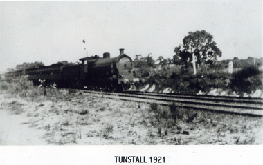
Photograph, Tunstall 1921
Tunstall was named after a town in England of the same name because of the similarity of the clay. In 1945 Cr. Knox moved 'that the name of the district known as Tunstall be altered to Nunawading and the council requests that the Post Master General's Department, the Victorian Railway Commissioners and any other department concerned , give affect to such change'. This was seconded by Cr. Savage and carried unanimously.Black and white photograph of a train on lines near Tunstall. No buildings.tunstall 1921, railways -
 Ballarat Heritage Services
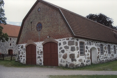
Photograph - Digital photograph, Denise Kinnane, Barn at Rabelofs, Sweden, 2007
The barn is situated near Råbelöv castle, and near the small medieval church adjacent to the property, that is a popular baptismal and wedding church. Råbelöv Castle is a castle in Kristianstad Municipality, Scania, in southern Sweden. The castle was built in 1637. In this year, Christopher Ulfeld Råbelöf's current main building, his and his wife's initials were still on the north end. He died in 1657 and was succeeded at Råbelöf first by his son Björn, then by his nephew Otto. Both died young, whereby Christopher's son Ebbe, married to Hedewig, daughter of Christian IV and his second wife, Kirsten Munck, took office in 1663. In 1676 - 1678 Kristianstad was held by the Danes, but was besieged by Charles XI. The siege staff were located at Råbelöf, both on the enclosed yard and on a moat surrounded by a islet just west of the farm. During this time, Råbelöf was held by Ebbe's daughter Anna Catharina, married to Carl Gustaf Skytte. The latter settled for a time in 1712 on the fortified island within the moat to protect himself from the then ravaging plague. From the Skåne trip in 1749, Linnaeus describes homes and a lovely garden with mulberry and walnut trees, grapes, lavender and white lilies in abundance. The owner was then Anna Catharina Ridderschantz, married to Ludvig Gustaf von Böhnen. She made 1763 Råbelöf and Odersberga fidei committee for the benefit of her three daughters. The Fidei Commission letter is difficult to interpret when it comes to the time after the three daughters, something that several times caused bitter heritage disputes. In 1782 the entire farm burned, the main building was badly damaged and the family moved to Råbelöf belonging to Odersberga, which then had completely new buildings, those that are still there today. Only in 1833 then did the fidei commissioner Fredrik von Rosen return to Råbelöf. The main building had then been cut down and fitted with a new south gable. According to fidei commission rules, Råbelöf returned to the von Böhnen family in 1864. Accession did not become presumed Celestine von Böhnen but instead her older brother Axel. Celestine was married to John William Kennedy. The fide commission went to her and John Williams son James Kennedy. The family could then look back on a number of tortuous legal proceedings between John William and his wife Celestine on the one hand and Axel and his wife Elsa Maria on the other. James was a chamberlain, sitting in the first chamber where he fought socialism. This led to the large agricultural workers' strike in 1907 that was concentrated on Kennedy's three farms Råbelöf, Odersberga and Hammarsjö. In 1906, his eldest son Douglas, the future fidei commissioner, took his life. Four years later another son took his life. James and his wife took the disasters hard, they fell ill. The young son Gilbert got in 1908, only 22 years old, took over responsibility for the farm. James son Gilbert Kennedy took over as Fidei Commissioner in 1916 and they became known as outstanding farmers with, among other things, grazing for dairy cows and fruit growing as specialties. He passed away in 1946 and was succeeded by his son Douglas, who gave continuity to Råbelöf's position with among other things, a new barn with loose running and slatted floors in 1965. Douglas Kennedy held the farm 61 years before he passed away in 2007. He became the last fidei commissioner, the property became a fideicommissie corporation inherited by his sister-in-law John Murray, who in turn in 2010 left it his children Caroline Murray Karlsson and Johan Murray. Since October 2014, Johan Murray has been the sole owner.Digital photograph of a Barn at Rabelofs, Swedenkristianstadt, kennedy, sweden, råbelöv, church, castle, barn -
 Old Colonists' Association of Ballarat Inc.
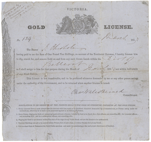
Document - Gold License, Gold License issued to John Chisholm
This miner's right was glued onto a page in a large album of photographic images of early Ballarat. Recognising their significance the Council of the Old Colonists’ Association of Ballarat Inc. had them removed and restored. The originals are now framed and on display in the Old Colonists’ Hall.Victorian Gold License made out to John Chisholm.Ballarat Victoria Gold License No. 139 March 1853 The Bearer J. Chisholm having paid to me the Sum of One Pound Ten Shillings, on account of the territorial revenue, I hereby License him to dig, search for, and remove Gold on and from any such Crown lands within the Dist of Ballarat as I shall assign to him for that purpose during the month of march 1853 not within half-a-mile of any Head Station, This License is not transferable, and to be produced whenever demanded by me or any other person acting under the authority of the Government, and to be returned when another License is issued. Chas Wale Sherard Commissioner. Regulations to be observed by the persons digging for Gold or otherwise employed at the Gold fields. 1. Every licensed person must always have his License with him ready to be produced whenever demanded by a Commissioner, or Person acting under instructions, otherwise he is liable to be proceeded against as an unlicensed person. 2. Every person digging to Gold, or occupying Land, without a License is liable by law to be fined, for a first offence, not exceeding five pounds; for a second offence not exceeding 15 pounds; and for subsequent offence, not exceeding 30 pounds. 3. Digging for Gold is not allowed within ten feet of the edge of any Public Road, nor are the roads to be undermined. 4. Tents or Buildings are not to be erected within twenty feet of each other, or within 20 feet of any Creek 5. It is enjoined that all persons on the Gold Fields maintain a due and proper observance of Sundays. Handwritten in top left corner 'Presented by D.M.D. Main. 12 Dundas St. Dunedin N.Z. 30.8.21chisholm, sherard, charles sherard, john chisholm, mining, main, d.m.d. main -
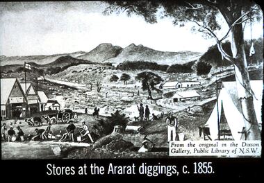 Bendigo Historical Society Inc.
Slide - DIGGERS & MINING. STORES AT THE DIGGINGS, c1855
Diggers & Mining. Stores at the diggings. Stores at the Ararat diggings, c. 1855. From the original in the Dixon Gallery, Public Library of NSW. Slide depicts the scene at the goldfields with the Commissioners huts and in the background there are other buildings. On the Gold field there is a man on a horse, a man with a heavily laden cart being pulled by 4 ox. Some men are working in the gully for gold, panning, using cradle. In the front centre at the bottom is the head and shoulders of a man with an axe digging out his mine. There are also some dogs in the picture and a tent in the front right corner. Markings: 12 994.LIF. 5. Used as a teaching aid.hanimounteducation, tertiary, goldfields -
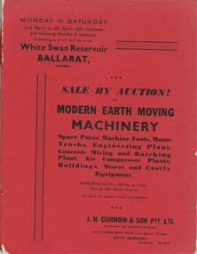 Bendigo Historical Society Inc.
Document - IAN DYETT COLLECTION: AUCTION CATALOGUE - WHITE SWAN RESERVOIR
Three auction catalogues, two with red covers and the third is missing the cover. Sale of Earth Moving Machinery. Spare Parts, Machine Tools, Motor Trucks, Engineering Plant, Concrete Mixing and Batching Plant, Air Compressor Plants, Buildings, Stores and Costly Equipment on 31st March to 5th April 1952 (inclusive) at the White Swan Reservoir, Ballarat, Victoria. J. H. Curnow & Son Pty. Ltd. Were the auctioneers. Included in the catalogue is a Locality Plan showing location of lot areas - access roads, etc. Page 4 has a black and white photo showing Super c Tournapull, Lot 63 and Tractor hauling 12-15 cub. Yd. capacity scoop. Page 9 photo is Lot 209, a Sheep's Foot Roller, Page 12 photo is Lots 258, 259 & 260 - Class 1 tractor hauling two 12-15 c yd Te Tourneau Scrapers, and page 68 has a black & white photo of Lot 2377, the Concrete Batching Plant.business, auctioneers, j h curnow & son pty ltd, ian dyett collection - auction catalogue - white swan reservoir, the ballarat water commissioners, j h curnow & son pty ltd, prahran telegraph printing co -
 Bendigo Historical Society Inc.
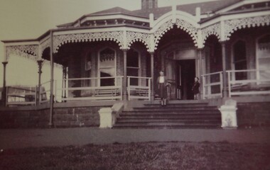
Document - Bendigo Home and Hospital for the Aged, 1860-1970s
The inaugruration of the newly erected Benevolant Asylum took place on 15th March 1860. The asylum is situated on the west side of Commissioner's Gully, Barnard Street, Bendigo. The building itself is the design of Mr Robert A. Love, Architect, the Contractor is Mr Crawford and the Clerk of Works, Mr Wrigley. - from the Bendigo Advertiser 16th March 1860. In the Advertiser Dec 20 1872: the Memorial Stone was added and the design for the front elecvation was carried out as origionally planned with 12 columns of brick and cement each 36 feet high, the bases of which are granite. Typed History of the hospital, and letters regarding classification status and two A4 sized photos of the front of the building.history, national trust bendigo collection, bendigo, benevolant home bendigo, benevolant asylum bendigo, home and hospital for the aged bendigo, ann caudle centre bendigo -
 Bendigo Historical Society Inc.
Slide - Images by Arthur Pulfer, 1957-1970
ROSEVIEW 407 High Street, Golden Square Bendigo "Roseview" was designed by Godfrey Eathorne and constructed in 1939. It is one of the few Streamline Moderne houses in the Central Goldfields region, and was one of the earliest constructed in the Bendigo region. It is an outstanding example of this style of housing. It resembles an ocean liner, and reflects the emphasis on the streamlining of methods of transportation. It utilizes both flat and curved surfaces and has little external ornamentation. The use of materials such as rounded glass windows and metal window and door frames reflects an innovative approach to construction consistent with the style. "Roseview" was constructed on a large scale, with large and spacious rooms. It reflects the prominent social status and wealth of the original owner, together with the desire for a building in 'the latest' style which was sure to attract attention and prominence in the region. It has been maintained largely in original condition. CARALULUP HOTEL 'The Sun' dated January 17, 1941 on the back. It states that 'The licence of Caralulup Hotel, near Talbot, has been surrendered, thus severing an 80 year association with the district' State Library of Victoria TOLMER GOLD ESCORT ROUTE The gold rush in New South Wales and Victoria left few able miners in South Australia. Bad economic conditions saw more than 15,000 men leave the Kapunda and Burra mines by the end of 1851. Alexander Tolmer, Commissioner of Police in 1852 proposed that the gold won by South Australians should be brought back to South Australia under an escort consisting of only a few men. In March a Gold Escort was on its way back to Adelaide with almost 6,000 ounces of gold for the vaults of the Treasury Building. After this successful trip Tolmer led two other escorts before handing over his duties. A total of eighteen gold escorts were made, the last one during November and December 1853 when Inspector Wyndham was in charge. You’ll find Gold Escort Route Monuments between Meningie, Coonalpyn and Tintinara.Many images from by Arthur Pulfer copied to slides. Twenty Slides of Bendigo: Bullen's Circus Bendigo February 1966 "Roseview", Pethard's Home at 407 High Street, Golden Square, Bendigo. 25th March 1957. House is possibly on the Midland Highway Epsom, Bendigo - 8 April 1955 Kangaroo Flat Bus Lines mini bus The Big Tree Sedgwick Road March 1972 The old Golden Gully Hotel Diamond Hill Road, Bendigo The old Lockup Eaglehawk Bendigo September 1967 Market Gardens - possibly North Bendigo North Deborah Mine photo taken from Breen Street 1958 Laying the track to get the engine into the park, looking down Mitchell Street Bendigo Engine R766 in the Victorian Railways Institute Park Railway Place Bendigo On the Methodist Church Steps Arnold street Bendigo Miner's Hut at Moliagul Basket Lunch - White Hills Botanical Gardens - St johns 100 year celebrations White Hills Swimming Pool February 1970 White Hills Botanical Gardens Bendigo Bendigo Show Parade 1958 The Arrival of the Cobb and Co Coach in Bendigo September 1963 history, bendigo, james lerk collection, golden square high school, dragon loong, white hill botanical gardens, 407 high street bendigo, r766 engine, bullens circus, caralulup, moligual, bendigo show, tolmer's gold route, kangaroo flat bus lines, eaglehawk lockup, arnold street methodist church, elephants -
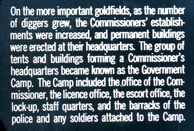 Bendigo Historical Society Inc.
Slide - DIGGERS & MINING. THE GOLD LICENCE, C1850s
... of tents and buildings forming a Commissioner's headquarters became... at their headquarters. The group of tents and buildings forming a Commissioner's ...Diggers & Mining. The gold licence. The Government Camp. Slide: On the more important goldfields, as the number of diggers grew, the Commissioners' establishments were increased, and permanent buildings were erected at their headquarters. The group of tents and buildings forming a Commissioner's headquarters became known as the Government Camp. The Camp included the office of the Commissioner, the licence office, the escort office, the lock-up, staff quarters, and the barracks of the police and any soldiers attached to the Camp. Markings: 14 994.LIF. 4. Used as a teaching aid.hanimounteducation, tertiary, goldfields -
 Bayside Gallery - Bayside City Council Art & Heritage Collection
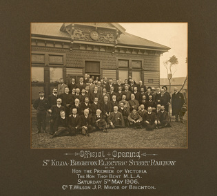
Photograph - sepia photograph, Official Opening, St Kilda - Brighton Electric Street Railway, 1906
electric street railway, public transport, st kilda, brighton, mayor, councillors, thomas bent, premier, opening, celebration, cr. t. wilson, cr. h.b. gibbs, hon. d.e. mcbryde, mr goddard, mr j.n. browne, town clerk, mr bradford, electrical engineer, mr tait, railways commissioner, hon. j.c. campbell, mr rees, mr r.g. mccutcheon, sepia, photograph, tram -
 Kew Historical Society Inc
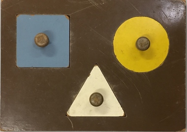
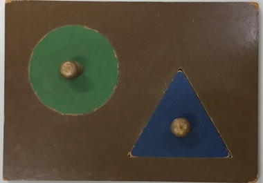
Leisure object, Child's Puzzle : Denmark Street Baby Health Centre, c.1950s
In August, 1920, The Kew Town Council decided to establish a Baby Health Centre in Kew. The first Centre was opened in a room in the Town Hall in Walpole Street on 5 November 1920. In May 1939, the Railway Commissioners agreed to lease a site at the Kew Railway Station for a Baby Health Centre for a term of 21 years at 3 pounds per annum. A building, designed by Roland Chipperfield, was erected, and the Centre previously conducted at the Town Hall transferred there. This became known as the Denmark Street Baby Health Centre. (Cr. W.D. Vaughan, Kew’s Civic Century, W.D. Vaughan Pty Ltd., Kew, 1960, pp.96 & 97.)One of a pair of wooden puzzles used in the Denmark Street Baby Health Centre in Kew.denmark street baby health centre - kew (vic), baby health centres - kew (vic), games and puzzles -
 Kew Historical Society Inc
Leisure object, Child's Puzzle : Denmark Street Baby Health Centre, c.1950s
In August, 1920, The Kew Town Council decided to establish a Baby Health Centre in Kew. The first Centre was opened in a room in the Town Hall in Walpole Street on 5 November 1920. In May 1939, the Railway Commissioners agreed to lease a site at the Kew Railway Station for a Baby Health Centre for a term of 21 years at 3 pounds per annum. A building, designed by Roland Chipperfield, was erected, and the Centre previously conducted at the Town Hall transferred there. This became known as the Denmark Street Baby Health Centre. (Cr. W.D. Vaughan, Kew’s Civic Century, W.D. Vaughan Pty Ltd., Kew, 1960, pp.96 & 97.)One of a pair of wooden puzzles used in the Denmark Street Baby Health Centre in Kew.denmark street baby health centre - kew (vic), baby health centres - kew (vic), games and puzzles -
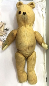 Kew Historical Society Inc
Leisure object, Teddy Bear, 1930-1955
In August, 1920, The Kew Town Council decided to establish a Baby Health Centre in Kew. The first Centre was opened in a room in the Town Hall in Walpole Street on 5 November 1920. In May 1939, the Railway Commissioners agreed to lease a site at the Kew Railway Station for a Baby Health Centre for a term of 21 years at 3 pounds per annum. A building, designed by Roland Chipperfield, was erected, and the Centre previously conducted at the Town Hall transferred there. This became known as the Denmark Street Baby Health Centre. (Cr. W.D. Vaughan, Kew’s Civic Century, W.D. Vaughan Pty Ltd., Kew, 1960, pp.96 & 97.)Small teddy bear with only one eye remaining and with a number of repairs. The bear was used by children at the Denmark Street Baby Health Centre in Kew.toys - teddy bears, denmark street baby health centre - kew (vic)