Showing 72 items
matching frank grove
-
 Eltham District Historical Society Inc
Photograph, Stokes family, Nyora Road, Eltham, c.1952, 1952c
Taken from outside the family home on the southest corner of the intersection of Nyora Road and Pitt Street with Eucalyptus Road, looking northeast across the Stokes Orchard L-R: David, Howard, Beryl (kneeling), Dorothy and Gladys Stokes with Gladys's mother sitting in Gladys's father's car with Spot the dog, Nyora Road, Eltham, c.1952 Frank Stokes first traveled to the district by train in 1944 to find land with the intention to establish an orchard. By chance he met Arthur Bird of Bird Orchard (bounded by Pitt Street, Eucalyptus Road and Wattle Grove) and they got talking over their common interest. Arthur put Frank up for the night and pointed out the land, part of Crown Allotment 15, Section 5, Parish of Nillumbik (CA15) somewhat diagonally opposite Bird Orchard. Frank bought the land and for the next two years would travel by train from Melbourne to Eltham every weekend establishing Stokes Orchard and building a home for his family, which they eventually moved into in 1946. In the mid 1970s the Shire of Eltham divided the orchard up into numerous rate-able parcel lots, which became affordable for Frank. As a consequence Stokes Orchard was turned into a housing development by Macquarie Builders and marketed as the Stokes Orchard Estate in two stages; Stage 1 encompassing Scarlet Ash Court, Ironbark Close and Peppermint Grove bounded by Nyora and Eucalyptus roads c.1976 and Stage 2 encompassing Stokes Place, Orchard Way, The Crest and The Lookout bound by Nyora and Diosma roads c.1979. The development of Orchard Way, The Crest and The Lookout did not proceed as planned due to the lack of the sewer along Diosma Road and so many of the proposed lots were incorporated into five-acre parcels instead.Representative of the orchard growing areas of ElthamDigital file only - Digitised by EDHS from a scrapbook (containing commercially printed photos of digital scans) on loan from Beryl Bradbury (nee Stokes), daughter of Frank Stokes.1948-1951 vauxhall velox, 1948-1951 vauxhall wyvern, 1952, beryl bradbury (nee stokes), beryl bradbury (nee stokes) collection, david stokes, dorothy stokes, eltham, gladys stokes, nyora road, spot (dog), stokes orchard -
 Eltham District Historical Society Inc
Photograph, Stokes family with horse and sled, Nyora Road, Eltham, c.1950, 1950c
Taken from outside the family home on the southest corner of the intersection of Nyora Road and Pitt Street with Eucalyptus Road, looking northeast across the Stokes Orchard Frank Stokes with children, Dorothy (left), Beryl and David Frank Stokes first traveled to the district by train in 1944 to find land with the intention to establish an orchard. By chance he met Arthur Bird of Bird Orchard (bounded by Pitt Street, Eucalyptus Road and Wattle Grove) and they got talking over their common interest. Arthur put Frank up for the night and pointed out the land, part of Crown Allotment 15, Section 5, Parish of Nillumbik (CA15) somewhat diagonally opposite Bird Orchard. Frank bought the land and for the next two years would travel by train from Melbourne to Eltham every weekend establishing Stokes Orchard and building a home for his family, which they eventually moved into in 1946. In the mid 1970s the Shire of Eltham divided the orchard up into numerous rate-able parcel lots, which became affordable for Frank. As a consequence Stokes Orchard was turned into a housing development by Macquarie Builders and marketed as the Stokes Orchard Estate in two stages; Stage 1 encompassing Scarlet Ash Court, Ironbark Close and Peppermint Grove bounded by Nyora and Eucalyptus roads c.1976 and Stage 2 encompassing Stokes Place, Orchard Way, The Crest and The Lookout bound by Nyora and Diosma roads c.1979. The development of Orchard Way, The Crest and The Lookout did not proceed as planned due to the lack of the sewer along Diosma Road and so many of the proposed lots were incorporated into five-acre parcels instead.Representative of the orchard growing areas of ElthamDigital file only - Digitised by EDHS from a scrapbook (containing commercially printed photos of digital scans) on loan from Beryl Bradbury (nee Stokes), daughter of Frank Stokes.1950, beryl bradbury (nee stokes), beryl bradbury (nee stokes) collection, david stokes, dorothy stokes, eltham, frank stokes, horse, nyora road, sled, stokes orchard -
 Eltham District Historical Society Inc
Photograph, The Stokes family home blanketed with snow, corner Nyora and Eucalyptus roads, Eltham, winter 1951, 1951
Taken from outside the family home on the southest corner of the intersection of Nyora Road and Pitt Street with Eucalyptus Road. Frank Stokes first traveled to the district by train in 1944 to find land with the intention to establish an orchard. By chance he met Arthur Bird of Bird Orchard (bounded by Pitt Street, Eucalyptus Road and Wattle Grove) and they got talking over their common interest. Arthur put Frank up for the night and pointed out the land, part of Crown Allotment 15, Section 5, Parish of Nillumbik (CA15) somewhat diagonally opposite Bird Orchard. Frank bought the land and for the next two years would travel by train from Melbourne to Eltham every weekend establishing Stokes Orchard and building a home for his family, which they eventually moved into in 1946. In the mid 1970s the Shire of Eltham divided the orchard up into numerous rate-able parcel lots, which became affordable for Frank. As a consequence Stokes Orchard was turned into a housing development by Macquarie Builders and marketed as the Stokes Orchard Estate in two stages; Stage 1 encompassing Scarlet Ash Court, Ironbark Close and Peppermint Grove bounded by Nyora and Eucalyptus roads c.1976 and Stage 2 encompassing Stokes Place, Orchard Way, The Crest and The Lookout bound by Nyora and Diosma roads c.1979. The development of Orchard Way, The Crest and The Lookout did not proceed as planned due to the lack of the sewer along Diosma Road and so many of the proposed lots were incorporated into five-acre parcels instead.Representative of the orchard growing areas of Eltham. One of the rare times it has snowed in ElthamDigital file only - Digitised by EDHS from a scrapbook (containing commercially printed photos of digital scans) on loan from Beryl Bradbury (nee Stokes), daughter of Frank Stokes.1951, beryl bradbury (nee stokes) collection, eltham, eucalyptus road, nyora road, snow, stokes family home -
 Eltham District Historical Society Inc
Photograph, The Stokes family home and orchard blanketed with snow, corner Nyora and Eucalyptus roads, Eltham, Winter 1951, 1951
Taken from outside the family home on the southest corner of the intersection of Nyora Road and Pitt Street with Eucalyptus Road. Frank Stokes first traveled to the district by train in 1944 to find land with the intention to establish an orchard. By chance he met Arthur Bird of Bird Orchard (bounded by Pitt Street, Eucalyptus Road and Wattle Grove) and they got talking over their common interest. Arthur put Frank up for the night and pointed out the land, part of Crown Allotment 15, Section 5, Parish of Nillumbik (CA15) somewhat diagonally opposite Bird Orchard. Frank bought the land and for the next two years would travel by train from Melbourne to Eltham every weekend establishing Stokes Orchard and building a home for his family, which they eventually moved into in 1946. Marjorie North remembered well the winter of 1951, when she took children, including son John together with the Shallard and Squire children “in the Austin A40 up the Main Rd., Eltham to farmer Bell’s property alongside the Eltham College. They were able to make a snow man and throw snowballs. (Diamond Valley News, August 5, 1986.p.42) In the mid 1970s the Shire of Eltham divided the orchard up into numerous rate-able parcel lots, which became affordable for Frank. As a consequence Stokes Orchard was turned into a housing development by Macquarie Builders and marketed as the Stokes Orchard Estate in two stages; Stage 1 encompassing Scarlet Ash Court, Ironbark Close and Peppermint Grove bounded by Nyora and Eucalyptus roads c.1976 and Stage 2 encompassing Stokes Place, Orchard Way, The Crest and The Lookout bound by Nyora and Diosma roads c.1979. The development of Orchard Way, The Crest and The Lookout did not proceed as planned due to the lack of the sewer along Diosma Road and so many of the proposed lots were incorporated into five-acre parcels instead.Representative of the orchard growing areas of Eltham. One of the rare times it has snowed in Eltham.Digital file only - Digitised by EDHS from a scrapbook (containing commercially printed photos of digital scans) on loan from Beryl Bradbury (nee Stokes), daughter of Frank Stokes.1951, beryl bradbury (nee stokes) collection, eltham, nyora road, eucalyptus road, snow, stokes family home -
 Eltham District Historical Society Inc
Photograph, The first houses in construction on the new Stokes Orchard Estate, July 1976, July 1976
... with Peppermint Grove in the distance. Frank Stokes first traveled... with Peppermint Grove in the distance. Frank Stokes first traveled ...Viewed from near the Stokes family home at 1 Nyora Road looking northeast across Ironbark Close to Scarlet Ash Court with Peppermint Grove in the distance. Frank Stokes first traveled to the district by train in 1944 to find land with the intention to establish an orchard. By chance he met Arthur Bird of Bird Orchard (bounded by Pitt Street, Eucalyptus Road and Wattle Grove) and they got talking over their common interest. Arthur put Frank up for the night and pointed out the land, part of Crown Allotment 15, Section 5, Parish of Nillumbik (CA15) somewhat diagonally opposite Bird Orchard. Frank bought the land and for the next two years would travel by train from Melbourne to Eltham every weekend establishing Stokes Orchard and building a home for his family, which they eventually moved into in 1946. In the mid 1970s the Shire of Eltham divided the orchard up into numerous rate-able parcel lots, which became affordable for Frank. As a consequence Stokes Orchard was turned into a housing development by Macquarie Builders and marketed as the Stokes Orchard Estate in two stages; Stage 1 encompassing Scarlet Ash Court, Ironbark Close and Peppermint Grove bounded by Nyora and Eucalyptus roads c.1976 and Stage 2 encompassing Stokes Place, Orchard Way, The Crest and The Lookout bound by Nyora and Diosma roads c.1979. The development of Orchard Way, The Crest and The Lookout did not proceed as planned due to the lack of the sewer along Diosma Road and so many of the proposed lots were incorporated into five-acre parcels instead.Housing development in Eltham as an extension to the Woodridge EstateDigital file only - Digitised by EDHS from a scrapbook (containing commercially printed photos of digital scans) on loan from Beryl Bradbury (nee Stokes), daughter of Frank Stokes.1976-07, beryl bradbury (nee stokes) collection, building construction, ironbark close, nyora road, peppermint grove, scarlet ash court, stokes orchard estate, houses -
 Eltham District Historical Society Inc
Photograph, Looking south towards Nyora Road, Eltham, 1977, 1977
Viewed from near the end of Stokes Place where the linear reserve now runs between 8 and 9 Stokes Place just visible through trees in foreground, 24 Nyora with red roof is the first house in middle of view. Frank Stokes first traveled to the district by train in 1944 to find land with the intention to establish an orchard. By chance he met Arthur Bird of Bird Orchard (bounded by Pitt Street, Eucalyptus Road and Wattle Grove) and they got talking over their common interest. Arthur put Frank up for the night and pointed out the land, part of Crown Allotment 15, Section 5, Parish of Nillumbik (CA15) somewhat diagonally opposite Bird Orchard. Frank bought the land and for the next two years would travel by train from Melbourne to Eltham every weekend establishing Stokes Orchard and building a home for his family, which they eventually moved into in 1946. In the mid 1970s the Shire of Eltham divided the orchard up into numerous rate-able parcel lots, which became affordable for Frank. As a consequence Stokes Orchard was turned into a housing development by Macquarie Builders and marketed as the Stokes Orchard Estate in two stages; Stage 1 encompassing Scarlet Ash Court, Ironbark Close and Peppermint Grove bounded by Nyora and Eucalyptus roads c.1976 and Stage 2 encompassing Stokes Place, Orchard Way, The Crest and The Lookout bound by Nyora and Diosma roads c.1979. The development of Orchard Way, The Crest and The Lookout did not proceed as planned due to the lack of the sewer along Diosma Road and so many of the proposed lots were incorporated into five-acre parcels instead.Housing development in Eltham as an extension to the Woodridge EstateDigital file only - Digitised by EDHS from a scrapbook (containing commercially printed photos of digital scans) on loan from Beryl Bradbury (nee Stokes), daughter of Frank Stokes.1977, beryl bradbury (nee stokes) collection, nyora road, stokes orchard estate, stokes place -
 Eltham District Historical Society Inc
Photograph, Stokes Place, Eltham, July 1977, July 1977
Viewed from near the end of Stokes Place where the linear reserve now runs between 8 and 9 Stokes Place looking slightly east of south towards Nyora Road. The new Christian Church on Nyora now the Baptist Church visible in middle view. Frank Stokes first traveled to the district by train in 1944 to find land with the intention to establish an orchard. By chance he met Arthur Bird of Bird Orchard (bounded by Pitt Street, Eucalyptus Road and Wattle Grove) and they got talking over their common interest. Arthur put Frank up for the night and pointed out the land, part of Crown Allotment 15, Section 5, Parish of Nillumbik (CA15) somewhat diagonally opposite Bird Orchard. Frank bought the land and for the next two years would travel by train from Melbourne to Eltham every weekend establishing Stokes Orchard and building a home for his family, which they eventually moved into in 1946. In the mid 1970s the Shire of Eltham divided the orchard up into numerous rate-able parcel lots, which became affordable for Frank. As a consequence Stokes Orchard was turned into a housing development by Macquarie Builders and marketed as the Stokes Orchard Estate in two stages; Stage 1 encompassing Scarlet Ash Court, Ironbark Close and Peppermint Grove bounded by Nyora and Eucalyptus roads c.1976 and Stage 2 encompassing Stokes Place, Orchard Way, The Crest and The Lookout bound by Nyora and Diosma roads c.1979. The development of Orchard Way, The Crest and The Lookout did not proceed as planned due to the lack of the sewer along Diosma Road and so many of the proposed lots were incorporated into five-acre parcels instead.Housing development in Eltham as an extension to the Woodridge EstateDigital file only - Digitised by EDHS from a scrapbook (containing commercially printed photos of digital scans) on loan from Beryl Bradbury (nee Stokes), daughter of Frank Stokes.1977-07, beryl bradbury (nee stokes) collection, eltham, eltham christian church, stokes orchard estate, stokes place -
 Eltham District Historical Society Inc
Film - Video (DVD), Frank Stokes, Stokes Family, 1950-1977
Various family scenes taken from outside the family home on the southeast corner of the intersection of Nyora Road and Pitt Street with Eucalyptus Road. Also, scenes of the Stokes Orchard and equipment used, construction of water reservoir at the end of Nyora Road near Reynolds Road and Diosma Road as well as early stages of the Stokes Orchard housing development. Frank Stokes worked as a qualified accountant at Kennons leather factory in Burnley, while living at 1 Thomas Street, Mitcham. He suffered from migraines and wanted to go back to the land (he had previously worked on farms and orchards since coming to Australia in 1926 both in WA and Vic.). He first travelled to the district by train in July 1942 to find land with the intention to establish an orchard. By chance he met Arthur Bird of Bird Orchard (bounded by Pitt Street, Eucalyptus Road and Wattle Grove) and they got talking over their common interest. Arthur put Frank up for the night and pointed out the land, 158 acres- Taylor Estate- £900, part of Crown Allotment 15, Section 5, Parish of Nillumbik (CA15) somewhat diagonally opposite Bird Orchard. He applied through the Riverina Agency to purchase the land who in turn had to get permission from Canberra to sell as there was a new government regulation banning land sales except for immediate production. He obtained a loan on his Mitcham house of £600 @ 5% and paid £450 deposit with quarterly payments of £15 over 5 years. The title to the property was issued May 15, 1946. He was helped and advised by Arthur Bird who farmed the neighbouring orchard. Early 1943 he took possession and would catch the train out to Eltham on Fridays after work and began building a hut for shelter and to lock up tools. He was able to pay a neighbour (Hawkins) to help with clearing and fencing 25 acres and with a horse and single furrowed plow, planted approximately 2,500 fruit trees - cherries, peaches, plums, almonds, pears, apricots and lemons as well as a few apples and oranges; a massive job. A huge problem was hares and rabbits eating all the new buds off the tiny trees. As well as laying poison he painted the trees with a mixture of cow manure and lime. Often working by moonlight. It was extremely difficult to get wire and wire netting because of the war but after much effort he obtained a permit from the Agricultural Department for supplies in March 1944. In February 1945 he applied for a permit to build a “packing shed” as no house building allowed. It was to be 33 feet x 21 feet and cost £312. Constructed mostly from second-hand materials, which was hard to obtain, especially iron for roofing. Frank finished work at Kennons October 31, 1945, and in March 1946 he sold the Mitcham house for £1230 plus £170 for furniture. The family of five then moved into a very unfinished at Eltham, which was a struggle to weatherproof. Eventually rooms were divided off and lined with hessian bags and whitewashed. Their income was firewood (cut and sold), selling rockery stones and cut sweet bursaria. (It was discovered during the 1940s that Bursaria contained the sunscreen compound Aesculin. The RAAF utilised this compound from Bursaria during WW2 for pilots and gunners.) The orchard’s first fruit sale was a 1/2 case of Le Vanq peaches in December 1947 - 8 shillings. In 1956 plans for house were drawn and Glen Iris bricks purchased (1956 Olympic Rings variant). The building of the house commenced in 1957 - 12 feet of original packing shed removed – and was completed in 1959. Water was connected from newly built pressure storage on the property at the end of 1959 and the electricity connection for the first time at 3pm on April 29, 1960. In the mid-1970s the Shire of Eltham divided the orchard up into numerous rate-able parcel lots, which became unaffordable for Frank. Consequently, Stokes Orchard was turned into a housing development by Macquarie Builders and marketed as the Stokes Orchard Estate in two stages; Stage 1 encompassing Scarlet Ash Court, Ironbark Close and Peppermint Grove bounded by Nyora and Eucalyptus roads c.1976 and Stage 2 encompassing Stokes Place, Orchard Way, The Crest and The Lookout bound by Nyora and Diosma roads c.1979. The development of Orchard Way, The Crest and The Lookout did not proceed as planned due to the lack of the sewer along Diosma Road and so many of the proposed lots were incorporated into five-acre parcels instead. With the arrival of the sewer along Diosma Road many years later, most of these five-acre parcels have since been subdivided many times.Representative of the orchard growing areas of ElthamMP4 00:24:39; 426MB Digital file only - Digitised by EDHS from a DVD copy on loan from Beryl Bradbury (nee Stokes), daughter of Frank Stokes. 24 min duration compilation of home movie Super 8mm film shot by Frank Stokes brother-in-law.beryl bradbury (nee stokes) collection, frank stokes, nyora road, stokes orchard, stokes orchard estate, stokes place, video recording -
 Federation University Historical Collection
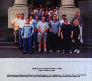
Photograph - Laminated Photograph - Colour, VIOSH: Certificate IV in Occupational Health and Safety; Intake 19, October 2000. (AWU)
Victorian Institute of Occupational Safety and Health (VIOSH) Australia is the Asia-Pacific centre for teaching and research in occupational health and safety (OHS) and is known as one of Australia's leaders in the field. VIOSH has a global reputation for its innovative approach within the field of OHS management. VIOSH had its first intake of students in 1979. At that time the Institution was known as the Ballarat College of Advanced Education. In 1990 it became known as Ballarat University College, then in 1994 as University of Ballarat. It was 2014 that it became Federation University. VIOSH Australia students are safety managers, senior advisors and experienced OHS professionals. They come from all over Australia and industry. Students are taught active research and enquiry; rather than textbook learning and a one-size fits all approach. VIOSH accepts people into the Graduate Diploma of Occupational Hazard Management who have no undergraduate degree - on the basis of extensive work experience and knowledge. Photograph of thirteen students enrolled in Certificate IV in Occupational Health and Safety: Intake 19 - October 2000, (AWU)Colour photograph laminated. Names of students under photographNames of studentsviosh, victorian institute of occupational safety and health, occupational health and safety, certificate iv, october 2000, intake 19, awu, jeff allen, ian barrett, frank bourke, rick caimes, trevor clynick, terry cook, lee cornell, anthony gerrard, peter groves, allan king, terry kitson, elizabeth malseed, peter mckendrick, jason penny, paul reid, raymond rooney, sue sarancic, karen shiels, paul spear, joseph xuereb -
 Federation University Historical Collection
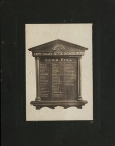
Photograph, Happy Valley State School No.376 Honor Roll, c1920
World War One honor roll of former students of the Happy Valley State School No 376 who enlisted. The original honor roll no longer exists. There is a framed photograph of it in the current Happy Valley School building now used for community events. This honor roll would appear to be made before the end of WW1 as Ernest Alfred Yung died in September 1917 at Ypres. His brother George Alfred Yung returned who was also in the same battle returned to Australia. Honour rolls were also made to encourage more men to enlist. Margaret Young studied at Ballarat West Art School in 1894. This was one of Ballarat's Art schools. In 1907 they merged and became Ballarat Technical Art School (BTAS). Margaret became a teacher and taught for many years at BTAS, specialising in woodcarving. At the end of the First World War, Honour Boards were requested to be made to honour the men who had served. Ballarat was the main provider of these boards. Margaret Young was one of the people responsible for the carvings and specially mentioned for her work by the Caulfield School in Melbourne. On her resignation, Margaret moved to Adelaide. At the past students Reunion Celebrations in 1930, Margaret Young was to be the Guest of Honour. Unfortunately she was unable to attend due to ill health. Sepia photograph of honor roll board for World War One with white background mounted on grey cardboardReverse lhs upper - inked words 'Photo only'; centre - 'Mrs J Garvey, Happy Valley'; rhs upper - two stamps, 1 penny and a half penny franked with Ballarat; pencilled writing 'Mrs Garvey Happy Valleyhappy valley, happy valley state school, honor roll, honour roll, o. brough, e. daniels, g. daniels, philately, j. dial, g. dial, a. gradnor, w. gradnor, g. kiely, a. kerr, w. lowe, l. martinez, h. martinez, j. milburn, c. milburn, a. may, e. morgan, f. opie, a. paterson, n. reid, f. rankin, h. smith, t. thomas, l. thomas, e. yung, a. yung, a. bromley, j. blundell, h. barraclough, j. crommie, g. darling, j. darling, w. w. groves, j. gardiner, a. keys, j. keys, p. kelly, s. kelly, m. morgan, w. montgomery, j. rutherford, r. rutherford, p. smith, w. wishart, h. wark, s. ronald, k.n. mcnamee, p. bennington, sister m.j. thomas, d.l. thomas, w.e. thomas, j.s. gower, f.h. gower, s. gower, s.t.m. gower, happy valley school honor roll, a.a. louden -
 Federation University Historical Collection
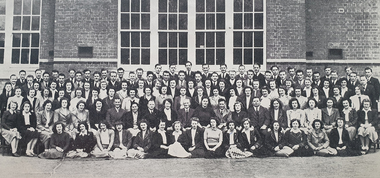
Booklet - Magazine, J.A. Hoskin & Son, Extra Muros: Ballarat Teachers' College Magazine, 1948, 1948
Blue soft covered magazine of the Ballarat Teachers' College. Contents include: * Foreward by Principal Frank Lord "Ich Dien" * Highlights of the College Year * Review of Teacher-Training System Photographic reproductions include: * 1948 staff and students * Magazine Committee * Group Leaders and Student Council * Sports Committee * Social Committee * Exies ^ War Time Schools in Britain * Mallee Lands * Review of Teacher Training Systemnon-fictionm. smale, j. cleland, j. groves, r. lockhart, a. mclachlan, j. coad, c. mansfield, b. thomas, h. frank, r. osborne, m. eichler, n. raggart, r. boatman, g. groutasch, j. forrest, g. golder, m. raisbeck, l. guest, l. morrison, j. pell, d. hunt, p. fuller, m. schier, m. klein, g. denning, w. e. denning, al witney, joyce kennedy, keith mclean, trudy kentish, jack mallett, bill henderson, beth leslie, john o'shannessy, gwen clucas, monica miller, p. hamano, aurita rowland, w.f. lord, c.p. rodoni, helen veitch, galipolli address, tom turner, patrick rodoni, ala sonsee, cornelius barbetti, margaret bradshaw, margaret burke, joan coad, irene ellwood, margaret hanrahan, denis bryans, hans fumberger, frank lord, tom, aurita perry, japanese nobility -
 Phillip Island and District Historical Society Inc.
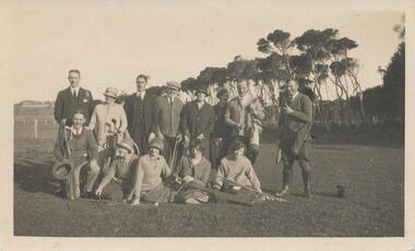
Photograph, Early 1920's
One of 5 photographs donated by Lyn Chambers & Frank Dominick - Wonthaggi Historical Society The following information was sent by a reader of VC for which we are very thankful. The golf course in San Remo was opened in 1922 and was on the land adjacent to Ocean Grove where Griffiths point lodge and Davis Point road now stand. One hole was placed on the flat land on the beach. There were red flags and the cows used to eat them. Black & White photograph of a group of people with their golf clubs. Noted on back of photo "San Remo Golf Links". A question mark re location as it seems too flat. Maybe it was in Cowes?? This has now been updated - see below under "Historical Information" 4/9/2016On back: San Remo Golf Links early 1920'sgolf links san remo, lyn chambers -
Glen Eira Historical Society
Document - CUMBERNAULD
This file contains nine pages about people related to this property: 1/Copy and pasted eight pages taken from Census Records and Trove items. Articles include the death of Thomas Livingstone Cleland during WWI. Various social notes regarding his family up to 1953. There are articles on the W.J. Mathieson family, who also resided there, as well as residing in Benalla. 2/Print from Trove of an article from the 23/11/1934 edition of The North Eastern Ensign (Benalla, Vic) about the wedding anniversary of Mr and Mrs W.J. Mathieson, held at Cumbernauld on 27/10/1934.cumbernauld, thornleigh grange, house names, cleland thomas livingstone, cleland annie, gardeners market, clayton road, ‘hillside’, caulfield, anderson street, cleland sydney, cleland margaret, cleland james, cleland adelaide, cleland robert, cleland bessie adelaide, cleland agnes, cleland lily, cleland alick douglas milkman, cleland aggie, cleland tom h.s. draftsman, cleland kenneth malcolm, cleland ethel, cleland hector, cleland edna may, mathieson w.j., mathieson isabel, burrows f.a. lieut., east st. kilda, hawthorn road, ‘thornleigh grange’, south caulfield progress association, south caulfield junction, caulfield court, jenkins harry, giles alfred, grafton street, elsternwick, dawes john, chloris crescent, st. john’s presbyterian church, mathieson evelyn mary, marks theodore leslie, mathieson kitty, masonic hall, st. george’s road, haverfield frank, haverfield mrs, haverfield robert ross, rynn mary buckley, cyclists, cycling, donald alexander, martin lottie, whitelaw joan, trinity hall, brighton road, gilmore patricia phyllis, brooklyn ave., point nepean road, north road, brighton court, cleland nora, seaview drive, cleland john stuart, mathieson isabella cristina, kalymna grove, mathieson catherine m., tailor, mathieson william james, councillors, social events and activities, births deaths and marriages, anniversaries, world war 1914-18, soldiers -
Glen Eira Historical Society
Ephemera - SHELFORD GIRLS SCHOOL AND KINDERGARTEN
This file contains 2 pamphlets relating to Shelford Girls School: 1/1 pamphlet titled ‘St. Mary’s Church, Glen Eira Road, Caulfield, The First One Hundred Years, 1863-1963’ dated 01/06/1963, containing a brief history of the school on page x. Author unknown. 2/1 pamphlet from the ‘Dedication and Opening of the C. C. Cowling Wing’ at Shelford Girls School, 26/07/1987, containing an order of proceedings for the ceremony. Author unknown.st. mary’s church, glen eira road, caulfield, churches, shelford girls school and kindergarten, hood crescent, dixon emily miss, seymour road, blundell miss, cowling c. c. reverend, allison road, langley h. t. canon, green bishop, thomas a. m. miss, ‘helenslea’, hood judge, st. margaret’s hall, ripley grove, criswick wing, thewlis j. s. miss, thewlis wing, baddams v. t. miss, woods archbishop, cooper e. franklin, cooper wing, v. t. baddams wing, caulfield grammar school, c. c. cowling wing, wilson john bishop, mccaughey jean mrs., pitt marie e. j., welsford smithers esq., cowling nancy mrs., downie peter, gregson tom, frank mas carol miss, parents clubs, clubs and associations, schools, education, openings (events), centenaries -
Glen Eira Historical Society
Document - LECHTE, WILLIAM LUDWIG SAMUEL SEBASTION
3 items about this person: 1/Two twelve page carbon copied documents, purportedly written by William Letchte, son of George, written in c1935/36. He writes of his jobs as a dairyman, cow minder at the age of ten tears. He recollects streets, people, residences, business and general landscape in the area, as he takes you on a tour of the area. 2/Photocopied photo of Katrina Lechte (nee Bolch?) donated by Ian Lechte, 15 Adrian Street, East Bentleigh. 3/Photocopied copy of first pages and cover of William Lechte’s booklet on ‘Caulfield 1869 – 1935 Memories of the Past’, published by the City of Caulfield, 1992. The Society has the full booklet in its book collection (not yet catalogued as of 07/07/2015).grange road, glenhuntly, glen huntly station, alma road, dairies, caulfield park, swamp, queens avenue, station street, cross street, racecourse, heywood j. g., turf club hotel, dandenong road, royal hotel, koornang road, north road, murrumbeena road, mclaurin archibald, crosbie j. w., poath road, newton mr., hooker mr., peck family robert farmer, dairies, ross murray, rosstown, hansen hans, arnott family, peppin family, ormond station, malane family, fraser simon, overtons, shepherds, spring road, mohlers, brighton cemetery, mall kim, market gardeners, long john farmer, fiedler mr., booran road, reservoir, summers mr., maddocks mr., holland mr., caulfield council, glen eira road, harriman benjamin c., kambrook road, bambra road, princess park, marriott john, hawthorn road, brickworks, hyam mr., cottages, jasmine street, sycamore street, paddy o’briens swamp, arnold tom, london tavern hotel, guess john-grocer, topp mr., poath road, pine trees, colonel le marehand, balaclava junction, chemist shop, bell mr., nicholls mr. william h., wine shop, orme mr., pepperorn mr. john, balaclava road, orchards, harvey mr. robert tailor, schubert mr., blew charlie – gardener, philpott mr. richard b., farquhar mr. william farmer, newing t. r., glen eira road, payne john, brockhoft mr., dickson mr. james, snipe t., bevan mr., mckean family john, murray family, francis mr., hart mr., mcdougall james, brady peter, cad, elsternwick station, webb mr., masters mr. samuel, master street, ford mr., anderson mr. joseph gardener, slaney mr., boxhill mr. richard, post office, newsagent, hotham street, service james, bunn mr., sargood mr., orrong road, arnold tom – dairy, officer mr., grimwade mr., alexandra street, oakleigh hall, degraves mr., wilson samuel, ‘manifold’, house names, miller septimus, alma road, knox mr. james gardener, smith mr., coachman, ‘cumloden’, lange mr., holyrood justice mr., cronin mrs. mary, mcgivenys dairy, ‘belle vista’, lloyd c. d., caulfield council, hughes mr., armstrong j. a., tom healey’s market garden, kooyong road, inkerman road, tom roe’s market garden, mcleod captain, daish captain, plumridger mr. frederick, gardeners, tester mr. thomas, kent mr., kent g., fiddes mr., billings mr., semple mr., fosberry mr., howitt or., merrett mr., orchards, hawthorn road, hines mr., ‘rosecraddock’, langdon h. j., ‘crotonhurst’, webb justice mr., renwick s., ‘garrell’, barry mr., drinsdale family, st. mary’s church, sunday school, newing miss, teachers, stephen justice mr., stephen wilberforce, mount l., grimwade’s, ‘grimwade house’, danby’s, spence mr., venables family, mr. moss’ congregational church, barnhill mrs., porter miss, webb’s, ferguson, orange, police stations, kooyong road, pennington mr., health inspectors, engineers, inkley mr., farriers, mckeon mr., ‘sylverly’, dixon mr. edward, turner mr., marriott robert, ‘ravenhurst’, thompson j. j., wott t., architects, perrin mr. francis, tennis courts, royal parade, sayce mr. joseph j. p., ricketson h., ‘glen eira’, mansions, hospitals, turner mr., evans family, stephens miss, registers, mcculloch lady, convalescent homes, prentice street, edward street, strickland, keany pat, brentwood charlie, fordham lewis, hopetoun gardens, higgins mr. joseph f. engineer, railway construction bill, evans mr., beavis mr., twycross family john, medina captain, cowderoy mr. benjamin, murray mr., moore mr., ‘glenfern’, st. georges road, glen huntly road, cedar street, hunt bill – ‘bandy hunt’, jessamine street, alder street, le page’s store, post offices, balaclava junction, stephens frank, solicitors, parkside street, robinson j., ilbery mr. and family, mclennan mrs., victoria street, savings bank, riddell parade, elworthy mr. richard, butchers, shaw mr. william, armstrong mr., guess’ hotel, sycamore street, bagshaw mr., clack joe, wawn alex, sisson family, north road, younger mr., kooyong road, sheridan joseph, anketell family – john, wren john – carpenter, wills mr. peter, attrills arnold, heffernan family, cox peter, ilbery john, hotham street, glen huntly road, page j. w., bakeries, forests, godfrey mr., blacksmiths, thompson j. j., olive street, cedar street, letchte w., tierney richard, alma road, st. kilda east, murray peter, letchte’ cows – grazing, holland grove, eskdale road, lechte katrina, lechte ian, lechte catherine, lechte warren, lechte stuart, lechte elaine -
Glen Eira Historical Society
Document - Ormond Amateur Football Club
... Porter J. R. Nelson W. T. Groves Frank Chisholm L. A. Vinton J. T ...2 articles on Ormond Amateur Football Club, 1933 – 1973: 1/A 12 page document including 3 photocopied photos. Article documents the Premiership coaches for the 1933/34 seasons, a break till 1950 when article then continues to 1973 season. A brief description on the coaches success and mentions successful players who competed in the various team divisions over these years in the document. 2/A pamphlet for season 1935 Ormond Amateur Football Club listing office bearers, patrons, AGM details of business to be discussed, nominations for 1936 and income and expenditure account details.ormond amateur football club, clubs and associations, anthony mick, bentleigh amateur, bols lou, coaches (people), farrell ted, farrell edwin, farrell greg, wood roger, bourne bruce, moran graeme, chisholm andrew, patterson michael, blight bernie, cameron ian m., ferrari brian, kingston jack, foulsham clyde, burdekin e. f., moran graeme f., farrell e. j., graham a., russ jeff, cameron s. m., mcinerney peter j., finlayson brian, grace john, rowse ken, lepage neil, joachim nick, purcell ken, corben bruce f., stock jack, gillespie rob, mcdonald colin, humphries andrew, christie graham, graer david, craig beryl, smith thelma, stock val, johnston j. r., rogers s. w., wood r. j., cameron robert, ladd kevin j., pierce greg, ladd clarrie, meeking john, fitts clive, doble alan, cooper stephen, mclean alan, english graeme, andrew graham, purcell peter, rose mark, borland norm, wood andrew, farrell e. j., logan r. j., morgan peter, faulkner alan, slatter mick, burney cal, stock jack, norris mick/micheal, beecroft barry, crump wayne, humphreys andrew, cameron robert, morris steve, anstee laurie, spence phillip, hand robert, curtis noelene, murphy p. m. peter, foulsham d. a. david, finlayson r. j., roberts r. c., grumpton t. r.-terry, jenkins r. c. ron, mortimer j. i., wood r. j. roger, morgan p. j., graham a. m. alan, curtis r. s., grace j. m., johnston j. r., marshall l. j., logan r. j., jackson d. w., bourne b. k., farrell e. j., sierakowski d. d. peter, dexter p. d., russ j. i., scott d. h., joachim nick, hardham leigh, chapman ray, smith stephen, sterling greg, cramer dean, anstee laurie, barnes ted, barwick john, russell geoff, kozlowski i. a., pearce g. w., roberts r. c., swan g. m., graham a. m., curtis r. s., blight b. f., fitzroy r. m, jackson d. w., farrell e. j., pierce greg, scott david, holman greg, russ steve, mcdonald david, fisher s., o’reilly pat, borland norm, thomas g. t., naylor alan r., lewis m., szylit m., dove s. w., mooney d. j., bevers f. h., gunn e. e., stevens r. a., ellis h., fancett w., grainger v., rermezel y., dawson p., smith r. a., pascoe h., chisholm l. a., jones j. a., juniper p., anderson a. e., ellis r., o’dwyer f., pope a., handcock c., hatton c. h., anthony m., dunbar h., jones w., mckechnie h. j., jennings s., jennings a., porter j. r. dr., hogan j. f., frew g., hassed m. j., ryan rev. father, fethers d. b. dr., hallows bruce, porter j. r., nelson w. t., groves frank, chisholm l. a., vinton j. t., smith w. d., knowling c. h., duus e., evans r. j., smyth l. c., clarke w. j., bishton ja, grant v., tremills f. s., mcfadzean j. d., marley k. j., mckittrick a. e., halkyerd c. s., patience c. e., lynch k., occleshaw f. r., howard r., chapman c. w., jones j. a., evans j. g., ellsworth g., coaches, dunbar h., jones bill, wright bill, mooney mrs., trophies, bishton j. h., manning j., bray h., smyth l., creighton j., wright w., kirchner s., baker n., bevers mrs., gunn mrs., fancett mrs., creighton mrs., stevens mrs., ellis mrs., hatton mrs., mogan mrs., pascoe mrs., frew mrs., phillips mrs., grainger mrs., massed mrs., stillard miss, matt e. g., matt mrs., tremills mrs., cullen l. mrs., parker f. w. mrs., societal events and activities, flags, ormond park trust, sporting clubs, football clubs, football, australian rules football, sports officials, ormond, bentleigh -
Glen Eira Historical Society
Article - MCKINNON
Brief typed history of McKinnon settlement taken from Moorabbin A Pictorial History 1862-1994 by John Cribben. Includes photocopied pages of railway gates, five land estate flyers and an article from the McKinnon Progress, undated.mckinnon, cribben john, crop production, markets, farmers, elster creek, mcmillan archibald, thomas street, centre road, wheatley road, vineyards, south road, ormond, brighton, moorabbin, irish, immigrants, bentleigh, priests, hanrahan pierce, hanrahan johanna, caroll michael, caroll catherine, howes eliza, howes john, howes edward, shanahan denis, shanahan ellen, gould james, gould catherine, howes george, bignell road, jasper road, tucker road, mcguiness family, quinn family, halinan family, malane family, inns, the gardeners arms, mckinnon hotel, bent james, bent thomas, tickets of leave, murray road, were nicholas, sargood family, ripponlea, mansions, elsternwick, st. stephens’ common school, church of england, school houses, evelyn street, st. john’s anglican church, telegraph offices, post offices, state schools, manchester road, north road, nicholls buildings, rivers frank, rivers ray, shops, pridgeon mr., elm grove, sobrin mr., clark misses, greaves bakery, armitage mrs., rout mr., tunnicliffe mrs., lance’s milk bar, johnson’s hardware shop, stiringer mrs., white horrie, robinson’s, mcinnerney’s flower shop, jean darling’s cakes, wyles jim, mckinnon progress association, glen orme avenue, ormond theatre, theatres, lester harry, the plaza, railway crossing, railway gates, wright street, nichols l., builders, pine grove, halls, st. elmo estate, patterson station estate, patterson road, brewer road, purton road, clee hill estate, railway park, hawthorn grove, wattle grove, elm grove, learys estate, manchester road, selkirk avenue, masters estate, lancaster street, moylan street, moorabbin railway crossing -
 Glen Eira Historical Society
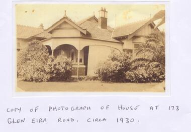
Letter - Maher, Francis Patrick
Correspondence between Mr Frank Maher and Felicitie Ampbell re information about a property at 173 Glen Eira Road, St Kilda East. Included is a copy of Frank Maher’s recollections of people and places around east St Kilda area. Also includes a copy of a photograph of his childhood home c. 1930 and a map of the area around the property where he lived.st kilda east, elsternwick, caulfield, myrtle street, bailey ave, atley grove, glen eira road, hotham street, glenhuntly road, elizabeth street, regent street, balaclava road, mcwhae ave, gordon street, ripponlea mansion, caulfield grammar school, caulfield race course, elsternwick police station, caulfield city hall, city of glen eira city hall, glen eira historical society, holy angels catholic church, st. josephs catholic church, a.r.p. wardens, drill hall, brighton rifles, grocers, sweet shops, terrace houses, tennis courts, saddlers, billiard rooms, horse drawn vehicles, market gardens, motor cycles, fuel merchants, maher frank, tracey martin brian, tracey john edmond, tracey margaret, maher mary eleanor, maher martin john, tracey kathleen, bent thomas, nathan benjamin -
 Glen Eira Historical Society
Book - St. Giles Presbyterian Church, Murrumbeena
This file contains four items about the history of the church: 1/Typed letter dated 17/05/1977 from Mrs. C. Fergusson for the Murrumbeena United Church to accompany Item 2. 2/Four original copies plus a photocopy of ‘St. Giles Presbyterian Church Murrumbeena (An Outline of Sixty-five Years of Progress) 1890-1955’. These include lists of clergy, significant congregational members etc. One of the books is noted ‘Doble’ on the cover, as sent by Allan Doble in Item 3. 3/Handwritten letter dated 15/01/1999 from Allen Doble which accompanied one of the books at Item 2. This letter includes information on Dr Seymour, first Minister at St. Giles. There is also a typed excerpt from the letter. 4/Handwritten note, undated, by person unknown about two Foundation Stones and the Aeneas McDonald Memorial Hall at St. Giles.st. giles presbyterian church, murrumbeena united church, murrumbeena, murrumbeena road, carnegie, rosella street, doble allan, pollock a.l. rev., mclaurin archibald, thomson jean a., ferguson c. mrs., davey. e.t., frith d., riach f.j., doble mrs., memorials, mclaurin jean, ‘frogmore’, ardyne estate, carnegie, rosstown, woornack road, oakleigh road, koornang road, will h. clay nursing home, wahgoo street , innellan road , ardyne street, dunoon street, bute street, toward street, ariadne avenue, burns avenue, thomson avenue, barkley-thomson jean, scott william jones, scott william, scott george, scott john, scott mrs., shearer john, lacey mr., merry mr., hitchcock mr., wilson mr., dawson mr., matters mr., shearer janet bone mcewan, shearer ariadne, shearer elizabeth, mclaurin elizabeth, carpenters, shearer peter, mclaurin archibald, seymour j.a. rev. dr, cullen robert j.s., hamilton james, hethersett grove, sutherland i.b., manses, churches, presbyterian church, clergy, ministers, robertson john kirkland rev., sunday schools, liddelow elsie, seymour elsie, day linda, macdonald aeneas, borland frank, falconer messrs n. and s.a., kelly hugh rev., shearer mary macpherson, mcnabb hugh, william louis r., architects, crabb t.f., murrumbeena presbyterian church, mcleod robert, elmore frank, cayser stella, dowding keith mccallum, howden william b., thompson w.h., lyle n., anderson mr., angus mr., inglis mr., donald w.g., thompson j.g., gilbert w.r. , dickson percy, van nooten j.w., moore r.s.m., wreen w., chambers paris, brown c., lavender e., price n., birtchnell o.e., shearer m., rae w.f., hurdman m., bates clarice, lawrie tom, morris t.w. and son, builders, macdonald elspeth, mckinnon j.s., buntine w.j., kerr w.j., porter a.j., cooper mrs., haddon and henderson, foundation stones, church groups, halls, mclean r.w. rev., macdonald a.e. rev., williams louis r. (architect), crabb t.f. (builder), aeneas macdonald memorial, millar d. right rev. moderator, falcolner n. and s.a. (builders), koornang uniting church -
 Federation University Historical Collection
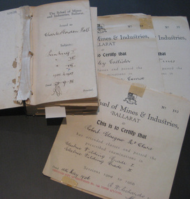
Book - Certificate stub book, School of Mines Ballarat, Ballarat School of Mines Certificate Stubb Book, 1938-1964
This certificate stub book contains the subject certificates of the graduates of the School of Mines and Indutsries, Ballarat, a predecessor of Federation University Australia.This item highlights the subjects studied and graduates of the School of Mines between 1938 to 1964. It also records the change of cursive over that time.This book includes stubs of subject certificates from the School of Mines and Industries, Ballarat. This also contains a number of uncollected certificates. It is a brown hardback book with black binding. Its contents covers certificates between 1938 to 1964. Names of recipients include: Charles Holt, Henry Elford, Irvin Singleton, J. H. Hughes, John Morcom, Alfred Amor, John Wastell, John Rudwick, Jared Hines, Harry Allan, L. F. J. Hillman, Arthur Davies, Letitia Stanley, Victor Wright,Raymond Ball, Mary O'Callaghan, Ethna Burke, Alec Foyster, James Duggan, Leonard Auchettl, Reeves Collins, James Patterson, Stanley Douglas Webb, Oswald Lyle, Marvis Orr, Eric Roberts, Jack Clennell, A. R. Millar, Heith Smyth, Walter Hines, Harold Leslie, Joseph Fisher, Geoffry Burns, Alick Dait, George Hill, Raymond Wines, Robert Manson, Albert O'Neill, Thomas Green, William Stargatt, William Harrison, Reginald Allen, Albert Wilson, Allan Curtis, Arthur Donald, John Wynn, Sydney Robinson, John Blackic, Percy Elsdon, Hubert Jenkins, Kingsley Callister, Douglas Hall, Norman Lawson, Winfield Tonkin, Artuhur Williams, Allan Curtis, Ernest, Billinge, John Daelon, Harold Bunting, Stanley Wilton, Robert Sugden, Heith Foster, Winsome Stevens, Herbert Stanbridge, Robert Pittard, Henry Brew, Ernest Berriman, Carlyle West-Onley, William Blackic, Lorna Dunstan, Cedric Pike, Stanley Jephson, Hugh Hendrick, Joseph Fisher, Ernest Grove, Ronald Fisher, Heith Halsall, Henry Harris, Maxwell Silvey, Stanley Trengove, Donald Trescowthick, Harold Tolliday, Russell Lucas, John Boyd, John Keys, Stanley Betteridge, Ernest Betteridge, Michael Ross, Robert Stewart, Joseph Beasley, William Beasley, Ray Deveson, George Hennessy, Charles Matthews, Maxwell Silvey, Ian Creek, Geoffrey Moorhouse, Hector Tonks, John Donald, Hugh Hendrick, Stanley Jephson, Ian McIntosh, Robert Nice, Ralph Scott, Walter Martin, Grant Coutts, Lindsay Hannah, John Tainsh, Hubert Robinson, John Donald, George Beaton, Heather Harris, Brian McCarthy, Samuel Perry, Valentine Pascoe, Philip McLean, Geoffrey Hewish, Hubert Robinson, John Borch, Frederick Gale, Ian Grundell, Albert Perry, Frank Hutchinson, Horace Shuttleworth, Kenneth Mason, David Hatt, Malcom Foster, George Jones, Graham McKinnon, Ronald Newton, John Betts, Leonard Wade, Robert McClure, David Beaumont, Leslie Powell, Samuel Perry, Donald Treweek, Edgar McArthur, Russell Fraser, Edgar McArthur Bartrop, Clive Carmichael, Leslie Fuhrmeister, Lindsay Coon, Zigurds Plavina, Victor Gingell, Rupert McKenna, Graham McKinnon, David Fairley, Johannes Meennen, Ronald Murphy, Johannes Naus, John McConville, Graham Melonie, William Cutter, Thomas Chalkley, Kenneth Morton, Stanley Shears, Robert Auld, Donald Campbell, John Cofield, Brian Whykes, William Milford, Noel Richards, Stewart Jacobs, James Robertson, Clement Rose, Eric Brown, Allan Raworth, Ernest Salter, Neville Cartledge, Peter Stacey, Robert McClure, Antonius Goossens, Rodney Cartledge, Rodney Hayes, Bevan Grigsby, James Robertson, Neil Stephens, John Riddle, Andreas Aaus, Bruce Fletcher, Keith Pedler, Allen Flavell, Robert Cartledge, Ronald Shaw, Kenneth Hibberd, William Lockland, Percival Bilney and Petrus Damen. Uncollected certificates for James Patterson, Robert Sugden, Ernest Berriman, Stanley Jephson, Henry Harris, Maxwell Silvey, Joseph Beasley, Charles Matthews, Maxwell Silvey, Ian Creek, Geoffrey Hewish, Robert McClure, Kingsley Callister, Winfield Tonkin, Raymond Wines, Oswald Wilde and Kenneth Mason are included within. The subjects covered include: Printing, mining, geology, metallurgy, mining geology, mine surveying, mechanics applied to mining, electric welding, machine shop practice, algebra, trigonometry, mechanics and heat, applied mechanics, heat treatment, graphics, oxywelding, engineering drawing, blacksmithing, shorthand theory advanced, shorthand speed, commercial English, intermediate English, plain dressmaking, dressmaking advanced, electric wiring, physics, electric technology, carpentry, machine shop, plumbing, trade science, carpentry and joinery, building construction, heat treatment, wiring, oxyacetylene welding, foremanship, turning and fitting, electric wiring, arithmetic, social studies, commercial correspondence, office routine, bookkeeping, typewriting, shorthand, electric refrigerator servicing, refrigeration, radio mechanics, trade maths, sheetmetal, wool sorting, motor mechanics, human relations in management and industrial supervision. Many of the stubbs are signed by principal Dick Richards. Each certificate is signed by the current principal of the School of Mines and Industries, Ballarat, and a number have also been signed by the students.school of mines, school of mines andindustries, certificate, richard w. richards, horace william shuttleworth, dick richards, charles holt, henry elford, irvin singleton, j. h. hughes, john morcom, alfred amor, john wastell, john rudwick, jared hines, harry allan, l. f. j. hillman, arthur davies, letitia stanley, victor wright, raymond ball, mary o'callaghan, ethna burke, alec foyster, james duggan, leonard auchettl, reeves collins, james patterson, stanley douglas webb, oswald lyle, marvis orr, eric roberts, jack clennell, a. r. millar, heith smyth, walter hines, harold leslie, joseph fisher, geoffry burns, alick dait, george hill, raymond wines, robert manson, albert o'neill, thomas green, william stargatt, william harrison, reginald allen, albert wilson, allan curtis, arthur donald, john wynn, sydney robinson, john blackic, percy elsdon, hubert jenkins, kingsley callister, douglas hall, norman lawson, winfield tonkin, artuhur williams, allan curtis, ernest billinge, john daelon, harold bunting, stanley wilton, robert sugden, winsome stevens, herbert stanbridge, robert pittard, henry bre, ernest berriman, carlyle west-onley, william blackic, lorna dunstan, cedric pike, stanley jephson, hugh hendrick, joseph fisher, ernest grove, ronald fisher, heith halsall, henry harris, maxwell silvey, stanley trengove, donald trescowthick, harold tolliday, russell lucas, john boyd, john keys, stanley betteridge, ernest betteridge, michael ross, robert stewart, joseph beasley, william beasley, ray deveson, george hennessy, charles matthews, maxwell silvey, ian creek, geoffrey moorhouse, hector tonks, john donald, hugh hendrick, stanley jephson, ian mcintosh, robert nice, ralph scott, walter martin, grant coutts, lindsay hannah, john tainsh, hubert robinson, john donald, george beaton, heather harris, brian mccarthy, samuel perry, valentine pascoe, philip mclean, geoffrey hewish, hubert robinson, john borch, frederick gale, ian grundell, albert perry, frank hutchinson, horace shuttleworth, kenneth mason, david hatt, malcom foster, george jones, graham mckinnon, ronald newton, john betts, leonard wade, robert mcclure, david beaumont, leslie powell, samuel perry, donald treweek, edgar mcarthur, russell fraser, edgar mcarthur bartrop, clive carmichael, leslie fuhrmeister, lindsay coon, zigurds plavina, zig plavina, victor gingell, rupert mckenna, graham mckinnon, david fairley, johannes meennen, ronald murphy, johannes naus, john mcconville, graham melonie, william cutter, thomas chalkley, kenneth morton, stanley shears, robert auld, donald campbell, john cofield, brian whykes, william milford, noel richards, stewart jacobs, james robertson, clement rose, eric brown, allan raworth, ernest salter, neville cartledge, peter stacey, robert mcclure, antonius goossens, rodney cartledge, rodney hayes, bevan grigsby, james robertson, neil stephens, john riddle, andreas aaus, bruce fletcher, keith pedler, allen flavell, robert cartledge, ronald shaw, kenneth hibberd, william lockland, percival bilney, petrus damen, james patterson, robert sugden, ernest berriman, stanley jephson, henry harris, maxwell silvey, joseph beasley, charles matthews, maxwell silvey, ian creek, geoffrey hewish, robert mcclure, kingsley callister, winfield tonkin, raymond wines, oswald wilde, kenneth mason, trades -
 Federation University Historical Collection
Booklet - Magazine, Extra Muros: Ballarat Teachers' College Magazine, 1948, 1948
Blue soft covered magazine of the Ballarat Teachers' College. Contents include: * Foreward by Principal Frank Lord "Ich Dien" * Highlights of the College Year * Review of Teacher-Training System Photographic reproductions include: * 1948 staff and students * Magazine Committee * Group Leaders and Student Council * Sports Committee * Social Committee * Exiesnon-fictionm. smale, j. cleland, j. groves, r. lockhart, a. mclachlan, j. coad, c. mansfield, b. thomas, h. frank, r. osborne, m. eichler, n. raggart, r. boatman, g. groutasch, j. forrest, g. golder, m. raisbeck, l. guest, l. morrison, j. pell, d. hunt, p. fuller, m. schier, m. klein, g. denning, w. e. denning, al witney, joyce kennedy, keith mclean, trudy kentish, jack mallett, bill henderson, beth leslie, john o'shannessy, gwen clucas, monica miller, p. hamano, aurita rowland, w.f. lord, c.p. rodoni, helen veitch, galipolli address, tom turner, patrick rodoni, ala sonsee, cornelius barbetti, margaret bradshaw, margaret burke, joan coad, irene ellwood, margaret hanrahan, denis bryans, hans fumberger, frank lord, tom -
 Federation University Historical Collection
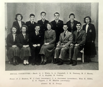
Magazine, Extra Muros: Ballarat Teachers' College Magazine, 1949, 1948
During 1948 Principal Frank Lord, a Gallipoli veteran, gave an inspiring address reminding students of the great sacrifice made by the Anzacs at Gallipoli. "These men set a high standard which has been followed by men of the second World War. We as teachers can help set standards amongst the children we are privileged to teach, and this we have an important task to do. We also must pay particular care to children of the men who fought and died in the two Great Wars through which our country has passed."Blue soft covered magazine of the Ballarat Teachers' College. Contents include: * Foreword by Principal Frank Lord "A teacher affects eternity, he can never tell where his influence stops" Photographic reproductions include: * 1949 staff and students * Hostels * Clubs * Sports * Lapses into Literature Images include: * S.R.C. and Group Leaders * Social Committee * Sports Committee * Magazine Committee * Hockey * Basketball * Football Inside front cover "Monica Miller"ballarat teachers' college, frank lord, david j. collins, john h. gervasoni, maureen godfrey, margaret collins, peter fryar, wal wall, j.w. blackie, monical miller, e.n. tippett, g.j. white, d.h. evans, p.j. hudson, m.l. collins, m. godfrey, gallipoli, physical education, i. ellwood, m. smale, j. cleland, j. groves, r. lockhart, a. mclachlan, turner, j. coad, lord, c. mansfield, john hogan gervasoni -
Tatura Irrigation & Wartime Camps Museum
Certificate of Title, Subdivisions, 1879 and 1930
Title Deeds for property in Tatura2 certificates of title showing subdivisions made over several years. Vol. 5655:Folio 1130935 dated 16/5/1930 and Vol.1182: Folio 236330 dated 23/12/1869. Lease between Thomas Hogan and W F Bazeley dated 7th July 1911 for land in Hogan Street known as Slaughter Yard Paddock .Also lease dated 1911. In buff coloured legal envelope with number "2678" and "Hogan - Thomas" written in red on outside.tatura, relationship folders, certificate of title, lease, thomas hogan, john hogan, john james hanlon, edward glover, arthur burke, james brady, andrew collie, jean hunter, sydney embling, john maher, arthur goyen, patrick o'toole, philipe dove, george wildon, edwin harden, cuthbert corke, lee chung, hugh barnes, george manning, francis williams, john fawkner, michael walshe, alexander ferguson, rose gullett, john gibb, william taylor, richard casey, anthony grover, arthur grover, charles brady, elizabeth davey, frank williams, honora culkin, alexander park, stephen reville, richard carr, charles grover, henry mccarthy, james bruce, edward hanley, chew yen, ah poy, loo way, ah dick, charles mitchell, lionel martin, douglas forsyth, catherine wilson, mabel heath, patrick mcnamara, micheal cussen, james wilson, bazeley, documents, legal -
Whitehorse Historical Society Inc.
Legal record - Land Title, Certificate of Title, 1932
A letter to Mr A. Roy Charlesworth, valuer, Shire of Blackburn and Mitcham, accompanying four copies of certificates of title.A letter to Mr A. Roy Charlesworth, valuer, Shire of Blackburn and Mitcham, accompanying four copies of certificates of title.A letter to Mr A. Roy Charlesworth, valuer, Shire of Blackburn and Mitcham, accompanying four copies of certificates of title.shire of blackburn and mitcham, orchard grove, blackburn south, simla street, mitcham, orient avenue, mitcham, land titles, charlesworth, albert roy, canterbury road, blackburn south, halls parade, mitcham, furness, albert george, kemp, frank, lemke, gustav robert, huffey, emily may -
Whitehorse Historical Society Inc.
Document, Certificate of Title, 1914 - 1928, 1933
Certificate of Title.Certificate of Title, Frank Wesley Day. Lot 14 Subdiv. 6280 Crown portion 84 Blackburn 1928. Certificate of Title. Frank Wesley day Lots 15,22 & 23 as above. Vol 3817 fol 763269 1914. Certificate of Title. Frank Wesley Day Lot 21 as above. Vol 4259 fol 851779. Certificate of Title Charles Morgan Rosser Vol 5262 Fol 1052323. 1927 Certificate of Title. Beatrice May Ward Oakley. Lot 17 Subdiv 6280 Portion 84 Vol 4132 fol 826293. 1918 Certificate of Title, Beatrice May Ferguson, Lots 18, 19 & 20 Subdiv 6280 Vol 3856, fol 771029. 1914. Also correspondence re enforcement of charge 1933.Certificate of Title.land titles, shire of nunawading, shire of blackburn and mitcham, day, frank wesley, rosser, charles morgan, oakley, beatrice may ward, ferguson, beatrice may, the avenue, blackburn, laurel grove, blackburn, fuschia street, blackburn -
Whitehorse Historical Society Inc.
Pamphlet, Hill 60 Estate, 1/02/1929 12:00:00 AM
... Mitcham melbourne Donated by son of Frank Fisher who named Menin ...Auctioneers brochure for Hill 60 estate,Auctioneers brochure for Hill 60 estate, Tunstall, 37 sites, subdivisional auction sale, 3.30 pm Saturday 23 February 1929. Agent: Frank Fisher & CoAuctioneers brochure for Hill 60 estate, hill 60 estate, tunstall, frank fisher & co, forest hill, menin road, nunawading, mount pleasant road, nunawading, shady grove, nunawading, fisher, frank -
Whitehorse Historical Society Inc.
Pamphlet, Hill 60 Estate, 1/04/1957 12:00:00 AM
Auctioneer's brochure for Hill 60 Estate, Forest Hill.Auctioneer's brochure for Hill 60 Estate, Forest Hill. 64 sites for auction 2.30 pm Saturday 13 April 1957. Agent Frank Fisher & Co.Auctioneer's brochure for Hill 60 Estate, Forest Hill. forest hill, hill 60 estate, forest hill, frank fisher & co, fisher, frank, menin road, nunawading, andrew street, nunawading, fisher street, nunawading, will street, nunawading, jocelyn court, nunawading, shady grove, nunawading -
Whitehorse Historical Society Inc.
Newspaper - Article, Isn't it wonderful, 19/04/1967
... . Dewar S.G. Woodhouse Grove Homestead Bamford Frank Aspinall ...Daughter of pioneer, Mrs Helen Amelia Rowley celebrated 100th birthday and is presented with a letter of congratulations by mayor, Cr E.O Lundgren, town clerk, Mr A.N. Wallis and Cr S.G. Dewar. Photos of Mrs Rowley and homestead in Woodhouse Grove where she was born in 1867.rowley, helen amelia, lundgren, e.o., wallis, a.n., dewar, s.g., woodhouse grove homestead, bamford, frank, aspinall, rupert, aspinall, myrtle, furneaux, connie, aspinall, alice, furneaux, lena -
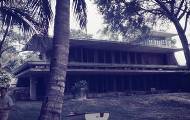 Robin Boyd Foundation
Slide, Robin Boyd, 1956-1957
Robin Boyd developed a close friendship with the founder of the Bauhaus in Weimar Germany, Walter Gropius, who had moved to the USA in the 1930s. Through this connection, Boyd was invited to be the Massachusetts Institute of Technology (MIT) Bemis Professor at the School in the North American academic year 1956-7. Robin and Patricia Boyd, with their youngest daughter Suzy, were based in Cambridge, Massachusetts for the year. Boyd gave some lectures at MIT and he was also invited to give lectures at many other universities, allowing him to travel widely within the USA, especially on the East Coast. This gave him the opportunity to meet architects like Frank Lloyd Wright, Eero Saarinen, Paul Rudolph and many others, and visit the offices of Skidmore, Owings and Merrill, and places like Taliesin and the General Motors Technical Center Detroit. On the way home, the Boyds visited London, Berlin, Paris and Le Corbusier’s Ronchamp Chapel in France.Colour slide in a mount. Parker House, Coconut Grove, Miami, Florida, USA, 1954. (Architect: Alfred Browning Parker.)Made in USA / Patentedmit bemis professorship, mit, robin boyd, slide -
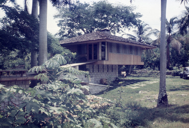 Robin Boyd Foundation
Slide, Robin Boyd, 1956-1957
Robin Boyd developed a close friendship with the founder of the Bauhaus in Weimar Germany, Walter Gropius, who had moved to the USA in the 1930s. Through this connection, Boyd was invited to be the Massachusetts Institute of Technology (MIT) Bemis Professor at the School in the North American academic year 1956-7. Robin and Patricia Boyd, with their youngest daughter Suzy, were based in Cambridge, Massachusetts for the year. Boyd gave some lectures at MIT and he was also invited to give lectures at many other universities, allowing him to travel widely within the USA, especially on the East Coast. This gave him the opportunity to meet architects like Frank Lloyd Wright, Eero Saarinen, Paul Rudolph and many others, and visit the offices of Skidmore, Owings and Merrill, and places like Taliesin and the General Motors Technical Center Detroit. On the way home, the Boyds visited London, Berlin, Paris and Le Corbusier’s Ronchamp Chapel in France.Colour slide in a mount. Ewing Residence (1957) Coconut Grove, Florida, USA. (Architect: Alfred Browning Parker.)Made in USA / Patentedmit bemis professorship, mit, robin boyd, slide