Showing 152 items matching "additional land"
-
 Eltham District Historical Society Inc
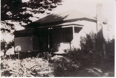
Photograph - Digital Photograph, Jim Connor, Edendale Farm Homestead, 11 December 2014
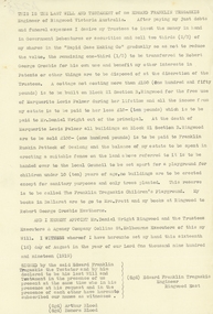
Edendale Farm is Nillumbik Shire Council's environment centre situated in Gastons Road, Eltham between the railway and the Diamond Creek. The homestead on the property was built in 1896 and is of historical significance, being the subject of a Heritage Overlay under the Nillumbik Planning Scheme. The Edendale property was originally part of an extensive land purchase in 1852 from the Crown by pioneer Eltham farmer Henry Stooke. He initially purchased 51 acres and later expanded his holdings by purchasing another three adjacent Crown allotments extending northerly from Josiah Holloway's Little Eltham subdivision. Despite clearing the land, Stooke did not build on this property, choosing to live on his property "Rosehill" at Lower Plenty. In 1896 Thomas Cool, Club Manager of the Victoria Coffee Palace in Melbourne purchased 7 acres of the original Stooke land and built the house now known as Edendale. Cool did not farm the land, instead using it as a gentleman’s residence, retiring to Eltham at weekends. In 1918 he purchased an additional 7 acres but in 1919 he sold the property. Later owners included J.W. Cox, the Gaston family and D. Mummery. In the 1980s the Eltham Shire Council purchased the site for use as a Council depot, but this use did not proceed. Subsequently, it was used as the Council pound. The Edendale Farm Pet Education and Retention Centre was established in the summer of 1988/1989 and was set up to replace the existing dog kennels with a high standard pet retention centre. The design style of the building was established to compliment the features of the existing house. It was equipped with 10 retention pens, a veterinary room and a pet education area where school children and other interested parties learnt about pet care procedures. It was later developed into a community farm and was run by an advisory committee and in 2000 it became an Environment Centre. In early 2006 an advisory committee was established for the development of a master plan for future development at Edendale Farm. The committee included Russell Yeoman, a former long-time shire planner and founding member of the Eltham District Historical Society. At the time of filming the Master Plan and future for Edendale was about continuing to develop Edendale as a centre of environment learning and looking at expanding displays and school program, running a lot more of life-long learning and workshops around sustainable living.jim connor collection, edendale community farm, edendale farm, eltham, gastons road -
 Glen Eira Historical Society
Plan - Jasper Road, 236-246, McKinnon
Three items relating to the valuation of this property: 1/A typed copy of a three page valuation of 236-246 Jasper Road, McKinnon, by valuator W V Scott for Atlantic Union Oil Co Pty Ltd, dated 11/08/1961. Accompanying this are a hand-drawn plan of the property and handwritten working notes for the valuation. 2/One additional page of correspondence from W V Scott to Atlantic Union Oil, dated 11/08/1961, informing them that the occupier of the property, L A Atkinson’s Garage and Panel Beating Works, was aware of the valuation taking place. 3/Field Purchase Order for the valuation of the property from Atlantic Union Oil Company Pty. Limited dated 19/07/1961.jasper road, mckinnon road, mckinnon, atkinson l.a, webb d mr, l.a atkinson’s garage and panel beating works, moorabbin council, atkinson mr, atlantic oil co pty ltd, morris g h, scott w v, motor vehicle repair shops, garages, petrol stations, factories, land use, land values, anderson's garage & panel beating works -
Glen Eira Historical Society
Letter - Masonic Hall St Georges Rd, 17, Elsternwick
A typed valuation by W.V Scott dated 4/08/1964 of the Masonic Hall at 17-19 St Georges Road, Elsternwick on behalf of EJ Maskell. It includes land measurements, details of the rooms and their features as well as the final valuation and additional note as to the cost of the valuation. Handwritten notes of the valuer included.masonic hall, st georges road, scott wv, maskell fj, glenhuntly road, churches, baptist church, caulfield council, land values, property values, elsternwick, halls -
 Eltham District Historical Society Inc
Photograph, Tess Justine (Nillumbik Shire Council), Murray's Bridge over the Diamond Creek, Eltham North, 19 Feb 2022
Murray's Bridge over the Diamond Creek on the Diamond Creek Trail just prior to demolition and replacement with a new steel bridge. Heritage advice obtained by Nillumbik Shire Council, following a suggestion by the Eltham District Historical Society (EDHS), is that the original bridge appears to have been a simplified version of the Country Roads Board’s (CRB) standard timber bridge design of the early-to-mid 1920s. In c1990 Murray’s bridge was renovated with three recycled steel girders as part of a bike/pedestrian path in the reserve. During these alterations many parts of the bridge were removed, and some were replaced. Heritage advice indicates the condition of Murray’s bridge is poor. The remaining original parts are all in poor condition, with severe weathering, splitting and rot, especially to the stringers retained on the bridge. Heritage advice is that Murray’s Bridge does not have sufficient significance in the cultural history of the Nillumbik area to warrant inclusion in the Nillumbik Shire Heritage Overlay and also does not have sufficient significance as a rare survivor to warrant inclusion in the Nillumbik Shire Heritage Overlay. There are no indications in the historical record that this site was individually important to the cultural history of this area. EDHS is comfortable with the heritage advice provided to Council and has worked closely on this project with Council. EDHS has suggested some of the removed timbers be used in the vicinity of the bridge for landscaping and possibly seating, so as to retain these remnants close to the site of the original bridge, which is the last old timber bridge along the lower reaches of the Diamond Creek. Mary (Sweeney) Murray and John Wright Murray selected 80 acres, Lot C Section 16 and Lot 5 Section 17 Parish of Nillumbik, under an occupation license in 1866. John died in 1867 and freehold was granted to his son John in 1873. The farm was known as ‘Laurel Hill’. John Junior was an Eltham Shire councillor and sometime president from 1887 up until 1897. He added Lot A Section 16 to the farm in ca1888. John and his younger brother James arranged to rent/purchase Lot B Section 17, across Diamond Creek to the west, in ca1900. It appears that John and James farmed separately for a few years, with a new homestead built for James ad family on the high point of Lot B Section 17 in ca1910. John sold off Lot 5 Section 17 in 1912. When John died in 1912 James took over the land on both sides of the Diamond Creek. The old homestead on the west side of the Creek disappeared. A farm bridge over Diamond Creek from this period may have been located close to the northern boundary of the farm. John Langlands, owner of the farm known as ‘Ihurst’ on the west side of Diamond Creek to the south of the Murray’s land, died in 1907. In 1909 his land was then subdivided into 100 lots to become the ‘Glen Park Estate’. Other similar subdivisions of nineteenth century farms around Eltham in this period included the ‘Franktonia (or Beard’s) Estate’ to the northeast and ‘Bonsack’s Estate’ between Eltham and Greensborough. Soon after the opening of the railway extension line from Eltham to Hurstbridge in 1912, Glen Park and nearby residents including James Murray agitated for a railway station or siding to be located half-way between Eltham and Hurstbridge, so that the Glen Park residents who used the railway daily did not have to walk into the Eltham or Hurstbridge stations. Some believed Coleman’s Corner (opposite Edendale Farm) was an appropriate spot for the platform. James Murray was among those who thought the railway should be located on his land, closer to half-way between Eltham and Hurstbridge stations. The Railways Commissioners warned that the locals would have to fund these works themselves. The Glen Park Estate residents initially had difficulty accessing Eltham by road, with only an old low-level bridge over Diamond Creek at the south end of their estate. A new timber trestle bridge across the creek, now on Wattletree Road, was opened in 1915. Road access to the north was gained in 1927 when the new Murray’s Road, which crossed the Murray’s land, was built. Residents continued to agitate for a Glen Park station. By 1926 the Railways Commissioners’ preferred site was on the Murray’s land. They arranged an estimate of cost of a full-length platform. The estimate was too much for the locals, who in 1928 argued unsuccessfully for a shorter and hence cheaper platform. By 1929 Murray had agreed to donate the land, but the locals would still have to fund the works. Murray decided, unilaterally it would appear, to commence work on a timber trestle road bridge over Diamond Creek to link the new Murray Road to the proposed station. Late in 1929 he stopped work on the bridge, for reasons unknown, but started work again and completed the bridge in 1931. There is no further newspaper evidence of the campaign for the Glen Park station until 1939, when Murray and another local, Mr Maxwell, met the Railways Commissioner. The Glen Park locale now included 45 homes on the west side of the creek and 20 on the Eltham side. Most of the residents used the train every day. The Commissioner remained adamant that only a full-length platform could be built for safety reasons. It appears the campaign dissolved at this point. The increasing move to cars may have had an impact. There is no evidence of Murray’s bridge ever being connected to Murray’s Road, or of it having wide use for any purpose by locals. James Murray died in 1947 and the farm was taken over by his son James (Jim). Jim started to sell off parts of the farm in the 1980s, retaining a few acres around the ca1910 homestead and building a new house there. Recreation reserves were established along the creek. In ca1990 Murray’s bridge was renovated with steel girders as part of a bike/pedestrian path in the reserve. The old farmhouse was demolished in ca2014. * * * A theory posted on local community Facebook groups was that the bridge was built in the 1860s and was built to be more robust than was necessary for the movement of cows from one side of the creek to the other. It was suggested the robustness was necessary to support the weight of gold ore being transferred from a mine on Murray’s land to a railway siding near Murrays Bridge (presumably for transfer and processing at Diamond Creek). Perhaps this may have been one of the motivators for Murray, who really knows? Knowing when mining operations ceased on his land and how that fits the overall timeline would be useful but at the time the bridge was built, local gold production was minimal at best. The known facts are: • The railway line came to Eltham in 1902. • The extension of the railway from Eltham to Hurstbridge was constructed in 1912 so no railway line even existed through Murray's property until 1912 and the Victorian Railways maps at the time show no such siding on Murray’s property. • In 1923 a new company was formed in anticipation of the old Diamond Creek Gold Mine being re-opened. The mine had been previously closed and flooded. It was noted in the press at the time that the mine was within a mile of the railway. Nothing really came of this. • Construction of Murrays Bridge was commenced by James Murray in early 1929 in anticipation of a proposed flag station being nominated on his land, but work ceased shortly afterwards. The proposed flag station was commonly referred to as Glen Park as the residents of the Glen Park Estate wanted Option 1, located near them with the platform adjacent to Colemans corner. This was probably never going to fly as it was virtually in eyesight of Eltham station. Allandale Road was the third option, but the Commissioners' preferred option was No. 2 - on Murray's property. • The Railway Commissioners were not going to finance any such station and the works had to be funded by private landowners and residents, hence Murray investing in this himself. • Murray recommenced work two years later and finished his bridge in 1931 but unfortunately for him, the proposed flag station never eventuated. The bluestone siding you reference may well have been built by Murray as part of the proposed station platform. • Up until then, apart from the Main Road bridge, which was washed away in 1924, virtually all local crossings over the Diamond Creek were low lying bridges – Kaylocks Bridge at Brougham Street, Diamond Street bridge, Glen Park Road bridge. It is expected that Murray also had a low-lying bridge to connect his land either side of the creek. These were all washed away or severely damaged multiple times in the 1920s. Lessons were learnt, and Murrays Bridge appears to have been built in accordance with Country Road Board standards of the time. Flood damage was ongoing, and even more recently constructed raised bridges kept getting washed away, e.g., the new Wattle Tree Road bridge in 1958 just months after completion. Murray’s bridge was reinforced with steel some 30 years ago presumably to provide additional floodwater resistance, given the history of bridges disappearing in floodwaters. • In March 1932 it was reported in the Advertiser that there were still some prospectors operating around Eltham North who apart from further scarring the face of the earth over the previous two years had gained significant experience but little gold - hardly a driving factor for constructing a dedicated railway siding and bridge to transfer gold ore. It is far more probable that James Murray was hoping to have the railway station located on his property and invested his money by building the bridge to lead to it as well as a station platform. Had the station eventuated, it may well have driven up the value of his land for subdivision and new housing estates like the Glen Park Estate. That did not eventuate. Whilst the bridge was indeed old (90 years), the core structure being completed in 1931, it had been modified substantially from original and hence had no significant historic value – i.e., it was not a representative example of its type, construction, and age. Given that the bridge was not worthy of saving, the Eltham District Historical Society with Council’s support, and the Eltham Woodworkers group endeavoured to see what suitable sized timbers were salvageable to fabricate a commemorative seat. Unfortunately, the experts at the Woodworkers group were unable to salvage any suitable length/width timbers to fabricate the seat due to the presence of rot. Last remaining wooden trestle bridge on the Diamond Creek Trail just prior to demolition and replacementBorn digital image (27)diamond creek (creek), diamond creek trail, murrays bridge, ‘laurel hill’, john wright murray, mary (sweeney) murra, john murray jnr, james murray, john langlands, ‘ihurst’, ‘glen park estate’, beard's estate, franktonia, bonsack's estate, glen park estate, glen park railway station -
 Eltham District Historical Society Inc
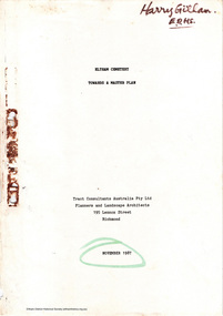
Document - Report, Tract Consultants Australia Pty Ltd, Eltham Cemetery: Towards a Master Plan, Nov 1987
BACKGROUND The Eltham Cemetery is of historic significance to the Eltham area. The Trust was established in 1858 and has administered and maintained the cemetery from that date right up to the present. Among the more noteworthy graves is that of Sir William Irvine, a former State Premier and Chief Justice of Victoria. Eltham Cemetery is surrounded on three sides by urban development. Montsalvat Artists Colony adjoins the remaining (eastern) side. A Joint Select Committee of Parliament called the “Mortuary Industry and Cemeteries Administration Committee" (MICA) enquired into the land requirements at the Eltham Cemetery in 1986. The MICA recommendations contained in its 1986 report are included in the Appendices attached to this report. Although the recommendations have not been adopted by the Government it is interesting to note that the MICA report recommended the use of the bulk of the land for cemetery purpose. In June of 1987, the Cemetery Trust was expanded to include additional members from the Eltham Community by the Minister for Health. At the same time, he instructed the Trust to resolve the land requirement issues. As a result of this Ministerial direction, Tract Consultants has been instructed by the Eltham Cemetery Trust to prepare a report addressing the issues raised in the Minister's letter (see Appendix 1) to the Trust. Principally, the study will examine options available for development of the Cemetery. These options will explore possible boundaries, cemetery design, vegetation, the overall environment, landscaping and financial planning for the Cemetery operations. Appendix 2 details the Cemetery Trusts Terms of Reference for the Study. Before commencing the study in detail, additional basic information was sought; viz: a) sub-soil and rock analysis; and b) feature survey by a Licensed Surveyor. The results from both exercises are included as appendices to this report. Section three includes a summary of the findings along with other analytical results. Also: Eltham Cemetery - planning bewteen 1859 to 1860; research by Alan Sheehan April 2015, collated by Harry Gilham, EDHS, April 2016 (2 pages) PROV Guide 5: Cemetery Records (8 pages), printed 7 May 2014Development of Eltham Cemeteryeltham cemetery trust, master plan, mica, montsalvat, mortuary industry and cemeteries administration committee, tract consultants -
 Kiewa Valley Historical Society
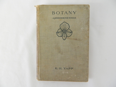
Book - Reference Botany, Botany - A Junior Book For Schools, 1927
This book was a highly regarded reference book for students in primary and lower secondary schools within Victoria from the late 1800s to the mid 1900s. The book provided students with the fundamental knowledge of botany for the era in which it was produced. As this book was targeting a junior schooling level (basic), it could cover a greater and extended reader population. Teaching institutions could, because of its straight forward, basic written information, retain this book's circulation for a greater length of time, thereby optimising the return against the greater initial costs of importing it from England.This book was produced in a time where learning was at a relatively slower pace (due to a smaller source and supply of material). The availability of a large range of cheap reference books such as that offered from 1971 on wards via the internet "Project Guttenberg" in the form of electronic books, has dramatically provided a larger source of reference material. The significance of this book on botany, is that it was highly effective for the era in which it was produced and in particular the students at a rural based school. Being in a rural area students were able to identify local vegetation to the various life cycles of plants presented in this mainly United Kingdom/European referenced book. The students in the Kiewa Valley and attending a rural school, where in a position to study all the fundamental teaching that this book encompassed. This in one way provided students in the valley a slightly better appreciation between book and real life (on the land, in the field and by the river). Later publications of this book had additional Australian references in them.This hard covered book(cloth strengthened) is faded(aged) beige in colour and consists of 204 pages. It is printed in English (black print) on both sides and contains illustrations of both free hand sketches and photographs of plants, both foliage and roots systems. The book is arranged in three sections: three pages of preface, two of contents (28 chapters). The last four pages contain the appendix and index.On spine "BOTANY" underneath "R.H. YAPP" and at bottom the Cambridge coat of Arms and below this "CAMBRIDGE" The front cover "BOTANY" underneath this "A JUNIOR BOOK FOR SCHOOLS" and below this a an illustration of a four leaf petal(flower of Germander Speedwell) the same as appears on the cover of edition 2, however this book is edition 3. At the bottom is "R.H. YAPPschool, botany, text books, science experiments, nature -
 Eltham District Historical Society Inc
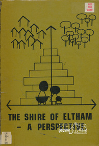
Book, Shire of Eltham, The Shire of Eltham - A Perspective, July 1981
This report was produced by the Shire of Eltham (Planning Department) following a population study of the Shire. It also includes other areas of general interest. The Document contents includes Present and Future - Population - Housing - Residential Lands - Social Characteristics - Development and History. Includes maps, tables and diagrams. Part 1: The Existing situation - introduction, the Shire of Eltham, physical characteristics, historical development, population growth. Characteristics of the population - size and distribution, age / sex, natural increase, migration. Socio-Economic Factors: socio-economic status, employment/workforce, education, other social factors. Housing/ building statistics: characteristics of Housing stock, current residential trends, other types of building activity. Residential Land: existing vacant lots, estimated additional lots. Part 2: The Future. Land availability, the future population.The Shire of Eltham Council resolved on publication of this report "to commend it to the ratepayers as a most valuable resource document". It provides a comprehensive statistical review of the Shire of Eltham, Victoria in 1981 with some population and development predictions for the future.Spiral bound, soft cover, includes indexBarcode and identification markings including stamped "WITHDRAWN" from Heidelberg Regional Library Serviceshire of eltham, planning, population -
Ringwood and District Historical Society
Book - Eureka Plan, Farmer, Mr, Eureka Plan, c. 1930
Created to assist in promotion and sale of land near Ringwood Railway station, following completion of the electric rail to Ringwood..Book containing details of seven delightful and valuable Ringwood properties - Bestpart, Paradur, Hill Top, Greenwood, Creek, Station and School estates. The book has 16 photos and 20 plans and 20 pages. There are multiple copies of pages 20x2; 19x2; 18x4; 17x4 and 20x2. +Additional Keywords: Farmer, Mr -
 Ringwood and District Historical Society
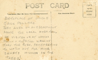
Photographs, Collection of Pollard Photographs, Ringwood (Undated -probably early 1900's). Also Woods Point 1900, circa 1900
Pollard Photographs:; 1. Back of postcard of the Pollard home in Wonga Road (also called Anderson Creek Road Road, and now Warrandyte Road).; 2. One bushel net apples, J Pollard, Victoria, Australia.; 3. Joseph and Emma Pollard and Family. Emma is nursing baby Ethyl.; 4. Ringwood PS photograph. Jack Pollard is second from the RHS in the back row.; 5. Woods Point with arrow indicating mine manager's house: that of Joseph Pollard. Circa 1900. The Pollard family had a 20 acre orcharding property between Mullum Mullum Road and Wonga Road. Given on 4th September 2010 by Arthur Lunt from his cousin. The Pollard family. School photo at Ringwood State School. Jack�s father was Joseph � land (orchard) between Mullum and Wonga Roads +Additional Keywords: Pollard -
Ringwood and District Historical Society
Commercial papers, Aird, J.G, Papers re Land Purchases and transfers between J.G.Aird and others 1919-1924, 1919-1924
Details of monies paid to J.G. Aird and handled by him in connection with the sale of lands.2 bundles of papers pertaining to the collection of monies involved in land purchases and transfers between Mr. J.G. Aird and other parties stapled together in brown folder. +Additional Keywords: Aird, J.G. -
Ringwood and District Historical Society
Agreements, Stillwell and Co, Contracts of sale of land in Ringwood 1911-1925 (Aird Orchard), 1911-1915
Details of contracts of sale of land in Ringwood between 1911 and 1915 executed by Mr Aird - subdivision of orchard between Adelaide Street and Andersons Creek Road (Warrandyte Road). In 1975, the house was the Presbyterian Manse. Orchard owned by J.G. Aird.12 contracts of sale of land in Ringwood between 1911-1915 executed by Mr Aird - buff coloured foolscap bifold documents with black printing and some handwritten. +Additional Keywords: Aird, J.G. -
 Ringwood and District Historical Society
Letter, Trustees Executors and Agency Co. Ltd, letter to the Ringwood Town Clerk from the Trustees Executors and Agency Company Ltd. 1929, 15-Jul-29
Letter indicating the gift of land to establish a Municipal children's playing ground on the death of the owner E.F. Tregaskis sent to the Town Clerk. The land was later sold by the council.Two 2-page letters to the Ringwood Town Clerk from the Trustees Executors and Agency Company Ltd. +Additional Keywords: Tregaskis, E.F. -
Ringwood and District Historical Society
Work on paper - Letter, Letter from W. Meyland to Mr. Hookey re land in East Ringwood for school. 1969, 22-Jul-69
2-page letter from W. Meyland to Mr. Hookey re land in East Ringwood. School was opened 6-Aug-1924 by Mrs. Everard. +Additional Keywords: Meyland, Charles / Hookey / Lindsay, Ted. -
Ringwood and District Historical Society
Land Titles Documents, Titles Department, Documents of land transfer 1911and Certificate of title for land in Pitt Street Ringwood 1920 plus list of names of transferees, 1911 -1920
Photocopies of transfer of land 1920 (poor quality) 1 copy A3, 1 A4. Certificate of title 1920, A4 and list of transferees for land in Bedford Road and Pitt Street Ringwood +Additional Keywords: Walker, E.E Thomas,A / E Thomas,A / Wisemann, A. / Edelsten, E / Unsworth,M -
Ringwood and District Historical Society
Voters' Roll, "Mail" Print Ringwood (Tel 65), Voters' Roll 1924, Borough of Ringwood, South Eastern Province, Ringwood Division, c.1924
Arthur Fisher was the grandfather of Arthur G Lunt, RDHS cataloguer.Voters' Roll 1924, Borough of Ringwood, South Eastern Province, Ringwood Division. Names are marked with red crayon, presumably as vote is made. Brown cover, 39 pages, 703 names. E.Winterbottom, Returning Officer, Borough of Ringwood. Typical examples:Entry 202, Fisher, Arthur, Mullum Road, Orchardist, Owner, House and land, Warrandyte, �40, Votes 1Entry 558, Schwerkolt, Francisco, Mitcham, Owner, House, Ringwood, �22, Votes 1 +Additional Keywords: Fisher, Arthur / Winterbottom, E. / Schwerkolt, Francisco -
Ringwood and District Historical Society
Memoirs, McKellar, Margaret et al, Text of talk to Ringwood Historical Society by Margaret and Ian McKellar - history of "Reaghill" and Davies Family. 2005, 24-Sep-05
The two articles give the history of the land subdivisions over the years, of "Reaghill", a house owned by the Davies family. The history of the land and family was given in a talk to Ringwood Historical Society by the McKellars in 2005.9 type-written pages. Pages 1-4 talk given by Margaret and Ian McKellar to the Ringwood Historical Society and a map. Pages 5-9 history of Reaghill and the Davies Family. +Additional Keywords: McKellar, Margaret / McKellar, Ian / Davies, George / Davies, Dora -
 Ringwood and District Historical Society
Pamphlet, Land Sale Brochure Titled Eureka Plan Book - Seven Delightful & Valuable Ringwood Estates - circa 1925
Twenty page land sale brochure including photographs, subdivision features and local facilities. Additional flyer with conditions of sale and prices for estate blocks.Seven delightful and valuable Ringwood Estates called Bestpart, Paradise, Hill Top, Greenwood, Creek, Station, and School Estates. These nestle amidst the hills and valleys of beautiful Ringwood district. Also Goodluck Estate at Clarinda. Pamphlet marked as being From Mr. Farmer, No. 5 Flinders Court, Melbourne. Phone 988, 989 Central, or 55 Ringwood after 7 p.m. Plan of Ringwood School Estate includes William Street (later Kendall Street), Greenwood Avenue, Alton Street and Locke Street. Plan of Bestpart Estate, Ringwood, includes Bedford Road, Wilana Street, Greenwood Avenue, Caroline Street, Henry Street and Haig Street. Plan of Ringwood Station Estate includes Pitt Street, Bedford Road, Greenwood Avenue, Station Street, William Street (later Kendall Street, James Street, Wantirna Road, Caroline Street, Henry Street, Ellison Street and Haig Street. Plan of Geenwood Estate, Ringwood, includes Prussian Road (later Geenwood Avenue). Plan of Paradise Estate, Ringwood, includes Canterbury Road, Dandenong Road (Wantirna Road), Luck Street and Paradise Road. Plan of Creek Estate, Ringwood, includes Dandenong Creek, Wantirna Road and Gordon Crescent. Plan of Hill Top Estate, Ringwood (later Heathmont area), includes Heathmont Railway Station, Heathmont Road, Balfour Avenue, Lilian Street, Edith Street, Edna Street and Great Ryrie Street. Plan of Goodluck Estate, Clarinda, includes Talbot Avenue, Good Street, Luck Street, and Centre Road in locality plan between Oakleigh and Clayton Railway Stations. -
 Ringwood and District Historical Society
Plan, Paradise Estate Subdivision, Ringwood, Victoria - circa 1925
Paradise Estate layout also included in Land Sale Brochure Titled Eureka Plan Book - Seven Delightful & Valuable Ringwood Estates - circa 1925, Reg. No. 5100.Subdivision plan of Paradise Estate, Ringwood, showing allotments for sale, with typed page attached showing block sizes and prices.Locality plan showing land for sale south of Canterbury Road, 1 Mile south of Ringwood Railway Station. Subdivison includes Canterbury Road and Dandenong Road (later Wantirna Road). Surveyors - McKenzie Aisbett & Webber, surveyors & engineers, 440 Little Collins Street, Melbourne, Telephone Central 11540. Subdivision for Mr Grenwood at Ringwood. Additional typewritten price list showing footage, price per foot, and price per block for Lots No. 1 to 60. Paradise Estate layout also included in Land Sale Brochure Titled Eureka Plan Book - Seven Delightful & Valuable Ringwood Estates - circa 1925, Reg. No. 5100. -
 Ringwood and District Historical Society
Pamphlet, G.A. Green, Auction Sale Brochure - Garden Farms Estate, Ringwood, Victoria - 1919, 1919
Multi-fold brochure advertising public auction of one-acre, 2-acre, 5-acre and 8-acre allotments in Ringwood and Bayswater on Saturday 12th April, 1919. Brochure includes terms of sale, description of subdivision features and local facilities, and photographic images of the area.Subdivison includes Canterbury Road Heathmont, Armstrong Road Heathmont, Armstrong Road Bayswater, Bungalook Road Heathmont, Bungalook Road Bayswater, and Orchard Road Bayswater. Road shown as Bayswater Road to Bayswater became Mountain Highway Bayswater. Vendor: H.E.B.Armstrong, Auctioneers: Coghill & Haughton, 79 Swanston Street Melbourne, Telephone Central 2793, in conjunction with J.B. McAlpin, Ringwood, Opposite Station, Telephone Ringwood 7. (Map) Woodcock & McCormack, Civil Engineers Architects & Surveyors, 430 Little Collins Street, Melbourne, Phone 3241 Central. MOST OF THE MONEY COMES OUT OF THE LAND. And more money can be obtained from anb acre of fruit than from an acre of any other produce. But you do not have to grow fruit on Garden Farms Estate. You can go in for - Outer Suburban Home - Market Garden - Orchard - Pig Raising - Poultry Farm - Small Dairy Farm - Small Fruits - Floral Culture - Scent and Bee Farm - Or just for a Week-end Home. RINGWOOD - THE PLACE TO LIVE. The Beautiful Ringwood District has so many natural attractions, that half a Land Agent's work is done in just showing a prospective buyer round and about. Ringwood has a pull of its own that attracts folk, proved beyond doubt by its rapid development within the last decade (spite the war). First, it is high and healthy, picturesque and undulating, convenient of access, sufficiently close to the Metropolis for City and Business folk to live at Ringwood. Its development is solid, because most of its people are industrious husbandmen, real producers, who have turned idle hills into smiling gardens. These are the kind of real people to live amongst; ones who wear out their spades. The rapidly-developing town has excellent Stores, Trade and Repair Shops Churches, Banks, Telephone Exchange, Weekly General Market, Cool Stores, and good Private and State Schools, etc.; is Electrically lit, has Metropolitan Water Supply, and generally provides so that practically all shopping can be done locally. WHY RINGWOOD MUST GROW. Ringwood is a great centre and must be a greater. Two rapidly-developing railways junction here. The passengers from Ringwood Station cityward, in one year, number 250,000. Ringwood will be the terminus of the Outer Suburban Electric Eastern Railway. Its natural boundaries are the River Yarra on the North, Dandenong Creek on the South, the popular town of Croydon on the East, and the suburb of Mitcham on the West. This is a large territory that is steadily being converted from intense culture, and then it might be called (as regards its gardens) "The Devon Territory of Victoria." ARMSTRONG ROAD. This new road traverses Garden Farms Estate from its northern boundary on the main Canterbury Road, across Dandenong Creek, to its southern boundary on the main Bayswater Road, and will provide a long-desired additional link of communication between Bayswater and Ringwood. The 1-acre building sites on Bayswater Road are within 8 minutes' walk of the Bayswater Railway Station, and the Canterbury Road frontages are only 1-1/2 miles from Ringwood Station, and 1/2 mile from the Railway Station site of Canterbury Road; therefore, the whole Estate is easy of access and there should be a large demand for land so favourably placed. (Image) Cultivation Field - Potatoes on Lot 28 (Image) Picture of Bayswater Creek Flats. (Image) View from "Korumbeen" where Mr. Armstrong lived on Garden Farms Estate. Estate outlined in white ring. (Image) Site of New Bridge over Dandenong Creek. (Image) On one of the timbered lots adjoining railway. (Image) This Dandenong Creek traveres the Estate. (Image) Main Fern Tree Gully Line bisects the Estate. -
 Glen Eira Historical Society
Photograph, Dalny Road, 25, Murrumbeena, 2001
Originally labelled "Beauville Estate, Established 1936, Still Thriving 65 years on, 10th March 2001", the Beauville Estate Album contains colour photographs of houses in the Estate. They were taken around the time of the Beauville Estate’s 65th Heritage Celebration held on 10/03/2001 and donated to the Caulfield Historical Society shortly afterwards. Photographer unknown. City of Glen Eira’s Heritage Management Plan Vol 2 p79 (this is p84 of the pdf version) – HO12 Beauville Estate and environs, Murrumbeena: The Beauville Historic Area is important at the State level as the first large housing estate undertaken by the AV Jennings Construction Co, later Jennings Group Limited, Victoria’s largest home builder. It is important also as a very early estate development incorporating a range of features other than houses and including made roads, shops and recreation facilities. In this respect it was the forerunner of the comprehensively planned housing estate of the post war era. The estate is distinguished by its aesthetic values, as is the earlier and comparable Hillcrest Estate, which are formed by a combination of restrained diversity in house styles, with the exception of no. 30 in the emerging International style, and by a landscaped garden environment. Colour photograph of a light tan rendered brick house with a small curved additional roof jutting over the front door. Other features include tiled roof, white framed windows, door and guttering, feature chimney and a low unpainted variegated brown brick fence in the foreground with bushes and lawn behind the fence. Tall trees behind the house.murrumbeena, houses, architectural styles, 1930's, inter war style, a.v. jennings, av jennings, jennings, brick houses, beauville estate, dalny road, sir albert victor jennings, a v jennings construction co, beauville estate heritage area, glen eira city council, architectural features, jennings group limited, land subdivision, gardens, beauville historic area, rendered houses, chimneys, brick fences -
Glen Eira Historical Society
Article - Service Family
This file contains three items Printed article on James Service from the Australian Sketcher, dated 13/03/1880 Printed article from Victorian and Its Metropolis, by Sutherland, undated Handwritten article on James Service, one short summary taken from Cannon-Land Boomers (page 31) undated. Additional paragraph noting “Servicton” named after him. Handwritten undated list of properties held by James Service from 1876 to 1872, from Rate Books possibly.service james, politian’s, merchants, premiers, kilwinning, house names, mansions, hotham street, balaclava road, james service and co., caulfield north -
 Federation University Historical Collection
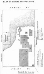
Book - Annual Report 1880, The School of Mines Ballaarat Annual Report, 9 February, 1880, 1880
The School of Mines Annual Report, 9 February, 1881, Additional Examination Statute 1880, Balance Sheet, Certificates Granted by Council, Donations and Fees - carriage of, Extracts from Visitors' Book, Fees, Form of Bequest, Honorary Correspondents, Life Governors, Mining and Mineral Contributions Invited - Paper of Particulars, Museum - open to visitors, Office Bearers, Obituary, Report of the Lecturer in Mathematics, Report of the Lecturer in Mining-Land- and Engineering-Surveying, Report of the Lecturer in Mechanical Engineering, Report of the Lecturer in Telegraphy, Report of the Curator of the Museum (with Plans), Report of the Superintendent of Laboratories, Subjects and Lecturers, Subjects and Examiners, Statement of Receipts and Expenditure for the year 1880, Subscriptions and Donations from 1 January to 31 December 1880, The Lal-Lal Iron Ore Deposits - (with Section and Plan)Pale green booklet of 70 pages, Annual Report 1880. Image of Guage Test Tower, Image of The School of Mines, Plan of Ground and Buildings - Albert Street, The School of Mines Ballaarat - The Museum - Plan of Groundfloor, Image of the Lal-Lal Iron Ore Deposits, Moorabool Riverthe school of mines, annual report, additional examination statute 1880, balance sheet, certificates granted by council, donations and fees - carriage of, extracts from visitors' book, fees, form of bequest, honorary correspondents, life governors, mining and mineral contributions invited-paper of particulars, museum open to visitors, office bearers, obituary, report of the lecturer in mathematics, report of the lecturer in mining-land and engineering-surveying, report of the lecturer in mechanical engineering, report of the lecturer in telegraphy, report of the curator of the museum (with plans), report of the superintendent of laboratories, subjects and lecturers, subjects and examiners, statement of receipts and expenditure for the year 1880, subscriptions and donations from 1 january to 31 december 1880, the lal-lal iron ore deposits-(with section and plan), obituary - sir redmond barry - arthur leahy - jacob upfold - john day, mr james oddie, dr. r. f. hudson, john victor, chas. wm. thomas, w. h. shaw, walter d. campbell, ferdinand m. krause, joseph flude, geo. perry, w. hy. barnard, examination statute, his excellency sir wm. f. drummond jervois, charles h. pearson, t. brodribb, professor pepper, james mitchell, robert adam, wm. lant carperter, h. b. de la poer wall, w. h. brokenshire, arthur parker, henry parkinson, c. davies, simon richards, c. v. gorton, c. r. blackett, david jones, wilberforce dyke, ferdinand krause, ballarat school of mines museum, ballarat school of mines museum plan, lal lal ore deposits, moorabool river, william land carpenter, william jervois, william henry tbarnard -
 Bendigo Historical Society Inc.
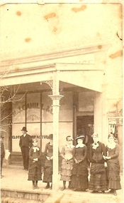
Photograph - SMALL GROUP OUTSIDE M.J. CAHILL'S
Sepia photograph. Six females and two males on footpath outside shop with verandah. Single storey building with narrow land at R. Appears to be washing on line at back of lane. Three females wearing ankle length dresses. Younger females wearing mid-calf length dresses. Inscriptions: in image - on window of shop 'M>J> Cahill & C..', 'Cloth… ..nufactur…'. On back - printed - 'NO. of photograph (1058?), R Dermer Smith. Late of Melbourne and Sydney. Landscape & Architectural. Photographer. Royal Duke Hotel, Bull Street, Sandhurst. Additional copies of this picture may obtained at any time at the above address; single copies Is. Each; 5S per half-dozen. Please enclose the No. of Photograph'.R. Dermer Smithperson, group, adults, sandhurst, history, clothing, fashion, costume, bendigo, retail, business -
 Bendigo Historical Society Inc.
Document - CONNELLY, TATCHELL, DUNLOP COLLECTION: LEGAL DOCUMENTS, 1919 & 1920
Documents. Various legal documents. 1 - 1920 - Sloan John Esq (Bul-A-Bul) Re costs owed Federal Land Tax. 2 - 1920 - Scholten G J. deceased (::Bendigo) RE costs Income Tax. 3 - 1919 - Connell J D & Bailey A D (clo Mr F Lapsley Bendigo) re costs Bogie. 4 - 1920 - Chambers John Jr. (Leichardt) re costs Chambers. 5 - 1920 - Cowling W (Bendigo) re costs Burke. 6 - 1919 - 1920 - Bailey A W Farmer (South Calivil) re costs Mathoura Land and Will. 7 - 1919 - 1920 - Bell Albert J (Leichardt) re costs A D A insurance and Will. 8 - 1919 - Bell S (Chemist Inglewood) re costs Libel. 9 - 1920 - Bagnell L Sr (Mologa) re costs Income Tax Returns. 10 - 1920 Bell James & Co. (:Melbourne) re costs Hogan. 11 - 1919 Butcher W H (Raywood) re costs Shadbolt, McNamara. 12 - 1920 - Bell John (Farmer Leichardt) re costs you from Cocks. Additional names:- McNamara, Bell John, Cocks.cottage, miners, connelly, tatchell & dunlop, sloan john, scholten g j, connell j d, bailey a d, lapsley mr f, bogie, chambers john jr, cowling w, burke, bailey a w, bell albert j, a d a insurance, bell a, bagnell l sr, bell james & co, hogan, butcher w h, shadbolt -
 Finnish Society of Melbourne
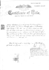
Deed document of Finnish Society of Melbourne, Office of titles Victoria, 1889
The Finnish Society of Melbourne purchased the old Red Robin Hosiery from Nelson Bros. proprietary Limited on the 4th of March 1974. The building was purchased as a home for the Society. On the document there are 9 members as joint proprietors. A trust document was created at the time.Their were joint proprietors. The document was not in the name of the Society. Additional trust document was made at the time.Large document Certificate of Title under the transfer of land staturecertificate of title -
 University of Melbourne, Burnley Campus Archives
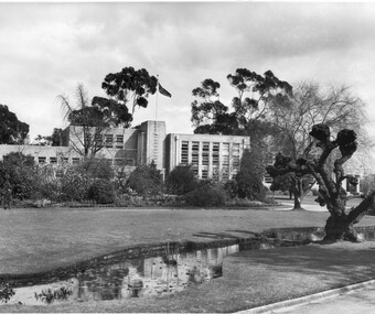
Photograph - Black and white print, Information Branch Victorian Department of Agriculture, Administration Building, 1960-1990
1 copy made by A.P. Winzenried as a possible inclusion in, "Green Grows Our Garden." Note by T.H. Kneen 16 March, 1992, The "Administration Building" referred to frequently in these photographs was the building erected to replace the old Pavilion which housed the School of Primary Agriculture & Horticulture and also the Pasture & Fruit Preserving Branches of the Department of Agriculture. The new building also provided for a future Plant Breeding Branch and some additional facilities such as the Assembly Hall, Library, two additional class rooms." Another comment on 8 April 1992, "The willow, a basket willow, was heavily pollarded annually."3 copies black and white photographs, different sizes. Photograph taken about 1960 showing Administration Building, pond, lawns and garden bed in foreground, student mowing in background. On reverse of 2 copies, "Photograph by Information Branch Victorian Department of Agriculture Ref. No. D1099C." On reverse of 1 copy, "from box the Garden/Land." On reverse, "The Main Building at Burnley photo taken winter approx 1960. This building replaced the original building - The Pavilion."administration building, pond, lawns, garden beds, students, mowing, a.p. winzenried, green grows our garden, school of primary agriculture & horticulture, pasture & fruit preserving branches, department of agriculture, plant breeding branch, assembly hall, library, basket willow, student working outside -
 Whitehorse Historical Society Inc.
Photograph, 'Marple' Orchard Grove Blackburn South
Annie and William Booth, with their five children, left England to migrate to Australia in 1923. They came on the maiden of the S.S.Demosthenes. They bought and occupied land - six and half acres in Orchard Grove, Blackburn South - from 1923 to 1942 when the moved to Salisbury Street, Mont Albert.|William Booth obtained an office position with Danks where he remained till retirement.|The home in Orchard Grove was called 'Marple' after the place in England where the honeymooners.|They ran poultry and an orchard - apples, plums, quinces and peaches which were sold for additional income. This was fairly common at the time for the man to have a job but to use their property for extra income.|The Anglican Church is built on the Booth's top paddockBlack and white photograph of of 'Marple', the Booth family home on Orchard property in Orchard Grove, South Blackburn.marple, booth family, orchard grove, blackburn south, anglican church -
 Parliament of Victoria
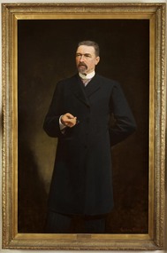
Portrait of Sir James Patterson, Coutts, Gordon 1865-1938, Premier James Patterson, 1893
Premier 23rd January 1893 – 27th September 1894. Born in Alnwick, England, Sir James Patterson (1833-1895) migrated to Victoria in 1852 to try his luck on the goldfields. After little success he turned his hand to farming, and later operated a slaughter yard at Chewton. Patterson served on the Chewton local council, being elected mayor four times before moving with his wife Anna and family to Melbourne in 1870. Patterson established a real estate business, and after two unsuccessful attempts to enter parliament in 1866 and 1868, he won the by election for Castlemaine in the Legislative Assembly in December 1870. He would hold this seat until his death 25 years later. Patterson served in Sir Graham Berry’s brief August to October 1875 government as Commissioner of Public Works and Vice-President of Board and Land Works. He repeated these roles two years later in Berry’s second government and additionally served as Postmaster-General, and in Berry’s third government was Commissioner of Railways and again Vice-President of the Board of Land and Works. In April 1889 after a time in Opposition, Patterson became Commissioner for Trade and Customs in Duncan Gillies’ Government. The following year he returned to the familiar positions of Public Works, Board of Land and Words and Postmaster-General. By 1891 Patterson was leader of the opposition, and when William Shiels’ government succumbed to a motion of no confidence, led by Patterson, he became premier on the 23rd of January 1893. During his premiership, James Patterson was also Chief Secretary and Minister for Railways. His term as premier coincided with a period of severe economic depression, and his enforced economies earned Patterson few public admirers. In May 1893 his government attempted to prevent a run on bank withdrawals and stabilise the sector, by declaring a 5 day 'bank holiday'. Patterson was awarded a knighthood in May 1894, however this did not increase public confidence in his government who were not returned to power in the August 1894 election. Again leader of the opposition, James Patterson died suddenly of influenza on the 30 of October 1895.This portrait was presented to Sir James Patterson by 'grateful citizens of Victoria' in appreciation of his services during the land boom depression. In 1929 the painting was donated to the Victorian Parliamentary Library by H. Lavinia Patterson, the wife of Sir James Patterson's nephew Colonel George Patterson.Oil on canvas, framed. Frame: ornate wood, gesso mouldings, unglazed. Signed on bottom right corner "G. Coutts" Stamped inscription along inner edge of canvas: "WINSOR AND NEWTON". Inscription on canvas, handwritten in ink: "13 1 92" from reverse.patterson, james brown (1833-1895) -
 Melbourne Legacy
Document - Report, Ownership and lease of permanent camp at Balnarring, 1932
Documents concerning Legacy having a legal hold over land owned by Sir Stanley Savige in Balnarring in order to erect permanent camp buildings. 00253.1 and .2 Report of Meeting of sub committee considering the questions of title re permanent camp building at Balnarring. Meeting held at Hotel Austalia 2nd October 1929. Legatees Armstrong, Carleton, Tregent, Hall and Massey in attendence. 00253.3 Signed letter from Charles H. Peters to Brian Armstrong, Messers Plante and Henty Solicitors. 00253.4, .5, .6, .7, .8 Report on Balnarring Camp Property. Same as collection item 00250 but with different corrections and additional notes. 00253.9 Cover letter to L Armstrong signed from Dudley Tregent. 00253.10 Letter to Blatchford, Deputy Chairman Junior Legacy Club from unknown author. 00253.11, .12 Minutes of Meeting of Board of Management. Camp Premises Agreement and negotiations mentioned on page 3. Melbourne Legacy provides camps for junior legatees. The camps gave the children an opportunity of a summer beach holiday with other Legacy children. It started with camps on the property of Legacy founder, Legatee Stan Savige, who had a place in Balnarring, close to the beach. Permanent camp buildings were built in 1930. These documents relate to those buildings. Legacy Somers Camps continued intermittently at Stan's property until it was decided in 1951 to make other arrangements for holidays. Including two other camps in the Somers area: Lord Somers Camp and the Somers School Camp (owned by the Education Department). Camps provided for junior Legatees have been very important from early in Legacy's history. In the 1920s Legacy started camps at Stan Savige's property at Balnarring. By the 1930s a permanent camp kitchen and building had been built at Somers Camp. These documents relate to the official status of the property.White paper with black type x 12 pages relating to land ownership and lease questions around the Balnarring Camp. Six sets of documents kept together. Total of twelve pages, some double sided.land transfer, deed of trust, option to purchase, properties, savige property, legacy somers camp -
 Bendigo Historical Society Inc.
Document - FORTUNA COLLECTION: DOCUMENT
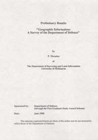
Document - titled : Preliminary Results 'Geographic Information: A Survey of the Department of Defence' Additional written information on title page reads: 'by P. Thwaites at The Deparment of Surveying and Land Information University of Melbourne. Sponsored by: Deparment of Defence (through the Post Graduate Study Award Scheme, Date: June 1988. ' Document is 17 single pages in length including a Contents page.