Showing 291 items
matching bendigo shire
-
 City of Greater Bendigo - Civic Collection
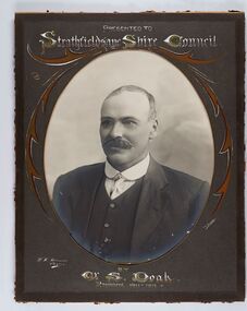
Photograph - Portrait of Councillor Doak, W H Robinson
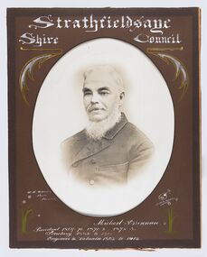
... of Greater Bendigo. The shire was located 8 km to the south- east.... The shire was located 8 km to the south- east of Bendigo and covered ...The district of Strathfieldsaye was proclaimed in 1861 and named a Shire on the 17th September in 1866. It remained a shire until amalgamation in 1994 when it became part of the City of Greater Bendigo. The shire was located 8 km to the south- east of Bendigo and covered an area of 601 square kilometres and extended from the Calder Highway to the Coliban and Campaspe Rivers. The shire's administration centre was in Strathfieldsaye until 1972 when new offices were opened in Kennington.Framed black and white head and shoulder portrait of Councillor Doak with hand coloured and drawn detail. Left facing profile with walrus moustache. Cut oval brown mount decorated with text and scrolls. Hand written title top and lower centre.Presented to / Strathfieldsaye Shire Council / W. H. Robinson / Photo / JMB Gribble / by Cr S. Doak / President 1911 - 1912strathfieldsaye shire council, president of strathfieldsaye shire, councillor doak -
 City of Greater Bendigo - Civic Collection
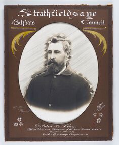
Photograph - Portrait of Councillor Sibley, W H Robinson
... of Greater Bendigo. The shire was located 8 km to the south- east.... The shire was located 8 km to the south- east of Bendigo and covered ...The district of Strathfieldsaye was proclaimed in 1861 and named a Shire on the 17th September in 1866. It remained a shire until amalgamation in 1994 when it became part of the City of Greater Bendigo. The shire was located 8 km to the south- east of Bendigo and covered an area of 601 square kilometres and extended from the Calder Highway to the Coliban and Campaspe Rivers. The shire's administration centre was in Strathfieldsaye until 1972 when new offices were opened in KenningtonFramed black and white head and shoulder portrait of Councillor Sibley with hand coloured and drawn detail. Profile slightly to left with walrus moustache and beard. Cut oval brown mount decorated with text, flowers and scrolls. Hand written title top and lower centre.Strathfieldsaye / Shire Council / W m Robinson / Photo / Bendigo / J N B Gribble / Cr Robert R Sibley / First President Chairman of the Road Board 1865 - 5 / President 1866 - 1869 / With Mrs Sibley's Complimentsstrathfieldsaye shire council, councillor sibley, president of strathfieldsaye shire -
 City of Greater Bendigo - Civic Collection
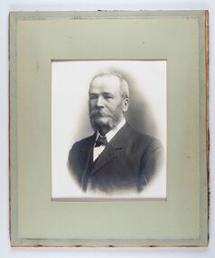
Photograph - Portrait of Councillor Long, Talma & Co
... of Greater Bendigo. The shire was located 8 km to the south- east.... The shire was located 8 km to the south- east of Bendigo and covered ...The district of Strathfieldsaye was proclaimed in 1861 and named a Shire on the 17th September in 1866. It remained a shire until amalgamation in 1994 when it became part of the City of Greater Bendigo. The shire was located 8 km to the south- east of Bendigo and covered an area of 601 square kilometres and extended from the Calder Highway to the Coliban and Campaspe Rivers. The shire's administration centre was in Strathfieldsaye until 1972 when new offices were opened in Kennington.Framed black and white head and shoulder portrait of Councillor Long. Profile to left with walrus moustache and mutton chops. Cut olive retangle mount. Verso; Long. On under board which has photograph attached; Talma & Co. / 119 Swanston St., / Melbournestrathfieldsaye shire council, councillor long -
 City of Greater Bendigo - Civic Collection
Photograph - Portrait of Councillor Hargraves, Bartlett Bros
... of Greater Bendigo. The shire was located 8 km to the south- east.... The shire was located 8 km to the south- east of Bendigo and covered ...The district of Strathfieldsaye was proclaimed in 1861 and named a Shire on the 17th September in 1866. It remained a shire until amalgamation in 1994 when it became part of the City of Greater Bendigo. The shire was located 8 km to the south- east of Bendigo and covered an area of 601 square kilometres and extended from the Calder Highway to the Coliban and Campaspe Rivers. The shire's administration centre was in Strathfieldsaye until 1972 when new offices were opened in KenningtonFramed black and white head and shoulder portrait of Councillor Hargraves. Profile slightly to right with walrus moustache. Cut rectangle brown mount decorated with coloured text and scrolls. Hand written title top and lower centre.Strathfiledsaye Shire Council / Cr John Hargreaves / President 1919 - 20 1928 - 29 / Presented by his Wife & Familystrathfieldsaye shire council, president of strathfieldsaye shire, councillor hargreaves -
 City of Greater Bendigo - Civic Collection
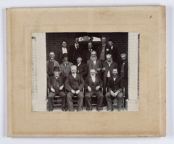
Photograph - Strathfieldsaye Councillor Group Portrait, D.G. Coope & Son - Framers
... of Greater Bendigo. The shire was located 8 km to the south- east... of Greater Bendigo. The shire was located 8 km to the south- east ...The district of Strathfieldsaye was proclaimed in 1861 and named a Shire on the 17th September in 1866. It remained a shire until amalgamation in 1994 when it became part of the City of Greater Bendigo. The shire was located 8 km to the south- east of Bendigo and covered an area of 601 square kilometres and extended from the Calder Highway to the Coliban and Campaspe Rivers. The shire's administration centre was in Strathfieldsaye until 1972 when new offices were opened in Kennington.Silver gelatin framed photographic group portrait of fifteen men taken in the alcove of the Strathfieldsaye Shire Hall. Four men are seated and eleven are standing. Photograph is attached directly to cream mount card. Handwritten note with photograph: 1/ John Burke, 2/ (?), 3/ (?), 4/ RHS Abbott, 5/ M Brennan, 6/(?) 7/(?) 1/. M Condon? 2/ (?) 3/ M Burns, 4/(?) Gentlemen at back are probably council staff.shire of strathfieldsaye, strathfieldsaye shire council, president of strathfieldsaye shire, councillor john burke, councillor r.h.s. abbott, councillor brennan, councillor condon, councillor m burns -
 City of Greater Bendigo - Civic Collection
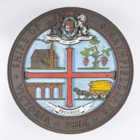
Sign - Shire of Strathfieldsaye Coat of Arms
... of Greater Bendigo. The shire was located 8 km to the south- east.... The shire was located 8 km to the south- east of Bendigo and covered ...The district of Strathfieldsaye was proclaimed in 1861 and named a Shire on the 17th September in 1866. It remained a shire until amalgamation in 1994 when it became part of the City of Greater Bendigo. The shire was located 8 km to the south- east of Bendigo and covered an area of 601 square kilometres and extended from the Calder Highway to the Coliban and Campaspe Rivers. The shire's administration centre was in Strathfieldsaye until 1972 when new offices were opened in Kennington. This coat of arms was commissioned for the front of the shire hall building.Brass painted coat of arms or emblem within a circle of the Shire of Strathfieldsaye. Outer rim contains text: SHIRE OF STRATHFIELDSAYE VICTORIA 1866 with the shield of the monarch of the United Kingdom centre top. The shield is divided into four parts with images reflecting the leading industries of the time; wine growing, mining, farming and tanning. The motto PROGRESS is depicted lower centre of shield. SHIRE OF STRATHFIELDSAYE / VICTORIA / 1866 / PROGRESSshire of strathfieldsaye, city of greater bendigo amalgamation, city of greater bendigo signs -
 Bendigo Historical Society Inc.
Document - BASIL MILLER COLLECTION: TRAMS - CONSTRUCTION MODIFIED AGREEMENT
... of Bendigo, Borough of Eaglehawk and Shire of Marong... between City Council of Bendigo, Borough of Eaglehawk and Shire ...Printed copy of Modified Agreement between City Council of Bendigo, Borough of Eaglehawk and Shire of Marong and the Sandhurst and Eaglehawk Electric Tramway Company Ltd. Re: construction of Tramway in Bendigo Eaglehawk, and Marong Shire.person, individual, basil miller -
 City of Greater Bendigo - Civic Collection
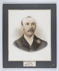
Photograph - Portrait of Councillor Orr, The Yeoman Studios, Ex. Councillor / F. Orr / Eppalock
... of Greater Bendigo. The shire was located 8 km to the south- east.... The shire was located 8 km to the south- east of Bendigo and covered ...The district of Strathfieldsaye was proclaimed in 1861 and named a Shire on the 17th September in 1866. It remained a shire until amalgamation in 1994 when it became part of the City of Greater Bendigo. The shire was located 8 km to the south- east of Bendigo and covered an area of 601 square kilometres and extended from the Calder Highway to the Coliban and Campaspe Rivers. The shire's administration centre was in Strathfieldsaye until 1972 when new offices were opened in Kennington. Eppalock Ward is one of three wards in the Greater Bendigo municipality which includes the former Strathfieldsaye Shire. Framed black and white head and shoulder portrait with hand coloured detail. Man with profile slightly to right, walrus moustache, image encircled. Photograph is attached to mount card. Hand written title lower centre.Ex. Councillor / F. Orr / Eppalock / The / Yeoman / Studiosshire of strathfieldsaye, councillor orr -
 City of Greater Bendigo - Civic Collection
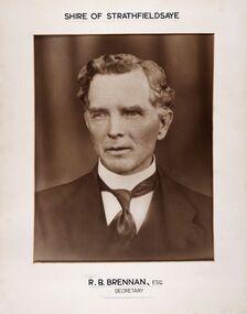
Photograph - Portrait of Shire Secretary Brennan, Unknown
... of Greater Bendigo. The Shire was located 8 km to the south- east.... The Shire was located 8 km to the south- east of Bendigo and covered ...The district of Strathfieldsaye was proclaimed in 1861 and named a Shire on the 17th September in 1866. It remained a shire until amalgamation in 1994 when it became part of the City of Greater Bendigo. The Shire was located 8 km to the south- east of Bendigo and covered an area of 601 square kilometres and extended from the Calder Highway to the Coliban and Campaspe Rivers. The shire's administration centre was in Strathfieldsaye until 1972 when new offices were opened in Kennington. Secretary Brennan, son of Councillor M. Brennan was appointed after his fathers death to the role and according to the The Bendigo Independent was in the role in 1917. See References.Framed black and white head and shoulder portrait of Councillor Brennan. Profile slightly to left. Cut rectangle cream mount. Hand written title top and lower centre. Shire of Strathfieldsaye / R. B. Brennan, Esq / Secretarystrathfieldsaye shire council, secretary strathfieldsaye shire -
 City of Greater Bendigo - Civic Collection
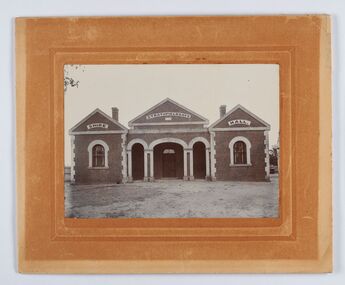
Photograph - Strathfieldsaye Shire Hall
... of Greater Bendigo. The shire was located 8 km to the south- east.... The shire was located 8 km to the south- east of Bendigo and covered ...The district of Strathfieldsaye was proclaimed in 1861 and named a Shire on the 17th September in 1866. It remained a shire until amalgamation in 1994 when it became part of the City of Greater Bendigo. The shire was located 8 km to the south- east of Bendigo and covered an area of 601 square kilometres and extended from the Calder Highway to the Coliban and Campaspe Rivers. The shire's administration activities were centred at the Strathfieldsaye Shire Hall which was built in 1869 at a cost of £700 based on a design by George Steane, the shire surveyor and built by George Pallett of Sandhurst. Constructed of red brick, the hall has a unique ventilation system with hollow walls open at the top and bottom to ensure a draught to cool the building in summer. Framed and mounted photograph of the Strathfieldsaye Shire Hall. Verso; W M Robinson / Photographer / Mundy Street Bendigostrathfieldsaye shire hall, shire of strathfieldsaye, strathfieldsaye shire council -
 City of Greater Bendigo - Civic Collection
Photograph - Portrait of Councillor Brennan, W H Robinson
... of Greater Bendigo. The shire was located 8 km to the south- east.... The shire was located 8 km to the south- east of Bendigo and covered ...The district of Strathfieldsaye was proclaimed in 1861 and named a Shire on the 17th September in 1866. It remained a shire until amalgamation in 1994 when it became part of the City of Greater Bendigo. The shire was located 8 km to the south- east of Bendigo and covered an area of 601 square kilometres and extended from the Calder Highway to the Coliban and Campaspe Rivers. The shire's administration centre was in Strathfieldsaye until 1972 when new offices were opened in Kennington. Councillor Michael Brennan held roles of Shire Secretary and Clark of Works until around 1998 when his son R. B. Brennan was appointed Assistant Secretary and then Shire Secretary to assist his father with the work load during his later years. Michael Brennan remained Clerk of Works until his death at which time his son was appointed to the duties previously held by his father. Framed black and white head and shoulder portrait of Councillor Brennan with hand coloured and drawn detail. Profile to left. Cut oval brown mount decorated with text and flowers. Hand written title top and lower centreStrathfieldsaye / Shire Council / W H Robinson / Photo / Bendigo / J H B Gribble / Michael Brennan / President 1869 - 70. 1871 - 2. 1872 - 3 / Secretary 1882 to 1900 / Engineer & Valuator 1882 to 1902strathfieldsaye shire council, councillor brennan, president of strathfieldsaye shire -
 Bendigo Historical Society Inc.
Document - NORMAN OLIVER COLLECTION: SPEECH NOTES 16 MAY 1`951
... in Carpenter St, annexation of part of Strathfieldsaye Shire to Bendigo... in Carpenter St, annexation of part of Strathfieldsaye Shire to Bendigo ...The Norman Oliver collection. Norman Oliver was three times Mayor of Bendigo - 1950-51, 1964-65, 1970-71. Nineteen typed pages, 1-20 with no page 8. On the left hand margin is written in ink 'Please return to ? John? Hargreaves St'. Notes are dated 16 May 1951 and are in the format he used for his weekly talk on 3BO 'The Mayor Speaks'. Topics include : a crossing in Carpenter St, annexation of part of Strathfieldsaye Shire to Bendigo, shortage of engineers and materials, White Hills swimming pool, Showgrounds conveniences, the Kindergarten, Upper Reserve and school sports, Subdivisions and separate rating, the Centenary train, visit of General Berryman, and the recruiting convoy.bendigo, council, speech notes, norman joseph oliver , councillor norman oliver. mayor. 3bo 'the mayor speaks'. bendigo centenary 1951. -
 Eltham District Historical Society Inc
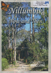
Book, Marguerite Marshall, Nillumbik now and then / Marguerite Marshall; photographs Alan King with Marguerite Marshall, 2008
... Records Office, Bendigo Bank and Nillumbik Shire Council. EDHS... Records Office, Bendigo Bank and Nillumbik Shire Council. EDHS ...Nillumbik Now and Then takes the reader on a journey from when the Aboriginal people were this area's sole inhabitnats, to the present day. Nillumbik's history - told in this collection of 96 stories, which are nearly all based on sites - mirrors those of the wider Australian community. It includes tales of the Wurundjeri people, a former convict, farmers, a bushranger, gold-mining, soldiers, artists, intellectuals, environmentalists and sportspeople. Each story is illustrated with a photograph. As a journalist with the former Diamond Valley News, Marguerite Marshall wrote a series of articles on local places of historic interest, later published as the small book "Eltham Shire - Historic Buildings and Places". Many years later an expanded version was published under the title "Nillumbik Now and Then". This is a much larger version of "Nillumbik Now and Then", including significant rewriting and many additional articles. The new publication was made possible by financial support from the Victorian Public Records Office, Bendigo Bank and Nillumbik Shire Council. EDHS and other historical societies in Nillumbik assisted with content for many of the stories. The book was launched at the Eltham Library on Wednesday 19th November 2008. Source: EDHS Newsletter No 183, November 2009 The front cover art depicts The former house of naturalist and artist Neil Douglas at Bend of Islands, photographer Marguerite Marshall. This collection of almost 130 photos and stories about places and people within the Shire of Nillumbik, an urban and rural municipality in Melbourne's north, contributes to an understanding of the history of the Shire. Published in 2008 immediately prior to the Black Saturday bushfires of February 7 2009, it documents sites that were impacted, and in some cases destroyed by the fires. It includes photographs taken especially for the publication, creating a unique time capsule representing the Shire in the early 21st century. It remains the most recent comprehenesive publication devoted to the Shire's history connecting local residents to the past. Paperback; x, 198 p. : ill., ports. ; 30 cm.Signed by the authornillumbik shire, houses, buildings, weller's hotel, landmarks, bend of islands -
 Bendigo Historical Society Inc.
Document - INDEXES
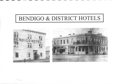
... Helen Mainka 1954 Bendigo Business District Directory... Mainka 1954 Bendigo Business District Directory McConnell’s ...Indexes Includes Names from the 1856 Petition Bendigo and District Hotels Final Marunari List Terry Davidson 1871 - 2018 Index to RHSV Bendigo Branch Newsletters Nov. 1971 - July 2002 Helen Mainka 1954 Bendigo Business District Directory McConnell’s Street and general Directory Date unknown Victorian Directory 1904 Bendigo and District Directory 1904 – 1905 Bendigo district general Directory 1859 City of Bendigo Historical Information Bendigo Hotels compiled by Len Bennetts Hotels of Bendigo and District Compiled by Len Bennetts Sandhurst Land Sales 1854 – 1856 Ralph Birrell Chronicles of Bendigo from the Bendigo Advertiser Christmas Supplement December 22 1904 Some Photographers 1850 – 1900. Including some Bendigo Photographers 1854 – 1958 St. Patrick’s Annual Sports advertisers. Date Unknown Fatalities listed in bendigo Advertiser 1888-1935. Two copies One by year. One alphabetical. District statistics - Mayors and Shire Presidents, Bendigo Football League Premiers 1880- 1987, Sportstar of the year 1965-1987 Plans of townships and Parishes held at Ducley House. From the Bendigo Lands Office 1976. -
 Bendigo Military Museum
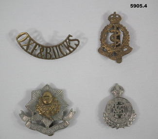
Badge - BADGES, BRITISH, C.1914 - 18 or pre
... Bendigo Military Museum 37 - 39 Pall Mall Bendigo ....1) Oxeford Shire & Buckingham Shires Light Infantry. .3) Cheshire Infantry Regiment. .4) 18th Royal Hussars Cavalry. Items in the collection re John D Gardiner No 2832, refer Cat No 5892.2 for his service details..1) Badge brass curved shape all lettering with two lugs on rear. .2) Badge pressed brass crown at top, wreath and Serpent, scroll at bottom, pin on rear. .3) Badge pressed brass, 8 sided star with central motif, scroll under with raised lettering, pin on rear. .4) Badge pressed silver colour, crown at top, central circle with raised lettering, wreath under and pin on rear..1) "OXE & BUCKS" .2) "Royal Army Medical Corp". .3) "CHESHIRE" .4) Queen Mary's Own". -
 Eltham District Historical Society Inc
Book, Picture Nillumbik, 2012
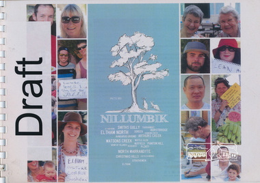
A community-led project to contribute to a vision for the Shire of Nillumbik. Between October 2011 and June 2012, Nillumbik Shire Council undertook a community information gathering project to ask residents "what is your vision for your local community?” Picture Nillumbik represents a collection of responses from community groups, schools and households via online submissions, photos, interviews and workshop contributions. The resulting document provides a snapshot of the values, ambitions and resilience of Nillumbik communities. The project aimed to inform community planning and identify how Council can work better with residents. The resulting document provides a snapshot of the values, ambitions and resilience of Nillumbik communities. Aimed to inform community planning and identify how Council can work better with residents. Further that the document be inspiring, stimulating and a reminder that the future is worth planning for. Includes a number of case studies of local organisations and projects including: Christmas Hills - Butterfly Studios, Strathewen Tree Project, St Andrews mosaic seat, Eltham & District Woodworkers Inc., Edendale Farm - Home harvest, Hurstbridge, Bend of Islands, Bendigo bank, Dunmoochin - Cottles Bridge, Artists Open Studios Program, World Matters and Past Matters, Nillumbik Reconciliation Group, Boots for all. Chapters include: Deep connection and resilient community, local village life, Balance with nature, a sustaining and evolving economy, creative expression, art and cultural exchange, experience discovery and fulfilment and stewarding the Nillumbik way. Each chapter includes further questions for discussion.Spiral bound document printed in landscape format. Includes text and colour photographs. 196 pagesSmall piece of paper headed "DRAFT" included at the front of the document when bound.shire of nillumbik, planning, future, christmas hills, strathewen tree project, st andrews, eltham & district woodworkers inc., edendale farm, bend of islands, dunmoochin, artists open studios program, nillumbik reconciliation group, community groups, vision, strategy -
 Eltham District Historical Society Inc
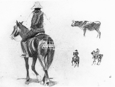
Photograph, Walter Withers, Pencil drawing from a sketch book by Walter Withers; figure study of man on horse with cow
Pencil drawing from a sketch book by Walter Withers. Held by the National Gallery of Victoria. Featured on p82 of "Pioneers and Painters". The figure study is reproduced in Wither's 'The Drover' (1912) held by Bendigo Art Gallery. The model was Mr W. J. Capewell, the Eltham Butcher.This photo forms part of a collection of photographs gathered by the Shire of Eltham for their centenary project book,"Pioneers and Painters: 100 years of the Shire of Eltham" by Alan Marshall (1971). The collection of over 500 images is held in partnership between Eltham District Historical Society and Yarra Plenty Regional Library (Eltham Library) and is now formally known as the 'The Shire of Eltham Pioneers Photograph Collection.' It is significant in being the first community sourced collection representing the places and people of the Shire's first one hundred years.Digital image Print (x2)horse, pioneers and painters, sepp, shire of eltham pioneers photograph collection, sketches, the drover 1912, w.j. capewell, walter withers, walter withers sketch -
 Eltham District Historical Society Inc
Folder, Pioneers & Painters; Shire of Eltham Historical Society research notes, background information, etc, 1969-1986, 1969-1986
Material pertaining to the production of a history of the Shire of Eltham, "Pioneers & Painters: One Hundred Years of Eltham and its Shire" in recognition of the shire's centenary in 1971 Item Title Caption 04768-1 Newspaper clipping - The Eltham of 1905; Gellibrand our first white visitor? Diamond Valley News, 24 June 1969, p5 04768-2 Newspaper clipping - The Eltham of 1905; Gellibrand our first white visitor? Heidelberger, 25 June 1969 04768-3 Notes on Eltham District Road Board Members 1866-1871 04768-4 Notes on Eltham District Road Board Members 1866-1871 04768-5 Map showing Gellibrand's likely route through district 12-13 February 1836 and Hoddles's route of Febrary 1838 04768-6 Notes by Shire Secretary, M.B. Watson regarding meeting with Reverend Longfield regarding history of St Margaret's Church 04768-7 Alan Marshall's notes from discussion with Mr. F. Barrett regarding SEPP images 611, 635 and 636 SEPP_0611 SEPP_0635 SEPP_0636 04768-8 Transcripts of letter from local residents to Charles Joseph Latrobe requesting a bridge over the Plenty River dated 10 April 1849 and his reply dated 5 May 1849; from Latrobe Library Archives - Land Branch Records 04768-9 Notes on history of Eltham Shire, Centenary events and publication of Pioneers & Painters for release in conjunction of opening of new Library 04768-10 Newspaper clipping - Glossy record of shire's romantic past and the people who made it by Fab Calafuri, Diamond Valley News, Tuesday, December 16, 1986, p18 SEPP_0755-3 Letter: Acknowledgement from Colin J. Bock, Eltham Shire Secretary to A.R. Thomas of Bendigo for copy of 1913 photograph of Shire of Eltham Councilors, 21 May 1973 A.R. Thomas' father Mr. A.G. Thomas, C.E., was the Shire Secretary at the time in 1913. Cross Ref: SEPP_0755 The idea to develop a book on the history of the Shire of Eltham to be edited by noted author, Alan Marshall in celebration of the shire's centenary was initiated in 1969. The Shire of Eltham Historical Society undertook significant research in conjunction with Alan Marshall locating material at various institutions and other societies; interviewing longer term residents and a public campaign through the local press to acquire photographic material for duplication and use in the book. The public campaign received generous response and the material collected became the genesis for the Shire of Eltham Pioneers Photograph collection now held in partnership between Eltham District Historical Society and Yarra Plenty Regional Library (Eltham Library).Paper documents of various sizes and newspaper clippingsa.g. thomas, a.r. thomas, alan marshall, bridge road, charles joseph latrobe, council members, d.w. lachlan, eltham district road board, eltham shire council, ernie orford, f. barrett, francis rogerson, g. bransprone, james donaldson, james johnston, john bell, john thomson, joseph tice gellibrand, lower plenty bridge, m.b. watson, main road, map, patrick turnbull, peter morris, pioneers and painters, post office, rev. longfield, sepp, shire of eltham pioneers photograph collection, shire secretary, st margaret's church, thomas armstrong, thomas bell, thomas sweeney, william bell (1796-1870), centenary celebrations, christmas hills, clifton pugh, david newbury, dudley street, eltham, gareth jones roberts, hurstbridge, john perceval, joy peck, kangaroo ground, kinglake, lower plenty, luther haley general store, montmorency, neil douglas, panton hill, peter glass, research (vic.), sheila ferguson, shire of eltham, st andrews, yarra glen -
 Bendigo Military Museum
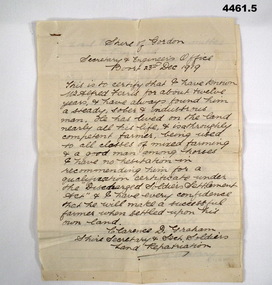
Letter - LETTERS, SOLDIER SETTLEMENT, Shire of Gordon, C. 1919 - 1920
Letters cover recommendations to support the application of Alfred G Ferris for a Soldier Settlement block dated 1919 - 1920, signed by local dignitaries. Alfred G Ferris No 2156 AIF, Refer cat No 4183.3P for his service details.Letters, 5 pages on ruled paper, hand written in ink, stapled together with metal staple.soldier settlement, post ww1, qualification certificate -
 Bendigo Military Museum
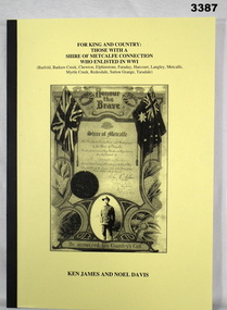
Book - BOOK WW1, For King & Country. Those with a Shire of Metcalfe Connection who Enlisted in WWI, 2009
... Bendigo Military Museum 37 - 39 Pall Mall Bendigo ...Soft light cardboard cover. Yellow background, black print on font. Black buckram spine. Black & white photo of a certificate - Honour the Brave for the Shire of Metcalfe. 281 pages, cut, plain, white. Illustrated in black & white, photos, certificates, maps, lettersHandwritten in black ink on Table of Contents along with "RSL Stamp" "Peter C Ball" (Signed off the donation) book, shire of metcalf -
 Bendigo Military Museum
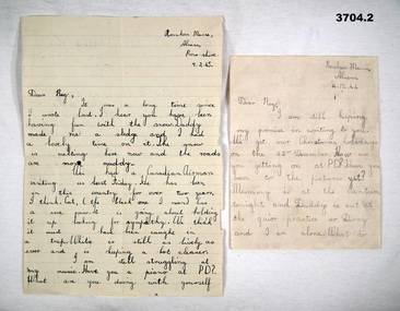
Work on paper - LETTERS, 1) 7.2.1945; .2) 14.12.1944
.1) Letter from Rosskeen Manse Alness, Ross-shire is written by Bess with a short addition from her mother. .2) Letter from same address as .1) by Bess. R C ALLARDICE No 418577 RAAF. Refer Reg No 3627.5 for his service history & collection..1) Letter written on both sides in blue ink to R C ALLARDICE (Reg), ruled lines, paper is off white colour. .2) Letter written on both sides in pencil to R C ALLARDICE (Reg), ruled lines, paper is off white colour.pet cats, xmas holidays -
 Bendigo Military Museum
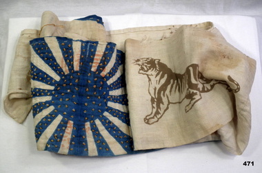
Clothing - SASH/BELT, C.1930 - 45
centre section is double thickness with blue- rayed sun ; blue sections are decorated with gold coloured cotton french knots symbolizing the district shire where the owner lived. A Khaki coloured tiger faces inwards each end of center. Japanese characters in pink near center shashiko quilting on white rays.costume accessories - male, japan, handcrafts - sewing/ embroidery -
 Bendigo Military Museum
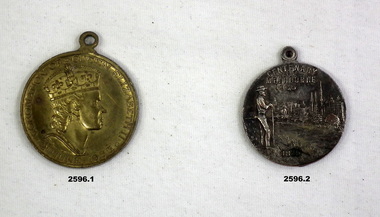
Souvenir - MEDALLIONS, 1) c. 1954, .2) 1934 - 35
items in collection re Brig E.M. Williams, refer Cat No 2580 for service details..1) Medallion, metal, gold colour, Shire of Doncaster & Templestowe, Queen one side & x 2 shields the other. .2) Medallion, metal, silver colour, Centenary of Melbourne & Victoria 1934-35, Depiction of Portland Harbour one side & farmer overlooking Melbourne the other.numismatics, civic mementoes, metalcraft -
Glenelg Shire Council Cultural Collection
Painting - Painting - Oil on Board, Treloar, Sister of Florence Millard, n.d
Painting, oil on board. Floral design red and white flowers, greenish-grey background. Gilded wooden frame. Two eyelets, wire for hangingBack: Picture framer's sticker, white, blue print. DG Coope and son, Bendigo -
Glenelg Shire Council Cultural Collection
Painting, (Untitled - still life), n.d
Painting, oil on board. Floral design, white flowers, green foliage, greenish-grey background. Gilded wooden frame. Two eyelets, wire for hangingBack: Picture framer's sticker, white, blue print. 'DG Coope and son, Bendigo -
 Heathcote McIvor Historical Society
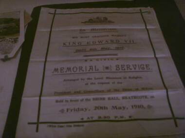
Memorial booklet, shire of mcivor, minsiters of religion, Silk Memorial Booklet Death of King Edward VII 6 May 1910, 06/05/1910-20/05/1910
Created for the memorial service that was held on friday 20th may 1910, held in front of the shire hall in Heathcote to honour king edward VII who died on the 6th may 1910 at 2.30 p.m. this was arranged by the local ministers of religion at the request of the president and councillers of the shire of McIvor.Believed to be the only one in exsistence, after intesive research have been unable to come up with any information, from the shire, local churches or senior members of the community,only mention was in the Bendigo Advertiser newspaper.research in to archives further afield have not produced another.Piece of cream silk printed on face and inside, screen printed in purple and black ink on front and inside the order of service. details of all ministers of religion and shire dignitries as well as hyms sung. "McIvor Times" Print, Heathcote on left hand side below main print. in black inkvictoria, silk memorial booklet, king edward vii, 1910, heathcote, ministers, of, local, churches, shire, president, mcivor, times -
 Eltham District Historical Society Inc
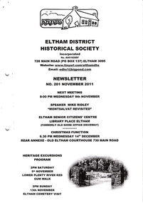
Newsletter, Newsletter, No. 201 November 2011
Contents: • Next meeting, guest speaker; Mike Ridley: Montsalvat Revisited • November Meeting • Lower Plenty River Red Gum Walk • Eltham Cemetery Visit • Christmas Function • 200 Newsletters – More to Come • A Brief History of the Bonds Road Area, Lower Plenty (From Newsletter No. 3, September 1978) • Grant from the Bendigo Bank • From Our Newspaper Files contributed by Harry Gilham • And Also The Shire of Eltham Historical Society was formed in October 1967. The first newsletter of the Society was issued May 1978 and has been published continuously ever since on a bi-monthly basis. With the cessation of the Shire of Eltham in late 1994, the Society's name was revised to Eltham District Historical Society and this name first appeared with issue No. 103, July 1995. The collection of the Society's newsletters provides a valuable resource on the history of the Society's activities, office bearers and committee members, guest speakers and subjects of historical interest pertinent to the former Shire of Eltham and the Eltham District.A4 photocopied newsletter distributed to membersnewsletter, eltham district historical society, shire of eltham historical society -
 4th/19th Prince of Wales's Light Horse Regiment Unit History Room
Print, A V Gregory, HMS Susan, 1934 (exact)
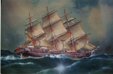
HMS Susan sailed from the Port of London on the 23rd September 1835. She carried 394 male convicts and a guard of officers and 30 rank and file of the 28th (North Gloucestershire) regiment, arriving in Sydney on 8th February 1836. Samuel Windridge, who was born in Warwickshire in 1817, was a Private in the Regiment on board the ‘Susan’. He served in various places: Sydney, Moreton Bay (Brisbane) and Port Phillip (Melbourne). He was discharged from the Regiment in 1842 with the rank of Sergeant. After his marriage he settled in Victoria and by 1852 he was often in charge of the gold escort from Bendigo. In 1854 he retired from the Gold Commission and settled in Kyneton. In 1860 the Kyneton Mounted Rifle Corps was formed with Samuel Windridge as one of its earliest members. In 1862 the ladies of Kyneton presented a standard to the Rifle Corps. In 1976 the Shire of Kyneton presented the Kyneton Colours to the 4th/19th Prince of Wales’s Light Horse Regiment Museum. In 1862 the whole of the Victorian Horse was amalgamated into one Regiment: The Prince of Wales Light Horse. Samuel Windridge rose to the rank of Lieutenant Colonel in the Kyneton Troop of the regiment. He died in 1896, aged 79 years, This painting is a gift from his Great Grand-daughters Mrs Mary Hopper and Miss Jean Baldwin. Framed reproduction of painting of HMS Susan. Wood frame, glass frontA V Gregory on proper left bottom corner of print On bottom right of print: H.M.S Susan 'Southward of the Cape' Arrived in Sydney Feby 1836paintings, kyneton, prints, hms susan, samuel windridge, a v gregory -
 City of Moorabbin Historical Society (Operating the Box Cottage Museum)
Newsletter, City of Moorabbin Historical Society Feb 2010 pdf, February 2010
The City of Moorabbin Historical Society was formed c 1960 by a group of Moorabbin residents who were concerned that the history of the area should be preserved. A good response to a call for items related to the historical area of Moorabbin Shire brought donations of a wide variety of artefacts which are now preserved by the current members of CMHS at Box Cottage Museum . Helen Stanley, Secretary of CMHS, began producing a Newsletter for members in April 2007 to provide current information and well researched items of historical interestHelen Stanley has produced a bi-monthly Newsletter, 2007 - 2013, for the members of the City of Moorabbin Historical Society that contains well researched interesting historical items, notification of upcoming events, current advice from Royal Australian Historical Society , Museums Australia Victoria and activities of Local Historical Societies. The Newsletter is an important record of the activities of the CMHS5 x A4 paper printed on 1 side Issue 15 of the bi-monthly, City of Moorabbin Historical Society Newsletter produced by Society member and Secretary, Mrs Helen Stanley in February 2010. Notices for the meeting February 28th , subscriptions due, and this is 50th Anniversary of CMHS. Water flooded Joyce Park, the grounds of the Cottage and a little seeped into Grace Lewis Room in December 2009 when a water main at the neighbouring Bowling Club burst, but little damage occurred and the Glen Eira Council will install drainage pipes between Box Cottage and the Bowling Club. In January, 2 brush tailed possums had taken up residence in the Barn and after failed attempts by Helen and Dennis to move them, Glen Eira Council relocated them. A description of the establishment of Cobb & Co Coaches by Freeman Cobb in 1853, for cartage between Melbourne and the Ports but they soon began transporting people and mail to the gold fields around Victoria. 3 photocopied photographs of Cobb & Co Coaches and 1 photo of the 2 Possums CITY of MOORABBIN HISTORICAL SOCIETY / February 2010 NEWSLETTER city of moorabbin historical society, stanley helen, maynard dennis, melbourne, moorabbin, cheltenham, ormond, bentleigh, market gardeners, pioneers, early settlers, moorabbin shire, box cottage museum, lewis grace, cobb freeman, cobb and co coaches, ballarat, goldfields, gold miners, bendigo, castlemaine, governor latrobe, victoria, sydney road, sutherland alexander, chinese gold miners -
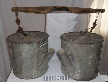 City of Moorabbin Historical Society (Operating the Box Cottage Museum)
Tool - Chinese Market-Gardener's Watering-Cans
Chinese market-gardener’s watering-cans on a wooden yoke. This item was authenticated by the Bendigo Historical Society, and is said to be quite rare. It consists of two large galvanized watering-cans each with a pouring spout, suspended by chains from a well-used wooden yoke. The cans would each have been filled with water, then carried a distance into the market garden and used to water crops. The cans and yoke alone are very heavy, one can only imagine how heavy they were when filled with water.As profits from the gold-fields petered out the Chinese immigrants, (nearly all single men), were forced to seek other occupations. Many moved into furniture building in the East Melbourne area, whilst others went into market gardening . A significant number of Chinese men, realising the potential of the sandy, fertile soil, with a good supply of water, in the Shire of Moorabbin, leased tracts of land in that area to establish a market garden and grow produce for the increasing population of MelbourneAfter the Dendy Special Survey in1841in Brighton, Victoria, the first sale of Crown Land, taking in the whole Shire of Moorabbin, occurred in 1852. These allotments of land were eagerly bought up - some by speculators - although many were either worked by the owner, or leased out as market gardens and "fruit gardens", (orchards). Chinese market-gardener’s watering-cans suspended by chains on a wooden yoke. This item was authenticated by the Bendigo Historical Society, and is said to be quite rare. It consists of two large galvanized watering-cans each with a pouring spout, suspended by chains from a well-used wooden yokebrighton, gardeners, bentleigh, orchards, vegetables, dendy henry, market gardens, chinese settlers, pioneers moorabbin, water wells, creeks