Showing 457 items matching "cheltenham road"
-
 City of Moorabbin Historical Society (Operating the Box Cottage Museum)
Flyer - Ozone Hill Estate, Cheltenham, 1923
... Road Cheltenham real estate auction Ozone Hill Estate ...The train line from the city to Frankston was electrified in 1922 which intensified the sale in the municipality of Moorabbin, particularly land which was in the vicinity of the railway stations.Example of the progress of the Municipality of MoorabbinPhotocopy of Advertising flyer for sale of real estate sales - plan of building blocks for saleOzone Hill Estate, Cheltenham 41 choice residential allotments.victor avenue, weatherall road, cheltenham, real estate, auction -
 Federation University Historical Collection
Book, William J. Goudie, Steam Turbines, 1922, 1922
... Road Cheltenham"... Nepean Road Cheltenham" Green hard covered book Steam Turbines ...Green hard covered bookInside front cover "R.F. Symons Holmby Lodge Point Nepean Road Cheltenham"steam, r.f. symons -
 City of Kingston
Photograph - Black and white, c. 1925
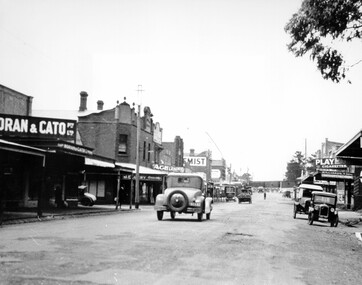
... Black and white image of Charman Road, Cheltenham... text on a white strip of paper adhered to reverse: Charman Road... to reverse: Charman Road, Cheltenham / circa late 1920's/early 1930's ...This image explores the relationship between the train lines and community development. Cheltenham's retail centre is connected to the train station.Black and white image of Charman Road, Cheltenham, depicting a car and truck travelling toward the level crossing near the train station. There is another car already waiting at the crossing gates. Cars are parked on either side of the road along a shopping strip.Black printed text on a white round sticker adhered to the reverse: 141 Handwritten in red ink on reverse: 50% Black typed text on a white strip of paper adhered to reverse: Charman Road, Cheltenham / circa late 1920's/early 1930's / $50 reproduction fee applies Blue ink stamped on reverse: COPYRIGHT / Public Transport Corporation / For re-ordering photographs / Please quote negative ADV 485 / Enquiries C/- PTC Photographic Unit / Telephone switchboard 619 1111cheltenham, trains, railway, railway crossing, shopping strip, cars -
 City of Kingston
Photograph - Black and white, c. 1900
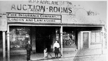
... W.P. Fairlam Auction Rooms was located on Charman Road...City of Kingston Parkdale Library 96 Parkers Road, Parkdale ...W.P. Fairlam Auction Rooms was located on Charman Road, Cheltenham, Victoria. The Fairlam family were a prominent family among early settlers in the Cheltenham area. While William Percy Fairlam ran the auction rooms, his son Richard William Percy Fairlam ran a photography business next door. Many of the photographs in our collection from the early 20th Century are the work of Richard William Percy Fairlam.Black and white image of a man with a moustache, dressed in a three piece suit and wearing a cap, standing outside the W.P. Fairlam Auction Rooms in Cheltenham, Victoria. Standing beside him is a girl and between them a dog is sitting on the ground. The man is William Percy Fairlam and the girl is his daughter Addie Fairlam.Handwritten in blue ink on reverse: 73 Handwritten in red ink on reverse: 51%fairlam, commerce, cheltenham, family -
 City of Kingston
Photograph - Black and white, 17 January 1951
... Road, Moorabbin (bottom left), Centre Dandenong Road Cheltenham... Dandenong Road Cheltenham (top left), Park Road, Cheltenham (top ...Moorabbin, Cheltenham and Highett are suburbs in the City of Kingston with a diverse mix of development and zoning. This 1954 image shows the market gardens, farms and paddocks of the Moorabbin and Cheltenham area. which have gradually been sub-divided into The Highett Gas Works is visible and Cheltenham Park and Victoria Golf Club.The suburbs of Cheltenham and Moorabbin were originally developed with extensive market gardens. Over time the district has been transformed with the farms and paddocks replaced by housing, factories and shopping centres. The Highett Gas Works on the Nepean Highway was a significant feature of the landscape and has now been demolished. and the site has undergone remediation.Aerial photograph of Cheltenham, Moorabbin and Highett within the City of Kingston. The area depicted in this 1951 aerial view includes Wickham Road, Highett (bottom right), Keys Road, Moorabbin (bottom left), Centre Dandenong Road Cheltenham (top left), Park Road, Cheltenham (top right), Nepean Highway (left section), Graham Road and Middleton Street, Highett (bottom right). Cheltenham Park and Victoria Golf Club are visible. Nepean Highway and the Frankston railway line run centrally through the image.White type: 1416-37 538 RUN239 LENS 5312" MELBOURNE METROPOLITAN 12150 17-1-51 ↆ M539 Black pencil: N [arrow]cheltenham, highett, highett gas works, market gardens -
 City of Kingston
Pamphlet - Colour, Stillwell and Co, Cheltenham Charman Estate Realising Auction, 1921
... Sales plan for land in the suburb of Cheltenham, along...City of Kingston Parkdale Library 96 Parkers Road, Parkdale ...Sales plan for land in the suburb of Cheltenham, along Charman Road and Weatherall Street.The developing urban area of Cheltenham within the City of Kingston. This land sale pamphlet illustrates the subdivision of land within the municipality and the changing demographic of the district as new houses are constructed.Colour pamphlet advertising realising auction of the Charman Estate, Cheltenham. Incorporates a map of the estate, showing subdivisions along Charman Road and Weatherall Street.land sales, cheltenham, estate -
 City of Moorabbin Historical Society (Operating the Box Cottage Museum)
Print - 'Spring Grove' 19thC house, c1979
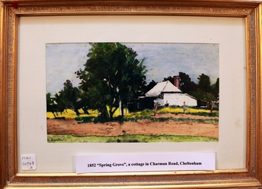
... by Charman Rd and Balcombe Road in an area called Spring Grove, later... was the first house in Charman Road Cheltenham c1852... of the weatherboard cottage was on, a road which runs from Cheltenham ...In 1852 Stephen Charman purchased 160 acres bounded by Charman Rd and Balcombe Road in an area called Spring Grove, later Cheltenham. A spring ran through the land providing a good source of water. Stephen aged 21 years had arrived in Melbourne 1842 as one of Henry Dendy’s emigrants . His Ship passage was paid by the Colonial Land and Emigration Commission and in return he was required to work on the land of the Henry Dendy Special Survey Brighton 1841. However Henry Dendy could not provide enough work for all the emigrants that arrived and Stephen had to obtain other work. Then sadly his young wife Harriett and their infant died. 1850 Stephen married widow Mary Gettens, a Publican in Little Collins Street, with 5 children. Stephen & Mary built a wattle and daub hut and established a market garden producing marigolds for Martin & Pleasance Pharmacists, Melbourne. They had 7 more children and built a weatherboard cottage that was used for early Methodist Church services. Stephen donated 1 acre to the Methodist Church in 1855 for Chapel , School and Cemetery. The picture of the weatherboard cottage was on, a road which runs from Cheltenham to Mentone it bears their name. Charman Road. Mary died in 1870 and Stephen remarried 1878 and died in Gippsland 1906. Stephen and Mary Charman were pioneer settlers in the area of Spring Grove later known as Cheltenham . Charman Road Cheltenham commemorates their contribution to the development of the area. A painting of 'Spring Grove' the home of Stephen Charman and Mary Charman formerly Gettens nee Rees, This cottage was the first house in Charman Road Cheltenham c1852signed L Schumerspring grove cottage 1852, schumer l, cheltenham, charman stephen, early settlers, jones a l, gettens mary, rees mary, charman mary, moorabbin, brighton -
 City of Kingston
Photograph - Black and white, c. 1910
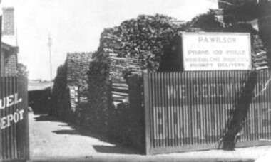
... Percy Wilson's woodyard was on Point Nepean Road...City of Kingston Parkdale Library 96 Parkers Road, Parkdale ...Percy Wilson's woodyard was on Point Nepean Road, Cheltenham. Wilson was the local wood man and fuel merchant. Black and white image of a wood yard with a corrugated iron fence. Advertising is painted on to the fence, indicating they also sell briquettes. There is a sign on top of the fence including the business name, phone number and that it sells wood, coal, coke, and briquettes.cheltenham, wood, coal, briquettes, commerce, domestic -
 City of Kingston
Photograph - Black and white, c. 1950
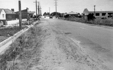
... and Centre Dandenong roads, Cheltenham. On the left hand side... was crucial to the ongoing development of the area. Cheltenham Roads ...While the road is sealed, there is evidence of potholes that have been filled, and the wide, gravel shoulder has long grass running into the gutter of the nature strip. On the other side of the road, extremely long grass can be seen growing on the side of the road. There is a truck visible on the road, which indicates the rural nature of the Cheltenham community in the 1950s.This image is one of many in the collections that focuses on the railway or roads. The development of roads and the railway was crucial to the ongoing development of the area. Black and white photograph of the intersection of Warrigal and Centre Dandenong roads, Cheltenham. On the left hand side is a small sign warning of a cross roads intersection. Housing and shops line the road.Handwritten in blue ink on reverse: 219 Handwritten in red ink on reverse: 80%cheltenham, roads, suburbs -
 City of Kingston
Photograph - Digital image, Black and white, Cheltenham Tennis Club, c. 1910
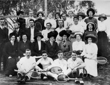
... Cheltenham Tennis Club, Park Road, Cheltenham Back (left...Cheltenham Tennis Club, Park Road, Cheltenham Back (left ...Cheltenham Tennis Club, Park Road, Cheltenham Back (left to right) Carrie Hayman, Clem Phillips, Anne Chandler, J Woods, Eugenie Fairlam, J Francis, W Foreman, Maggie Maxwell, Fanny Woff, Minnie Cullen, Third Row: Dr A Weigell, Edwards, C Scantlebury, WoBlack and white image of a group of men and women standing courtside with rackets in their handsRound red sticker:X2 [crossed out] Handwritten in blue ink enclosed in a circle:49 / written in pink ink 50%tennis, cheltenham, cheltenham tennis club, sport -
 City of Kingston
Photograph - Black and white, 1903
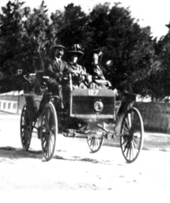
... ) driving an early car along Charman Road, Cheltenham. There are two... Scantlebury) driving an early car along Charman Road, Cheltenham ...The Scantlebury family moved to Cheltenham from Linton. The father, George, was a medical practitioner. His daughter, Vera, became an early woman graduate of medicine at the University of Melbourne. His son, Clifford, also became a medical practitioner.Black and white image of a man (Dr George Scantlebury) driving an early car along Charman Road, Cheltenham. There are two women in the car as well. Cheltenham Cemetery can be seen in the background.Handwritten in black ink on round red sticker: X17 [scribbled over] Handwritten in black ink inside a circle: A4 Handwritten in red ink inside a black ink circle: 60% Handwritten in black ink: Dr Scantlebury's motor car Handwritten in blue ink: Ch4scantlebury, cheltenham, medicine, cars -
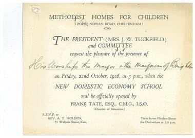 Uniting Church Archives - Synod of Victoria
Document - Invitation, Methodist Homes for Children New Domestic Economy School
... at the Methodist Homes for Children, Point Nepean Road, Cheltenham... Nepean Road, Cheltenham. E3000.30.2 Copy of reply sent. Typed ...E3000.30.1 White card printed invitation to the Mayor and Mayoress of Brighton to the opening of the domestic economy school at the Methodist Homes for Children, Point Nepean Road, Cheltenham. E3000.30.2 Copy of reply sent. Typed on pink paper.methodist homes for children, tuckfield j w mrs, tate frank -
 City of Kingston
Photograph - Digital image, Black and white, Patients arriving at Melbourne Benevolent Asylum, Kingston Centre, 1911
... Centre, Warrigal Road, Cheltenham, March 1911. 513 patients... Centre, Warrigal Road, Cheltenham, March 1911. 513 patients ...Patients arriving at Melbourne Benevolent Asylum, Kingston Centre, Warrigal Road, Cheltenham, March 1911. 513 patients transferred from North Melbourne. 313 were bedridden.Black and white image of men and women patients arriving at the benevolent asylum with the steps to the building in the background and patients being carried on stretchers from two trucks into the centrePrinted in black text a round white sticker: 82 Hand written in red ink: 52%cheltenham, benevolent asylum, kingston centre -
City of Kingston
Photograph - Black and white, 5 January 1984
... (top left), Weatherall Road and Reserve Road, Cheltenham... left), Weatherall Road and Reserve Road, Cheltenham/Beaumaris ...Moorabbin, Cheltenham and Highett are suburbs in the City of Kingston with a diverse mix of development and zoning. The market gardens, farms and paddocks have gradually been sub-divided into housing and industrial estates and associated infrastructure such as schools and shopping facilities. The area includes many parks, reserves and golf courses.This aerial image covers a diverse section of the City of Kingston, taking in the suburbs of Cheltenham, Moorabbin, Beaumaris and Highett. By 1984, the market gardens of the district have been replaced by housing and factories. The Gas and Fuel state-of-the-art Scientific Services Department is visible on Nepean Highway Highett. The CSIRO Highett site can also be seen. Both sites have now been demolished and have undergone remediation. The Southland site is visible and yet to be redeveloped by Westfield. This image portrays the diversity of development in the City of Kingston with a mixture of green spaces, housing and commercial and industrial features.Aerial photograph of Cheltenham, Beaumaris, Moorabbin and Highett within the City of Kingston. The area depicted in the 1984 aerial view includes Eden Street and Edward Street, Cheltenham (top left), Weatherall Road and Reserve Road, Cheltenham/Beaumaris (top right), Turner Road and Chesterville Road, Moorabbin (bottom left), Nepean Highway (left section), Graham Road and Middleton Street, Highett (bottom right). A large section of this image includes Cheltenham Park and Victoria Golf Club.White text: 3831-219 Lens information [indecipherable] RINGWOOD M/S 7922-3 RUN 15 Clockface image 5,300' ASL VIC DLS© 5-1-84cheltenham, highett, industrialisation, urbanisation, moorabbin, beaumaris -
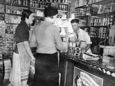 City of Kingston
Photograph - Black and white, c.1930
... Charman Road, Cheltenham in the 1930's. Alan Hutchins is the shop... Charman Road, Cheltenham in the 1930's. Alan Hutchins is the shop ...This photograph shows Judd's Grocery Shop located at 224 Charman Road, Cheltenham in the 1930's. Alan Hutchins is the shop attendant, serving two patrons; Merle Judd (left) and Marion Elliott (right). Judd's Grocery Shop was opened by Clarence Judd in the 1920's and was a successor to the family's business formerly located on the corner of Centre and East Boundary Roads, East Bentleigh. Cheltenham had become an established village during the 1920's and Charman Road represented a second, more commercial development in the area. Black and white photograph of a grocery shop interior displaying a variety of items for sale. A male stands behind a counter, looking at the camera. Two females stand in front of the counter facing the male. One female is wearing a hat. Handwritten in blue ink: 181 Handwritten in red ink: 72%shopping, strip shopping, cheltenham, charman rd, grocery -
 City of Kingston
Pamphlet - Colour, R. Malcolm Estate Agents et al, Last Chance Land Sale Heritage Estate Cheltenham, c.1994
... Sales plan for land in the suburb of Cheltenham, bounded...City of Kingston Parkdale Library 96 Parkers Road, Parkdale ...Sales plan for land in the suburb of Cheltenham, bounded by Chesterville Road and Bernard Street, and incorporating Clendon Court, Tintern Grove and Tintern MewsThis land sale pamphlet illustrates one of the last subdivisions of the century in Cheltenham, incorporating house and land packages. It shows that land sales and subdivision for the area had slowed considerably by the end of the 1900s and that the infrastructure was significantly developed. Colour pamphlet advertising last chance land sale of Heritage Estate Cheltenham. Incorporates a map of the estate bordered by Chesterville Road and Bernard Street, and including Clenton Court, Tintern Grove and Tintern Mews.cheltenham, land sales, estate -
 City of Kingston
Negative - 35mm, black and white, Percy Fairlam, c. 1910
... Road, Cheltenham. Images 2a and 2b - Pioneer Presbyterian... in Chesterville Road, Cheltenham. Images 2a and 2b - Pioneer Presbyterian ...Image 1a and 1b - Church of Christ, located in Chesterville Road, Cheltenham. Images 2a and 2b - Pioneer Presbyterian Church, Scots Church, located in Charman Road, Cheltenham Images 3a and 3b - Shopping strip located on Charman Road, Cheltenham, c.1918 Images 4a and 4b - A cricket team, located in Cheltenham Images 5a and 5b - Cheltenham Cricket Team, photographed outside St Matthew's Church. Back row: E. McSwain, R. Woff, S. Cullen, F. Bodley, T. Chandler, C. Warne, A. Organ, J Monk. Middle Row: C. Roberts, A. Hewett, S. Chandler, F. Chandler, A. Chandler. Front Row: A. Beulke, F. Groves Images 6a and 6b - Cheltenham Rifle Club Committee Opening Day of the new Butts. Back row: C Irwin, E. W. Proudman (Chemist), F T LePage, Centre: W Lamb Smith (Captain), E T Penny, G. Stayner, One unknown gentleman, Front: John Butler, city inspector, and E C Rippon (Manager of the Cheltenham and District Co-operative). A strip of 35mm black and white negative film of six photographs. rifle club, cricket, cheltenham cricket club, charman rd, church, cricket club, shopping strip, horse, cow, sport, team, cars -
City of Kingston
Photograph - Black and white, 27 February 1964
... ); Bernard Street, Cheltenham (top right); Weatherall Road (bottom...); Bernard Street, Cheltenham (top right); Weatherall Road (bottom ...Cheltenham is a suburb in the City of Kingston that was originally established as a rural market gardening community. The area is bordered by Highett. The previous market gardens, farms and paddocks have gradually been sub-divided into housing and industrial estates. The Methodist Children's Home Methodist Homes for Children and St John of God Training Centre on the site of the future Southland shopping centre has not yet been demolished. The recently built Cheltenham High School is visible and the increased urbansation of the area is evident. Some farmland remains including the Le Page homestead.The developing urban area of Cheltenham within the City of Kingston. This image illustrates the mid-century urban sprawl of of Cheltenham and the subdivision of market gardens within the municipality and the changing demographic of the district as new houses are constructed and infrastructure established.Aerial photograph of the suburbs of Cheltenham and Highett within the City of Kingston. Highett Gas Works (top left); Bernard Street, Cheltenham (top right); Weatherall Road (bottom left): Elliott and Cobham Streets Cheltenham (bottom right).White handwritten: X Vic.1831 White type: MELBOURNE 1963 PROJECT RUN23 [underlined] 27-2-64 LENS 205 152-70 M/M 5.150 [arrow] White handwritten: X 166 cheltenham, highett, urbanisation -
 City of Kingston
Photograph - Black and white, Funeral procession of Francis Thomas Le Page, 1927
... of Christ, Chesterville Road, Cheltenham. Minister of church lead... of Christ, Chesterville Road, Cheltenham. Minister of church lead ...Funeral procession of Francis Thomas Le Page leaving Church of Christ, Chesterville Road, Cheltenham. Minister of church lead procession followed by members of the Star of Moorabbin Order of the Sons of Temperance Friendly Society wearing broad collars. F.T. Le Page was a councillor for 25 years and served as president of the Shire of Moorabbin in 1902/3. He died on 12 December 1927.Nicholas and Rachel (nee Addy) Le Page migrated from Geurnsey to Australia in 1852 with their young son Francis, who was less than a year old. They first lived in Prahran, setting up their own business and after about two years decided to move to Cheltenham and take up market gardening. The Le Page family has been associated with region ever since and have taken on many roles of prominence including local politics. Black and white image of a group of men, standing in two lines, all with hats off. They are standing in front of a line of cars. The first car in the line appears to have flowers on the roof which possibly indicates it is carrying the coffin in this funeral procession. -
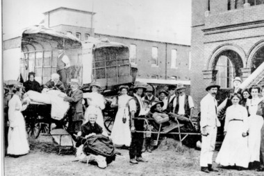
 City of Moorabbin Historical Society (Operating the Box Cottage Museum)
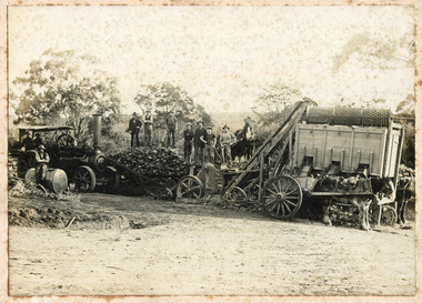
Photograph - Photograph, 1908 Excavation commences for the Melbourne Benevolent Society, Cheltenham, 1908 Excavation commences for the Melbourne Benevolent Society, Cheltenham, 1908
... Society in Cheltenham. The Centre had begun life in 1850... was located to a new site at Warrigal Road, Cheltenham. The foundation ...Excavating prior to the building of Melbourne Benevolent Society in Cheltenham. The Centre had begun life in 1850 in Melbourne, as the Victoria Benevolent Asylum to "relieve the aged, infirm, disabled and destitute poor of all creeds and nations and to minister to them the comfort of religion" It outgrew its North Melbourne premises so was located to a new site at Warrigal Road, Cheltenham. The foundation stone was laid in 1909, and the main buildings were completed in 1911. In 1970 the benevolent Asylum was re-named Kingston Centre. The photograph is black and white. It's a photo depicting the excavation prior to the building of Melbourne Benevolent Society in Cheltenham. The photograph shows eleven workers at the excavation site. There are two horses with carriages and a large excavating machine to the right of the photograph. benevolent asylum, benevolent society, cheltenham, train, machinery, men, society, horses, kingston centre -
 City of Moorabbin Historical Society (Operating the Box Cottage Museum)
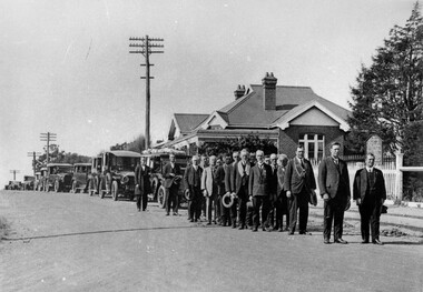
Photograph - Photograph, G.T Allnutt leading off the 1916 Easter Carnival, G.T Allnutt leading off the 1916 Easter Carnival, c1900
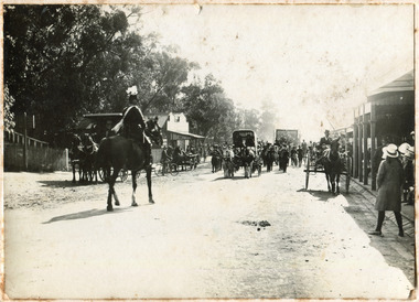
... Charman Road, from the Cheltenham Temperance Hall, where... horse along the Charman road from Cheltenham on the left... road parade cheltenham horses Photo mount ; Charman Rd Early ...This photograph is of the 1916 Easter Carnival. G.T. Allnutt, in uniform, and on horseback, is leading the parade down Charman Road, from the Cheltenham Temperance Hall, where the parade commenced, to the Mentone Recreation Ground.A black and white photograph. G.T Allnutt is riding on his horse along the Charman road from Cheltenham on the left of this photograph. There are several people along the Charman road with also 5 horse carriages and a marching band. You can see in this photograph that there are a few shops on either side of the road, such as a shop called Tobacconist, which is on the left. Photo mount ; Charman Rd Early 1900 / Cheltenham 1916, easter carnival, g.t. allnutt, horseback, temperance hall, mentone, mentone recreation ground, charman road, parade, cheltenham, horses -
City of Kingston
Photograph - Black and white, 3 March 1954
... left); Bay Road, Cheltenham (bottom right), Friendship Square...); Keys Road Moorabbin (bottom left); Bay Road, Cheltenham (bottom ...Cheltenham and Moorabbin are suburbs within the City of Kingston that were originally established as rural market gardening communities The area is bordered by Highett and Mentone. The market gardens, farms and paddocks have gradually been sub-divided into housing and industrial estates. Highett is developed with residential homes but was also the site of major facilities such as the Highett Gas Works. This aerial image covers a diverse section of the City of Kingston, taking in the suburbs of Moorabbin, Cheltenham, Highett and Mentone Residential housing development is prominent along the Frankston Railway line and the area still retains extensive market gardens and paddocks yet to be converted to a large industrial and commercial zone.Aerial photograph of Mentone, Cheltenham and Moorabbin within the City of Kingston. The area depicted in this 1954 aerial view includes Warrigal Road and Centre Dandenong Road intersection (top left); Charman Road, Patty Street, Bourke Street, Collins Street Mentone (top right); Keys Road Moorabbin (bottom left); Bay Road, Cheltenham (bottom right), Friendship Square, Cheltenham Park, Victoria Golf Club and Jack Barker Oval are visible. Nepean Highway and the Frankston railway line run centrally through the image. Highett Gasworks is also evident.White handwriting and type [indecipherable]. White image of clockface White image of compass White type 42956 Black handwriting 3/3/54 Williams [indecipherable] Black pencil: S [arrow] Black ink: 3/3/1954cheltenham, moorabbin, mentone, highett, market gardens -
City of Kingston
Photograph - Black and white, 5 January 1984
... aerial view includes Centre Dandenong Road and Cheltenham East... Dandenong Road and Cheltenham East Primary School (top left ...Cheltenham and Heatherton are suburbs in the City of Kingston that were originally established as a rural market gardening community. The market gardens, farms and paddocks have gradually been sub-divided into housing and industrial estates and associated infrastructure such as schools and shopping facilities. This aerial image covers a diverse section of the City of Kingston, taking in the suburbs of Cheltenham, Heatherton, Mentone and Parkdale. By 1984, the market gardens of the district have been replaced by housing and factories. The Nylex factory is visible and now closed. Mentone Bowl on the corner of Warrigal Road and Nepean Highway has now been replaced by high rise apartments, another feature of the changing landscape in the City of Kingston. The vacant land now occupied by the Moorabbin Airport Direct factory Outlet (DFO) is also depicted.Aerial photograph of Cheltenham, Heatherton, Mentone and Parkdale within the City of Kingston. The area depicted in the 1984 aerial view includes Centre Dandenong Road and Cheltenham East Primary School (top left), Kingston Heath Reserve (top right), intersection of Lower Dandenong Road, Warrigal Road, Balcombe Road and Nepean Highway (bottom left), Balmoral Drive/McSwain Street Parkdale (bottom right).White text: 3831-179 Lens information [indecipherable] RINGWOOD M/S 7922-3 RUN 16 [Clockface image] 5,300' ASL VIC DLS© 5-1-84cheltenham, heatherton, mentone, parkdale, market gardens, urbanisation -
 City of Kingston
Photograph - Black and white, c. 1908
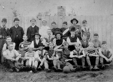
... and Charman roads in Cheltenham. In 1907 the Cheltenham progress... and Charman roads in Cheltenham. In 1907 the Cheltenham progress ...Australian rules football began being played on a regular basis in Cheltenham in 1890. Teams would not only play locally but travel by train fairly long distances, such as to Ballarat, for the day, play a game, turn around and come home. The Cheltenham home games were played on a paddock on the corner of Park and Charman roads in Cheltenham. In 1907 the Cheltenham progress committee made an application to the board of land works for land in Weatherall Road for recreational service to the public. That application was received and granted, then developed where Cheltenham Recreational Reserve now stands. The ground was opened in 1909 and the first Cheltenham side entered in the newly formed Federal Football League along with seven other foundation members, Mordialloc, Mentone, Moorabbin, Frankston, Glenhuntly, Elsternwick, and Ellindale. The grand final for that year, 1909 was a hard encounter between Cheltenham and Ellindale with Cheltenham coming out victors, thus becoming the inaugural Federal Football League premiers. The Federal Football League (FFL), also known simply as the Federal League, was an Australian rules football competition in the south-eastern suburbs of Melbourne, Victoria. The competition was in existence from 1909 to 1981 and was regarded as one of the strongest metropolitan leagues in Melbourne.Black and white image of the players and officials of the Cheltenham Football Club. Back (left to right) G Puttick, Franklyn (sic), Unkown, Unknown, C Corstorphine, D Arland, Dave Hughes, H Bryant, Centre: T Elliott, S Parsons, F Judd, H Foreman, N Corstorphine, J McCormack, S Chandler, H Orr. Front: H Clayton - no other names recorded. The players are wearing what appears to be a range of club jumpers, with some in street wear. Some players seated in the front row have mud visible on the soles of their shoes, indicating they may have already played a gam. The ball on the ground in front of the group is round.Round red sticker on reverse with handwritten text: X10 Handwritten in blue ink: A11, with a circle around it Handwritten in red ink: 50%sport, football, cheltenham, teams, federal football league -
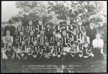 City of Moorabbin Historical Society (Operating the Box Cottage Museum)
Photographs, x 3 Black & White Cheltenham Football Club 1909,1913, 1946, 20thC
... and Charman roads in Cheltenham. In 1907 the Cheltenham progress... and Charman roads in Cheltenham. In 1907 the Cheltenham progress ...Known as the Rosellas, the early Cheltenham Football Club sides began playing on a regular basis in 1890, and would travel long distances by steam train to play country teams, such as Ballarat where they would arrive at their destination, play the match, socialize then return to the station. Opposition players and supporters would give three hearty cheers on their departure. The Cheltenham home games were played on a paddock on the corner of Park and Charman roads in Cheltenham. In 1907 the Cheltenham progress committee made an application to the board of land works for land in Weatherall Road for recreational service to the public. That application was received and granted, then developed where Cheltenham Recreational Reserve now stands. The land in the early days was virgin bush and the response for voluntary help to clear the area was outstanding. Nearly all the market gardeners in the district along with horses, ploughs, axes, shovels completely cleared the area in three weeks. The Moorabbin council then leveled the playing area and erected a post and rail fence around the ground. Pine tree shrubs were then planted on the west side of the ground. The ground was opened in 1909 and the first Cheltenham side entered in the newly formed Federal Football Association along with seven other foundation members, Mordialloc, Mentone, Moorabbin, Frankston, Glenhuntly, Elsternwick, and Ellindale. The grand final for that year, 1909 was a hard encounter between Cheltenham and Ellindale with Cheltenham coming out victors, thus becoming the inaugural Federal Football Association premiers. Cheltenham went onto win five senior premierships in the Federal Football Association by the end of the 1920s, they won the flags in 1909, 1911, 1913, 1922 and 1925, with the late Percy Woff playing in all 5 premiership sides and was captain in 1922. 1928 saw the start of an outstanding career from our oldest living player Tom Connor. Cheltenham continued to win premierships in the 1920’s and 1930’s with juniors taking out the 1929 and 1933 flags, under the guidance of Woff, and that continued in 1934 when Cheltenham took out the 1st XVIII and 2nd XVIII premierships. Cheltenham produced its only Brownlow medallist in Peter Box who played in the late 1940s, before going to Footscray where he became a champion. The 3rd XVIII went through the season undefeated in 1974 winning the premiership, with Trevor Barker a key player before going to St Kilda the following year. The club won three senior premierships under coach Barry White in 1992, 1993 and 1995. ( from CFNC website 2019) Cheltenham Football Club was formed 1890 and succeeded in winning many Premierships as a member of the Federal Football Association, Outstanding players Peter Box Brownlow Medalist 1956 Footscay VFL, , Trevor Barker and Kevin Roberts St Kilda VFL.3x Black & White photographs of the players in the Australian Rules Cheltenham Football Club 1909, 1913 and 1946 extra photo of Peter Box Folio 10 MAV 01059a) CHELTENHAM FOOTBALL CLUB 1909 Cheltenham Football Club 1909. Back row: A Chandler, committee member; R. Robertson, back-pocket; J. Harris, half back flank; J Adams, ruck and forward-pocked; M. J. Monk, club president; L. Woff, back-pocket; W. Adams, ruck and back-pocket; P. Woff, rover and forward-pocket; A Monk, committee member. Middle row: W. Hore, back pocket and ruck; A. Towns, half-forward flank; W. Carson, full back; F. Andrews, captain-half forward flank; H. Butler, centre half back; J. Warburton, centre half-forward; A. Slater, half-back flank; F. Fisher, half-forward flank; C. Sherwood, trainer. Front Row: G Gouldthorpe, wing; H. King, full-forward; W. Johnston, ruck and forward-pocket; P Spears, rover and forward-pocket; F. Bichl, wing; A. Bichl. rover and forward-pocket; F. Butler, centre player. Courtesy, Lionel Seal. ( from CFC website 2019) b) CHELTENHAM 1913 PREMIERS c) CHELTENHAM -1946 / Back row - J. Fisher, G.Corrigan, N.Hocking, F.Virtue, R.Craven, L.Baker, M.Blundell / 2nd Row - J.Phillips, T.Connor, E.Hawkins, A.Blakely, G.Baker, A.Dark, J.Barker, D.Craven, J.Pickering, P.Cameron,/ W.Hicks, G.Hoskings, R.Beihl, A.Hubbard, R.Kier, C.Russell. / Front Row - Clark Taylor, J.Slade, N.Niel, J.Brooks, T,Butler, H.Hosking, C.Hacusler, E.Hornibrook, W.Briggs, B.Russell, L.Biehl, / W Ripponcheltenham football club, australian rules football, victorian football association, victorian football league, smith j l; smith mary ann, stanley helen, , chaff cutter, horse drawn carts, toll gates brighton, motor cars 1900, steam engines, early settlers, bentleigh, parish of moorabbin, city of moorabbin, county of bourke, moorabbin roads board, shire of moorabbin, henry dendy's special survey 1841, were j.b.; bent thomas, o'shannassy john, king richard, charman stephen, highett william, ormond francis, maynard dennis, market gardeners, vineyards, orchards, cheltenham, two acre village, holloway josiah,, woff percy, connor tom, box peter, barker trevor, white barry, browlow charles, -
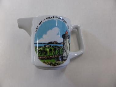 Warrnambool and District Historical Society Inc.
Jug, 'Lady Bay' transfer, 1960s
This is a souvenir jug made for the local tourist trade in the 1960s. The jug has an image of Lady Bay, Warrnambool. The official name of Lady Bay is Warrnambool Bay. The jug was made by Westminster Fine China Australia, a firm established in 1954 by the cutlery and silverware firm of Stanley Rogers and Sons of Melbourne. Westminster China was fist established in Cheltenham in Melbourne and after 1977 it was operating in Sandringham, Victoria. It was still operating in the 1990s and produced mainly souvenir and giftware. This jug is retained because it is a good example of the souvenir items offered to local tourists in the 1960s. This is a small white china jug with a gold strip down the handle and a gold rim around the opening and the lip. On the side of the jug is a multi-coloured image of the lower lighthouse and Lady Bay, Warrnambool. The maker’s name is on the base of the jug. ‘Lady Bay Warrnambool Vic.’ ‘Fine China Westminster Australia’ warrnambool bay, westminster china, australia, tourism in warrnambool -
Warrnambool and District Historical Society Inc.
Plate, City of Warrnambool, Late 20th century
This plate would have been part of a crockery set used by the Warrnambool City Council at civic functions and receptions. It probably dates from the late 20th century. It was made by Westminster China which was a business established by Stanley Rogers and Sons Limited in Cheltenham, Melbourne in 1954. In 1977 the business was moved to Sandringham, Melbourne and by the 1990s it was mainly producing items for the hospitality sector. Warrnambool became a Municipality in 1865, a Borough in 1863, a Town in 1883 and a City in 1918. The seal and motto, ‘By These We Flourish’ were designed and drafted by John Macdonald, an original member of the Municipal Council in 1856 and the first Head Master of Warrnambool’s National School in 1850. This plate is of interest as one of a set used by the Warrnambool City Council in the late 20th century. This is a white china plate, slightly bowl-shaped, with a gold strip around the rim. The gold is partly fading. The plate has the City of Warrnambool crest in blue and yellow on one outer edge of the plate. ‘City of Warrnambool Victoria’ ‘By These We Flourish’ warrnambool city council, history of warrnambool -
Frankston RSL Sub Branch
Certificate, Young Workers' Patriotic Guild
Printed certificate awarded by the Education Department, Victoria to schoolchildren who raised the amount of one pound (the currency of that time) for the War Relief effort during World War 2. This example bears the name of Eva Littlechild, a pupil at Cheltenham School number 84 and is dated 22nd December, 1942. The certificate is signed by A E Lind, Minister of Education, J A Seitz, Director of the Education Department and H G Bretherton, Headmaster of the school. This ornate certificate is printed in colour on a medium quality card with handwritten awardee details.refer image -
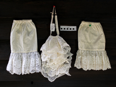 City of Moorabbin Historical Society (Operating the Box Cottage Museum)
Ceremonial object - Clothing, 'Jabot' style collar and cuffs Moorabbin City Council Mayoral Robes, c1960
In clothing, a collar is the part of a shirt, dress, coat or blouse that fastens around or frames the neck and may be permanently attached to the main body of the garment (e.g. by stitching) or detachable. Today's shirt collars descend from the ruffle created by the drawstring at the neck of the medieval chemise, through the Elizabethan ruff and its successors, the whisk collar and falling band. Separate collars exist alongside attached collars since the mid-16th century, usually to allow starching and other fine finishing. Jabots made of lace and hanging loose from the neck were an essential component of upper class, male fashion in the baroque period. During the Edwardian period, and sporadically thereafter, ornamental collars were worn as a form of jewellery. Names for specific styles of collars vary with the vagaries of fashion. Jabots survive in the present days as components of various official costumes, as are those worn by judges and counsel throughout Australian courts and town mayors. 2018 Kingston City Council Mayor Steve Staikos asked CMHS to loan the Former Moorabbin Mayoral Robes and Jabot for display at KCC Office Cheltenham. These Moorabbin Mayoral Robe with Jabot are now displayed along with those of the former City of Chelsea Robe and the former City of Mordialloc Robe at Cheltenham . KCC possesses the original Mayoral Chains of each former Council and they are displayed on each Robe for the annual Opening Meeting of KCC in February. This set of a 'Jabot' style collar and cuffs was part of the ceremonial Mayoral Robes c1960- 94 for the City of Moorabbin 1934-94. This is the last City of Moorabbin Mayoral Robe and was worn by Mayor Ron Brownlees, (prior to amalgamation with the City of Glen Eira and City of Kingston in 1994), and donated to the City of Moorabbin Historical Society in February 2007 by the City of Kingston. The City of Moorabbin developed from the Moorabbin Roads Board of 1862, becoming The Shire of Moorabbin in 1871 and the City of Moorabbin in 1934. November 2018 At the request of the Mayor Cr Steve Staikos this Jabot Collar and Cuffs is now on display with the Mayoral Robes at Kingston City Council Offices Nepean Highway Cheltenham . A detachable , white, nylon, 'Jabot' style, standing collar with a pleated, ruffled, and lace-trimmed frill down the front and 2 matching cuffs that was part of the City of Moorabbin Mayoral Robes c1960 - 94 It has a tear in corner. clothing, collars, ornamental collars, civic robes, mayoral robes, moorabbin, cheltenham, bentleigh, lacework, dressmaking, fashion, formal wear, city of moorabbin. moorabbin shire, moorabbin roads board, brownlees ron, city of glen eira, city of ikngston -
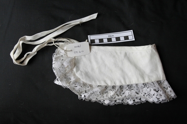 City of Moorabbin Historical Society (Operating the Box Cottage Museum)
Clothing - Clothing, lady's cotton collar, c1960
A collar is the part of a shirt, dress, coat or blouse that fastens around or frames the neck and may be permanently attached to the main body of the garment (e.g. by stitching) or detachable. Names for specific styles of collars vary with the vagaries of fashion. A lady's detachable, white, cotton collar with machine lace edge and long ties c1960clothing, collars, ornamental collars, moorabbin, cheltenham, bentleigh, lacework, dressmaking, fashion, formal wear, shawl collar