Showing 1709 items
matching counties
-
 Whitehorse Historical Society Inc.
Map, Directory Maps of the County of Bourke, 1892
Directory maps of the County of Bourke, containing all the Parishes ...Directory maps of the County of Bourke, containing all the Parishes ... also a complete map of the Colony of Victoria, showing all the Counties, Parishes, Railways and stations to date, and the Mallee Blocks. Lithographed by G.S.B. Bonney for the Victorian Shire Map Company. Scale: 40 chains to the inch.Directory maps of the County of Bourke, containing all the Parishes ...maps, victoria. county of bourke, t.r.b. morton & son -
Whitehorse Historical Society Inc.
Map, Parish of Nunawading, 1939
Plan of subdivision part of crown portions 81, 82 and 89,Plan of subdivision part of crown portions 81, 82 and 89, Parish of Nunawading, County of Bourke, Blackburn Wellington Avenue amended from Stanley RoadPlan of subdivision part of crown portions 81, 82 and 89, street names, parish of nunawading, blackburn road, blackburn, wellington avenue, blackburn, wolseley crescent, blackburn, gordon crescent, blackburn, clarke street, blackburn, central road, blackburn -
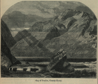 Ballarat and District Irish Association
Image, Gap of Dunloe, County Kerry, c1864
The Gap of Dunloe is a narrow mountain pass between Macgillycuddy's Reeks (west) and Purple Mountain (east) in County Kerry, Ireland. It is about 11 km (6.8 mi) from north to south. Within it are five lakes: Coosaun Lough, Black Lake, Cushnavally Lake, Auger Lake, and Black Lough (north to south). These lakes are connected by the River Loe. Between the first two lakes is an old arch bridge called the 'Wishing Bridge' so named because it is said that wishes made while upon it are destined to come true. (http://en.wikipedia.org/wiki/Gap_of_Dunloe)Image of a mountain range in County Kerry, Ireland. Cattle feature in the foreground. ballarat irish, dunloe, gap of dunloe, county kerry -
 Otway Districts Historical Society
Document, Instructions to Bailiffs of the County Court, 1978, 1 January 1978
Bailiffs are officers of the Court and as such play an important role in the overall administration of justice. This booklet has been prepared as a guide to Bailiffs of the County Court of Victoria in the performance of their duties. The principal functions of the Bailiffs are the issue and service of summonses, and verdicts and judgements given effect by the execution of warrants. In any case where Bailiffs are uncertain or unsure of what to do the Registrar of the Court to which they are attached should be consulted and their directions followed.Document. Instructions to Bailiffs of the County Court. State of Victorian; Melbourne (Vic); 1978. 28 p. Soft cover.victoria; bailiffs; county court; -
 Flagstaff Hill Maritime Museum and Village
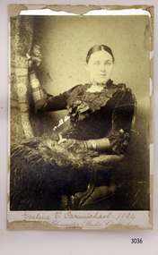
Photograph, late 1800's
Miss Eva Carmichael is one of two survivors of the Loch Ard shipwreck.. Loch Ard was bound for Melbourne in 1878 loaded with passengers and cargo when it ran into a rocky reef at the base of Mutton Bird Island, near Port Campbell. Of the 54 crew members and passengers on board, only two survived: an apprentice, Tom Pearce and a young woman passenger, Eva Carmichael, who lost all of her family in the tragedy. The wreck of Loch Ard still lies at the base of Mutton Bird Island and much of the cargo has been salvaged. Some was washed up into what is now known as Loch Ard Gorge following the shipwreck. Cargo and artefacts have also been illegally salvaged over many years before protective legislation was introduced. The photograph is significant for its association with the wreck of the Loch Ard. This wreck has been protected as a Historic Shipwreck since 11 March 1982, under the Commonwealth Historic Shipwrecks Act (1976) Flagstaff Hill’s collection of artefacts from Loch Ard is significant for being one of the largest collections of artefacts from this shipwreck in Victoria. It is significant for its association with the shipwreck, which is on the Victorian Heritage Register. The collection is significant because of the relationship between the objects, as together they have a high potential to interpret the story of the Loch Ard. The Loch Ard collection is archaeologically significant as the remains of a large international passenger and cargo ship. The Loch Ard collection is historically significant for representing aspects of Victoria’s shipping history and its potential to interpret sub-theme 1.5 of Victoria’s Framework of Historical Themes (living with natural processes). The collection is also historically significant for its association with the Loch Ard, which was one of the worst and best known shipwrecks in Victoria’s history. The Loch Ard collection meets the following criteria for assessment: Criterion A: Importance to the course, or pattern, of Victoria’s cultural history. Criterion B: Possession of uncommon, rare or endangered aspects of Victoria’s cultural history. Criterion C: Potential to yield information that will contribute to an understanding of Victoria’s cultural history. Photograph of Miss Eva Carmichael sitting on a chair holding a curtain. Text below photograph is partly unreadable but gives the name of the photographic studio. A printed on the back "County of Gloucester Studio Cheltenham" with the address and other informaion.Reverse has crest that includes “PRIZE MEDALIST PARIS EXHIBIT’N 1867” Printed text “No. …………” “COUNTY OF GLOUCESTER STUDIO / 20a / PROMENADE VILLAS / CHELTENHAM” and “Autotype Prints or Permanent Porcelain enlargements can be made from this plate” flagstaff hill, warrnambool, shipwrecked-coast, flagstaff-hill, flagstaff-hill-maritime-museum, maritime-museum, shipwreck-coast, flagstaff-hill-maritime-village, photograph of miss eva carmichael, eva carmichael, loch ard shipwreck, county of gloucester studio -
 Lakes Entrance Historical Society
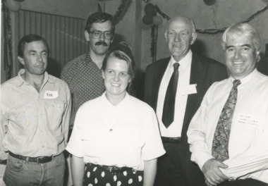
Photograph - East Gippsland Shire with Tourism Lakes Entrance Victoria, Lakes Post Newspaper, 1/12/1994 12:00:00 AM
tourism operators Rob Coates and Damien Waters Bruce Evans and Nicole Leader of East Gippsland Shire with Ken Hore of County Victoria Tourism Lakes Entrance VictoriaBlack and white photograph showing tourism operators Rob Coates and Damien Waters Bruce Evans and Nicole Leader of East Gippsland Shire with Ken Hore of County Victoria Tourism Lakes Entrance Victoriatourism, east gippsland shire -
 Lakes Entrance Historical Society
Photograph - County Antrim, c1940
County Antrim was wrecked off coast of Lakes Entrance Victoria 12 January 1897 Later moved to Port AlbertBlack and white photograph of the figurehead from the County Antrim wrecked off coast, shows wooden figurehead in garden of Kalimna Hotel, where it had been placed as a garden feature soon after the wreck was abandoned. Lakes Entrance Victoriaships and shipping, shipwrecks, hotels -
 Warrnambool and District Historical Society Inc.
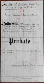
Document - William J Osborne Probate 1900Document, 1900
Tait collection: item 48 of 62 This is a document giving details of the Will and Probate of William James Osborne, a Tallangatta farmer who died in 1896 at the age of 59. His death place is given as Tower Hill. A William Osborne is listed as a Wangoom farmer in 1856, a farmer at ‘Thompson’s Old Farm’ in Allansford in 1866 and a farmer at Winton Farm on the Allansford Road near Shipley in 1869 but these references may be to William Osborne’s father as there is mention of a William Osborne, Junior at that time. William James Osborne left real estate to the value of £560 and personal estate to the value of £81 to his wife, Hannah. The lawyer who drew up this document was Ernest Chambers who had legal offices in Warrnambool, Koroit and Port Fairy at the end of the 19th century and the beginning of the 20th century. He was in possession of this document and it has passed down to successive lawyers occupying the legal premises in Kepler Street where it was located in 2014 (former premises of the law firm of Mackay Taylor). This document is of interest as it gives details of the Will and Probate of William James Osborne, a farmer in the Allansford area in the 19th century. This is a cream-coloured piece of parchment paper folded in two to make four pages. Three of the pages have handwritten material in brown ink and the pages are not ruled. A seal of the Supreme Court of Victoria is attached with a green ribbon and there is one red stamp of the Master in Equity of the Supreme Court. The document is somewhat stained but legible. The document gives details of the Will and Probate of William Osborne of Tallangatta in the County of Heytesbury. He died in 1896. In the Supreme Court of the Colony of Victoria in the Probate Jurisdiction in the Will of William James Osborne late of Tallangatta in the County of Heytesbury in the Colony of Victoria Farmer deceased. ernest chambers, warrnambool lawyer, william james osborne, tallangatta, tait collection -
Whitehorse Historical Society Inc.
Document, Certificate of Title, 1922, 1933
Certificate of Title, Margaret Kennedy.Certificate of Title, Margaret Kennedy. Lots 100, 101 & 102, subdivision 1968, part of crown allotment 1270, Parish of Nunawading, County of Bourke 1922 vol 4583, fol 916577 also rates enforcement of charge, 1933.Certificate of Title, Margaret Kennedy.land titles, shire of blackburn and mitcham, kennedy, margaret, mcdowall street, mitcham -
 Ballan Shire Historical Society
Map - Map. Kerrit Bareet, Department of Lands and Survey, Kerrit Bareet. County of Grant, 08/1944
A map of the Kerrit Bareet area within the County of Grant showing properties and names of owners in 1944.Significant to people researching land usage and ownership. Also those researching families in the area at that time.A map of Kerrit Bareet in the County of Grant. Black printing on buff coloured paper. Details roads, rivers, railways, property boundaries and names of property owners and towns and villages. The map is easily readable although there is some physical damage and that and the borders have been reinforced with sellotape. Shows a Scale in Chains and Price 2/.gordon, bungal, kerrit bareet, lal lal, moorarbool river, warrenheip, bungaree, wallace, moorarbool west -
Whitehorse Historical Society Inc.
Document, Certificate of Title, 1915, 1933
Certificate of Title, Frederick William GibbonsCertificate of Title, Frederick William Gibbons, Lot 88, Subdivision 1968, part of crown allotment 1270, Parish of Nunawading, County of Bourke 1915. Vol 3882, fol 776385 also correspondence re rates, enforcement of charge, 1933.Certificate of Title, Frederick William Gibbonsland titles, shire of blackburn and mitcham, gibbons, frederick william, shire of nunawading, burnett street, mitcham, gort road, mitcham -
 Warrnambool and District Historical Society Inc.
Documents Maps (3) - Warrnambool Town Allotments, City of W'bool Parish of Wangoom Country of Villiers, 1948
These maps were produced in 1948 and they contain maps of allotments within the city of Warrnambool, including the Central Business District, up to 1948. The details given on each allotment show the allotment and section numbers, the measurement in acres, the name of the original purchaser of the lot and the date of the first sale. The Warrnambool and District Historical Society owns several copies of these maps but these ones are originals.These three maps are of great significance because they give the names of land purchasers in Warrnambool from the date of the first land sales in 1847. They are a most valuable research tool and can be scanned and photocopied etc.These are three sheets of cream paper pasted on to linen. The sheets have black and white printing and map work. Some of the edges are a little frayed and there is some staining, particularly on the backs of the sheets.‘City of Warrnambool Parish of Wangoom County of Villiers Sheet 1’ ‘City of Warrnambool Parish of Wangoom County of Villiers Sheet 2’ ‘City of Warrnambool Parish of Wangoom County of Villiers Sheet 3’city of warrnambool, warrnambool maps, warrnambool town allotments 1948, land purchases -
Whitehorse Historical Society Inc.
Map, Parish of Nunawading, 1853
Photocopy of manuscript map with allotments numbered and named.Photocopy of manuscript map with allotments numbered and named. Note on verso: Parish of Nunawading, County of Bourke. Gardiners Creek, Ballyshanassey Township, surveyed by H. Parmein, Surveyor General's office, Nov 30th 1853 [enlargement of ND2801, no list of corner references]Photocopy of manuscript map with allotments numbered and named. maps, gardiners creek, ballyshanassy, burwood east, parmein, h -
Stawell Historical Society Inc
Map, County of Ripon, 1858
County of Riponstawell -
Whitehorse Historical Society Inc.
Map, The Parish of Nunawading, 1853
Photocopy of manuscript plan with allotments numbered and some named.Photocopy of manuscript plan with allotments numbered and some named. Note on verso: The Parish of Nunawading in the County of Bourke; lithographed at the Surveyor General's office by J.Jones Jan 18th 1853. Endorsed Sale Plan 271. Dray tracks, water holes and terrain indicated.Photocopy of manuscript plan with allotments numbered and some named. land subdivision, maps, parish of nunawading, jones, j -
 Warrnambool and District Historical Society Inc.
Map, Department of Lands and Survey (Lithographers), Caramut township, 1938
This map of the township of Caramut was produced in 1938 but shows the original land owners of each town allotment and of the surrounding area. The size of all the allotments and the date of the original purchase are also shown. Caramut is a Victorian Western District town on Mustons Creek on the Hamilton Highway 48 kilometres from Warrnambool. This map was used by Rolf Crawley when he was the engineer for the Shire of Warrnambool from 1935 to 1968. The annotations on the map have probably been made by Rolf Crawley as they refer to the records and letter books of his father, John William Crawley, Junior (Shire of Warrnambool Engineer 1895 to 1935). Both Rolf Crawley and his father, John had private businesses as architects, surveyors and engineers and the map could have been used in connection with both their official Shire duties and their private businesses. The last owner of the map was the surveyor, Michael Hand who took over the business of Rolf Crawley in the late 1960s. This map is of great interest firstly because it has all the historical details of the land first purchased in the town of Caramut and area and secondly because it came from the office of Rolf Crawley, the engineer for the Shire of Warrnambool from 1935 to 1968. This is a buff-coloured paper map with a cloth backing. The map details are in black and white print. There are some handwritten red and black annotations on the map. “Town of Caramut Parish of Caramut County of Villiers’town of caramut, john william crawley junior, warrnambool, rolf crawley, warrnambool -
Stawell Historical Society Inc
Map - Subdivision map, Subdivision of North Woodlands Estate Map
Shows Homestead Cottage and Dam, Plus Shed. Malakoff NavarreA3 photocopy of MapParishes of Malakoff and Navarre. County of Kara karasurvey -
Whitehorse Historical Society Inc.
Document, Certificate of Title, 1921, 1933
Certificate of Title, Charles Norris and William Richard Norris.Certificate of Title, Charles Norris and William Richard Norris. Lot 6 Subdivision 4894, part of crown portions 89 & 90, Parish of Nunawading, County of Bourke 1922. Vol 4474, fol 894734 also correspondence re rates, enforcement of charge 1933.Certificate of Title, Charles Norris and William Richard Norris.land titles, shire of blackburn and mitcham, norris, charles, norris, william richard, blackburn road, blackburn -
 Ballan Shire Historical Society
Map - Map. Ballark, Department of Lands and Survey, Ballark. County of Grant, 31/08/1915
A map of the Ballark area within the County of Grant showing roads, waterways, property boundaries and property owners in 1915.Significant to people researching land usage and ownership. Also those researching families in the area at that time.A map of Ballark in the County of Grant. Black printing on buff coloured paper. Extra notations by hand and various coloured highlighting of certain features. Details roads, rivers, property boundaries and names of property owners and districts. The map is easily readable although there is some physical damage to the borders and some sellotape residue. Shows a scale in Chains and the number L.6030Various numbers and directional arrows added to map.bungal, borhoneyghurk, bungeeltap, ballark, beremboke, moreep, meredith, morrisons, moorarbool river -
 Bendigo Historical Society Inc.
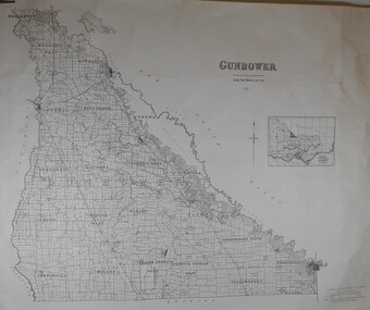
Map - JACK FLYNN COLLECTION: GUNBOWER, 1935
Map: County of Gunbower, map sheet showing the whole of the County of Gunbower and all of the Parishes within.map, gunbower, county, gunbower -
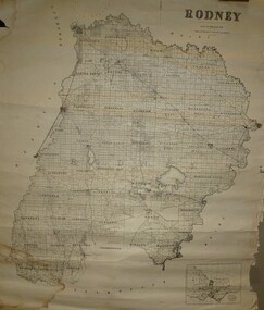 Bendigo Historical Society Inc.
Map - JACK FLYNN COLLECTION: RODNEY, Revised in 1935
Map: County of Rodney, map sheet showing the whole of the County of Rodney and all of the Parishes within.Drawn at the Department of Lands and Survey, Melbourne. Revised to 1935map, rodney, parish plan, rodney -
Stawell Historical Society Inc
Map, Gampola, County of Borung, 1957
Gampola, County of Borungstawell -
Stawell Historical Society Inc
Map, Bellaura, County of Borung, 1880
Bellaura, County of Borungstawell -
Stawell Historical Society Inc
Map, Bellaura, County of Borung, 1924
Bellaura, County of Borungstawell -
Stawell Historical Society Inc
Map, Bellellen, County of Borung, 1952
Bellellen, County of Borungstawell -
Stawell Historical Society Inc
Map, Boroka, County of Borung, 1958
Boroka, County of Borung stawell -
Stawell Historical Society Inc
Map, Concongella, County of Borung, 1929
Concongella, County of Borungstawell -
Stawell Historical Society Inc
Map, Gampola, County of Borung, 1957
Gampola, County of Borungstawell -
Stawell Historical Society Inc
Map, Glenorchy, County of Borung, 1956
Glenorchy, County of Borungstawell -
Stawell Historical Society Inc
Map, Illawarra, County of Borung, 1882
Illawarra, County of Borungstawell