Showing 291 items
matching early farming
-
 Orbost & District Historical Society
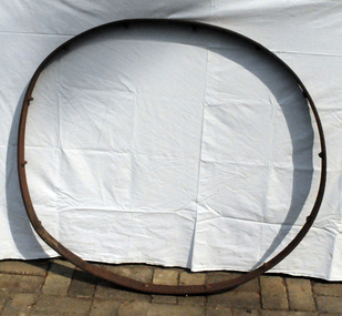
wagon wheel rim, mid 19th century -mid 20th century
... farming property. This item is an example of early farming ...Could have been from a hay rake and used on a local farming property.This item is an example of early farming machinery used in the Orb ost district.Rim of an iron wheel. Possibly from agricultural machinery. The 13 spokes have been cut off.iron wheel-rim agricultural-machinery -
 Orbost & District Historical Society
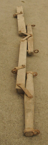
farm implement
... on the Orbost district. This item is an example of an early farming ...This is a very common 'farm' style of old swinglebar. Blacksmiths and agricultural machinery suppliers made them by the thousands. They were used most commonly on heavy vehicles pulled by horses. This one would have been used on a farming property on the Orbost district.This item is an example of an early farming implement used in the Orbost district. It also demonstrates the improvisation skills of the agricultural community.Four pieces of wood connected by iron fittings. Two pieces have iron loops at both ends. The two straight pieces appear to be newer. There are two swingle trees. It appears to be a 2-horse set of swinglebars with a double-bar. which has been added to and repaired.agricultural-implement horses farming swinglebar -
 Orbost & District Historical Society
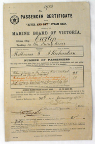
certificate, 30th January 1903
This certificate was issued on January 30, 1903 to Captain Alan Richardson by the Marine Board of Victoria entitling her to carry 25 passengers and only 10 passengers when engaged in towage service. Two children under 12 years of age to be reckoned as one passenger. The penalty of 20 pounds would be levied if these limits were exceeded. the certificate was valid until 21st July 1903. The original Paddle Steamer Curlip was built by Sam Richardson and his sons Mark, Albert and Frank, at their sawmill at Tabbara, a pioneering settlement on the Brodribb River, a tributary of the Snowy River. Curlip's keel was laid on 14th October 1889 and PS Curlip was launched in 1890. The Paddle Steamer Curlip was designed to travel up and down the Snowy and Brodribb Rivers with essential supplies from coastal ketches and schooners, that plied their trade up and down the coast between Melbourne, Sydney and Tasmania. The Curlip regularly towed one or two barges and up to five barges loaded with local farming produce and timber for the thriving cities, that was loaded offshore or in the Snowy River estuary, tide and depth permitting, on to the trading vessels.This item is associated with the P.S. Curlip and the Richardson family, early Orbost pioneers.A paper passenger certificate for a river steam ship.Details are handwritten in black and red ink.curlip-p.s. certificate-passenger richardson -
 Orbost & District Historical Society
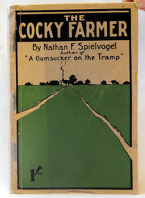
book, The Cocky Farmer, 1907
Nathan Frederick Spielvogel (1874-1956), teacher, writer and historian, was born on 10 May 1874 at Ballarat, Victoria. as well as his stories he published a number of Books about the history of Ballarat. Nathan Frederick Spielvogel (1874–1956) was a teacher, writer and historian. As a country schoolteacher, he traveled widely in the eastern Australian outback and also made a journey to London. Spielvogel gained distinction as one of the only Australian Jewish writers of his time. Many of his early books were best-sellers. A paper back book with 146 pp.written by Nathan Spielvogel. On the front cover is a drawing of a farm-house in a green paddock. The book is about school life and farming at Sale, Stawell, and the Wimmera district. the-cocky-farmer spielvogel-nathan literature -
 Orbost & District Historical Society
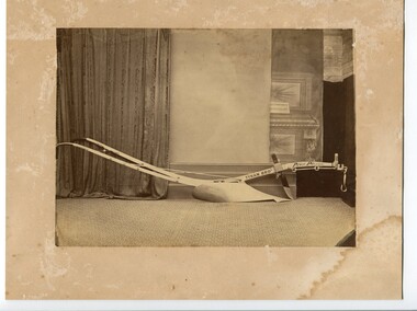
black and white photograph
... . This is a photograph of an early farming tool. photograph-plough-tynan ...There is no information with this item. John Tynan's Victoria Agricultural Implement Factory began making ploughs in 1857. His company is also believed to be the first to have produced drilling tools suitable for use in basalt quartz-load gold mining. Tynan was the first person to manufacture swing ploughs. His ploughs won numerous prizes, including the first gold medal ever given in Victoria for a colonially made plough.This is a photograph of an early farming tool.A black / white photograph on a discoloured cream coloured card. It is of a shiny new plough on a carpet with walls and drapes in the background.on cutting arm - Tynan Bros Prize Ploughphotograph-plough-tynan -
 Orbost & District Historical Society
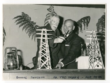
black and white photograph, second half 20th century
This was the switch on ceremony for the power going to Bonang. The ribbon was cut by Mr Ted Ingram at the age of 100. Ted Ingram, was one of 22 children. The Ingram family originated from the Bombala, Bonang and Delegate area, migrating throughout out the rich farming country of East Gippsland in the early 1900s.This is a pictorial record of a significant event in the history of East Gippsland.A black / white photograph of two men cutting the ribbon at an official occasion. The ribbno is strung between to models of electricity pylons. On the table to the left is a kerosene lantern.on front - "Bonang Switch on, Mr Ted Ingram, age 100 years"bonang-electricity-supply ingram-ted -
 Orbost & District Historical Society
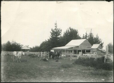
black and white photograph, first half 20th century
Mr John Watt set up farming in 1879. He was a native of Port Fairy. He was educated in Scotland and came back to Victoria and selected 320 acres on the Snowy River.The property extended from Majors Creek Road to around about Gilbert's Gulch.This is associated with John Watt, a prominent early settler in Orbost.A black / white photograph of a dilapidated farm shed with three horses in the foreground. A house can be seen in the background (left) behind a fence. on back - "Watts Farm"watt-john-orbost farming-buildings -
 Orbost & District Historical Society
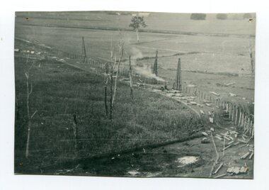
black and white photograph, 1916
This photograph shows the pile drivers at work in the construction of the viaduct across the Snowy River flats. The Snowy River Floodplain Railway Bridges, two sequential and exceptionally long and low timber railway bridges on the Snowy River floodplain just west of Orbost, were built in 1916, and provided the original terminus point for the Bairnsdale-Orbost railway. The bridges are 770 metres and 183 metres long respectively. The shorter bridge is of uniformly 4.57 metre timber-beam construction, and has a sweeping curve in its deck. The longer bridge has a combination of 4.57 metre and 6.1 metrespans, and two 3.66 metre spans. The bridges are constructed from 'Southern Mahogany', Eucalyptus Botryoides, which grew along the coast east of Bairnsdale. The Snowy floodplain bridges were initially built in the context of an early twentieth-century interest in American-style 'Developmental Railways', designed to open remote areas to closer settlement, even if that meant running at a loss. The line was closed in August 1987. (information from Victorian Heritage Database)This item is associated with the history of the Orbost-Bairnsdale railway line and therefore reflects the role that the rail line played in the social and economic history of Orbost.A black / white photograph of the farming flats at Orbost during the construction of the East Gippsland railway.orbost-railway east-gippsland-railway viaduct-orbost transport railway -
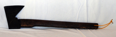 Orbost & District Historical Society
trade axe, Early 20th -mid 20th century
This axe is fitted with a smaller head and handle than a felling axe and is probably for one-handed use. It would be used for trimming limbs and for small chopping jobs.This is an example of a tool commonly used by early generations of Orbost settlers.A wooden handled axe. The top edge of the iron blade is straight and the shape is a right-angled triangle. A yellow cord is threaded through the handleaxe trade-axe timber farming tool -
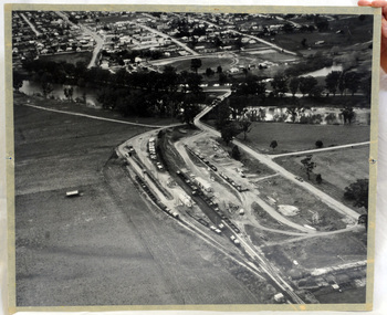 Orbost & District Historical Society
aerial photograph, 1970's
... and operated until 1987, principally carrying timber and farming ...This photograph was taken prior to the closure of the Orbost -Bairnsdale freight line in 1987.The Orbost-Bairnsdale railway initially played a crucial role in developing agricultural industries in Gippsland as well as tourism. It opened in 1916 and operated until 1987, principally carrying timber and farming produce. In the early days of the railway's operation dedicated passenger trains ran but these ceased by the 1930s. The line was completely closed to freightage in 1987.The track infrastructure was dismantled in 1994 and has been redeveloped as the East Gippsland Rail Trail.A large black and white aerial photograph of Orbost Railway Station in the foreground and the Orbost township in the background. It has been pasted onto a piece of Masonite. railway photography orbost, railway photography orbost -
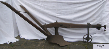 Flagstaff Hill Maritime Museum and Village
Tool - Plough, Syracuse Chilled Plow Co, 1876-1900
The Syracuse Chilled Plough Company was created in 1876 and specialised in the manufacture of agricultural ploughs. Harry Wiard invented the chilling process in plough manufacture. The company was originally founded as the Robinson Chilled Plough Company in 1876 and changed its name 3 years later. At its peak, in the early 20th century. The company made more than 100,000 horse-drawn ploughs and road scrapers of various designs that were sold from the Syracuse plant each year and exported around the world. The company slogan of the day was, “The sun never sets on a Syracuse plough." Eventually, other farming implements were added to the line. The company employed more than 300 people in its local plant, which covered a square block on the cities Near West Side. In 1910-11, Deere and Company began expanding its holdings, and with the success of the Syracuse Chilled Plough Company, Deere sought to acquire the company. The management of the Syracuse operation after John Deere took over remained in the hands of Wiard and Chase, and the manufacturing operations were left in Syracuse. The only change from previous Syracuse operations was the selling of the companies products through Deere retail outlets instead of directly to the trade. The factory in Syracuse continued to produce ploughs until 1955. The subject item in the Flagstaff collection is an early model Syracuse Chilled plough with a wooden beam frame it is very much lighter in weight and was adapted to work sandy or light loamy soil. This plough has a sloping landside, which tends to keep the clods and dirt from falling into the furrow, making the ploughman's work much more comfortable and easy. This design was made in eight sizes for both right and left-handed ploughing and became very popular in the far West and South of the USA. Note: The definition of a chill plough means : a plough having the share and mould-board of chilled semi steel or cast iron.The subject item is believed to be a very early plough given its wooden beam frame and was made before 1900 probably around 1880. This makes it a significant example of the types of plough that early settlers were using in Victoria. There would not be very many of this type of vintage plough left with a wooden beam and frame, making it today a desirable collector's item. Syracuse Wood Beam Chilled single furrow plough metal wheel in front. Syracuse Chiller Co Syracuse & 50 L stamped on ploughshare.flagstaff hill, warrnambool, shipwrecked-coast, flagstaff-hill, flagstaff-hill-maritime-museum, maritime-museum, shipwreck-coast, flagstaff-hill-maritime-village, plough, syracuse chiller co, chiller plourh, farm equipment, furrow -
 Phillip Island and District Historical Society Inc.
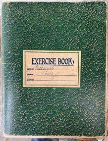
Book, Articles on severance poll concerning split from Shire of Phillip Island and Woolamai 1925-1929, 1925-1929
Issue of severance of Phillip Island from the Shire of Phillip Island and Woolamai to become Shire of Phillip Island 1925-1929. This issue had strong opinions on both sides amongst Island residents and shows the political landscape of the times. This is a snapshot of life on Phillip Island in the 1920s. Book also contains notes, poem by D.H. Robb in his handwriting.HistoricalGreen exercise book with handwritten notes, articles from newspapers, pamphlets.Cover states D.H.Robb, Cowes. Lists of absentee ratepayers and householders, objectors,d.h.robb, severance of phillip island, local government, w.d.davie, akt sambell, women's progress association, phillip island early roads, phillip island valuations, local identities, reverend rath, tourism, phillip island 1920s, farming -
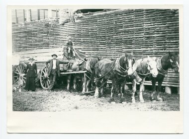 Orbost & District Historical Society
black and white photograph, first half 20th century
Mr John Watt set up farming in 1879. He was a native of Port Fairy. He was educated in Scotland and came back to Victoria and selected 320 acres on the Snowy.The property extended from Majors Creek Road to around about Gilbert's Gulch.This is associated with John Watt, a prominent early settler in Orbost.A black / white photograph of a horse-drawn wagon with a man, lady and a dog standing beside it. There is a young boy holding a whip sitting on top of the wagon. Behind the wagon is a large wooden slatted barn.on back - " a farm down Marlo Rd - Watts)farmhouse transport-horse-drawn watt-john -
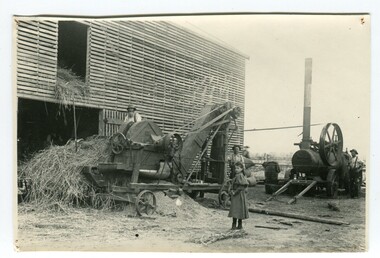 Orbost & District Historical Society
black and white photograph, 1892
The photograph shows a chaff cutter on John Watt's farm about 1892. Mr John Watt set up farming in 1879. He was a native of Port Fairy. He was educated in Scotland and came back to Victoria and selected 320 acres on the Snowy River.The property extended from Majors Creek Road to around about Gilbert's Gulch.this item is associated with John Watt an early Orbost settler.A black / white photograph of a large wooden slatted barn with motorised farm machinery outside . There are three men with the machines and a young girl watching.agriculture-machinery farming-orbost watt-john -
 Orbost & District Historical Society
black and white photograph, Warren. Mrs H, first half 20th century
Many farmers on the flats at Orbost used to grow a lot of maize and harvest the maize by putting the pigs in to eat the maize.. Maize and pumpkins fed in conjunction were largely used for fattening pigs. The photographer was Warren, Helena (1871-1962) who was a self-taught photographer who became both the local press correspondent and a producer of humorous trompe l'oeil postcard images. Helena Warren was a thirty-two year old settler living on a small mixed farm with her husband, William, at Newmerella, near Orbost in Gippsland, Victoria, when she bought her first camera, an Austral Box quarter-plate. Her family says she was entirely self-taught, like many women photographers who started out with nothing but the instructions on the packets of film and chemicals. In over fifty years practice she graduated from the total novice, who opened all her first mail order plates in bright sunlight and ruined them, to a competent photographer who became both the local press correspondent and an inveterate producer of humorous trompe l’oeil postcard images.This item is a pictorial record of farming in Orbost in the early 20th century. It is also associated with Helena Warren. a well-known photographer born in Orbost.a black / white photographagriculture farming-orbost pumpkins maize pigs warren-helena -
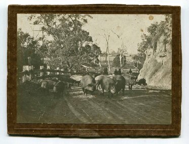
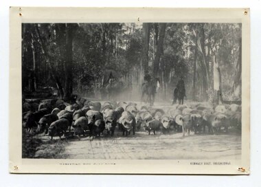 Orbost & District Historical Society
black and white photograph, C1890's
... ferried across the rivers. This is a pictorial record of early ...Farmers on the Orbost flats and nearby districts used to grow a lot of maize and harvest the maize by putting the pigs in to eat the maize. They had to get the pigs to Bairnsdale with other chaps, droving about 600 pigs. It would take them 12 days. A wagonette would go in front and dribble out the maize. When they reached Swan Reach, the drovers would often go over to the old grog shanty and got drunk while one man would stay to keep the 600 pigs together. It was a difficult job. The pigs were ferried across the rivers. This is a pictorial record of early farming in East Gippsland.A black / white photograph of men on horseback droving pigs from the Cann River district to market along a dirt road.pigs agriculture farming-orbost-cann river -
 Orbost & District Historical Society
black and white photograph, C1900
... practices in the early 20th century. agriculture farming-Orbost pigs ...Pigs were taken to Bairnsdale by coaxing them with maize thrown from a wagonette . From Bairnsdale they were freighted to market by train. The journey to Bairnsdale took about five days . This method of transport continued until the rail line to Orbost was opened in 1916.This photograph is a pictorial record of farming practices in the early 20th century.A black / white photograph on a brown buff card showing pigs being taken to market. The photograph shows the pigs close up with men on horseback behind them. The pigs are on a gravel road with a fence on one side and and the Orbost flats can be seen in the background.on back - "Pigs being driven from Orbost to Bairnsdale. M.Gilbert, Orbost"agriculture farming-orbost pigs -
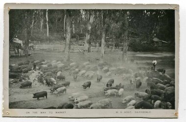 Orbost & District Historical Society
black and white photograph, late 19th century - early 20th century
... farming practices in the early 20th century. agriculture farming ...Pigs were taken to Bairnsdale by coaxing them with maize thrown from a wagonette . From Bairnsdale they were freighted to market by train. The journey to Bairnsdale took about five days . This method of transport continued until the rail line to Orbost was opened in 1916. This photograph is a pictorial record of Orbost farming practices in the early 20th century.A black / white photograph of pigs being taken to market. There are men on horseback with them.on front - On the Way to Market W.S. Vogt Bairnsdaleagriculture farming-orbost pigs -
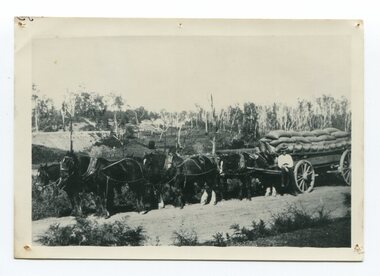 Orbost & District Historical Society
black and white photograph, late 19th century - early 20th century
... ) This is a pictorial record of farming practices in Orbost in the early 20th ...Maize, or corn as it is called in America and New South Wales, has been grown on the Orbost flats for at least 70 years. When early settlers began to arrive on the Snowy River somewhere in the 1880s, the land was mostly swamps and heavily timbered jungle on the river frontages. The swamps were drained, bit by bit, by stout hearted men with short handled shovels and working in mud and water. The frontages were cleared by axe and shovel and fire. Several kinds of crops were experimented with such as hops, hemp and maize, the latter grew particularly well and became the main crop of district. The problem then was to thresh and deliver the product to the market. A small single cob machine was brought here and one man turned the handle, while the boy or Mum fed the cobs singly into the machine. A good day’s work would thresh about 50 bushels or about 12 bags (4 bushels). The task then was to cart the maize to market. For a few years this was done by horses and dray carrying about 60 bushels to Mossiface, where it was loaded onto river boats to Lakes Entrance, and then by ocean boats to Melbourne. ( from NEWSLETTER OCTOBER, 2006) This is a pictorial record of farming practices in Orbost in the early 20th century.A black / white photograph of a horse team hauling a wagon loaded with bags of maize.A man is sitting on the edge of the wagon.farming-orbost agriculture maize corn transport -
 Warrnambool and District Historical Society Inc.
Certificate - Federation Celebration Rolfe invitation, 1901
This invitation to a ‘Conversazione’ to celebrate the Federation of the six colonies in Australia into the six States of Australia in 1901 was sent to the invitees after the event to keep as a souvenir of the occasion. The event was hosted by the Government of Victoria. The certificate was designed by George Brougham Austin, a Melbourne architect and artist employed by the Victorian Department of Public Works. He also designed many of the public decorations displayed in Melbourne during the Federation celebrations. Austin’s original work was lithographed by an artist at Sands and McDougall, Melbourne. This particular invitation was sent to George Rolfe and his wife, Annie. George Rolfe (1836-1919), a tea merchant from Melbourne, began buying blocks of land near the mouth of the Hopkins River in Warrnambool in the 1870s. By the early 1880s he owned 50 acres of land in the town and some nearby farming properties. He used the building on the ]and near the mouth of the Hopkins River as holiday accommodation and called the property, Lyndoch. He improved the property with the additions of stables, jetty, boathouse, bone and chaff sheds, reservoir and windmill and extensive gardens. Rolfe spent most of his later life at Lyndoch. Today the property is the site of an Aged Care facility. This certificate is of considerable importance for two reasons: 1. It is an important and attractive memento of a signal event in the history of Australia – the Federation of the States in 1901. 2. The certificate was an invitation to Mr and Mrs George Rolfe. George Rolfe was a prominent Warrnambool person in the late 19th and early 20th centuries. This is a multi-coloured certificate printed on a cream-coloured card. The certificate has an image of the Exhibition Building surrounded by an ornate border of heraldic shields, portraits of the Duke and Duchess of Cornwall and York, views of the six capital cities of Australia, native flora and fauna, the Royal Crest and the Crest of Australia. The names of the invitees are handwritten in black ink. ‘United Australia 1901 One Flag One Hope One Destiny Australian Commonwealth Celebrations’ ‘The Government of Victoria requests the honor of the presence of Mr & Mrs G. Rolfe at a Conversazione in the Exhibition Building on the Evening of Tuesday 7th May 1901 at 8 p.m.’ george rolfe of lyndoch, warrnambool, federation of australia, history of warrnambool, george rolfe -
 Warrnambool and District Historical Society Inc.
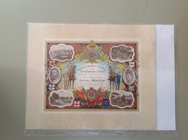
Certificate - Royal Review 1901 G Rolfe, 1901
This certificate was sent to those who had been present at one of the celebrations in connection with the Federation of the six States of Australia in 1901 – The Royal Review at Flemington Racecourse on 10th May 1901. The invitation to attend the event was issued by the Government of Victoria. The certificate was intended to be kept as a souvenir of the event and framed. This particular certificate was issued to George Rolfe and his wife of Warrnambool. George Rolfe (1836-1919), a tea merchant from Melbourne, began buying blocks of land near the mouth of the Hopkins River in Warrnambool in the 1870s. By the early 1880s he had acquired 50 acres of land in the town and several farming properties. He used the buildings on the land near the mouth of the Hopkins River as holiday accommodation and called the property, Lyndoch. He improved the property by adding stables, chaff and bone sheds, jetty, boathouse, reservoir, water well and windmill and extensive gardens and he spent most of his later life in the Warrnambool area. Lyndoch today is the site of an aged care facility. This certificate is of considerable importance for two reasons: 1. It is an important memento of a signal event on Australia’s history – the Federation of the six States in 1901 and the subsequent celebrations. 2. The certificate was issued to a prominent Warrnambool person, George Rolfe and his wife.This is multi-coloured sheet of paper mounted on card. There are four black and white photographs of the Royal Review at Flemington and photographs of the Duke and Duchess of Cornwall and York. The images include the Royal Crest, the shields of the six Australian States, a shield of Victoria with a background of flags, cannon and ammunition, two mounted soldiers with a soldier and sailor standing nearby and swords and bayonets. There is also much colour decoration around the edges of the certificate. The names of Mr and Mrs Rolfe are handwritten in black ink. ‘Australian Commonwealth Celebrations’ ‘The Government of Victoria requests the honour of the presence of Mr & Mrs G. Rolfe at the Royal Review at Flemington on Friday the 10th of May 1901’ federation of australian states, george rolfe of lyndoch, history of warrnambool, george rolfe -
 Warrnambool and District Historical Society Inc.
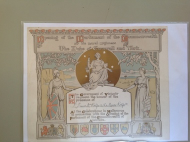
Certificate - Invitation to the opening of the Parliament of the Commonwealth of Australia, 1900
This certificate is an invitation to the opening of the first Parliament of Australia on January 1st 1901 in Melbourne. On this date the six Australian self-governing colonies were federated to become the six states of Australia. The designers of the certificate were Norman Lindsay and John Longstaff. This particular invitation was sent to George Rolfe and his wife and two of his stepdaughters, Annie and Florence. George Rolfe (1836-1919), a tea merchant from Melbourne, began buying blocks of land near the mouth of the Hopkins River in Warrnambool in the 1870s. By the early 1880s Rolfe owned 50 acres in the town, including farming properties and used the buildings near the mouth of the Hopkins as holiday accommodation. He called his property Lyndoch which he improved with the addition of stables, chaff and bone sheds, jetty, boathouse, reservoir, water well and windmill and extensive gardens and he spent most of his later life in this Warrnambool area. Lyndoch today is the site of an aged care facility. This certificate is of considerable importance for two reasons: 1. It is an important memento of a signal event in Australia’s history - the Federation of the States in 1901. 2. The certificate was an invitation to the family of a prominent Warrnambool person – George Rolfe of Lyndoch.This is a piece of thick paper with illustrations and decorations in brown, red, blue, yellow and green tonings. The lettering is in white with coloured capital letters. The images include the shields of the six Australian States, the Coat of Arms of Britain and Australia, outlines of two trees (gum tree and oak tree) and three symbolic female figures representing Justice, Britannia and Australia. The top border decoration represents the waratah flower. The names of the invitees on this certificate have been handwritten in black ink. ‘Opening of the Parliament of the Commonwealth by His Royal Highness The Duke of Cornwall and York’ ‘Mr G and Mrs Rolfe and the Misses Rolfe (2)’ george rolfe of lyndoch, federation of australia, history of warrnambool, george rolfe, opening of first parliament of australia -
 Warrnambool and District Historical Society Inc.
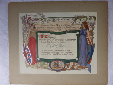
Certificate, Duke of Cornwall
This certificate is an invitation to the Evening Reception in Melbourne in 1901, an event which was part of the celebrations in Melbourne to commemorate the Federation of the six colonies into the six States of Australia in January 1901. The certificate was sent to the invitees after the event as a souvenir of the occasion. The certificate was designed by the artists Julian and Howard Ashton and lithographed and issued by Sands and McDougall Limited of Melbourne. This particular certificate was sent to George Rolfe and his wife Annie. George Rolfe (1836-1919), a tea merchant from Melbourne, began buying blocks of land near the mouth of the Hopkins River in the 1870s. By the early 1880s he had acquired 50 acres of land in the town and several nearby farming properties. He used the buildings on the land at the mouth of the River Hopkins as holiday accommodation and called this property Lyndoch. Rolfe improved this property adding stables, jetty, boathouse, bone and chaff sheds, reservoir and windmill and extensive gardens. Rolfe spent most of his later life at Lyndoch. Today the property is the site of an Aged Care Facility. This certificate is of considerable importance for two reasons: 1. It is an attractive and valuable memento of a signal event in Australia’s history – the Federation of the States in 1901. 2. The certificate was an invitation to Mr and Mrs George Rolfe. Rolfe was a prominent person in Warrnambool in the late 19th and early 20th centuries. This is a multi-coloured certificate mounted on a piece of grey cardboard. The certificate is highly embossed and has a figure of Britannia in a red dress and a mailed vest holding a shield with the Union Jack emblem. Britannia is extending her hand to a figure of a younger woman representing Australia. This figure is dressed in blue and holds a shield which has a blue cross with white stars. The borders have vines and vine leaves and the Royal Crest is at the base of the certificate. The names of the invitees are handwritten in black ink. ‘In Celebration of the Opening of the Parliament of the Commonwealth of Australia, To Meet Their Royal Highnesses, the Duke and Duchess of Cornwall and York, His Majesty’s Ministers of State for Australia have the honor to invite Mr & Mrs G. Rolfe to an Evening Reception at the Exhibition Building, Melbourne on the 9th of May 1901, at 8 0’clock’. george rolfe of lyndoch, warrnambool, federation of australia, history of warrnambool, george rolfe -
 Warrnambool and District Historical Society Inc.
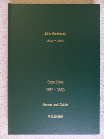
Book - Facsimile: John Mackersey 1826-1892, Stock Book 1857-1870, 2014
This ledger relates to the property Kenilworth which is situated near Cavendish, 16 miles from Hamilton on the Wannon River. It was taken up by Thomas Norris in 1839 and originally carried 800 cattle and 20000 sheep on 63000 acres. By 1858 it was in the hands of John Mackersey and Thomas Bostock. In 1859 it belonged outright to John Mackersey who was there until 1870. He was considered a worthy son of a Presbyterian minister and was well regarded in the district for his contributions in church, sport and sheep breeding... However he did not do well and lost the property before going to New Zealand in 1870. These journals provide a yearly record of flock, harvest and yields along with income details. It also provides details relating to rentals, selections and purchases during the era from squatting to freehold land. This journal provides a detailed view of matters relating to the business of sheep farming. It records purchases and stock sold, wool clips, lambs, sheep losses and different breeds. Kenilworth was a significant property in the Western District of Victoria and it dates from a period of early settlement in Victoria.Dark green hard cover with gold lettering. Both covers have in gold lettering: John Mackersey1826-1892 Stock Book 1857-1870. One cover has Horses and cattle and the other, sheep. It is a facsimile copy. The two sections are divided by a green sheet of paper. Acknowledgements to The State Government of Victoria, State Library of Victoria, Hamilton History Centre, Dr G Handbury AO, Margaret Gardiner, Godfrey and Margaret Mackersey, L Alan Brumley, M P Heuval. john mackersey, thomas bostock, thomas norris, kenilworth, history of warrnambool -
 Warrnambool and District Historical Society Inc.
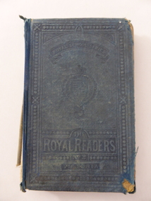
Book, The Royal Readers, Late 19th century
This book is one of the series of Royal Readers (Scotland) introduced into schools in Victoria in 1877 to replace the Irish Readers. They were in use until the 1920s and at first contained mostly British material (as does this copy which has no Australian content and features many articles on animals). By the late 19th century the Royal Readers used in Victoria contained some Australian material and it is presumed that this copy is an early edition. The Bonnett families were associated with farming in the Mepunga area and Jessie Edith Bonnett, the daughter of Frederick Bonnett and Charity Bonnett (nee Phillips) was born in Allansford in 1897. Jessie Bonnett spent her life on the family farm at Mepunga and was the last of the Bonnett families in that area. Mepunga East State School was established in 1886 with Ruth Broadway as the first Head Teacher. It has now closed. This book, though tattered, is of interest as an example of the Royal Readers used by pupils in Victorian schools in the late 19th and early 20th centuries. It is also important as a book belonging to Jessie Bonnett, a member of the Bonnett family of farmers in the Mepunga area. The Warrnambool and District Historical Society holds in its collection some other items that belonged to Jessie Bonnett, including an important World War One scrapbookThis is a hard cover book of 186 pages. The cover was originally a dark blue-green colour but it is much faded and is now almost detached from the binding. The spine and several pages at the beginning and the end are missing. The text contains many black and white illustrations and some have been coloured in. Some of the pages are torn and stained. There is much scribble on the front and back covers. The inscriptions are handwritten in black ink.‘Jessie Edith Bonnett, Mepunga East State School No. 2762’ jessie bonnett, mepunga east state school -
 Kiewa Valley Historical Society
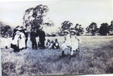
Photograph - Tawonga Sports Day
Tawonga is in the Kiewa Valley, where local farmers lived with their families. The Ryder and Briggs families have been prominent farming families in the local area since early settlement. Vera Ryder and Alli Briggs were pupils at Tawonga Primary School in the early 1920's. Their families were prominent in the settlement of the Kiewa ValleyCopy of black and white photograph of 3 legged race at Tawonga Sports Day circa 1920's (estimate only) Vera Ryder & Allie Briggs racing in the foreground. Various adults and children standing in the background.Printed label attached to rear. Tawonga Sports Day. Vera Ryder and Allie Briggs - 3 legged race. Girls have white aprons over their dresses.tawonga, sports day, kiewa valley farmers -
 Kiewa Valley Historical Society
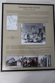
Posters - "Tawonga Remembers" x 5, 2016
The town of Tawonga is in the Kiewa Valley surrounded by farmland. It is adjacent to Mt Beauty (built from 1946), an SECV town built for workers on the SECV's Kiewa Hydro Electric Scheme, which was being constructed from 1911-1961. Tawonga consists of essential amenities including a store, school, post office, butter factory, sporting facilities, hall and hotel. Activities involved sport, social get togethers eg. dances, fund raising, CWA etc.The posters are a collection of historical photos, documentation and information re the history of the town of Tawonga, which is the centre of a farming community in the Kiewa Valley.Posters framed with thin black plastic strip, covered by glass. Each one has a title re "Tawonga Remembers" and includes print and photos in black and white. These have a beige background. 1. Tawonga 1907; 2. Tawonga 1962; 3. Tawonga State School- 1880-1929; 4. Tawonga Primary School -1960; 5. The Beginning of Change: 1930-1970tawonga, photos of early tawonga, kiewa valley, tawonga remembers, tawonga school -
 Kiewa Valley Historical Society
Photographs – Set of 4 black and white photographs. One of a wooden church and three of rural homes and farmland. Area not identified
Europeans arrived in the Kiewa and Ovens Valleys in the 1830's and 40's. Following the drought of 1838-44, seeking out the rich pastures in the fertile Valleys. It proved to be perfect conditions for dairy farming and the raising of cattle. Miners Cottages and other similar wooden structures were a common sight in the area as they were a modest form of accommodation for their period, were quick to erect and economical as they made use of locally available building materials such as local timbers.These photographs provide a snapshot into the early dwellings and architecture of the Kiewa and Ovens Valley regions, including buildings such as the church, which provided an important gathering place for social interaction, especially in these isolated areas.1-Wooden church building with no identification. Large tree in the foreground in front of church 2&3- Black and white photographs of farmland and assorted dwellings, mostly miners style cottages in a valley with mountains in the background. A bridge with wooden railings is visible over the river in the middle of the photograph, also a more modern dwelling is visible in the north east of the photograph close to the river. 4-Black and white photograph of residential homes and farmland with an unsealed road running through the middle. Foreground shows a field which has been semi cleared of trees (stumps remaining). In the background are larger farming properties with the road disappearing into the distant hills. This might be Old Tallangatta before the town was moved in 1956. 1-3 - No inscriptions 4- Signature written on back in lead pencil - Sandra Templebuildings; church; farmland -
 Kiewa Valley Historical Society
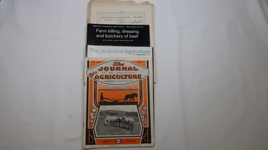
Journals - Department of Agriculture, 1. 1950s and 2. one 1932 & others 1970s
... The Kiewa Valley has been a farming district from early... Valley has been a farming district from early settlement of white ...The Kiewa Valley has been a farming district from early settlement of white people. This has continued until the present although the nature of farming has varied over the years. Access to information has improved with transport and technology. The journals kept the farmers informed and up to date.These booklets and journals were one of the few sources of information during the 1950s for the isolated farmers of the Kiewa Valley. The Kiewa Hydro Electric Scheme improved both transport and technology during the scheme's construction from the 1940s. It provided the township of Mt Beauty at the upper end of the valley where shops and schools were constructed, roads were improved out of the valley and the supply of electricity for milking etc. became available. 1. 14 articles each bounded by 2 staples, and each reprinted from Dept. of Agriculture Journal on a particular topic relating to Agriculture. All black & white and c1950s. 2. 4 Journals with colored covers 3 from Victoria Dept. of Agriculture (1932, 1974 & 1975) and 1 from Sth. Australia.1. "J.H.Wallace" hand written top right corner of covers of pamphlets titled 'Diseases Affecting /Young Cattle' and 'Mastitis'. "AHW" hand written top right corner of cover of pamphlet titled ' Grading Land for Irrigation' 2. Nonefarming, agriculture, cattle, pasture, kiewa valley, department of agriculture in victoria, kiewa hydro electric scheme, -
 Kiewa Valley Historical Society
Photograph - 30 black and white photographs (assorted sizes) plus page from a newspaper and copied article on A4 paper, c1880's c1910 - 1920 (photographs) Newspaper 1961
... and historical significance as they are of early farming families ...K2,3 and4 are of the Kiewa River and two of the bridges spanning the river along the valley. K3 and K4 would have been taken in the 1880's and show the type of trees and plant growth along the river prior to land clearing for farming. K5 is of the Running Creek Cricket Team and therefore there was sufficient population in the area to form and maintain a team as well as have other teams in the relatively near vicinity to provide competition. Note the horse drawn cart which provided transport. Date taken is unknown but possibly c 1910. The Mt. Buffalo Chalet was built in 1910 by the Victorian Government. It was Australia's first ski resort and has served generations of skiiers, hikers and families over the years. It was built for 3195 pounds and has had stories and wings added since and is the largest timber building in Australia. B4 is the earliest photo in this group as the garden is in early stages of development - the other photos show the growth of the shrubs and would be taken about c 1920. Note the cars and motor bikes. It closed in 2006. The other photos are of general interest only but interesting to see that there were donkey's grazing. There is no information as to their purpose on Mt. Buffalo. Four different Kiewa Valley families are represented in the photographs. Their descendants still live in the Valley and carry on the traditions of beef and dairy farming. Of particular interest is the photo of Miss Marjorie Clemence, the first School Teacher of Upper Gundowring School. Gundowring pastoral run was taken up in 1838 and occupied by framers in the 1860's. The area was known as Gundowring and Upper Gundowring. The Gundowring School was opened in 1871 and most likely the Upper Gundowring school would be built at the same time. It was School No. 2733 and situated in Boyd Road. It closed in 1953 when the Kiewa Consolidated School opened. The newspaper page describes the activities in which the local community of Kergunyah were in engaged in that period - Red Cross, Fire Brigade, cattle round up and some of the identities involved. The article photocopied from the Yackandandah times states that he (Norman Coad) "was sent to the Ovens District Hospital, Beechworth for treatment" which would mean that this was the closest hospital to the Kiewa Valley for emergencies in 1912.The Kiewa Valley photographs are of social significance showing two of the early bridges allowing the community easy access to both sides of the river and also the tree and plant growth before land clearing for farming. The photos of Mt. Buffalo Chalet have social, architectural and historical significance. the Chalet has been used by skiers, bush walkers and day trippers since its completion in 1910 and its closure in 2006. It is listed in the Victorian Heritage Register. The family photographs are of social and historical significance as they are of early farming families in the Kiewa Valley and also depict the dress, of both men and women) in the late 1880's. The write up in the Weekly Times has social significance as it depicts the social and farming activities and photos of the local residents from around that area. The article from the Yackandandah Times is of a personal nature with concern for the individual involved. Note: There is a photo of the gentleman mentioned in the article (Mr. Norman Coad) in the Families of the Kiewa Valley (F4) as above.30 black and white photographs - 5 of the Kiewa Valley, 8 of families of the Kiewa Vallley and 17 of Mt. Buffalo. Various sized photos. Page from the Weekly times and copied article from the Yackandandah Times on A4 sheet.(Note for easier identification they have been numbered and grouped - K1-5 (Kiewa Valley), F1-8 (Families) and B1-17 (Mt. Buffalo). K1: handwritten in ink, lower L hand corner "Bogong in the distance". K2: handwritten in ink lower L hand corner "Mongan's Bridge or Towonga". K3 handwritten in ink "Taken from Mongan Bridge looking up stream". K4 - no inscription. K5: handwritten in ink, back of photo "Running Creek Cricket Team". F1: handwritten in ink on back "Mrs. Heap" and lower down in pencil "1880's". F2 handwritten in pencil at top of back phot "Land at Tawonga TROVE The Y'dah Times 20/2/1913" and lower down in ink "Henry Ellis Larkin". F3: handwritten in ink bottom edge "Mrs Coad". Note that this photo is a postcard. F4: Written in ink lower edge "Norman Coad". Note this photo is also a postcard. F5: Lower left corner in Ink "Harry Larkin". F6: lower half back of photo, in ink "Bernie Maddison". F7: on back of photograph in ink "Miss Marjorie Clemence first School Teacher Upper Gundowring: and underneath, in pencil "C1880's". F8: Handwritten in ink on back of photo "Frank & Mrs. Keat & Lesley of Tawonga". Lower down in pencil "c1912-1914". B1: Back of photo in ink "The Chalet Mt. Buffalo". B2: no inscription. B3: "chalet at Bufflo" in ink lower left corner. B4: This is a post card. Written in ink is "Mt. Buffalo Chalet". B5 - B10 printed in ink, lower left corner "Buffalo". B11: no inscription. B12: "Mt. Buffalo" lower R corner. B13: "Buffalo?". B15: Printed in ink lower edge "Picnic at Buffalo". B16: "Donkeys on Mt. Buffalo" printed in ink lower edge. B17: handwritten in ink across back of photo "Donkeys & top of Mt. Buffalo with the Monileith in the distance". A4 sheet of paper describing an accident to Mr. Norman Coad. Under article is : Yackandandah Times (Vic: 1890 - 1931), Thursday 18 July 1912, page 3. A page torn from the Weekly Times, June 14, 1961 and entitled "Kergunyah has picturesque setting". kiewa valley, farming, families, kergunyah, gundowring upper, mt. buffalo chalet, briggs family, larki family, coad family, clemence family, laskowski collection