Showing 95 items matching "farming settlements"
-
 Phillip Island and District Historical Society Inc.
Photograph, Bryant West
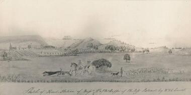
... settlement black & white photograph farming settlement mchaffie john ...One of a collection of over 400 photographs in an album commenced in 1960 and presented to the Phillip Island & Westernport Historical Society by the Shire of Phillip IslandPhotograph of a Sketch of Head Station of Messrs. W & W J McHaffie by W. & E. Liardet. Copy of water colour by Victoria's earliest artist late 1840's.Hand written inscription by W. J. McHaffie - "Sketch of Head Station of Mssrs. W & J.M. McHaffie of Phillip Island by W.F.E. Liardet."local history, photography, photographs, painting, early settlement, black & white photograph, farming, settlement, mchaffie, john jenner, bryant west -
 Greensborough Historical Society
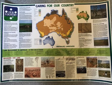
Poster, National Farmer's Federation et al, Caring for our Country, 1988c
A timeline of land management including indigenous care and the impact of European settlement from 1988 to 1987. Includes maps showing present land use and vegetation coverage in 1788. Prepared by Tim Gurry for the National Farmer’s FederationLaminated poster, printed in colour on one side.land management, farming, salinity -
 City of Moorabbin Historical Society (Operating the Box Cottage Museum)
Manufactured Glass, milk bottle 'Black Rock Dairy', 20thC
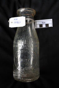
Alfred R Varcoe was a dairyman with stables, cart shed and his house in Eliza Street, Black Rock, Victoria. Dairy farming was established early in the settlement of the Brighton / Moorabbin area following the Dendy's Special Survey 1841 and subsequent land sales c1850. The produce was taken to feed the population of Melbourne and local residents.A clear glass ,1 pint , milk bottle used by Black Rock Dairy, MelbourneTHIS BOTTLE CONTAINS/ MILK / BOTTLED FOR SALE BY / BLACK ROCK MODEL / DAIRY / BLACK ROCK / BOTTLE IS THE PROPERTY OF THE ABOVE / IT IS OWNED AND CANNOT BE LEGALLY USED BY OTHERS/ ONE IMPERIAL PINT on base 440market gardeners, early settlers, farmers, dairies, milk production, moorabbin shire, moorabbin, cheltenham, black rock, brighton, dairy farmers, bottles, glass manufacture, varcoe alfred r; black rock dairy, dairy farmer, dairy products sales and deliveries, -
 Kiewa Valley Historical Society
Photograph Shovel Truck, Shovel Loading Rail Truck, circa 1950s
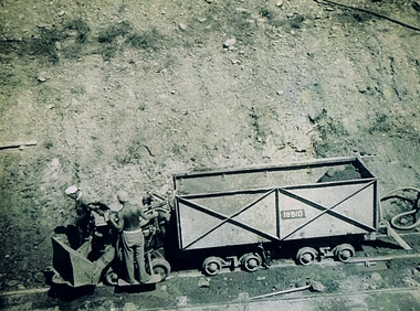
This item shows the excavation of the side of a railway track using a pneumatic shovel and a rail mounted truck by two workmen. The period covered was well before State Health and Safety requirements, such as helmets, became law. It also details that the workmen were from European heritage as their head coverings were a handkerchief knotted at each corner. This was typical for workmen of this heritage, others used caps or hats or no head covering at all (the macho male look)The photograph of this item was one of many depicting great achievements and opening up the region. A visual link or time capsule of the 1950s rural/mining sectors clashing with the established rural industriesThis photo depicts the time (1950's) and place (Bogong and Mount Beauty) where construction workers had an immense impact, not only on the physical environment but also on the social and economic development of the Victorian Alps region. The fast expansion of smaller settlements brought about increased pressures on the welfare viability of certain subgroups within the region e.g. farming, droving and commerce (caravan hawkers versus static shops). These changes brought about a heightened awareness by both local and State Governments to upgrade not only facilities within the region but also access to the region. Black and white photo of two workmen on a rail mounted shovel truck. The photo is of good definition allowing a clear view of the subject matter. The paper is semi gloss.On the back of the photo, paper suppliers etchings are "Kodak XtraLife II paper"mining, hydro electricity, victorian alps, construction camps, earth moving machines -
 Warrnambool and District Historical Society Inc.
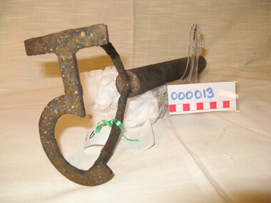
Functional object - Farming Equipment Branding Iron, Circa 1840
Armyne, George and Lemuel Bolden were original landholders of large parts of land in the Western district. Portions of it extended from Pirron Yallock in the East to almost as far as Portland. The head station was at Grasmere. They were noted breeders of shorthorn cattle in fact they were some of the first men to bring the breed to Victoria and thus helped to pioneer the Australian Shorthorn breeding Industry. This branding iron was found at Lyall Park, originally 640 acres selected by William Lyall at Cooramook. It is believed to be a branding iron dating from when the land was occupied by the Bolden Brothers. The Bolden Brothers were the first to erect considerable lengths of fencing in the Warrnambool area. If this item is an authentic Bolden piece of property then it is the oldest artefact from the time of white settlement that is held by the Warrnambool and district Historical society. The item itself while a common farming implement and which was found on a farm originally owned by the Bolden Brothers is a link with the earliest part of Warrnambool’s history.Short, round wooden handle with metal brand in the shape of the letter T with two thirds circle attached to vertical part of T. Daub of paint at end of handle . T 5Paper label attached with green tape with 931 in texta and hand written on back,” branding iron reputed to have been used by Bolden Bros Grasmere c 1840. warrnambool, bolden brothers, armyne bolden, george bolden, lemuel bolden, branding iron, shorthorn cattle -
 Warrnambool and District Historical Society Inc.
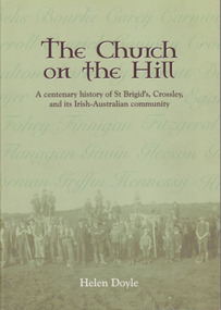
Book, Helen Doyle, The Church on the Hill :A centenary history of St. Brigid’s Crossley and its Irish Catholic community, 2014
History of St Brigid's Catholic Church and the Irish-Australian communityGreen tinted paperback with photograph of farming men with children and horses on front cover. Title and other text is dark brown edged in white. A number of Irish surnames are written in darker green on the paler part of front cover. This effect is also on back cover in tan lettering. The back cover description is written in brown text with image in oval above text.non-fictionHistory of St Brigid's Catholic Church and the Irish-Australian community warrnambool, crossley, st brigid's church, crossley catholic church, helen doyle -
 Streatham and District Historical Society
Picture, George Davis & Bell
Yalla-Y-Poora was a large station until the a soldier Settlement scheme which broke it up for return soldiers. Many people were employed at the station during this time. George Davis lived in Streatham during this period.Shows local areas in the Western District and one of the residents.Rectangular shape. Black & white. Man (George Davis) standing with a horse behind a barbed wire fence with several items hanging across it. There is gum trees in a line behind.In red ink stamped across back Kodak 85m. In blue ink pen, George Davis with Bell at Yalla-Y-Poora 1929.horse, agriculture, george, rural, farming, streatham, transport, yalla poora, stations, davis -
 Orbost & District Historical Society
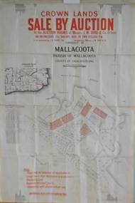
maps, early 1900s
... for farming and residential settlement. Orbost-land-1900s maps posters ...796.1 - Crown Land Sale by auction in the township of Mallacoota on Wednesday January 1920 at 2pm. 796.2 - Snowy River farms , 630 acres of river flat land at Orbost on Wednesday April 28, 1909 at 2.30pm. 796.3 - Famous Orbost Flats - "Important Sale of Snowy River Land" , 900 acres subdivided into 13 choice farms on Wednesday 1st December 1920 at 2.30pm. 796.4 - "Second Great Sale in James' Subdivision", adjoining town of Orbost on 16th May, 1919 at 2pm. 796.5 - "Subdivisional Sale Brooklands Estate", 5 rich Snowy River farms on Wednesday 23rd February at 2.30 at Orbost on account of James Hossack Esq. 796.6 - "Subdivisional sale of Splendid Residence Sites and Handy Small Paddocks" adjoining the progressive town of Orbost on 5th March 1915 at 11am at the rooms of H.James & Co. 796.7 - This is a contract drawing on waxed paper. Crossing near Harbecks Cunninghame Signed and traced N. Anderson 17/11/00. 796.8 - A plan and specification on waxed paper. Shire of Orbost Cunninghame Road - signed by the shire engineer. 796.9 - This is a hand drawn map of Orbost Cunninghame Road, November 1896. 796.10 - This is a hand drawn cross-section of a culvert on the Orbost Cunninghame Road. 796.11 - This is a plan of a culvert on Tabbara Road, 13th January 1899 796.12 - This is a poster for an "Important Subdivisional Sale' for land near Orbost Bridge, on Wednesday 16th March 1921 at the rooms of H. James & Co. These documents are an important part of Orbost history in that they show how the town and surrounding areas were subdivided for farming and residential settlement.A set of twelve maps, plans and land sale posters .orbost-land-1900s maps posters h.james -
 Orbost & District Historical Society
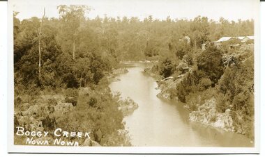
black / white photograph, late 19th - early 29th century
The building in this photograph of Boggy Creek is probably the first Nowa Nowa Hotel built by Moses Faithfull, in 1890. Moses Faithful came to Australia from England with his parents on the Royal Consort in 1844. After living at Bulla, Pakenham and Wurruk he and his wife moved to Hospital Creek in about 1885 where he took up the first selection of land at Upper Hospital Creek. As well as farming he built the first hotel at Nowa Nowa in 1890. He had charge of the hotel until 1895 when he sold to Mary Stirling. Moses died on 8th July 1901, aged 66, at the residence of his son-in-law, David Price, at Newmerella, and buried in the Orbost cemetery.This hotel was built in 1890 and doubled as a coaching stop on the inland route. Settlement grew up around the hotel. It was sold 1895 to Mary Stirling who husband own the land the hotel stood on. The hotel burned down on 29 July 1955. This is a pictorial record of Nowa Nowa in the late 19th century.A black / white photograph / postcard of a creek with a building on the rightside. a windmillis to the left. The banks of the creek are well-vegetated.on front - bottom left -"BOGGY CREEK NOWA NOWA"boggy-creek-nowa-nowa -
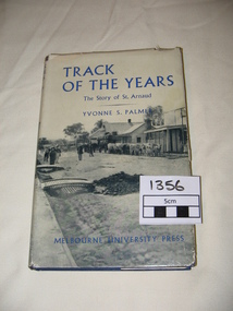 St Arnaud and District Historical Society
Book. Track of the Years, Track Of The Years. The Story of St.Arnaud.By Yvonne S Palmer
TRACK OF THE YEARS. The Story of St.Arnaud by Yvonne S Palmer had aroused local interest when this book was presented in 1955.The fortunes of this prosperous community, whose origins go back to the excitement of of the New Bendigo gold-rush, gleaned from an unusual wealth of reminiscences,diaries, letters, newspapers and photograph albums, are now placed permanently on record in this fascinating narrative. Contents: The New Bendigo Goldrush, Pastoral Settlement, The Aborigines of the Eastern Wimmera, A Permanent Goldrush, The Township Surveyed, Councils at Work 1861- 1870, Local Government in the District. 1861-1870. Sons of the Antipodes, Diggers in Townsmen, Daughters and Wives, Companies and Miners, Mining Settlements, Increasing Needs, Not by Bread Alone, The beginning of Farming, The Changing Countryside, A New St.Arnaud has Come, Deep Sinking and Dividends, Fewer farmers- Larger farms, Pride but not Complacency.Track of The Years by Yvonne S. Palmer. The Story of St.Arnaud. Hardcover book, blue cover with black and white photograph on the dustcover.Includes photographs and maps.308 pages, 1st Edition.1st Edition Published by Melbourne University Press in 1955. 308 pages. -
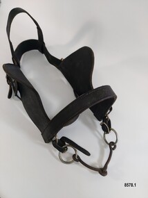 Flagstaff Hill Maritime Museum and Village
Equipment - Horse Harness, Glenn's Leather Goods, Early to mid-20th century
The early settlers of Victoria depended on horse drawn vehicles to farm, make roads and railways, deliver produce and transport people. Horse harnesses were an important requisite for all drivers and could be found wherever there were working horses. Horse Harnesses have played an essential role in different cultures throughout history. Simple, utilitarian horse harnesses made of leather straps and iron rings were being used in early China before AD 500 as well as ancient Greece and Rome allowing horses to pull chariots and ploughs. The Greeks and Romans were the first to use a "horse collar" which distributed the weight of the harness evenly across the horse's chest rather than relying on a "throat harness" that could damage a horse's throat or choke them. During the medieval period, European horse harnesses became more elaborate and decorative. Variations of different horse harnesses were also found in Native American and Middle Eastern cultures. Horse Harnesses usually have four basic components which include - 1. Communication - the bridle, bit and reins allows the driver to communicate instructions and commands to the horse, guiding its movement and direction. 2. Draft - the collar, hame straps, hames, traces and chains enables the horse to draw and pull the load efficiently by distributing the weight and transferring the pulling force to the vehicle. 3. Stopping - the breeching band, pole straps and breast strap helps to control or stabilise the horse and vehicle when moving downhill or stopping. 4. Support - the back pad, backband, belly band and back saddle keep the harness in the correct position and proper alignment. This dray harness is a plain, basic harness and reflects its working class origins. It was used by Mr. Oswald (Jack) Bourke with his horse and dray to firstly deliver drygoods from Sunbury to Melbourne in the 1930's and later (through the 1940's and 1950's up to 1961) when he worked on the garbage round for the Springvale City Council. This horse harness is a significant example of the equipment that was needed wherever horses were being used - particularly in the early years of Victoria's settlement by white settlers. Harnesses such as this example were used with drays, farming equipment, delivery carts and personal transportation.A leather and metal horse harness used with a horse and dray circa 1930's to the early 1960's. It is made up of a number of components. 1. A leather bridle with metal buckles and rings, blinkers and a metal single jointed, snaffle bit that has the initials M B stamped onto the leather. 2. A leather bridle with metal buckles and rings and a metal "straight bar" Eggbut snaffle bit. It has an elongated X design (with 4 dots) stamped onto the leather strap holders near each buckle. 3. A blue and white vinyl halter with one leather patched strap. The nose band and a chin strap are covered with woollen padding. 4. A pair of leather shaft protectors. They have lacing holes along each edge and a repeating design of small shapes (flowers, wings, crosses and arrowheads) which run along the front of each protector. 5. A leather strap with a stainless steel chain and catch and a maker's mark for "Glenn's Leather Goods, Pearcedale Victoria" stamped onto the end. 6. A wide leather strap covered with a webbing sleeve. It has two large metal rings and each end and one ring has a rope attached. 7. A leather strap comprised of three separate sections (two shorter and one longer) joined with two metal rings. The longer section has notches along its length and the shorter section at the other end has a buckle. It also had a maker's mark stamped on it but the mark is very worn and the writing is difficult to read. 8. An adjustable leather horse collar with two buckles and straps at the top opening and two "B's" stamped into the leather. The top of the collar is made from treated leather pieces stitched together and the underneath of the collar is untreated leather. It has a padded indentation running all the way around the collar for the hames to sit in. 9. Two pairs of long leather traces - each having a buckle and notched section at one end and each one is made with three lengths of leather spliced together. 10. A leather strap (with one spliced join) belonging to a horse harness with two shorter straps (each ending with a metal clip) attached to a steel D ring at one end. 11. Three assorted short leather straps - the top one has clips at each end and a buckle (for adjusting the length) in the centre, the middle strap has notches and a buckle and the bottom strap is white with notches and a buckle.Bridle with blinkers - "M B" Bridle - design showing an elongated X with a dot in each section stamped onto strap holder Shaft Protectors - stamped design of flowers, wings, crosses and arrowheads Strap with chain - "Glenn's leather goods / Pearcedale / Victoria" Leather Strap (with two metal rings) - Maker's stamp - "name indecipherable / SADDLER / ...OURNE" Collar - "B / B" Leather strap - flagstaff hill maritime museum and village, warrnambool, great ocean road, sunbury, springvale, dray, delivery dray, harness, horse harness, horse drawn vehicles, working horse, oswald (jack) bourke, bridle, horse collar, hames, shaft protectors -
 Flagstaff Hill Maritime Museum and Village
Equipment - Show Harness, R. Mitchell, Saddler, Early to mid-20th century
The early settlers of Victoria depended on horse drawn vehicles to farm, make roads and railways, deliver produce and transport people. Horse harnesses were an important requisite for all drivers and could be found wherever there were working horses. Horse Harnesses have played an essential role in different cultures throughout history. Simple, utilitarian horse harnesses made of leather straps and iron rings were being used in early China before AD 500 as well as ancient Greece and Rome, allowing horses to pull chariots and ploughs. The Greeks and Romans were the first to use a "horse collar" which distributed the weight of the harness evenly across the horse's chest rather than relying on a "throat harness" that could damage a horse's throat or choke them. During the medieval period, European horse harnesses became more elaborate and decorative. Variations of different horse harnesses were also found in Native American and Middle Eastern cultures. Horse Harnesses usually have four basic components which include - 1. Communication - the bridle, bit and reins allows the driver to communicate instructions and commands to the horse, guiding its movement and direction. 2. Draft - the collar, hame straps, hames, traces and chains enables the horse to draw and pull the load efficiently by distributing the weight and transferring the pulling force to the vehicle. 3. Stopping - the breeching band, pole straps and breast strap helps to control or stabilise the horse and vehicle when moving downhill or stopping. 4. Support - the back pad, backband, belly band and back saddle keep the harness in the correct position and proper alignment. This show harness was used by Mr. Andy Bourke when showing his Clydesdales at shows or demonstrations. Although a more modern example with decorative embellishments, it still has many essential components traditionally found in an everyday working horse harness. The original purpose of the "housen" for example, was to run rain or drizzle off the horse's neck when they had to work in wet conditions - it was laid flat for this purpose on the top of the collar. Nowadays it is purely for show and is often used to advertise a business or stud. Horse brasses and fly terrets were fastened to various parts of a horse's harness. In the early days they probably began as amulets to ward off evil and to bring good luck and continued to be used as a festive decoration. The heyday of horse brasses was between the years 1851 and 1900. Horse brasses are fastened to various parts of the harness with many of their designs being symbolic. The ornamentation on this harness (although not authentic horse brasses) are based on the horse brasses that were popular in the 19th century. This horse harness is a significant example of the equipment that was needed wherever heavy horses were being used - particularly in the early years of Victoria's settlement by white settlers. Harnesses such as this example were used with stage coaches, drays, farming equipment, delivery carts and personal transportation.A leather and metal horse harness used when showing a Clydesdale (or other breed of heavy horse). It is made up of a number of components. 1. Decorative leather cart saddle with two large cloth pads underneath (which have a scalloped leather and stud border), a raised leather pommel and a silver and red coloured metal back strap holder across the top. It has two symmetrical sets of ornamentation (silver hearts and circles) in the front and a wide strap or girth (with a maker's stamp reading "R. Mitchell Saddler") and buckle which attaches the saddle to the horse. 2. Pair of steel hames which are gently curved (to fit on a horse collar) and are topped with steel knobs. They have several steel rings and lugs (to hold straps and chains) and a "Made in England Warranted Steel" stamp. 3. Breeching harness which consists of a number of leather straps, chains and metal rings including a wide padded leather strap with a scalloped edge that sits on the back of the horse and a thick leather strap that goes around the hind quarters of a horse which is joined to the back strap with four shorter vertical straps and buckles. These straps feature silver and red patent leather trim and silver heart shaped ornamentation. The strap also features the maker's stamp of "R. Mitchell". 4. Decorative leather bridle with blinkers featuring the same silver and red patent leather trim on the cheek piece, brow band and throatlatch. It has a stainless steel "Liverpool Driving Bit" with a curb chain, a variety of decorative silver ornaments (rosettes, diamonds plus a heart and two circles) on each end of the forehead band, dropper and strap as well as a silver metal bell (sometimes known as a "fly terret" or "swinger") that sits on the headpiece of the bridle. 5. Leather "violin shaped" dropper (or hanger) with two silver rosette shaped ornaments and a stainless steel clip on the top 6. Stainless steel "Liverpool Driving Bit" with a straight mouthpiece which is ribbed on one side. It has three rein spots (spaces) and a curb chain. 7. Leather arch shaped "Housen" covered in black and red patent leather and decorated with silver studs (some spelling out F H) and bordered with a red fringe. It has a leather strap at the back and two leather loops on the front. 8. Leather padded backband (Australian style "Stallion Draught Roller") decorated with two groups of nine metal "horse brasses" or harness ornaments displaying horseshoe, starburst and horse head designs on blue, red and white striped webbing. The backband has three notched straps at each end, a buckle near the centre and the initial B stamped in two places underneath. 9. Bellyband made of leather and red, white and blue striped webbing. It has a set of three buckles at each end (which correspond with the notched straps of the backband). 10. Wide, thick leather strap which has a buckle and notches at each end. It also has the maker's stamp of "R. Mitchell Saddler". 11.One pair of long leather traces - each with a buckle and notched loop at one end, decorated with a small silver diamond shaped harness ornament. 12. Length of stainless steel heavy duty chain with two swivel connectors.Saddle - "R.MITCHELL / SADDLER" Hames - "MADE IN ENGLAND / WARRANTED / STEEL" "MADE IN ENGLAND / WARRANTED / unclear" Breeching Straps - "R. MITCHELL / MAKER / R. MITCHELL MAKER" Housen - "F H" Backband "B / B' Wide leather strap - "R. MITCHELL / SADDLER"flagstaff hill maritime museum and village, warrnambool, great ocean road, shipwreck coast, harness, horse harness, show harness, clydesdale horses, andy bourke, horse drawn cart, housen, bridle, hames, breeching straps, dropper, bit, liverpool bit, backband, harness ornamentation, bellyband, back saddle, fly terret -
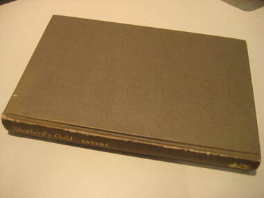 Federation University Historical Collection
Book, C.E. Sayers, Shepherd's Gold: The Story of Stawell, 1966 (exact)
... , Borough, Town, Hospital, schools, Churches, Growth of Settlement..., schools, Churches, Growth of Settlement, Claim Jumps, Sheep ...One of the 6 University of Ballarat campuses is at Stawell.Grey hard covered book of 194 pages covering the history of Stawell, Victoria. Contents include Gold, squatters, Ayreys of Warranooke, Diggings, Reefs, Local Government, Road District, Shire, Borough, Town, Hospital, schools, Churches, Growth of Settlement, Claim Jumps, Sheep, Farming, Water, Grampians, Magdala, Callawadda, Deap Lead, Glenorchi, Great Western, Green's Creek, Marnoo, Wal Wal.education, religion, stawell victoria, stawell -
Federation University Historical Collection
Book, The Pyreness Shire, Avoca Shire Heritage Study 1864-1994, Volume 1, 1995
The Pyreness Shire, Avoca Shire Heritage Study 1864-1994, Volume 11) 21008.1 - Volume 1 - Pale blue bound book of 47 pages - Environmental History 2) 21008.2 - Volume 3 - Pale blue bound book - Geographical Locations of Individual Sites, alphabetically by Road Namewendy jacobs, karen twigg, nigel lewis/richard aitken pty ltd, shire of avoca, avoca heritage study, national estate committee (victoria), national estate grants program, victorian goldfields, pyrenees, moonambel, natte yallock, rathscar, barkly, redbank, crowlands, landsborough, the pyrenees shire, lexton shire, exploration and pastoralism, gold, water, farming, wine and fruit, towns and settlements, living in community, road and rail, extractive industries, conclusion, ballarat, major mitchell, djadja wurrung aboriginal group, djab wurrung aboriginal group, avoca, lamplough, chinese camp, alluvial mining, ironbark mine, upper homebush, homebush deep lead mine, avoca and district historical society, deep leads, quartz mining, percydale, hog's reef mine, avoca, dredging, hunter's home, moonambel c. 1890, mrs ellen allan, lamplough, the 1865 land act, flour milling, flour mill, moonambel. c. 1880, harkins farm, bung bong c. 1900, dairying, viticulture, navarre, schools, churches, cemetaries, wars, hotels, halls, sports, horse racing, country fire authority, maryborough-avoca railway, cobb and co -
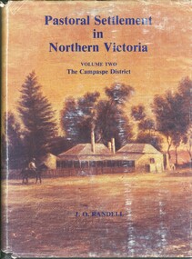
 Bendigo Historical Society Inc.
Book - PASTORAL SETTLEMENT IN NORTHERN VICTORIA - VOL 1. THE COLIBAN DISTRICT, 1979
... HISTORY Agriculture northern victoria - coliban farming ...Pastoral Settlement in Northern Victoria, volume 1, the Coliban District. 353 pages with illustrations, photographs and maps.J.O. Randellhistory, agriculture, northern victoria - coliban, farming, agriculture, pastoral settlement, stations, runs -
 Bendigo Historical Society Inc.
Book - PASTORAL SETTLEMENT IN NORTHERN VICTORIA VOLUME TWO CAMPASPE DISTRICT
Book: PASTORAL SETTLEMENT IN NORTHERN VICTORIA VOLUME TWO CAMPASPE DISTRICT - 602 pages with photos, illustrations, and pull out maps. History of stations and runs in the region.J.O. Randellhistory, agriculture, northern victoria - campaspe, farming, pastoral life, farming life, northern victoria. agriculture -
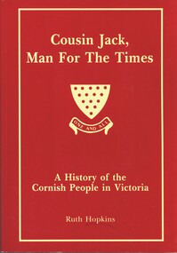 Bendigo Historical Society Inc.
Book - COUSIN JACK MAN FOR THE TIMES, 1994
Cousin Jack, Man for the Times. A history of the Cornish People in Victoria. Between the pages is a short page of notes written by Alex Stone, listing topics and page numbers at which these topics maybe found.Ruth Hopkinsvictoria, history, cornish people, settlement in victoria, industry and manufacture, farming, etc. -
 Bendigo Historical Society Inc.
Book - KIMBOLTON, 1976
... early farming settlement... HISTORY Australian early farming settlement Farming history. John ...Kimbolton. History of a Victorian sheep station from its first settlement in 1838.John Ormond Randellhistory, australian, early farming settlement, farming history. -
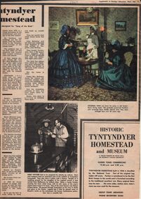 Bendigo Historical Society Inc.
Newspaper - LYDIA CHANCELLOR COLLECTION: TYNTYNDYER HOMESTEAD
... early farming settlement... HISTORY Australian early farming settlement Lydia Chancellor ...An article from a 'Supplement to Bendigo Advertiser' giving some insights into the history of Tyntyndyer Homestead which is in the Swan Hill district. It gives an insight into the early settlers and their struggles for survival. There is an advertisement within the supplement advertising the 'Historic Tyntyndyer Homestead and Museum.' Coloured and black and white photographs are included in this article which is dated 12/2/1969.history, australian, early farming settlement, lydia chancellor collection, collection, swan hill, aboriginal, aboriginal contact, australia, history, australian history, homesteads, building, house, houses, heritage, tourism, aborigines, settlers, weapons, guns, pastoralists, expedition, john holloway, andrew beveridge, peter beveridge, robert o'hara burke, narrinyeri tribe, bushrangers, relics, national trust, advertisement, exploration -
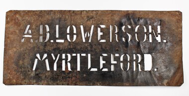 Myrtleford and District Historical Society
Tobacco bale stencil
Stencil used by Sgt. Albert David Lowerson, VC, a soldier settler on Merriang Estate near Myrtleford. Lowerson acquired one of 19 blocks assigned by the Closer Settlement Board on the 700 acre estate in 1920. The stencil marked bales of cured tobacco leaves prior to shipment to Melbourne. Lowerson was one of the few successful soldier settler farmers in the district, operating a piggery, dairy farming and growing tobacco for almost 20 years on "St. Quentin". (Lowerson was awarded the Victoria Cross at Mont St. Quentin on September 1, 1918.) His success and status enabled him to lead a submission on farm debt and infrastructure problems when the soldier settlement scheme was being reviewed at government level. He was active locally on these issues and supported fund raising for a war memorial, memorial hall and veteran welfare.The stencil represents the achievements of A.D.Lowerson, VC as an isolated example of success as a WW1 soldier settler and as a local identity who stridently supported the need for recognition and support of ex-service personnel.Stencil made of thin sheet metal, rusted .Wording of stencil "A.D.LOWERSON. MYRTLEFORD." lowerson a.d., merriang estate, myrtleford, closer settlement board, tobacco, st. quentin, victoria cross, world war 1 -
Tatura Irrigation & Wartime Camps Museum
Photographs, Anderson collection of irrigation and farm photos, c.1920 (Loaned), c.1920
Collection of photos taken c.1920 by the Anderson family. Carlton and Bill Anderson left Murchison for a soldier settlement block at North West Mooroopna, 2 miles from the school. Bill had been a stretcher bearer in WW1. Photos taken by Anderson family of general farming activities, irrigation channel construction with horse teams, Goulburn Weir, Waranga Basin western outlet structure and channel, official opening ceremony. Photos loaned for copying.|1. Outlet structure, possibly the opening.|2.Western Channel.|3.Waranga Basin inlet.|4. Waranga Basin outlet.|5,6.Goulburn Weir.|7,8 Channel construction with horse teams.|9.Skid scoop.|10. Group at Bain.|11."Spot", Bill Anderson and the team.|12.Teams take time off.|13.Washing up.|14.Spring cart and "Smoko"|15.Bill Anderson holding horse.|16.Team of four.|17.A good crop.|18.Wonkey scoop with two horse team.|19,Horses at rest.|20.Head in nose bag.|21.Bill Anderson & Marty Clooney, tents, wagons and gig.|22.Wally Wybrow grooming horse.|23 Bill Anderson, Marty Clooney and furphy tank.|24. Four horse teams.|25.Carlton Anderson? cutting hair.|26,27.|28.Three wheel trolley made from old harvester.|29. Harvester.|30.Wally.|31.Marty Clooney and horse.|32|33.Seven horse team.|34-43.Various farm photos -
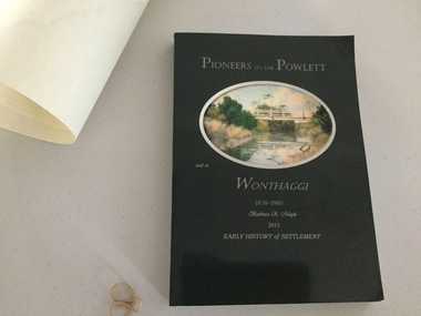 Wonthaggi & District Historical Society
Book and Map, Barbara Moyle, Pioneers on tthe Powlett and at Wonthaggi 1878-1910, 2015
Book - families social histories, maps, photograps Map - block numbers town names physical / geographical featuresFarming and social history of pioneers of the Powlett River are prior to the establishment of the State Coal Mine at Wonthaggi. Significant land marks, buildings and photographs are included. Dark green cover with oval artists impression of Powlett river and bridge Associated map which covers the parishes plus key places of interestlPioneers on the Powlett and at Wonthaggi 1878-1910 Barbara R Moyle 2015 Early History of Settlement Map - Parish names, significant sitesfarming, pioneers of wonthaggi and district, wonthaggi families -
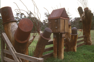 Nillumbik Shire Council
Sculpture: Tony Trembath (b.1946 Sale, Victoria), Tony Trembath, The Fences Act 1968 - Location: Edendale Farm (entrance) 30 Gastons Road, Eltham, 1989 - 1994
Eltham Council (now the Shire of Nillumbik) commissioned this work in 1989 to create an entrance / gateway to Edendale Community Farm. It was also aided by a grant from the Ministry of the Arts (now Arts Victoria). The former name of this work was "Gateway to Edendale Farm". Edendale Farm is a demonstration farm modelling sustainable environmental practices, providing support to the local residents of Nillumbik. Established in 1986, the land was purchased in 1970. It was previously an English gentleman's residence and was used for grazing. It consists of 5.6 hectares, with the Diamond Creek meandering through the property. The Victorian Fences Act 1968 governs liability of occupiers of adjoining lands to fence, and deals with disputes between neighbours regarding boundaries fences and costs. This work took into consideration ideas and suggestions from residents and committees, who required the use of recycled materials and that the work celebrate man's relationship with nature, animals and the earth, as well as relate to the fence-line on the far side of the carpark. Trembath also absorbed significant aspects of local history, making references to Eltham's agricultural past, the clearing of the land, the destruction of trees, the ruthless pruning of trees by suburban Councils and incorporated such Australian features as the post and rail fence. 'The Fences Act 1968' is significant for aesthetic, historic and social reasons at a regional level. It makes prominent the historical and social significance of Edendale and the rural aspects of Nillumbik. The use of existing tree stumps and salt pots in the work explores the iconography of the countryside such as the isolated farmhouse, pioneering farming practices, post and rail fencing and the regrowth of lopped trees. The title of the work, as well as the extensive community involvement in its creation, also makes reference to the Victorian Fences Act 1968, which makes neighbours jointly responsible for the cost of construction and maintenance of fences in the partitioning of land for settlement. 'The Fences Act 1968' has been classified as of regional significance by the National Trust of Australia. The work is an installation of wood and metal, approximately twenty five meters long. The design is very informal and rustic and runs the full width of the fence-line. It comprises groups of recycled tree trunks fitted with metal caps (chrome-nickel 'salt pots' that are shaped like tall bowler / top hats). Metal rods protrude from the trunks and some of these rods have metal birds. Two larger, sentinel-like stumps at the two outer ends have metal flame-like wings, which bend inward. To the left of the entrance, a simple architectural element indicates an isolated farmhouse. The rustic fence runs between the groups of tree trunks with native planting in clumps along it. The fence-line incorporates a functional engineered double gate and post and rail fencing. There may be many interpretations of the work and the intention is to stimulate interest and imagination rather than alienate. Interpretation is based on the personal experience that a visitor brings. The artist recommended that no explanation of the design logic be positioned with the work. N/Apublic art, sculpture, edendale, recycled, wood, metal, fences act 1968, gate, trembath, salt pot, tree stumps -
National Wool Museum
Book, Sand Castles
... Pastoral Industry - settlement Farming..." - Michael Elliott, 1990. Pastoral Industry - settlement Farming ..."Sand Castles: the story of the development of Naranga in the Coonalpyn Downs district of South Australia" - Michael Elliott, 1990.pastoral industry - settlement farming, elliott and dibb, 'naranga', south australia, pastoral industry - settlement, farming -
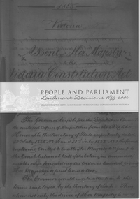 Whitehorse Historical Society Inc.
Pamphlet, Barnard, Jill and Jennings Sonia, People and Parliament, 2006
... Land Settlement Farming Water Gardening Land use A 24 page ...A 24 page booklet of landmark decisions by the Victorian Government between 1855 - 2006 was published to celebrate their 150th anniversary.24 pp, A4non-fictionA 24 page booklet of landmark decisions by the Victorian Government between 1855 - 2006 was published to celebrate their 150th anniversary. aborigines, coranderrk, victorian government, suffrage, land settlement, farming, water, gardening, land use -
 Ballarat Heritage Services
Photograph - Digital photograph, Dorothy Wickham, Winter's Swamp, Ballarat, January to April 2014
Study of Winter's Swamp commissioned by BEN and completed by BHS. The swamp was named after one of the first European settlers in the district. Winter Swamp LAT -37 32 LONG 143 47, Parish of Dowling Forest, County of Grenville Winter Swamp, on the southwest corner of Ballarat West Town Common, was not included in the original proclamation of the Common in 1861. However, being marshland, it was not considered suitable for grazing, so was added to the Common soon after 1861. Winter Swamp is a large wetland with native and exotic pasture significant for wildlife. John Winter (Jock) was born in Berwickshire, Scotland. He married Janet Margaret Irving the daughter of Robert Irving, advocate, Bonshaw, Dumfries, Scotland. Winter died in Ballarat in 1875 and was buried at the Ballaarat Old Cemetery. He took up the run Bonshaw from 1841; Leigh River Buninyong 1842-46; Junction, Delatite, March 1851 to September 1862; with sons: Carag Carag and Corop, April 1857 to September 1872; Colbinabbin and Stewart’s Plains, April 1857 to December 1872; St Germains February 1867 to March 1871. (The name became Winter-Irving in 1890). Mr John Winter, who died on August 22 at the age of 72, was a man of some note it the mining community of Ballarat. He was a self-made man, and one of our oldest colonists, it being over a quarter of a century age since he took up county about Ballarat and settled at Bonshaw. He died very rich. It is calculated that if he had retained an interest in all his runs, his income must have been not less than £10,000 or £50,000 a year. Some eight or ten years ago he sold his Bonshaw pre-emption to the Bonshaw Gold mining Company for £20,000, and a few years later the ground belonging now to Winter's Freehold Company brought him £50,000 more, the payment being made at the requisition of the deceased in sovereigns. In these relations Mr. Winter has been closely identified with the mining industry at Ballarat. The deceased was a native of Lauder, in Berwickshire, and landed in Victoria several years before the gold discovery.The principle task of this project was the delivery of a report outlining the history of European settlement in the Skipton and Cardigan/Ballarat districts as pertinent to the use of and impact on the natural environment of the two reserves Skipton Common and Winter Swamp. The report was delivered in digital form only. The report, upon completion, was presented to the Network’s Committee in order to discuss the project. The report identified and described the uses of Skipton Common and Winter Swamp, and their impacts. In particular, this report examined farming/grazing (official and informal), mining, vegetation removal (including the removal of woodlands for timber, grasslands for pasture improvement) & use of riparian areas for access to water and timber removal. Recording the more benign and environmentally friendly uses such as picnicking, community activities, nature walks and the roles of organisations such as Field Naturalists’ and Bird Observers’ clubs, school and scout/guide groups will be relevant in helping to depict overall community attitudes towards the reserves; e.g.: has the Common generally been viewed as little more than a grazing paddock and fire hazard; has Winter Swamp always been the unknown natural asset that seems to have been its lot for at least the past 40 years? In this regard, the more contemporary history of actions surrounding the use and management of the reserves is of particular interest, in view of the extant evidence at both reserves; e.g. the actions of the Shire of Ballarat in the 1980s in establishing Winter Swamp as something of a competitor to Lake Wendouree but with a more environmental bent (although almost none of the plants used are indigenous species, but that is part of the story); the trotting track constructed on Skipton Common in the 1960s following representations to Premier Henry Bolte and the cropping of the western section of the Common to raise funds for the town’s new swimming pool, the fertilizing of the land putting an end to the native grassland vegetation. There are obviously multiple sources of information to source in preparing the report, however sources that the contractor is specifically requested to consult are the Skipton Historical Society, the former Skipton Common managers (specifically Graeme Pett), the Cardigan Windermere Landcare Group and the Learmonth Historical Society (believed to hold many of the former Shire of Ballarat’s records pertaining to the Council’s role as the Committee of Management for both Winter Swamp and the Ballarat West Town Common – Winter Swamp was split between 2 separate Crown Land tenures). The contractor is also encouraged but not required to utilise community newsletters, such as the Skipton Community Newsletter, to publicise and seek information about the project. Skipton Historical Society (Mary Bradshaw) contacted on Thursday 12 June 2.30pm. Mary lived on a farm out of Skipton but is currently living in the township. She remembers walking along the creek of the Common especially in spring and autumn in bare feet and that it was a very pretty place. There were a few snakes around the waterway in summer. People put cows and a couple of horses on the commonage to graze. Graeme Pett has always lived close to the Common and would know a lot about it. Other possible contacts would be Nicole Petress, Secretary of the Progress Association, and the Corangamite Council, Camperdown. Digital images of Winter's Swampwinter's swamp, ballarat, john winter, ballarat environmental network, mullawullah -
 Ballarat Heritage Services
Photograph - Digital photograph, Winter's Swamp surrounds, April 2014
The swamp was named after John (Jock) Winter. John Winter (Jock) was born in Berwickshire, Scotland. He married Janet Margaret Irving the daughter of Robert Irving, advocate, Bonshaw, Dumfries, Scotland. Winter died in Ballarat in 1875 and was buried at the Ballaarat Old Cemetery. He took up the run Bonshaw from 1841; Leigh River Buninyong 1842-46; Junction, Delatite, March 1851 to September 1862; with sons: Carag Carag and Corop, April 1857 to September 1872; Colbinabbin and Stewart’s Plains, April 1857 to December 1872; St Germains February 1867 to March 1871. (The name became Winter-Irving in 1890). Mr John Winter, who died on August 22 at the age of 72, was a man of some note it the mining community of Ballarat. He was a self-made man, and one of our oldest colonists, it being over a quarter of a century age since he took up county about Ballarat and settled at Bonshaw. He died very rich. It is calculated that if he had retained an interest in all his runs, his income must have been not less than £10,000 or £50,000 a year. Some eight or ten years ago he sold his Bonshaw pre-emption to the Bonshaw Gold mining Company for £20,000, and a few years later the ground belonging now to Winter's Freehold Company brought him £50,000 more, the payment being made at the requisition of the deceased in sovereigns. In these relations Mr. Winter has been closely identified with the mining industry at Ballarat. The deceased was a native of Lauder, in Berwickshire, and landed in Victoria several years before the gold discovery. BHS were commissioned by Ballarat Environment Network for a project on Winter's Swamp and Skipton Common. Winter's Swamp was part of Ballarat West Common. The principle task of this project was the delivery of a report outlining the history of European settlement in the Skipton and Cardigan/Ballarat districts as pertinent to the use of and impact on the natural environment of the two reserves Skipton Common and Winter Swamp. The report was delivered in digital form only. The report, upon completion, was presented to the Network’s Committee in order to discuss the project. The report identified and described the uses of Skipton Common and Winter Swamp, and their impacts. In particular, this report examined farming/grazing (official and informal), mining, vegetation removal (including the removal of woodlands for timber, grasslands for pasture improvement) & use of riparian areas for access to water and timber removal. Recording the more benign and environmentally friendly uses such as picnicking, community activities, nature walks and the roles of organisations such as Field Naturalists’ and Bird Observers’ clubs, school and scout/guide groups will be relevant in helping to depict overall community attitudes towards the reserves; e.g.: has the Common generally been viewed as little more than a grazing paddock and fire hazard; has Winter Swamp always been the unknown natural asset that seems to have been its lot for at least the past 40 years? In this regard, the more contemporary history of actions surrounding the use and management of the reserves is of particular interest, in view of the extant evidence at both reserves; e.g. the actions of the Shire of Ballarat in the 1980s in establishing Winter Swamp as something of a competitor to Lake Wendouree but with a more environmental bent (although almost none of the plants used are indigenous species, but that is part of the story); the trotting track constructed on Skipton Common in the 1960s following representations to Premier Henry Bolte and the cropping of the western section of the Common to raise funds for the town’s new swimming pool, the fertilizing of the land putting an end to the native grassland vegetation. There are obviously multiple sources of information to source in preparing the report, however sources that the contractor is specifically requested to consult are the Skipton Historical Society, the former Skipton Common managers (specifically Graeme Pett), the Cardigan Windermere Landcare Group and the Learmonth Historical Society (believed to hold many of the former Shire of Ballarat’s records pertaining to the Council’s role as the Committee of Management for both Winter Swamp and the Ballarat West Town Common – Winter Swamp was split between 2 separate Crown Land tenures). The contractor is also encouraged but not required to utilise community newsletters, such as the Skipton Community Newsletter, to publicise and seek information about the project. Skipton Historical Society (Mary Bradshaw) contacted on Thursday 12 June 2.30pm. Mary lived on a farm out of Skipton but is currently living in the township. She remembers walking along the creek of the Common especially in spring and autumn in bare feet and that it was a very pretty place. There were a few snakes around the waterway in summer. People put cows and a couple of horses on the commonage to graze. Graeme Pett has always lived close to the Common and would know a lot about it. Other possible contacts would be Nicole Petress, Secretary of the Progress Association, and the Corangamite Council, Camperdown. Mary can’t remember any photos in the Skipton Historical Society that pertain to the Common. Digital photos of Winter's swamp surrounds, later known as Mullawullah.winter, winter's swamp surrounds, winter's swap, john winter, ballarat environmental network, ballarat, mullawullah -
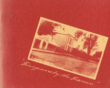 Otway Districts Historical Society
Book, Birregurra Hall Committee, Birregurra by the Barwon
A history of Birregurra from the first settlement of Bunting Dale Mission Station in 1839 to the present.Birregurra by the Barwon. Fiona Henderson (ed.). 1st ed. Birregurra Hall Committee; Birregurra (Vic); nd. i, 60 p.; illus, maps. Soft cover.birregurra; barwon river; history; bunting dale; bowens point; farming; explorers; settlers; -
 Bendigo Historical Society Inc.
Newspaper - Newspaper articles - North Central Loddon Region
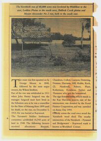
8375a: The Victorian soldier settlement scheme created in 1917 to lease farming land to soldiers and nurses returning from WW1. The Scheme was heavily criticised. Some reasons for this were the settlers' lack of capital, the size of the land allocated, and the prices of agricultural products both purchased and sold by the farmers. In the wake of WW2, the soldier settlement scheme was refined and, under the supervision of the Soldier Settlement Commission, was re-established. The Yarraberb Settlement was one of the settlements established in 1948. 8375b: Archibald Edmund "Archie" Robertson was born in Eaglehawk in 1884 to Martin Robertson and Anna Margaretha/Hannah Marguerita (nee. Weseloh/Wesloah). Robertson was a commissioned officer during WW1 and contributed to the welfare and advancement of the California Gully community. Following his death in 1922, following a fall from his bike, the community honoured Robertson with a memorial seat in 1923.A3 colour photocopies of newspaper articles pertaining to the North Central Victoria Region. Date of photocopy unknown. Location of original paper unknown (likely the Eaglehawk Times, unable to confirm). Both articles were cut from a larger paper. Article 8375a briefly describes the Yarraberb Solider Settlement. Article 8375b recounts the dedication of Archie Robertson's seat in California Gully. newspaper, eaglehawk heritage society, yarraberb soldiers settlement, soldier settlement commission, archie robertson, california gully, ww1, ww2 -
 Kew Historical Society Inc
Photograph - Flooding of the Yarra River in North Kew, 1934
North Kew, now divided between Kew and Kew East, bordered the Yarra River. As such, it was a region subject to flooding in the Yarra Valley. Development beyond this point (ie Kellett Grove) was limited by the City of Kew's planning regulations. Prior to urban development, the area since European settlement and the first land sales in the district in the 1840s, had been used for dairy farming. Small sepia snapshot taken from the river ramp of a house at 8 Kellett Grove, in what was then known as North Kew. The point of view is from a backyard looking towards Fairfield. Beyond the fence line are two almost submerged houses. A number of people are in a motor driven boat midstream. Fairfield at this period, (ie 1934) was noted for its limited river side development. Verso: 2/12/34 / TAKEN FROM OUR RAMPyarra river -- north kew, floods -- yarra valley, floods -- north kew, floods -- 1929, floods -- 1934, natural disasters -- kew