Showing 360 items matching "glenferrie street"
-
 Kew Historical Society Inc
Functional object - Wrought iron nails from 'Reno', St John's Parade, c. 1864
... , Glenferrie Road, Wellington Street, and Charles Street. The southern..., Glenferrie Road, Wellington Street, and Charles Street. The southern ...Comparatively few weatherboard houses in Kew survived from the early years of settlement into the second half of the 20th century. One such property was ‘Reno’, which once stood on the east side of St John’s Parade. Its earliest recorded owner was the architect Samuel Cocking who lived there from c.1865 until his death in 1888. The original landholding was bordered by Cotham Road, Glenferrie Road, Wellington Street, and Charles Street. The southern portion of this land included a fine orchard, with many imported trees. The old summer house, at first in the orchard, was later removed to the house garden. The MMBW Detail Plan No.1576 (1904) shows the remaining portion of the original land holding, including a semi-circular pathway at the front, and garden features such as an aviary, a fountain and grotto, and a fernery. None of these are apparent in photographs dating from the 1960s, where the garden, which once included rare plants provided by Baron Von Mueller, surrounds the cottage in a tangled frenzy. Despite a ‘local significance’ classification by the National Trust, the house was demolished in 1977.7 square headed iron nails collected from Reno before its demolition. In envelope marked with the name Joy Stewartreno, nails, samuel cocking -
![Wallpaper from 'Reno', St John's Parade [Kew]](/media/collectors/550653872162f11fb04854aa/items/57975996d0cdd1098c81d980/item-media/579759ded0cdd1098c81f6fa/item-fit-380x285.jpg) Kew Historical Society Inc
Kew Historical Society IncDecorative object - Wallpaper sample from 'Reno', St John's Parade, 1890s
... , Glenferrie Road, Wellington Street, and Charles Street. The southern..., Glenferrie Road, Wellington Street, and Charles Street. The southern ...Comparatively few weatherboard houses in Kew survived from the early years of settlement into the second half of the 20th century. One such property was ‘Reno’, which once stood on the east side of St John’s Parade. Its earliest recorded owner was the architect Samuel Cocking who lived there from c.1865 until his death in 1888. The original landholding was bordered by Cotham Road, Glenferrie Road, Wellington Street, and Charles Street. The southern portion of this land included a fine orchard, with many imported trees. The old summer house, at first in the orchard, was later removed to the house garden. The MMBW Detail Plan No.1576 (1904) shows the remaining portion of the original land holding, including a semi-circular pathway at the front, and garden features such as an aviary, a fountain and grotto, and a fernery. None of these are apparent in photographs dating from the 1960s, where the garden, which once included rare plants provided by Baron Von Mueller, surrounds the cottage in a tangled frenzy. Despite a ‘local significance’ classification by the National Trust, the house was demolished in 1977. Wallpaper fragment from ‘Reno’. This small fragment of floral wall paper is a bolder design than the delicately drawn flowers in 1977.0005.1. The flowers in this example were impressionistically created using printing blocks that allowed for different thicknesses of paint to be applied in the hand-blocking process. wallpaper, reno, st john's parade, kew -
![Wallpaper from 'Reno', St John's Parade [Kew]](/media/collectors/550653872162f11fb04854aa/items/57975a62d0cdd1098c8232a8/item-media/57975cabd0cdd1098c836f91/item-fit-380x285.jpg) Kew Historical Society Inc
Kew Historical Society IncDecorative object - Wallpaper sample from 'Reno', St John's Parade, 1870s
... , Glenferrie Road, Wellington Street, and Charles Street. The southern..., Glenferrie Road, Wellington Street, and Charles Street. The southern ...Comparatively few weatherboard houses in Kew survived from the early years of settlement into the second half of the 20th century. One such property was ‘Reno’, which once stood on the east side of St John’s Parade. Its earliest recorded owner was the architect Samuel Cocking who lived there from c.1865 until his death in 1888. The original landholding was bordered by Cotham Road, Glenferrie Road, Wellington Street, and Charles Street. The southern portion of this land included a fine orchard, with many imported trees. The old summer house, at first in the orchard, was later removed to the house garden. The MMBW Detail Plan No.1576 (1904) shows the remaining portion of the original land holding, including a semi-circular pathway at the front, and garden features such as an aviary, a fountain and grotto, and a fernery. None of these are apparent in photographs dating from the 1960s, where the garden, which once included rare plants provided by Baron Von Mueller, surrounds the cottage in a tangled frenzy. Despite a ‘local significance’ classification by the National Trust, the house was demolished in 1977.Wallpaper fragment from ‘Reno’. This large single example is interesting as it represents a change in fashion and style from the finely drawn flowers (1971.0002.1) of an older paper, parts of which can be seen behind this sample. Typically the updating of wallpapers was accomplished by laying a new paper over the old. The ‘newer’ wallpaper is of a single colour, the tone of which may have suffered from colour distortion due to ageing. The new block-printed design, featuring repeated sprays of flowers and leaves combines a bold use of colour with an elegance of design.reno, st john's parade, kew, samuel cocking, wallpaper -
![Wallpaper fragment - Reno, St John's Parade [Kew]](/media/collectors/550653872162f11fb04854aa/items/57975cd6d0cdd1098c838ddb/item-media/57975d42d0cdd1098c83c222/item-fit-380x285.jpg) Kew Historical Society Inc
Kew Historical Society IncDecorative object - Wallpaper sample from 'Reno', St John's Parade, 1870s
... , Glenferrie Road, Wellington Street, and Charles Street. The southern..., Glenferrie Road, Wellington Street, and Charles Street. The southern ...Comparatively few weatherboard houses in Kew survived from the early years of settlement into the second half of the 20th century. One such property was ‘Reno’, which once stood on the east side of St John’s Parade. Its earliest recorded owner was the architect Samuel Cocking who lived there from c.1865 until his death in 1888. The original landholding was bordered by Cotham Road, Glenferrie Road, Wellington Street, and Charles Street. The southern portion of this land included a fine orchard, with many imported trees. The old summer house, at first in the orchard, was later removed to the house garden. The MMBW Detail Plan No.1576 (1904) shows the remaining portion of the original land holding, including a semi-circular pathway at the front, and garden features such as an aviary, a fountain and grotto, and a fernery. None of these are apparent in photographs dating from the 1960s, where the garden, which once included rare plants provided by Baron Von Mueller, surrounds the cottage in a tangled frenzy. Despite a ‘local significance’ classification by the National Trust, the house was demolished in 1977. Wallpaper fragment from ‘Reno’. These three boldly designed samples from a single room are in shades of green and brown, highlighted by yellow and red floral sprays. While more accurately printed and coloured, the fragment lacks the freedom of design of the earlier samples.wallpaper, reno, st john's parade, kew, samuel cocking -
![Reno, St John's Parade [Kew] - Reno, St John's Parade [Kew]](/media/collectors/550653872162f11fb04854aa/items/57975dcbd0cdd1098c840aaf/item-media/57975e31d0cdd1098c84343d/item-fit-380x285.jpg) Kew Historical Society Inc
Kew Historical Society IncDecorative object - Wallpaper samples from 'Reno', St John's Parade, 1880-1910
... , Glenferrie Road, Wellington Street, and Charles Street. The southern..., Glenferrie Road, Wellington Street, and Charles Street. The southern ...Comparatively few weatherboard houses in Kew survived from the early years of settlement into the second half of the 20th century. One such property was ‘Reno’, which once stood on the east side of St John’s Parade. Its earliest recorded owner was the architect Samuel Cocking who lived there from c.1865 until his death in 1888. The original landholding was bordered by Cotham Road, Glenferrie Road, Wellington Street, and Charles Street. The southern portion of this land included a fine orchard, with many imported trees. The old summer house, at first in the orchard, was later removed to the house garden. The MMBW Detail Plan No.1576 (1904) shows the remaining portion of the original land holding, including a semi-circular pathway at the front, and garden features such as an aviary, a fountain and grotto, and a fernery. None of these are apparent in photographs dating from the 1960s, where the garden, which once included rare plants provided by Baron Von Mueller, surrounds the cottage in a tangled frenzy. Despite a ‘local significance’ classification by the National Trust, the house was demolished in 1977.Wallpaper fragment from ‘Reno’. These two large fragments of wallpaper have a formality of design that is accentuated by the wide borders and narrow vertical lines that separate the repeated designs of rose garlands in vases on a vertical trellis design. The design is in tones of pink and green with gilding.reno, st john's parade, kew, samuel cocking, wallpaper -
![Wallpaper from 'Reno', St John's Parade [Kew]](/media/collectors/550653872162f11fb04854aa/items/57975eabd0cdd1098c846619/item-media/57975ee7d0cdd1098c8484f7/item-fit-380x285.jpg) Kew Historical Society Inc
Kew Historical Society IncDecorative object - Wallpaper samples from 'Reno', St John's Parade, 1880-1914
... , Glenferrie Road, Wellington Street, and Charles Street. The southern..., Glenferrie Road, Wellington Street, and Charles Street. The southern ...Comparatively few weatherboard houses in Kew survived from the early years of settlement into the second half of the 20th century. One such property was ‘Reno’, which once stood on the east side of St John’s Parade. Its earliest recorded owner was the architect Samuel Cocking who lived there from c.1865 until his death in 1888. The original landholding was bordered by Cotham Road, Glenferrie Road, Wellington Street, and Charles Street. The southern portion of this land included a fine orchard, with many imported trees. The old summer house, at first in the orchard, was later removed to the house garden. The MMBW Detail Plan No.1576 (1904) shows the remaining portion of the original land holding, including a semi-circular pathway at the front, and garden features such as an aviary, a fountain and grotto, and a fernery. None of these are apparent in photographs dating from the 1960s, where the garden, which once included rare plants provided by Baron Von Mueller, surrounds the cottage in a tangled frenzy. Despite a ‘local significance’ classification by the National Trust, the house was demolished in 1977. Wallpaper fragment from ‘Reno’. This small fragment is part of the larger design shown in the previous sample (1971.0002.5). It includes a detail of the trellis element from the larger scheme.wallpaper, samuel cocking, reno, st john's parade, kew -
![Letter Plate, 'Reno', St John's Parade [Kew]](/media/collectors/550653872162f11fb04854aa/items/57a03863d0cdd1210435bac1/item-media/57a038b1d0cdd1210435f155/item-fit-380x285.jpg) Kew Historical Society Inc
Kew Historical Society IncFunctional object - Letter Plate, 'Reno', St John's Parade, c.1900
... , Glenferrie Road, Wellington Street, and Charles Street. The southern..., Glenferrie Road, Wellington Street, and Charles Street. The southern ...Comparatively few weatherboard houses in Kew survived from the early years of settlement into the second half of the 20th century. One such property was ‘Reno’, which once stood on the east side of St John’s Parade. Its earliest recorded owner was the architect Samuel Cocking who lived there from c.1865 until his death in 1888. The original landholding was bordered by Cotham Road, Glenferrie Road, Wellington Street, and Charles Street. The southern portion of this land included a fine orchard, with many imported trees. The old summer house, at first in the orchard, was later removed to the house garden. The MMBW Detail Plan No.1576 (1904) shows the remaining portion of the original land holding, including a semi-circular pathway at the front, and garden features such as an aviary, a fountain and grotto, and a fernery. None of these are apparent in photographs dating from the 1960s, where the garden, which once included rare plants provided by Baron Von Mueller, surrounds the cottage in a tangled frenzy. Despite a ‘local significance’ classification by the National Trust, the house was demolished in 1977.Brass letter plate, originally from the front door of Reno in St John's Parade, Kew. Donated by Miss McDowell in 1977, in the year the house was demolished.reno, st john's parade, kew -
![Wallpaper sample from 'Reno', St John's Parade [Kew]](/media/collectors/550653872162f11fb04854aa/items/5670dfde2162f10b54fac48a/item-media/5797600bd0cdd1098c854c29/item-fit-380x285.jpg) Kew Historical Society Inc
Kew Historical Society IncDecorative object - Wallpaper sample from 'Reno', St John's Parade, 1850-1880
... , Glenferrie Road, Wellington Street, and Charles Street. The southern..., Glenferrie Road, Wellington Street, and Charles Street. The southern ...Comparatively few weatherboard houses in Kew survived from the early years of settlement into the second half of the 20th century. One such property was ‘Reno’, which once stood on the east side of St John’s Parade. Its earliest recorded owner was the architect Samuel Cocking who lived there from c.1865 until his death in 1888. The original landholding was bordered by Cotham Road, Glenferrie Road, Wellington Street, and Charles Street. The southern portion of this land included a fine orchard, with many imported trees. The old summer house, at first in the orchard, was later removed to the house garden. The MMBW Detail Plan No.1576 (1904) shows the remaining portion of the original land holding, including a semi-circular pathway at the front, and garden features such as an aviary, a fountain and grotto, and a fernery. None of these are apparent in photographs dating from the 1960s, where the garden, which once included rare plants provided by Baron Von Mueller, surrounds the cottage in a tangled frenzy. Despite a ‘local significance’ classification by the National Trust, the house was demolished in 1977.Original sample of nineteenth century wallpaper from one of the earliest homes in Kew (Victoria).Wallpaper fragment from ‘Reno’. These two samples of light brown Victorian-period wallpaper were overprinted with flowers and leaves that are outlined in maroon. Flowers and foliage are painted in blue of varying intensity, giving the impression of being hand painted. The style of this wallpaper would have been suited to a bedroom or drawing room.wallpaper, samuel cocking, reno, st john's parade, kew -
 Kew Historical Society Inc
Plan, Melbourne & Metropolitan Board of Works : Borough of Kew : Detail Plan No.1574, 1905
... as a summerhouse. The two-storey mansion, on the corner of Glenferrie Road...-storey mansion, on the corner of Glenferrie Road and Wellington ...The Melbourne and Metropolitan Board of Works (MMBW) plans were produced from the 1890s to the 1950s. They were crucial to the design and development of Melbourne's sewerage and drainage system. The plans, at a scale of 40 feet to 1 inch (1:480), provide a detailed historical record of Melbourne streetscapes and environmental features. Each plan covers one or two street blocks (roughly six streets), showing details of buildings, including garden layouts and ownership boundaries, and features such as laneways, drains, bridges, parks, municipal boundaries and other prominent landmarks as they existed at the time each plan was produced. (Source: State Library of Victoria)This plan forms part of a large group of MMBW plans and maps that was donated to the Society by the Mr Poulter, City Engineer of the City of Kew in 1989. Within this collection, thirty-five hand-coloured plans, backed with linen, are of statewide significance as they include annotations that provide details of construction materials used in buildings in the first decade of the 20th century as well as additional information about land ownership and usage. The copies in the Public Record Office Victoria and the State Library of Victoria are monochrome versions which do not denote building materials so that the maps in this collection are invaluable and unique tools for researchers and heritage consultants. A number of the plans are not held in the collection of the State Library of Victoria so they have the additional attribute of rarity.Original survey plan, issued by the MMBW to a contractor with responsibility for constructing sewers in the area identified on the plan within the Borough of Kew. The plan was at some stage hand-coloured, possibly by the contractor, but more likely by officers working in the Engineering Department of the Borough and later Town, then City of Kew. The hand-coloured sections of buildings on the plan were used to denote masonry or brick constructions (pink), weatherboard constructions (yellow), and public buildings (grey). This plan shows several very large houses, particularly along Glenferrie Road, and the area now occupied by Ruyton Girls’ School. ‘Tarring’ (incorrectly spelled here as ‘Karring’) was built for Henry Henty in 1872, on part of his original allotment of 20 acres, and ‘Mount View’, which retains its original building and the fountain in the front garden, is part of Ruyton’s Junior School. The most significant change to Tarring and its grounds since 1903, involve the removal of a number of the outbuildings, including a Burmese temple, bought by Henty from the Burmese Exhibit at the Great Exhibition of 1880. It is shown on the plan as a summerhouse. The two-storey mansion, on the corner of Glenferrie Road and Wellington Street, was built in 1891 by leading architect Alfred White as his own home. Having an initial N.A.V. of £160, the house was purchased by a warehouseman Henry Lister, by 1900, when the N.A.V. was recorded at £111. By the turn of the century the house was known as ‘Comaques’. By contrast, much smaller houses are shown in Scott and Byron Streets, including a tiny Mission Hall in Byron Street, which belonged to the Anglican Church from at least 1903 to 1917.melbourne and metropolitan board of works, detail plans, maps - borough of kew, mmbw 1574, cartography -
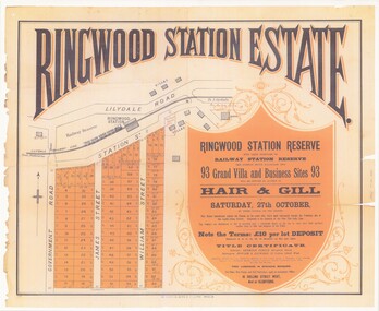 Ringwood and District Historical Society
Poster - Auction, Ringwood Station Estate, Ringwood, Victoria - circa 1925
... & Gill, 16 Collins Street West and Glenferrie. Solicitor... and Glenferrie. Solicitor - Seymour Fergie, Elizabeth Street. Surveyors ...Colour photocopy of poster sub-titled Ringwood Station Reserve & Railway Station Reserve. Auction of 93 sites on Saturday 27th October (no year, likely 1925). Subdivision includes Station Street, Government Road (Wantirna Road), James Street, William Street. Auctioneers - Hair & Gill, 16 Collins Street West and Glenferrie. Solicitor - Seymour Fergie, Elizabeth Street. Surveyors - Fowler & Gatward, 12 Collins Street West. -
 Glen Eira Historical Society
Plan - Yeshivah & Beth Rivkah College
This file contains a set (incomplete) of 7 architectural drawings prepared by architects Synman Justin Balek and Best Overend and Partners - Existing site and Master Plan o - Primary School Administration and Community Facility - Synagogue Refurbishment 2 - Multipurpose Hall 3 - Glenferrie Property – Refurbishment of Residence 5 – Glenferrie Property - New Kindergarten 6 - Another Property Refurbishment of Residence 7school, plans, saint kilda east, independent school, architects, hotham street, yeshivah and beth rivkah college, synman justin balek, balaclava road, best overend & partners -
 Eltham District Historical Society Inc
Scrapbook Page, Scrapbook page of photos, Eltham, 1920s to 1940s
Pages from a scrapbook belonging to Heather Jenkins (nee Cone) who lived as a child in the Police Residence at 728 Main Road, Eltham from 1911 till the early 1920s.Heather McKnight Jenkins (nee Cone) was born 1911, possibly at the Eltham Police Residence and spent her childhood growing up in the Police Residence. Heather was the daughter of John Thomas Cone, Police Constable, and Charlotte Helena Cone (nee Black) who had married in 1906. Constable Cone was transferred to Eltham Police Station from Lauriston (near Kyneton) in May 1911. He retired from the force around September 1922 most likely as a result of significant health concerns experienced earlier that year from 22 April when he was hospitalised. He died 5 October 1922 at Maria Street at age 60 leaving behind a widow and two daughters; his son having pre-deceased him as a result of effects of the war. He is buried in Melbourne General Cemetery . In his probate it states that he owned a piece of land 200 links frontage to Maria Street and a depth of 241 links. It is believed that this is the land opposite the Police Station which Heather Jenkins referred to as being owned by her father and where he agisted the Police horses. Heather, her sister and mother Charlotte remained in Eltham until at least the 1924 Electoral Roll where Charlotte was listed as Home Duties however by 1925 she was listed at 229 Glenferrie Road, Malvern, occupation, Registrar of Births. In the 1934 (and 1936) Electoral Roll, Heather was a Clerk and her mother Charlotte was the Registrar of Births. in 1952 following her mother’s death she made application for Grant of Probate. Heather remains listed in the 1954 Electoral Roll at 13 Ashburton Road under her maiden name Cone however by the 1963 Electoral Roll she is listed at the same address as Heather McKnight Jenkins long with James Gardiner Jenkins. Neither appear listed in the 1958 Electoral Roll. James Gardiner Jenkins (1892-1975) first wife was Fanny Davison Carrucan (1899-1929), daughter of Denis Carrucan and Jane (nee McAleese). They married in 1925. Fanny died 11 November 1929. In the 1934 Electoral Roll he remained listed at John Street, Eltham, Railway Employee however by 1935 Electoral Roll, James Gardiner Jenkins, Railway Employee, was listed at 229 Glenferrie Road, Malvern and he remained living with Charlotte and Heather Cone when they moved to 13 Ashburton Road, Glen Iris. One of Constable Cone’s first investigations upon arriving in Eltham was the accidental fatal shooting in the head with a pea rifle by young Francis August Capewell, aged 11, of John Sutcliffe Deegan, 14, in Maria Street near the Railway. Constable Cone’s replacement was Constable William Charles Sargeant who commenced in charge of the Eltham Police Station from Thursday, 10 August 1922. Constable William Charles Sargeant, and his wife Elizabeth Agnes Sargeant were based at the Eltham Police Station until his transfer to the Police Station in Burwood Road, Hawthorn. He retired at Hawthorn Police Station in 1931, described by Hawthorn Council in 1927 as in a disgraceful condition and unfit for human habitation (Kathryn Griffin family tree – Ancestry) whereupon they moved to 28 Saunders Street, Coburg. Elizabeth died 16 July 1936 in Fitzroy. William then moved to 6 Queen Street Coburg in 1936 and then 1 Queen Street in 1942 where he died 7 August 1944. He is buried at Fawkner Cemetery. Brown paper scrapbook page (torn from scrapbook) with 8 black and white/sepia photos of varying sizes, 1 newspaper clipping and one greeting card with printed sketch and handwritten captions in ink. On back of page is 1 black and white photo and a large newspaper clipping.eltham, police residence, walter withers, heather mcknight jenkins (nee cone), constable john thomas cone, charlotte helena cone (nee black) -
 Eltham District Historical Society Inc
Memorabilia - Scrapbook Page, Scrapbook page of photos, Eltham, 1920s to 1940s
Pages from a scrapbook belonging to Heather Jenkins (nee Cone) who lived as a child in the Police Residence at 728 Main Road, Eltham from 1911 to the early 1920s.Heather McKnight Jenkins (nee Cone) was born 1911, possibly at the Eltham Police Residence and spent her childhood growing up in the Police Residence. Heather was the daughter of John Thomas Cone, Police Constable, and Charlotte Helena Cone (nee Black) who had married in 1906. Constable Cone was transferred to Eltham Police Station from Lauriston (near Kyneton) in May 1911. He retired from the force around September 1922 most likely as a result of significant health concerns experienced earlier that year from 22 April when he was hospitalised. He died 5 October 1922 at Maria Street at age 60 leaving behind a widow and two daughters; his son having pre-deceased him as a result of effects of the war. He is buried in Melbourne General Cemetery . In his probate it states that he owned a piece of land 200 links frontage to Maria Street and a depth of 241 links. It is believed that this is the land opposite the Police Station which Heather Jenkins referred to as being owned by her father and where he agisted the Police horses. Heather, her sister and mother Charlotte remained in Eltham until at least the 1924 Electoral Roll where Charlotte was listed as Home Duties however by 1925 she was listed at 229 Glenferrie Road, Malvern, occupation, Registrar of Births. In the 1934 (and 1936) Electoral Roll, Heather was a Clerk and her mother Charlotte was the Registrar of Births. in 1952 following her mother’s death she made application for Grant of Probate. Heather remains listed in the 1954 Electoral Roll at 13 Ashburton Road under her maiden name Cone however by the 1963 Electoral Roll she is listed at the same address as Heather McKnight Jenkins long with James Gardiner Jenkins. Neither appear listed in the 1958 Electoral Roll. James Gardiner Jenkins (1892-1975) first wife was Fanny Davison Carrucan (1899-1929), daughter of Denis Carrucan and Jane (nee McAleese). They married in 1925. Fanny died 11 November 1929. In the 1934 Electoral Roll he remained listed at John Street, Eltham, Railway Employee however by 1935 Electoral Roll, James Gardiner Jenkins, Railway Employee, was listed at 229 Glenferrie Road, Malvern and he remained living with Charlotte and Heather Cone when they moved to 13 Ashburton Road, Glen Iris. One of Constable Cone’s first investigations upon arriving in Eltham was the accidental fatal shooting in the head with a pea rifle by young Francis August Capewell, aged 11, of John Sutcliffe Deegan, 14, in Maria Street near the Railway. Constable Cone’s replacement was Constable William Charles Sargeant who commenced in charge of the Eltham Police Station from Thursday, 10 August 1922. Constable William Charles Sargeant, and his wife Elizabeth Agnes Sargeant were based at the Eltham Police Station until his transfer to the Police Station in Burwood Road, Hawthorn. He retired at Hawthorn Police Station in 1931, described by Hawthorn Council in 1927 as in a disgraceful condition and unfit for human habitation (Kathryn Griffin family tree – Ancestry) whereupon they moved to 28 Saunders Street, Coburg. Elizabeth died 16 July 1936 in Fitzroy. William then moved to 6 Queen Street Coburg in 1936 and then 1 Queen Street in 1942 where he died 7 August 1944. He is buried at Fawkner Cemetery. Brown paper scrapbook page (torn from scrapbook) with 9 black and white/sepia photos of varying sizes, 1 newspaper clipping and handwritten captions in ink.On verso in pencil "Const. W.C. Sargeant 1922-1927 - see Police list"eltham, police residence, constable w.c. sargeant, heather mcknight jenkins (nee cone), constable john thomas cone, charlotte helena cone (nee black) -
 Eltham District Historical Society Inc
Scrapbook Page, New Railway Line: Eltham to Hurst's Bridge; The Weekly Times, 24 Feb 1912, p27, 1912
Pages from a scrapbook belonging to Heather Jenkins (nee Cone) who lived as a child in the Police Residence at 728 Main Road, Eltham from 1911 to the early 1920s. Images featured are 1. A peep on the road, nearing Research. 2. The Main Road at Eltham (opposite Railway Station). 3. A part of the new railway line. 4. The mail coach leaving for Kangaroo Ground.Heather McKnight Jenkins (nee Cone) was born 1911, possibly at the Eltham Police Residence and spent her childhood growing up in the Police Residence. Heather was the daughter of John Thomas Cone, Police Constable, and Charlotte Helena Cone (nee Black) who had married in 1906. Constable Cone was transferred to Eltham Police Station from Lauriston (near Kyneton) in May 1911. He retired from the force around September 1922 most likely as a result of significant health concerns experienced earlier that year from 22 April when he was hospitalised. He died 5 October 1922 at Maria Street at age 60 leaving behind a widow and two daughters; his son having pre-deceased him as a result of effects of the war. He is buried in Melbourne General Cemetery . In his probate it states that he owned a piece of land 200 links frontage to Maria Street and a depth of 241 links. It is believed that this is the land opposite the Police Station which Heather Jenkins referred to as being owned by her father and where he agisted the Police horses. Heather, her sister and mother Charlotte remained in Eltham until at least the 1924 Electoral Roll where Charlotte was listed as Home Duties however by 1925 she was listed at 229 Glenferrie Road, Malvern, occupation, Registrar of Births. In the 1934 (and 1936) Electoral Roll, Heather was a Clerk and her mother Charlotte was the Registrar of Births. in 1952 following her mother’s death she made application for Grant of Probate. Heather remains listed in the 1954 Electoral Roll at 13 Ashburton Road under her maiden name Cone however by the 1963 Electoral Roll she is listed at the same address as Heather McKnight Jenkins long with James Gardiner Jenkins. Neither appear listed in the 1958 Electoral Roll. James Gardiner Jenkins (1892-1975) first wife was Fanny Davison Carrucan (1899-1929), daughter of Denis Carrucan and Jane (nee McAleese). They married in 1925. Fanny died 11 November 1929. In the 1934 Electoral Roll he remained listed at John Street, Eltham, Railway Employee however by 1935 Electoral Roll, James Gardiner Jenkins, Railway Employee, was listed at 229 Glenferrie Road, Malvern and he remained living with Charlotte and Heather Cone when they moved to 13 Ashburton Road, Glen Iris. One of Constable Cone’s first investigations upon arriving in Eltham was the accidental fatal shooting in the head with a pea rifle by young Francis August Capewell, aged 11, of John Sutcliffe Deegan, 14, in Maria Street near the Railway. Constable Cone’s replacement was Constable William Charles Sargeant who commenced in charge of the Eltham Police Station from Thursday, 10 August 1922. Constable William Charles Sargeant, and his wife Elizabeth Agnes Sargeant were based at the Eltham Police Station until his transfer to the Police Station in Burwood Road, Hawthorn. He retired at Hawthorn Police Station in 1931, described by Hawthorn Council in 1927 as in a disgraceful condition and unfit for human habitation (Kathryn Griffin family tree – Ancestry) whereupon they moved to 28 Saunders Street, Coburg. Elizabeth died 16 July 1936 in Fitzroy. William then moved to 6 Queen Street Coburg in 1936 and then 1 Queen Street in 1942 where he died 7 August 1944. He is buried at Fawkner Cemetery. Large newspaper clipping (half page), very aged and fragile with sticky tape holding it together with 4 images of early Elthameltham, police residence, heather mcknight jenkins (nee cone), constable john thomas cone, charlotte helena cone (nee black) -
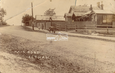 Eltham District Historical Society Inc
Photograph, J.H. Clark (poss), Main Road, Eltham, c.1910
Original photo from a scrapbook belonging to Heather Jenkins (nee Cone) who lived as a child in the Police Residence at 728 Main Road, Eltham from 1911 to the early 1920s. (Reported in Newsletter No. 98, Sept., 1994). View looking north up Policeman’s Hill across Main Road towards the Police Station, Police Residence and Courthouse, c.1910 prior to Brougham Street being made. The two rails / gap in the fence would be where Brougham Street now enters Main Road. Also visible are Knapman's Forge adjacent to Courthouse and E.J. Andrew's Store on top of the hill At the upper left can be seen the front of the Evelyn Hotel. On the opposite corner was Watsons Hotel. E.J. Andrew's store with its verandah was on the corner of Franklin Street. Behind the picket fence stands the 1860 Court House and Police residence with the weatherboard clad Police office. The enclosed fence is now the end of Brougham Street, opened to Bible Street in 1926. The Evelyn Hotel (formerly Fountain of Friendship) burnt down in the 1930s when it was being used as a boarding house since 1919. A cow is feeding on the grass verge in street. The photo is identified in white lettering typical of the style of Clark Bros., photographers of Windsor, Melbourne (1894-1914). One of the brothers, John Henry Clark, took many early photos around Little Eltham and moved to Eltham in 1916 where he lived at the bottom of the hill. Typically, he would add “J.H. Clark Photo” to his personal work, but this is not evident. There is however some ghost writing, a cheeky inscription in small white lettering in the grass verge in front of where Brougham Street is, which appears to state: “Heather or Hannah was here”. Perhaps J.H. Clark took the photo during a trip to Eltham and gifted it some years later after moving there as a gift to a young Heather Cone. The Police Station sign: E vii R ELTHAM POLICE STATION HEIDELBERG DISTRICT Edward VII ascended the throne in 1901 and died 6 May 1910. He was succeeded by George V.Heather Cone was the daughter of Constable John Thomas Cone (Badge 3935) the local police officer in residence at Eltham, 1 May 1911 to 9 July 1922. Heather McKnight Jenkins (nee Cone) was born 1911, possibly at the Eltham Police Residence and spent her childhood growing up in the Police Residence. Heather was the daughter of John Thomas Cone, Police Constable, and Charlotte Helena Cone (nee Black) who had married in 1906. Constable Cone was transferred to Eltham Police Station from Lauriston (near Kyneton) in May 1911. He retired from the force around September 1922 most likely as a result of significant health concerns experienced earlier that year from 22 April when he was hospitalised. He died 5 October 1922 at Maria Street at age 60 leaving behind a widow and two daughters; his son having pre-deceased him as a result of effects of the war. He is buried in Melbourne General Cemetery . In his probate it states that he owned a piece of land 200 links frontage to Maria Street and a depth of 241 links. It is believed that this is the land opposite the Police Station which Heather Jenkins referred to as being owned by her father and where he agisted the Police horses. Heather, her sister and mother Charlotte remained in Eltham until at least the 1924 Electoral Roll where Charlotte was listed as Home Duties however by 1925 she was listed at 229 Glenferrie Road, Malvern, occupation, Registrar of Births. In the 1934 (and 1936) Electoral Roll, Heather was a Clerk and her mother Charlotte was the Registrar of Births. in 1952 following her mother’s death she made application for Grant of Probate. Heather remains listed in the 1954 Electoral Roll at 13 Ashburton Road under her maiden name Cone however by the 1963 Electoral Roll she is listed at the same address as Heather McKnight Jenkins long with James Gardiner Jenkins. Neither appear listed in the 1958 Electoral Roll. James Gardiner Jenkins (1892-1975) first wife was Fanny Davison Carrucan (1899-1929), daughter of Denis Carrucan and Jane (nee McAleese). They married in 1925. Fanny died 11 November 1929. In the 1934 Electoral Roll he remained listed at John Street, Eltham, Railway Employee however by 1935 Electoral Roll, James Gardiner Jenkins, Railway Employee, was listed at 229 Glenferrie Road, Malvern and he remained living with Charlotte and Heather Cone when they moved to 13 Ashburton Road, Glen Iris. One of Constable Cone’s first investigations upon arriving in Eltham was the accidental fatal shooting in the head with a pea rifle by young Francis August Capewell, aged 11, of John Sutcliffe Deegan, 14, in Maria Street near the Railway. Constable Cone’s replacement was Constable William Charles Sargeant who commenced in charge of the Eltham Police Station from Thursday, 10 August 1922. Constable William Charles Sargeant, and his wife Elizabeth Agnes Sargeant were based at the Eltham Police Station until his transfer to the Police Station in Burwood Road, Hawthorn. He retired at Hawthorn Police Station in 1931, described by Hawthorn Council in 1927 as in a disgraceful condition and unfit for human habitation (Kathryn Griffin family tree – Ancestry) whereupon they moved to 28 Saunders Street, Coburg. Elizabeth died 16 July 1936 in Fitzroy. William then moved to 6 Queen Street Coburg in 1936 and then 1 Queen Street in 1942 where he died 7 August 1944. He is buried at Fawkner Cemetery.Sepia postcard photo glued on a brown paper scrapbook page (torn from scrapbook) along with 8 other black and white/sepia photos of varying sizes, 1 newspaper clipping and handwritten captions in ink.brougham street, constable w.c. sargeant, courthouse, cow, eltham, knapmans forge, little eltham, local history centre, main road, maria street, police residence, police station, policeman's hill, scrapbook, w.b. andrew corn store, j.h. clark photo, andrews store, heather jenkins (nee cone), clark bros. photo -
Glen Eira Historical Society
Book - CAULFIELD CENTENARY 1957
This file contains four items 1/Two copies of a twenty-four page booklet titled CITY OF CAULFIELD CENTENARY 1857-1957, created by the Caulfield City Council and printed by Peter Isaacson Pty Limited, Melbourne. The booklet details important aspects of Caulfield’s history including council procedures, the Caulfield Road District Proclamation, the first election and a summary of 100 years of local government with a description of the present Caulfield in 1957. The booklet also includes several pictures of various Caulfield landmarks and people including one of Caulfield City Councillors (11 men and 1 woman). Also one photocopied version of this booklet. 2/Eleven pages of typed notes for the City of Caulfield Centenary booklet. All notes are undated and incomplete. Two pages titled NOTES on THE HISTORY and PROGRESS OF THE CITY OF CAULFIELD, author unknown. Three and a half pages titled THE STRUCTURE OF LOCAL GOVERNMENT IN VICTORIA, author unknown. Five pages titled 100 YEARS OF LOCAL GOVERNMENT – EARLY CAULFIELD, by Mrs A. P. Bell. 3/A typed letter to Miss V. Webb-Langdon from the Town Clerk H.G. Nelson, acknowledging her contribution to historical details for the Caulfield Council’s Centenary booklet, dated 24/12/1957. 4/A handwritten letter and a handwritten note regarding the acquisition of notes for the Caulfield Centenary booklet. The letter is dated 03/08/2006 and the note is dated 09/02/2007.city of caulfield centenary, caulfield road district, sinclair a.j.g., city hall, war memorials, gamble h.a., machin l.r., bunny f.c.d., caulfield park, koornang reserve, parton e.m., sims h.e., thomson w.r., gunn e.e., yorston j.s., wallace g.e. mrs, green w.c., jenner e.r., ward boundaries, dandenong road, queens avenue, normanby road, station street, bond street, glen eira road, orrong road, poath road, north road, booran road, nepean highway, glen huntly road, glenhuntly road, inkerman road, hotham street, nelson h.g., fullard w.r., mackley g.j., ellis k.i, crosbie m.r., nutting b.i., body j.h., pritchard r.j., guildford l.t.g., lund l.m., street h.c., reynolds a.w., elections , political processes, local government, springthorpe reserve, greenmeadows gardens, business and finance, roads and streets, caulfield racecourse, east caulfield reserve, mackinnon reserve, hawthorn road, balaclava road, murrumbeena road, lempriere avenue, victoria street, koornang road, lord reserve, lyons street, murrumbeena reserve, kangaroo road, ormond park, beatty crescent, foch street, packer reserve, oakleigh road, leila road, prices park, bambra road, riley reserve, playgrounds, town hall, maternal and child health centres, truganini road, grange road, senior citizens centre, barkley sir henry, moore david, handasyde gilbert, caulfield school room, harris g.w., semple john, dempsey william, brooks w.a., wilson thomas, lyall william, murrum murrumbeen lifestyle, ‘greenmeadows’ house, lempriere family, aboriginal culture, ‘rippon lea’ house, caulfield john, ‘slaney’s’ home, alma road, paddy’s swamp, racecourse hotel, caulfield technical college, bevan mr., ‘grosmont’, hart john, railways, mansions, ‘rosecraddock’, langdon h. j., caulfield cup, ‘crotonhurst’, webb judge, ‘kilwinning’, service james, ricketson henry, ‘glen eira’, house names, garden vale, ross william murray, ‘ross’s folly’, outer circle railway, caulfield grammar school, davies j. henry, lagdon william, grimwade f.s., loyd charles du plan, hope george, ‘airdrie’, kooyong hill, market gardens, dairies, lady talbot milk supply, jenner family, o’niell college, presentation sisters, glenferrie road, grimwade frederick sheppard, grimwade alice, ‘harlston’, grimwade house, ‘saint aubin’s’, ‘st. aubin’s’, ‘caulfield hall’, caulfield john p.t., st georges road, caulfield military hospital, nursing homes, health establishments, dover street, sports and recreations, rosanna street, ‘cantala’, health services, parks and reserves, community services, town planning, local government finance, local officials and employees -
Port Melbourne Historical & Preservation Society
Book, Terry Keenan, "Once were Champions", 2017
"Once were Champions" Book written by Terry Keenan on the first 50 years of the Port Melbourne Cricket Club. Blue and white cover and picture of cricket match at Glenferrie Oval. Logo of Port Melbourne Cricket Club at top with church buildings in background.The first fifty years of the Port Melbourne Cricket Club.sport - cricket, port melbourne cricket club, terry keenan -
Port Melbourne Historical & Preservation Society
Document - Victorian Railway tickets, c. 1960' & 70's
From the collection of Warren DOUBLEDAY. Tickets were given to donor by retired railway officials who were given access to them for their collections following the tickets withdrawal from use. Fifteen are for journeys to and from the Port Melbourne station and include Single, Weekly and 'Extended Periodical' tickets.Those from Graham Street Station include three singles & one 'Periodical Pass'. As well as the singles & weekly tickets, the 24 to & from North Port Station also include a 'Periodical Pass' and one for a 'Collapsible Pram'. . From Montague Station single and weekly journeys make up the eight tickets. The weekly tickets show how far people would travel to work in Port Melbourne. From Ascot Vale, Broadmeadows, Carrum, Coburg, Gowrie, Malvern, Mont Albert, Reservoir, St Albans, Thorrnbury, Williamstown, Yarramam. Single tickets are for travel to or from Auburn, Clayton, Collingwood, Glenferrie, Hawthorn, Kensington, Melbourne, Mont Albert, Moonee Ponds, Richmond, West Footscray, A collection of 51 undated railway tickets.transport - railways, north port station, graham station, montague station, port melbourne station -
 Uniting Church Archives - Synod of Victoria
Photograph, undated c.1912 - 1920
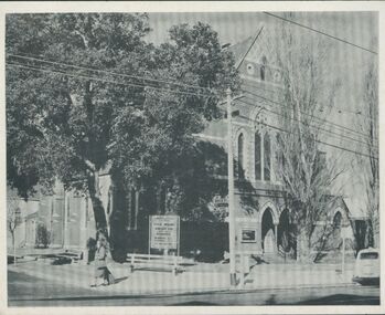
The Malvern Congregational Church was built in 1886, replacing the original church built in 1873. The 1886 church was demolished in 1996. A Coles Supermarket was built on the site.B & W photograph of the Malvern Rd. Congregational Church located at the corner of Winter St. and Glenferrie Rd. malvern congregational church, sunday school, picnic -
 Uniting Church Archives - Synod of Victoria
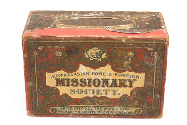
Giving Box, Australasian Home & Foreign Missionary Society giving box, ? Late 19th Century
Wooden giving box with paper labelsTop: "freely Ye Have Received! xxx [illegible] Give". Front: "Australasian Home & Foreign Missionary Society : Go ye into all the world and preach the Gospel to every creature". Side 1: "He shall speak peace unto the Heathen". Side 2: "The Idols he shall utterly Abolish". Back: " This Box should be opened and the Money sent to Rev. B. Danks, Glenferrie Road, Kew, not later than the end of January in each year B.D."australasian home & foreign missionary -
 Kew Historical Society Inc
Plan, Borough of Kew Detail Plan No.1577, 1904
The Melbourne and Metropolitan Board of Works (MMBW) plans were produced from the 1890s to the 1950s. They were crucial to the design and development of Melbourne's sewerage and drainage system. The plans, at a scale of 40 feet to 1 inch (1:480), provide a detailed historical record of Melbourne streetscapes and environmental features. Each plan covers one or two street blocks (roughly six streets), showing details of buildings, including garden layouts and ownership boundaries, and features such as laneways, drains, bridges, parks, municipal boundaries and other prominent landmarks as they existed at the time each plan was produced. (Source: State Library of Victoria)This plan forms part of a large group of MMBW plans and maps that was donated to the Society by the Mr Poulter, City Engineer of the City of Kew in 1989. Within this collection, thirty-five hand-coloured plans, backed with linen, are of statewide significance as they include annotations that provide details of construction materials used in buildings in the first decade of the 20th century as well as additional information about land ownership and usage. The copies in the Public Record Office Victoria and the State Library of Victoria are monochrome versions which do not denote building materials so that the maps in this collection are invaluable and unique tools for researchers and heritage consultants. A number of the plans are not held in the collection of the State Library of Victoria so they have the additional attribute of rarity.Original survey plan, issued by the MMBW to a contractor with responsibility for constructing sewers in the area identified on the plan within the Borough of Kew. The plan was at some stage hand-coloured, possibly by the contractor, but more likely by officers working in the Engineering Department of the Borough and later Town, then City of Kew. The hand-coloured sections of buildings on the plan were used to denote masonry or brick constructions (pink), weatherboard constructions (yellow), and public buildings (grey). MMBW Plan No.1577 includes some of the most significant houses in Kew: Herbert Henty’s ‘Roxeth’ (now part of Trinity Grammar), ‘Butleigh Wooton’, ‘Bokara’ and ‘Harrow’. It also includes the streets that have since changed their names. That part of College Parade linked to Glenferrie Road is now named College Place, College Parade now extends further north, and Charles Street did not yet reach Barkers Road. Roxeth is one of a number of Henty houses in Kew. Herbert Henty made his home here and was elected a member of Kew Municipal Council in 1864 and mayor in 1868-69. Walter Henry Serle, of Harrow served in the First World War. He was awarded the Military Medal ‘’For conspicuous bravery and devotion to duty. On 29th September near BELLICOURT he showed the greatest bravery and determination when his platoon was attacked by enemy bombing parties. It was due largely to his personal efforts that all the attacks were repulsed. Until wounded, his utter disregard of personal safety and boldness in dealing with the attacks were the means of saving the situation and were an inspiring example to his men.’melbourne and metropolitan board of works, detail plans, maps - borough of kew, mmbw 1577, cartography -
 Kew Historical Society Inc
Photograph - Victorian Villa, High Street, c.1922
Subdivision plans are historically important documents used as evidence of the growth of suburbs in Australia. They frequently provide information about when the land was sold on which a built structure was subsequently constructed as well as evidence relating to surveyors and real estate and financial agents. The numerous subdivision plans in the Kew Historical Society's collection represent working documents, ranging from the initial sketches made in planning a subdivision to printed plans on which auctioneers or agents listed the prices for which individual lots were sold. In a number of cases, the reverse of a subdivision plan in the collection includes a photograph of a house that was also for sale by the agent. These photographs provide significant heritage information relating house design and decoration, fencing and household gardens.An old inscription on this photograph identifies it as ‘an elegant timber villa in High Street. It occupied part of Lot 91, bought by Edward Glyn in the land sale of 16th October 1851, and run as a flower farm’. The subdivision called the ‘Flower Farm Estate’ in East Kew occurred in 1922. [The subdivision plan is on the reverse of this photo.] The Estate included 61 lots on either side of Boorool Road between High Street and Harp Road. In the MMBW Detail Plan 2017 of 1926, a number of these new villas had already been built. Matching houses with MMBW maps can always be a challenge, however if this house was near the corner of Boorool Road and High Street, it seems to fit the profile of a house called ‘Maxton’ (demolished).Photographer's name on photograph, lower right, and stamp on mount lower right: "A. Aberline, Glenferrie".houses - maxton - high street - kew (vic.), violet farm estate, subdivisions - kew (vic.) -
 Kew Historical Society Inc
Plan - Subdivision : Cotham and Glenferrie Roads, J R Mathers & McMillan
The Kew Historical Society's map collection includes a substantial number of real estate subdivision plans, mainly of Kew but also of surrounding suburbs in Melbourne. Most of the subdivision plans date from the 1920s and 1930s when the districts old homes and local farmland were being split up to accommodate residential growth in the postwar period. These early plans were assembled by a local firm, Jas R Mather & McMillan, which had an office in Cotham Road. Many of the plans, and sometimes photos, were annotated by the agents.Subdivision plans are historically important documents used as evidence for the growth of suburbs in Australia. They frequently provide information about when the land was sold as well as evidence relating to surveyors and real estate and financial agents. The numerous subdivision plans in the Kew Historical Society's collection represent working documents, ranging from the initial sketches made in planning a subdivision to printed plans on which auctioneers or agents listed the prices for which individual lots were sold. In a number of cases, the reverse of a subdivision plan in the collection includes a photograph of a house that was also for sale by the agent. These photographs provide significant heritage information relating house design and decoration, fencing and household gardens.The photograph may also be aesthetically significant depending on the importance of the photographic atelier.An undated and untitled hand-drawn and coloured subdivision plan detailing the boundaries of a number of irregular allotments bordering Cotham Road, Glenferrie Road and Stirling Avenue (now Stirling Street). The plan predates the actual subdivision that led to the creation of the eight commercial properties occupying 118-132 Cotham Road. The plan may represent an old subdivision that was further subdivided at a later date, or it may be a subdivision that never eventuated. On MMBW Detail Plan 1575 (1903), the area represented by the proposed subdivision was residential rather than commercial. The irregularity of lots is also apparent in the MMBW Plan. The largest of the unnumbered blocks on the hand-drawn subdivision plan may relate to the boundaries of the nineteenth century mansion identified as ‘Kelso’ on the MMBW Plan.subdivision plans - kew, cotham road - kew,, glenferrie road - kew , stirling avenue street - kew -
 Kew Historical Society Inc
Document - Urban Planning Document, City of Kew, City of Kew : Minimum Size of Allotment Required, 1945-1955
A document outlining the relevant by-laws produced by the City Of Kew to regulate the minimum size of allotments in Barkers Road, Burke Road, Cotham Road, Glenferrie Road and Studley Park Road, as well as in other streets more generally. The by-laws specify the size of allotments in which single unit dwellings, attached houses and maisonettes, and flats could be built. In the ‘main streets’ a minimum land area for single unit dwellings was 8,100 square feet, with an average frontage of 60’ and a depth of 135’. In other streets this was reduced to an overall size of 6,250 square feet, with an average dimensions of 50’ x 125’. In specifying the land area required by flats, different sizes were regulated for the construction of between two and six flats. Six flats at the time when the regulations were passed must have been the upper limit permitted. Understanding the size of land listed in imperial measurements can be a challenge. Within Australia, the so-called quarter acre block was approximately 11,000 square feet. Those specified in the by-laws would appear to be smaller. The document was pasted on the reverse of a subdivision plan in the collection.This is a rare (undated) document produced by the City of Kew defining how subdivision within the municipality should occur. The document was created to constrain unbridled speculation in subdivisions in the various parts of Kew and East Kew.Undated typed document, issued by the City of Kew (1921-1994) indicating the minimum size of allotment required in Barkers Road, Burke Road, Cotham Road, Glenferrie Road and Studley Park Road. The document is mounted on board and waterstained. It was presumably used by a real estate agent. [Formerly catalogued as MAP.0066].city of kew - by-laws and regulations, subdivisions - kew - studley park -
 Kew Historical Society Inc
Legal record - The Indenture, Crown Portion 86, otherwise known as 'The Morgan Deed', 1852 (and later)
This indenture once formed part of the City of Kew's Municipal Collection. Cr. W.D. Vaughan in his history 'Kew's Civic Century' (1960) records on page 194 that: "The original deed of conveyance of the land being all of Crown Portion 86, Kew, purchased by John Quick, James Venn Morgan, Samuel Derrick and William Derrick was presented by the Historical Society of Victoria on behalf of Mrs Fryer, a daughter of the later J.V. Morgan, to the [Kew] Council on August 5, 1941. Crown Portion 86, comprised all the land between Cotham Road and High Street to an alignment opposite the east boundary of Glenferrie Road. On it the first residential house was built by Mr. J.V. Morgan in 1852." Following the donation, the Indenture was surrounded by other original related text and explanatory notes and framed. The resulting framed documents are the largest framed objects in the collection.The Indenture and the accompanying contextual documents are some of the most historically significant manuscripts to have survived since the settlement of Kew in the 1850s. They provide a link to Kew's most famous pioneering families.Framed 1952 Indenture recording the sale of land in Kew to pioneering Kew families.james venn morgan, john quick, william derrick, samuel derrick, kew (vic) - history, kew (vic) - pioneers, samuel watts, kew (vic.) — municipal collection -
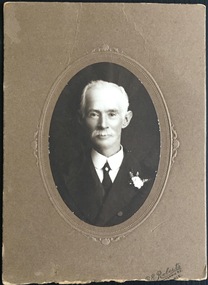 Kew Historical Society Inc
Photograph, Godfrey E Roberts, Mr Whitman, c.1914
The Padbury family were early pioneers of Kew, running for over a century a funeral parlour in Cotham Road. The photograph of Mr Whitman can be reliably dated to 1914 or later due to an article on the establishment of Godfrey Roberts' atelier at the rear of Mr Chenoweth's in Glenferrie Road (Source: 'Godfrey E Roberts Photographic Studio', Hawthorn Kew Camberwell Citizen, 5 June 1914, p. 2)This, and other photographs of members of the Whitman-Padbury families was donated by Mrs Clarrie Thomson, a descendant of the families, and a member of the Society. Mrs Thompson lived at 58 Charles Street, Kew. The donation was made in 1982.Cabinet card, produced by Godfrey E Roberts of Glenferrie Road (Glenferrie), of Mr Whitman, a relative by marriage of the Padbury family. "Whitman" "G E Roberts / Glenferrie Rd / Glenferrie" (photographer)whitman - padbury, pioneer families -- kew -
 Kew Historical Society Inc
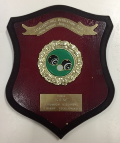
Award, Glenferrie Hill Recreation Club, John Dobbie Jubilee Shield, 1984
Sports Clubs in Kew in the final decades of the 19th century and in the early 20th century were often umbrella organisations with facilities for a number of sports. Typically in Kew, this included teams in lawn bowls, tennis and croquet. The Kew Bowling Club was formed in 1880 while the privately owned Auburn Heights Recreation Club was opened in 1904. By 1998, the two Clubs decided to amalgamate at the Auburn Heights site in Barkers Road, forming the Kew Heights Sports Club. The combined club was itself taken over by the Melbourne Cricket Club in 2012 becoming MCC Kew Sports Club. In 2017 MCC Kew closed and its landholding was subsequently sold to Carey Baptist Grammar School. Both the Kew and Auburn Heights Clubs assembled important collections. These historically significant and large collections were donated to the Society in 2020. The collections include manuscripts, pictures, trophies, plans, honour boards etc. References Barnard FGA 1910, 'Sports and Pastimes' in Jubilee History of Kew Victoria: Its origin & progress 1803-1910. Nixon NV 1980, The History of the Kew Bowling Club 1880-1980. Reeve S 2012, City of Boroondara: Thematic Environmental History, p.216.The combined collections of the four sporting clubs making up the collection number hundreds of items that are historically significant locally. They are also significant to the sporting history of the greater Melbourne area and to the sports of lawn bowls and tennis in Australia in the 19th and 20th centuries. The collection illuminates two of the Victorian historic themes - 'Building community life' through forming community organisations and 'Shaping cultural and creative life' by participating in sport and recreation.John Dobbie Jubilee Shield, Glenferrie Hill Recreation Club won by Kew Bowling Club, 1984.GLENFERRIE HILL RECREATION CLUB / JOHN DOBBIE JUBILEE SHIELD / 1984 KEW / A THOMPSON, N BUSHBY, R HARRIS, F O'CALLAGHAN (C)kew bowling club - wellington street - kew (vic), clubs - lawn bowls - kew (vic), kew bowling club - trophies -
![Uniform - School Uniform, Woodbury Ladies’ College [Kew] Badge, circa 1918, c.1918](/media/collectors/550653872162f11fb04854aa/items/5e89f58a21ea671a7c03d0c9/item-media/5e89f65821ea671a7c0508fc/item-fit-380x285.jpg) Kew Historical Society Inc
Kew Historical Society IncUniform - School Uniform, Woodbury Ladies’ College [Kew] Badge, circa 1918, c.1918
Woodbury College was an indirect predecessor of Preshil School in Kew. Woodbury College was founded in Glenferrie Road by a Miss Harcourt, former principal of Sydenham College, Moonee Ponds. Miss Harcourt maintained the school until the goodwill was purchased in 1908 by Miss LJ Macey, who had previously operated Lillsden Ladies' College in Edgevale Road, between c.1891 and c.1903. The first school was in a rented building on the south side of Cotham Road between Atkins and Davis Streets. In 1910, a new school building was built on the corner of Uvadale Grove and Cotham Road [the building is still extant as of 2020]. Woodbury College was operated by Miss LJ and Miss HJ Macey until 1920. In 1921, the school amalgamated with the newly formed St Andrew's College, Mont Victor Road, Kew (Vic) under the leadership of Rev JT Lawton [who had previously been principal of St Andrew's School of the 'Pathfinder' in South Yarra]. Miss Macey was for a period the Headmistress of the amalgamated school. Another teacher at the school was Miss Margaret JR Lyttle, who in 1931, left St Andrew's to form the Preshil School.Rare ephemera relating to an early private school in Kew (Vic). The badge was donated by Helen Lade.Brass school badge which includes the initials WL within a large C, surrounded with the school crest - VERITAS VINCIT [Truth Prevails] of Woodbury Ladies College (1903-1920). woodbury college, schools - cotham road - kew - vic, private schools - kew (vic) -
Kew Historical Society Inc
Archive (series) - Subject File, Kew Historical Society, Woodbury Ladies' College, 1986
Various partiesReference, Research, InformationSecondary Values (KHS Imposed Order)Subject file containing information about Woodbury College, Cotham Road, Kew (Vic). The file includes historically significant primary sources relating to the former Woodbury College [c.1898-1920] and Lillsden Ladies' College, Edgevale Road, Kew (Vic) [c.1891-1903]. In addition to manuscripts, the file also includes photographs and ephemera such as a metal school badge, a hatband and printed programs and school magazines. The file [as of 2020] includes materials donated between 1986 and 2005 by descendants of the second principal (Miss Macey), and by former students and or their descendants. The contents of the reference file include: 1. School origins : undated handwritten manuscript [2pp]; 2. Annual Reports : Handwritten manuscripts for the years 1908, 1909, 1910, 1912, 1913, 1914, 1916, 1917, 1919, 1920 by Miss LJ Macey; 3. Prize List : undated manuscript [3pp]; 4. School Magazine ; undated handwritten manuscripts about the origin of the school's magazine; 5. Woodbury Chat [school magazine] : printed booklets from the years 1918, 1919, 1920 x 2; 6. Correspondence [sundry] : handwritten letters from a parent [1916] and a former pupil (sic) [1938] to Miss Macey; 7. Exercise Books : one containing a handwritten history of the school(s) and the names and addresses of former students and teachers; and the other containing information relating to the National Home Reading Union, Kew Circle [1912-c.1916]. 8. Metal school badge and photographic negative of students. The names of various donors are listed in the file: they include Ann Ransom, Muriel Coghlan, Helen Lade, and Lilian McRae (nee Houston).woodbury college, misses macey, schools - kew (vic), schools - cotham road - kew - vic, private schools - kew (vic), rev jt lawton, cotham road - kew (vic.)woodbury college, misses macey, schools - kew (vic), schools - cotham road - kew - vic, private schools - kew (vic), rev jt lawton, cotham road - kew (vic.) -
![Uniform - School Uniform, Hatband of Woodbury Ladies’ College [Kew], circa 1918, c.1918](/media/collectors/550653872162f11fb04854aa/items/5e254add21ea671e18757914/item-media/5e254b2121ea671e1875b9aa/item-fit-380x285.jpg) Kew Historical Society Inc
Kew Historical Society IncUniform - School Uniform, Hatband of Woodbury Ladies’ College [Kew], circa 1918, c.1918
Woodbury College was an indirect predecessor of Preshil School in Kew. Woodbury College was founded in Glenferrie Road by a Miss Harcourt, former principal of Sydenham College, Moonee Ponds. Miss Harcourt maintained the school until the goodwill was purchased in 1908 by Miss LJ Macey, who had previously operated Lillsden Ladies' College in Edgevale Road, between c.1891 and c.1903. The first school was in a rented building on the south side of Cotham Road between Atkins and Davis Streets. In 1910, a new school building was built on the corner of Uvadale Grove and Cotham Road [the building is still extant as of 2020]. Woodbury College was operated by Miss LJ and Miss HJ Macey until 1920. In 1921, the school amalgamated with the newly formed St Andrew's College, Mont Victor Road, Kew (Vic) under the leadership of Rev JT Lawton [who had previously been principal of St Andrew's School of the 'Pathfinder' in South Yarra]. Miss Macey was for a period the Headmistress of the amalgamated school. Another teacher at the school was Miss Margaret JR Lyttle, who in 1931, left St Andrew's to form the Preshil School.Rare ephemera relating to an early private school in Kew (Vic). The hatband was worn by Lilian McCrae in circa 1918 and donated by her sister Heather Houston. The badge was donated by Helen Lade.Navy blue hatband with narrow white and yellow stripes of Woodbury Ladies College (1903-1920). woodbury college, schools - cotham road - kew - vic, private schools - kew (vic)