Showing 144 items
matching greensborough street names
-
 Greensborough Historical Society
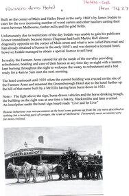
Article, Farmers Arms Hotel, 2012
The Farmers Arms Hotel stood on the corner of Main Street and Hailes Street Greensborough from the early 1860s until 1925 when the current building on this site was erected and named the Greensborough Hotel after the establishment of that name, further up the hill, was burnt down in 1923. 1 page, text and black and white imagefarmers arms hotel, greensborough hotel, main street greensborough -
 Greensborough Historical Society
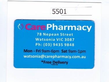
Refrigerator magnet, Care Pharmacy, 2000c
Name changed to Watsonia Compounding Pharmacy, 9/78 Nepean Street Watsonia 3087 (Diamond Village Shopping Centre)Refrigerator magnet, red, white and black print on blue"Care Pharmacy", address, phone number, opening hours and emailpharmacies -
 Greensborough Historical Society
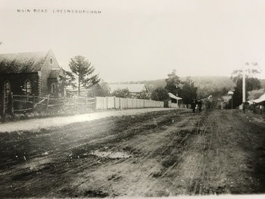
Photograph, Main Road Greensborough c1900, 1900c
... Main Road (later re-named Main Street) Greensborough c1900... Street) Greensborough c1900. Note Methodist Church on left, site ...Main Road (later re-named Main Street) Greensborough c1900. Note Methodist Church on left, site of present entrance to the shopping complex. Also shows the Rechabite Hall further down on the left side. Tracks of buggy wheels on unsealed road.A collection of 5 enlargements of sites in Greensborough township in the early 1900s.Black and white enlargement of photographic imagemain street greensborough, methodist church greensborough, rechabite hall -
 Greensborough Historical Society
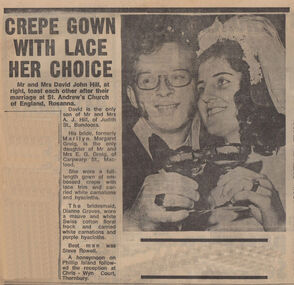
Newspaper Clipping - Digital Image, Crepe gown with lace her choice, 21/08/1973
A report on the marriage of Marilyn and John Hill. [1973] Marilyn's maiden name was Greig and she lived in Carwarp Street Macleod. Digital copy of newspaper article, black text and image.hill family -
 Greensborough Historical Society
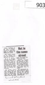
Newspaper Clipping, Diamond Valley News, Not in the same street, 24/10/1978
William Street Greensborough was split into 'north' and 'south' when the rail crossing was closed. In this article one resident suggests that the north area have a change of name. This section is now called Pinehills Drive,Photocopy of news article, black and white text.william street greensborough, wuchatsch, pinehills drive -
 Greensborough Historical Society
Painting - Digital image, Main Street Greensborough 1889 / by Arthur Elliott; with property names, 1889_
... Greensborough 1889, by Arthur Elliott, with names of properties ...Copy of painting of Main Street Greensborough 1889, by Arthur Elliott, with names of properties and owners.An early view of Greensborough that has property names and owners superimposed.Digital copy of painting.Names of properties and owners typed on copy.main street greensborough, arthur elliott -
 Greensborough Historical Society
Photograph - Digital image, Marble Hall, 1930-1940
Photograph of "Marble Hall", Greensborough. The Marble Hotel, Greensborough was located at the corner of Main Street and Para Road. The first licensed hotel in Greensborough and one of the earliest brick buildings was built by James Chapman in the early 1850s as a hotel and lodging house to cater for wood carters and those trying their luck at the gold fields but served many functions over the years including post office, general store, public hall, butchers, bakers, surgery, private dwelling and baby health care centre. It got its name due to its white washed exterior. This photo is from the Lorraine Coates Collection.Photograph of early Greensborough building, now demolished.Digital copy of black and white photograph.marble hotel greensborough, james chapman, marble hall greensborough -
 Greensborough Historical Society
Memoirs, Greensborough residents, 1920o
This lists many of he residents and traders of Greensborough from the 1920s to the 1950s and the location of their homes.Assists with placing names on all houses and shops in Greensborough township.A 4 page handwritten document Handwritten documentgreensborough, church street greensborough, main street greensborough, grimshaw street greensborough, eldale avenue greensborough, hailes street greensborough -
 Greensborough Historical Society
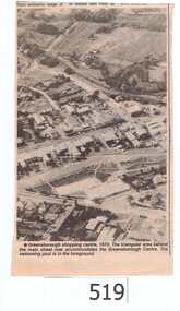
Newspaper clipping, Greensborough shopping centre 1970, 1970_
The photograph is of the centre of Greensborough in 1970, prior to the Greensborough Plaza being built. The Partington farm house, named 'Alwyn' (after Alan and Wyn Partington) can be seen north of the Railway Line. Alan and Wyn had to leave this farm in 1976 - moving to a new house - built by son Gary - at 54 Manatunga Circuit - to make way for the creation of Whatmough Park and development of the Hailes Street-The Circuit-Greensborough Plaza precinct.This is an important visual record of Greensborough before the redevelopment of the late 1970's. It also shows the Whatmough park area when it was still the Partington family farm.A black and white newspaper clipping featuring an aerial photograph.Nilgreensborough streets, greensborough, aerial photograph, 1970, partington, whatmough park, greensborough swimming pool -
 Greensborough Historical Society
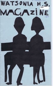
School Magazine, Watsonia High School Magazine 1962, 1962_
Depicts events and attitudes, primarily of students as they go through their adolescent years in the early 1960's. Watsonia High School has now moved to their own buildings in Nepean Street. Annual record of teaching staff, students and events that took place over the year by using both photos and reports. Includes Roll Call section with names of all students.Note: This was the 1st Year of Watsonia's solo publication.20 Pages, Blue cover, Title in black with Illustration of students. Headmaster / Principal - Mr. L.G.MillerOwner's name on coverwatsonia high school -
 Greensborough Historical Society
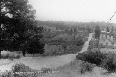
Photograph - Digital image, Greensborough Road, 1900s
An early photograph named as Greensborough Road, Eltham. This was later known as Bridge Street - first reference to same is in The Age 27 November 1906, page 12.Digital copy of black and white photographgreensborough road -
 Greensborough Historical Society
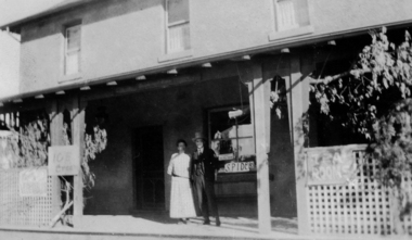
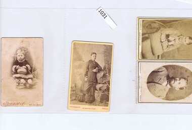
Photographs, Mitchell family, 1882-1883
Studio portraits of John Mitchell [child] Mrs Mary Mitchell, Mrs Mary Mitchell [Top Right] and Henry Mitchell [Bottom Right] and of Hailes Street Greensborough.4 studio portraits, sepia.Names written on back.mitchell family, henry mitchell, john mitchell, mary mitchell -
 Greensborough Historical Society
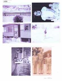
Photograph - Digital Image, Collection of Evans Family photographs, 1946-1949
A collection of photographs of the Evans family living at 11 Anama Street Greensborough. includes Marjorie Evans, Shirley Evans, June Evans, Betty Evans.Digital copy of black and white photographs, printed on A4 paper.Photographs named on back.evans family -
 Greensborough Historical Society
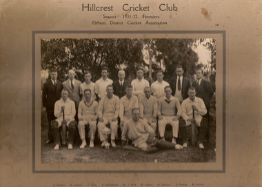
Photograph (copy), Hillcrest Cricket Club: photograph and article, 1931-1932
The Hillcrest Cricket Club is shown in the 1931-32 season. The photograph is named. The photo is accompanied by a handwritten short history of the club by Ray Hooper: "Hillcrest C.C.- Hillcrest Cricket Club was situated between Mountainview Road and … Street at the top of the hill. Where it became flat more or less where River Street met Mountainview Road (straight up). The land was owned by Mr J Ellis (senior) who allowed the local men to make a cricket pitch so they could form a cricket team and enter in the Eltham District Cricket Association (1925-1930). As you can see Mr Ellis Senior (by photo) became president and both his sons played for Hillcrest C.C. My father also played and I can just remember W Mills (Captain), H.Padget, H.Johnson, J.Parks and H.Weidlich (as I got older). Ray Hooper." Copy of group photograph and handwritten article.Group photograph is named.hillcrest cricket club, ray hooper -
![Photograph - Digital image, Marilyn Smith, Fallen Soldiers Memorial [base], 17/12/2013](/media/collectors/4f729f5697f83e03086015b8/items/585b6a88d0ce291268060ca7/item-media/585b6ad4d0ce291268061e6c/item-fit-380x285.jpg) Greensborough Historical Society
Greensborough Historical SocietyPhotograph - Digital image, Marilyn Smith, Fallen Soldiers Memorial [base], 17/12/2013
A recent photo of the base of the Fallen Soldiers Memorial. The Memorial was originally sited in Main Street, moved to Lower Park and eventually to its present position in Greensborough War Memorial Park.This memorial was raised by subscription from residents and bears the names of soldiers who were killed in World War 1.Colour digital photographfallen soldiers memorial greensborough, greensborough war memorial park -
 Greensborough Historical Society
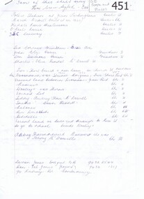
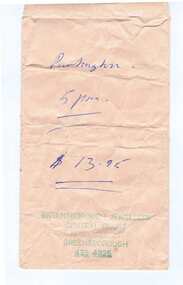
Envelope, Greensborough Jewellers, 1960c
Greensborough Jewellers operated in Main Street in the 1960s-1970s. It was possibly a branch of Busby Jewellers in Preston.Jewelery repair envelope, brown paperCustomer: Partington; Price: $13.95; rubber stamped business name, address and telephone numbergreensborough jewellers, main street shops, central court main street greesborough -
 Greensborough Historical Society
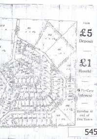
Advertisement, Greenhills Estate, 1923c
The advertisement was used to sell land in the Greenhills area.The plan included details the original street lay out and names applied to them. It also has dimensions of all the blocks of land available and locations and dimensions of easements.A 2 page A3 photoccopy of a real estate advertisement. Nilgreehills, subdivision plan, greensborough -
 Greensborough Historical Society
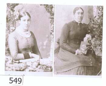
Photograph - Photograph (copy), Prudence Partington and Maria Partington, 1883c
The ladies are from the Partington family. Prudence Partington b 1858, d March 1930. Maria Partington b 1860, d January 1930. Both were unmarried. Both buried at Jessop Street Cemetery.The Partingtons were a pioneering family in the Greensborough district.An A4 black and white copy of 2 Partington sisters.The sisters' names are written in biro on the rear of the card. partington, greensborough cemetery, maria partington, prudence partington -
 Greensborough Historical Society
Photograph Album, Diamond Valley Community Hospital. Redevelopment Program 1990/91. Vol 1, 06/03/1990
The Diamond Valley Community Hospital was established in 1942 in Grimshaw Street Greensborough. This album records the redevelopment/building program in 1990-1991, and includes functions such as 'Turning the Sod' and many photos of buildings under construction. Due to financial circumstances, the hospital closed in 2000. This collection of photo albums is from the 1990s and was collected by staff. Photographs include staff, patients, buildings and functions held for the hospital. Photographs are not named. Albums may be accessed at the GHS Resource Centre. This volume is numbered 6. As the Diamond Valley Community Hospital is now closed, this collection of albums records some of the people involved. Many of the old hospital buildings in Grimshaw Street are still in use as medical rooms and it is interesting to see them being built in 1990.Photo album with dark blue cover. 56 pages, 253 photographs of varying sizes. Title handwritten and pasted on front cover.diamond valley community hospital, greensborough, dvch -
 Greensborough Historical Society
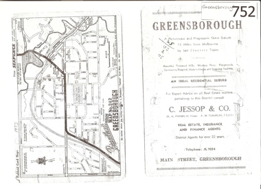
Map, Broadbent's, Greensborough, 1953_
This road map was a part of a Broadbent's Melbourne suburban directory from 1953.It shows the lay out of Greensborough's streets in 1953.It also shows some different street names to those used today. It also features a C Jessop & Co. Real estate advertisementA 1 page photocopy of a road map of Greensborough from 1953.Nilgreensborough, c jessop, broadbents, map no 242, road maps, 1953 -
 Greensborough Historical Society
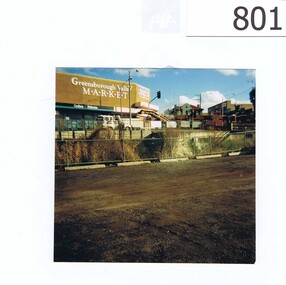
Photograph, Corner Para Road and Main Street Greensborough c1993, 1993_
The photograph shows road works on the corner of Para Road and Main Street Greensborough in 1993.The view also includes the Greensborough Hotel, the valley Buildings and the group of shops on the Para Rd corner named as Greensborough Valley Market. In the foreground it shows the Greensborough railway station car park as unsealed.A colour photograph of a street scene.Nilpara rd, main st, greensborough, road works, valley buildings, greensborough hotel, greensborough valley market -
 Greensborough Historical Society
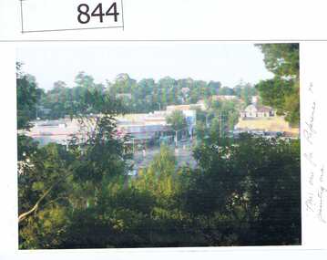
Photographs, Photographs by Maria Barbaro, 2010c
Maria Barbaro is a Greensborough artist. These photographs were taken as studies for her paintings. includes Greensborough Hotel, Bridge and pine, Main Street from Delfin Crescent, Old bridge.Colour photographs, digital prints.Name of photographer on back of photos.maria barbaro, greensborough -
 Greensborough Historical Society
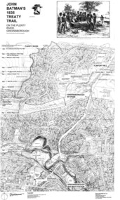
Map, Dennis Ward, John Batman's 1835 Treaty Trail on the Plenty River, 2010_
Map of the Plenty River through Greensborough and surrounding areas, annotated with historic places. Prepared by Dennis Ward, this map shows places of interest with historic markers for a proposed Heritage Trail along the Plenty. This was a joint project of Dennis Ward, Rotary Greensborough and Nillumbik Historical Society.This map shows many places of interest along the Plenty River. Large laminated map, including land subdivisions and street names.plenty river heritage trail -
 Greensborough Historical Society
Map, Green's subdivision of Greensborough, 1860c
This map shows the original subdivision of Greensborough by Edward Bernard Green. Some street names are different to today. This map shows the plan on which the town of Greensborough was based.Copy of early map showing subdivision of Greensborough. Black ink on white paper.edward bernard green, greensborough -
 Greensborough Historical Society
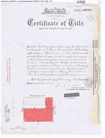
Certificate of Title, Certificate of Title Vol. 3182 Fol. 302, 15/02/1907
Title in the name of Joseph Laidlay of Greensborough, fruitgrower, 14 acres being Lots 7, 8 and 22 on Plan of subdivision 4759, part of Crown portion 17, Parish of Keelbundora County of Bourke, dated 15th February 1907. Northern boundary Greensborough (now Grimshaw) Road, Eastern boundary Henry Street.1 p. colour copy of Titlegreensborough, grimshaw street greensborough, henry street greensborough, joseph laidlay -
 Greensborough Historical Society
Certificate of Title, Supreme Court of Victoria (Probate Division) et al, Certificate of Title Vol. 2567 Fol. 294, Vol. 3134 Fol. 605, 22/05/1895
Title Vol. 2567 Fol. 294 in the name of The Greensborough Estate Company Limited, 164 acres four and a half perches, being part of Crown Portion 17 Parish of Keelbundora, County of Bourke. Dated 22nd May 1895. Northern boundary Greensborough Road (now Grimshaw Street), Southern boundary Nell Street, Eastern boundary Plenty River, Western boundary road (now named McDowell Street); Title Vol. 3134 Fol. 605 in the name of Adolphe Frederic Seelenmeyer, land as described above, LP 4759 and transfers and other instruments to 9 March 1948Folder containing two Certificates of Title (3p. + 9 p.) and twenty pages of miscellaneous documents, including historical summary, brief biography of A. F. Seelenmeyer, two Death Certificates and photocopied extracts from probate documents, as listed in table of contents, ed. by Peter Simmenauergreensborough, greensborough estate company limited, grimshaw street greensborough, plenty river, nell street greensborough, mcdowell street greensborough, adolphe frederic seeley, formerly seelenmeyer, adolfe frederic seelenmeyer -
 Greensborough Historical Society
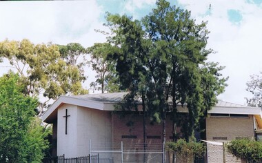
Photograph - Digital image, Frank Solomon, Greensborough: Methodist Church at 37 Grimshaw Street, 2010c
The Methodist Church moved from Main Street to this location in Grimshaw Street in the 1970s. It is now named the Living Faith Church.Digital copy of colour photographgrimshaw street greensborough, greensborough methodist church, living faith church -
 Greensborough Historical Society
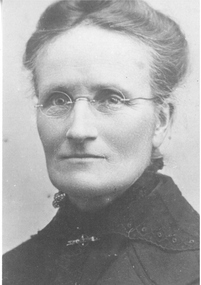
Photograph - Digital image, Bruce McDowell, Jane Henrietta Coventry, 1863o
Photograph of Jane Henrietta Coventry nee Spencer 1863-1940 with details of her husband and 10 children. Jane and Henry Coventry's family included two champion AFL footballers, Syd and Gordon Coventry. Coventry Street [Montmorency] is named after her son Tom Coventry, who lived in the area.Photograph and notes, 2 p. black and whitecoventry family -
 Greensborough Historical Society
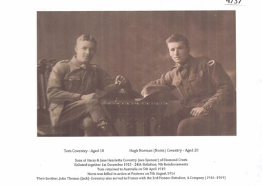
Photograph - Digital image, Tom and Hugh (Norm) Coventry, 1915, 1915_
Photograph of Hugh Norman (Norm) Coventry age 20 and his brother Tom age 18 after their enlistment 1 December 1915. Coventry Street [Montmorency] is named after Tom Coventry, who lived in the area.1page, sepia photograph and notescoventry family -
 Greensborough Historical Society
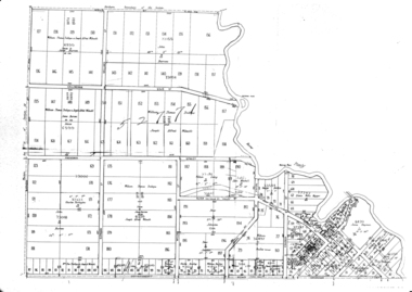
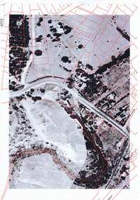
Aerial Photograph, Greensborough aerial with property overlay, 1945_
... greensborough plenty river Street names and some property numbers ...Enlargements of section of 1945 aerial survey photographs of central Greensborough, with property overlay boundaries and some street numbers by Noel WithersTwo photocopied enlargements with property overlay markingsStreet names and some property numbers. Overlays by Noel Withers.greensborough, plenty river