Showing 61 items matching "history of a street precinct"
-
 Glenelg Shire Council Cultural Collection
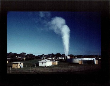
Photograph, Photograph - Bore, n.d
Glenelg Shire Council RecordsView of West Portland Bore and Precinct -
 Glenelg Shire Council Cultural Collection
Souvenir - Fridge Magnet - Casterton, Victoria, n.d
Unknown -
Glenelg Shire Council Cultural Collection
Photograph - Photograph - Harbour Portland, 1960-1970
Portland Historic PrecinctBlack and white photo. Julia Street, Portland looking east to harbour. Vessel berthed either side of Railway Pier. Photo glued on to card.Front: Julia St. Portland 'Nicholls' Printed bottom of photo. -
 Eltham District Historical Society Inc
Photograph, Eltham Justice Precinct, cnr Main Road and Brougham, Street, Eltham, c.Oct. 2001
courthouse, Eltham, Eltham Courthouse, Eltham Justice Precinct, local history centre, Main Road, police residence, Police Station Four colour photographs 10 x 15 cm -
 Eltham District Historical Society Inc
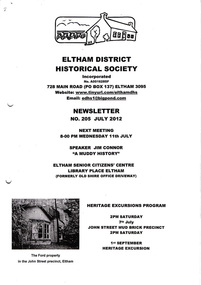
Newsletter, Newsletter, No. 205 July 2012
... : A Muddy History • July Meeting • July Excursion – John Street Mud...: A Muddy History • July Meeting • July Excursion – John Street Mud ...Contents: • Next meeting, guest speaker; Jim Connor: A Muddy History • July Meeting • July Excursion – John Street Mud Brick Precinct • Kooringorama – An Incomplete History • Eltham’s War Memorials by Harry Gilham • And Also The Shire of Eltham Historical Society was formed in October 1967. The first newsletter of the Society was issued May 1978 and has been published continuously ever since on a bi-monthly basis. With the cessation of the Shire of Eltham in late 1994, the Society's name was revised to Eltham District Historical Society and this name first appeared with issue No. 103, July 1995. The collection of the Society's newsletters provides a valuable resource on the history of the Society's activities, office bearers and committee members, guest speakers and subjects of historical interest pertinent to the former Shire of Eltham and the Eltham District.A4 photocopied newsletter distributed to membersnewsletter, eltham district historical society, shire of eltham historical society -
 Eltham District Historical Society Inc
Photograph, Tom Prior, Police Station and Residence, Maria Street, Eltham, c.1900
Situated near the top of what was known as 'Policeman's Hill' according to Miss Ivy Reynolds, neice of the photographer, Tom Prior. From the left, Eltham Court House, Police Residence and Police station on Main Road and corner of Brougham Street. These buildings formed part of Little Eltham and still stand (without the front fence) today though the Police Station was demolished in 1986 due to termite damage. A replica was built circa 1989. The institutions of law and order in Colonial Victoria included the police, courts and prisons. The 1852 report of the Snodgrass Select Committee appointed to "identify the policing needs of the colony” noted there existed seven independent police forces that did not co-operate or regularly communicate. Following the committee's report all these police entities were merged into the Victoria Police, founded on 8 January 1853, to implement law and order responsibilities throughout the Colony of Victoria. The Eltham Courthouse (1860) and adjacent Police Residence (1859) formed a justice precinct established in the immediate aftermath of the 1852 police inquiry and the effects of the gold rush. The physical presence of these buildings, in the centre of the early Eltham township, defined centralised control over law and order. In the early days the Police Constable in charge would conduct his duties travelling around the district by horse; a stable was located at the rear of the residence. At times the horse would be grazed on the paddocks across the road. Horseshoes were forged by the blacksmith beside the Courthouse on the high side of “Policeman’s Hill”. Along with the stable, there was a two-cell bluestone lockup where prisoners were held awaiting trial in the adjacent Courthouse. Their meals were usually provided by the policeman’s wife or from the hotel just up the road. With the arrival of the railway in 1902 the town centre gradually shifted towards the railway station. The Police Station and operations were moved into the town centre in 1961 to a renovated house in Pryor Street, which was later replaced by the current Police Station. From 1961-1981 the residence was occupied by the Vermin and Noxious Weeds Destruction Section of the Department of Crown Lands and Survey. Prior to August 1967 the former Police Station was dragged to the rear of Police Residence to make way for the construction of a driveway and access from Main Road. The building was placed on the site of a former Scullery and modified for Lands Department use. In 1981 the Shire of Eltham took over management of the former Police Residence in Eltham. It remained unoccupied for a period whilst its future was discussed in Council. It was then used for a community job creation scheme until 1985. In 1985 the Shire of Eltham Parks and Environment occupied the residence. Council improved the driveway but later added a second rear access from Brougham Street due to the dangerous nature of the Main Road entrance. Additionally, a rear toilet facility between the Police Residence and the relocated former Police Station, which was doubling up as a lunchroom. Council also commenced discussions to re-establish a replica Police Station. Around November 1986 the former Police Station was demolished; believed to have been suffering termite damage. About 1989, after some years of discussion, a replica Police Station was built, based on photographs, to act as a lunchroom and meeting room for the Parks and Environment staff and volunteers doing community service. In 1996 Eltham District Historical Society held discussions with Nillumbik Shire Council commissioners throughout the year regarding a home for the Society. A proposal was put forward by the Society in October to occupy the former Police Residence. In March 1997 Eltham District Historical Society gained access to former Police Residence and on July 12, 1998, moved into its Local History Centre. In July 2018, Eltham District Historical Society gained access to the replica Police Station (which had been used as a music library and storage for the Eltham Concert Band) for use as part of regular heritage tours for schools and community-based groups.This photo forms part of a collection of photographs gathered by the Shire of Eltham for their centenary project book,"Pioneers and Painters: 100 years of the Shire of Eltham" by Alan Marshall (1971). The collection of over 500 images is held in partnership between Eltham District Historical Society and Yarra Plenty Regional Library (Eltham Library) and is now formally known as 'The Shire of Eltham Pioneers Photograph Collection.' It is significant in being the first community sourced collection representing the places and people of the Shire's first one hundred years. The Reynolds family were early settlers in Research. The Reynolds/ Prior collection of photographs were taken by Tom Prior, the maternal uncle of Ivy Reynolds, around 1900 and the 60 photos in the album give a fine overview of many of the landmarks of Research and Eltham over 100 years ago. lvy lived in the family home for many years at 106 Thompson Cres Research. Ivy's father, Ernst Richard Reynolds and grandfather, Richard Reynolds, lived at the same address. Ivy's father Richard worked for Mr. Trail on his property in Research. Reynolds Road is named after the family. Mr Tom Prior (wife Eva) worked at the Melbourne zoo. He was very innovative and made his own camera, using the black cloth hood to exclude the light. The photographs are a reminder of the rural nature of Research and Eltham and its rich heritage.Digital imagechildren, court house, courthouse, eltham, eltham district historical society, eltham justice precinct, little eltham, local history centre, main road, police residence, police station, reynolds prior collection, sepp, shadow, shire of eltham pioneers photograph collection -
 Bendigo Historical Society Inc.
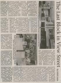
Newspaper - JENNY FOLEY COLLECTION: THE LAST BLOCK IN VIEW STREET
Bendigo Weekly from Friday, August 17, 2001. The last block in View street - by Edith Lunn. The previous articles on View Street in its heyday as a shopping precinct dealt with the two blocks from Barnard Street to McKenzie Street. In the last article looks at the remaining block from McKenzie to View Point. The clip is in a folder.newspaper, bendigo, bendigo weekly -
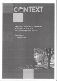 Bendigo Historical Society Inc.
Book - WHITE HILLS AND EAST BENDIGO HERITAGE STUDY 2016
One hundred twenty five loose pages stapled together titled: Context, people, place, heritage. White Hills and East Bendigo Heritage Study 2016 Vol.2: Place and Precinct citations. Final Citations 12 February, 2016. Prepared for City of Greater Bendigo.bendigo, council, heritage study -
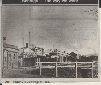 Bendigo Historical Society Inc.
Newspaper - JENNY FOLEY COLLECTION: ART PRECINCT
Bendigo Advertiser ''The way we were'' from 1999. Art precinct: View Point in 1858.newspaper, bendigo advertiser, the way we were -
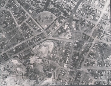 Bendigo Historical Society Inc.
Photograph - HARRY BIGGS COLLECTION: AERIAL PHOTO OF EAGLEHAWK
Photograph. Harry Biggs Collection. A black & white overhead photo of Eaglehawk. It clearly shows the football ground, Canterbury Park, Town Hall precinct.place, streetscape, aerial view of eaglehawk, harry biggs collection, aerial photo of eaglehawk -
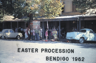 Bendigo Historical Society Inc.
Slide - BENDIGO EASTER PROCESSION, 1962
Slide. Bendigo Easter Procession. The Old Chinese precinct.slide, bendigo, bendigo easter procession., bendigo easter procession. -
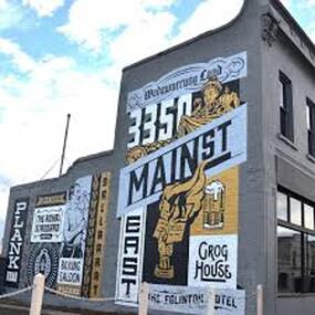 City of Ballarat
Artwork, other - Public Artwork, Travis Price, Main Road Mural by Travis Price, May 2018
Whilst my main focus for the artwork design was on the Hotels on Main Road, I felt there was an opportunity to tell a broader story of Main Rd and combine/include some interesting pieces of information from many stages of the history of Main Road. Considering that at one point in time there would have been at more than six hotels in this very short section of street….there’s no doubt Main Rd was an epicentre of communication and festivities for the Goldfields of Ballarat. “No matter what luck he had, every miner needed supplies, food and something to entertain him when he was not searching for gold.” Described as being an overcrowded jumble of muddy streets loosely arranged around mining camps...and loud, muddy, colourful and sometimes illicit. I wanted the artwork composition to consist of overlapping images and text to reflect this sense of hustle and bustle. Main Road Mural tells the broader story of the history of Main Road in Ballarat. In 2018, the City of Ballarat commissioned local Ballarat artist Travis Price to create an artwork to align with the Main Road Revitalisation Project and deliver a key component of the storytelling (heritage interpretation) project that spans the length of the shopping precinct. The artwork is featured on a prominent site in the shopping precinct of main road and tells the story of Main Road through depicting key timeline events. Main Road, as its name suggests, was one of the main entries to the mining areas of East Ballarat. It had several names: Main Street before 1858, Plank Road between 1858 and 1868 and Main Road from 1868 onwards. The centre of mining life, it was crowded, prosperous, raucous and dirty. Painted mural on shop wall in Main Road, BallaratBallaarat, Gold Fever, The Royal Standard Hotel, Flood, Boxing Saloon, Plank Road, Kulin Nation, 3350, Election, East, Grog House, The Scandinavian Hotel. Images; Chinese lantern, Pick & Shovel, Miners Licence burning.main road history, ballarat hotels, gold fever, wadawurrung, kulin nation -
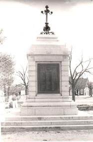 Hume City Civic Collection
Photograph, post 1972
The Sunbury War Memorial is situated on a triangular section of land which was once at the intersection of Barkly and Stawell Streets. The precinct is also the site of the Rupertswood Gun and the Starkey Fountain. All are important historical exhibits related to Sunbury's history.A black and white photograph of a front view of the Sunbury War Memorial. The memorial has been placed on 3 steps at the base with a metal tablet set in a stone surround. There is a decorative metal pole at the top of the memorial. St. Mary's Church is in the background.war memorials, village green, st. mary's church, george evans collection -
Unions Ballarat
Camp Street, Ballarat from Eureka to Federation : a guide to its history and buildings, 2001
A guide to the history of Camp Street Ballarat and its historical buildings. Camp Street has been the location of Unions Ballarat since 1887 - a chapter of the book is dedicated to Trades Hall - and was the home of the former labour newspaper, the Evening Echo. Camp Street was the site of the government camp at the time of the Eureka Stockade. Camp Street is now recognised as an Arts and Education precinct within the city of Ballarat. Headings: Gold fever The CAMPSTREET Project Titanic Bandstand Old Ballarat Free Library Complex "Point to the sky" "Perseus" Former government offices and court house Old Ballarat Court House Alfred Deakin Place Old Police Station (Ballarat Fine Art Gallery) Ballarat Fine Art Gallery Millennium Extension Bluestone Warehouse (Pratt's Warehouse) Old YMCA building Wilson House Ballarat Office Systems Ballarat Trades Hall The ANA Building Freemason's Hall Former Ballarat Trustees and Executors Agency Co. Ltd. Restaurant Former Evening Echo Building Ballarat Savings Bank (now The Ballarat Business Centre) Significant to the history of architecture and social life within the city of Ballarat. Direct relevance to Unions Ballarat building.Book; 48 pages. Cover: blue background; colour photos and maps pertinent to Ballarat; white lettering; title and compiler's name. btlc, ballarat trades hall, ballarat trades and labour council, evening echo, ballarat savings bank, ballarat business centre, freemason's hall - ballarat, ana building - ballarat, ballarat - camp street, wilson house - ballarat, ballarat office systems, ymca building, pratt's warehouse - ballarat, ballarat fine art gallery, old police station - ballarat, alfred deakin place, old courthouse - ballarat, perseus, point to the sky, old ballarat free library complex, titanic bandstand, campstreet project, gold mining - ballarat, architecture - history - ballarat -
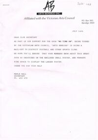 Bendigo Historical Society Inc.
Document - MERLE HALL COLLECTION: VARIOUS ARTS BENDIGO OUTWARDS CORRESPONDENCE
Various Arts Bendigo Outwards Correspondence - To: Mailout to District Football and other clubs for show ''No Time On''; Steve Gibbons MP re nomination of Merle Hall for a Certificate of Recognition (for outstanding contribution to AB and the community (July 2001); Cr Weston Mayor COGB, re AB support for Council's application for funding for Bendigo Arts Precinct- Art Gallery Project 1997; 1998/199 Report summary of AB activities calendar for 1999; Roman Rudnytsky re confirmation of concert date Aug 1997; David Scheel re performance 1997; Dr I McBean, University College of Northern Victoria, re re Bluthner piano 'Loan arrangement'' and restoration planned (1991); ''Alexandra''?? March 1991 re performance Agreement and directions; -
 Bendigo Historical Society Inc.
Ephemera - Invitation, 2015
Originally on the site of the Government Camp, the Sandhurst prison was built in 1863, when it housed both male and female prisoners. In 1972 it was renamed the Bendigo Prison, a medium security prison for male inmates. It closed in 2004 and was redeveloped as an arts and performance precinct named "Ulumbarra" (meeting place.Two invitations to the Gala Opening of Ulumbarra Theatre, Bendigo on 17/04/2015ulumbarra theatre, old bendigo gaol, opening -
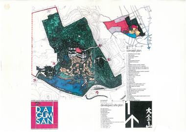 Bendigo Historical Society Inc.
Document - Dai Gum San Concept Plans - Chinese Tourist Village Bendigo Victoria, 1980s
During the first goldrush of the 1850s, Chinese miners referred to the Bendigo region (then Sandhurst) as Dai Gum San 大金山 - literally 'Big Gold Mountain'. The Golden Dragon Museum is situated in the city of Bendigo, Victoria, Australia. The museum is dedicated to the culture and history of Chinese Australians, particularly in the region. Built on the historical site of one of Bendigo's Chinatowns, the museum's precinct also includes Chinese Gardens and a temple to Kuan Yin. Through the museum accreditation program, it was the first accredited museum in Victoria and opened in 1991. These plans are the original plans before the the Golden Dragon Museum was built on its current site.Dai Gum San Concept Plans - Chinese Tourist Village Bendigo Victoria - 4 Sheets in colour by Stephenson and Turner Victoria Architects and Planners Sheet 1 Concept Plan and Developed Site Plan Sheet 2 Arts and Crafts Buildings Sheet 3 Restaurant, Historical Museum and Temple Complex Sheet 4 Motelhistory, bendigo, eaglehawk, chinese, chinese museum, dai gum san -
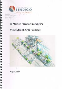 Bendigo Historical Society Inc.
Book - CITY OF GREATER BENDIGO: MASTER PLAN FOR BENDIGO'S VIEW STREET ARTS PRECINCT AUGUST 2007, August 2007
City of Greater Bendigo Document ''A Master Plan for Bendigo's View Street Arts Precinct. August 2007. Don Goldsworthy - Architect and Urban Designer, Positive Solutions Arts Facilities and Business Planning, Cardno Grogan Richards Engineering and Traffic Management. Booklet 47 Pages.City of Greater Bendigobendigo, planning, view street arts precinct, http://www.bendigotourism.com/things-to-do/bendigo-arts-culture/view-street-arts-precinct -
Kew Historical Society Inc
Archive (Sub-series) - Subject File, Kew Court House - 2000-2005, 2000
Various partiesReference, Research, InformationSecondary Values (KHS Imposed Order)Subject file containing information about the heritage significance of the Kew Court House (and Police Station) in High Street, Kew. Most of the file contains correspondence between a number of interested parties including the Kew Historical Society which was leading the campaign to have the building/precinct preserved and used for community purposes. Letters and submissions include those from the Department of Treasury & Finance, Ray Tonkin (Heritage Victoria), Dr. Robert Dean MLA, Judith Voce, Hon David Davis MLC, John Lenders MP, Hon John Thwaites, Andrew McIntosh MLA and officers of the Kew Historical Society. The file also contains records of interview and memos and meeting minutes relating to the campaign.kew - history, kew court house, kew police station, heritage campaigns - kew (vic)kew - history, kew court house, kew police station, heritage campaigns - kew (vic) -
![Victorian era cottage, Derby Street [Kew]](/media/collectors/550653872162f11fb04854aa/items/658f5772101c4283c6ae47ff/item-media/658f57e4101c4283c6ae493a/item-fit-380x285.jpg) Kew Historical Society Inc
Kew Historical Society IncPhotograph - Victorian era cottage, Derby Street [Kew], c. 1965
The current site of the Kew Recreation Centre in High Street Kew previously housed the Kew Depot on the corner of Disraeli Street. In nearby Derby Street, a number of original Victorian era buildings were gradually replaced due to development of the Baths precinct and commercial development.This work forms part of the collection assembled by the historian Dorothy Rogers (1905-1973), donated to the Kew Historical Society by her son in 2015. The manuscripts, photographs, maps, and documents were sourced by her from both family and local collections or produced as references for her print publications. Many were directly used by Rogers in writing ‘Lovely Old Homes of Kew’ (1961) and 'A History of Kew' (1973), or the numerous articles on local history that she produced for suburban newspapers. Most of the photographs in the collection include detailed annotations in her hand. The Rogers Collection provides a comprehensive insight into the working habits of a historian from the 1960s to the 1970s. Small single fronted cottage in Derby Street, Kew. The weatherboard cottage has a block fronted facade, and a Victorian verandah with cast iron lace.Annotation verso: "House in Derby St., next to Kew Baths (Demolished?)"dorothy rogers, derby street (kew), victorian houses -- kew (vic.) -
![Victorian era cottage, Derby Street [Kew]](/media/collectors/550653872162f11fb04854aa/items/658f7ef19239cf6fd436d1fd/item-media/658f7f019239cf6fd436d25f/item-fit-380x285.jpg) Kew Historical Society Inc
Kew Historical Society IncPhotograph - Victorian era cottage, Derby Street [Kew], c. 1965
The current site of the Kew Recreation Centre in High Street Kew previously housed the Kew Depot on the corner of Disraeli Street. In nearby Derby Street, a number of original Victorian era buildings were gradually replaced due to development of the Baths precinct and commercial development.This work forms part of the collection assembled by the historian Dorothy Rogers (1905-1973), donated to the Kew Historical Society by her son in 2015. The manuscripts, photographs, maps, and documents were sourced by her from both family and local collections or produced as references for her print publications. Many were directly used by Rogers in writing ‘Lovely Old Homes of Kew’ (1961) and 'A History of Kew' (1973), or the numerous articles on local history that she produced for suburban newspapers. Most of the photographs in the collection include detailed annotations in her hand. The Rogers Collection provides a comprehensive insight into the working habits of a historian from the 1960s to the 1970s. Small single fronted cottage in Derby Street, Kew. The weatherboard cottage has a block fronted facade, and a Victorian verandah with cast iron lace.dorothy rogers, derby street (kew), victorian houses -- kew (vic.) -
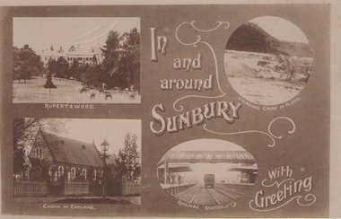 Sunbury Family History and Heritage Society Inc.
Post Card, In and around Sunbury with Greeting
The post card is one of a set that were produced by Chris Christainsen, who had a pharmacy in Sunbury and was also a photographer. The four photos featured on the card are the Rupertswood Mansion, St Mary's Church of England, Jacksons Creek in floods ands Sunbury Railway station.The buildings and places featured on the card are of historical significance in the Sunbury town precinct. A post card with four sepia photographs of interesting sites which can be seen in the Sunbury township. IN AND AROUND SUNBURY WITH GREETING. christainsen, chris., rupertswood mansion, st. mary's church of england., jacksons creek, sunbury railway station -
 Sunbury Family History and Heritage Society Inc.
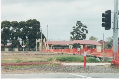
Photograph, c1999
The open are in the foreground was part of railway land on the west side of Sunbury Station along Horne Street. The initial preparations to develop the area into a commercial and entertainment precinct were just commencing. The development that took place on this site was indicative of the growth that was taking place in Sunbury in the early 2000sA coloured photograph of an open area feed off with temporary netting in preparation for construction work. A set of traffic lights are on the RHS of the photograph and a station is in the middle distance.sunbury railway station -
 Sunbury Family History and Heritage Society Inc.
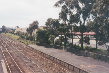
Photograph, 25th July 1995
The photograph of Sunbury Station was taken from the pedestrian bridge and is looking north to take in the Sunbury Square shopping centre buildings and the bus terminal which are on the Platform 1 or east side of the station.During the 1990s much development took place in Sunbury and the station precinct became a commercial hub.A coloured photograph of a railway station and a Coles Supermarket in the middle distance as well as a bus terminal. -
 Port Fairy Historical Society Museum and Archives
Functional object - Straight Jacket
Found in a cupboard in the Port Fairy Police station. Presumably used by the Local police for restraining difficult prisoners.An item of significance to the precinct that the museum and archives occupies. A glimpse into the not so pleasant part of being a policeman or prisoner in the late 1800's to early 1900's.Canvas straight jacket with eyelet holes in back for lacing jacket closed appears to have been made by a sailmaker - has patch on left front breast - various brown stainslocal history, essential services, police, restraint, jail, prison -
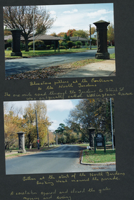 Friends of Ballarat Botanical Gardens History Group
Photograph - Digital image - jpg, Album photos of entrance pillars
Two colour photographsballarat botanical gardens precinct, entrance pillars, ballarat north gardens reserve -
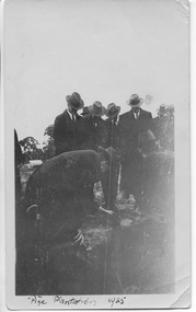 Tarnagulla History Archive
Photograph: Planting ceremony to commence Pine Plantation, Tarnagulla, June 1925
From tarnagulla.org by David Gordon: "The plantation is bounded by King, Gladstone and Welsh Streets and on the east by the drainage channel. It was planted up and opened in June 1925. It is located on the massive sand heap of R.W.Hammond's quartz crushing battery, and the plantation served to enhance the appearance of a large-scale mining precinct which was by 1925 seen as an eyesore from the bygone mining days". Donald Clark Collection. A monochrome photograph of a group of men in suits and hats planting seedlings as part of a planting ceremony to commence the Pine Plantation, Tarnagulla.tarnagulla, trees, mining, pine plantation, the pines, landmarks, children -
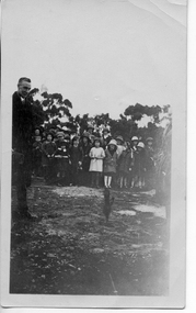 Tarnagulla History Archive
Photograph: Children at planting ceremony to commence Pine Plantation, Tarnagulla, June 1925
From tarnagulla.org by David Gordon: "The plantation is bounded by King, Gladstone and Welsh Streets and on the east by the drainage channel. It was planted up and opened in June 1925. It is located on the massive sand heap of R.W.Hammond's quartz crushing battery, and the plantation served to enhance the appearance of a large-scale mining precinct which was by 1925 seen as an eyesore from the bygone mining days". Donald Clark Collection. A monochrome photograph of a group of children observing a ceremony to commence the Pine Plantation, Tarnagulla.tarnagulla, trees, mining, pine plantation, the pines, landmarks, children -
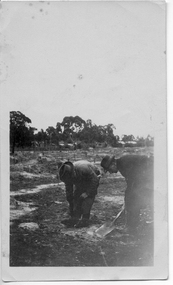 Tarnagulla History Archive
Photograph: Planting ceremony to commence Pine Plantation, Tarnagulla, June 1925
From tarnagulla.org by David Gordon: "The plantation is bounded by King, Gladstone and Welsh Streets and on the east by the drainage channel. It was planted up and opened in June 1925. It is located on the massive sand heap of R.W.Hammond's quartz crushing battery, and the plantation served to enhance the appearance of a large-scale mining precinct which was by 1925 seen as an eyesore from the bygone mining days". Donald Clark Collection. A monochrome photograph of two men planting seedlings during a ceremony to commence the Pine Plantation, Tarnagulla.tarnagulla, trees, mining, pine plantation, the pines, landmarks -
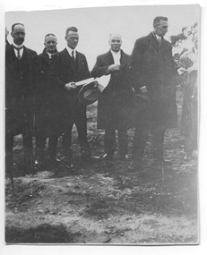 Tarnagulla History Archive
Photograph: Planting ceremony to commence Pine Plantation, Tarnagulla, June 1925
From tarnagulla.org by David Gordon: "The plantation is bounded by King, Gladstone and Welsh Streets and on the east by the drainage channel. It was planted up and opened in June 1925. It is located on the massive sand heap of R.W.Hammond's quartz crushing battery, and the plantation served to enhance the appearance of a large-scale mining precinct which was by 1925 seen as an eyesore from the bygone mining days". Donald Clark Collection. A monochrome photograph of a group of men during a ceremony to commence the Pine Plantation, Tarnagulla. Handwritten inscription on reverse names subjects as (L-R) 'Dad (Foth) on left hand side' and 'Mr [Owen] Jones, Chairman of Forest Commission Vict., Mr Johns District Schools Inspector, Mr McRae Chief Inspector of Forestry of Education Department'.tarnagulla, trees, mining, pine plantation, the pines, landmarks, forestry commission, owen jones, fotheringham