Showing 82 items matching "john barber"
-
 Eltham District Historical Society Inc
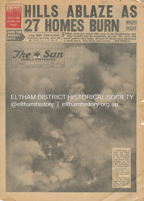
Newspaper - Newspaper articles, Sun News-Pictorial, Hills Ablaze As 27 Homes Burn, The Sun News-Pictorial, Monday, January 15, p1, 1962
Various news articles pertaining to the January 1962 Victorian bushfires in the Dandenong and Healesville districts. • Hills Ablaze As 27 Homes Burn; Night Fight, p1 (Illust.) • Yarra Glen, Healesville Saved; Fire into main street, p2 (Illust.) • Flare-up at Montrose, p2 • 20 scouts flee as fire sweeps camp, p2 • Gaol for fires today …, p2 • Timber lost, p2 • Heathmont home lost, but others saved, p2 • The desperate fight, p3 (Illust.) • Rubbish fire got away; Basin blaze, p3 • Panorama of destruction, p3 • Fire Captain Killed; 7 road deaths at week-end, p5 (Illust.) • Heartbreak, ruin as … Fire Sweeps the Hills, pp18-19 .(Illust.) • Tea; they made it for the fire fighters, pp18-19 (Illust.) tom fielding collection, victorian bushfires - 1962, victorian bushfires – 1962, dandenongs, the basin, yarra glen, healesville, montrose, chum creek, scouts, australian logging co., a.w. larkins, heathmont, vermont, r. pearson, mike ryan, vic parker, c.g. wilson, hillside farm, clive brewer, ron anderson, mrs anderson, mt dandenong, healesville rural fire brigade, malcolm barber, yarra flats, r. bicknell, ferny creek, blue hills gues house, heatherset road, sassafras, olinda, presbyterian manse, john gorie, janice gorie, lynette gorie, jacky wilson, patricia cortie -
 Nhill Aviation Heritage Centre
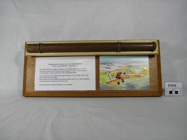
Memorabilia - Joystick, From Tiger Moth crash, c. 1940
The joystick has been held by the Barber family since the crash in 1945. It had been kept as a momento to the witnessing of the incident involving an aeroplane from the Nhill Air Training School. In recent times the joystick has been mounted on a display base and loaned to the Nhill Aviation Heritage Centre to add to the awairness of this event. This is the only remains of this aircraft known to existSection of a wooden aircraft joystick, broken off at the base. Made of turned and polished wood with a turned handle section approx 100mm at the top. Mounted on a wooden display base with two brass retaining rings. Display base has information in text and description artwork of the aircraft. Inscription "MEMORABILIA from R.A.A.F. FLYING SCHOOL / NHILL AERODROME World War II"air crash, joy stick, propodollah, barber, tiger moth, a17 751, keith scholfield, lac john considine -
 Greensborough Historical Society
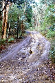
Slide - Photograph, John Ramsdale, Barbers Creek, Mernda: Slide 6, 1990s
Photograph shows washed out bush track with gully erosion at Barbers Creek, Mernda.Part of the John Ramsdale collection of slides and audio visual material.Colour photograph scanned from slide.No maker's marks. No caption on slide.erosion, barbers creek mernda -
 Eltham District Historical Society Inc
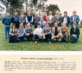
Photograph, Staff Photo, Building, Health and By-Laws Department, Shire of Eltham, July, 1987 (with names), 1987
Top Row, from left - Horst Woitassek, Barry Woodhouse, Danny Hick, Trevor Sorenson, Charles Harris, Marie Daye, Peter Sturtevant, Ian Leach, Dorothy Heywood, Gary York. Bottom Row, from left - Sue Hanna, Lyn Warburton, Stephen Gorst, Frank Tyler, Brian Wright, Bill Barber, Dave Lovatt, Helen Hickey, Carol Woodhams. (Staff not present - Lyn Glassford, Margaret Hosking, Sue Renehan, John Duffy, Deanne Brown, Dr. Hewitt, Alex Best).Two colour photographs, laminated, one with typed list of names 2 copies 22.5 x 27 cm laminated (12.5 x 20 cm photo)Originally contained in an envelope with handwritten note on enveloe to Allan Baker dated 14 Dec 1987 "Enclosed for your use are staff photos of all departments. I've given each Champion of Committees copies for all their respective Councillor photos of Depts reporting to each committee. Outdoor staff photos will be taken next week and I'll make those available as soon as possible. Cheers (Undecipherable)"shire of eltham, council staff -
 Kiewa Valley Historical Society
Papers - History of the Barber Family and Gundowring, Barber Family History
... the Barber family homestead. John McDonald, Schools, St Andrew's... in Gundowring Families in the Kiewa Valley Barber Family John McDonald ...The Barber family arrived in Australia in 1803. Charles Henry Barber took up Gundowing in 1838. The history includes the Barber family homestead. John McDonald, Schools, St Andrew's Church, Richard Goldsworthy 1843, John and George Larkin, Geering,;David, Joseph and Arthur Ford , Richard Barton, Thomas Carrol, Mrs E. Bell, John Arundel, Tobacco, History of Gundowring and its familiesWhite roll of computer paper - old style with 'tear off' strip of holes along each side enabling easy tearing.Typed continually including over the join (also perforated) of the 10 pages. Includes many headings re Families living in the area. Perforations on sides torn off to enable easy storing.On the back of the Title written in blue pen - 'Historical Society of Kiewa Valley / A History of the /Kiewa Valley.' Written in aqua pen - 'Barbour (sic) Family / Historyfamilies in gundowring, families in the kiewa valley, barber family, john mcdonald, richard goldsworthy, john and george larkin, geering, ford brothers, richard barton, thomas carrol, mrs e. bell, john arundel, tobacco -
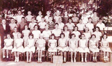
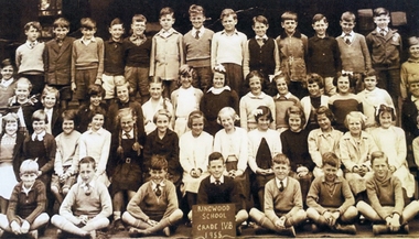
 Ringwood and District Historical Society
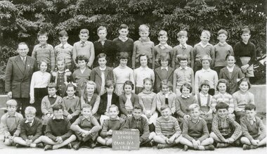
Photograph, Ringwood State School -Class photograph - Grade 4A, 1958
Black and white photograph - Grade 4A,1958"Attached to photograph" Back Row- L to R: Greig Hutchins, Graham Nichols, ?, ?, Jim Page, ?, Ross Warne, Wayne Griffin, ?, ?, ?, ?. 2nd Row - L to R: ?, (?) White, Helen Cannon, Jean Ritch, ?, Laurel Adams(?), Julie Mynott, (?) Baldwin, Lynette Harris(?), Ruth Tozer. 3rd Row - L to R: Christine Brown, Barbara Ryan, ?, Denise (?), Betty Jacobs, Meredith Brown, Lynette Bangay, ?, Shirley Rodney, Ruth Barber, ?, ?. Front Row - L to R: ?, Denis (?), John Carpenter, Russell Sinclair, George Rechnitzer, Bruce Stephens, ?, Taki Polinakas, ?. Teacher: Mr Remeryi. -
 Ringwood and District Historical Society
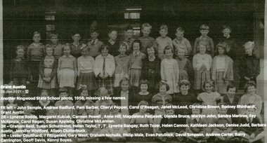
Photograph, Ringwood State School - Grade 2B,1956
Black and white photograph - Grade 2B, 1956."Attached to photograph" Back Row-L to R: Lester Coulthard, (?) Fitzgerald, Gary West, Graham Nicholls, Philip Male, Evan Patullock, David Simpson, Andrew Carter, Barry Carrington, Geoff Davis, Kenny Boyes. 2nd Row-L to R: Graham reid, Susan Schurmann, Helen Taylor, ?, ?, Lynette Bangay, Ruth Tozer, Helen Cannon, Kathleen Jackson, Denise Judd, Barbara Austin, Jennifer Whitford, Alison Clutterbuck. 3rd Row-L toR: Lynette Rodda, Margaret Kubiak, Carmen Powell, Anne Hill, Magdalena Padjasek, Glenda Bruce, Marilyn John, Sandra Martron, Fay McKenzie, Carol Regan, Susan Appleby, Christine McLennan. Front Row-L to R: John Semple, Andrew Radford, Pam Barber, Cheryl Pepper, Carol O'Reagan, Janet McLeod, Christine Brown, Rodney Rhinhardt, Grant Austin. Teacher: -
 Ringwood and District Historical Society
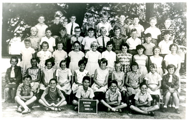
Photograph, Ringwood State School - Grade 5C, 1963
Black and white photograph - Grade 5C, 1963."Attached to photograph" Back Row- L to R: Ron Saines, ?, ?, Ian Carrington, Ian McCall, Roger Harris, ?, Grant Nichol, Howard Archer. 2nd Row- L to R: Bruce Barber, David Kimberley, ?, Mark Wells, Tony Martin, Makus Dash, Wayne Walton, ?, ?, ?. 3rd Row- L to R: Ann Downey, Christie Schrum, Meg Flowers, Robyn Westthorpe, ?, Whilema Coenders, Grace King, Rosemary Weaver, Ann Hagar. Front Row- L to R: Lynda Wilis, Linda (?), Debbie Sylvie, Elvena Crawford, Christine Smith, ?, Jenny Buchanan, ?, Annette Smeaton, Ann Logan. On Ground: Terry Bacon, ?, John Grayling, Dale Ryan. Teacher: Miss Enterkin. -
 Federation University Historical Collection
Newsletter, Ballarat University College Newsletter, Nos 1-9, 1990
Ballarat University College was affiliated with the University of Melbourne. It was previously Ballarat College of Advanced Education, and later became the University of Ballarat. John Sharpham was the Director of the Ballarat College of Advanced Education. In 1991 the college had an enrolment of over 4,200 people.Nine four page newsletters of the Ballarat University College. .1) Steve Moneghetti interview and picture, Chianti, Pat Hope biography, Platypus Survical Study, Halls of Residence. .2) John Sharpham, Pat Hope, National rankings, Mount Helen Library extensions, Student accomodation, H. Troon Pty Ltd, Brett Edgington, Melissa Graham, Michael Ransom, Department of Conservation and Environment, Land rehabilitation, Ron Kemp, Richard Steep, Rodger Fernandez, francoise Jewell, Petrus Spronk, basketball. .3) Literary Essay Wards, Meg Tasker, John Sharpham, Garry Kinnane, Town and Gown, Keving Livingston, Bruce Garner, Sports Performance unit, Director's Medal winners - Paul Davidson and Belinda Collins .4) Derek Woolley, John Sharpham, Assistant Director, Scott barber, nursing, Thoshan Ruberu .5) Ian Brain, Brotherhood of St Laurence, John Sharpham, Nina McKay, Koorie Bridging Course .6) John Sharpham, Taiwan, Dennis Else, Trevor Hastings, Leanne Phillips, Cinnamon Francis .7) Derek Woolley, Asian Studies, Carolyn Blackman, Rober Sharrock, Cari Dowing, Jodie Hawkin, Mary Hickey, Nigel McCallum, Kevin Livingston .8) John Sharpham, Mary Hickey, Mohammad Hilmi, Bin Yusof, Bill Pryor, Ross ramsat, Clare Cummins, Extra Muros, Anne Rowe, Mary Egan, Vicki Shelton .9) John Sharpham, Garry Kidd, Peter BlizzardElaine d'Esterre Ian hemingway, Parking, Kerry Daniell, Denis Shanahan, trevor hastings moneghetti, student accomodation, mt helen student accommodation, ballarat university college, hope, chianti, platypus, jewell, kemp, steep, spronk, petrus spronk, tasker, kinnane, garner, livingston, town and gown, ruberu, barber, else, phillips, collins, francis, wooley, livingston, mccallum, hickey, sharrock, dowing, hawkins, egan, shelton, pryor, ramsay, hilmi, yusof -
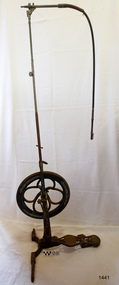 Flagstaff Hill Maritime Museum and Village
Equipment - Dentist Drill, Late 19th century
The design of this and other similar treadle powered dental engine (or dentist drill) was in common use by dentists from the 1870’s into the 1920's. When electricity became accessible to most communities the electrically powered dental engines began to take over from the treadle power. Over the ages teeth were extracted using picks and scissors and other gouging instruments. Bow drills, hand drills and even a "bur thimble" drill were later used to prepare cavities for filling. Some drills were made bendable by attaching flexible shanks between the metal bur and the handle, giving access to the teeth at the back of the mouth. Other mechanical devices were introduced along the way, such as clockwork drills, but they were hard to handle and inefficient. Over the centuries “dentistry has been performed by priests, monks and other healers. This was followed by barbers; the barber’s chair may well have been the precursor to the dental chair. “(SA Medical Heritage Society Inc.) In 1871 James Morrison patented the first commercially manufactured 'foot treadle dental engine', the first practica dental engine although others had been introduced as early as 1790 (by John Greenwood). Handmade steel burs or drills were introduced for dental handpieces, taking advantage of the significant increase in the speed of the drill. In 1891 the first machine-made steel burs were in use. The treadle drill reduced the time to prepare a cavity from hours to less than ten minutes. In 1876 the Samuel S. White Catalogue of Dentist Instruments listed a 12 ½ inch wheel diameter dental engine, with 14 bright steel parts, for sale at US $55 In today’s market, this is the equivalent to US $1200 approx. The specifications of that dental engine are very similar to the this one in our Flagstaff Hill Maritime Village’s collection. It is interesting to note that workings of a similar treadle dentist drill were used and modified to power a treadle spinning wheel of one of the volunteer spinners at Flagstaff Hill Maritime Village. The foot treadle dental engine was a milestone in dental history. “Historic importance of treadle powered machines; they made use of human power in an optimal way” (Lowtech Magazine “Short history of early pedal powered machines”) The invention of a machine to speed up the process of excavation of a tooth lead to the invention of new burs and drills for the handpieces, improving speed and the surgical process of dentistry. They were the fore-runner of today’s electrically powered dental engines. This treadle-powered dentist drill, or dentist engine, is made of iron and steel and provides power for a mechanical dental hand-piece that would be fitted with a dental tool. The drill has a three footed cast iron base, one foot being longer than the other two. A vertical C shaped frame is joined into the centre of the base, holding an axle that has a driving-wheel (or flywheel) and connecting to a crank. A slender, shoulder height post, made from telescoping pipes, joins into the top of this frame and is height adjusted by a hand tightened screw with a round knob. On the post just above the frame is a short metal, horizontal bar (to hold the hand-piece when it is not in use). A narrow tubular arm is attached to the top of the stand at a right angle and can move up and down. At the end of the arm is a firmly fixed, flexible rubber hose protected for a short distance by a sheath of thin metal. At the end of the hose there is a fitting where the drill’s hand-piece would be attached; a small, silver coloured alligator clip is also at the end. A treadle, or foot pedal, is hinged to the heel to the long foot of the base, and joined at the toe to the crank that turns the driving-wheel. There is a spring under the toe of the treadle. The metal driving-wheel has a wide rim. Touching the inside of the rim are four tubular rings that bulge towards the outside of the driving-wheel, away from the pole, and all meet at the hub of the axle. The axle is bulbous between the inside of the driving-wheel and the frame then passes through the frame and is attached on the other side. The driving-wheel has a groove around which a belt would sit. The belt would also fit around a pulley on the arm, at the top of the post. The pulley is joined to a rod inside the arm and this spins the drill's hand-piece and dental tool holder. The two shorter feet of the base are made from a long metal bar that has been curved outwards, and its centre is bolted to the base of the pole. Under the ends of the curved legs of the base are wedge shaped feet. The driving-wheel is decorated in light coloured paint on both sides, each side having three sets of floral decals evenly spaced around them, and each about a sixth of the wheel's circumference. Similar decoration is along the sides of the frame. The foot pedal has decorative cutout patterns in the centre of the foot and at the toe. On the long foot of the stand is some lettering with a fine, light coloured border around it. The lettering is hard to read, being a dark colour and flaking off. There are also remnants of fine, light coloured flourishes. The foot pedal has lettering of the maker’s trade mark cast into the metal at the ball of the foot. Lettering on the base is peeling and difficult to read. The foot pedal has a trade mark cast into it that looks like a combination of ‘C’ , ‘S’ , ‘A’, ‘R’. flagstaff hill, warrnambool, shipwrecked coast, flagstaff hill maritime museum, maritime museum, shipwreck coast, flagstaff hill maritime village, great ocean road, dentist, teeth, dental drill, dental engine, treadle drill, foot powered drill, treadle engine, orthodontics, dental surgery, james morrison -
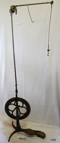 Flagstaff Hill Maritime Museum and Village
Equipment - Dentist Drill, Late 19th century
The design of this and other similar treadle powered dental engine (or dentist drill) was in common use by dentists from the 1870’s into the 1920's. When electricity became accessible to most communities the electrically powered dental engines began to take over from the treadle power. Over the ages teeth were extracted using picks and scissors and other gouging instruments. Bow drills, hand drills and even a "bur thimble" drill were later used to prepare cavities for filling. Some drills were made bendable by attaching flexible shanks between the metal bur and the handle, giving access to the teeth at the back of the mouth. Other mechanical devices were introduced along the way, such as clockwork drills, but they were hard to handle and inefficient. Over the centuries “dentistry has been performed by priests, monks and other healers. This was followed by barbers; the barber’s chair may well have been the precursor to the dental chair. “(SA Medical Heritage Society Inc.) In 1871 James Morrison patented the first commercially manufactured 'foot treadle dental engine', the first practica dental engine although others had been introduced as early as 1790 (by John Greenwood). Handmade steel burs or drills were introduced for dental handpieces, taking advantage of the significant increase in the speed of the drill. In 1891 the first machine-made steel burs were in use. The treadle drill reduced the time to prepare a cavity from hours to less than ten minutes. In 1876 the Samuel S. White Catalogue of Dentist Instruments listed a 12 ½ inch wheel diameter dental engine, with 14 bright steel parts, for sale at US $55 In today’s market, this is the equivalent to US $1200 approx. The specifications of that dental engine are very similar to the this one in our Flagstaff Hill Maritime Village’s collection. It is interesting to note that workings of a similar treadle dentist drill were used and modified to power a treadle spinning wheel of one of the volunteer spinners at Flagstaff Hill Maritime Village. The foot treadle dental engine was a milestone in dental history. “Historic importance of treadle powered machines; they made use of human power in an optimal way” (Lowtech Magazine “Short history of early pedal powered machines”) The invention of a machine to speed up the process of excavation of a tooth lead to the invention of new burs and drills for the handpieces, improving speed and the surgical process of dentistry. They were the fore-runner of today’s electrically powered dental engines. This treadle-powered dentist drill, or dentist engine, is made of iron and steel and provides power for a mechanical dental handpiece that would be fitted with a dental tool. On the foot is painted lettering naming it "The Brentfield" and there is a fine line of light coloured paint creating a border around the name. The paint under the lettering is peeling off. The drill has a Y-shaped, three footed cast iron base, one foot being longer than the other two. A vertical frame is joined into the centre of the base, holding an axle that has a driving-wheel (or flywheel) and connecting to a crank. A slender, shoulder height post, made from adjustable telescoping pipes, joins into the top of this frame. On the post just above the frame is a short metal, horizontal bar (to hold the hand-piece when it is not in use). A narrow tubular arm is attached to the top of the stand at a right angle and can move up, down and around. There is a pulley each side of the joint of the arm and a short way along the arm is fitted a short metal pipe. A little further along the arm a frayed-ended cord hangs down from a hole. At the end of the arm is another pulley and a joint from which hangs a long, thin metal pipe with two pulleys and a fitting on the end. A treadle, or foot pedal, is joined to the long foot of the base, and joined at the toe to the crank that turns the driving-wheel. The metal driving-wheel has a wide rim. Touching the inside of the rim are four tubular rings that bulge towards the outside of the driving-wheel, away from the pole, and all meet at the hub of the axle. The axle fits between the inside of the driving-wheel and the frame then passes through the frame and is attached on the other side. The driving-wheel has a groove around which a belt would sit. The belt would also fit around a pulley on the arm, at the top of the post. The pulley is joined to a rod inside the arm and this spins the drill's hand-piece and dental tool holder. The foot pedal has a cross-hatch pattern on the heel and the ball of the foot has tread lines across it. The end of the toe and the instep areas have cut-out pattern in them. "The ____/ Brentfield / __ DE IN L___" (Made in London) painted on the long foot of the base. Marked on the drill connection is “Richter De Trey, Germany”flagstaff hill, warrnambool, shipwrecked coast, flagstaff hill maritime museum, maritime museum, shipwreck coast, flagstaff hill maritime village, great ocean road, dentist, teeth, dental drill, dental engine, treadle drill, foot powered drill, treadle engine, orthodontics, dental surgery, james morrison, the brentfield, richter de trey, german dental fitting, london dental drill -
 Ringwood and District Historical Society
Photograph, Ringwood State School - Grade 5C, 1961
Black and white photograph"Attached to photograph" Back Row- L to R: Vincent Powell, John Arnett, Christian Kramer, Stephen Lavender, Greg Paine, Stephen Dawe, Charlie Rechnitzer, Rodney Barber, David Webb. 2nd Row- L to R: Kevin McCullough, Andrew Glavimans, Geoff Sjogren, Peter Jenkins, Peter Anderson, John Gadsden, Darryl McDonald, Perry Kaigan, Michael Jackson, Bruce Taylor. 3rd Row- L to R: Mr Delacca, Valerie Robinson, Stephanie Iwanowicz, Robyn Whitchurch, Jimmy Morgan, Jim(Bill) Noble, Sue Lewis, Wendy Long, Rae Moller, Georgina Brooks. Front Row- L to R: Valerie Harrison, Stephanie Tann, Glenda Mayers, Kaye Spencer, Carol Patten, Jeanette Hewlitt, Sandra Thomas, Belinda Clarke, Helen Marr, Robyn Dickson. Teacher: Mr Delacca -
 Ringwood and District Historical Society
Photograph, Ringwood State School- Grade 4B, 1955
Black and white photograph."Attached to photograph" Back Row- L to R: ?, Ken Gowers, Peter Carter, Wally Zielinski, ?, Peter Oliver, ?, Bert Steegstra, Wayne Ennis, ?, ?, Hubert Schroor, John Oliver, Kevin Burden, Arthur Wigley, ?, Thomas Guest. 2nd Row- L to R: Lorraine Guscott, ?, Jeanette Langmead, ?, Lois Caird, ?, Ronda Wilkins, ?, ?, Janis Hudson, Janis Bomford, Barbara Findlay, ?, ?, Chris Harris. 3rd Row- L to R: Richard Burlock, Alan Leviston, Fay Mathews, Dawn Riedel, ?, Ruth Barber, Merlyn Bruce, Erica Burns, ?, Enid Robinson, June robinson, ?, Kathleen Haywood, ?, ?, Barry Jacobs, Sten Bjerking. Front Row- L to R: Rod Clutterbuck, ?, ?, ?, ?, ?, ?, ?, ?. Teacher: -
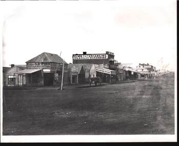 Bendigo Historical Society Inc.
Photograph - W. D. MASON COLLECTION: MUNDY STREET, BENDIGO 1860'S, 1860
Black and white Photograph Mundy Street, Bendigo, 1860s Building signs include .Professor LEWIS'S Haircutting and Shampooing Saloon, Lewis's shaving .Three Barber's poles outside the weatherboard shop. Clothes Cleaning & Renovating, Cahill and Associates- Obstetrician, Empire Restaurant, Dining Rooms & Boarding House, J.Lindop's Family Hotel, Allen Reeve glass, paperhanging, oil & color warehouse, John D.Bywater-Hay & Corn Dealer, Fletchers on the corner, Fosdyke Drapers.Reverse has a rubber stamp - Kilmore Historical Society .The street is unmade and no people appear to be in view -Batchelderphotograph, streetscape, bendigo -
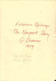 Bendigo Historical Society Inc.
Document - VICTORIAN RAILWAYS - THE NEWPORT STORY
Typed history of the Newport Railway Workshops. Mentions the men who worked at the workshop, the locomotives that were built there, the different classes of locomotives, the equipment they used, and some of the work they did. Written by G. Donneau (who worked there) and dated 19-3-79.document, victorian railways, the newport story, g donneau, melbourne and geelong railway co, melbourne & hobson's bay united railway co, mr william meikle, solomon mirls, richard speight, sir james allport, midland railway, mr allison dalrymple, phoenix foundry, north melbourne loco depot, beyer peacock & co, mr a e smith, roger barnes, thomas tait, bhp, f j shea, commonwealth ordnance department, james rooks, london times, mr merz, mr mclellan, bendigo north railway workshops, ballarat shops, james taylor, donald mcgregor, julius aurelian sylvester barber, victor lethlean, melbourne institute of technology, prince of wales, queen victoria, w m shannon, sir thomas bent, puffing billy, harold winthrop clapp, francis boardman clapp, melbourne tramway & omnibus co, austral otis engineering co, melbourne university, franklin supply co, e h brownbill, heavy harry, locomotive mausoleum north melbourne, north british locomotive co, walter stinton, thomas smith, peter alexander, peter alexander, robert ferguson, king george v, english railway gazette, harry nunn may, merz & maclellan, arthur lowe, r h roach, w h chapman, l c rolls, g a swift, john mcrae, caledonian society, thistle club, bristol hotel, james taylor, george allibon, walter grimshaw, robert maybin, roy hodge, walter biddle, john ramsbottom, robert hewitt, james green, thomas waldhuter, giles dobney, mr richardson, mr arthur, sydney express, the age, mr speight, david syme, father gapon -
 Tatura Irrigation & Wartime Camps Museum
Newspaper clipping, Tatura Guardian, Blast from the Past 1951, 1951
Debutantes with partners. From back left: Kath Mulcahy (Peter Barber), Anne Leslie (Phillip Crawford), Fay Longworth (James McCann), Rhonda Dick (Jack Marshall), Helen Pogue (Bruce Barber), Heather Gurden (Phillip Mactier), Shirley Lovett (Leslie Leaf), Middle : Val Ryan (John Stewart), Theresa Noonan (Donald Stephens), Faye Beddell (Leslie Gavey), Doris De Lai (Ted Gavey), Mary Young (Terry Joyce), Ella Bunn (Neil Morgan), Patrick Dick ). Front: Betty Forbes (Thomas Atley), Madeline Mc Mahon (Neil Thomas), Mrs Pearl Dick (Chaperone), Patricia Pearce (Don Whyte), Edna Hampton (Ian Henderson)Photo of 18 debutantes, with names of their partners in brackets. 1951 -
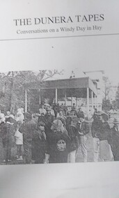 Tatura Irrigation & Wartime Camps Museum
Book, The Dunera Tapes, 1990
Printed on the occasion of the 50th anniversary of the arrival in Australia. Interviews with 69 of the original Dunera men and their families done by 15 Hay students from Hay War Memorial School.Light blue covered folio side bound in black. Contains 70 pages of printed text and photos. Black and white picture on cover. Title in black ink above picture. Black taped spine.The Dunera Tapes Conversations on a Windy Day in Hayhay internment camp, 50th anniversary of dunera arrival, hay war memorial school, internment camp interviews, peter alsberg, paul altmann, max arnott, herbert barber, michael brent, gerald cunningham, peter danziger, reinhold eckfield, peter feistmann, adi felder, henry felder, john fletcher, werner frank, fred freitag, ernest green, john gresham, dennis goodman, frank heymann, horst jacobs, ernie katz, walter kaufmann, jimmy king, heinz kuehlenthal, george lederer, kurt leiser, kurt lewinski, hans loewe, franz menzel, rudi meth, albert meyer, martin moore, fred parkinson, fred reich, howard rickenberg, ernest rodeck, max rubinsohn, fren schonbach, ernest schonfeld, henry seaman, martin shelton, mike sondheim, ralph stern, george strauss, henry teltscher, roy thalheimer, herbert treidel, harry unger, fred warschauer, harold weinberg, mendel weisser, victor wieselmann, walter weyl, ernst wolf, christoph wolkenstein, oswald wolkenstein -
Stawell Historical Society Inc
Photograph, Mick Walsh, Mick Walsh Stawell Studio Colour Negatives, 1975 to 1986
Negatives from Stawell Photographer. Discarded from Penna Print Ararat. Son contacted and gave approval for Stawell Historical Society to keep them. Only those of a non personal nature scanned. Parish family Dalgetty Sheep Train Jean Holmes Family Kath Banfield & Col Petch Ridd Family Joel Fire Brigade Joel Joel Girls Fire Brigade Ryan Grandchildren Walter Boothey Shalder Grandchildren Hodgetts Silver Wedding Geoff Robertson Family Prue Spittle & Bill Moorshead Elaine Feldman & Maurie Stewart Pamela Barber & Howard Cooper Helen David & Scott Grainger Barry Henderson baby Pickford Baby, Donna Smith & Wayne Reddrop Val Morris & John Kennedy SFC Coaches 1978 Mr & Mrs Robyn Smith halls gap Rosemary Spriggs & Robin Smith Walker Family Bill Dunmore Baby Mr & Mrs C Woodman Greg Holmes Baby Bartholomew & Coughlan Colour negatives of families, weddings and other. Nineteen Lever Arch Folders Mick Walsh 52 Patrick Street Stawellphotography -
 Mt Dandenong & District Historical Society Inc.
Photograph, Home of George and Sarah Barber c1905
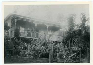
George and Sarah Ann Barbers home "Forest Edge' on Barber's Road. Jabez Richardson (father of Sarah Ann) and his wife Sarah jane are standing on the front verandah. An unknown male is also in the picture.Black and white photograph showing four adults standing on the front verandah of a house. Reverse of photograph has handwritten description by John Lundy-Clarke.Jabez and Sarah Jane Richardson on verandah of home of their daughter Sarah Ann (Mrs Barber) 1905. Sarah jane died 1906. Jabez died 1908.forest edge, george barber, sarah ann richardson, sarah ann barber, jabez richardson, sarah jane richardson -
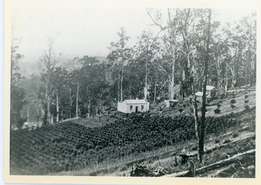
 Mt Dandenong & District Historical Society Inc.
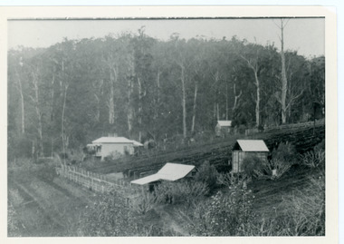
Photograph, George Barber's Home Forest Edge after 1912 Looking South West, c1912
... handwritten description by John Lundy-Clarke. George Barber's Home ...George Barber built a homestead later named Forest Edge on Barber's Road and lived there with his wife Sarah Ann (nee Richardson).Black and white photograph showing the side view of a house and three outbuildings. Reverse of photograph has handwritten description by John Lundy-Clarke.George Barber's home on bend of Barber's Road on Lot 25, Village Settlement. Showing passionfruit plantation. Buggy shed top right. Hay shed lower right. Stables, cart shed and men's quarters lower left about 1912. Photo copied by JLC in 1973.forest edge, george barber, sarah ann barber, kalorama, barber's road -
 Mt Dandenong & District Historical Society Inc.
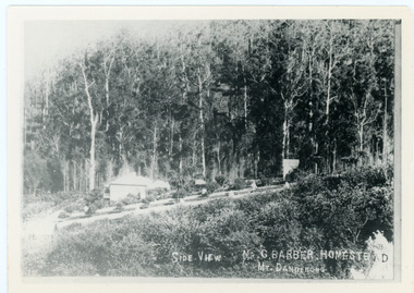
Photograph, Side View Mr G. Barber Homestead Mt Dandenong, c1905
Built in 1898 by early settler George Barber the property is still in existence today. It was the home of George, wife Sarah Ann and daughter Ethel.Black and white photograph showing te side view of George Barber's home, later named Forest Edge. c1905. Reverse of photograph has handwritten description by John Lundy-Clarke.Barber's home on Olinda Creek. Lot 25 Sect 1 Village Settlement. Home of George Barber and wife Sarah Ann (nee Richardson). Daughter Ethel.Was bought by Munnerley later Sangster and Kinnear. Later known as Forest Edge. Buggy and wagon shed on right. Photo copied 1973 by JLC. -
 Mt Dandenong & District Historical Society Inc.
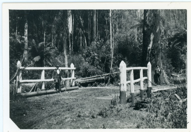
Photograph, Barber's Bridge on Olinda Creek
John Lundy-Clarke grew up in the Kalorama/Mt Dandenong area and later in life (1972-74) began to write a comprehensive history of the area working from an original settlement map in an effort to cover all areas. Barbers Bridge was named after George Barber, an early settler.Black and white photograph showing a man standing on a bridge over the Olinda Creek. 1910Handwritten n reverse: Barbers Bridge on Olinda Creek 1910. This was a ford crossed by the road after Isaac Jeeves selected allotment “C” “Jeeves Saddle” in 1871 and stopped travel through his property. The bridge has been built several times but at time of writing (1974) is replaced by a culvert consisting of two pipes two feet six inches wide. They are quite incapable of carrying the maximum flow of the creek and will be swept away.lundy-clarke, barber, barbers bridge, isaac jeeves, jeeves saddle, bridge, olinda creek -
 Mt Dandenong & District Historical Society Inc.
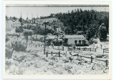
Photograph, View Up Valley At Kalorama
... Kalorama Valley John Lundy-Clarke Barbers Road George Barber Kia ...John Lundy-Clarke grew up in the Kalorama/Mt Dandenong area and later in life (1972-74) began to write a comprehensive history of the area working from an original settlement map in an effort to cover all areas. The building in the centre of the photograph is 'Kia-Ora' guest house. Situated on Barber’s Road, ‘Kia-Ora’ was built in 1912 by George Barber. It was later leased by a Mrs Pemberthy. “Kia-Ora’ was one of four places connected when the telephone was brought into the district in 1912. The other places were ‘Mountjoy’, ‘Cherry Farm’ and ‘Callum House’. ‘Kia-Ora’ was burnt down in 1924. Black and White copy of section of a Rose Series postcard. Shows view up the valley at Kalorama with a decorative building centre middle of photograph. Handwritten description by John Lundy-Clarke on reverse.View up valley at Kalorama from near junction of Barbers and Doughty’s Rds. “Kia Ora” guest house in centre. Paynter’s “Iona” top left with “Kalorama” to its right. About 1912. Rose Series copied by JLC 1973.kalorama, kalorama valley, john lundy-clarke, barbers road, george barber, kia-ora, guest house, iona -
 Mt Dandenong & District Historical Society Inc.
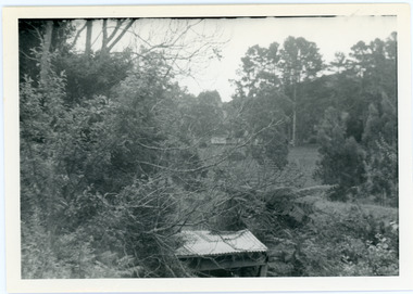
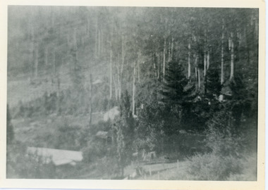
Photograph, View from George Barber's Home To His Stables
... sine 1905. barbers road john lundy-clarke kalorama View from ...John Lundy-Clarke grew up in the Kalorama/Mt Dandenong area and later in life (1972-74) began to write a comprehensive history of the area working from an original settlement map in an effort to cover all areas. This photograph was taken by John Lundy-Clarke in 1973 to show changes to the environment sine 1905.Black and white photograph with tangled bush and small shed in foreground looking towards a cleared area. Handwritten description on reverse written by John Lundy-ClarkeView from Barbers drive to his stables close to where 1905 picture was taken. Stables in foreground. Looking towards Gap. Taken JLC November 1973.barbers road, john lundy-clarke, kalorama -
 Mt Dandenong & District Historical Society Inc.
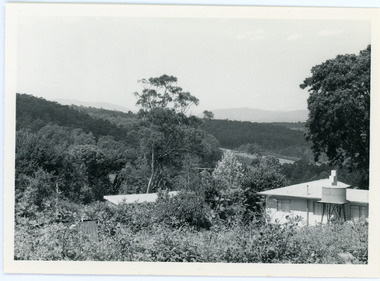
Photograph, View From Ernest Road To Site Of "Kia-Ora"
John Lundy-Clarke grew up in the Kalorama/Mt Dandenong area and later in life (1972-74) began to write a comprehensive history of the area working from an original settlement map in an effort to cover all areas. The photograph taken c1973 from Ernest Road looks over the site of the Kia-Ora guesthouse which is marked by the oalm tree that can be seen at the front of the flat roof close to the gum tree trunk. Situated on Barber’s Road, ‘Kia-Ora’ was built in 1912 by George Barber. It was later leased by a Mrs Pemberthy. “Kia-Ora’ was one of four places connected when the telephone was brought into the district in 1912. The other places were ‘Mountjoy’, ‘Cherry Farm’ and ‘Callum House’. ‘Kia-Ora’ was burnt down in 1924.Black and white photograph showing a house with water tank in right foreground and another flat roof centre foreground. There is a handwritten description by John Lundy-Clarke on the reverse.View 1973 from corner of Ernest Rd and Outlook Drive Lot 24 Village Settlement looking over the site of “Kia Ora” to the pioneers clearings. The palm tree seen above the flat roof (Rex) on left, is on the exact site of “Kia Ora”. Photo JLCernest road, john lundy-clarke, kia=ors, guest house, guesthouse -
 Mt Dandenong & District Historical Society Inc.
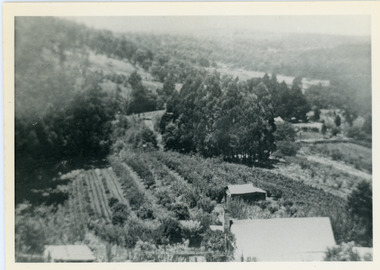
Photograph, View Over Logan's From Barber's Road
Robert Logan selected Lot 28 of the Village Settlement in 1896 and lived there until his death in 1936. Historian John Lundy-Clarke tells how Logan planted his land with plums, peaches and apples and also grew raspberries, beans, cabbages and lettuces. He also planted a small patch of oats that he harvested to feed his horse. This photograph was taken c1920 and shows the view over Logan's property of Harmony Vale, taken from Barber's Road.Black and white photograph showing lines of crops and orchard trees with rooftops in foreground and larger trees and cleared areas in background.robert logan, logan, orchard, crops, raspberries, harmony vale, barbers road -
 Mt Dandenong & District Historical Society Inc.
Photograph, View Over Roof of "Kalorama"
Taken in 1908, this photograph, though rather blurry, gives an indication of the location of the early settler properties in the valley in relation to one another. European trees have been planted at 'Kalorama' , the first home of Ellis Jeeves. John Lundy-Clarke grew up in the Kalorama/Mt Dandenong area and later in life (1972-74) began to write a comprehensive history of the area working from an original settlement map in an effort to cover all areas.Black and white photograph looking across hillside with large trees and rooftops visible. Handwritten description on reverse by John Lundy-Clarke.1908 View over roof of “Kalorama” towards the Falls. Paynter’s house on LOT 29 in low centre (now “Yosemite”). Pimms house on LOT 19 above Paynters and beyond scrub. Logan’s house faint above left of “Kalorama”. Dunbar’s LOT 20 beyond Pimm’s orchard. Gum trees on right were on Price’s LOT 19 now Tosari Rd area. It was one of these that figured in the episode of the runaway log in 1930. It leaped in one bound over Barbers Road at bottom of scrub in centre of picture then over Logan’s house.kalorama, ellis jeeves, jeeves -
 Mt Dandenong & District Historical Society Inc.
Photograph, Walker's LOT 2
Lot 2 was bought by Harry Walker in the early 1900s. Harry was married to Eva Hand, one of the six daughters of Thomas and Eliza Hand. Harry cleared the land and planted half with raspberries that remained productive until c1928. Harry's son William took over the property. The land was cut in half when the new CRB road went through in the early 1920s. John Lundy-Clarke grew up in the Kalorama/Mt Dandenong area and later in life (1972-74) began to write a comprehensive history of the area working from an original settlement map in an effort to cover all areas.Black and white photograph showing a single storey white house in the centre surrounded by crops. Handwritten description on reverse by John Lundy-Clarke.VIEW 1908 OVER LOT 2 SECTION 1 VILLAGE SETTLEMENT. TAKEN FROM RIDGE ROAD THEN MAIN ROAD FROM HALFWAY BETWEEN MOUNTJOY AND FALLS RD. CRB MAIN RD RUNS BEHIND WALKER’S HOUSE. The house seen in the vista among the tall trees beyond the raspberry patch is “Forest Edge” which was George Barber’s home when the picture was taken. The tall trees to the right of the vista were on Price’s LOT 18 and it was while cutting up one of these for firewood that a length of log weighing about ½ a ton got away downhill and leaped in one bounce over Barbers Road and Logan’s house – 1931.harry walker, william walker, eva hand, crb road, raspberries, kalorama -
 Mt Dandenong & District Historical Society Inc.
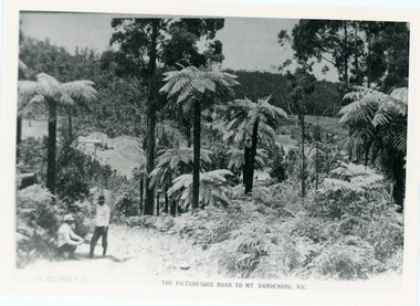
Photograph, View From Doughty's Road 1913
Mt Calvin, the homestead of Jeanie and Willie Richardson can be clearly seen in the clearing above the men in the picture. The white roof of the Barber homestead is on the right of the picture. A landslide in 1934 destroyed the tree ferned area. John Lundy-Clarke grew up in the Kalorama/Mt Dandenong area and later in life (1972-74) began to write a comprehensive history of the area working from an original settlement map in an effort to cover all areas.Black and white photograph that is a copy of a Rose series postcard titled 'The Picturesque Road to Mt. Dandenong. Vic.' It shows two men (probably Rose Series employees), one sitting and one standing at the edge of an unmade road. Large tree ferns line the roadside. Handwritten inscription on reverse by John Lundy-Clarke1913 View east from Doughty’s Road showing Jeannie Richardson’s home through the gap in the trees. A little to the right of and below centre of picture can be seen George Barber’s home with Barbers Road turning around the wagon shed that was a little up the hill from the house. The tree ferns in the picture were destroyed in the landslide of 1934. In the distance at the right can be seen F.M. Childs Homestead complex with the Richardson paddocks beyond it.mt calvin, jeanie richardson, willie richardson, george barber, landslide, tree fern -
 Mt Dandenong & District Historical Society Inc.
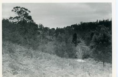
Photograph, View Up Valley Towards Kalorama Gap 1973
John Lundy-Clarke grew up in the Kalorama/Mt Dandenong area and later in life (1972-74) began to write a comprehensive history of the area working from an original settlement map in an effort to cover all areas. This photograph would have been taken to show the changes in the area over the years. Kalorama Gap is now called Five Ways. 'Kia-Ora ' was a guest house built by George Barber. It is no longer standing.Black and white photograph showing a bush scene with a white car visible on the right. Handwritten inscription on reverse by John Lundy-Clarke1973 View up Valley towards Kalorama Gap from what was Crooks LOT 24. White car is on Barbers Road and site of “Kia Ora” is to right of it.kalorama, kalorama gap, five ways, barbers road, george barber, kia-ora