Showing 67 items matching "kingston district"
-
 City of Kingston
Photograph - Black and white, 20 December 1945
Cheltenham is a suburb in the City of Kingston that was originally established as a rural market gardening community. The area is bordered by Highett, Mentone and Heatherton. The market gardens, farms and paddocks have gradually been sub-divided into housing and industrial estates. The Southland shopping centre is a major feature of the area.Cheltenham was established as a rural market gardening community. The Le Page family lived in Cheltenham since 1854 when Nicholas Le Page, a tailor from the Channel Island of Guernsey, bought two acres of land on Chesterville Road near Bernard Street to establish a market garden. Over the years the Le Pages purchased more land in the area. In 1875-76 Nicholas' son Frank and his wife Mary built 'Daphne Cottage' near the corner of Bernard and Wilson Streets. n the 1940s Frank's son, Everest Le Page, bought five more lots of land in Chesterville Road from the Tuck family. The Le Pages grazed horses, ponies and cows on this land, and grew pumpkins, carrots, parsnips, onions, potatoes and cabbages. Many buildings and locations within in Cheltenham commemorate the Le Page family's contribution to the Cheltenham community.Aerial photograph taken in 1945 of the Cheltenham district within the City of Kingston. The image includes Chesterville Road, the future site of Turner Road pool (now Waves) and Highett Reserve, (top left), Jellicoe Street, Argus Street, Bernard Street, Wilson Street, the Methodist Children Homes (now Southland), McIvor Street, Goulburn Street, Nepean Highway, Jamieson Street and Barker Street (bottom left), market gardens and paddocks. In the top centre of the image, "Daphne Cottage", the home of Frank T. Le Page is visible on the corner of Bernard and Wilson Streets. Much of the land depicted in this image was owned by the Le Page family. This image is possibly from the collection of aerial photographs commissioned by the Department of Crown Lands and Survey and taken by Adastra Airways.Black and white ink: 57250 White print: VIC-170 57250 20.12.45 Run 6 PROJ. No. 5 MELB. METROP AREA Black type 10200 FTS 30' LENS 20.12.45cheltenham, market gardens, industry, le page family -
 City of Kingston
Photograph - Black and white, 5 January 1984
Cheltenham and Heatherton are suburbs in the City of Kingston that were originally established as a rural market gardening community. The market gardens, farms and paddocks have gradually been sub-divided into housing and industrial estates and associated infrastructure such as schools and shopping facilities. This aerial image covers a diverse section of the City of Kingston, taking in the suburbs of Cheltenham, Heatherton, Mentone and Parkdale. By 1984, the market gardens of the district have been replaced by housing and factories. The Nylex factory is visible and now closed. Mentone Bowl on the corner of Warrigal Road and Nepean Highway has now been replaced by high rise apartments, another feature of the changing landscape in the City of Kingston. The vacant land now occupied by the Moorabbin Airport Direct factory Outlet (DFO) is also depicted.Aerial photograph of Cheltenham, Heatherton, Mentone and Parkdale within the City of Kingston. The area depicted in the 1984 aerial view includes Centre Dandenong Road and Cheltenham East Primary School (top left), Kingston Heath Reserve (top right), intersection of Lower Dandenong Road, Warrigal Road, Balcombe Road and Nepean Highway (bottom left), Balmoral Drive/McSwain Street Parkdale (bottom right).White text: 3831-179 Lens information [indecipherable] RINGWOOD M/S 7922-3 RUN 16 [Clockface image] 5,300' ASL VIC DLS© 5-1-84cheltenham, heatherton, mentone, parkdale, market gardens, urbanisation -
City of Kingston
Photograph - Black and white, 5 January 1984
Moorabbin, Cheltenham and Highett are suburbs in the City of Kingston with a diverse mix of development and zoning. The market gardens, farms and paddocks have gradually been sub-divided into housing and industrial estates and associated infrastructure such as schools and shopping facilities. The area includes many parks, reserves and golf courses.This aerial image covers a diverse section of the City of Kingston, taking in the suburbs of Cheltenham, Moorabbin, Beaumaris and Highett. By 1984, the market gardens of the district have been replaced by housing and factories. The Gas and Fuel state-of-the-art Scientific Services Department is visible on Nepean Highway Highett. The CSIRO Highett site can also be seen. Both sites have now been demolished and have undergone remediation. The Southland site is visible and yet to be redeveloped by Westfield. This image portrays the diversity of development in the City of Kingston with a mixture of green spaces, housing and commercial and industrial features.Aerial photograph of Cheltenham, Beaumaris, Moorabbin and Highett within the City of Kingston. The area depicted in the 1984 aerial view includes Eden Street and Edward Street, Cheltenham (top left), Weatherall Road and Reserve Road, Cheltenham/Beaumaris (top right), Turner Road and Chesterville Road, Moorabbin (bottom left), Nepean Highway (left section), Graham Road and Middleton Street, Highett (bottom right). A large section of this image includes Cheltenham Park and Victoria Golf Club.White text: 3831-219 Lens information [indecipherable] RINGWOOD M/S 7922-3 RUN 15 Clockface image 5,300' ASL VIC DLS© 5-1-84cheltenham, highett, industrialisation, urbanisation, moorabbin, beaumaris -
City of Kingston
Photograph - Black and white, 17 January 1951
Moorabbin, Cheltenham and Highett are suburbs in the City of Kingston with a diverse mix of development and zoning. This 1954 image shows the market gardens, farms and paddocks of the Moorabbin and Cheltenham area. which have gradually been sub-divided into The Highett Gas Works is visible and Cheltenham Park and Victoria Golf Club.The suburbs of Cheltenham and Moorabbin were originally developed with extensive market gardens. Over time the district has been transformed with the farms and paddocks replaced by housing, factories and shopping centres. The Highett Gas Works on the Nepean Highway was a significant feature of the landscape and has now been demolished. and the site has undergone remediation.Aerial photograph of Cheltenham, Moorabbin and Highett within the City of Kingston. The area depicted in this 1951 aerial view includes Wickham Road, Highett (bottom right), Keys Road, Moorabbin (bottom left), Centre Dandenong Road Cheltenham (top left), Park Road, Cheltenham (top right), Nepean Highway (left section), Graham Road and Middleton Street, Highett (bottom right). Cheltenham Park and Victoria Golf Club are visible. Nepean Highway and the Frankston railway line run centrally through the image.White type: 1416-37 538 RUN239 LENS 5312" MELBOURNE METROPOLITAN 12150 17-1-51 ↆ M539 Black pencil: N [arrow]cheltenham, highett, highett gas works, market gardens -
City of Kingston
Photograph - Black and white, 27 February 1964
Cheltenham is a suburb in the City of Kingston that was originally established as a rural market gardening community. The area is bordered by Highett. The previous market gardens, farms and paddocks have gradually been sub-divided into housing and industrial estates. The Methodist Children's Home Methodist Homes for Children and St John of God Training Centre on the site of the future Southland shopping centre has not yet been demolished. The recently built Cheltenham High School is visible and the increased urbansation of the area is evident. Some farmland remains including the Le Page homestead.The developing urban area of Cheltenham within the City of Kingston. This image illustrates the mid-century urban sprawl of of Cheltenham and the subdivision of market gardens within the municipality and the changing demographic of the district as new houses are constructed and infrastructure established.Aerial photograph of the suburbs of Cheltenham and Highett within the City of Kingston. Highett Gas Works (top left); Bernard Street, Cheltenham (top right); Weatherall Road (bottom left): Elliott and Cobham Streets Cheltenham (bottom right).White handwritten: X Vic.1831 White type: MELBOURNE 1963 PROJECT RUN23 [underlined] 27-2-64 LENS 205 152-70 M/M 5.150 [arrow] White handwritten: X 166 cheltenham, highett, urbanisation -
 City of Kingston
Pamphlet - Black and white, Robert McCamish & John Gilpin (Vendors), For Private Sale Station Entrance Estate, Highett, 1930s
Sales plan for land in the suburb of Highett, bounded by Wickham Road, Railway Parade, Highett Road and Point Nepean Street. The developing urban area of Highett within the City of Kingston. This land sale pamphlet illustrates the subdivision of land within the municipality and the changing demographic of the district as new houses are constructed. The extension of the railway line from the city to Mordialloc opened up the land for development.Black and white pamphlet advertising for private sale the Station Entrance Estate, Highett. Incorporates a map of the estate bordered by Wickham Road, Railway Parade, Highett Road and Point Nepean Road. Handwritten in black ink on reverse: Station Entrance / Estate / Late [indecipherable]highett, land sales, estate -
 City of Kingston
Pamphlet - Colour, Stillwell and Co, The Hill Estate Highett Great Subdivisional Auction Sale, 1917
Sales plan for land in the suburb of Highett, bounded by Point Nepean Road and incorporating Sandford Street, Turner Road, Alfred Street, Peace Street and Tennyson Street. .The developing urban area of Highett within the City of Kingston. This land sale pamphlet illustrates the subdivision of land within the municipality and the changing demographic of the district as new houses are constructed.Colour pamphlet advertising subdivisional auction sale of the Hill Estate Highett. Incorporates a map of the estate bordered by Point Nepean Road and encompassing Sandford Street, Turner Road, Alfred Street, Peace Street and Tennyson St. Handwritten in grey pencil on reverse: Hill Street / Jamieson Handwritten in blue pencil on reverse: The Hill Estate Handwritten in blue pencil on subdivision map: [tick] [on majority of properties marked on map]highett, land sales, estate -
 City of Kingston
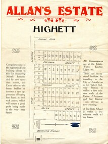
Pamphlet - Colour, Allan's Estate Highett, 1930s
Sales plan for land in the suburb of Highett, bounded by Spring Road, Highett Road and Worthing Terrace.The developing urban area of Highett within the City of Kingston. This land sale pamphlet illustrates the subdivision of land within the municipality and the changing demographic of the district as new houses are constructed.Colour pamphlet advertising Allan's Estate, Highett. Incorporates a map of the estate bordered by Spring Road, Highett Road and Worthing Terrace.Handwritten in grey pencil on reverse: Allan's Estate / Highett Crossed out in blue pencil on front: Name and address of what appears to be a solicitorhighett, land sales, estate -
 City of Kingston
Pamphlet - Colour, W. H. Wood Estate Agent, Subdivisional Land Auction Barker's Estate Cheltenham, 1919
Sales plan for land in the suburb of Cheltenham, along Barker StreetThe developing urban area of Cheltenham within the City of Kingston. This land sale pamphlet illustrates the subdivision of land within the municipality and the changing demographic of the district as new houses are constructed.Colour pamphlet advertising subdivisional land auction of Barker's estate, on Barker Street Cheltenham.Handwritten in grey pencil on the subdivision map: a series of numbers on each block possibly indicating the sale price. Handwritten in grey pencil on the subdivision map: Roy- joined to subdivision 6 Handwritten in grey pencil on the subdivision map: x on the border between subdivision 17 and 16, and again on the border between subdivision 12 and 11.cheltenham, land sales, estate -
 City of Kingston
Pamphlet - Black and white, Stott & Burke, Highland Estate Bentleigh, c.1915
Sales plan for land in the suburb of Bentleigh, along Collins and Ross Streets, bounded by Jasper Road.The developing urban area of Bentleigh within the City of Kingston. This land sale pamphlet illustrates the subdivision of land within the municipality and the changing demographic of the district as new houses are constructed.Black and white pamphlet advertising for private sale the Highland Estate, Bentleigh. Incorporates a map of the estate between Collins St and Ross St, bordered by Japser Road. Handwritten in grey pencil on map: additional subdivisions numbered 15-19 drawn along Ross St Handwritten in grey pencil on map: indecipherable annotations to subdivisions 1, 3 and 14land sales, bentleigh, estate -
 City of Kingston
Pamphlet - Colour, Ozone Hill Estate, Cheltenham, 1923
Sales plan for land in the suburb of Cheltenham, along both sides of Victori Avenue, off Weatherall Road.The developing urban area of Cheltenham within the City of Kingston. This land sale pamphlet illustrates the subdivision of land within the municipality and the changing demographic of the district as new houses are constructed.Colour pamphlet advertising for sale the Ozone Hill Estate, Cheltenham. Incorporates a map of the estate on either side of Victor Avenue, off Weatherall Road. Handwritten in blue ink on the subdivision map: 'Sold' is written on subdivisions 1-4, 8, 11, 13, 16-26, 28, 29, 33, 39-41 Handwritten in blue ink on the subdivision map: 'House being erected' is written on subdivisions 22 and 33. Handwrittten in grey pencil adjacent to subdivisions 21 and 22: Tennis / Courts / being / constructed / here Handwritten in grey pencil at bottom of page: Revised to 30/1/24 Handwritten in grey pencil on subdivision map: assumed land sale price is recorded on subdivisions 5-9, 9-10, 12, 14-15, 27, 30-32, 34-38. land sales, cheltenham, estate -
 City of Kingston
Pamphlet - Colour, H. R. Hill & Co, Walker's Estate, Cheltenham for sale by public auction, c. 1923
Sales plan for land in the suburb of Cheltenham, encompassing both sides of Walker Grove, a section of Centre Dandenong Rd and Axelton St. The developing urban area of Cheltenham within the City of Kingston. This land sale pamphlet illustrates the subdivision of land within the municipality and the changing demographic of the district as new houses are constructed.Black and white pamphlet advertising for private sale the Station Entrance Estate, Highett. Incorporates a map of the estate bordered by Wickham Road, Railway Parade, Highett Road and Point Nepean Road.Handwritten in black pen on subdivision map: 'x' written on subdivisions 2, 3, 8-11, 15-17, 19. Potentially indicating that these properties did not sell at auction. Handwritten in black pen on subdivision map: assumed sale price on subdivisions 1, 4-7, 12-14, 18, 20-31. land sales, cheltenham, estate -
 City of Kingston
Pamphlet - Colour, Stillwell and Co, Cheltenham Charman Estate Realising Auction, 1921
Sales plan for land in the suburb of Cheltenham, along Charman Road and Weatherall Street.The developing urban area of Cheltenham within the City of Kingston. This land sale pamphlet illustrates the subdivision of land within the municipality and the changing demographic of the district as new houses are constructed.Colour pamphlet advertising realising auction of the Charman Estate, Cheltenham. Incorporates a map of the estate, showing subdivisions along Charman Road and Weatherall Street.land sales, cheltenham, estate -
 City of Kingston
Pamphlet - Colour, Duffus Bros, Railway Reserve Highett, c. 1923
Sales plan for land in the suburb of Highett, titled Railway Reserve, incorporating properties along Wolseley Street, Livingston Street, Highett Road and Worthing Road. The developing urban area of Highett within the City of Kingston. This land sale pamphlet illustrates the subdivision of land within the municipality and the changing demographic of the district as new houses and shops are constructed close to infrastructure.Colour pamphlet advertising thirty eight shop and villa sites for sale at the Railway Reserve, Highett. Incorporates a map of the reserve with properties available on Wolseley Street, Livingston Street, Highett Road and Worthing Road. Handwritten in grey pencil: assumed sale price recorded on subdivisions 1-7, 10, 22, 23 and 34 Handwritten in grey pencil on subdivision 4: C. Nevill / City of Melbourne bank Handwritten in grey pencil across subdivision 7: 49' Handwritten in grey pencil across subdivision 21 and 22: 134' Handwritten in grey pencil across subdivision 25 and 26: 200' Handwritten in grey pencil across subdivision 36 and 37 and both top and bottom: 120' Hand drawn in blue pencil: outline of subdivision 4 Hand drawn in blue pencil: outline of subdivisions 7, 23, 28, 37, 38 along left hand side, subdivisions 38, 37 and 36 on Wolseley Street, subdivisions 30 and 29 along Wolseley Street, subdivisions 29 and 24 along the middle of the plan, subdivisions 24 and half of 25 along Livingston Street, half of subdivision 20 along the middle of the plan, subdivisions 21 and 22 along the Right of Way between Livingston Street and Highett Road, and along the right hand border of subdivision 7. Handwritten in ink adjacent to the subdivision plan, updside down, in the bottom right hand corner: 276 / 54 / 280 / 45 / 320 / 202 / 200 / 134 / horizontal line / 11/14 Handwritten in ink adjacent to the subdivision plan, updside down, in the bottom right hand corner: 1714)2200(15 / 1714 / horizontal line / 486land sales, highett -
 City of Kingston
Pamphlet - Colour, Roy Dunn Pty. Ltd, Central Corner Estate Moorabbin and Highett, c. 1923
Sales plan for land in the suburbs of Highett and Moorabbin, bordered by Point Nepean Road and Wickham Road East incorporating William StreetThe developing urban area of Highett and Moorabbin within the City of Kingston. This land sale pamphlet illustrates the subdivision of land within the municipality and the changing demographic of the district as new houses are constructed close to infrastructure.Colour pamphlet advertising for private sale land in the Central Corner Estate in Moorabbin and Highett. Incorporates a map of the estate bordered by Point Nepean Road and Wickham Road East, with subdivisions also available on both sides of William Street. Handwritten in blue pencil on subdivision plan: a tick is drawn on subdivisions 2-18 Handwritten in blue pencil on subdivision 6: a box with an x inside Handwritten in blue pencil on subdivisions 10 and 12: S Handwritten in black ink on front page: [indecipherable] / McKittricks Handwritten in grey pencil on rear page: McKilhick / Nepean Rd Handwritten in grey pencil on rear page upside down: 160000 / 15 8300 [crossed out] land sales, estate, highett, moorabbin -
 City of Kingston
Pamphlet - Colour, Roy Dunn Pty. Ltd, Subdivisional auction of Highett Station Estate, c.1924
Sales plan for land in the suburb of Highett, bounded by Worthing Road, and the Melbourne to Frankston Electric Railway Line, including LePage Street. The developing urban area of Highett within the City of Kingston. This land sale pamphlet illustrates the subdivision of land within the municipality and the changing demographic of the district as new houses are constructed close to infrastructure.Colour pamphlet advertising a subdivisional auction of the Highett Station Estate. Incorporates a map of the estate bordered by Worthing Road and the Melbourne to Frankston Electric Railway, and including LePage Street. Handwritten in black ink on front cover: Late LePage / Wickham Rdland sales, estate, highett -
 City of Kingston
Pamphlet - Colour, W. H. Wood Estate Agent, Realising sub-divisional auction sale Bentleigh Park Estate, Bentleigh, 1920
Sales plan for land in the suburb of Bentleigh, bounded by Centre Road, and incorporating subdivisions on either side of Elizabeth Street (Wheatley Road), Oak Street and Beech Street.The developing urban area of Bentleigh within the City of Kingston. This land sale pamphlet illustrates the subdivision of land within the municipality and the changing demographic of the district as new houses are constructed close to infrastructure.Colour pamphlet advertising a realising sub-divisional auction sale of the Bentleigh Park Estate, Bentleigh. Incorporates a map of the estate bordered by Centre Road, and including Elizabeth Street (Wheatley Road), Oak Street and Beech Street.Hand drawn in grey pencil: a small square on subdivision 33 Hand drawn in grey pencil: a small square incorporating a cross on subdivision 24 Hand written in black ink on reverse: Bentleigh Park / Estate / Ward late Andersonsland sales, estate, bentleigh -
 City of Kingston
Pamphlet - Colour, T. H. Ould Publishing Co, The Ridge Estate, Cheltenham, c. 1930
Sales plan for land in the suburb of Cheltenham, bounded by Johnston Street, Silver Street and Cavanagh Street, incorporating lots on either side of Sunray Avenue.The developing urban area of Cheltenham within the City of Kingston. This land sale pamphlet illustrates the subdivision of land within the municipality and the changing demographic of the district as new houses are constructed close to infrastructure.Colour pamphlet advertising for sale lots in The Ridge Entrance Estate, Cheltenham. Incorporates a map of the estate bordered by Johnston Street, Silver Street and Cavanagh Street, including subdivision lots on either side of Sunray Avenueland sales, estate, cheltenham -
 City of Kingston
Pamphlet - Colour, S. M. Reynolds, Estate Agent, Moorabbin Shire Hall Estate Second Section, c. 1930
Sales plan for land in the suburb of Moorabbin, bounded by South Road and Highbury Street, including Prince Street, Charming Street, Thomas Avenue and Keith Road.The developing urban area of Moorabbin within the City of Kingston. This land sale pamphlet illustrates the subdivision of land within the municipality and the changing demographic of the district as new houses are constructed close to infrastructure.Colour pamphlet advertising for private sale the Moorabbin Shire Hall Estate, Moorabbin. Incorporates a map of the estate bordered by South Road and Highbury Street, including Prince Street, Charming Street, Keith Road and Thomas Avenue.Handwritten in grey pencil on subdivision map below subdivision 63: £4 Handwritten in grey pencil on subdivision map below subdivision 66: 4 Handwritten in grey pencil on subdivision map below subdivision 80: 3. Handwritten in grey pencil on subdivision map below subdivision 81: 4 Handwritten in grey pencil on subdivision map below subdivision 83: 2 Handwritten in grey pencil on subdivision map below subdivision 96: £3 Handwritten in grey pencil on subdivision map below subdivision 97: 3 Handwritten in grey pencil on subdivision map to the left of subdivision 102: 3 Handwritten in grey pencil on subdivision map on the corner of Thomas Avenue and Highbury Street: vertical line next to a square with a cross in it.land sales, estate, moorabbin -
 City of Kingston
Pamphlet - Colour, Fergusson & Mitchell Lith, Sandringham Rises, c. 1888
Sales plan for land in the suburb of Sandringham, bounded by Bluff Road, Bay Road and William Street, and incorporating Frances Street.The developing urban area of Highett (then called Sandringham) within the City of Kingston. This land sale pamphlet illustrates the subdivision of land within the municipality and the changing demographic of the district as new houses are constructed close to infrastructure.Colour pamphlet advertising for sale 35 lots in Sandringham Rises, Sandringham. Incorporates a map of the estate bordered by Bluff Road, Bay Road and William Street, including Frances Street.Handwritten in grey pencil next to the words 'THREE O'CLOCK': 1888 Handwritten in blue ben next to the words '& BUSINESS SITES': 1888land sales, sandringham, highett -
 City of Kingston
Pamphlet - Colour, Brock Bros, South Brighton Township Estate, 1888
Sales plan for land in the suburb of South Brighton (Moorabbin), bounded by Point Nepean Road, South Road, Patterson Street and the Mordialloc Railway Line. Incorporates Wolsely Street and Gordon StreetThe developing urban area of Moorabbin within the City of Kingston. This land sale pamphlet illustrates the subdivision of land within the municipality and the changing demographic of the district as new houses are constructed close to infrastructure.Colour pamphlet advertising for private sale the South Brighton Township Estate, South Brighton. Incorporates a map of the estate bordered by Point Nepean Road, South Road, Patterson Street, and the Mordialloc Railway Line. Includes Wolsley Street and Gordon Street. land sales, south brighton, estate, moorabbin -
 City of Kingston
Pamphlet - Colour, Stillwell and Co, The Hill Estate, Highett, 1917
Sales plan for land in the suburb of Highett, bounded by Point Nepean Road and including Sandford Street, Turner Road, Alfred Street and Peace Street.The developing urban area of Highett within the City of Kingston. This land sale pamphlet illustrates the subdivision of land within the municipality and the changing demographic of the district as new houses are constructed close to infrastructure.Colour pamphlet advertising for sale at auction The Hill Estate, Highett. Incorporates a map of the estate bordered by Point Nepean Road and including Sandford Street, Turner Road, Alfred Street and Peace Street.Handwritten in grey pencil on subdivision map next to subdivisions 91, 92, 93, 106, 107 and 108: x Handwritten in grey pencil on back cover: The / Hill Estate / Highettland sales, estate, highett -
 City of Kingston
Pamphlet - Colour, Farrow Falcon Press, Printers, Ozone Estate, Bluff Road, Hampton, c.1940
Sales plan for land in the suburb of Hampton (Highett), bounded by Bluff Road, Wickham Road, Peterson Street and June Street. Includes Morley Street, Follett Avenue, and Parrett StreetThe developing urban area of Highett within the City of Kingston. This land sale pamphlet illustrates the subdivision of land within the municipality and the changing demographic of the district as new houses are constructed close to infrastructure.Colour pamphlet advertising for private sale the Ozone Estate, Bluff Road Hampton. Incorporates a map of the estate bordered by Bluff Road, Wickham Road, June Street and Peterson Street including Morley Street, Follett Avenue and Parrett Street.Handwritten in grey pencil on reverse: Ozone Printed in purple ink on front top right-hand corner: Vendors are - Leslie Harcourt MacGowan, Esq / Neerim Road, Caulfield / & / Arthur Alfred Parrett, Esq / 311 Flinders Lane / Melbourneland sales, estate, hampton, highett -
 City of Kingston
Pamphlet - Colour, Farrow Falcon Press, Printers, Ozone Estate, Bluff Road, Hampton, c. 1940
Sales plan for land in the suburb of Hampton (Highett), bounded by Bluff Road, Wickham Road, Peterson Street and June Street. Includes Morley Street, Follett Avenue, and Parrett StreetThe developing urban area of Highett within the City of Kingston. This land sale pamphlet illustrates the subdivision of land within the municipality and the changing demographic of the district as new houses are constructed close to infrastructure.Colour pamphlet advertising for private sale the Ozone Estate, Bluff Road Hampton. Incorporates a map of the estate bordered by Bluff Road, Wickham Road, June Street and Peterson Street including Morley Street, Follett Avenue and Parrett Street.Handwritten in grey pencil on rear: Ozone Estateland sales, estate, highett, hampton -
 City of Kingston
Pamphlet - Black and white, J. F. Brady, The Hill Estate, Highett, c. 1905
Sales plan for land in the suburb of Highett, bounded by Sandford Street, Turner Street and Point Nepean RoadThe developing urban area of Highett within the City of Kingston. This land sale pamphlet illustrates the subdivision of land within the municipality and the changing demographic of the district as new houses are constructed close to infrastructure.Black and white pamphlet advertising for sale the Hill Estate, Highett. Incorporates a map of the estate bordered by Sandford Street, Turner Street and Point Nepean Road.Handwritten in grey pencil on reverse: The Hillland sales, highett, estate -
 City of Kingston
Pamphlet - Colour, Highett Town, 1888
Sales plan for land in the suburb of Highett, bounded by Highett Road, Worthing Terrace and the railway line, and incorporating Major Street and Train Street.The developing urban area of Highett within the City of Kingston. This land sale pamphlet illustrates the subdivision of land within the municipality and the changing demographic of the district as new houses are constructed close to infrastructure.Colour pamphlet advertising for private sale the Station Entrance Estate, Highett. Incorporates a map of the estate bordered by Wickham Road, Railway Parade, Highett Road and Point Nepean Road.land sales, highett -
 City of Kingston
Pamphlet - Colour, J. F. Brady, Matthiesson's Estate, Highett, c. 1905
Sales plan for land in the suburb of Highett, bounded by Tennyson Street, James Street and Point Nepean Road and including Maher Street, Connors Street, Enright Street, Edward Street, James Street and Matthieson Street.The developing urban area of Highett within the City of Kingston. This land sale pamphlet illustrates the subdivision of land within the municipality and the changing demographic of the district as new houses are constructed close to infrastructure.Colour pamphlet advertising for private sale subdivisions in the Matthiesson's Estate, Highett. Incorporates a map of the estate bordered by Tennyson Street, James Street and Point Nepean Road and including Maher Street, Connors Street, Enright Street, Edward Street, James Street and Matthieson Street.Handwritten in blue pencil: x marked on every subdivision on the map Handwritten in grey pencil at the end of the Price List: x not sold Handwritten in grey pencil adjacent to subdivisions 58, 167 and 166: JP. Turner Handwritten in grey pencil adjacent to subdivision 164: [indecipherable] Markings in grey pencil around the edges of the subdivision map Handwritten in grey pencil on reverse: Matthiesson / Matthiesson Estate / Matthiesson Estateland sales, estate, highett -
 City of Kingston
Pamphlet - Colour, Smith, Nicolson Pty. Ltd, Cheltenham Estate, c. 1890
Sales plan for land in the suburb of Cheltenham, bounded by Point Nepean Road and Swinden Avenue, including Evesham Road and Wallingford Street.The developing urban area of Cheltenham within the City of Kingston. This land sale pamphlet illustrates the subdivision of land within the municipality and the changing demographic of the district as new houses are constructed close to infrastructure.Colour pamphlet advertising for private sale Cheltenham Estate. Incorporates a map of the estate bordered by Point Nepean Road and Swinden Avenue, including Evesham Road, and Wallingford Street.Handwritten in red ink on subdivison 45: D / H Handwritten in red ink on subdivision 46: Anderson Handwritten in red ink on subdivisions 88, 87, 77 and 56: K / D Handwritten in red ink on subdivision 86: D / H Handwritten in red ink on subdivision 63 and 62: Hudson Handwritten in red ink on subdivision 59 [indecipherable] Handwritten in red ink on subdivision 58: aB Handwritten in red ink on subdivision 57: Lavosh Handwritten in grey pencil on subdivision 28, 26, 24, 67, 58, 49: B Handwritten in grey pencil on subdivisions 78 and 79: Paint Handwritten in purple pencil on subdivsion 114 and 86: B land sales, estate, cheltenham -
 City of Kingston
Pamphlet - Colour, Moorabbin News Print, Auction = Sale Heather Grove Estate, c. 1914
Sales plan for land in the suburb of Cheltenham, bounded by Tulip Grove and Heather Grove.The developing urban area of Highett within the City of Kingston. This land sale pamphlet illustrates the subdivision of land within the municipality and the changing demographic of the district as new houses are constructed close to infrastructure.Colour pamphlet advertising auction of Heather Grove Estate, Cheltenham. Incorporates a map of the estate bordered by Wickham Road, Railway Parade, Highett Road and Point Nepean Road.Handwritten in grey pencil on subdivision 1: Sold / 20/- Handwritten in grey pencil on subdivision 2: 25/- Handwritten in grey pencil on subdivision 3: 30/- Handwritten in grey pencil on subdivision 4: 110 / 30/- Handwritten in grey pencil on subdivisions 1, 11, 10, 9 and 8: Sold Handwritten in grey pencil beneath 'Heather Grove': 20/- 20/- 20/- 20/- Handwritten in black ink on subdivison 12 and 7: £85 Handwritten in back ink on subdivision 5: £60 Handwritten in back ink on subdivision 6: £65 Handwritten in grey pencil above subdivision map: 1-8-9-10-11 Handwritten in grey pencil above subdivision map: [enclosed in a circle] 12- / £75 Handwritten in grey pencil above subdivision map: [enclosed in a circle] 2 / £85 Handwritten in grey pencil above subdivision map: [enclosed in a circle] 3 / £100 Handwritten in grey pencil above subdivision map: [enclosed in a circle] 4 / £100 Handwritten in grey pencil above subdivision map: [enclosed in a circle] 5 / £60 Handwritten in grey pencil above subdivision map: [enclosed in a circle] 6 / £65 Handwritten in grey pencil above subdivision map: [enclosed in a circle] 7 / £25- Handwritten in grey pencil above subdivision map: [enclosed in a circle] £125 / [indecipherable] Handwritten in grey pencil above subdivision map: 37.00 / 18.10 / 56.80 / 3 / [horizontal line] / 59 8 Handwritten in grey pencil along railway line marking: 21/6 / 12/6 / 13/- / 19/-land sales, estate, cheltenham -
 City of Kingston
Photograph - Digital image
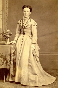
Sepia toned digital image of Isabella Macdonald nee Munroe (1820-1906) Born in Skye, Scotland, Isabella arrived in Melbourne on the 'Glen Huntly' on April 17, 1840. She died at Cranbourne in 1906.Isabella Munroe travelled to Australia with her mother, travelling under her maiden name of Mary McKenzie, on the Glen Huntley, arriving in the Port Phillip District 17 April 1840. The Glen Huntley arrived flying the yellow quarantine flag indicating it was carrying passengers with infectious diseases. Of a passenger complement of 170 passengers, during the voyage 105 contracted various diseases including fever, scarlatina, measles, small pox, and chicken pox. Both Mary and Isabella were held for a period in the camp at Little Red Bluff or Red Cliffs, known today as Point Ormond. Isabella married Alexander Macdonald at Scots Church, Melbourne on 17 February 1841. After their marriage they started the sheep run named Stringy Bark, on the Yarra, near where Kew is today. Sepia toned digital image of Isabella Macdonald standing beside a table.