Showing 174 items matching "local government amalgamation 1994"
-
 Eltham District Historical Society Inc
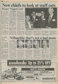
Newspaper - Newspaper article, Diamond Valley News, New chiefs to look at staff cuts; Wages 'biggest cost' by Jodie Haythorne, Diamond Valley News, December 21, p3, 1994
And - Nillumbik: that's not a bad name by Fiona Kaegicouncil amalgamation, shire of eltham, shire of montsalvat, shire of nillumbik, 1994, city of banyule, city of heidelberg, local government board, montsalvat, shire of diamond valley -
 Eltham District Historical Society Inc
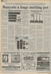
Newspaper - Newspaper article, Diamond Valley News, Banyule a huge melting pot by Jodie Menzies, Diamond Valley News, December 21, p8, 1994
council amalgamation, shire of eltham, shire of montsalvat, shire of nillumbik, 1994, city of banyule, city of heidelberg, local government board, montsalvat, shire of diamond valley -
 Eltham District Historical Society Inc
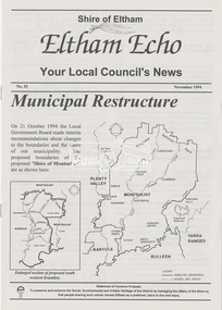
Newsletter, Eltham Echo; Your Local Council's News, Shire of Eltham, No. 35, November 1994, 1994
Feature articles include: . Municipal Restructure . The End of An Era: The Shire of Eltham 1871-1994 by Russell Yeoman, Eltham Historical Society . Eltham Festival 11-12-13 Nov 1994The last newsletter of the Shire of Eltham prior to its cessation as a municipal local government authority and restructure with parts of the City of Heidelberg and Shire of Diamond Valley to form the Shire of Nillumbik and City of Banyule effective from 15 December 1994.8 page newsletter; 2 x A3 pages copy folded and stapled1994, council amalgamation, eltham echo, eltham festival, municipal restructuring, russell yeoman, shire of eltham, shire of eltham historical society -
 Greensborough Historical Society
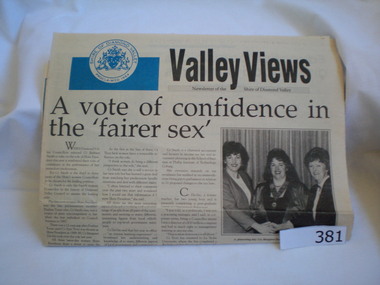
Magazine, Shire of Diamond Valley, Valley Views. October1991. October/November 1994, 1991_10
Valley Views was the newsletter of the Shire of Diamond Valley. The Shire of Diamond Valley was a Local Government Area located about 20 kilometres northeast of Melbourne. The shire covered an area of 74.38 square kilometres and existed from 1964 until 1994. 1994 edition commemorates the 30th anniversary of the Shire of Diamond Valley, in the final year before the Victorian state government amalgamated local government areas.Two editions of Valley Views. 1991 edition is 8 pages in broadsheet format (40 x 29cm), black and white illustrations. 1994 edition is 12 pages, colour illustrations, A4 (30 x 21 cm).shire of diamond valley, greensborough, valley views, diamond valley -
 Glenelg Shire Council Cultural Collection
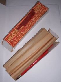
Functional object - Box of sealing wax, n.d
Possibly from the Portland Town Council collection.Artefacts relating to the Portland Town Council represent the history of the Glenelg Shire and how it came to be. The Glenelg Shire Council was established by an Order-in-Council under the Local Government Act 1989, published in the Victorian Government Gazette S63 on 23 September 1994. Three councils were amalgamated, the City of Portland and the Shires of Glenelg and Heywood, to form the new Glenelg Shire.Cardboard box containing 11 full sticks and 5 partial sticks of sealing wax. Sealing wax embossed with maker detailsFront: Orange and yellow paper label on top. S. Maw, Son and Sons Fine sealing wax Crest in centre with London Englandportland town council, local government, glenelg shire, administration -
 City of Moorabbin Historical Society (Operating the Box Cottage Museum)
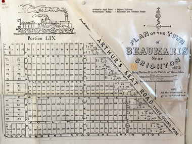
Document, photocopy of Plan of Beaumaris 1853, c1960
... . .Since the Amalgamation of Councils 1994 the local government.... .Since the Amalgamation of Councils 1994 the local government ...Beaumaris includes two early estates in the parish of Moorabbin developed by Josiah Holloway from 1852. Named Beaumaris Town and Beaumaris Estate (after the pastoral run in the area and ultimately after Beaumaris in Wales), the lots comprising them were marketed by Mr Holloway's suggesting that the railway was imminent and a canal would be built. The township developed slowly, a Post Office opened on 1 March 1868, but was replaced next month by Gipsy Village office (now Sandringham) In 1862 Beaumaris was one of the early settler communities within the boundaries of the Moorabbin District Roads Board , the region’s first local government authority. Beaumaris is a suburb in Melbourne, Victoria, Australia, 19 km south-east from Melbourne's central business district. .Since the Amalgamation of Councils 1994 the local government area is the City of Bayside which includes Brighton. A Photocopy of the Plan of Beaumaris 1853 A3moorabbin, county of bourke, brighton, beaumaris, pioneers, early settlers. market gardeners, cheltenham, king. john, holloway josiah, whorral charles, arthur’s seat road, nepean highway, morabbin district roads board, sandringham, mordialloc, mentone -
 Eltham District Historical Society Inc
Negative - Photograph, George W. Bell, Excavation of site for new Eltham Shire Office building, 895 Main Road, Eltham, 1964
... the Kennett Government amalgamation of local government areas in 1994... the Kennett Government amalgamation of local government areas in 1994 ...Black and white photograph of bulldozer excavating the former Shillinglaw Cottage site for new Shire Offices. 'Shillinglaw Trees' in background. The cottage and land were purchased by the Shire of Eltham as the site for a new shire office building. The cottage was destined for demolition but members of the community concerned at losing one of the areas earliest buildings (built c.1859) initiated a fund-raising campaign to save the cottage. In 1964 the cottage was dis-assembled, all the bricks numbered and reassembled several hundred meters to the south on a site between the Gahan house and the Eltham Railway Trestle Bridge (present-day Panther Place), which became known as the Eltham Common. The new shire offices at 895 Main Road were opened in 1965. Following the Kennett Government amalgamation of local government areas in 1994, the Shire of Eltham ceased to exist, and a new Shire of Nillumbik was created 15 December 1994 from the former Eltham shire and parts of the Diamond Valley shire. The former West Riding which included parts of Montmorency, Lower Plenty and Briar Hill were ceded to the new City of Banyule. Commissioners were appointed for several years and the new Council occupied the former offices of the Shire of Diamond Valley in Greensborough. The former Eltham Shire offices remained vacant until August 1996 the Commissioners suddenly elected to have the former Shire offices demolished immediately and the site has remained vacant ever since. It was not until 1997 before the community was allowed to democratically elect new Councillors to represent them. This photo forms part of a collection of photographs gathered by the Shire of Eltham for their centenary project book,"Pioneers and Painters: 100 years of the Shire of Eltham" by Alan Marshall (1971). The collection of over 500 images is held in partnership between Eltham District Historical Society and Yarra Plenty Regional Library (Eltham Library) and is now formally known as the 'The Shire of Eltham Pioneers Photograph Collection.' It is significant in being the first community sourced collection representing the places and people of the Shire's first one hundred years.Digital image 4 x 5 inch B&W Negeltham, eltham shire office, excavation, george w. bell collection, main road, municipal offices, shillinglaw cottage, shillinglaw trees, shire of eltham pioneers photograph collection, shire offices, significant tree -
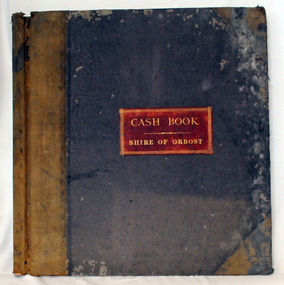
 Orbost & District Historical Society
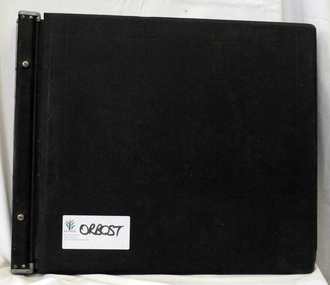
ledger, LOAN ACCOUNT CASH BOOK SHIRE OF ORBOST, 1935-1971
This ledger was used by the Shire of Orbost from 1935-1971. The item was donated to Orbost & District Historical society from P.R.O.V. as a Place of Deposit (POD) item for safe keeping by a local history group or museum. The shire covered an area of 9,347 square kilometres and existed from 1892 until 1994 when it became part of the East Gippsland Shire Council. Orbost was at first included in the Bairnsdale Shire from 1882 and was later part of the Tambo Shire. Because of travelling distances the Croajingalong Shire was created in 1892 (name changed to Orbost Shire 17.2.1893 with James Cameron as the first Shire President. In 1994 it amalgamated to become part of East Gippsland Shire Council. This item comprises records that belonged to the local government accounting system. The Shire of Orbost Council no longer exists having been absorbed by the East Gippsland Shire Council. This is a hand-written record created before the widespread use of computer accounting records.A black, hard cover ledger with light brown leather binding. it is titled "CASh BOOK LOAN ACCOUNT, SHIRE OF ORBOST". Records are hand-written. Inside the back cover is a loose-leaf typed document titled, "Shire Engineers Report 11 Sept 1970".cash-book ledger shire-of-orbost accounting -
 Orbost & District Historical Society
ledger, TREASURER'S CASH BOOK, 1898 - 1912
This ledger was used by the Shire of Orbost from 1898 to 1912. The item was donated to Orbost & District Historical society from P.R.O.V. as a Place of Deposit (POD) item for safe keeping by a local history group or museum. The shire covered an area of 9,347 square kilometres and existed from 1892 until 1994 when it became part of the East Gippsland Shire Council. Orbost was at first included in the Bairnsdale Shire from 1882 and was later part of the Tambo Shire. Because of travelling distances the Croajingalong Shire was created in 1892 (name changed to Orbost Shire 17.2.1893 with James Cameron as the first Shire President. In 1994 it amalgamated to become part of East Gippsland Shire Council. This item contains handwritten accounting records of the Shire of Orbost. The Orbost Shire local government no longer exists as it was absorbed by the East Gippsland Shire Council.A black, hard cover ledger with light brown leather binding. It is titled "TREASURER'S CASH BOOK" and contains hand-written records.orbost-shire-council ledger-accounts -
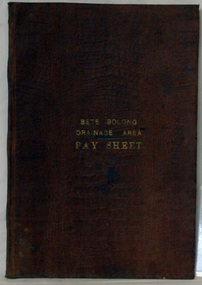 Orbost & District Historical Society
account book, BETE BOLONG DRAINAGE AREA PAY SHEET, 1910 - 1913
This account book was used by the Orbost Shire council to record payments made for work done on the Bete Bolong Drainage Area between 1910 and 1913. The item was donated to Orbost & District Historical society from P.R.O.V. as a Place of Deposit (POD) item for safe keeping by a local history group or museum. The shire covered an area of 9,347 square kilometres and existed from 1892 until 1994 when it became part of the East Gippsland Shire Council. Orbost was at first included in the Bairnsdale Shire from 1882 and was later part of the Tambo Shire. Because of travelling distances the Croajingalong Shire was created in 1892 (name changed to Orbost Shire 17.2.1893 with James Cameron as the first Shire President. In 1994 it amalgamated to become part of East Gippsland Shire Council. This item is a hand-written record of the accounts of the local government. The Orbost Shire Council no longer exists having been absorbed by the East Gippsland Shire Council.A brown leatherette, hard cover book. In gold lettering on the front is "BETE BOLONG DRAINAGE AREA PAY SHEET". It contains records of payments made for work done 1910-1913.In gold lettering on the front is "BETE BOLONG DRAINAGE AREA PAY SHEET".bete-bolong-drainage-area accounts orbost-shire -council -
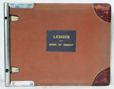 Orbost & District Historical Society
ledger, 1950's
This ledger was used by the Shire of Orbost in 1959. The item was donated to Orbost & District Historical society from P.R.O.V. as a Place of Deposit (POD) item for safe keeping by a local history group or museum. The shire covered an area of 9,347 square kilometres and existed from 1892 until 1994 when it became part of the East Gippsland Shire Council. Orbost was at first included in the Bairnsdale Shire from 1882 and was later part of the Tambo Shire. Because of travelling distances the Croajingalong Shire was created in 1892 (name changed to Orbost Shire 17.2.1893 with James Cameron as the first Shire President. In 1994 it amalgamated to become part of East Gippsland Shire Council. This is a handwritten record of revenue accounts from local government. The Shire of Orbost as a local government no longer exists havinb absobed into the East Gippsland Shire Council.A heavy ledger with a brown cover and steel bindings. The covers are probably wooden. It is alphabetically indexed and the ledger is lockable. it contains revenue accounts for 1959. On the front cover is "LEDGER (underlined) SHIRE OF ORBOST" in gold print. It is an "Emu Binder".accounts-shire-of-orbost local-government -
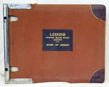 Orbost & District Historical Society
ledger, 1950's -1960's
This ledger was used bt the Shire of Orbost local government to record Country Roads Board accounts 1950's and 1960's. The item was donated to Orbost & District Historical society from P.R.O.V. as a Place of Deposit (POD) item for safe keeping by a local history group or museum. The shire covered an area of 9,347 square kilometres and existed from 1892 until 1994 when it became part of the East Gippsland Shire Council. Orbost was at first included in the Bairnsdale Shire from 1882 and was later part of the Tambo Shire. Because of travelling distances the Croajingalong Shire was created in 1892 (name changed to Orbost Shire 17.2.1893 with James Cameron as the first Shire President. In 1994 it amalgamated to become part of East Gippsland Shire Council. The Country Roads Board was the government authority for the construction and maintenance of main roads in Victoria between 1913 and 1983. It was succeeded by the Road Construction authority on 1 July 1983 and later merged with the Road Traffic Authority on July 1 1989 to form the Roads Corporation. James Cameron, an Orbost farming pioneer and Member of the Legislative Assembly, fathered the Country Roads Board. This ledger is a hand-written record of accounts for the Orbost Shire local council. It pre-dates computer records. The Orbost Shire Council no longer exists having been absorbed into the East Gippsland Shire Council.A heavy brown coloured ledger with covered wooden covers. it has steel metal binding. Inside are strips of paper marking pages. It contains blue ink hand-written records of monies in/out (?) to Shire of Orbost Council. On the front cover inside a black rectangle in gold print is " LEDGER COUNTRY ROADS BOARD ACCOUNT ORBOST". It is an "Emu Binder".ledger orbost-shire accounts country-roads-board -
 Orbost & District Historical Society
ledger, 1950's ; 1960's
This ledger was used by the Shire of Orbost to record transactions with the Country Roads board in 1950's and 1960's. The item was donated to Orbost & District Historical society from P.R.O.V. as a Place of Deposit (POD) item for safe keeping by a local history group or museum. The shire covered an area of 9,347 square kilometres and existed from 1892 until 1994 when it became part of the East Gippsland Shire Council. Orbost was at first included in the Bairnsdale Shire from 1882 and was later part of the Tambo Shire. Because of travelling distances the Croajingalong Shire was created in 1892 (name changed to Orbost Shire 17.2.1893 with James Cameron as the first Shire President. In 1994 it amalgamated to become part of East Gippsland Shire Council. The Country Roads Board was the government authority for the construction and maintenance of main roads in Victoria between 1913 and 1983. It was succeeded by the Road Construction authority on 1 July 1983 and later merged with the Road Traffic Authority on July 1 1989 to form the Roads Corporation. James Cameron, an Orbost farming pioneer and Member of the Legislative Assembly, fathered the Country Roads Board. This item is a hand-written record of accounts of the Orbost Shire local Government. It pre-dates computer records,The Shire of Orbost Council no longer exists having been absorbed into th East Gippsland Shire council.A heavy brown coloured ledger with steel bindings. Covers are probably wooden. It contains hand-written records of transactions the Country Roads Board. -
 Orbost & District Historical Society
ledger, late 1950's - 1970's
This ledger was used by the Shire of Orbost in the late 1950's - 1970's.The item was donated to Orbost & District Historical society from P.R.O.V. as a Place of Deposit (POD) item for safe keeping by a local history group or museum. The shire covered an area of 9,347 square kilometres and existed from 1892 until 1994 when it became part of the East Gippsland Shire Council. Orbost was at first included in the Bairnsdale Shire from 1882 and was later part of the Tambo Shire. Because of travelling distances the Croajingalong Shire was created in 1892 (name changed to Orbost Shire 17.2.1893 with James Cameron as the first Shire President. In 1994 it amalgamated to become part of East Gippsland Shire Council. The Country Roads Board was the government authority for the construction and maintenance of main roads in Victoria between 1913 and 1983. It was succeeded by the Road Construction authority on 1 July 1983 and later merged with the Road Traffic Authority on July 1 1989 to form the Roads Corporation. James Cameron, an Orbost farming pioneer and Member of the Legislative Assembly, fathered the Country Roads Board This item is a hand-written record of Orbost Shire Council accounts. It pre- dates computer records. The Shire of Orbost local council no longer exists having been absorbed by the East Gippsland Shire Council.A black ledger with wooden covers. It contains hand-written records of transactions between Orbost Shire Council and the Country Roads Board.bottom left corner - Orbost in black on a white East Gippsland Shire logoledger accounts shire-of-orbost country-roads-board -
 Orbost & District Historical Society
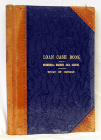
cash book, first half 20th century
This ledger was used by the Shire of Orbost to record transactions relating bto the Newmerella Drainage Area from 1927 to 1950. The item was donated to Orbost & District Historical society from P.R.O.V. as a Place of Deposit (POD) item for safe keeping by a local history group or museum. The shire covered an area of 9,347 square kilometres and existed from 1892 until 1994 when it became part of the East Gippsland Shire Council. Orbost was at first included in the Bairnsdale Shire from 1882 and was later part of the Tambo Shire. Because of travelling distances the Croajingalong Shire was created in 1892 (name changed to Orbost Shire 17.2.1893 with James Cameron as the first Shire President. In 1994 it amalgamated to become part of East Gippsland Shire Council.This item is a hand-written record of the accounts of the Orbost Shire local government. It pre-dates computer records. The Orbost Shire Council no longer exists having been absorbed into the East Gippsland Shire Council. A ledger with a black cover and brown binding. It has marbled end covers. It contains handwritten records of transactions relating to the Newmerella Drainage Area. On the front cover in gold print is "LOAN CASH BOOK (underlined) NEWMERELLA DRAINAGE AREA ACCOUNT (underlined) SHIRE OF ORBOST". on spine - "Newmerella Drainage Area Cash Book" in gold print.orbost-shire-council ledger accounts newmerella-drainage-area -
 Orbost & District Historical Society
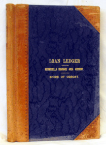
ledger, first half 20th century
This ledger was used by the Shire of Orbost from 1927 -1940. The item was donated to Orbost & District Historical society from P.R.O.V. as a Place of Deposit (POD) item for safe keeping by a local history group or museum. The shire covered an area of 9,347 square kilometres and existed from 1892 until 1994 when it became part of the East Gippsland Shire Council. Orbost was at first included in the Bairnsdale Shire from 1882 and was later part of the Tambo Shire. Because of travelling distances the Croajingalong Shire was created in 1892 (name changed to Orbost Shire 17.2.1893 with James Cameron as the first Shire President. In 1994 it amalgamated to become part of East Gippsland Shire Council. This item is a handwritten record of the accounts of the Orbost Shire local government. It pre-dates computer records. The Orbost Shire Council no longer exists having been absorbed by the East Gippsland Shire Council.A ledger with a black cover and brown leather binding. It has marbled end pages. On the front cover in gold print is " LOAN LEDGER (underlined) NEWMERELLA DRAINAGE AREA ACCOUNT (underlined) SHIRE OF ORBOST.on spine - "Newmerella Drainage Area Loan Ledger"ledger orbost-shire newmerella-drainage-area accounts -
 Orbost & District Historical Society
ledger, first quarter 20th century
This ledger was used by the Shire of Orbost from 1910 -1925. The item was donated to Orbost & District Historical society from P.R.O.V. as a Place of Deposit (POD) item for safe keeping by a local history group or museum. The shire covered an area of 9,347 square kilometres and existed from 1892 until 1994 when it became part of the East Gippsland Shire Council. Orbost was at first included in the Bairnsdale Shire from 1882 and was later part of the Tambo Shire. Because of travelling distances the Croajingalong Shire was created in 1892 (name changed to Orbost Shire 17.2.1893 with James Cameron as the first Shire President. In 1994 it amalgamated to become part of East Gippsland Shire Council. This item is a hand-written record of the accounts of the Orbost Shire local government. It pre-dates computer records. The Orbost Shire council no longer exists having been absorbed by the East Gippsland Shire council.A ledger with ablack cover with brown leather binding.Pages have marbled edges. It contains hand-written records of transactions relating to the Bete Bolong South Drainage Area.on spine - gold lettering on red " Cash Book" and "Bete Bolong South Drainage Area" ; gold lettering on black " Shire of Orbost"ledger orbost-shire accounts bete-bolong-south-drainage-area -
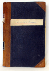 Orbost & District Historical Society
creditors' ledger, 1901 - 1960
This creditors' ledger records information about Shire purchases. The purpose of the Creditors Ledger is to provide knowledge about which suppliers the Shire has paid money to. This ledger was used by the Shire of Orbost pound keeper from 1901 -1960. The item was donated to Orbost & District Historical society from P.R.O.V. as a Place of Deposit (POD) item for safe keeping by a local history group or museum. The shire covered an area of 9,347 square kilometres and existed from 1892 until 1994 when it became part of the East Gippsland Shire Council. Orbost was at first included in the Bairnsdale Shire from 1882 and was later part of the Tambo Shire. Because of travelling distances the Croajingalong Shire was created in 1892 (name changed to Orbost Shire 17.2.1893 with James Cameron as the first Shire President. In 1994 it amalgamated to become part of East Gippsland Shire Council. This item is a hand-written record of the accounts of the Orbost Shire local government. It pre-dates computer records. The Orbost Shire council no longer exists having been absorbed by the East Gippsland Shire council.A large book with a black patterned cover with brown binding, it contains records handwritten in ink. These are records of money paid out by the local government. There are typewritten sheets of sundry creditors added to the back section of the book.hand-written on front cover on white sticker - " Creditor's Ledger" on spine in gold on red - "Ledger" ; on black - "Shire of Orbost" accounts ledger orbost-shire-council -
 Orbost & District Historical Society
credit ledger, 1892-1909
This ledger was used by the Shire of Orbost from 1892 - 1909. The item was donated to Orbost & District Historical society from P.R.O.V. as a Place of Deposit (POD) item for safe keeping by a local history group or museum. The shire covered an area of 9,347 square kilometres and existed from 1892 until 1994 when it became part of the East Gippsland Shire Council. Orbost was at first included in the Bairnsdale Shire from 1882 and was later part of the Tambo Shire. Because of travelling distances the Croajingalong Shire was created in 1892 (name changed to Orbost Shire 17.2.1893 with James Cameron as the first Shire President. In 1994 it amalgamated to become part of East Gippsland Shire Council. This is a hand-written record of the accounts of the local government. The Orbost Shire Council no longer exists having been absorbed into the East Gippsland Shire Council.A heavy ledger with a dark brown cover and lighter brown binding. it has marbled end covers and marbled page edges. It contains accounts records hand-written in ink.on spine in gold lettering - on a red square : "Ledger" - on a black square : "Shire of Orbost"accounts ledger orbost-shire-council -
 Orbost & District Historical Society
cash book, 1893-1899
This ledger was used by the Shire of Orbost from 1893-1899 . The item was donated to Orbost & District Historical society from P.R.O.V. as a Place of Deposit (POD) item for safe keeping by a local history group or museum. The shire covered an area of 9,347 square kilometres and existed from 1892 until 1994 when it became part of the East Gippsland Shire Council. Orbost was at first included in the Bairnsdale Shire from 1882 and was later part of the Tambo Shire. Because of travelling distances the Croajingalong Shire was created in 1892 (name changed to Orbost Shire 17.2.1893 with James Cameron as the first Shire President. In 1994 it amalgamated to become part of East Gippsland Shire Council This is a handwritten record of the financial transactions of the first Obost Shire Council. This council no longer exists having been absorbed by the East Gippsland Shire Council.A specially printed cash book with a brown cover and lighter brown binding. It has marbled end covers. It contains hand-written accounts of local government transactions .on front inside a red rectangle -"Cash Book Shire of Orbost"cash-book shire-of-orbost accounts -
 City of Moorabbin Historical Society (Operating the Box Cottage Museum)
Photograph - Map of Dendy's Special Survey, 1852 Map of Henry Dendy's Special Survey of 1841, 19th Century
A Map drawn in 1852 that shows the 5,120 acres that formed Dendy's Special Survey of 1841. In 1840 Henry Dendy, a farmer in Surrey, England acquired a "Special Survey" from the Commissioners for Land and Emigration which gave Dendy the right to choose land in Port Phillip for the "bargain basement" price of only £1 per acre for 5120 acres, (an area of 8 square miles). The Special Survey also included the right to "the shipment of a worker for every £20 spent on land, whose free passage was paid by the Crown, equalling a total of 100 workers ". Accordingly Dendy sold his English holdings and paid the required £5120 and arrived in Melbourne in February 1841. However by this time land in the new colony was selling for £5 - £40 per acre. Because Henry Dendy possessed the order from the Colonial Office in London he was able to successfully oppose Governor LaTrobe's attempts to alter the price of the land. Dendy appointed Jonathan Were, (an entrepreneur, who had arrived in 1839), as his Manager and who later became a partner. Together, Dendy and Were decided on an area 5 miles south from Melbourne, bounded by North Road, East Boundary Road, South Road and to the west by Port Phillip Bay. Were and Dendy pitched their tents in the area now known as ' Park St, Brighton' and sank a well near the corner of 'St Andrew's St and Wells St'. By 1845 J.B Were and Company had bought almost half of Dendy's land and Were built himself "Moorabbin House" in Were St Brighton made from stone, quarried from local cliffs. It was still standing in 1924. Legend records Moorabbin is named after the Aboriginal word for ' Mother's Milk ' The soil is very fertile and well supplied with water especially in the area called 'East Brighton' - now known as Bentleigh and East Bentleigh - By 1850 the area had developed with numerous market gardens, dairy farms, fruit gardens and vineyards supplying food for the growing population of Melbourne.This Map shows the birth of the Brighton and Moorabbin area. On 18th January1859 Brighton was proclaimed a Municipality and a Borough by October 1863. Meanwhile, following a Petition, the area of East and South Brighton, incorporating Mordialloc, Cheltenham, Mentone, Sandringham and Oakleigh separated from Brighton to form the Moorabbin District Roads Board becoming the first Local Government Authority. Col. William Mair was elected as the first Chairman of the Moorabbin Roads Board. Moorabbin Shire 1871 developed further and was declared a City in1934. The City of Moorabbin was the largest Municipality in Melbourne before the Amalgamation of Councils in 1994 when it was divided in the south to City of Kingston and in the north to City of Glen Eira A Photo-lithographed 1852 Map showing the 5,120 acres that formed Dendy's Special Survey of 1841. Henry Dendy & Jonathan Were chose an area 5 miles south from Melbourne, bounded by North Road, East Boundary Road, South Road and to the west by Port Phillip Bay. Moorabbin County of Bourke / Photo-Lithographed at the department of Lands and Survey. /Melbourne. / Price 1/- brighton, moorabbin, bentleigh, cheltenham, dendy henry, bent thomas, were jonathan, special survey -
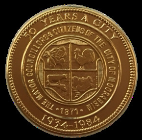 City of Moorabbin Historical Society (Operating the Box Cottage Museum)
Badge - City of Moorabbin - 50 Years Medal, 1984-85
A gold-plated medal issued by the City of Moorabbin to commemorate the quincentenary of Victoria in 1984-5. It features the City Shield incorporating vegetables, a rooster, a cow and a house, and the sesquicentenary logo. The township of Moorabbin, known as South Brighton until 1909, remained small, with the Plough and Harrow Hotel as its main building. In 1917 Sandringham borough was formed by severance from Moorabbin shire and in 1920 Mentone and Mordialloc were also severed. In the remaining Moorabbin shire the Moorabbin township was still small (1,770 persons), but the shire grew in population during the 1930s. On 10 October 1934 it was proclaimed a city. It existed as a separate municipality until 1995. When local government boundaries were changed in 1994 about half of Moorabbin city was united with Glen Eira city and about half with Kingston city. On 15 December, 1994 the City of Chelsea, parts of the Cities of Mordialloc, Moorabbin, Springvale and Oakleigh were amalgamated to create the City of Kingston by Order of the Governor in Council. On the same day Glen Eira City Council was formed from the City of Caulfield and the remaining part of the City of Moorabbin.Gold Plated Medal Side one: Within a wide rim formed by a line circle, the City Shield incorporating vegetables, a rooster, a cow and a house; around, THE MAYOR COUNCILLORS & CITIZENS OF THE CITY OF MOORABBIN; around on broad rim, 50 YEARS A CITY 1934 - 1984. Side 2: Logo of the Victorian sesquicentenary; below, VICTORIA 150 / GROWING TOGETHER 1984-5 at rim in small letters the mint name, BRIM MELBTHE MAYOR COUNCILLORS & CITIZENS OF THE CITY OF MOORABBIN; VICTORIA 150 / GROWING TOGETHER 1984-5.city of moorabbin, victorian sesquincentenary, moorabbin shire, councillors moorabbin, cheltenham, bentleigh, moorabbin, le page family, cr coates l.r, cr sheppard l.a., cr cooper j.c. -
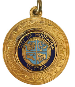 City of Moorabbin Historical Society (Operating the Box Cottage Museum)
Badge - City of Moorabbin Key Chain
“City of Moorabbin” The township of Moorabbin, known as South Brighton until 1909, remained small, with the Plough and Harrow Hotel as its main building. In 1917 Sandringham borough was formed by severance from Moorabbin shire and in 1920 Mentone and Mordialloc were also severed. In the remaining Moorabbin shire the Moorabbin township was still small (1,770 persons), but the shire grew in population during the 1930s. On 10 October 1934 it was proclaimed a city. It existed as a separate municipality until 1995. When local government boundaries were changed in 1994 about half of Moorabbin city was united with Glen Eira city and about half with Kingston city. On 15 December, 1994 the City of Chelsea, parts of the Cities of Mordialloc, Moorabbin, Springvale and Oakleigh were amalgamated to create the City of Kingston by Order of the Governor in Council. On the same day Glen Eira City Council was formed from the City of Caulfield and the remaining part of the City of Moorabbin.Gold Key ring with a dark blue circle surrounding the shield of the City of Moorabbin.City of Moorabbin, Victoria,city of moorabbin -
 City of Moorabbin Historical Society (Operating the Box Cottage Museum)
Programme - Two Programs for Mayoral Functions held in the City of Moorabbin. 1946 & 1953, City of Moorabbin Council, 1946 & 1953
“City of Moorabbin” The township of Moorabbin, known as South Brighton until 1909, remained small, with the Plough and Harrow Hotel as its main building. In 1917 Sandringham borough was formed by severance from Moorabbin shire and in 1920 Mentone and Mordialloc were also severed. In the remaining Moorabbin shire the Moorabbin township was still small (1,770 persons), but the shire grew in population during the 1930s. On 10 October 1934 it was proclaimed a city. It existed as a separate municipality until 1995. When local government boundaries were changed in 1994 about half of Moorabbin city was united with Glen Eira city and about half with Kingston city. On 15 December, 1994 the City of Chelsea, parts of the Cities of Mordialloc, Moorabbin, Springvale and Oakleigh were amalgamated to create the City of Kingston by Order of the Governor in Council. On the same day Glen Eira City Council was formed from the City of Caulfield and the remaining part of the City of Moorabbin.Official functions held in the City of Moorabbin 1946 & 1953Two program cards, one green 1946 and the other cream 1953. The inside lists the entertainment during the reception of the Mayoral functions of the City of Moorabbina) RECEPTION /given by the / MAYOR AND MAYORESS / of MOORABBIN / 1946 b) RECEPTION / given by the / MAYORESS of MOORABBIN / 1953mcc, marriott, ward, coates, city of moorabbin, reception, program cards, entertainment, market gardeners, early settlers, cheltenham, moorabbin, bentleigh -
 Port Melbourne Historical & Preservation Society
Flyer, City of Port Phillip, City of Port Phillip, Community News Bulletin. No 1 July 1994, Jul 1994
First community news bulletin from new City of Port Phillip after amalgamation.City of Port Phillip, Community News Bulletin. No 1 July 1994 . A4 white flyer with blue printing text on one side and yellow and blue map of Port Phillip on reverse.local government - city of port phillip, des clark, lynne wenic, geoff vincent, jon hickman -
Port Melbourne Historical & Preservation Society
Newspaper - Death Notice for Port Melbourne as an independent municipal district, Terry Keenan, 23 Jun 1994
... into Port Phillip, 1994 amalgamation local government - city of port ...Written by Terry Keenan and put into the Herald Sun at the time of the Port Melbourne Council amalgamation with South Melbourne and St Kilda into Port Phillip, 1994Death Notice for Port Melbourne! Inserted by Terry Keenan. "Born 1860. Died 1994. Aged 134 years. Known affectionately far and wide as 'The Borough' . Died fighting game to the last, succumbed eventually to the marauding barbarians. Deeply mourned by her countless sons and daughters. R.I.P."amalgamation, local government - city of port melbourne, local government - city of port phillip, herald sun, terry keenan -
Port Melbourne Historical & Preservation Society
Clothing - Armband, Port Melbourne City Council Parking Attendant
... by Council parking attendant up until amalgamation in 1994 Local ...Used by Council parking attendant up until amalgamation in 1994Two black fabric armbands with white embroidered lettering "PMCC Parking Attendant" used by Port Melbourne Council parking attendant up until 1994 amalgamationlocal government - city of port melbourne, transport - motor vehicles -
Port Melbourne Historical & Preservation Society
Container - Bottle, Vintage Port, amalgamation of Port Melbourne, South Melbourne and St Kilda, 1994
Presented to David Graham, last Port Melbourne Town Clerk, by Liana Thompson in 1994.Original bottle of "Vintage Port" labelled in 1994 on amalgamation of Port Melbourne with South Melbourne and St Kilda to form the City of Port Phillip. Signed by the last Mayor of Port Melbourne, Liana Thompson, in her favourite colour purple."Vintage Port" label 1839-1994celebrations fetes and exhibitions, local government, councillors, politics, amalgamation, town clerks, david graham, liana thompson, mayors -
Port Melbourne Historical & Preservation Society
Container - Bottle, Vintage Port, amalgamation of Port Melbourne, South Melbourne and St Kilda, 1994
This is one of the bottles ordered for "the wake" held last Sunday of May, 1994, in the Town HallOriginal bottle of "Vintage Port" labelled in 1994 on amalgamation of Port Melbourne with South Melbourne and St Kilda to form the City of Port Phillip. Blue and maroon ribbons attached."Vintage Port" label 1839-1994celebrations fetes and exhibitions, local government, councillors, politics, amalgamation, town clerks, liana thompson, mayors, david graham -
Port Melbourne Historical & Preservation Society
Document - Port Melbourne Council, Municipal restructure 1984-86, 1984
File of papers compiled and retained by Wendy MORRIS, the Port Melbourne City Librarian, who was also the Municipal Officers' Association representative and a member of the Port Melbourne branch of the ALP. Given to PMH&PS in 1994.Miscellaneous papers relating to the proposal to amalgamate various Councils in 1984. In manilla folder with green spine.local government - city of port melbourne, wendy morris, amalgamation