Showing 56 items
matching pioneers tower
-
 Eltham District Historical Society Inc
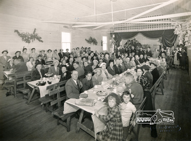
Photograph, Stuart Tomkin, Official guests being entertained Kangaroo Ground Hall after Dedication of Tower and Cottage by Governor Sir Dallas Brooks, 16 Nov 1951, 16/11/1951
Original title: Official guests being entertained Kangaroo Ground Hall after Dedication of Tower and Cottage by Gen. Sir Dallas Brooks, K.C.B., C.M.G., D.S.O., K.St.J., 16 Nov 1951Black and white photograph of guests seated at three rows of tables, celebration dinner Shire of Eltham Pioneers Photo Collection, no. 414 (duplicate of hard copy held at Eltham Library)shire of eltham, ceremonies, sepp, kangaroo ground hall -
 Eltham District Historical Society Inc
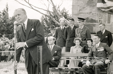
Photograph, Sir Dallas Brookes, Kangaroo Ground Memorial, 1951, 16 November, 1951
Black and white photograph of Sir Dallas Brookes meeting special guests, at re-dedication of Shire of Eltham War Memorial - Kangaroo Ground Tower of Remembrance 16 November, 1951. Also held in the Shire of Eltham Pioneer Photograph Collection.kangaroo ground memorial, war memorial, sir dallas brookes, ceremonies, sepp -
 Eltham District Historical Society Inc
Photograph, Sir Dallas Brookes, Kangaroo Ground Memorial, 1951, 1951
Black and white photograph of Sir Dallas Brookes and dignitaries at re-dedication of Kangaroo Ground Tower of Remembrance, Shire of Eltham War Memorial 16 November 1951. Also part of the Shire of Eltham Pioneers Photograph collectionkangaroo ground memorial, war memorial, sir dallas brookes, ceremonies, sepp -
 Eltham District Historical Society Inc
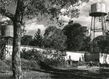
Photograph, Water tanks
Black and white photograph of a building with two water tanks on towers (at Montsalvat?)pioneers and painters, water tank -
 Eltham District Historical Society Inc
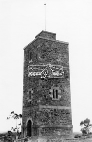
Photograph, Shire of Eltham War Memorial Tower. Eltham-Yarra Glen Road, Kangaroo Ground, unveiled 11 November 1926, c.1926
This photo forms part of a collection of photographs gathered by the Shire of Eltham for their centenary project book,"Pioneers and Painters: 100 years of the Shire of Eltham" by Alan Marshall (1971). The collection of over 500 images is held in partnership between Eltham District Historical Society and Yarra Plenty Regional Library (Eltham Library) and is now formally known as the 'The Shire of Eltham Pioneers Photograph Collection.' It is significant in being the first community sourced collection representing the places and people of the Shire's first one hundred years.Digital imagesepp, shire of eltham pioneers photograph collection, kangaroo ground, war memorial tower -
 Eltham District Historical Society Inc
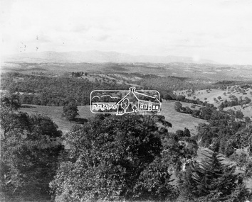
Photograph, View of surrounding district from War Memorial Tower at Kangaroo Ground
This photo forms part of a collection of photographs gathered by the Shire of Eltham for their centenary project book,"Pioneers and Painters: 100 years of the Shire of Eltham" by Alan Marshall (1971). The collection of over 500 images is held in partnership between Eltham District Historical Society and Yarra Plenty Regional Library (Eltham Library) and is now formally known as the 'The Shire of Eltham Pioneers Photograph Collection.' It is significant in being the first community sourced collection representing the places and people of the Shire's first one hundred years.Digital imagesepp, shire of eltham pioneers photograph collection, kangaroo ground, war memorial tower -
 Eltham District Historical Society Inc
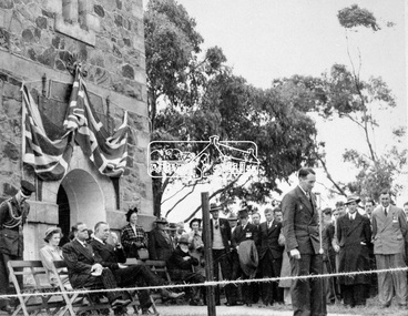
Photograph, Shire of Eltham War Memorial. Dedication of Tower and Cottage, 16 November 1951
Source: Shire of ElthamThis photo forms part of a collection of photographs gathered by the Shire of Eltham for their centenary project book,"Pioneers and Painters: 100 years of the Shire of Eltham" by Alan Marshall (1971). The collection of over 500 images is held in partnership between Eltham District Historical Society and Yarra Plenty Regional Library (Eltham Library) and is now formally known as the 'The Shire of Eltham Pioneers Photograph Collection.' It is significant in being the first community sourced collection representing the places and people of the Shire's first one hundred years.Digital imagesepp, shire of eltham pioneers photograph collection, kangaroo ground, war memorial tower, dedication, sir dallas brooks -
 Flagstaff Hill Maritime Museum and Village
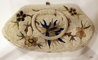
Accessory - Bag, 1930's
In the words of Donor, Betty Stone, "Owned by my aunt Mrs Elsie Mary (nee Dale) Towers, born 24 December 1895, daughter of Ellis and Ann Dale, of Latrigg, Wangoom, Warrnambool. This beaded bag was a personal gift from Miss Lake to Elsie Dale sometime in the early 1930s. Miss Lake was a member of a leading Warrnambool family whose property Lyndoch was situated by the banks of the Hopkins River. After completing her nursing course at Warrnambool Hospital and working there for a time, Elsie Dale was appointed Sister-in-Charge of the newly formed Baby Health Centre, which initially operated in temporary accommodation at or near the Council Chambers. In 1928 the Centre moved into new brick premises on Liebig Street. The building comprised of five rooms, a back yard and a front veranda where mothers parked their prams. The Warrnambool Standard reported in February 1928. The purpose of the Clinic is to the saving of infant's life. Many mothers attended the Clinic in the former location. They were able to acquire valuable knowledge from Sister Dale who is in charge of the Clinic and also have their infants weighed and measured each week. During the early days of the Centre Miss Lake, as a patron, took a keen interest in all aspects of the Centre and co-operated very closely with Sister Dale. Miss Lake would often call in at the centre while her uniformed chauffeur would wait beside her limousine parked in the street outside the Baby Heath Centre. I also recall my aunt driving to Lyndoch to discuss matters concerning the Centre with Miss Lake. Miss Lake purchased this evening bag in England, and upon her return from her overseas tour in the early 1930s, presented it to Sister Dale as a token of appreciation. Dedicated to her vocation, Sister Dale gave unstintingly of her effort, time and resources to create an attractive venue for mothers to visit. Her contribution to the welfare of all mothers and babies in the Warrnambool area, particularly during the Depression years, was considerable. Sister Dale, who drove a Dodge Tourer car, visited mothers in their homes when necessary and regularly visited the indigenous settlement at Framlingham. Amongst my early childhood memories are those of accompanying my aunt when she drove to the Nestles factory at Dennington to purchase large tins of dried milk baby food which she then delivered to the mothers who lived at the Framlingham settlement. Sister Elsie Dale retired in 1949 and moved to Mooroopna after her marriage to Solomon Towers. (Died aged 75 years 27 July 1971) (Note: For additional information please refer to Betty Stone’s book “Pioneers and Places - A History of three Warrnambool Pioneering Families” ie. Chamberlain, Dale and Lees Families)This item is associated with the families of Chamberlain, Dale and Lees. These families are listed in the "Pioneers' Register" for Warrnambool Township and the Shire, 1835-1900, published by A.I.G.S. Warrnambool Branch. Elsie Dale was the first Sister to work in the newly established Baby Health Centre in Warrnambool.Beaded evening bag or clutch purse. The bag was a gift to Elsie Dale from friend Miss Lake, purchased in England early 1930's. The fabric is covered in tiny white beads and features a floral design in browns and greens. The bag has two bead-covered handles and the lining includes a small pocket. Part of the 'Chamberlain Dale Lees Collection'.flagstaff hill, warrnambool, shipwrecked coast, flagstaff hill maritime museum, maritime museum, shipwreck coast, flagstaff hill maritime village, great ocean road, chamberlain, dale, lees, stone, betty stone, warrnambool pioneers, elsie dale, miss lake, lyndoch, handbag, purse, evening bag, beaded handbag, beaded purse, ladies' accessory, clutch purse, warrnambool baby health centre, infant welfare centre -
 Flagstaff Hill Maritime Museum and Village
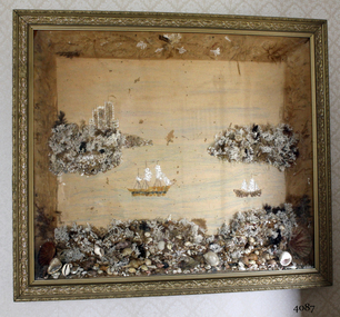
Artwork, other - Wall decoration, late 19th century
This unusual wall decoration was created by Anna Wilson (nee Henry), daughter of pioneer John Stephenson Henry, who arrived in Australia from Ireland with his children in 1851. Family documents confirm that Anna most probably made the diorama for her sister-in-law, who married a member of the Giles family. The diorama was later given to Vera Giles who was a family friend and possibly related to Anna’s sister-in-law by marriage. The diorama is now part of the Giles Collection. Anna married William Wilson in 1860, who had arrived in Australia from County Tarrane in about 1850, aged 19. In 1869 they moved to their new property called ‘Glenlyall’ in Cooramook, north of Grassmere, Victoria, where he lived for 49 years until his death in 1918. He left behind a family of four sons and a daughter. The Giles Family There are many 19th century items of furniture, linen and crockery donated to Flagstaff Hill Maritime Village by Vera and Aurelin Giles. The items are associated with the Giles Family and are known as the “Giles Collection”. These items mostly came from the simple home of Vera’s parents-in-law, Henry Giles and his wife Mary Jane (nee Freckleton), whose photos are in the parlour. They married in 1880. Henry Giles was born at Tower Hill in 1858. He was a labourer on the construction of the Breakwater before leaving in 1895 to build bridges in N.S.W. for about seven years. Mary Jane was born in 1860 at Cooramook. She attended Mailor’s Flat State School where she was also a student teacher before, as family legend has it, she became a governess at “Injemiara” where her grandfather, Francis Freckleton, once owned land. Henry and Mary’s family of six, some of whom were born at Mailor’s Flat and later children at Wangoom, lived with their parents at Wangoom and Purnim west, where Henry died in 1933 and Mary Jane in 1940. The family of the creator Anna Wilson nee Henry and her husband William Wilson are of significance to the early history of Victoria and the South West of Victoria in particular, being pioneer families who farmed the land, built the towns and cities and contributed to their communities. The Giles family collection has social significance at a local level, because it illustrates the level of material support the Warrnambool community gave to Flagstaff Hill when the Museum was established. Wall decoration, diorama with decorative gild frame and glass front. The 3-dimensional seascape includes sailing boats, land and sea, all made from materials such as shells, coral and seaweed. The work was made by Anna Wilson. It is part of the Giles Collection.Noneflagstaff hill, warrnambool, shipwrecked-coast, flagstaff-hill, flagstaff-hill-maritime-museum, maritime-museum, shipwreck-coast, flagstaff-hill-maritime-village, giles collection, henry giles, tower hill, cooramook, warrnambool breakwater, mailor’s flat, wangoom, 19th century household goods, 19th century decor, 19th century handcraft, handcraft, wall hanging, diorama of a seascape -
 Bendigo Historical Society Inc.
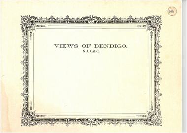
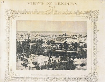
Photograph - VIEWS OF BENDIGO: COPIES OF 52 PHOTOS, 1850 - 1900
Copies of Photographs from - Views of Bendigo by Nicholas Caire Originals in Box 13 No.1 Sandhurst east/ City Reserve x 2 No 2 New Chum Line of Reef No 3 Sandhurst to North from top of Masonic Hall No.4 Hustler's Line of Reef No.5 Battery of stampers for crushing quartz x 2 No.6 View Sandhurst from top of Masonic Hall x 2 No.7 Excavation Quartz Reef, Ironbark Hill. No 8 St. Paul's Church. No.9 View Camp Reserve from Court House. No.10 View of Nth. Old Chum. No.11 View Camp Hill near the Lodge x 2 No.12 Garden Gully. No.13 Shamrock Hotel, Sandhurst. No.14 View from Court House, east end Pall Mall. No.15 Wesleyan Church, Golden Square x 2 No.16 Savings Bank, Sandhurst No.17 Bendigo District Hospital. No.18 Interior Wesleyan Church x 2 No.19 View Golden Square township. No.20 The Town Hall, Sandhurst. No 21 The City Hotel,Sandhurst. No 22 Pall Mall Sandhurst, No 23 Sandhurst City Market No 24 Pall Mall looking west x 2 No 25 Camp Hill x 2 No 26 Charing Cross No 27 View Sandhurst. x 2 No 28 Long Gully. No 29 Railway station and sheds No 30 Cemetery Back Ck. No 31 Kock's Pioneer Quartz Crushing Plant Long Gully. No 32 Masonic Hall. No 33 Bendigo Benevolent Asylum. No 34 Bendigo Flat. No 35 Old Chum Hill x 2 No 36 New Chum Gully No 37 Township of Eaglehawk No 38 From St Paul's tower looking west No 39 Tunnel Big Hill. No 40 From St Paul's tower looking south x 2 No 41 From St Paul's tower looking eastward x 2 No 42 From St Paul's tower looking north west x 2 No 43 Great Extended Hustlers Quartz Mining Claim No 44 Big Hill Rail line x 2 No 45 From St Paul's tower looking westward x 2 No 46 From St Paul's tower looking north west No 47 Big Hill Ranges Buick. x 2 No 48 St.Paul's Tower x 2 No 49 Eaglehawk township. No 50 Mitchell Street No 51 Botanical gardens, White Hills x 2 No 52 View Point, Sandhurst. .N.J. Caire.place, bendigo, bendigo area., views of bendigo. -
 Bendigo Historical Society Inc.
Photograph - NICHOLAS CAIRE VIEWS OF BENDIGO
Full set (52 photos) of Nicholas Caire ''Views of Bendigo'' photographs. 1) Sandhurst East with a portion of the City Reserve. 2) New Chum line of reef. 3) Sandhurst-North part as seen from the top of the Masonic Hall. 4) The Hustler's line of reef seen from Redan Hill. 5) Battery of stampers for crushing quartz 6) View of Sandhurst as seen from the top of the New Masonic Hall. 7) Excavation of quartz reef near Ironbark Hill. 8) St. Paul's Church, tower and belfry. 9) View of the Camp Reserve as seen from the Court House. 10) View of North Old Chum showing surface excavations. 11) View as seen from the Camp Hill near the lodge. 12) Garden Gully amalgamated claims. 13) Shamrock Hotel, Sandhurst. 14) View as seen from Court House showing the willows & East Pall Mall. 15) Wesleyan Church, Golden Square. 16) Savings bank, Sandhurst. 17) The Bendigo district hospital. 18) Interior of the Wesleyan Church, Golden Square. 19) View of Golden Square township. 20) The Town Hall, City of Sandhurst. 21) The City Hotel, Sandhurst. 22) Pall Mall, Sandhurst. 23) Sandhurst City Market. 24) Pall Mall, Sandhurst looking west. 25) View from Camp Hill looking north - east 26) View of Charing Cross, Sandhurst. 27) View of Sandhurst as seen from Knipe's Castle. 28) Township of Long Gully. 29) View taken from St. Paul's tower. 30) View of the Sandhurst cemetery at back creek. 31) Kock's pioneer quartz crushing plant, Long Gully. 32) The New Masonic Hall, Sandhurst. 33) The Bendigo benevolent asylum and industrial school. 34) Bendigo flat as seen from Wattle Hill. 35) View of Old Chum Hill. 36) New Chum Gully as seen from Specimen Hill. 37) Township of Eaglehawk. 38) View from St. Paul's tower looking south west. 39) View of the railway tunnel through the Big Hill, near Mt. Herbert. 40) View taken from St. Paul's looking south. 41) Scene taken from St. Paul's tower looking eastward. 42) View of Sandhurst from St. Paul's tower looking north-west. 43) The great extended Hustler's co's. quartz mining claim. 44) View from the Big Hill showing the line of railway to Melbourne. 45) View from St. Paul's Church tower looking westward. 46) View from St. Paul's Church tower looking north-west. 47) Scene near the Big Hill ranges taken from Mr. Buick's residence. 48) View from St. Paul's Church tower looking north eastward. 49) Township of Eaglehawk 50) View of Mitchell Street, Sandhurst. 51) Botanical gardens near the White Hills. 52) View Point, Sandhurst.bendigo, streetscape, various views, nicholas cairne -
 St James Old Cathedral
Cathedral Building, St James Old Cathedral, 09/11/1839
St James Church, "Church of the Pioneers", was the first Church, first Anglican Church, and is the oldest building in Melbourne. The foundation stone was laid in 1839 by the Superintendent of the District of Bourke, Charles La Trobe, later Governor of the Colony of Victoria. The Church was opened in 1842 and the first Bishop Charles Perry was installed in the Cathedral in 1848 when its status changed to that of Cathedral. Its status changed back to that of a Parish church after 1891 when St Paul's Cathedral in Swanston Street was opened. St James is known as the "Church of the Pioneers" as it served as the place of worship, marriage, baptism and burial of many of the first families in the District of Bourke and the Colony of Victoria. St James Old Cathedral is of the most important historic value to the community of Victoria and to the Australian nation as the first Anglican Church founded within 4 years of the settlement of Melbourne. It represents and conserves the very earliest history of white settlement in Victoria and preserves the church associated history of the Pioneer families of Victoria in its collection of original records and artefacts. Late Neo-Georgian style stone church building with bluestone footings. Octagonal upper one storey bell tower housing eight bells supported by two storey square towers. Body of church has sloping roof and 4 stained glass ornamental windows on each of west and east sides with decorative sanctuary window to the north. Decorative Portico with columns on the north outside elevation. National Trust Commemorative plate on outside wall to right of east entry door. -
 Bendigo Historical Society Inc.
Document - VARIOUS ARTICLES FOR SOCIETY NEWSLETTER, DECEMBER 1971
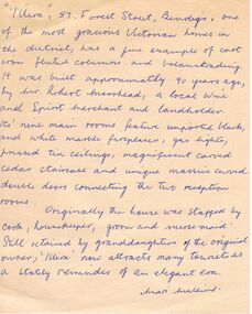
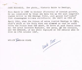
Various articles for Newsletter ('Marunari??) for November???? 1. Re Jack Moorhead (''the most competent engine driver in the Bendigo field'') with handwritten copy of same; 2. 3 pages of handwritten notes for inclusion in the newsletter - various topics; 3. ''The Canons (sic) on Camp Hill'' - history of the Lookout Tower site and flag post, cannons and statue - semi-nude lady - which was damaged in storm and later removed. Source of information for this item attributed to Misses D and D Davenpor, London and the Bendigo Advertiser; handwritten notes re this same article. 4. ''Boys will be boys'' by Mr A Richardson - article based on Annual Report of the Secretary for Mines and Water Supply, 1885 re 11 year old lad who fell down mine; handwritten notes on same article. Various articles for Society newsletter, December 1971; 1. Handwritten note for end of year from President, Neil Murray; 2. Typewritten page titled '' Unknown fate of early diggers'' by W Perry, Eaglehawk; 3. Typewritten article (author - R.A.) re ''The 'Flicks' in (early - deleted?) Bendigo'' - mention of Hill's Open Air Bazaar; ''The Pops'' in the Upper Reserve; the 'Tivoli; the 'Lyseum (sic) ''opposite Lake Weerona''; Wests Pictures in Market Square; the Lyric Theatre; Oscar Flight's orchestra; 4. Handwritten notes (reviews) re book ''Historic Public Buildings of Australia (Cassel - Aust) ''with excellent section on Bendigo'' and book ''These Verdant Plains'' - a history of the Shire of East Loddon (Hawthorn Press); 5. Activities during October (1971?) - typewritten and handwritten copies; 6. Tour report and report on flow of water from the old 'Shamrock' mine, Golden Square - typewritten and handwritten copies; 7. Article re ''Illira'', 57 Forest St, built by Mr Robert Moorhead ca. 1880s, author Mrs B Mullins - handwritten and typewritten copies; 8. Typewritten article describing the ''Bendigo City Market' (handwritten at bottom Mrs Lydia Chancellor, and, Used Dec 1971).document, names of bendigo pioneers -
 Bendigo Historical Society Inc.
Document - VARIOUS ARTICLES FOR NEWSLETTER ('MARUNARI?) FOR NOVEMBER
Various articles for Newsletter ('Marunari??) for November???? 1. Re Jack Moorhead (''the most competent engine driver in the Bendigo field'') with handwritten copy of same; 2. 3 pages of handwritten notes for inclusion in the newsletter - various topics; 3. ''The Canons (sic) on Camp Hill'' - history of the Lookout Tower site and flag post, cannons and statue - semi-nude lady - which was damaged in storm and later removed. Source of information for this item attributed to Misses D and D Davenpor, London and the Bendigo Advertiser; handwritten notes re this same article. 4. ''Boys will be boys'' by Mr A Richardson - article based on Annual Report of the Secretary for Mines and Water Supply, 1885 re 11 year old lad who fell down mine; handwritten notes on same article.document, names of bendigo pioneers, jack moorhead. -
 Stawell Historical Society Inc
Archive - Nespaper Magazine, Stawell & District, 29 June 1935
... Shows Town Hall Pre-Clock tower. Big Hil Pre Pioneer's... grampians Shows Town Hall Pre-Clock tower. Big Hil Pre Pioneer's ...Shows Town Hall Pre-Clock tower. Big Hil Pre Pioneer's Memorial.Photo Spread Sepia Photos people and places in Stawell.The Weekly Times - Magazine Section oages 8-9stawell -
 Ballarat Heritage Services
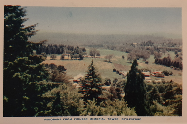
Photograph, Nucolorvue, Panorama from the Pioneed Memorial Tower, Daylesford, 1957
... Daylesford Pioneer memorial Tower... Gardens Wombat Hill Gardens Daylesford Pioneer memorial Tower ...Daylesford is a tourist town in Central Victorian, known for its mineral water springs.Central Springs DaylesfordDaylesford, Victoria, Australia This famous holiday resort is famous for its up-to-date facilities, as well as for its natural attractions. The mineral Springs are renowned for their high medicinal elements. The visitor finds ample to amuse, in excellent fishing, boating, Boating, Swimming, golfing, hiking and riding. The district provides a wide range of typical Australian bush scenery, and the altitude of 2,000 feet above sea level as a tonic effect on all. Daylesford has modern hotels, guest houses, shops and places of amusement, also many other places of interest within short travelling distance. Bendigo, 50 miles, Ballara 30 miles, and Melbourne 75 miles, bring Daylesford within easy reach of many parts of Victoria. daylesford, wombat gardens, wombat hill gardens, daylesford pioneer memorial tower, landscape -
 Bendigo Historical Society Inc.
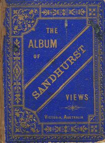
Book - MERLE HALL COLLECTION: THE ALBUM OF SANDHURST VIEWS
A bound book of 16 drawings B&W (lithographs?) in ''photographic'' detail of well-known Sandhurst Views - Town Hall, Mechanics Institute, Masonic Hall, Bendigo Hospital, Bendigo Benevolent Asylum, Post and Telegraph Offices, Mining Exchange, View from Post Office Tower looking East, View from Post Office Tower looking West, Central State School, Alexandra Fountain, Upper Lake,Rosalind Park, Fernery Rosalind Park, St Pauls Church, Bishop's Palace, General View - New Chum Line, Koch's ''Pioneer'' Crushing Works, Quartz Crushing batteries, Town Hall - Eaglehawk, Railway Station. Appended with two pages summarizing Sandhurst history; current councillors and officers, brief review of five places - Bendigo Hospital, Benevolent Asylum, Mechanics Institute and Free Library, School of Mines and Industries, Masonic Hall. Date is given as ''The present (1888) occupants are ....'' -
 Bendigo Historical Society Inc.
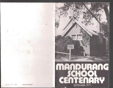
Book - JOHN JONES COLLECTION: MANDURANG SCHOOL CENTENARY SEPTEMBER 1977, September 1977
Small booklet titled Mandurang School Centenary September 1977. It has a black and white picture of the school on the front cover. Mentioned in the book is the History of Mandurang State School and District, Industries, Wine, Milk, Gold, Tannery, The Look-Out, Timber, Hotels, Water Race, Floods, Post Office, Sports, Churches, Fire Brigade, List of Head Teachers 1861 - 1975, The School opens 1877 and Mothers' Club. Photos include Mr & Mrs J T Deravin Pioneer settlers of Mandurang, Deravin's Barn & Wine Cellars, Bernado Togno's Vineyard, Hargreave's Milk Cart, J Pearce & Sons Milk Delivery Bike, The Tannery, Wooden Poppet Head Tower, Kerr's Hotel, The Wine Hall (Previously Junction Hotel), Harry & Len Kofoed's Wood Trucks, Mandurang Recreation Reserve 1977, Mandurang Cricket Club (1889 or thereabouts), Methodist Church, School Pupils 1894, Early School Group, School Pupils 1960 and 1962, Working Bee before shifting School Building to it's Present Site, School Pupils 1922 and School Pupils 1977.Edwin J. Watts. Express Print, Bendigoeducation, primary, mandurang primary school no 1952, john jones collection - mandurang school centenary september 1977, edwin j watts, kevin o'brien, g pearce, j sloan, v togno, r pearce, j french, i adams, b adams, g grose, i kofoed, j pearce, f pentland, g shaw, n todd, i grose, h koefoed, m macdonald, k pearce, t french -
![View of Victoria Hill, Bendigo, taken from Old Chum Hill / [by] Nicholas Caire, circa 1876](/media/collectors/550653872162f11fb04854aa/items/577752a3d0cdd10a5c16e654/item-media/57775308d0cdd10a5c171c46/item-fit-380x285.jpg) Kew Historical Society Inc
Kew Historical Society IncPhotograph, Anglo-Australasian Photographic Company, View of Victoria Hill, Bendigo, taken from Old Chum Hill, c. 1876
Nicholas Caire was born on Guernsey in the Channel Islands in 1837. He arrived in Adelaide with his parents in about 1860. In 1867, following photographic journeys in Gippsland, he opened a studio in Adelaide. From 1870 to 1876 he lived and worked in Talbot in Central Victoria. In 1876 he purchased T. F. Chuck's studios in the Royal Arcade Melbourne. In 1885, following the introduction of dry plate photography, he began a series of landscape series, which were commercially successful. As a photographer, he travelled extensively through Victoria, photographing places few of his contemporaries had previously seen. He died in 1918. Reference: Jack Cato, 'Caire, Nicholas John (1837–1918)', Australian Dictionary of Biography.An original, rare photograph from the series 'Views of Victoria: General Series' by the photographer, Nicholas Caire (1837-1918). The series of 60 photographs that comprise the series was issued c. 1876 and reinforced a neo-Romantic view of the Australian landscape to which a growing nationalist movement would respond. Nicholas Caire was active as a photographer in Australia from 1858 until his death in 1918. His vision of the Australian bush and pioneer life had a counterpart in the works of Henry Lawson and other nationalist poets, authors and painters.Albumen silver photograph on boardprinted in ink on support l.c.: VIEW OF STURT STREET, BALLARAT, TAKEN FROM THE TOWN HALL TOWER. / COPYRIGHT REGISTERED. printed in ink on support reverse c.: VIEWS OF VICTORIA. / (GENERAL SERIES.) / No. 13. / VIEW OF VICTORIA HILL, BENDIGO, TAKEN FROM OLD CHUM HILL. / This scene represents two of the principal Quartz-reef claims in the district of Bendigo, with their surface / excavations. The one nearest the foreground is the North Old Chum's Company's claim, which is very rich with / gold-bearing quartz. The other claim, on the hill side, is the private property of Mr. George Lansell, and is even / more valuable than the former, giving employment to over 100 men. The building on the right is the quartz-crushing / plant belonging to the new Chum and Victoria Companies. The excavations are several hundred feet in depth. printed in ink on support reverse l.c.l.: J.W. FORBES, Agent, printed in ink on support reverse l.c.: ANGLO-AUSTRALASIAN PHOTOGRAPHIC COMPANY, MELBOURNE. printed in ink on support reverse l.c.r.: 10 Temple Court, Collins Street West.nicholas caire (1837-1918), landscape photography, victoria hill - bendigo - victoria -
 Sunbury Family History and Heritage Society Inc.
Photograph, Werribee Park Mansion, Early 1990s
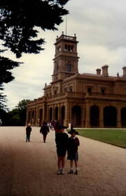
Brothers homes and Andrew Chirnside, who emigrated from Scotland, built the Italianate -style mansion on their Werribee property between 1874 and 1877. They were pioneering pastoralists who foundered the Chirnside Pastoral Empire. The Victorian Government purchased the property in 1973 and it opened as a tourist attraction in 1977 run by Parks Victoria. The photograph was taken when the students from Bulla Primary School visited the property.The visit to Werribee Park Mansion was included in the students' history studies.A coloured non-digital photograph of a large double storey Italianite style mansion with an imposing lookout tower with flagpole over the main entrance. A large sweeping gravel driveway leads to the main entrance.school excursions, bulla primary schooil, werribee park mansion, thomas chirnside, andrew chirnside, parks victoria -
 Wodonga & District Historical Society Inc
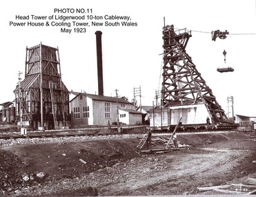
Album - Hume Reservoir Australia Album - Head tower of Lidgerwood, Power House and Cooling Tower May 1923
This set of photos is from a leather bound album bearing the inscription "HUME RESERVOIR AUSTRALIA" plus 'The Rt. Hon. L. C. M. S. Amery, P. C., M .P.' all inscribed in gold. It was presented to The Rt. Hon. L. C. M. S. Amery, P. C., M. P, Secretary of State for Dominion Affairs on the occasion of his visit to the Hume Reservoir on 2nd November 1927. This album is of local and national significance as it documents the planning and development of the Hume Reservoir up to 1927. It was the largest water reservoir in the British Empire. The album records the pioneering engineering work that went into its construction.DEPARTMENT OF PUBLIC WORKS, N.S.W. RIVER MURRAY WATERS SCHEME. HUME RESERVOIR. 11. Head tower of Lidgerwood 10-ton Cableway, Power House and Cooling Tower, New South Wales, May 1923. hume reservoir australia, river murray waters scheme, head tower hume reservoir -
 Wodonga & District Historical Society Inc
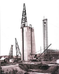
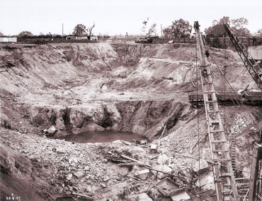
Album - Hume Reservoir Australia Album - Concrete pillar for tall tower, New South Wales, August 1927
This set of photos is from a leather bound album bearing the inscription "HUME RESERVOIR AUSTRALIA" plus 'The Rt. Hon. L. C. M. S. Amery, P. C., M .P.' all inscribed in gold. It was presented to The Rt. Hon. L. C. M. S. Amery, P. C., M. P, Secretary of State for Dominion Affairs on the occasion of his visit to the Hume Reservoir on 2nd November 1927. This album is of local and national significance as it documents the planning and development of the Hume Reservoir up to 1927. It was the largest water reservoir in the British Empire. The album records the pioneering engineering work that went into its construction.DEPARTMENT OF PUBLIC WORKS, N.S.W. RIVER MURRAY WATERS SCHEME. HUME RESERVOIR. 28. Concrete Pillar for Tail Tower. This shows the back and upstream side of the tower. The groove at the back is left for the reception of the concrete core wall of the earth embankment. The groove is being used at present as a hoist well, up and down which men and materials are conveyed in connection with the re-erection of the Tail Tower of the cableway. The pillar is 108 feet from the ground and is within 4 feet of its ultimate height. The foundation of this part at its deepest is 90 feet below the natural surface so that when the 80 feet tower and jury mast are in place the total height from foundation to top of mast will be about 300 feet. New South Wales, August 1927.hume reservoir australia, river murray waters scheme, hume reservoir construction -
 Wodonga & District Historical Society Inc
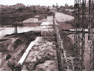
Album - Hume Reservoir Australia Album - View of concrete dam from top of tall tower pillar, August 1927
This set of photos is from a leather bound album bearing the inscription "HUME RESERVOIR AUSTRALIA" plus 'The Rt. Hon. L. C. M. S. Amery, P. C., M .P.' all inscribed in gold. It was presented to The Rt. Hon. L. C. M. S. Amery, P. C., M. P, Secretary of State for Dominion Affairs on the occasion of his visit to the Hume Reservoir on 2nd November 1927. This album is of local and national significance as it documents the planning and development of the Hume Reservoir up to 1927. It was the largest water reservoir in the British Empire. The album records the pioneering engineering work that went into its construction.DEPARTMENT OF PUBLIC WORKS, N.S.W. RIVER MURRAY WATERS SCHEME. HUME RESERVOIR. 29. View from Top of Tail Tower Pillar - Concrete Dam. This was taken from the top of the Tower described in the preceding photograph looking towards New South Wales. (WHS 00722) First is the part of the spillway being built inside the Coffer Dam, then over the Coffer Dam the submerged portion of the Spillway and outlet sections for the river diversion, beyond that the situation for the hydro-electric turbo passages bounded by the North Wing Wall. The gap may be seen in wing wall for the passage of the belt conveyor and half of the concrete mixer house behind. This gives a general view of the New South Wales Township. The Quarry is on the side of the hill showing up beyond the Township. New South Wales, August 1927.hume reservoir australia, river murray waters scheme, hume reservoir construction -
 Wodonga & District Historical Society Inc
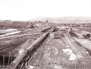
Album - Hume Reservoir Australia Album - View of South Wing Wall Foundations from Top of Tail Tower Pillar, August 1927
This set of photos is from a leather bound album bearing the inscription "HUME RESERVOIR AUSTRALIA" plus 'The Rt. Hon. L. C. M. S. Amery, P. C., M .P.' all inscribed in gold. It was presented to The Rt. Hon. L. C. M. S. Amery, P. C., M. P, Secretary of State for Dominion Affairs on the occasion of his visit to the Hume Reservoir on 2nd November 1927. This album is of local and national significance as it documents the planning and development of the Hume Reservoir up to 1927. It was the largest water reservoir in the British Empire. The album records the pioneering engineering work that went into its construction.DEPARTMENT OF PUBLIC WORKS, N.S.W. RIVER MURRAY WATERS SCHEME. HUME RESERVOIR. 30. View from Top of Tail Tower Pillar - South Wing Wall Foundations. This photograph was taken at right angles to the preceding one, (WHS 00723) ooking downstream along the cut for the South Wing Wall foundation. The granite is at a greater depth here than elsewhere and the cut will be twice as deep before the foundations are cleared. New South Wales. August 1927.hume reservoir australia, river murray waters scheme, hume reservoir construction -
 Wodonga & District Historical Society Inc
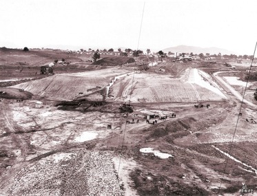
Album - Hume Reservoir Australia Album - Earth embankment on Victorian side from Top of Tail Tower Pillar, August 1927
This set of photos is from a leather bound album bearing the inscription "HUME RESERVOIR AUSTRALIA" plus 'The Rt. Hon. L. C. M. S. Amery, P. C., M .P.' all inscribed in gold. It was presented to The Rt. Hon. L. C. M. S. Amery, P. C., M. P, Secretary of State for Dominion Affairs on the occasion of his visit to the Hume Reservoir on 2nd November 1927. This album is of local and national significance as it documents the planning and development of the Hume Reservoir up to 1927. It was the largest water reservoir in the British Empire. The album records the pioneering engineering work that went into its construction.DEPARTMENT OF PUBLIC WORKS, N.S.W. RIVER MURRAY WATERS SCHEME. HUME RESERVOIR. 31. View from Top of Tail Tower Pillar - Earth Embankment, Victoria. This is a general view of the embankment which is being constructed by the Victorian Constructing Authority. The bank at its base is about 650 feet wide and it is about half its ultimate height. In the middle is the reinforced concrete core wall. At about the natural surface a tunnel for drainage and inspection purposes is built along the downstream side of the core wall but this cannot be seen. The Victorian workshops and township are located on the high ground beyond the embankment. The embankment curves round to the left at the side of the valley and will eventually block the gulley where the bushy tree stands. Access to one of the cuttings from which material is being got for the embankment is gained by means of this gulley at present. Part of another cutting may be seen on the right hand side at the back. August 1927.hume reservoir australia, river murray waters scheme, hume reservoir construction -
 Wodonga & District Historical Society Inc
Album - Hume Reservoir Australia Album - Earth embankment, Victoria, August 1927
This set of photos is from a leather bound album bearing the inscription "HUME RESERVOIR AUSTRALIA" plus 'The Rt. Hon. L. C. M. S. Amery, P. C., M .P.' all inscribed in gold. It was presented to The Rt. Hon. L. C. M. S. Amery, P. C., M. P, Secretary of State for Dominion Affairs on the occasion of his visit to the Hume Reservoir on 2nd November 1927. This album is of local and national significance as it documents the planning and development of the Hume Reservoir up to 1927. It was the largest water reservoir in the British Empire. The album records the pioneering engineering work that went into its construction.DEPARTMENT OF PUBLIC WORKS, N.S.W. RIVER MURRAY WATERS SCHEME. HUME RESERVOIR. 32. Earth Embankment, Victoria. Looking down on the earth embankment and core wall. The earth is conveyed to the bank by rail, tipped out and then put in place by wheeled scoops, the horses and wheels treading and rolling the material into a very compact form while hoses play water on the mass to keep it moist. The concrete pillar with Tail Tower, and North Wing Wall, look very small in the distance. August 1927.hume reservoir australia, river murray waters scheme, hume reservoir construction