Showing 51 items
matching port phillip bay beach
-
 Bayside Gallery - Bayside City Council Art & Heritage Collection
Map, Department of Crown Lands and Survey et al, Moorabbin, County of Bourke, Government Roads, 1920
The cadastral map of the Parish of Moorabbin in Victoria (L.6104) shows parish boundaries and land ownership 1920 when Sandringham was a Town. The government roads have been coloured in red pencil.moorabbin, county of bourke, map, plan, land subdivision, land titles, foreshores, hampton, beaumaris, highett, cheltenham, department of lands and survey, land owners, cartographic material, brighton, sandringham, town of sandringham, government roads -
 Bayside Gallery - Bayside City Council Art & Heritage Collection
Photograph - gelatin silver photograph, Shaw-Ross Aviation Company, Airspy, Middle Brighton, 1935
... Road St Kilda Street Brighton Beach Port Phillip Bay Gelatin ...brighton, middle brighton, aerial, photograph, airspy, shaw-ross aviation company, suburbs, sea baths, pier, dudley street, st ninian's road, st kilda street, brighton beach, port phillip bay -
 Bayside Gallery - Bayside City Council Art & Heritage Collection
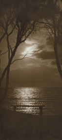
Photograph - sepia photograph, H. Singer, Sunset Brighton Beach, 1919
brighton, beach, sunset, h. singer, photograph, port phillip bay, ti-tree -
 Bayside Gallery - Bayside City Council Art & Heritage Collection
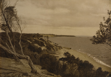
Photograph - sepia photograph, Sandringham
... Sandringham Beach Coast red bluff Port Phillip Bay Ti-tree sepia ...sandringham, beach, coast, red bluff, port phillip bay, ti-tree -
 Bayside Gallery - Bayside City Council Art & Heritage Collection
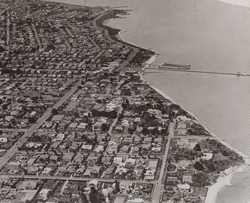
Photograph, Department of Crown Lands and Survey, Victoria, Melbourne Project: Brighton, Hampton, Sandringham, 1976
The Department of Crown Lands and Survey (1857-1983) was responsible for the administration of survey and mapping and the sale, occupation and management of crown land throughout its existence. This aerial photograph shows parts of Brighton, Hampton and Sandringham and was taken on 1 December 1976brighton, department of crown lands and survey, aerial photograph, bayside, port phillip bay, map, cartographic material, hampton, sandringham, green point, sandringham yacht club, south road, beach road, hampton street, melbourne project 1976 -
 Bayside Gallery - Bayside City Council Art & Heritage Collection
Photograph, Department of Crown Lands and Survey, Victoria, Melbourne Project: Brighton and Hampton, 1976
The Department of Crown Lands and Survey (1857-1983) was responsible for the administration of survey and mapping and the sale, occupation and management of crown land throughout its existence. This aerial photograph shows parts of Brighton and Hampton and was taken on 1 December 1976. brighton, department of crown lands and survey, aerial photograph, bayside, port phillip bay, map, cartographic material, melbourne project 1976, brighton yacht club, middle brighton baths, hampton, green point, brighton beach, south road, the esplanade, hampton street -
 Bayside Gallery - Bayside City Council Art & Heritage Collection
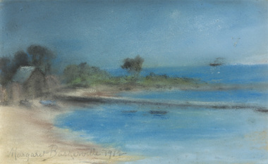
Work on paper - pastel, Margaret Baskerville, Bathing box by beach, 1912
pastelbeach, coast, bathing box, margaret baskerville, bayside, port phillip bay, jetty, ship, bush -
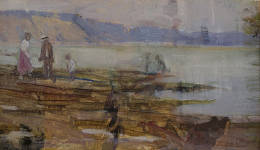 Bayside Gallery - Bayside City Council Art & Heritage Collection
Painting - oil on canvas, Jessie Constance Alicia Traill, Beach scene, early 20th century
This work depicts the coast at Black Rock. Figures in early 20th century outfits are dotted on the oxide rocky outcrops in the foreground and beyond the water the hazy Red Bluff cliff dominates the coast.Impressionismoil on canvasbeach, coast, figures, jessie traill, red bluff, bayside, black rock, bathers, port phillip bay, bay, water -
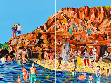 Bayside Gallery - Bayside City Council Art & Heritage Collection
Painting - oil on linen, Rob McHaffie, Word of mouth (Half Moon Bay), 2018
Word of mouth (Half Moon Bay) 2018 is a two-panel work which is the largest painting the artist has made to date. It is a colourful and fun, light-hearted scene of an imaginative party that the artist would love to attend at Half Moon Bay in Black Rock. Depicted in the work are over 30 figures, including international tourists, family and friends of McHaffie as well as famous identities such as musicians David Bowie and Solange Knowles, and fashion designer Karl Lagerfeld. McHaffie’s DJ friend Lucreccia Quintanilla has set up a DJ deck and speakers on the beach while the party goers are wading in the shallow waters, dancing on the cliff and mingling on the beach in what appears to be an idyllic summer’s day in Bayside.oil on linen (diptych)painting, beach, half moon bay, black rock, bayside, coast, party, rob mchaffie, dj, dance, musician, karl lagerfeld, david bowie, solange knowles, lucreccia quintanilla, port phillip bay, word of mouth, mooji, jon campbell, tourists, family, friends, cliff, rocks, water -
 Bayside Gallery - Bayside City Council Art & Heritage Collection
Map, Department of Crown Lands and Survey, Moorabbin, County of Bourke, c. 1918
The cadastral map of the Parish of Moorabbin in Victoria (L.6104) shows parish boundaries and land ownership c. 1918 when Sandringham was a Borough.moorabbin, county of bourke, map, plan, land subdivision, land titles, foreshores, sndringham, hampton, beaumaris, highett, cheltenham, department of lands and survey, land owners, cartographic material, borough of sandringham, brighton -
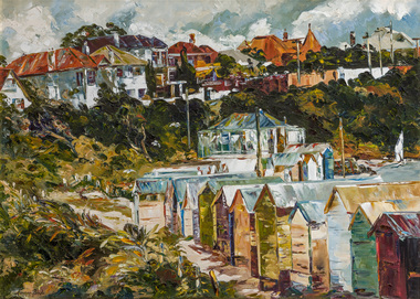 Bayside Gallery - Bayside City Council Art & Heritage Collection
Painting - oil on canvas, Margery Boyle, Bathing Boxes, Brighton, c. 1978
... beach coast Port Phillip Bay Margery Boyle Bathing Boxes ...bathing box, bathing shed, bathing boxes, brighton, brighton beach, beach, coast, port phillip bay, margery boyle -
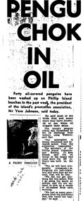 Phillip Island Conservation Society Inc.
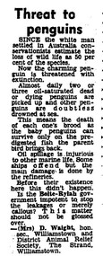
Work on paper - Photocopy of newspaper cutting, "PENGU/ CHOK/ IN/ OIL" (meant to be : "Penguins choke in oil"
With the establishment of the large heavy industrial zone at Hastings in the late 1960s, which included the BP oil refinery using the Port of Hastings at the north-western arm of Western Port, a number of environmental problems predicted by both scientists and conservationists arose. The main shipping channel on the western arm of Western Port was dredged, causing suspended particles affecting seagrass beds. With inadequate regulation around discharge of bilge water within the bay, and oil spillage, oil pollution affecting both seabirds and coastal areas was not uncommon. This report of 40 penguins actually known to have been killed by an oil spill event was typical of reports at the time. The 2 men quoted – Vernon Johnson and Ken Pound – were well known conservationists. Vernon and his wife Nora owned the Kingston Gardens picnic and zoo business where they cared for many injured wildlife. Ken was a Phillip Island counsellor for a few years, and instrumental in the establishment of the Phillip Island conservation Society. He also contributed various documents and newspaper cuttings to this archive.This article is significant for being a record of an exact number of penguins found dead from oil spill pollution in Western Port. Also as a record of conservationists in the early years of community and environment movements both locally and in Australia. The article further gives evidence of linking tourism with wildlife.Photocopy of newspaper cutting. Black print with very dark black and white photo of Fairy (Little) Penguin. Poor reproduction due to older photocopy machine.(indecipherable) - late/1960s.little penguins, fairy penguins, eudyptula minor, penguin behaviour, phillip island tourist attractions, phillip island conservation society, oil spills, bp refinery hastings, port of hastings, western port, marine pollution, oil tankers, vernon johnson, ken pound, phillip island promotion association -
 Phillip Island Conservation Society Inc.
Work on paper - photocopy of letter to editor newspaper cutting, "Threat to/ Penguins"
This letter to the editor of an unknown newspaper probably dates from the late 1960s or early 1970s. At that time the Victorian government’s Liberal Party Premier was Sir Henry Bolte. In a reference to the major industrial valley in Germany, he and his government had a vision to make Western Port and Hastings into “the Ruhr of Victoria”, if not Australia. While this letter does not refer to Western Port, but apparently to Wiliamstown, the situation was similar in both bays. Substantial land was zoned in Hastings by the Bolte Government for industrial purposes, where BP built a refinery for oil imported through the Port of Hastings. The large oil tankers entered Western Port Bay via the western channel, which required dredging to accommodate them. It became a common site to see globules or patches of oil washed up on beaches around Western Port, and oil-affected wildlife. It is impossible to know how many wildlife were affected directly by oil spills and other forms of pollution in the Bay during that era. Sufficient numbers of oiled Little Penguins were found to prompt numerous references to the problem in newspapers, including letters, articles and even major features. The refinery eventually closed, with tanker traffic dramatically reducing in Western Port from the late 20th century.Statement of significance: This letter to the editor is significant in making reference to pollution caused in Port Phillip and Western Port bays by tanker traffic and the presence of oil refineries on industrial land in the bays. It is also indicative of the emergence of many conservation-related community groups of volunteers in Australia during the 1960s and 1970s in response to growing concern around conservation issues. Letters to the editor were a common means for these groups to have their concerns aired in public.Photocopy of newspaper cutting, single column letter to the editor.little penguins, oil spill, western port, port of hastings, henry bolte, "ruhr of victoria", oiled penguins, oiled wildlife, bp refinery, oil tankers, , mrs d waight, williamstown and district animal relief society -
 City of Kingston
Photograph - Colour, c. 1993
Patterson Lakes is a suburb in the City of Kingston that is built one kilometre upstream of the mouth of the Patterson River. The area is bordered by the Patterson River and Eel Race Drain which enters the Kananook Creek. The suburb consists predominantly of newer housing developments and the tidal canal system of the development joins Port Phillip Bay.Patterson Lakes and the Kananook Creek were previously part of the extensive Carrum Carrum Swamp. The area was once a source of fish and eels for the Mayone-Bulluk clan of the Bunurong people. Over time the area was drained and in 1973 investigations commenced into the development of a unique residential area that would be built adjacent to canals and waterways. It was originally proposed to be known as "Gladesville". The development would give the suburb's homeowners access to Port Phillip Bay "from their back door". Circa 1974, the area was rezoned from rural to residential and named Patterson Lakes. Development has been continuous since the 1970s with construction of residential housing, schools, shopping centres, marinas, a hotel and library.Laminated colour aerial photograph of the Carrum and Patterson Lakes region within City of Kingston. This 1993 image includes Patterson River Secondary College, Roy Dore Reserve, Kananook Creek and Nepean Highway. The railway line can be seen as it veers inland from Eel Race Road, Seaford. The section of Palm Beach Drive, Curlew Point Drive, Snapper Point Drive, Clipper Island and Myola Street in Patterson Lakes appears to be a recent development with many spare blocks and new houses under construction.patterson lakes, seaford, kananook creek, carrum carrum swamp, canals and waterways -
City of Kingston
Photograph - Colour, 6 March 1993
Edithvale is a suburb in the City of Kingston. It is located between Aspendale and Chelsea on the Port Phillip Bay and built within remnant areas of the Carrum Carrum swamp. The foreshore precinct comprises a wide sandy beach, with low sand dunes and numerous historic boat sheds. The suburb consists of older style dwellings and former holiday houses, combined with mid-century housing and newer homes. The large blocks are increasingly subdivided and the existing dwellings demolished to accommodate units and townhouses, thus changing the landscape of the area and reducing the tree canopy.The beachside suburb of Edithvale was previously part of the extensive Carrum Carrum Swamp. The area was once a source of fish and eels for the Mayone-Bulluk clan of the Bunurong people. Over time the area was drained and predominantly devoted to dairy farming and holiday houses. The farms were gradually sold and subdivided with a large number of homes built after World War II and in the 1960s. Edithvale is mainly residential with a shopping strip along Nepean Highway but little significant industry was ever established in the area apart from a plaster works and confectionary factory, both now closed.Laminated aerial colour photograph of Edithvale as viewed from Alexandra Avenue in the north to Ella Grove Chelsea/Edithvale in the south. regents Park Aspendale can be seen in the top left. The area is built-up with residential housing and facilities including Edithvale Primary School, numerous churches and the Edithvale Railway station. Large sections depict the remnant Carrum Carrum swamp. Edithvale Common and the former "Duck Inn" (Melbourne Water/Friends of Edithvale Seaford Wetlands) can be seen. Edithvale Recreational reserve, the valodrome and Edithvale Public Golf Course are prominent. The image shows vacant land in the area now known as Aspendale Gardens and the newer residential section of Chelsea Heights is not developed. A bike path has been established to cover the secondary drain. The Golf Links Court residential development located off Hughes Avenue is a large vacant block.Black type on white adhesive label: 6-3-93 Black type on white adhesive label: 25/9211, 6/3/93, 11.20 am Black type on white adhesive label: 9211 Yellow circular adhesive sticker Black pencil: 9211 6-3-93 arrow pointing Nedthvale, carrum carrum swamp, aspendale, chelsea -
 Lakes Entrance Historical Society
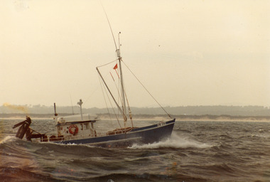
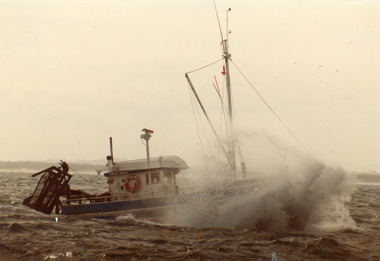
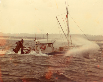
Photograph - Moya Ann, 1980c
'Moya Anne' from Port Phillip Bay 1980'sColour photograph of scallop fishing boat Moya Ann, beginning its entry into port. Sandy beach of coastline in distance. Photograph appears to have been taken from another vessel. Lakes Entrance Victoriafishing industry, ships and shipping -
 Lakes Entrance Historical Society
Photograph - Moya Ann, 1980c
'Moya Anne' from Port Phillip Bay 1980'sColour photograph of scallop fishing boat Moya Ann, beginning its entry into port. Sandy beach of coastline in distance. Photograph appears to have been taken from another vessel. Lakes Entrance Victoriafishing industry, ships and shipping -
City of Kingston
Photograph - Colour, Circa 1993
Edithvale is a suburb in the City of Kingston. It is located between Aspendale and Chelsea on the Port Phillip Bay and built within remnant areas of the Carrum Carrum swamp. The foreshore precinct comprises a wide sandy beach, with low sand dunes and numerous historic boat sheds. The suburb consists of older style dwellings and former holiday houses, combined with mid-century housing and newer homes. The large blocks are increasingly subdivided and the existing dwellings demolished to accommodate units and townhouses, thus changing the landscape of the area and reducing the tree canopy.The beachside suburb of Edithvale was previously part of the extensive Carrum Carrum Swamp. The area was once a source of fish and eels for the Mayone-Bulluk clan of the Bunurong people. Over time the area was drained and predominantly devoted to dairy farming and holiday houses. The farms were gradually sold and subdivided with a large number of homes built after World War II and in the 1960s. Edithvale is mainly residential with a shopping strip along Nepean Highway but little significant industry was ever established in the area apart from a plaster works and confectionary factory, both now closed.Aerial colour photograph of Edithvale as viewed from Alexandra Avenue in the north to Ella Grove Chelsea/Edithvale in the south. The area is built-up with residential housing and facilities including Edithvale Primary School, numerous churches and the Edithvale Railway station. Large sections depict the remnant Carrum Carrum swamp. Edithvale Common and the former "Duck Inn" (Melbourne Water/Friends of Edithvale Seaford Wetlands) can be seen. Edithvale Recreational reserve, the velodrome and Edithvale Public Golf Course are prominent. The image shows vacant land in the area now known as Aspendale Gardens and the newer residential section of Chelsea Heights is not developed. A bike path has been established to cover the secondary drain. The Golf Links Court residential development located off Hughes Avenue is a large vacant block.Yellow circular adhesive sticker on plastic Black ink (marker): * (asterisk) Black type on white adhesive sticker: P000108edithvale, aspendale, chelsea, carrum carrum swamp -
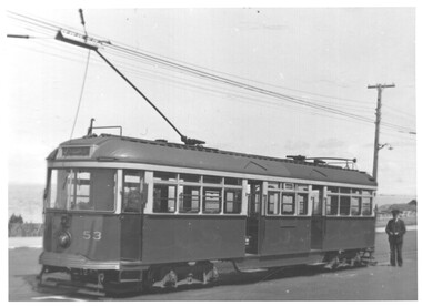 Melbourne Tram Museum
Photograph - VR Tram 53 at Brighton Beach
... with Port Phillip bay in the background. Has the driver standing... with Port Phillip bay in the background. Has the driver standing ...Photo of VR tram No. 53 at the Brighton Beach terminus with Port Phillip bay in the background. Has the driver standing by the front of the tram. Date and photographer unknown.Yields information about VR tram No. 53 at Brighton Beach.Black and white photograph with a stamp on the rear.Has the Ken Magor stamp and number "2160" written in.tramcars, tramways, vr, brighton beach, tram 53 -
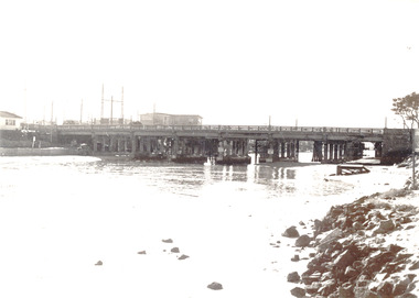 Chelsea & District Historical Society Inc
Photograph - Patterson River, Rail and Road Bridge, Carrum
The first bridge over the river was built in the early 1880's, prior to this it was a pontoon bridge. In 1927 a concrete bridge was built to replace the wooden bridge.Black and white photo of Patterson River, looking east from the Port Phillip Bay. PATTERSON RRIVER BRIDGE, CARRUMpatterson river, chelsea, patterson river bridge, carrum bridge, canoes, beach, leisure