Showing 1046 items
matching shire services
-
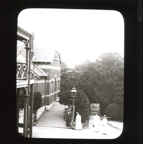 The Beechworth Burke Museum
Photograph - Lantern Slide, c1900
This image appears to show nurses at what is now the Mayday Hills Mental Asylum arriving for work in approximately 1900. These individuals are part of a long history of nursing in Beechworth. Three medical or social welfare facilities opened in the mid-1800s as part of a push by the township to become a regional centre for Government services. These were the Ovens District Hospital (opened in 1857), the Ovens Benevolent Asylum (opened in 1863), and the Beechworth Mental Hospital (opened in 1867 and renamed Mayday Hills Hospital at Centenary celebrations in 1967). It was recognised that the unsettled living conditions, poverty and relative isolation of the Goldfields environment could produce 'mental disturbances' which required local treatment facilities as services in Melbourne were too far away. Carole Woods' publication 'A Titan's Field' describes activities undertaken by patients at Beechworth Mental Hospital as including monthly balls and occasional concerts as well as work to make the facility self-supporting such as farm work and making clothes. She mentions a report in 1870 that the approximately 300 patients were clean and neat with 'no-one in restraint or seclusion' but that by 1905 the organisation had 623 patients which placed strain on building infrastructure such as heating and water supplies, leading to high turnover of nurses and other issues. A program of building works to extend and improve facilities followed over subsequent decades. Lantern slides, sometimes called 'magic lantern' slides, are glass plates on which an image has been secured for the purpose of projection. Glass slides were etched or hand-painted for this purpose from the Eighteenth Century but the process became more popular and accessible to the public with the development of photographic-emulsion slides used with a 'Magic Lantern' device in the mid-Nineteenth Century. Photographic lantern slides comprise a double-negative emulsion layer (forming a positive image) between thin glass plates that are bound together. A number of processes existed to form and bind the emulsion layer to the base plate, including the albumen, wet plate collodion, gelatine dry plate and Woodburytype techniques. Lantern slides and magic lantern technologies are seen as foundational precursors to the development of modern photography and film-making techniques This glass slide is significant because it provides insight into Beechworth's social and medical amenities in the early Twentieth Century, around the time of Australia's Federation into one nation. It is also an example of an early photographic and film-making technology in use in regional Victoria in the time period.Thin translucent sheet of glass with a rectangular image printed on the front and framed in a black backing. It is held together by metals strips to secure the edges of the slide.Obverse: i /burke museum, beechworth, lantern slide, slide, glass slide, plate, burke museum collection, photograph, monochrome, magic lantern, indigo shire, north-east victoria, nineteenth century, 1900s, twentieth century, emulsion slides, nursing, nurses, mental hospitals, lunatic asylums, asylums, social services, social welfare, insane asylums, mental health, infrastructure -
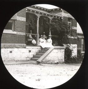 The Beechworth Burke Museum
Photograph - Lantern Slide, c1900
This image appears to show nurses at what is now the Mayday Hills Mental Asylum in approximately 1900. These individuals are part of a long history of nursing in Beechworth. Three medical or social welfare facilities opened in the mid-1800s as part of a push by the township to become a regional centre for Government services. These were the Ovens District Hospital (opened in 1857), the Ovens Benevolent Asylum (opened in 1863), and the Beechworth Mental Hospital (opened in 1867 and renamed Mayday Hills Hospital at Centenary celebrations in 1967). It was recognised that the unsettled living conditions, poverty and relative isolation of the Goldfields environment could produce 'mental disturbances' which required local treatment facilities as services in Melbourne were too far away. Carole Woods' publication 'A Titan's Field' describes activities undertaken by patients at Beechworth Mental Hospital as including monthly balls and occasional concerts as well as work to make the facility self-supporting such as farm work and making clothes. She mentions a report in 1870 that the approximately 300 patients were clean and neat with 'no-one in restraint or seclusion' but that by 1905 the organisation had 623 patients which placed strain on building infrastructure such as heating and water supplies, leading to high turnover of nurses and other issues. A program of building works to extend and improve facilities followed over subsequent decades. Lantern slides, sometimes called 'magic lantern' slides, are glass plates on which an image has been secured for the purpose of projection. Glass slides were etched or hand-painted for this purpose from the Eighteenth Century but the process became more popular and accessible to the public with the development of photographic-emulsion slides used with a 'Magic Lantern' device in the mid-Nineteenth Century. Photographic lantern slides comprise a double-negative emulsion layer (forming a positive image) between thin glass plates that are bound together. A number of processes existed to form and bind the emulsion layer to the base plate, including the albumen, wet plate collodion, gelatine dry plate and Woodburytype techniques. Lantern slides and magic lantern technologies are seen as foundational precursors to the development of modern photography and film-making techniques.This glass slide is significant because it provides insight into Beechworth's social and medical amenities in the early Twentieth Century, around the time of Australia's Federation into one nation. It is also an example of an early photographic and film-making technology in use in regional Victoria in the time period.Thin translucent sheet of glass with a circular image printed on the front and framed in a black backing. It is held together by metals strips to secure the edges of the slide.burke museum, beechworth, lantern slide, slide, glass slide, plate, burke museum collection, photograph, monochrome, magic lantern, indigo shire, north-east victoria, nineteenth century, 1900s, twentieth century, emulsion slides, nursing, nurses, mental hospitals, lunatic asylums, asylums, social services, social welfare, insane asylums, mental health, infrastructure -
 Orbost & District Historical Society
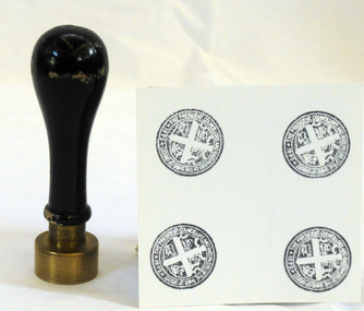
Council Seal
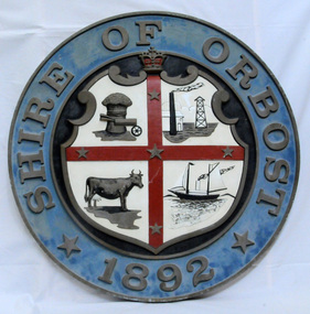
This item was used as a seal (stamp) on official Shire Council documents. The coat of arms of the Shire of Orbost was designed in the form of a cross in which five stars are depicted on a shield. A small crown above the cross indicates the loyalty of the president,councillors and ratepayers to the reigning monarch. The inner section of the shield contains 4 figures, a sheaf of wheat, a factory, a co and a ship - all representing the activities of agriculture, fishing,industry and dairying undertaken in the shire. Originally part of the Bairnsdale district, Orbost split away as part of the Tambo Shire in 1882, and became a shire in its own right as the Shire of Croajingolong on 30th May,1892. The name was changed to the Shire of Orbost on 17th February, 1893. The Orbost Shire Council was abolished on 2nd December, 1994 as part of a state-wide program of local government reform to become part of the newly constituted East Gippsland Shire council.Local governments play an important role in the lives of citizens in Australia. Local government authorities exist to provide services and amenities to local communities, and are also responsible for regulating and providing services for land and property in their district. This item is representative of a time when Orbost had its own Shire Council.The former Orbost Shire Council Seal (stamp) depicting the coat of arms. The circular seal is brass and has a wooden handle with a bulb shaped top.President, Councillors and Ratepayers of the Shire of Orbost-1892orbost orbost-shire-council government history seal -
 Orbost & District Historical Society
jumper, 1970's -1980's
This jumper was worn by John Court as an employee of Orbost Shire Council. Orbost was at first included in the Bairnsdale Shire from 1882 and was later part of the Tambo Shire. Because of travelling distances the Croajingalong Shire was created in 1892 (name changed to Orbost Shire 17.2.1893 with James Cameron as the first Shire President. In 1994 it amalgamated to become part of East Gippsland Shire Council.Local governments play an important role in the lives of citizens in Australia. Local government authorities exist to provide services and amenities to local communities, and are also responsible for regulating and providing services for land and property in their district. This item is representative of a time when Orbost had its own Shire Council.A fawn coloured V - necked long-sleeved woollen jumper. It has a waratah emblem embroidered in red with green leaves. Below this is embroidered the word ORBOST in gold.uniform jumper orbost-shire-council court-john -
 Orbost & District Historical Society
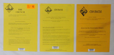
newsletters, The Crunch, 1995 1996
These newsletters were created as an ACCESS project at the Orbost centre of TAFE (Technical and Further Education). Community newsletters are published by local groups and provide community news and information. In small rural communities they are an important communication medium.Three issues of a newsletter titled The Crunch. This was a newsletter for the Orbost community and contains articles on Orbost events. Most articles refer to TAFE Outreach Services. 2407.1 and 2407.2 are printed on yellow paper. 2407.3 has 3 orange sheets and 2 yellow sheets. All are stapled. 2407.1 has a label on the front with East Gippsland Shire Library and a bar code. 2407.2 has a bar code and LOCAL Newsletter written in pencil. 2407.3 has a stamp - EAST GIPPSLAND LIBRARY SERVICE and LOCAL written in pencil.newsletters tafe-orbost -
 Orbost & District Historical Society
Invitation, 1969
The current building was opened on Friday 28th February 1969 by the Premier of Victoria, The Hon. Sir Henry E. Bolte, K.C.M.G., M.P. The Shire of Orbost was a local government area about 380 kilometres east of Melbourne, the state capital of Victoria, Australia. The shire covered an area of 9,347 square kilometres and existed from 1892 until 1994. Originally, Orbost was part of the Bairnsdale Road District which was created on 30 April 1867. Splitting away as part of the Shire of Tambo in 1882, Orbost was first incorporated as a shire in its own right as the Shire of Croajingolong on 30 May 1892. It received its present name on 17 February 1893. On 3 January 1913 part of its western riding was annexed to Tambo as its Cunninghame Riding. Local governments play an important role in the lives of citizens in Australia. Local government authorities exist to provide services and amenities to local communities, and are also responsible for regulating and providing services for land and property in their district. This item is representative of a time when Orbost had its own Shire Council. A stapled program and invitation to the official opening of the new Orbost Shire Council Municipal Offices. A light blue card with the Orbost Shire Council insignia and gold print on front. The invitation is addressed to the secretary of Orbost Historical Society Judith Walcott.handwritten in blue pen - "Judith G Walcott"orbost-shire-council -
 Orbost & District Historical Society
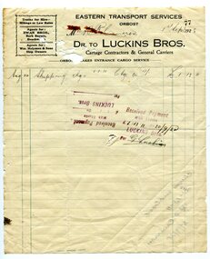
account, 1st September 1928
Robert Pullar Cameron was a Shire Councillor for many years. He married Penuel Hossack and had a family of James, Flora, Penuel and Alex.This document is an example of early book keeping records and is a useful research tool.A white paper account with black print and green lines for Luckin Bros, Cartage Conbtractors & General Carriers to R. Cameron. It is headed "Eastern Transport Services".on back left hand corner -"Cheque Corner......."luckins-bros-general-carriers account cameron-robert-pullar -
 Orbost & District Historical Society
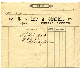
receipt docket, November 30, 1910
Mr Fred Lay, along with his father and brothers, owned the local carrier business with Mr Charlie Joiner as a business partner. They used a horse and cart to transport goods from the railway station into Orbost . In about 1907-08 Mr. Charles Joiner and Mr. Alf Lay came together and conducted a regular service — Mr. Lay at Lakes with a five horse team (because he had to travel the beach at Lake Tyers) and Mr. Joiner, at Orbost, with four horses. The two met half way and changed wagons. Asked why they did this it was said they met every boat and were at the jetty every day. This was why they cornered most of the inward loadings. (ref. River Trading on the Snowy, John Phillips) Later the business was sold to Mr David Williams. Robert Pullar Cameron was a Shire Councillor for many years. He married Penuel Hossack and had a family of James, Flora, Penuel and Alex.This item is an example of a book keeping document used by an early Orbost Business. It is a useful research item.A white receipt docket with black lines and print from Lay & Joiner, General Carriers to R. Cameron.on front - "Paid by Cash"cameron-robert-pullar lay-&-joiner-carriers transport document-receipt -
 Orbost & District Historical Society
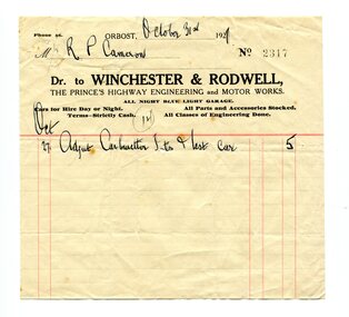
account, October 31st 1921
Winchester & Rodwell was an engineering and motor works opposite the Commonwealth Hotel in Orbost. It was the service station for General Motors products as well as the official R.A.C.V. service station. Robert Pullar Cameron was a Shire Councillor for many years. He married Penuel Hossack and had a family of James, Flora, Penuel and Alex.This item is an example of the book-keeping of an Orbost business in the early 20th century. It is a useful research tool.A white paper account with black print and red lines.It is from Winchester & Rodwell, Engineering & Motor Works to R.P. Cameron.account-book-keeping winchester-rodwell cameron,r.p. -
 Orbost & District Historical Society
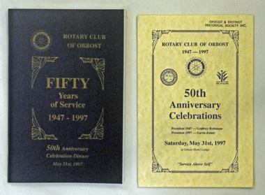
books and pamphlets, Rotary Club 50 Years, 1997
The book and program were produced as part of the 50 year celebrations of Orbost Rotary Club. This is locally written history book which is a useful research tool.Two dark blue covered books with 124 pp. There is gold lettering on the front cover ; ROTARY CLUB OF ORBOST FIFTY YEARS OF SERVICE 1947-1997 50th Anniversary Celebrations. In the top left corner is the Rotary International symbol. The book title has gold corner frames. Two yellow single page programs for the celebratory dinner held at Orbost Motel Lodge on 31/5/1997. It has the Rotary International symbol. the East Gippsland Shire logo and an early Orbost Shire coat of arms. 2192.1 - has autographs /signatures in the back 2192.2 - Ruth Leggerotary-orbost -
 Orbost & District Historical Society
plaque
The Coat of Arms of the Shire of Orbost has been designed in the form of a cross in which five stars are set on a shield. This was typical of those used by many shires and cities throughout Victoria and the Commonwealth. A small crown above the cross indicates the loyalty of the President, Councillors and Ratepayers to the reigning King or Queen. The inner circle of the shield contains four figures, a sheaf of wheat, a factory, a cow, and a ship, which represents the activities of agriculture, fishing, industry and dairying undertaken in the district. Originally part of the Bairnsdale district, Orbost split away as part of the Shire of Tambo in 1882, and became a Shire in its own right as the Shire of Croajingolong on the 30th may 1892. The name changed to the Shire of Orbost on 17 February 1893. Orbost was divided into four ridings on 31st May 1895, they were the North, South, East and Central riding, which was represented by three elected councillors. The Shire coat of arms was on the wall on the right of the front entrance to the building and was removed from the current building when Orbost Shire Council was amalgamated into East Gippsland Shire in 1994.The current building was opened on Friday 28th February 1969 by the Premier of Victoria, The Hon. Sir Henry E. Bolte, K.C.M.G., M.P. Local governments play an important role in the lives of citizens in Australia. Local government authorities exist to provide services and amenities to local communities, and are also responsible for regulating and providing services for land and property in their district. This item is representative of a time when Orbost had its own Shire Council. A large round metal plaque with the words SHIRE OF ORBOST1892 in gold letters around a crown and shield divided into four sections to represent four industries : Shipping ; farming - maize ; dairy and mining.SHIRE OF ORBOST 1892government orbost-shire-council coat-of-arms plaque -
 The Beechworth Burke Museum
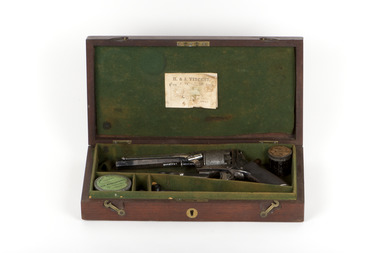
Weapon - Tranter Revolver, Robert O'Hara Burke's Revolver
This gun was presented to Robert O’Hara Burke Esq in 1858 by the Beechworth Police in recognition of his four years’ service as the Police Superintendent at Beechworth. It arrived back in Beechworth on Thursday 10th April, 2014.Presented to R. O’Hara Burke Esq / Supt. of Police by the Officers of the district on his transfer from Beechworth / November 1858 /burke, robert o'hara burke, burke museum, robert o'hara burke museum, firearm, burke and wills, burke & wills, burke and wills expedition, expedition, beechworth, indigo shire, north-east victoria, revolver -
 The Beechworth Burke Museum
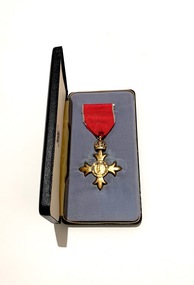
Medal - Order of the British Empire Medal, 01/01/1976
David Aloysius Patrick McKenzie-McHarg, L.I.B, O.B.E was born on 20th June 1918 in Albury, NSW to Hugh Patrick McKenzie-McHarg and Laura May (Dunne) McKenzie-McHarg. McKenzie-McHarg served on the Council of the United Shire of Beechworth for more than a decade during the 1960s-70s, including seven years as president. He was renowned as a public speaker and played a significant role in the community. In recognition for his outstanding achievements and services rendered to the Beechworth community he was awarded an Order of the British Empire (OBE) in 1976. David McKenzie-McHarg died on 6th June 1992 and is buried in Beechworth Cemetery. David McKenzie-McHarg’s wife, Marjorie Jean McKenzie McHarg, was well known to the Beechworth community as a brilliant pianist and played at all the balls and house parties. Apparently, she could play without sheet-music and would only have to hear a tune once to play it to near perfection. Together, they were a formidable asset to the Beechworth community over many years The British honours system has various orders, usually relating to the monarchy, military and colonial officials. An OBE (or order of the British Empire) is given for an outstanding achievement or service to the community. This will have had a long-term, significant impact and stand out as an example to others. This Order was established by George V in 1917 in response to recognising the thousands of men and women who served in a variety of non-combatant roles during the First world war who didn’t otherwise receive any formal recognition but were certainly worthy of acknowledgement. Recommendations for appointments to this Order were originally made on the nomination of the United Kingdom, however this soon became available to Commonwealth countries as well. However, Australia officially ceased to recommend the Order of the British Empire in 1989 with the establishment of the Order of Australia. Silver badge suspended from red ribbon with pearl-grey edges. The badge is in the form of a cross patonce (having the arms growing broader and floriated toward the end), the obverse of which bears the same field as the star pictures George V and Queen Mary. The reverse bears George V's Royal and Imperial Cypher. Both are within a ring bearing the motto of the Order: FOR GOD AND THE EMPIRE. The presentation case in which the medal is housed is of a black outer boarder edge leatherette finishing, block letters in gold OBE. The inside has a cream velvet base with a silk padded liner to the roof with the full set of Royal Mint Crest Mark. Obverse: FOR GOD AND THE EMPIRE / burke museum, obe, obe medal, beechworth, david mckenzie-mcharg, british honours system, george v, beechworth community, order of australia., order of the british empire, marjorie jean mckenzie mcharg -
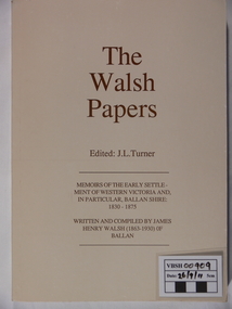 Ballan Shire Historical Society
Book - Book. The Walsh Papers, The Walsh Papers, 1985
The former Shire of Ballan commissioned this work which ties in with the formation and early years of the Ballan Shire Historical Society. It is a collection of articles, works and memoirs written and compiled by James Henry Walsh, an early resident of Ballan, that have been edited for publication by James Turner. The book contains maps and photographs and is fully indexed. It is considered by some to be the foremost reference work on the history of Ballan.The book is significant as it is a comprehensive collection covering the history of Ballan. It is a limited edition and now out of print.A soft covered book, ivory in colour. Printed on the cover is - "The Walsh Papers. Edited: J.L.Turner. Memoirs of the early settlement of Western Victoria and, in particular, Ballan Shire: 1830 -1875. Written and compiled by James Henry Walsh (1863 -1930) of Ballan." The back cover is a full page sepia photograph of James Walsh (head and shoulders only) and the printed number "ISBN 0 95599911 1 5". Book No.106. 312 pages.The book bears the stamp of the Ballan Shire Historical Society and the handwritten marking "Receipt P.1." Book No.106 and Reg No. (VC) 00909 in pencil.walsh james henry, ballan memoirs, turner j l, ballan history -
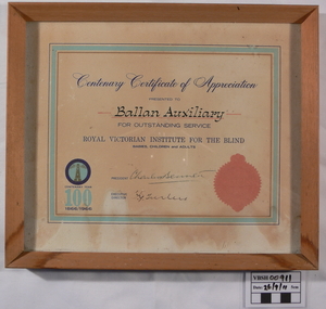 Ballan Shire Historical Society
Certificate - Certificate. RVIB
A Centenary Certificate of Appreciation presented by the RVIB to the Ballan Auxiliary for outstanding service.A Centenary Certificate of Appreciation presented to Ballan Auxiliary for outstanding service. Royal Victorian Institute for the Blind, babies, children and adults. It bears the RVIB Seal, a logo and the words Centenary Year 100 1866/1966. It is signed by the President and the Executive Director. The certificate is cream coloured with a light blue border, under glass in a plain, beveled, light coloured timber frame.This registration number is marked on the back of the frame.certificate, royal victorian institute for the blind, ballan auxiliary -
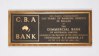 Ballan Shire Historical Society
Plaque - C. B. A. Bank commemorative plaque, Arrow Engraving Pty. Ltd., Melbourne, Commercial Bank of Australia Limited, 1967
This plaque commemorates 100 years of banking service in Ballan by the Commercial Bank of Australia Limited. Unveiled by the President of the Shire of Ballan, Councillor K. D. Andrew J. P. on the 11th day of April 1967.A bronze engraved plaque mounted on a timber baseAs in the photographballan shire, commercial bank, andrew k.d. -
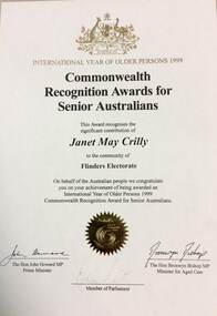 Phillip Island and District Historical Society Inc.
Certificate - Certificates, Volunteer Award Certificates Janet Crilly, 1990s
Janet was a long standing member of Phillip Island Red Cross Branch, being awarded a 30 year service awardA framed award certificate, 4 photocopied volunteer award certificates, 1 letter and 5 photocopied articles from the AdvertiserInternational Year of Older Persons 1999 Commonwealth Recognition Award for Senior Australians, awarded to Janet May Crilly for the Flinders Electorate. Shire of Phillip Island Volunteer Service awards for invaluable service as a volunteer to the community of Phillip Island for 1992, 1994, 1995 Photos and articles of Red Cross volunteers and long service awards, approximately mid 1990sjanet crilly, red cross, trophies & awards -
 Phillip Island and District Historical Society Inc.
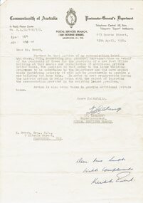
Document, Application for new Post Office, 1954-55
HistoricalTwo typed letters on cream writing paper and copy paper. One from Superintendent of Postal Services to K.Ewert, M.P. and one from Shire Secretary to P M G Department re urgent need for a new post office. Also envelope with letter.post office, postal services -
 Orbost & District Historical Society
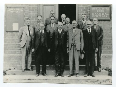
black / white photograph, first half 20th century
This is a photograph of some of the Orbost Shire councillors standing outside their council chambers. This photograph was taken before 1969 outside the previous council offices in Orbost. The current building was opened on Friday 28th February 1969 by the Premier of Victoria, The Hon. Sir Henry E. Bolte, K.C.M.G., M.P. The Shire of Orbost was a local government area about 380 kilometres east of Melbourne, the state capital of Victoria, Australia. The shire covered an area of 9,347 square kilometres and existed from 1892 until 1994. Originally, Orbost was part of the Bairnsdale Road District which was created on 30 April 1867. Splitting away as part of the Shire of Tambo in 1882, Orbost was first incorporated as a shire in its own right as the Shire of Croajingolong on 30 May 1892. It received its present name on 17 February 1893. On 3 January 1913 part of its western riding was annexed to Tambo as its Cunninghame Riding. Local governments play an important role in the lives of citizens in Australia. Local government authorities exist to provide services and amenities to local communities, and are also responsible for regulating and providing services for land and property in their district. This item is representative of a time when Orbost had its own Shire Council. A black / white photograph of a group of men standing in front of an open door of a brick building. On the left of the building is a Shire of Orbost notice board and on the right wall is a notice of the office opening hours - 10AM - 12 NOON 2PM - 4PMorbost-shire-council local government -
 Orbost & District Historical Society
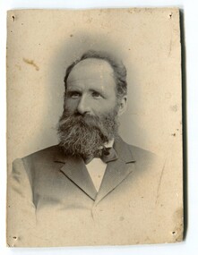
black / white photograph, C1893
This is a photograph of John Johnston. John Johnston was elected as a member of the Orbost Council and during thirty-five years of service, he was president four times. He was also president of the Agricultural Society and Chairman of the local School Committee for over thirty years, (from Richard Johnston -1969 in "Personalities and Stories of the Early Orbost District: by Mary Gilbert)John Johnston was a prominent citizen of Orbost in the late 19th and early 20th centuries. He was referred to as "the father of the council".A black / white portrait photograph of a man, with beard and moustache, wearing a bow tie and suit jacket. johnston-john orbost-shire-council -
 Bendigo Military Museum
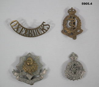
Badge - BADGES, BRITISH, C.1914 - 18 or pre
.1) Oxeford Shire & Buckingham Shires Light Infantry. .3) Cheshire Infantry Regiment. .4) 18th Royal Hussars Cavalry. Items in the collection re John D Gardiner No 2832, refer Cat No 5892.2 for his service details..1) Badge brass curved shape all lettering with two lugs on rear. .2) Badge pressed brass crown at top, wreath and Serpent, scroll at bottom, pin on rear. .3) Badge pressed brass, 8 sided star with central motif, scroll under with raised lettering, pin on rear. .4) Badge pressed silver colour, crown at top, central circle with raised lettering, wreath under and pin on rear..1) "OXE & BUCKS" .2) "Royal Army Medical Corp". .3) "CHESHIRE" .4) Queen Mary's Own". -
 Kiewa Valley Historical Society
Alpine Observer Newspaper - 23 Oct. 1980 x2, 23 Oct. 1980
The Tawonga Primary School celebrated its centenary with a program including a fete, sports, family dance and combined church service over the weekend of the 25th - 26th Oct. 1980. The newspaper covers the Alpine Shire and included further articles that would interest visitors to the centenary.Tawonga School was one of the earliest schools in the Kiewa Valley supplying an education for the children of the local farming community. The Bogong Hotel at Tawonga, the Tawonga Butter Factory and the town of Mt Beauty articles were printed providing up to date historical information on prime locations nearby. Of interest as the Hotel has burnt down and the Butter factory no longer exists. Alpine Observer newspaper dated Thursday, 23 rd October 1980 with a sketch of the school and articles regarding the Centenary of the Tawonga School on the front page. (The paper consists of 12 pages ie. 6 sheets) 2 copies On page 4 is an article on the history of the Bogong Hotel at Tawonga On page 5 is an article on the history of the Tawonga Butter Factory and an article on the township of Mt Beauty.newspaper articles; tawonga primary school; bogong hotel; tawonga butter factory -
 Kiewa Valley Historical Society
Booklet - The Church of the Holy Cross Mount Beauty, The Order of Service for the Dedication of the Church of the Holy Cross Mount Beauty, December 1965
The Anglican Church of the Holy Cross was situated in Maddison St., Mt Beauty. It was dedicated on Saturday 18th December 1965. The Rector was The Reverend Colin G. Burgess Th.L.Mt Beauty was created by the State Electricity Commission of Victoria during the construction of the Kiewa Hydro Electric Scheme. During the late 1960's the town was handed over to the Bright Shire and its building sold. A plaque was unveiled in the porch to commemorate the Dedication of the Church by Mr H. H .Williams, the chief engineer of the Kiewa Scheme.5 page hand made book with white pages and black typing stapled together with 4 staples. The book includes the Order of Service, The Procession to the Altar, The dedication of the Church, The dedication of the Furniture, At the Prayer Desk, At the Lectern At the Pulpit, At the Chancel Step, At the Altar, The Dedication Mass, The Collect, The Epistle, The Gospel, Proper Preface and is written by the Right Reverend Theodore Bruce McCall, Fourth Bishop Of Wangaratta on Saturday, 18th Dec., 1965mt beauty; anglican church; religion; -
 Kiewa Valley Historical Society
Photographs – Kiewa Cres Mt Beauty. Circa 1993. Set of 12 colour photographs
Established in 1946, during the construction of the Kiewa Hydro Electric Scheme, the township of Mt Beauty was developed by the State Electricity Commission of Victoria to provide additional accommodation for the thousands of workers during the construction of the country’s second largest hydro-electricity scheme. Although these towns were built as temporary accommodation for the workers and their families, many stayed after the scheme finished. Combined with the influx of European migrants, with their rich cultural backgrounds, all played a major part in shaping the future character of the Mount Beauty, the Kiewa Valley and Falls Creek. The Bright Council, now the Alpine Shire took over the control of the township in 1960. This relatively young town of Mount Beauty, along with the surrounding townships of Falls Creek, Bogong, Tawonga South and Tawonga, are all part of a prospering tourist area with excellent services, accommodation, food and a wide range of recreational activities available for all ages. According to Shire records, the population of Mt Beauty has grown from 1,500 in 1981 to 1,800 in 2016 with a projected increase to 2,000 in 2013The photographs taken around 1993 show a prosperous commercial centre catering for both locals and the needs of visitors. It provides a pictorial history of the changes which have occurred in the retail/commercial district of Mt Beauty over the years. It also demonstrates the attention paid by Alpine Shire towards providing accessible recreational green space around the town centre.Set of 12 colour photographs of Kiewa Cres Mt Beauty. Circa 1993 showing retail services and streetscape of the time. No markingskiewa cres mt beauty, mt beauty -
 Kiewa Valley Historical Society
Photographs – Lakeside Avenue, Mt Beauty. Circa 1993. Set of 7 colour photographs
Established in 1946, during the construction of the Kiewa Hydro Electric Scheme, the township of Mt Beauty was developed by the State Electricity Commission of Victoria to provide additional accommodation for the thousands of workers during the construction of the country’s second largest hydro-electricity scheme. Although these towns were built as temporary accommodation for the workers and their families, many stayed after the scheme finished. Combined with the influx of European migrants, with their rich cultural backgrounds, all played a major part in shaping the future character of the Mount Beauty, the Kiewa Valley and Falls Creek. The Bright Council, now the Alpine Shire took over the control of the township in 1960. This relatively young town of Mount Beauty, along with the surrounding townships of Falls Creek, Bogong, Tawonga South and Tawonga, are all part of a prospering tourist area with excellent services, accommodation, food and a wide range of recreational activities available for all ages. According to Shire records, the population of Mt Beauty has grown from 1,500 in 1981 to 1,800 in 2016 with a projected increase to 2,000 in 2013The photographs taken around 1993 show a prosperous commercial centre catering for both locals and the needs of visitors. It provides a pictorial history of the changes which have occurred in the retail/commercial district of Mt Beauty over the years. It also demonstrates the attention paid by Alpine Shire towards providing accessible recreational green space around the town centre.Set of 7 colour photographs of Lakeside Avenue, Mt Beauty. Circa 1993 showing retail services and streetscape of the time. No markingsmt beauty, lakeside ave mt beauty -
 Kiewa Valley Historical Society
Photographs – Tawonga Cres., Mt Beauty. Circa 1993. Set of 4 colour photographs
Established in 1946, during the construction of the Kiewa Hydro Electric Scheme, the township of Mt Beauty was developed by the State Electricity Commission of Victoria to provide additional accommodation for the thousands of workers during the construction of the country’s second largest hydro-electricity scheme. Although these towns were built as temporary accommodation for the workers and their families, many stayed after the scheme finished. Combined with the influx of European migrants, with their rich cultural backgrounds, all played a major part in shaping the future character of the Mount Beauty, the Kiewa Valley and Falls Creek. The Bright Council, now the Alpine Shire took over the control of the township in 1960. This relatively young town of Mount Beauty, along with the surrounding townships of Falls Creek, Bogong, Tawonga South and Tawonga, are all part of a prospering tourist area with excellent services, accommodation, food and a wide range of recreational activities available for all ages. According to Shire records, the population of Mt Beauty has grown from 1,500 in 1981 to 1,800 in 2016 with a projected increase to 2,000 in 2013The photographs taken around 1993 show a prosperous commercial centre catering for both locals and the needs of visitors. It provides a pictorial history of the changes which have occurred in the retail/commercial district of Mt Beauty over the years. It also demonstrates the attention paid by Alpine Shire towards providing accessible recreational green space around the town centre.Set of 4 colour photographs Tawonga Crescent, Mt Beauty. Circa 1993 showing retail services and streetscape of the time No markingstawonga cres mt beauty -
 Kiewa Valley Historical Society
Photographs – Holland Street North, Mt Beauty. Circa 1993. Set of 18 colour photographs
Established in 1946, during the construction of the Kiewa Hydro Electric Scheme, the township of Mt Beauty was developed by the State Electricity Commission of Victoria to provide additional accommodation for the thousands of workers during the construction of the country’s second largest hydro-electricity scheme. Although these towns were built as temporary accommodation for the workers and their families, many stayed after the scheme finished. Combined with the influx of European migrants, with their rich cultural backgrounds, all played a major part in shaping the future character of the Mount Beauty, the Kiewa Valley and Falls Creek. The Bright Council, now the Alpine Shire took over the control of the township in 1960. This relatively young town of Mount Beauty, along with the surrounding townships of Falls Creek, Bogong, Tawonga South and Tawonga, are all part of a prospering tourist area with excellent services, accommodation, food and a wide range of recreational activities available for all ages. According to Shire records, the population of Mt Beauty has grown from 1,500 in 1981 to 1,800 in 2016 with a projected increase to 2,000 in 2013The photographs taken around 1993 show a prosperous commercial centre catering for both locals and the needs of visitors. It provides a pictorial history of the changes which have occurred in the retail/commercial district of Mt Beauty over the years. It also demonstrates the attention paid by Alpine Shire towards providing accessible recreational green space around the town centre.Set of 18 colour photographs Holland Street North, Mt Beauty. Circa 1993 showing retail services and streetscape of the time. No markingsholland st mt beauty, mt beauty -
 Kiewa Valley Historical Society
Photographs – Holland Street South, Mt Beauty. Circa 1993. Set of 16 colour photographs
Established in 1946, during the construction of the Kiewa Hydro Electric Scheme, the township of Mt Beauty was developed by the State Electricity Commission of Victoria to provide additional accommodation for the thousands of workers during the construction of the country’s second largest hydro-electricity scheme. Although these towns were built as temporary accommodation for the workers and their families, many stayed after the scheme finished. Combined with the influx of European migrants, with their rich cultural backgrounds, all played a major part in shaping the future character of the Mount Beauty, the Kiewa Valley and Falls Creek. The Bright Council, now the Alpine Shire took over the control of the township in 1960. This relatively young town of Mount Beauty, along with the surrounding townships of Falls Creek, Bogong, Tawonga South and Tawonga, are all part of a prospering tourist area with excellent services, accommodation, food and a wide range of recreational activities available for all ages. According to Shire records, the population of Mt Beauty has grown from 1,500 in 1981 to 1,800 in 2016 with a projected increase to 2,000 in 2013The photographs taken around 1993 show a prosperous commercial centre catering for both locals and the needs of visitors. It provides a pictorial history of the changes which have occurred in the retail/commercial district of Mt Beauty over the years. It also demonstrates the attention paid by Alpine Shire towards providing accessible recreational green space around the town centre.Set of 16 colour photographs Holland Street South, Mt Beauty. Circa 1993 showing retail services and streetscape of the time. No markingsholland st mt beauty, mt beauty -
 Kiewa Valley Historical Society
Papers - Centenary Bright-Tawonga Road, 19th March 1996
The Bright-Tawonga Road was built in 1896, connecting the Ovens and Kiewa valleys. The article gives an description of the event.The Bright - Tawonga road connected Tawonga to the larger town of Bright and the closest railway service. This road provided the Upper Kiewa Valley with access to larger markets, alternative transport and increased facilities not available in the Kiewa Valley in the early, pre SEC days. It describes how roads were built in 1896 with little machinery. The KVHS has in its collection the dray used to help build the road. One page article from the 'Shire News' dated 19th March 1996bright-tawonga road, road works, kiewa valley, ovens valley, dray -
 Kiewa Valley Historical Society
Photographs – Kiewa Cres Mt Beauty. Circa 1993. Set of 12 colour photographs, circa 1993
Established in 1946, during the construction of the Kiewa Hydro Electric Scheme, the township of Mt Beauty was developed by the State Electricity Commission of Victoria to provide additional accommodation for the thousands of workers during the construction of the country’s second largest hydro-electricity scheme. Although these towns were built as temporary accommodation for the workers and their families, many stayed after the scheme finished. Combined with the influx of European migrants, with their rich cultural backgrounds, all played a major part in shaping the future character of the Mount Beauty, the Kiewa Valley and Falls Creek. The Bright Council, now the Alpine Shire took over the control of the township in 1960. This relatively young town of Mount Beauty, along with the surrounding townships of Falls Creek, Bogong, Tawonga South and Tawonga, are all part of a prospering tourist area with excellent services, accommodation, food and a wide range of recreational activities available for all ages. According to Shire records, the population of Mt Beauty has grown from 1,500 in 1981 to 1,800 in 2016 with a projected increase to 2,000 in 2013The photographs taken around 1993 show a prosperous commercial centre catering for both locals and the needs of visitors. It provides a pictorial history of the changes which have occurred in the retail/commercial district of Mt Beauty over the years. It also demonstrates the attention paid by Alpine Shire towards providing accessible recreational green space around the town centre.Set of 12 colour photographs Kiewa Cres Mt Beauty. Circa 1993 showing retail services and streetscape of the time. No markingskiewa crescent mt beauty; shopping centre;