Showing 4271 items
matching street plan
-
 Federation University Historical Collection
Plan, Barkly Street Campus, Ballarat East, c1950s ?
... Ink on paper plan: Barkly Street Campus. ...' Secondary School Ink on paper plan: Barkly Street Campus. Barkly ...Ink on paper plan: Barkly Street Campus. plans, barkly street campus, ballarat east, ballarat girls', ballarat girls' secondary school -
 Bendigo Historical Society Inc.
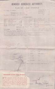
Document - L. PROUT COLLECTION: PLAN OF HOUSE DRAINAGE
... Street. The plan is dated 30/10/1930.... situated at 24 Quick Street. The plan is dated 30/10/1930. Document ...Bendigo Sewerage Authority, Plan of House Drainage. For Mrs. C. Prout, weatherboard property situated at 24 Quick Street. The plan is dated 30/10/1930.organization, public utility, water -
 Ringwood and District Historical Society
Pamphlet, Land Sale Brochure Titled Eureka Plan Book - Seven Delightful & Valuable Ringwood Estates - circa 1925
... Street), Greenwood Avenue, Alton Street and Locke Street. Plan... Street and Locke Street. Plan of Bestpart Estate, Ringwood ...Twenty page land sale brochure including photographs, subdivision features and local facilities. Additional flyer with conditions of sale and prices for estate blocks.Seven delightful and valuable Ringwood Estates called Bestpart, Paradise, Hill Top, Greenwood, Creek, Station, and School Estates. These nestle amidst the hills and valleys of beautiful Ringwood district. Also Goodluck Estate at Clarinda. Pamphlet marked as being From Mr. Farmer, No. 5 Flinders Court, Melbourne. Phone 988, 989 Central, or 55 Ringwood after 7 p.m. Plan of Ringwood School Estate includes William Street (later Kendall Street), Greenwood Avenue, Alton Street and Locke Street. Plan of Bestpart Estate, Ringwood, includes Bedford Road, Wilana Street, Greenwood Avenue, Caroline Street, Henry Street and Haig Street. Plan of Ringwood Station Estate includes Pitt Street, Bedford Road, Greenwood Avenue, Station Street, William Street (later Kendall Street, James Street, Wantirna Road, Caroline Street, Henry Street, Ellison Street and Haig Street. Plan of Geenwood Estate, Ringwood, includes Prussian Road (later Geenwood Avenue). Plan of Paradise Estate, Ringwood, includes Canterbury Road, Dandenong Road (Wantirna Road), Luck Street and Paradise Road. Plan of Creek Estate, Ringwood, includes Dandenong Creek, Wantirna Road and Gordon Crescent. Plan of Hill Top Estate, Ringwood (later Heathmont area), includes Heathmont Railway Station, Heathmont Road, Balfour Avenue, Lilian Street, Edith Street, Edna Street and Great Ryrie Street. Plan of Goodluck Estate, Clarinda, includes Talbot Avenue, Good Street, Luck Street, and Centre Road in locality plan between Oakleigh and Clayton Railway Stations. -
 Melbourne Tram Museum
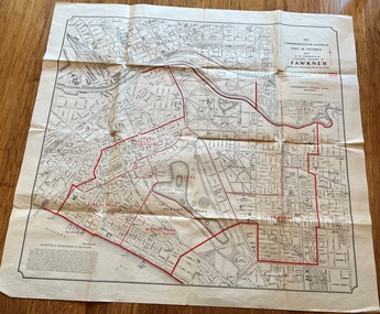
Map, Department of Lands and Survey Melbourne, Commonwealth Electoral Division of Fawkner, 1-10-1912
... Shows a detailed street plan of South Melbourne, Albert... Shows a detailed street plan of South Melbourne, Albert Park ...Shows a detailed street plan of South Melbourne, Albert Park, Prahran, South Yarra and parts of Melbourne in 1912. Used to mark the electoral boundaries of the Commonwealth Electoral Division of Fawkner. Shows all the then cable tram lines, rail lines and the electric line of the PMTT along with docks, gardens and significant buildings.Gives details of the Fawkner Electoral district in 1912.Folded sheet - Map - Commonwealth Electoral Division of Fawkner - two colours showing the subdivisions and polling placesmelbourne, fawkner, tram lines, cable trams, maps, electoral maps, south melbourne, albert park, prahran -
Clunes Museum
Plan - ARCHITECTS PLANS, KEVYN JOY ARCHITECTS, 12 JUNE 2009
... PROPOSED CLUNES NEIGHBOURHOOD HOUSE PLAN TEMPLETON STREET... NEIGHBOURHOOD HOUSE PROPOSED PLANS TEMPLETON STREET PROPOSED CLUNES ...PROPOSED CLUNES NEIGHBOURHOOD HOUSE PLAN TEMPLETON STREET 2009clunes neighbourhood house, proposed plans, templeton street -
Canterbury History Group
Drawing - Illustration, E.Thompson's Villa, 1938
... for E.Thompson in Selwyn Street. includes floor plan dated1938... in Selwyn Street. includes floor plan dated1938 Drawing Illustration ...Illustration of front elevation of a brick villa built for E.Thompson in Selwyn Street. includes floor plan dated1938canterbury, selwyn street, thompson> e., coghill collection -
Whitehorse Historical Society Inc.
Letter - Correspondence, Obtaining a grant of Crown Land at rear of Myrtle Grove, 1932
... re land in Pakenham Street including plans of allotments... Street including plans of allotments. Correspondence between ...Correspondence between Council and Closer Settlement Board re land in Pakenham Street including plans of allotments.Correspondence between Council and Closer Settlement Board re land in Pakenham Street including plans of allotments. Also further correspondence re land being sold by Malcolm Sheehan to Dal Hear.Correspondence between Council and Closer Settlement Board re land in Pakenham Street including plans of allotments.pakenham street, blackburn, myrtle grove, blackburn, shire of blackburn and mitcham, sheehan, malcolm, hearn, dal, victoria. closer settlement board -
Glen Eira Historical Society
Plan - LEMPRIERE AVENUE
... and ‘Greenmeadows Gardens’ Historic Area include street plan and general... Avenue and ‘Greenmeadows Gardens’ Historic Area include street ...One item about this location 1/Excerpts (5 pages) from Andrew Wards Heritage Study vol 2, 3.6 on Lempriere Avenue and ‘Greenmeadows Gardens’ Historic Area include street plan and general view of Roselle Estate’, Greenmeadows Garden. Included in his description is mention of a large eucalypt in ‘Greenmeadows Gardens’ which pre-dates European settlement.streetscape, lempriere avenue, ‘greenmeadows gardens’, meadow street, alston grove, californian bungalow style, fences, spanish mission style, ‘greenmeadows house, lempriere w. g., meadow street, clarke william senior, ‘greenmeadows’, trees, balaclava road, orrong road, allan road, meadow street, lempriere john, kirton mr, dickson and yorston (pty ltd), lempriere ruby l mrs, dickson g c, yorston j c, st kilda east, east st kilda, roselle estate, east st kilda, east st kilda riding -
 Kew Historical Society Inc
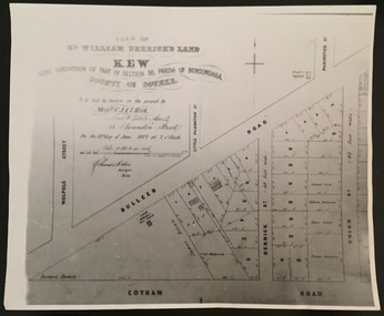
Print - Subdivision Plan, F Price, Plan of Mr William Derrick's Land, Kew being Subdivision of Part of Section 86, Parish of Boroondara, County of Bourke, 1872, 1872 [Original]
... Road and Union Street. The plan dates from 1872.... by Bulleen Road (High Street); Cotham Road and Union Street. The plan ...This work forms part of the collection assembled by the historian Dorothy Rogers, that was donated to the Kew Historical Society by her son John Rogers in 2015. The manuscripts, photographs, maps, and documents were sourced by her from both family and local collections or produced as references for her print publications. Many were directly used by Rogers in writing ‘Lovely Old Homes of Kew’ (1961) and 'A History of Kew' (1973), or the numerous articles on local history that she produced for suburban newspapers. Most of the photographs in the collection include detailed annotations in her hand.The Rogers Collection provides a comprehensive insight into the working habits of a historian in the 1960s and 1970s. Together it forms the largest privately-donated collection within the archives of the Kew Historical Society.A photographic reproduction of a plan in the Vale Collection of the State Library of Victoria showing William Derricks land in the area bordered by Bulleen Road (High Street); Cotham Road and Union Street. The plan dates from 1872.william derrick, subdivision plans -- kew (vic.) -
![Map, Plan of Town Allotments Bacchus Marsh [1891-1897]](/media/collectors/5e461d8021ea67224c82f2a1/items/66acc1c90c778f9f64a3daec/item-media/66acc3990c778f9f64a3e09b/item-fit-380x285.jpg) Bacchus Marsh & District Historical Society
Bacchus Marsh & District Historical SocietyMap, Plan of Town Allotments Bacchus Marsh [1891-1897]
... annotations. Streets identified on plan: Lerderderg Street - Bennett... Library Main Street Bacchus Marsh This plan of town allotments ...This plan of town allotments in Lerderderg Street and Bennett Street also includes the location of many of the buildings, shops, businesses and houses which were present in the retail and business area of Bacchus Marsh in the 1890s. The precise date of the plan is not known but it must be sometime between 1891 and 1897. The Post Office and the Wesleyan Church are both shown on this plan. Both of these were constructed in 1890. The plan does not show the Baptist Church in Main Street which was constructed in 1898. Hence the date is sometime between 1891 and 1897.This plan of Bacchus Marsh is one of the most detailed visual representations of the location of shops, businesses and houses in the central part of Bacchus Marsh. It provides very precise locations of most of the shops and houses in the town in the 1890s. A single page paper plan showing allotments of land fronting Lerderderg and Bennett Street. Buildings, businesses and houses along most of the streets are identified by hand written annotations. Streets identified on plan: Lerderderg Street - Bennett Street - Main Street - Gell Street - Young Street - Graham Street. Physical boundaries of the map are: North border - Lerderderg Street - South border - Main Street - West border Gell Street - East border - Young Street. The plan is pasted into a bound volume containing 76 maps or plans in total. bacchus marsh victoria maps, shops bacchus marsh -
Port Melbourne Historical & Preservation Society
Plan - Area bounded by Nott Street, Graham Street, Esplanade West and Rouse Street, Port Melbourne, 29 Feb 1952
... , Esplanade W. and Rouse Streets with plan showing properties in area..., Graham, Esplanade W. and Rouse Streets with plan showing ...Plan showing properties in area bounded by Nott, Graham, Esplanade W. and Rouse Streets with plan showing properties in area bounded by Station, Graham, Nott and Rouse Streets (House Common Orders) Also statistics of 1948.Top RH corner - reverse: notation - 'residential zoning amendment':Face: continuing notations (at least up to 1963):Lower, indication : 'Existing conditions 1948'built environment - commercial, built environment - civic, built environment - domestic, built environment - industrial, town planning, religion - roman catholic church (st josephs), swallow & ariell ltd, troedel & cooper pty ltd, wilsons sheet metals, franklin & anderson, g h westwood & sons, atlas plastics, w j carr, craven, robert timms, sunkist, tip top paints, knox schlapp pty ltd, daro plastics, triton construct, newmans, national bank, religion - wesleyan methodist church, court house, police station -
 Melbourne Tram Museum
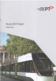
Document - Report, Public Transport Corporation (PTC), "Route 96 Project Overview", 2012
... , Yarra Trams or PTV. Includes photos of Bourke St, street plans.... Includes photos of Bourke St, street plans and information numbers ...Report 12 A4 pages, including card covers, centre stapled, full colour printed on off white paper, titled "Route 96 Project Overview". Looks at the route itself, project objectives, governance arrangements, communications and consultations. Includes a note that the Government has order 50 new trams. Notes the proposed works packages and who would be managing them - VicRoads, Yarra Trams or PTV. Includes photos of Bourke St, street plans and information numbers. Has the State Government, VicRoads and Yarra Trams logos. Published 2012.trams, tramways, ptv, route 96, east brunswick, yarra trams -
 Federation University Historical Collection
Plan, Ballarat Goldfields Geological Survey, 1981
... Large coloured plan showing streets, leads, geological... ballarat gold goldfield geology sebastopol Large coloured plan ...Large coloured plan showing streets, leads, geological zones and shafts. Source 1:10,000ballarat, gold, goldfield, geology, sebastopol -
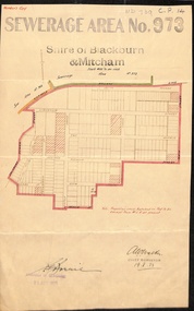 Whitehorse Historical Society Inc.
Document, Sewerage Area, 19/08/1933
... on the plan is now Linum Street.... on the plan is now Linum Street. Sewerage Area Document Document ...Map dated 19 - 8 1933 showing sewerage area no. 973 in the Shire of Blackburn and Mitcham. Note that View Street on the plan is now Linum Street.sewerage and sanitation, shire of blackburn and mitcham, acacia avenue, blackburn, salisbury avenue, laburnum street, view street, derby street, myrtle grove, south parade, the avenue, main street, laurel grove, pakenham street, blackburn., linum street -
Mission to Seafarers Victoria
Letter - Correspondence, 15/09/1951
... some writing and a street plan on the first 'page' only... writing and a street plan on the first 'page' only. The letter ...This letter concerns the imminent arrival of Allan and Alette in London. Pat gives directions to the bed-sitting-room she shares with her husband in London.Quinn CollectionTwo sheets of thin, unlined off-white paper folded in book form (0886.a1-2). There is writing on both sides of the first sheet (four pages of writing); the second sheet of paper has some writing and a street plan on the first 'page' only. The letter is headed 19 Luxemburg Gardens, Hammersmith W6 and dated 12/09/51. The light brown envelope (0886.b) is addressed Mr Allan Quinn, Passenger on "Patricia", and below, in brackets, Arriving Sat. morning 15/9/51. The back of the envelope is badly torn. It would appear the letter was hand-delivered to the shipping office as there are no stamps or post-mark on the envelope Letter commences "My dear Allan" and concludes "...Until then, Yours, Patletters-from-abroad, allan quinn, alette andersen -
 Warrnambool and District Historical Society Inc.
Administrative record (Collection) - Warrnambool City Council Administrative Records, Warrnambool City Council Officers, 1990s
... concerning the environment, business and street scape (City Plans... concerning the environment, business and street scape (City Plans ...Warrnambool City Council Records collected by a member of a Council Advisory Committee.Collection of Warrnambool City Council records of the 1990sIn folders and archival envelopes in an A3 archival boxTwo A3 archival envelopes containing information on Foreshore etc., five booklets containing reports on City Plans, Council Strategies etc and 15 Reports (Shop Trading, Coastal Wetlands, Foreshore, Landcare etc)warrnambool city council, warrnambool city council strategies and planswarrnambool city council, warrnambool city council strategies and plans -
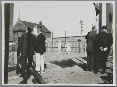 Mission to Seafarers Victoria
Photograph - Photograph, Black and white, Tennis court opening, 18 September 1926
... to Seafarers, 717 Flinders Street. First plan are unidentified men..., 717 Flinders Street. First plan are unidentified men turning ...The picture was possibly taken for the opening of the tennis court Saturday 18 September 1926. Lady Creswell was invited to officially open the court and about a 100 persons attended the ceremony.Photograph taken in 1926 on the tennis court of the Mission to Seafarers, 717 Flinders Street. First plan are unidentified men turning their back to the photographer. On the court are two ladies wearing white tennis attire are playing double. In the background the former Seamen's Institute, Siddeley Street, can be seen as well as the docks on Australian Wharf.tennis, mission to seafarers victoria, tennis court, lady creswell, reverend john reginald weller, 1926, lady adelaide elizabeth creswell nee stow, 1859-1945, william rooke creswell (1852-1933), mission to seamen, weller album -
Port Melbourne Historical & Preservation Society
Document - Specification, Pool Street from Nott Street to Princes Street, Engineering Department, Town of Port Melbourne, 14 Mar 1893
... Plan for Pool Street from Nott Street to Princes Street... Engineering - Roads Streets Lanes and Footpaths Town Planning Town ...Plan for Pool Street from Nott Street to Princes Street Loan Works 1893 plan 18; relates to plan 97.2Signed by JJ Bartlett (Mayor) 14.3.1893engineering - roads streets lanes and footpaths, town planning, town clerks, mayors, arthur victor heath, james john bartlett -
Port Melbourne Historical & Preservation Society
Plan - Pool Street from Nott Street to Princes Street, Engineering Department, Town of Port Melbourne, 14 Mar 1893
... Plan for Pool Street from Nott Street to Princes Street... Engineering - Roads Streets Lanes and Footpaths Town Planning Town ...Plan for Pool Street from Nott Street to Princes Street Loan Works 1893 plan 18; relates to specification 97.1Signed by JJ Bartlett (Mayor) 14.3.1893engineering - roads streets lanes and footpaths, town planning, town clerks, mayors, arthur victor heath, james john bartlett -
Port Melbourne Historical & Preservation Society
Plan - Ingles Street, Port Melbourne, 12 Jan 1866
... Plans for Ingles Street showing both ground plan.... Also a no: 355/H1 added later. Plans for Ingles Street showing ...Plans for Ingles Street showing both ground plan and longitudinal and traverse sections at Station Place, Heath, Nott and Bay Streets.Signed by surveyor Chas. Clay and James Bibby plus Thomas (Reek) Warren as witness to latter sig. Also a no: 355/H1 added later.engineering - roads streets lanes and footpaths, charles clay, thomas (reek) warren, james bibby -
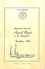 Ringwood and District Historical Society
Pamphlet, F.P. Dwerryhouse, Town Clerk and Treasurer, Ringwood Council's Annual Report To The Ratepayers (December 1961), 1961
... Construction, New Works, Sewerage, Street Lighting, Planning Scheme... Charge, Private Street Construction, New Works, Sewerage, Street ...City of Ringwood community information report issued December 1961, including financial summary and sections covering Re-Valuation, Sanitary Charge, Garbage Removal Charge, Private Street Construction, New Works, Sewerage, Street Lighting, Planning Scheme, Fire Hazards, Fly Control, Dog Nuisance, and list of Council Representatives.rinx -
 Bendigo Historical Society Inc.
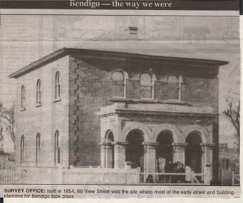
Newspaper - JENNY FOLEY COLLECTION: SURVEY OFFICE
... of the early street and buiolding planning for Bendigo took place.... Inc. History House 11 Mackenzie Street Bendigo goldfields ...Bendigo Advertiser "The way we were" from 1999. Survey Office: built in 1854, 60 View Streeet was the site where most of the early street and buiolding planning for Bendigo took place.newspaper, bendigo advertiser, the way we were -
 Port Fairy Historical Society Museum and Archives
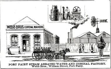
Drawing - large picture, Webb Bros Cordial Factory
... Waters factory on William Street. An 1887 plan shows three... Street Port Fairy great-ocean-road This lithograph shows William ...This lithograph shows William Webb's Cordial and Aerated Waters factory on William Street. An 1887 plan shows three buildings forming part of the factory. Black & white etching of Large building of Webb Bros Cordial factory with delivery cart out front and lower wooden buildings to the leftPort Fairy Steam Aerated Water and Cordial Factory Webb Bros. William Street Port Fairyfactory, business, shop -
 Kew Historical Society Inc
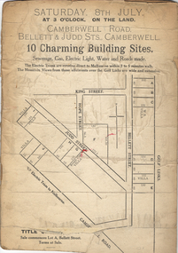
Plan - Subdivision Plan, 10 Charming Building Sites, 1930-1940
... Street. The plan lists existing houses in the vicinity including..., Bellett Street and King Street. The plan lists existing houses ...This subdivision plan shows 10 lots, numbered A-J, that were offered for sale in Camberwell. Streets in the subdivision include Camberwell Road, Judd Street, Bellett Street and King Street. The plan lists existing houses in the vicinity including weatherboard and ‘Rough Cast’ villas. The old Golf Links are identified at the rear of the Bellett Street lots.subdivision plans -- camberwell (vic.) -
 Whitehorse Historical Society Inc.
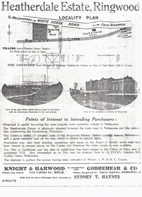
Document, Heatherdale Estate, Ringwood, 1919
... on the plan is now Victory Street and a Railway Avenue is shown which...) to be auctioned September 1919. Station Street on the plan is now Victory ...Brochure advertising 52 lots, Heatherdale Estate, Ringwood (now Mitcham) to be auctioned September 1919.Brochure advertising 52 lots, Heatherdale Estate, Ringwood (now Mitcham) to be auctioned September 1919. Station Street on the plan is now Victory Street and a Railway Avenue is shown which does not now exist.Brochure advertising 52 lots, Heatherdale Estate, Ringwood (now Mitcham) to be auctioned September 1919.land subdivision, heatherdale estate, whitehorse road, mitcham, melbourne and metropolitan board of works, peers, w.h., coane, j.m., h.e., knight & harwood, godbehear & co, haynes, sydney t, walter street, witt street, victory street, purches, frederick walter -
Port Melbourne Historical & Preservation Society
Plan, Graeme Bentley Pty Ltd, Port Melbourne Foreshore Landscape Master Plan MP1(A), February 1993
... Street. The plan proposed extensive tree planting including... Port Melbourne Railway Station to Bay Street. The plan proposed ...The Port Melbourne Foreshore Landscape Master Plan was created by Landscape Architectural firm of Graeme Bentley Pty Ltd for the City of Port Melbourne. MP1(A) portrays the section of foreshore from the former Port Melbourne Railway Station to Bay Street. The plan proposed extensive tree planting including Tasmanian native trees along Station Pier. The plan was not actioned.built environment - recreational facilities, beach street, port melbourne foreshore, station pier -
Port Melbourne Historical & Preservation Society
Plan - Proposed extensions, Heath Street, Port Melbourne Town Hall, E J Pembroke, 15 Oct 1936
... Floor plans, elevations to Heath street; south end; roof... plans, elevations to Heath street; south end; roof plan ...Floor plans, elevations to Heath street; south end; roof plan for proposed extensions to supper room Town Hall 1936. Coloured plans."City of Port Melbourne . Proposed Extensions to Supper Room . Town Hall"port melbourne town hall, pembroke and turner, e j pembroke -
Canterbury History Group
Ephemera - 15 Margaret Street Canterbury, 2009
... Street Canterbury on their plans for restoring the house... owners of 15 Margaret Street Canterbury on their plans ...Notes on an interview with the new owners of 15 Margaret Street Canterbury on their plans for restoring the house. Conducted by Robin Kelly, includes some of the history of the house.canterbury, logan's paddock, babicka family, jokity family, margaret street, victorian style -
NMIT (Northern Melbourne Institute of TAFE)
Book: Furniture and equipment layouts for TAFE colleges Victoria. 1981
... Studies, Loddon Valley Bendigo, Wangaratta and Latrobe Street... Studies, Loddon Valley Bendigo, Wangaratta and Latrobe Street ...A4 size loose pages published by the Public Works Department and the Education Department Victoria in 1981. The contents cover the following Colleges: Moorabin, Dandenong, Collingwood, Newport, Box Hill, Sunraysia, Yallourn, Footscray, RMIT, Preston, School of Mines & Industries Ballarat, McMillan Rural Studies, Loddon Valley Bendigo, Wangaratta and Latrobe Street Complex. Plans and diagrams included.manuals, tafe colleges, preston technical college, collingwood tedhnical college, nmit -
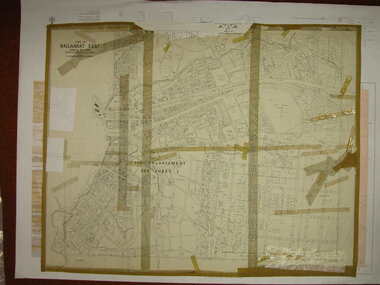 Federation University Historical Collection
Plan, Ballarat East, 1916, 24/05/1916
... Plan of streets and allotments in Ballarat East. Includes... ballarat orphanage Plan of streets and allotments in Ballarat East ...Plan of streets and allotments in Ballarat East. Includes: Bakery Hill, Canadian Station, Eureka Cemetery, Orphan Asylum, Eureka Gardens and Reserve, Gun Clubballarat east, bakery hill, eureka stockade site, eureka gardens, ballarat orphanage