Showing 181 items matching "sunbury road"
-
 Flagstaff Hill Maritime Museum and Village
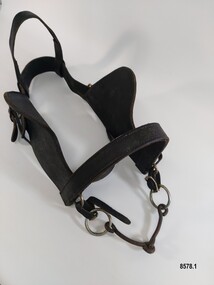
Equipment - Horse Harness, Glenn's Leather Goods, Early to mid-20th century
... Road Sunbury Springvale dray delivery dray harness horse ...The early settlers of Victoria depended on horse drawn vehicles to farm, make roads and railways, deliver produce and transport people. Horse harnesses were an important requisite for all drivers and could be found wherever there were working horses. Horse Harnesses have played an essential role in different cultures throughout history. Simple, utilitarian horse harnesses made of leather straps and iron rings were being used in early China before AD 500 as well as ancient Greece and Rome allowing horses to pull chariots and ploughs. The Greeks and Romans were the first to use a "horse collar" which distributed the weight of the harness evenly across the horse's chest rather than relying on a "throat harness" that could damage a horse's throat or choke them. During the medieval period, European horse harnesses became more elaborate and decorative. Variations of different horse harnesses were also found in Native American and Middle Eastern cultures. Horse Harnesses usually have four basic components which include - 1. Communication - the bridle, bit and reins allows the driver to communicate instructions and commands to the horse, guiding its movement and direction. 2. Draft - the collar, hame straps, hames, traces and chains enables the horse to draw and pull the load efficiently by distributing the weight and transferring the pulling force to the vehicle. 3. Stopping - the breeching band, pole straps and breast strap helps to control or stabilise the horse and vehicle when moving downhill or stopping. 4. Support - the back pad, backband, belly band and back saddle keep the harness in the correct position and proper alignment. This dray harness is a plain, basic harness and reflects its working class origins. It was used by Mr. Oswald (Jack) Bourke with his horse and dray to firstly deliver drygoods from Sunbury to Melbourne in the 1930's and later (through the 1940's and 1950's up to 1961) when he worked on the garbage round for the Springvale City Council. This horse harness is a significant example of the equipment that was needed wherever horses were being used - particularly in the early years of Victoria's settlement by white settlers. Harnesses such as this example were used with drays, farming equipment, delivery carts and personal transportation.A leather and metal horse harness used with a horse and dray circa 1930's to the early 1960's. It is made up of a number of components. 1. A leather bridle with metal buckles and rings, blinkers and a metal single jointed, snaffle bit that has the initials M B stamped onto the leather. 2. A leather bridle with metal buckles and rings and a metal "straight bar" Eggbut snaffle bit. It has an elongated X design (with 4 dots) stamped onto the leather strap holders near each buckle. 3. A blue and white vinyl halter with one leather patched strap. The nose band and a chin strap are covered with woollen padding. 4. A pair of leather shaft protectors. They have lacing holes along each edge and a repeating design of small shapes (flowers, wings, crosses and arrowheads) which run along the front of each protector. 5. A leather strap with a stainless steel chain and catch and a maker's mark for "Glenn's Leather Goods, Pearcedale Victoria" stamped onto the end. 6. A wide leather strap covered with a webbing sleeve. It has two large metal rings and each end and one ring has a rope attached. 7. A leather strap comprised of three separate sections (two shorter and one longer) joined with two metal rings. The longer section has notches along its length and the shorter section at the other end has a buckle. It also had a maker's mark stamped on it but the mark is very worn and the writing is difficult to read. 8. An adjustable leather horse collar with two buckles and straps at the top opening and two "B's" stamped into the leather. The top of the collar is made from treated leather pieces stitched together and the underneath of the collar is untreated leather. It has a padded indentation running all the way around the collar for the hames to sit in. 9. Two pairs of long leather traces - each having a buckle and notched section at one end and each one is made with three lengths of leather spliced together. 10. A leather strap (with one spliced join) belonging to a horse harness with two shorter straps (each ending with a metal clip) attached to a steel D ring at one end. 11. Three assorted short leather straps - the top one has clips at each end and a buckle (for adjusting the length) in the centre, the middle strap has notches and a buckle and the bottom strap is white with notches and a buckle.Bridle with blinkers - "M B" Bridle - design showing an elongated X with a dot in each section stamped onto strap holder Shaft Protectors - stamped design of flowers, wings, crosses and arrowheads Strap with chain - "Glenn's leather goods / Pearcedale / Victoria" Leather Strap (with two metal rings) - Maker's stamp - "name indecipherable / SADDLER / ...OURNE" Collar - "B / B" Leather strap - flagstaff hill maritime museum and village, warrnambool, great ocean road, sunbury, springvale, dray, delivery dray, harness, horse harness, horse drawn vehicles, working horse, oswald (jack) bourke, bridle, horse collar, hames, shaft protectors -
 Hume City Civic Collection
Photograph, early 1980s
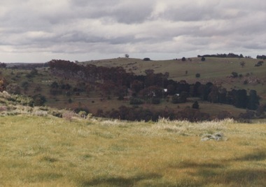
... beyond Elizabeth Drive. sunbury township reservoir road mt ...The photograph shows the extent of Sunbury's development to the west of the town in the early 1980s. The settlement at this stage extended along either side of Gap Road for about 0.5 km beyond Elizabeth Drive.A coloured landscape photograph with rounded corners taken from Mt. Holden and looking towards the expanding town of Sunbury. The Melba Avenue drain which flows into Blind Creek is in the foreground. Sheoak Hill, the site of the former Sunbury Asylum is in the middle of the skyline.sunbury township, reservoir road, mt. holden, sunbury asylum, george evans collection -
 Hume City Civic Collection
Photograph
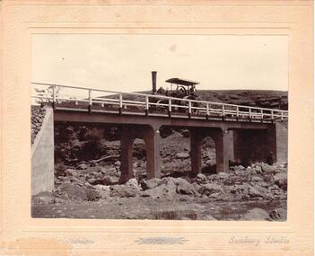
... off the Lancefield Road. gillies bridge wildwood road sunbury ...Chris. Christiansen had a barber shop in Sunbury and was the photographer in the town from 1895 until 1916. He conducted his business in a building situated on the corner of Evans and Brooks Streets. The Gillies Bridge is situated on the Wildwood Road, just off the Lancefield Road.A mounted sepia photograph of the Gillies Bridge at Sunbury. The mounting is cream with silver writing across the bottom of the photograph. There is a man driving a steam roller (traction engine) across the bridge and another man is standing at the bottom of the bridge on the RHS. The creek and rocks are in the foreground. Cream mounting - 2 cm wide with silver inscriptionsChristiansen / Sunbury Studiosgillies bridge, wildwood road, sunbury, bridges, steam rollers, bulldozers, tractors, christiansen, chris, photographers, george evans collection -
 Hume City Civic Collection
Photograph, c1960s
... A black and white photograph of Vineyard Road.... Vineyard Road Sunbury Asylum Sunbury Railway Line George Evans ...The photograph overlooks former railway land along Vineyard Road which is now a commercial and light industrial estate. It was taken before curbing and footpaths were laid and Vineyard Road was narrow strip of asphalt with the sides of the road unmade.A black and white photograph of Vineyard Road with the Sunbury Railway line visible across the middle distance and the former Sunbury Asylum site in the background.vineyard road, sunbury asylum, sunbury railway line, george evans collection -
 Surrey Hills Historical Society Collection
Folder of real estate advertisements, Folders of real estate advertisements (Streets beginning with S), Various
... road sunbury crescent surrey avenue sydenham lane sythney court ...A4 folders with individual pockets for each property in streets beginning with S located in Surrey Hills and Mont Albert. Folders are ordered by street name and then chronologically by property number. Each property has its own pocket. This may include multiple real estate advertisements collected from sales over time. It may also include copies of any research undertaken by Alan Holt and / or members of the SHNCHC team. These are augmented by cards in the Alan Holt index file and by his property registers of Surrey Hills and Mont Albert.st georges avenue, st james avenue, salisbury avenue, scheele street, scottsdale street, serpentine street, shepherd street, shepreth street, sherwood road, shrimpton court, sir garnet road, smythe avenue, stanhope street, streeton court, suffolk road, sunbury crescent, surrey avenue, sydenham lane, sythney court -
 Sunbury Family History and Heritage Society Inc.
Photograph, Rosa McCall, Aboriginal significant ring site, April 2018
... in Sunbury. It is situated on a hillside overlooking Riddell Road ...This photograph is of one of the Aboriginal sites in Sunbury. It is situated on a hillside overlooking Riddell Road near the water tanks. It is uncertain what part this ring played in Aboriginal culture but it is thought to be a place where men gathered. Another ring lower down the hillside is thought to be where the women gathered.A coloured photograph of a hillside with low growing plants in the foreground and the outline of a ring on the opposite hillside.aboriginal cultural rings, riddell road, sunbury -
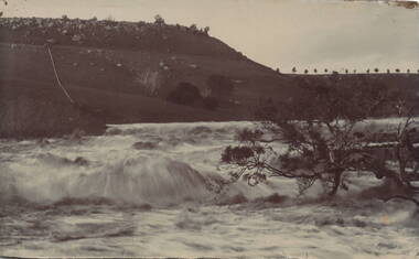 Sunbury Family History and Heritage Society Inc.
Photograph, Jacksons Creek
... of trees in the distance are growing along Macedon Street (Sunbury... of trees in the distance are growing along Macedon Street (Sunbury ...The photograph of the waterfall tumbling over rocks in the Jacksons Creek are a feature downstream from the Macedon Street bridge and Craiglee when the there has been high rainfall. The steep escarpment on the LHS leads to Jacksons Hill and the line of trees in the distance are growing along Macedon Street (Sunbury Road).After heavy rainfall, Jacksons Creek rises suddenly and small trickles over the rocky outcrops become fast flowing waterfalls.A non-digital sepia photograph backed onto thick cardboard of a waterfall tumbling over rocks in a river with a high escarpment rising up from the watercourse. There are rocky outcrops across the hillside with a pipe down the hillside. jacksons creek, jackson hill, waterfalls, rivers -
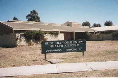 Sunbury Family History and Heritage Society Inc.
Photograph, Elwyn Davis, Former Sunbury Community Health Centre, March 2002
... Cnr. Horne Street and Gap Road, Sunbury, Victoria ...The first Sunbury Community Health Centre was built on the corner of Horne Street and Gap Road in a temporary building. As result of further funding in 1974, a permanent building was erected and opened in 1981 and operated from that site until 2000 when it was relocated into a larger and more modern building on the former Sunbury Primary School site in Macedon Street to accommodate Sunbury's expanding population and needs.It now operates under the name of Sunbury and Cobaw Community Health Centre. The old building was demolished and replaced with a fast-food outlet.A non-digital coloured photograph of the Sunbury Community Health Centre showing the notice board displayed in the front giving phone details and parking area.sunbury community health centre, health centres, gap road, horne street -
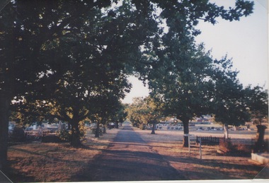 Sunbury Family History and Heritage Society Inc.
Photograph, Lydia Kenworth, Sunbury Cemetery, March 2001
... Cemetery Road, Sunbury, Victoria, Australia. ...The avenue of trees is along the main pathway of the old section of the Sunbury Cemetery. In 1862 the cemetery in Sunbury was laid out in Christian denominational sections. There were other sections set aside for paupers, heathens and pagans. Over the years the size of the cemetery has increased to keep pace with the growth of Sunbury's population.Sunbury Cemetery is one of the oldest cemeteries in the local area.A non-digital coloured photograph of an avenue of trees in a cemetery. The photograph is one of a collection of images that was entered in a photograph competition organised by the former Sunbury & District Heritage Association in March 2001.cemeteries, sunbury, sunbury cemetery -
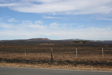 Sunbury Family History and Heritage Society Inc.
Photograph, Rosa McCall, Riddell Road, February 2014
... Riddell Road, Sunbury, Victoria, Australia... north of Sunbury from the Calder Highway across Riddell Road ...In February 2014 severe grassfires blazed across the land north of Sunbury from the Calder Highway across Riddell Road and on to Clarkefield and beyond and caused damage to the Bendigo Railway line. This image was taken about a week later along Riddell Road and looking SW to Red Rock across the skyline.This grass fire caused much damage across a large area north of Sunbury and beyond.A coloured photograph of an open landscape that has been extensively burnt after grassfires.grass fires, riddell road, red rock, sunbury -
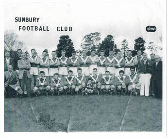 Sunbury Family History and Heritage Society Inc.
Photograph, Sunbury Football team 1958, 1958
... Riddell Road, Sunbury, Victoria, Australia ...This 1958 photograph of the Sunbury Football Club members was taken on the club's home ground at Clarke Oval, named after the Clarke family from Rupertswood.. The team was known as 'The Swifts'.A non-digital scanned black and white photograph with a cream border of a football team Sunbury Football Club 1958sunbury football club, "the swifts', clarke oval -
 Hume City Civic Collection
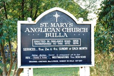
Photograph, late 1990s
... of Oaklands and Sunbury Roads and is covered with vegetation... of Oaklands and Sunbury Roads and is covered with vegetation ...St. Mary's Anglican Church at Bulla was originally built on the outskirts of Bulla township in 1858. In the early 1970s it was moved to its present site to make way for the flight path at the newly constructed Tullamarine Airport. The former site was on the corner of Oaklands and Sunbury Roads and is covered with vegetation. The church was designed by Thomas Taylor.A coloured photograph of the board which is along the fence line outside St. Mary's Church at Bulla. The white writing is on a navy blue background and is framed in white. The notice gives details of services, clergy and caretaker.churches, religion, anglican church, taylor, thomas, potter, charles e. rev., prior, a., st. mary's anglican church, george evans collection -
 Hume City Civic Collection
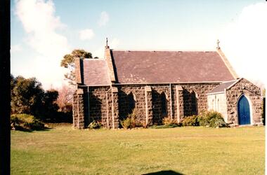
Photograph, late 1990s
... of Oaklands and Sunbury Roads and is covered with vegetation... of Oaklands and Sunbury Roads and is covered with vegetation ...St. Mary's Anglican Church at Bulla was originally built on the outskirts of Bulla township in 1858. In the early 1970s it was moved to its present site to make way for the flight path at the newly constructed Tullamarine Airport. The former site was on the corner of Oaklands and Sunbury Roads and is covered with vegetation. The church was designed by Thomas Taylor.A profile view of the west side of St. Mary's Anglican Church at Bulla and the garden area around the church. A slate covered gable roof has been constructed over the porch nave and chancery with a cross at each end of the roof over the nave. 6 bluestone buttresses and 3 lance windows are along the side with 3 small lancet windows and a blue painted wooden lancet door on the porch.churches, religion, taylor, thomas, st. mary's anglican church, george evans collection -
 Hume City Civic Collection
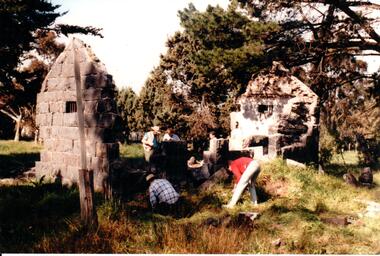
Photograph, c 1993
... at The Gap which was south of the junction of Gap Road (Sunbury Road... at The Gap which was south of the junction of Gap Road (Sunbury Road ...Aitkens Gap Police Lock up was originally constructed at The Gap which was south of the junction of Gap Road (Sunbury Road) and Calder Highway (Victoria St/Mt. Alexander Road). It was part of a police complex which was a changeover station for the gaol escort. The goal was relocated and rebuilt in the police station grounds in Sunbury in 1993.A coloured photograph of five men working on the removal of Aitkens Gap Gaol from its original site. Two end walls of the gaol are standing and the work is being done on the front and back of the building. Conifers and cypress trees are growing around the site.peter free, aitkens gap gaol, police historical association, sunbury police station, george evans collection -
 Sunbury Family History and Heritage Society Inc.
Photograph, Bulla P, 1988
... approaching the township along the Sunbury Road on the west side... the township along the Sunbury Road on the west side of the town ...The photograph was taken from the west side of Bulla Hill near Loemans Road, which is west of the township of Bulla. The rocks outlining the name of the town were a landmark when approaching the township along the Sunbury Road on the west side of the town. They remained there until the school was closed in 1996 and the new owner removed them.A coloured photograph of Bulla Primary School with the word 'Bulla' formed from rocks on the distant hillside. schools, bulla primary school -
 Hume City Civic Collection
Photograph, 1/08/1986
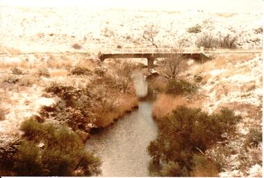
... on the Konagaderra Road near Sunbury.... taken near the bridge on the Konagaderra Road near Sunbury ...A series of photographs were taken when heavy snow fell in Sunbury in August 1986. The snow began falling overnight and remained on the ground for 24 hours. Snow fell across the metropolitan area during that 24 hour period in a very unusual event for the area.A coloured photograph of a snow scene taken near the bridge on the Konagaderra Road near Sunbury.snow falls, weather patterns, winter, konagaderra road, george evans collection -
Hume City Civic Collection
Photograph, St. Mary's Church, Bulla, 1970S
... at the corner of Oaklands and Sunbury Roads to the Bulla township... at the corner of Oaklands and Sunbury Roads to the Bulla township ...The church in the image is St. Mary's Church of England in Bulla after it was moved from its original location at the corner of Oaklands and Sunbury Roads to the Bulla township adjacent to the former Bulla Shire Officers. The move was necessary because the building was close to the international airport and its location interfered with the airport's signaling system and cracks were appearing in its structure from vibrations caused by lowlying aircraft.A coloured non-digital photograph of a small bluestone church set in an open area with a line of gum trees in the background.churches, st. mary's anglican church - bulla, bulla, tullamarine airport -
Hume City Civic Collection
Container - Bottle - Wine, Digger's Rest Vineyard Pinot Noir 1994
... Road, Sunbury 3429....../VINEYARD/PINOT NOIR/Old Vineyard Road, Sunbury 3429... Conventional ...This wine bottle was donated by Frank and Judy Hogan for use in the exhibition 'A History of Vineyards in Sunbury' held at the George Evans Museum in 1996. The Digger's Rest Vineyard was planted in 1987. With the help of winemaker Peter Dredge in 1994 the Digger's Rest vineyard was awarded two medals at the Victorian Wine Show.Conventional green glass wine bottle with indented base. A gold, purple, white and black printed label on the front with a drawing of a gold digger on a log. a printed label. A printed label is on the back. There is a small foil label around top of neck of bottle. a gold and black stick on label with 1994 on the lower RH corner.front label: Digger's Rest/VINEYARD/PINOT NOIR/Old Vineyard Road, Sunbury 3429...digger's rest vineyard, wines, bottles, frank and judy hogan, 1980s, 1990s, george evans collection -
 Sunbury Family History and Heritage Society Inc.
Photograph, Chapel Bulla
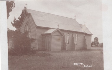
... Church that was on Sunbury Road in the small Bulla township... Church that was on Sunbury Road in the small Bulla township ...The church in the image is the former St. Michaels Catholic Church that was on Sunbury Road in the small Bulla township. After holding religious services at the Daniel property 'Narbonne' at Oaklands Junction until 1876, the permanent church building opened 0n 19th November 1876. Services were held there until the land was sold in the 1980s and the building was demolished despite undergoing renovations in 1978. Members of the Catholic faith then worshipped at the Sunbury Catholic Church. The note on the flip side was written by a Sunbury resident to his sister.A post card with a non-digital sepia photograph of a weatherboard church in an open grassed area. A short note has been written on the flip side of the card.st. michaels church, bulla, catholic church -
 Hume City Civic Collection
Photograph
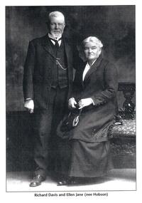
... Jane nee Hobson who owned Winilba Vineyard in Vineyard Road...Hume City Civic Collection 40 Macedon Street Sunbury ...This is a photograph of Richard Davis and his wife Ellen Jane nee Hobson who owned Winilba Vineyard in Vineyard Road, Sunbury.A black and white photograph of an elderly couple. The man is standing and the woman is seated.Written underneath the photograph: "Richard Davis and Ellen Jane nee Hobson"vineyards, winilba vineyard, wineries, vintners, davis, richard, ellen jane nee hobson, sue, kevin, george evans collection -
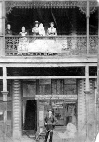 Surrey Hills Historical Society Collection
Photograph, Fred Ambler and Family
... building on the corner of Union and Sunbury Roads, c.1910. Fred... and Sunbury Roads, c.1910. Fred had his carpenter and upholstery ...Fred Ambler and family at Albert Mills Premier Land Agency building on the corner of Union and Sunbury Roads, c.1910. Fred had his carpenter and upholstery business on the ground level and his home above. (No.1) Premier Land Agency Building, was built in 1886-7 by Albert Mills, builder, at 122 Union Road, on the corner of Sunbury Crescent, opposite the Railway Station. Photo shows his wife and family. Alfred died in 1890 and the family moved. The Boroondara Standard in 1888 reported: "Splendid block of brick buildings reaching completion in Union Road adjacent to railway line – 2 storey. Frontage 120 feet for Premier Land Agency. Shops at Ground Level." A sepia coloured photograph of a two storey terrace building with 3 ladies and 2 children standing on the balcony. Downstairs, a gentleman stands outside the shopfront beside two prams. There is a child in one pram.albert mills premier land agency building, (mr) fred ambler, union road, carpenter, upholsterer, sunbury crescent -
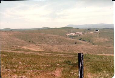 Hume City Civic Collection
Photograph, early 1980s
... . It is a panoramic view of open country NW of Sunbury near Riddell Road... of Sunbury near Riddell Road. There is a fence post with barbed wire ...The Sunbury Tip was transferred from the end of Reservoir Road as housing development spread in that area to a site on the NW side of Mt. Holden near Riddell Road in the early 1980s.A landscape coloured photograph with rounded corners. It is a panoramic view of open country NW of Sunbury near Riddell Road. There is a fence post with barbed wire hanging from it in the immediate foreground and Macedon Ranges and part of the Western Highlands can be seen across the skyline.macedon ranges, mt. macedon, camel's hump, sunbury municipal tip, george evans collection -
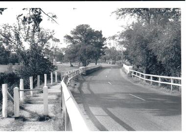
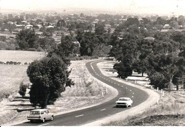 Hume City Civic Collection
Photograph, Early 1970s
... to Sunbury and the Sunbury township before the road was widened...Hume City Civic Collection 40 Macedon Street Sunbury ...In the early 1970s the eastern approach to Sunbury was changed. The stone bridge spanning the Jacksons Creek was replaced by a wider concrete structure and dangerous curves were taken out of the road. The area on the LHS of the photograph including the two arched stone bridge has been incorporated into a public picnic area.A black and white panoramic view of the eastern approach to Sunbury and the Sunbury township before the road was widened and straightened and the new bridge was built. There are two cars in the foreground. One is approaching the bridge and the other is leaving Sunbury.macedon street, macedon street road bridge, jacksons creek, sunbury township, george evans collection -
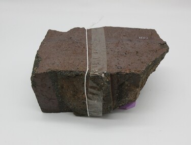 Hume City Civic Collection
Brick
... the years 1859 - 1883 on crown land near Watson's Road, Sunbury... the years 1859 - 1883 on crown land near Watson's Road, Sunbury ...This half broken brick comes from the brickworks owned by Robinson Allison. The brickworks operated approximately between the years 1859 - 1883 on crown land near Watson's Road, Sunbury. This brick may have come from a ruin near the Organ Pipes.Approximately half a brick brown/red colour smooth at one end uneven sides.on top - "ALLISONS'1860s, 1880s, sunbury, brick, shire of bulla, dunn, trevor, margaret, allison, robinson, george evans collection -
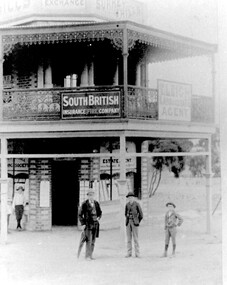 Surrey Hills Historical Society Collection
Photograph, Timothy Leigh's Estate Agency, c 1900, c 1900
... and the boys are his sons. The building was on the corner of Union Road... and the boys are his sons. The building was on the corner of Union Road ...Donor information is that the man is Timothy Leigh and the boys are his sons. The building was on the corner of Union Road and Sunbury Crescent. This site was later occupied by New Litho P/L (printers).B&W photo of a 2 storey Victorian building with ornate lacework trim and veranda panels to the upper storey. Signage on the veranda includes "South British Insurance Fire Company" and "T Leigh Land & Estate Agency". The block next door is vacant with some coverage with small trees. A man and 3 boys are standing in front of the building on the roadside.Diagonally across the top LH corner in black ink: "JB & H Leigh" Top centre: "C/O Sunbury Cres and / Union Rd / c1893 / Timothy LEIGH and sons" in blue biro in Alan holt's handwriting, the in the same handwriting on a rectangular white sticker: "SURREY HILLS PROPERTY EXCHANGE BUILDINGS / (N.W. corner of Sunbury Cres and Union Rd SH) / c1893 / Timothy Leight - Estate Agent / with sons Henry and Herbert / (From Mrs Esler HENSHAW of C'bury - Granddaughter / of Timothy and daughter of Henry LEIGH)" Then centre in the same handwriting "3129" Then on a white sticky label in Jocelyn Hall's handwriting: "Given by Mrs Henshaw / to Alan Holt / who gave them to / N. C. Collection" leigh, timothy, real estate agents, insurance agents, t leigh life & estate agency -
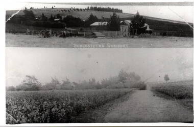 Hume City Civic Collection
Photograph, Schlossberg Vineyard, 1909
... Schlossberg Vineyard was situated along Vineyard Road...Hume City Civic Collection 40 Macedon Street Sunbury ...Schlossberg Vineyard was situated along Vineyard Road in Sunbury, between Winilba and the Calder Highway. It was established by Felix Frederick Bubeck, who arrived in Australia from Rotenberg (near Stuggart) in the 1860. In 1866 he acquired 60 acres of land on Bald Hill and established the vineyard. In 1880, claret produced on the property received an honourable mention when it was exhibited in Bordeaux, France,From the mid 1850s a number of vineyards were established on the hillsides overlooking Vineyard Road. The east facing outlook that captured the morning sun was ideal for growing grapevines. Other vineyards were also established in the area at the same time.A black and white copy of a postcard of two photographs mounted on the one card with the original handwritten message photocopied on the back. To my dear brother & sister with love and good wishes for a Merry Xmas & a prosperous 1909. Thanks for the paper Your loving sister Marie. You will think it a good photo You will see the trees have grown almost hiding the house. Mr. A Senling, Cheetham St. Kalgoorlie Sth. WAfelix frederick bubeck, schlossberg vineyard, bald hill, vineyards -
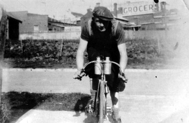 Surrey Hills Historical Society Collection
Photograph, Arthur Lyons of 55 Sunbury Crescent, Surrey Hills
... Taken outside the Lyons' home in Sunbury Crescent... in Sunbury Crescent with Union Road shops in the background. It shows ...Taken outside the Lyons' home in Sunbury Crescent with Union Road shops in the background. It shows the brick substation which stood by the railway gates. The paling fences are along Stirling Crescent, across the railway line. Arthur was the only son of Frederick Adolphus Lyons (1891-1980) who was born in Surrey Hills, son of Thomas and Catherine Lyons. He married Elizabeth Ruby Hall in 1918. They lived at 55 Sunbury Crescent. The Lyons’ home was called ‘Knopshambury’ - this was probably a misspelling of Knockshanbally in Co Kilkenny, the birth place of Fred’s father, Thomas Edmund Josias Lyons (1846-1915). Arthur Lyons was born in Surrey Hills on 12 Jun 1920. He became a motor mechanic / welder and lived at 55 Sunbury Crescent. This is one of a series of photos donated by Arthur Lyons. The donation was made while he was in hospital. He died shortly afterwards (23 Sep 1990). Donation was finalised by a neighbour, Mrs Florence Ann Armitstead, wife of Glen Victor Armitstead. Glen was a local hairdresser. They moved to 11 Sunbury Crescent after their marriage in 1939. Arthur had no relatives to distribute the material to.A black and white photograph of a man, with his bicycle. In the background is the railway line and buildings one of which has a sign advertising a grocer.sunbury crescent, surrey hills, stirling crescent, railway line, grocers, (mr) arthur lyons, (mr) arthur frederick lyons, cyclist -
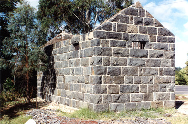 Victoria Police Museum
Police stations (Aitken's Gap)
Aitken's Gap, otherwise known as The Gap or Buttlejork, and 3km west of Sunbury, was established as a township in 1845. It is in the area which is now bordered by the Calder Highway and Gap Road. The village was named after John Aitken, a Port Phillip pastoralist who took up the Mount Aitken run in 1836. Aitken's Gap Police Barracks (in the District of Bourke) opened in 1853 and was staffed by two Mounted Constables and one Foot Constable. The gaol (used to house prisoners and also gold en route to Melbourne) was built in 1857 from bluestone quarried in the area. The roof was made of slate. In 1861 it was staffed by 1 Mounted Senior Constable and 1 Foot Constable. The Barracks closed in 1863 when the Bendigo rail line was completed and the gold was transported to Melbourne by rail. All the buildings, except the gaol, were moved to Sunbury. The land was sold in 1870 and in 1989 the current owner donated the building to the Sunbury Police. The original building was dismantled, restored and rebuilt outside Sunbury police station.15 colour photos and 1 black and white photopolice stations; aitken's gap police station -
 Hume City Civic Collection
Photograph
In the 1970s the bluestone bridge over Jackson's Creek ceased to be used and a wider bridge was constructed to its north. The curved approach to the bridge was taken out of the road and the old approach area was redeveloped and is now Apex Park.A black and white photograph of the old stone bridge over Jackson's Creek in Macedon Street. A utility is in the distance approaching the bridge.macedon street, jackson's creek, bridges, transport, apex park, sunbury, jackson's creek bridge, george evans collection -
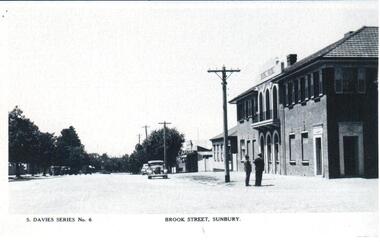 Hume City Civic Collection
Photograph, Early 1950s
A copy of one of the few postcards of Sunbury produced in the 1950s. It may have been produced for the 'Back to Sunbury' celebrations in 1952.A photocopy of a postcard showing the Royal Hotel on the corner of Evans Street and Brook Street looking east towards O'Shanassy Street. Two men are standing on the corner and the roads are not made and there are cars parked along the footpath.S. DAVIES SERIES NO 6 BROOK STREET SUNBURYbrook street, sunbury, hotels, evans street, postcards, festivals and celebrations, men, clothing and dress, transport, royal hotel, 1950s, george evans collection