Showing 62 items matching "surface site"
-
 Eltham District Historical Society Inc
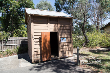
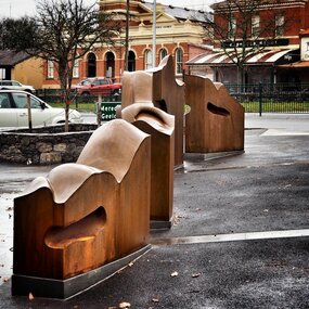
Photograph, Peter Pidgeon, Eltham Lock-up, 4 Mar 2017
This portable lock up is not original to the site. The date of construction is unknown. It is a pre-fabricated design and each of the timber panels are individually numbered on the inside surfaces. It is amongst a large group of portable locks up, categorised as 'Portable Lock Up - Timber - Later' and also known as the "Casterton style", based on the only known plan for portable lock ups, built for the Casterton Police Station, in 1907. The later portables have been in use since the 1880s. It is not known how many lock ups of this type have been constructed in Victoria. At least 50 examples have been documented around the state. Of these, 42 are known to be extant. This lockup used to be located at the Police Station in Pryor Street and was then stored in Youth Road before being acquired for the Local History Centre in 2001. Lock-up No. 17 taken on the ocassion of the opening of the newly refurbished Eltham Local History Centre Open Day, 4 March 2017, Celebrating 50 years of the Society 1967-2017.Born Digitalactivities, eltham district historical society, local history centre, main road, eltham, 50th anniversary, open day, lock up, lock-up, gaol, jail -
 Kiewa Valley Historical Society
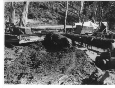
Photograph, logging at McKay Creek, Logging at McKay Creek, c1950's
This photograph was probably taken at the site of McKay Creek Power Station. Excavation of this site did not commence until 1951 but road access(a narrow track) was provided in 1948 and widened in 1954. The logs would have been milled for timber at the State Electricity Commission's mill at Howman's Gap and thus provided a much needed source of timber for construction of camps and houses as there was a general of shortage of this commodity. Because of trouble with landslides in this area, a decision was made to place the machine hall of the power station underground instead of on the surface. Restricted financial resources and the repositioning of the power station retarded construction activities and it was not completed until early 1961.. An excellent pictorial record of the general working conditions, type of machinery and vehicles in use in the 1950/s.Black and white photograph showing logging equipment, fallen logs.Handwritten on the back of the photograph "Logging at McKay Creek)logging, mckay creek, timber, machinery -
 Warrnambool and District Historical Society Inc.
Tools, Name Stamp, Late 19th century/early 20th century
This is the stamp used by Ernest Phillips to mark his tools and his products. It was used both on wood and metal surfaces. Ernest Brighton Phillips (1875-1924) was born in Warrnambool and was apprenticed as a cabinet maker at the Warrnambool Box Works. By the 1890s he had established a furniture shop at the corner of Liebig and Koroit Streets and by the beginning of the 20th century he had the largest furniture warehouse and factory in Victoria outside of Melbourne. His products were sold all over Australia. He and his family lived at ‘Heatherlie’ in Koroit Street and today this site is occupied by the flats complex for senior citizens called ‘Heatherlie’. This stamp is of interest because it belonged to Ernest Phillips, a prominent Warrnambool businessman (late 1800s to the early 1900s.) It is also of interest as an example of an early name stamp. This is a small piece of metal with a rounded flange top and a wider flattened end. The end is serrated and cut to hold the letters, ‘E. Phillips’. Some white paint has been splashed on the end section.‘E.Phillips’ (letters reversed for stamping purposes)ernest phillips, history of warrnambool -
 Glen Eira Historical Society
Album - Album page, Paynswicke, Gladstone Pde & Hartington St, Circa 1972
This photograph is part of the Caulfield Historical Album 1972. This album was created in approximately 1972 as part of a project by the Caulfield Historical Society to assist in identifying buildings worthy of preservation. The album is related to a Survey the Caulfield Historical Society developed in collaboration with the National Trust of Australia (Victoria) and Caulfield City Council to identify historic buildings within the City of Caulfield that warranted the protection of a National Trust Classification. Principal photographer thought to be Trevor Hart, member of Caulfield Historical Society. Most photographs were taken between 1966-1972 with a small number of photographs being older and from unknown sources. All photographs are black and white except where stated, with 386 photographs over 198 pages. House is commonly spelt as "Payneswicke".From: Glen Eira Heritage Management Plan (1996) by Andrew Ward and Associates "Payneswicke" is locally significant as a prominent and substantially intact villa of its period, distinguished by its cast cement enrichment, unpainted stuccoed surfaces and commanding aspect to the south-west. Its role for a period as home for local builder, Patrick Millane (compare no. 11 Gladstone Parade) is of interest. In 1889, a nine roomed brick house was in the course of erection on the site. The house was completed in 1890 and Millane took up residence. Millane continued as owner/ occupant in 1894. However, in 1899, although Millane still occupied the house, ownership had been taken over by the Land Mortgage Bank. By 1910, Andrew Brown was occupant. Occupancy passed to Edward Brown by 1920 and to Miss A.N. Brown by 1930. Miss Brown continued to live there in 1941.Page 50 of Photograph Album with three exterior photographs (2 landscape and 1 portrait) of Paynswicke, a double storey house.Hand written: No 13 [top right] / "Paynswicke" N.E. cnr Gladstone Pd & Hartington St [top right] / 8 Oct 1966 [under top left photo] / 50 [bottom right] trevor hart, 1880's, 1890's, payneswicke, patrick millane, gladstone parade, unpainted stuccoed surfaces, cast cement enrichment, hartington street, villa residence, italianate, elsternwick, victorian, mansion, cast iron verandahs, return verandahs, curved windows, full length windows, land mortgage bank, andrew brown, edward brown, a n brown, paynswicke -
 Flagstaff Hill Maritime Museum and Village
Cash Ball
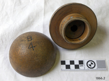
This cash ball was used by Cramond and Dickson, a large clothing store on the corner of Liebig and Timor Streets, Warrnambool. The Cash Ball system serviced the ground floor, which measured about 30 metres by 25 metres. An overhead pipe connected each service point in the store, with the pipes connected to the upstairs office. The ball would be filled with a note of details of the sale, and the cash payment; a vacuum system would be activated that would transport the ball upstairs to the office where details were recorded and change assembled. Change was placed in the ball, and the vacuum system activated to return the ball to the correct sales point. A frequent customer has reported that she never remembered the system not working efficiently, and the service was probably quicker than having a cash register at each sales location. John Glass Cramond and James Dickson migrated from Scotland to Melbourne where they opened a Cramond and Dickson store in St Kilda. They were inspired by the growth in Warrnambool after a visit and opened a second store there in 1855. The Cramond and Dickson store, grocers – drapery – ironmongery - chemist, was located on the corner of Liebig and Timor Streets, Warrnambool (now the site of a Mexican restaurant). Both Cramond and Dickson were involved in the business and social aspects of Warrnambool’s community. Cramond and Dickson closed in 1974. An advertisement placed by Cramond and Dickson in The Camperdown Chronicle, Saturday 6th April 1895, states them “showing the latest novelties for the coming winter season” … “import directly from English and Continental manufacturers” … “representatives in London … always in touch with the Newest Continental Fashions” ... “having been established for so many years we know the requirements of the Western District”… “allow 5 percent discount on goods paid for at the time of purchase”. [references: local historian John Lindsay, Warrnambool City Council’s CBD Heritage Trail leaflet, The Camperdown Chronicle, Facebook “Lost Warrnambool” site; WDHS Journal Volume 49 No2 2015] Cash ball, wooden, round, used by Cramond and Dickson clothing store. Two half spheres that fit into each other securely both are marked "B4" and one has "Fancy" marked on it.Carved into the surfaces of each half sphere are the characters "B4". Written on one is "Fancy"flagstaff hill, warrnambool, shipwrecked-coast, flagstaff-hill, flagstaff-hill-maritime-museum, maritime-museum, shipwreck-coast, flagstaff-hill-maritime-village, cash ball, cramond and dickson, office equipment -
 City of Moorabbin Historical Society (Operating the Box Cottage Museum)
Tool - Brass balance 'Salters', c1900
In the 18th century, spring scales appeared. To produce these scales, a manufacturer would use the resistance of a spring to calculate weights, which could be read automatically on the scale’s face. The ease of use of spring scales over balance scales is what led most post offices to outfit their clerks with spring postal scales. One of the most common types of spring scales was the kitchen scale—also known as a family or dial scale. Designed for horizontal surfaces, these scales used the weight of goods in a pan at the top of the scale to force the spring down. Such scales were common in early-20th-century households and were sold by Sears and Montgomery Ward. Many had flat weighing surfaces but some were topped by shallow pans. Companies such as Salters, Chatillon, and Fairbanks made both. SALTER HOUSEWARES began in the late 1760 in the village of Bilston, England. At this time Richard Salter, a spring maker, began making 'pocket steelyards', a scale similar to the fisherman's scale of today. By 1825 his nephew George had taken over the company, which became known as George Salter & Co. and later established a large, well equipped manufacturing site in the town of West Bromwich. The business thrived throughout the 1900s, and in 1972 the company was purchased by Staveley Industries Plc. In 2002, the management team at Salter Housewares Ltd, backed by Barclays Private Equity, bought the company out from the group, to concentrate on its consumer businesses. In 2004 was sold to the US-based HoMedics company, and in 2006, Salter Housewares USA and Taylor Precision Products Inc (also owned by HoMedics) merged. A portable, brass balance scale , 'Salters' for weighing items. A steel ring holds a brass plate marked with graduations 0 – 26 to which is attached a steel hook. ( rope & arrow TM ) / SALTER / POCKET / BALANCE / MADE IN ENGLAND Graduated 0 – 26 / PATENT / No. 8 Base rope & anchor S (trade mark) pioneers, early settlers, market gardeners, moorabbin, brighton, cheltenham, tools, craftsman, balance, scales, weights, imperial measure,, salter housewares pty ltd, west bromwich, england, salter george, salter richard, bilston england, -
 Flagstaff Hill Maritime Museum and Village
Functional object - Knob, circa 1870s
This small knob has been manufactured to look like marble. It may have been used as a drawer or door handle, possibly part of the ship's furnishings because it appears to have been broken off its connecting shank. The encrustations on the surface are from being in the sea around 90 years. The knob was recovered from the wreck of the Loch Ard and is part of the John Chance collection. The Loch Ard was a clipper ship built in Scotland in 1873. In 1978 the ship was sailing to Melbourne with 54 people on board as well as a mixed cargo that included items for the 1880 International Exhibition in Melbourne. On June 1st 1878 it was not far from its destination when it crashed into Mutton Bird Island, east of Port Campbell. Only two people survived. The wreck was re-discovered in 1967 and the site is listed as a Historic Shipwreck. (See References and Significance for further information.)This knob is historically significant as it is an example of hardware fittings made and used during the mid-to-late 19th century. This knob is significant for its connection with the John Chance Collection, which is historically significant as an example of artefacts from wrecks that had been lost in the coastal waters of Victoria from thirty to over one hundred years before John Chance and others discovered them. These artefacts are a sample of goods carried as cargo or personal possessions, and of ship hardware of that era. The knob is significant through its connection with the clipper ship Loch Ard (1873-1878), which is historically significant to both Victoria and Australia. The loss of the ship has been described as one of the ‘worst shipwreck tragedies’ and is well known in Victoria for the tragic death of 52 out of the 54 lives on board. The Loch Ard wreck is historically significant as a large international passenger and cargo clipper ship. It is registered on the Victorian Heritage Database VHR S417. The wreck site is labelled as ‘one of Victoria’s most spectacular diving sites’ and the area is a popular tourist site. It is part of Victoria’s Underwater Shipwreck Discovery Trail. Knob or handle; ceramic (faux marble), dome with flat base, brown colour with orange and cream swirls through it, polished surface. Base has two embedded round, rough-edged metal fittings. Encrustations adhere to the polished surface in pleases. Clear tape keeps large broken chip intact. Another chipped area reveals the rough inner surface of the marble.flagstaff hill, warrnambool, flagstaff hill maritime museum, maritime museum, shipwreck coast, flagstaff hill maritime village, great ocean road, john chance, loch ard, knob, handle, door hardware, ceramic, faux marble, vintage, antique, cabinetry, door pull, drawer pull -
 Flagstaff Hill Maritime Museum and Village
Equipment - Sand peg set, Mid-19th to mid-20th Century
This set of Victorian era wooden sand pegs was part of the equipment used by the Rocket Rescue Crew when attending a shipwreck. The broad pegs were designed to give a strong grip on soft sand and soil. The pegs could be used with the sand anchor as well as to give a stronger hold on the tripod holding the hawser. The same design is still available today and is used by the Army and by campers. The rocket rescue crews used a sand anchor at a beach rescue site to weigh down the rescue apparatus. The crew would connect the shackle to the other cable on the anchor and to the loose steel cable to form a triangle with the cable lengths. They would then bury the anchor in about a 0.75-meter trench, keeping the free end of the cable above the surface. This end of the cable was then connected to a block that was attached to the heavy hawser line. The block and a crotch pole were used to keep the hawser line high and taught as the survivors were hauled to shore on a line or in a breeches buoy. Saving lives in Warrnambool – The coastline of South West Victoria is the site of over 600 shipwrecks and many lost lives; even in Warrnambool’s Lady Bay there were around 16 known shipwrecks between 1850 and 1905, with eight lives lost. In 1859 the first Government-built lifeboat arrived at Warrnambool Harbour and a shed was soon built to house it. In 1858 the provision of rocket and mortar apparatus was approved for lifeboat stations in Victoria, and in 1864 a rocket house was built to safely store the rocket rescue equipment. In 1878 the buildings were moved to the Breakwater area, and in 1910 the new Lifeboat Warrnambool arrived with its ‘self-righting’ design. For almost a hundred years the lifeboat and rocket crews, mostly local volunteers, trained regularly to maintain their rescue skills. They were summoned when needed by alarms, gunshots, ringing bells and foghorns. Some became local heroes but all served an important role. By the end of the 1950s, the lifeboat and rescue equipment had become obsolete. Rocket Rescue Method - The Government of Victoria adopted lifesaving methods based on Her Majesty’s Coast Guard in Great Britain. It authorised the first line-throwing rescue system in 1858. Captain Manby’s mortar powered a projectile connected to a rope, invented in 1808. The equipment was updated to John Dennett’s 8-foot shaft and rocket method that had a longer range of about 250 yards. From the 1860s the breeches buoy apparatus was in use. The apparatus was suspended on a hawser line and manually pulled to and from the distressed vessel carrying passengers and items. In the early 1870s Colonel Boxer’s rocket rescue method became the standard in Victoria. His two-stage rockets, charged by a gunpowder composition, could fire the line up to 500-600 yards, although 1000 yards range was possible. Boxer’s rocket carried the light line, which was faked, or coiled, in a particular way between pegs in a faking box to prevent twists and tangles when fired. The angle of firing the rocket to the vessel in distress was measured by a quadrant-type instrument on the side of the rocket machine. Decades later, in about 1920, Schermuly invented the line-throwing pistol that used a small cartridge to fire the rocket. The British Board of Trade published instructions for both the beach rescue crew and ship’s crew. It involved setting up the rocket launcher on shore at a particular angle measured by the quadrant, inserting a rocket that had a lightweight line threaded through its shaft, and then firing it across the stranded vessel, the line issuing freely from the faking board. A tally board was then sent out to the ship with instructions in four languages. The ship’s crew would haul on the line to bring out the heavier, continuous whip line, then secure the attached whip block to the mast or other sturdy part of the ship. The rescue crew on shore then hauled out a stronger hawser line, which the ship’s crew fixed above the whip block. The hawser was then tightened using the block on the shore end of the whip. The breeches buoy and endless whip are then attached to the traveller block on the hawser, allowing the shore crew to haul the breeches buoy to and from the vessel, rescuing the stranded crew one at a time. This set of sand pegs would have been used with sand anchor that is part of the rocket rescue equipment . It is significant for its connection with local history, maritime history and marine technology. Lifesaving has been an important part of the services performed from Warrnambool's very early days, supported by State and Local Government, and based on the methods and experience of Great Britain. Hundreds of shipwrecks along the coast are evidence of the rough weather and rugged coastline. Ordinary citizens, the Harbour employees, and the volunteer boat and rescue crew, saved lives in adverse circumstances. Some were recognised as heroes, others went unrecognised. In Lady Bay, Warrnambool, there were around 16 known shipwrecks between 1850 and 1905. Many lives were saved but tragically, eight lives were lost.Peg or spike; set of twelve wooden pegs, painted red. Pages have a long, thick square shank with bevelled side edges, flat top with broad hook on one side of the top and a point at the other end. A small hole goes from one side to the other side near the centre of the shank, on the face without the hook. flagstaff hill maritime museum & village, flagstaff hill, maritime museum, maritime village, warrnambool, great ocean road, shipwreck, life-saving, lifesaving, rescue crew, rescue, rocket rescue, maritime accidents, shipwreck victim, rocket crew, beach rescue, line rescue, rescue equipment, rocket firing equipment, rocket rescue equipment, rocket apparatus, beach apparatus, breeches buoy, rocket house, rocket equipment, rocket launcher, rocket line, marine technology, beach rescue set, traveller, block, running block, pulley, hawser, faked line, lady bay, warrnambool harbour, port of warrnambool, volunteer lifesavers, volunteer crew, breakwater, rocket rescue method, rocket rescue apparatus, shore to ship, rocket apparatus rescue, stranded vessel, whip line, endless whip, harbour board, sand anchor, rocket set, anchor backer, beach anchor, backer, steel cable, wire cable, sand peg, wooden tent peg, army peg, military peg -
 Bendigo Historical Society Inc.
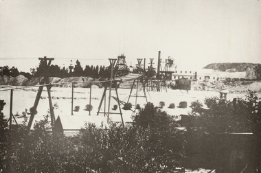
Photograph - CENTRAL BLUE MINE, 1912
Black and white photo: mine site with poppet head, mine buildings at rear right . Trestles and cables carrying rectangular bins across open land. Large mound of material behind main building. Trees and weatherboard building in foreground. On back written in ball point pen and underlined ' flying Fox' Central Blue Mine to Crushing Battery 1912 'mine, gold, central blue, bendigo, mines and mining, surface equipment, place, mining, surface equipment, flying fox, poppet head -
 Bendigo Historical Society Inc.
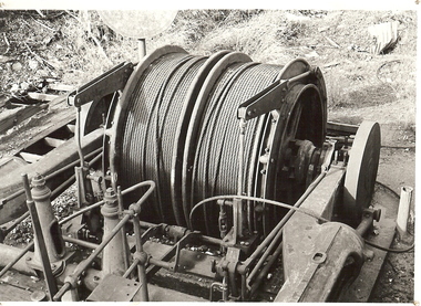
Photograph - WINDING ENGINE AT MONUMENT HILL MINE
Black and white photograph of a winding engine (Roberts & Son) at Monument Hill Mine. Winding gear, large drum with wire cable wound on, sitting on concrete base. Inscriptions: on back - lined paper, glued in centre 'Monument Hill Mine, Winding Engine, Roberts and Sons'.place, mining site, rope winding drum, mines and mining, equipment, mining equipment, bendigo, mines, mining, surface equipment -
 Bendigo Historical Society Inc.
Photograph - CEMETERY - BENDIGO - MINERS' CEMETERY
Photograph - 'AMBROTYPE' which is imaging a negative on glass backed by a dark surface. A photo of graveyard with picket fences around grave sites, three men standing in the background, one building in the distance. Photo is in a leather bound box, two clips, open it up, has red velvet in case, glass over ambrotype photo..place, cemetery, cemetery, cemetery. bendigo area. ambrotype photo. -
 Bendigo Historical Society Inc.
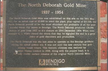
Photograph - NORTH DEBORAH GOLD MINE BENDIGO MINING PLAQUE
Metal plaque, gold writing, erected at the site of the former North Deborah Gold Mine when the brick chimney was restored by Bendigo Mining NL. The plaque reads: 'The North Deborah Gold Mine, 1937-1954. The North Deborah Gold mine was established on this site on the 28th May 1937. For an initial cost of 2,000 pounds to erect the plant, plus capital of 37,500 pounds, the North Debnorah proved to be the most abundant and profitable of all the post Second War mines in Bendigo. The North Deborah produced 128,000 ounces of gold from 1937 to its closure on 23rd December 1954. When mine manager E.J. White closed the doors that day he signaled the end to a great story of gold discovery and production. The North Deborah was the last mine to operate on the Bendigo goldfield during the initial golden era. It was not until the new century that gold mining would return. This historic chimney was restored by Bendigo Mining Limited in 2006. Along with the poppet head. It is the only visible surface remains of the original North Deborah Mine.' The mine site is situated off Breen Street in Golden Square.Kay MacGregor 2012bendigo, mining, north deborah mining company -
 Bendigo Historical Society Inc.
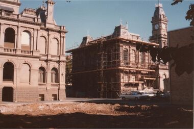
Photograph - LAW COURTS AND POST OFFICE BUILDING, BENDIGO
Colour photo: taken from rear of Law Courts and Post Office buildings, which are situated in Pall Mall Bendigo. Demolition site where Police Headquarters once stood in foreground, fully cleared with dirt surface evident. Post Office building rear and side covered in scaffolding.organisation, government, law courts, post office -
 Bendigo Historical Society Inc.
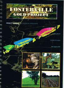
Document - FOSTERVILLE GOLD MINE COLLECTION: PROJECT UPGRADE TECHNICAL APPENDICES
Black cover book, wire binding. Pages in reports numbered individually, overall approx 250 page report. On front: "Fosterville Gold Project' Project upgrade, EES Technical Appendix B. Central North, Central Ellesmere, Harringtons Hill." Page 1 'Perseverance Exploration Pty Limited' Book contains technical appendices. Topics: hydro geological assessment; surface drainage study, noise emission to residential properties, flora survey, tailings dam site; flora survey Wellesford Forest; Daley's Hill Plant List; diurnal Avifauna Survey - Wellesford Forest; survey of vertebrate fauna - Wellesford Forest; brief summary of fauna - Daley's Hill, Axedale, Aboriginal Archaeological survey; archaeological investigation Fosterville; traffic survey - Fosterville Sulphide Project; traffic report.bendigo, mining, fosterville gold mine -
 City of Ballarat
Artwork, other - Public Artwork, Cliff Burtt, Buninyong Bivium, 2016
Buninyong Bivium (2016) by Cliff Burtt engages with the geography and history of the Buninyong region in both pre and post settlement. The town of Buninyong is dominated by the profiles of Mt Helen and the extinct volcano Mt. Buninyong. Traditional land of the Wadawurrung people, today the area remains a significant site for the culture of indigenous people and their connection to the land. The profile of this sculpture is based on topographical mapping of the area, depicting sections of the landscape. The gaps between the elements of the work can be viewed as representations of the shafts sunk into the earth by the early gold miners and compound curves on the upper surfaces are mirroring the topography of the area, while cut-aways in the sides are suggestive of rock strata.The artwork is of aesthetic and social significance to the people of BallaratCorten steel sculpture made of five unique sculptural pieces secured to at concreate base at pavement levelbuninyong, cliff burtt, sculpture, public art, mining, ballarat -
 Hume City Civic Collection
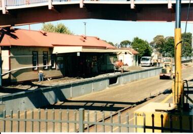
Photograph, 21/04/2005
This photograph was taken during the upgrade of the Bendigo Railway line at Sunbury Station. The upgrade took twelve months to complete and during that time buses replaced the trains.A coloured photograph of construction on the site of the Sunbury Railway Station. The photograph was taken from the Bendigo platform and shows the concrete wall which replace the bluestone foundations on the Melbourne side of the station. A workman is on the platform working on the new surface.railways, bendigo line, railway stations, bridges, sunbury railway station, george evans collection -
 Mt Dandenong & District Historical Society Inc.
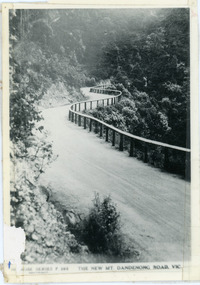
Photograph, The New Mt Dandenong Road, Vic
Copy of Rose Series postcard #385 showing the new Mt Dandenong Tourist Road with wooden railing fence on low side of road. Surface not yet made. This photograph has a detailed inscription on the back handwritten by John Lundy-Clarke in 1974.View downhill from the Windy Bend showing the site of the 1972 landslide. In this picture the road is running along the top edge of the wall 900’ thick of Kalorama Docite that plunges thousands of feet deep down into the earth below the Ranges and extends to Fern Tree Gully. It was once a horizontal terrace nearly ten miles square and tipped over to the left when the mountain subsided into its volcanic cauldron.mt dandenong road, rose series, windy bend, landslide -
 Bayside Gallery - Bayside City Council Art & Heritage Collection
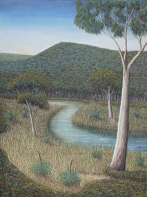
Painting - oil and acrylic on canvas, Robert Kelly, Chinaman's Creek, 2016
Bob Kelly paints landscapes of culturally significant sites along the Mornington Peninsula and depicts these locations as he imagines they originally were before colonisation. Using traditional Western painting techniques, Kelly records the underlying spirit of the Peninsula from a Wathaurong perspective. Chinaman’s Creek in Capel Sound (Rosebud West) was an important watercourse that originally ran from Wonga (Arthur’s Seat) down through Tootgarook Swamp into Port Phillip Bay. It was a great fresh water and food source and home for many Boonwurrung people. Since settlement over 170 years ago, the creek has been drained, blocked, reconstructed and damaged. Kelly depicts a lush green landscape in which the clean creek water winds through the surrounding vegetation of spinifex grasses and gum trees, the background hills are abundant with trees, untouched from man's intervention. Using painstaking detail, Kelly records each blade of grass and ripple on the surface of Chinaman’s Creek. His attention to detail serves to powerfully reimagine this important cultural site, returning it to its former pristine state, and reinvigorating its role as a key place of sustenance for the Indigenous populations of the Peninsula. Chinaman's Creek was a finalist in the 2017 Bayside Acquisitive Art Prize.oil and acrylic on canvaslandscape, creek, trees, chinaman's creek, painting, indigenous, robert kelly, bayside acquisitive art prize, bob kelly, wathaurong, rosebud, arthur's seat, tootgarook swamp, port phillip bay, boonwurrung -
 Bendigo Historical Society Inc.
Photograph - Big Deborah Mine, Bendigo
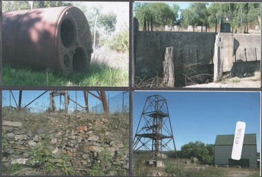
The Big Deborah Mine situated in Abel Street, Bendigo, operated from 1860 to 1952, producing 51,935 ounces of gold.Six colour photographs of the surface assets at the Big Deborah Mine, Bendigo; date circa 2016. Mine assets remaining on site at Big Deborah Mine, Bendigo.big deborah mine, machinery -
 Bendigo Historical Society Inc.
Souvenir - Photographs: Central Deborah Mine
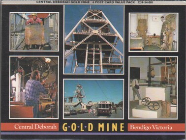
The Central Deborah Mine closed it's mining operations in 1954. The complete nature of the site encouraged the Bendigo City Council to purchase the site in 1970 in order that it be preserved. In 1971 the Bendigo Trust was formed and under its auspices the surface was opened to tourists in 1971' Extensive work enabled Level 2, underground to be opened to the public. This was followed in 1998 by Underground Level 3 Adventure tours. In 2011 visitors were able to tour as far down as Level 9, 228 meters below ground making it the deepest underground mine tour.Concertina souvenir six photographs of mining at Central Deborah Gold Mine Bendigo Victoria. Could be broken up to send as six separate postcardspostcards, central deborah mine -
 Glen Eira City Council History and Heritage Collection
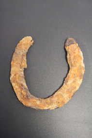
Horseshoe
The horseshoe was found during excavating the site for the development of GESAC, East Boundary Road, Bentleigh. Iron horseshoe, U-shaped, dark and corroded with concretion / accretion of rusty coloured debris over much of the surface.No legible inscriptions. -
 Stawell Historical Society Inc
Archive - CD/DVD, Gold Mining Relics of the Past - Surface and underground. Plan view of underground mine. Photographs of various mine sites. Underground workings of various mines, 2003
stawell, mines, relics, stokes, timbers -
 Parks Victoria - Wilsons Promontory Lightstation
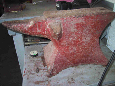
Anvil
As quoted from Wikipedia, ‘An anvil is a block with a hard surface on which another object is, struck. The block is as massive as it is practical, because the higher the inertia of the anvil, the more efficiently it causes the energy of the striking tool to be transferred to the work piece’. The lightstation’s anvil is a red-painted iron block with a conical beak or horn at one end that was used for hammering curved pieces of metal. It would have stood on a heavy free-standing pedestal, such as a large tree stump, to allow complete access to the item being hammered. Some anvils display the manufacturer’s name in the metal on the side, but this is not the case here, and its age, although unknown appears to be quite old, perhaps c.1900. It appears to have had a lot of use, and although no record of this survives, it is presumed that a forge operated on site for hammering, cutting, shaping and repairing tools such as bolts, nails, hooks, chain segments, pulley blocks, hinges, crow bars, picks, chisels, horseshoes and harness hardware. A hames hook (which forms part of the collar worn by a draught horse) survives at the lightstation as do many other heavy metal tools and pieces of equipment. The anvil is an example of the necessary resourcefulness and self sufficiency practiced by lightkeepers working and living in a remotely located workplace and home, and many of the iron items in the collection may have been repaired or even made on its working surface. As a lightstation manager Chris Richter used the anvil to manufacture pulley blocks for sash windows, repair brass door hinges & sharpen cold chisels, crowbars and picks and other lightkeepers have used this anvil for many fabricating jobs such as manufacturing ducting for the generator room ventilation system."The lightship only came in every three months with supplies and there would have been repairs to do between visits from a blacksmith - who would have had to travel on the ship. Also, the ship was only anchored in the bay long enough to unload supplies and collect and deliver lightkeeping staff – probably not enough time to get much smithy work done – especially if the weather packed it in and the ship had to depart. Lightkeepers in our time had to be self sufficient, resourceful and innovative and I imagine that would have been the case in the past." It has second level contributory significance.Red painted blacksmith's anvil. -
 Parks Victoria - Gabo Island Lightstation
Anemometer
This device was used to measure surface wind speed and direction. This anemometer was located on a concrete pad outside room 2.15 on a steel pole. The pole was considered unsafe and the anemometer was relocated to it's current position. When lowering the pole it fell over and was badly damaged. The Bureau of Meteorology donated it to the museum. It was then repaired and restored. The central pole on which it is mounted is galvanised iron pipe painted black. The anemometer, a portable device that manually measures wind speed, was a necessary instrument once common to all weather stations. The arms are attached to a vertical rod and as the wind blows, the cups rotate, making the rod spin. The stronger the wind blows, the faster the rod spins. The anemometer counts the number of rotations, or turns, which is used to calculate wind speed, surface wind and direction. They were designed to be durable to withstand the corrosive environment and strong winds expected at coastal sites such as those at Gabo Island. Anemometers existed in the nineteenth century and their design was improved by various experts including John Robinson in 1846, John Patterson in 1926, Brevoort and Joiner in 1935 and Derek Watson in 1991 who added wind direction measurement to its functions. This example was made for the Bureau of Meteorology by the Melbourne instrument company, Synchrotac, which became registered and incorporated on 26 July 1966. It is now displayed inside the building. A good example of its kind, the anemometer has first level contributory significance for its historic value and provenance to the lightstation.Anemometer and tripod stand. Three cupped brass discs on rotating arms fixed to turned brass cylinder shaped shaft. Beneath discs is a lead directional wind arrow attached to a rotating arm. A wooden three legged stand with central supporting pole of black painted hardwood and attached to a white painted marine ply circular base.Under wind cups: " SYNCHROTAC / MELB. / ser.no.70/372 / MADE IN AUSTRALIA." Above wind direction arrow: "C.OF.APT..../ SYNCHROTAC / MELB ? MADE IN AUSTRALIA / ser.no.70/372" -
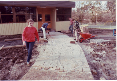 University of Melbourne, Burnley Campus Archives
Photograph - Colour print, James (Jim) Pleasance, Students Building Brick Paths Around Relocatable Buildings, 1985
Note in paper catalogue, "Hard surfacing the pathways around the new relocatable buildings erected on the site of the old Lagoon fill (completed 1977). Students completed most of the work with the central garden area designed by Californian exchange staff member Steve Mullany, 1985." 2 similar colour photographs. Students building brick paths around relocatable buildings in the Quad. On reverse, "13.Sep.1985," and, "Hard surfacing with brick.hard surfacing, bricks, pathways, students, gardens, californian exchange, staff, steve mullany, quad, relocatable buildings, students working outside -
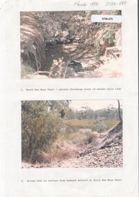 Bendigo Historical Society Inc.
Photograph - Kangaroo Flat Gold Mine Collection: Deadhorse Gully, Sydney Flat Creek March 1986
Colour photographs, seventeen images on nine page. Images labelled as follows : 1. North New Moon shaft - natural discharge point of Garden Gullly line 2. Actual exit to surface from beneath mullock at North New Moon shaft. 3. Looking into Deadhorse Gully from mullock heap at North New Moon site. 4. Deadhorse Gully downstream of WMC Weir. 5. Sydney Creek track crossing - impassable ford. 6. Sydney Creek looking downstream from ford. 7. Sydney Creek looking upstream from road near Recreation Reserve (12 inch pipe under road). 8. Sydney Creek looking downstream from same point. 9. Sydney Creek - Camp Road, looking upstream.. 10. Sydney Creek - Camp Road, looking downstream. 11. Sydney Creek - Camp Road Culverts. 12. Sydney Creek - Pyramid Road Bridge, looking upstream. 13. Sydney Creek - Pyramid Road Crossing looking downsteam. 14. Sydney Creek - rail crossing, looking upstream. 15. Sydney Creek - rail crossing, looking downstream. 16. Sydney Creek - Airstrip road, looking upstream. 17. Sydney Creek - Airstrip Road, looking downstream 12 inch pipe under road. Lined paper, in blue pen 'Deadhorse Gully-Sydney Flat Creek, March 1986, Photos of Deadhorse Gully/Sydney Flat Creek'kangaroo flat gold mine, deadhorse gully, sydney flat creek, unity mining, water discharge, north new moon, camp road, pyramid hill road, eaglehawk -
Villa Alba Museum
Document, Villa Alba Museum Archaeological Test Excavations, 2002
A preliminary report on archaeological test excavations, conducted on 5 & 7 September 2002 by Maddy Atkinson (Ripple Arc). The purpose of the excavations was twofold. Firstly, to conduct subsurface testing at Villa Alba to determine the presence, location and depth below ground of archaeological remains relating to a number of landscape features identified in historical plans, photographs, survey field books and aerial photographs. Secondly, soils surrounding the Villa Alba mansion, which have been found to be contaminated with lead will need to be removed up to a depth of up to 0.6 metres. Removal of deposits from the site may have an adverse impact on any archaeological remains existing below the surface.Contents: Acknowledgements / Abbreviations / List of figures / List of tables / List of plates / Introduction / Historical context / Methodology / Results and interpretations / Discussion / Recommendations / References / Appendix 1 - Plates / Appendix 2 - Content list / Appendix 3 - Copy of Heritage Victoria permit.non-fictionA preliminary report on archaeological test excavations, conducted on 5 & 7 September 2002 by Maddy Atkinson (Ripple Arc). The purpose of the excavations was twofold. Firstly, to conduct subsurface testing at Villa Alba to determine the presence, location and depth below ground of archaeological remains relating to a number of landscape features identified in historical plans, photographs, survey field books and aerial photographs. Secondly, soils surrounding the Villa Alba mansion, which have been found to be contaminated with lead will need to be removed up to a depth of up to 0.6 metres. Removal of deposits from the site may have an adverse impact on any archaeological remains existing below the surface. conservation studies, conservation reports, archaeological reports, villa alba museum -
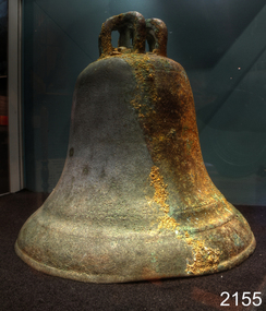 Flagstaff Hill Maritime Museum and Village
Ceremonial object - Church Bell, Before 1855
This artifact is a large brass bell. It was retrieved from the Schomberg wreck by local divers in the 1970s. Its location at the wreck site was described as "found on the west side towards the stern" the vessel remains lying on a north-south axis, with the bow pointing towards the shore as a result the bell was assessed from this position to have formed part of the cargo. The view that this was not a ship's bell belonging to the Schomberg is gained from two other 'Schomberg Bells' in the Flagstaff Hill collection, both of which have the vessel's name prominently etched into their outer surface. Additional indications indicate that this bell was not intended for maritime use due to the bell's rounded 'bell-curve' shape suggesting it was melodically tunable. Also the detailed basket-type fittings on the bell dome that would allow the bell to be suspended by ropes rather than just bolted to a yoke. The bell is currently on display at Flagstaff Hill, categorised as a church bell part of the Schomberg's cargo that was intended for use in a church within the Victorian colony. As the Colony of Victoria became more established, and its population expanded with the Gold Rush and other emigration from Britain, the demand for regular religious services and permanent church buildings also grew. We will never know if this bell was a specific order or part of an enterprising bell founder's consignment of general stock to a wholesale supplier in Melbourne. A cargo manifest for the Schomberg has unfortunately never been found. The shipwreck of the Schomberg is regarded as of significance to Victoria and is registered on the states Heritage list (S 612). The Schomberg wreck has great historical significance as a rare example of a mid 19th century large, fast clipper ship intended to transport cargo and passengers between England and Australia. The vessel that carried this bell represents the marine advances made in an attempt to break established sailing records between Europe and Australia. Flagstaff Hill holds a noteworthy collection of artefacts from the Schomberg shipwreck. The collection as a whole is primarily significant because of the relationship the objects have archaeologically, not only to highlight the story of the Schomberg ship and later it's wrecking but have an important potential to interpret the story and progression of maritime shipping in the 19th century. The church bell has a standard bell-curve shape and is dull bronze in colour. A large brass bell, plain and without visible maker marks, but with traditionally intricate basket-type cast fittings for suspension from a yoke by a number of ropes or chains. Approximately 3/8 of the bell’s outer surface bears a thin layer of marine growth and limestone accretion, and there is some minor pitting and spots of light verdigris over the remainder. The bell mouth, or lip, is slightly compressed-in in two places. It was retrieved from the wreck of the Schomberg. warrnambool, flagstaff-hill, flagstaff-hill-maritime-museum, maritime-museum, shipwreck-coast, flagstaff-hill-maritime-village, schomberg, shipwrecked-artefact, clipper ship, black ball line, 1855 shipwreck, aberdeen clipper ship, captain forbes, peterborough shipwreck, ss queen, brass bell, church bell -
 Bendigo Historical Society Inc.
Photograph - Victoria Hill, Bendigo, 1973
Gold was discovered on Victoria Hill in 1854 and by 1861, 1,200,000 ounces of gold had been extracted from the site. The first claim was bought for 80 pounds by Prussian immigrant Christopher Ballerstedt and his son Theodore. Christopher Ballerstedt was nicknamed the "Father of the Hill" and was the first to prove that gold reefs extended below the surface. His 200-foot plus mine shafts yielded quartz rich with gold, inspired other miners, and were instrumental in Bendigo becoming the world's deepest and richest goldfield. The site still features relics of nineteenth century mining including quartz crushing machinery and the foundations of George Lansell’s 180 mine. These features are characteristic of Bendigo’s mining history and represent two prominent nineteenth century miners, Christopher Ballerstedt and George Lansell, who held important roles in the development of Bendigo. Victoria Hill Quartz Gold Mines are registered as a site of significance. The site is of historical, archaeological and scientific importance to Victoria. The mines represent the symbolic heart of Bendigo’s gold mining history and the importance that mining played in wealth creation and the development of Victoria. The diggings reserve is accessed from the rear of Albert Richardson Reserve located at 40-56 Marong Road, Ironbark. The site has steep and unformed paths and is closed to the public at dusk. It is important to stay to the paths to avoid the diggings. Interpretive signs help visitors to appreciate the importance of the site and the remaining relics of Bendigo’s mining history.Victoria Hill Ironbark, Bendigo. Photos of the poppet head, sand heap, tailings, shafts and tunnels. Before development into a tourist attraction.history, bendigo, victoria hill, ironbark, diggings -
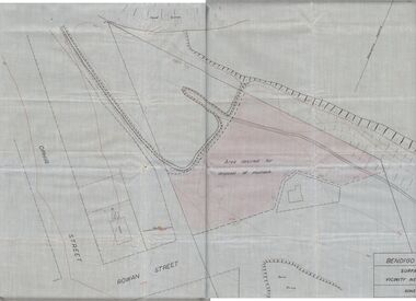 Bendigo Historical Society Inc.
Plan - MCCOLL, RANKIN AND STANISTREET COLLECTION: PLAN OF MONUMENT HILL BATTERY
Pale blue waxed paper plan. Written on back of plan ' Monument Hill Battery site, area desired by Bendigo Mines (Nell Gwynne) for disposal of mullock. Plan shows Ophir Street, Rowan Street, Written on bottom RH corner 'Bendigo Mines Ltd., surface plan, vicinity Nell Gwynne Shaft, Scale 1" = 40' Magnetic north marked, sand dumps and contour lines.bendigo, business, mccoll, rankin & stanistreet