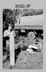
Showing 137 items matching "survey locations"
-
 Bendigo Military Museum
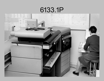
Photograph - Orthophotomap Workstation, Lithographic Squadron – Army Survey Regiment, Fortuna, Bendigo, 1988
... locations. Royal Australian Survey Corps RASvy Army Survey Regiment ...This collection of four photos was most likely taken at Lithographic Squadron, Army Survey Regiment, Fortuna, Bendigo in 1988. Orthophoto mapping provided the Survey Corps with the capability to produce map products quickly in the event of a crisis. These are four photographs of equipment used by the Army Survey Regiment to produce orthophotomaps. The OR1 orthophoto projector and workstation was introduced in the mid-1980s. It was the second-generation equipment used to orthorectify colour and monochrome film aerial photography, replacing the system introduced in 1973. Orthorectification is the process of removing geometric distortions and scale errors/variations from images. Images have tilt and relief distortions that make it difficult to compare accurately a map and an image of the same geographic area. Once an image is orthorectified, features on the image are shown in their planimetric locations. These four photographs of orthorectification equipment in operation were taken at the Army Survey Regiment at Fortuna, Bendigo, 1988. The photographs were on 35mm negative film and were scanned at 96 dpi. They are part of the Army Survey Regiment’s Collection. .1) to .4) - Photo, black & white, 1988, WILD OR-1 Orthorectification Workstation, SPR Carmel (Butler) Fauth.No personnel are identifiedroyal australian survey corps, rasvy, army survey regiment, army svy regt, fortuna, asr, litho -
 Bendigo Military Museum
Photograph - Lithographic Squadron Regimental Training, Army Survey Regiment, Bendigo, 1989
This is a set of 24 photographs of Army Survey Regiment’s Lithographic Squadron personnel undertaking regimental training in an unknown location in April 1989. The purpose of the training was probably to provide personnel a practical knowledge of navigation and map reading, RATEL and Survival in the Field, vehicle camouflage, teamwork and leadership. The training did not include infantry and minor tactics due to the absence of weapons. Although these photos are not annotated other than the month and year, most personnel are positively identified.This is a set of 24 photographs of personnel from Lithographic Squadron, Army Survey Regiment, Fortuna, Bendigo, undergoing regimental training in April 1989. The photographs were on 35mm negative film and scanned at 96 dpi. They are part of the Army Survey Regiment’s Collection. .1) - Photo, black & white, 1989, background L to R: Frank Lenane, Bill Jones, foreground L to R: Gavin McLean, Colin Yeats, Peter Dillon. .2) - Photo, black & white, 1989, Rhys De Laine. .3) - Photo, black & white, 1989, L to R: Peter Breukel, Colin Yeats. .4) - Photo, black & white, 1989, L to R: Colin Yeats., Peter Dillon. .5) - Photo, black & white, 1989, L to R: Graeme Spong, Gavin McLean, unidentified (x2), Peter Breukel, Steve Burke, Bill Jones, Colin Yeats. .6) - Photo, black & white, 1989, L to R: Graeme Spong, Bill Jones, Colin Yeats, Peter Dillon, Peter Breukel, Steve Burke, Colin Yeats. .7) - Photo, black & white, 1989, L to R: Graeme Spong, Bill Jones, Colin Yeats, Peter Dillon, .8) - Photo, black & white, 1989, Colin Yeats. .9) - Photo, black & white, 1989, L to R: Gavin McLean, Colin Yeats. .10) - Photo, black & white, 1989, L to R: Steve Burke, Peter Breukel, Colin Yeats, unidentified. .11) - Photo, black & white, 1989, L to R: Steve Burke, Peter Breukel. .12) - Photo, black & white, 1989, L to R: Peter Breukel, Steve Burke. .13) - Photo, black & white, 1989, Craig Hersant. .14) - Photo, black & white, 1989, L to R: Rob Bogumil, Darren Maher, Paul Baker, Rob Jones, Shona Hastie, unidentified, Chad Hardwick. .15) - Photo, black & white, 1989, L to R: Chad Hardwick, unidentified, Rob Bogumil, Rob Jones, Darren Maher, unidentified, Paul Baker. .16) - Photo, black & white, 1989, L to R: Rob Bogumil, Darren Maher, Chad Hardwick, Rob Jones, unidentified (x2), Paul Baker. .17) to .22) - Photo, black & white, 1989, unidentified personnel applying camouflage to truck. Shona Hastie in truck, .23) - Photo, black & white, 1989, L to R: LT Dave Weston, LT Craig Hersant, Trevor Osborne, Bill Jones. .24) - Photo, black & white, 1989, L to R: Andrew Arman, unidentified, Peter Dillon, Steve Burke, Colin Yeats, Peter Breukel. No personnel are identified. Annotation dated April 1989.royal australian survey corps, rasvy, army survey regiment, army svy regt, fortuna, asr, litho -
 Bendigo Military Museum
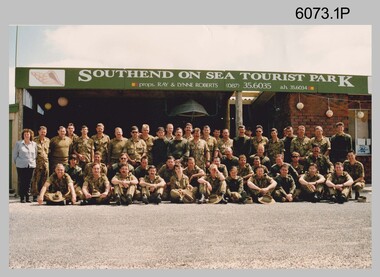
Photograph - Group Photos of Lithographic Squadron, Army Survey Regiment, c1990s
These three photographs of Lithographic Squadron were taken in the 1990s. Photos .2P and .3P were taken at the Army Survey Regiment, Fortuna, Bendigo. .1P was taken as the background sign indicates, at the Southend on Sea Tourist Park, close to the township of Millicent in South Australia. Lithographic Squadron was in this location probably as part of Regimental or Adventurous Training in 1992.This is a set of photographs of Lithographic Squadron, Army Survey Regiment, Bendigo c1990s. The photographs were printed on photographic paper and are part of the Army Survey Regiment’s Collection. The photographs were scanned at 300 dpi. .1) - Photo, colour, 1992, Lithographic Squadron .2) - Photo, colour, 1991, Lithographic Squadron .3) - Photo, colour, Sep 1993, Lithographic Squadron.1P and .2P - annotated on back with date .3P – annotated on front with dateroyal australian survey corps, rasvy, army survey regiment, army svy regt, fortuna, asr, litho -
 Federation University Historical Collection
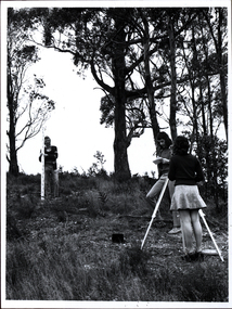
Photograph - Black and white photograph, Surveying Exercise
Two men, and a woman wearing a mini skirt undertake a surveying exercise in a bush location. It is thought to be land near the Mount Helen Campus.surveying, mount helen, mini skirt, platform shoes, desert boots, scientific instruments, student activities -
 Bendigo Military Museum
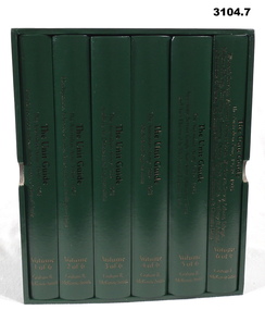
Book - BOOKS, BOXED SET OF 6, Graham R McKenzie - Smith, The Unit Guide, 2018
Boxed set of 6 books. The Unit Guide, The Australian Army 1939 - 1945. .1) Box, open, cardboard, dark green buckram, white paper lining, gold print on sides. .2) - .7) Hard cover book, cardboard, dark green buckram with gold print on front cover & spine. Pages plain cut, black print, black & white illustrations. .2) 483 pages. .3) 605 pages. .4) 626 pages. .5) 654 pages. .6) 706 pages. .7) 568 pages..2) Volume 1 of 6. Unit & Location Indexes, Bibliography, Orders of Battle .3) Volume 2 of 6. Headquarters, Infantry, Cavalry, Armoured & Intelligence Units. .4) Volume 3 of 6. Artillery, Air Defence & Engineer Units. .5) Volume 4 of 6. Medical & Signals Units. .6) Volume 5 of 6. Aust Army Service Corp, Aust Army Ordnance Corp & Aust Electrical & Mechanical Engineer Units. .7) Volume 6 of 6. Women's Services, Volunteer Defence Corps, War Graves Survey, Labour Salvage, Military Policing, Recruiting & Training, Dental, Bath & Laundry, Veterinary & Animal, Movements & Transit, Pay, Records & Printing & Postal, Amenities & Canteens Units.books-military-history, units, 1939 - 45 -
 Wycheproof & District Historical Society Inc.
Bunguluke Map, Bunguluke District In 1923, 27.2.1923
By 1881 Bunguluke was a small settlement as recorded, December 5, in the Charlton "Mercury". It reports that in that year Draper's Store, Hotel and Post Office and residence at Bunguluke North was totally destroyed by fire. For years now there has been little sign of community life with houses few and far between and acreages have gone into larger holdings. The map references land blocks and owners for that era.This important map shows the local land ownership and local features that existed in 1923. This is a photocopied black and white map of Bunguluke in the County of Kara Kara, Number L5149. Marked - Photo Lithographed by W.J. Butson 27.2.1923. The details include numbers of allotments, property owners, roads, rivers. The boundaries marked are the Parish of Jeruk, Parish of Wycheproof, Parish of Cooroopajerrup. Wycheproof township location is shown with the Scale of Chains. Bunguluke maps for other years are also in the collection.map, bunguluke, jeruk, wycheproof, cooroopajerrup -
 Glen Eira Historical Society
Document - CAULFIELD RSL
This file contains two items pertaining to the property housing the Caulfield RSL: 1/A photocopy (2 pages) of an assessment of the property, dated 01/1997, by Andrew Ward, for purposes of ascertaining its historical significance. The assessment describes the architectural features of the property, offers a brief history of it, specifies why it should be considered significant, and recommends that it be added to the National Estate Register. Included is a black-and-white photograph of the exterior of the building. 2/An assessment (17 long pages plus appendix) of the car parking issues procured as a result of the decision to refurbish the Caulfield RSL. Prepared by Grogan Richards Pty Ltd, dated 13/11/2002, reviewed by Joanna Gauetty, and authorised by Rody Jude. Included is a description of the Club’s location and surrounding motorways as they existed at the time, a description of the Club itself (eg its opening hours and rate of patronage as per each opening hour), occupancy surveys, descriptions of other recent car parking construction within the same area, a description of the extensions the RSL is aiming to construct, and descriptions of the considerations any new construction must take into account. Included is a black-and-white map of Caulfield noting the RSL’s location, and two black-and-white photographs showing the view to the north and south of St. George’s Road, respectively.caulfield, caulfield returned servicemen league (rsl), exservice organisations, clubs and associations, ward andrew, glen eira heritage management plan, historic buildings, architectural, styles, national trust company, st. leonard’s, elsternwick club, grogan richards pty ltd, returned servicepeople, armed forces, soldiers, aged people, senior citizens centres, st. george’s road, elsternwick, english domestic revival style, moderne style, brick houses, bay windows, architectural features, prendergast ellen mrs., ford grylis, dl design group, gauetty joanna, jude rody, parking, glen eira planning scheme -
Federation University Historical Collection
Booklet - Document, Robert Ashley et al, 'The Lal Lal Iron Tramway', 1970
High on a series of terraces overlooking the Moorabool River stands the remains of the Lal Lal Blast Furnace, classified 'A' by the National trust (to be preserved at all costs). This was the location of Victoria's only pig iron industry. A series of tramways served the works, as a well surveyed narrow-gauge tramway connected the blast furnace with the Victorian Roailways' main line about 3.5 miles away. Light Railways, no 24, Summer 1970-71, 36 pages. This booklet considers the Lal Lal Iron Tramwaylal lal iron, lal lal blast furnace, tramways, railways, pig iron, ironstone quarry, industrial heritage -
 Federation University Historical Collection
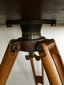
Instrument - Scientific Instrument, W.&L.E. Gurley, Plane Table
... at the Ballarat School of Mines in Surveying classes. It was used ...Used at the Ballarat School of Mines in Surveying classes. It was used in conjunction with Item 04129 - Collapsible leg surveying instrument, tripod, and at times with Item 4127 - Tripod location chains.A wooden platform used in surveying equipped with a 2.7 cm diameter dowel at each end that would hold the charts/papers in position. A spherical mount on the underside, designed to match the receptacle on top of the tripod - Item 04129.Manufacturer's stamp underneath.plane table, surveying, w. & l.e. gurley, scientific instrument, ballarat school of mines, tripod, location chains -
 Federation University Historical Collection
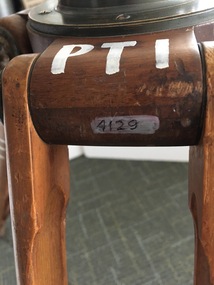
Instrument - Scientific Instruments, W.& L.E. Gurley, Collapsible Leg Surveying Instrument: Tripod
Used with the Plane Table - Item 4130, in surveying classes at Ballarat School of Mines. Item 4127, Tripod Location Chains, may also have been used.A large tripod of timber construction. Concave top mount flange to receive matching spherical spigot. Spacer block halfway up each twin-strut leg.In white paint on the top "PTI" Manufacturer's stamp on each leg - circular. "W.& L.E. GURLEYtripod, surveying, scientific instrument, ballarat school of mines, plane table, location chains, w & l e gurley -
 Federation University Historical Collection
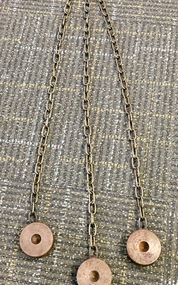
Instrument - Scientific Instruments, Tripod Location Chains
Surveying instrument accessories. Two sets. Used in conjunction with item 4129 - Collapsible leg surveying instrument, tripod. Could also be used with item 4130 - Plane Table which goes with the tripod mentioned.A set of three steel discs, connected in star configuration by three brass chains of equal length. Used to contain tripod ends on hard smooth surfaces.surveying, metal, steel discs, scientific instruments, location chains, plane table -
 Ringwood and District Historical Society
Map, Plan of Country Lands in the Parishes of Nunawading Ringwood and Scoresby - circa 1855
Blueprint copy of Survey Map detailing original Selectors' names and property locations. List of Parish map references including property bearings, distances in Links, and markings on trees. Descriptive remarks include areas marked "Farmer's Common", "Poor soil thickly/moderately timbered with stringy bark", and location of water and firewood reserves."Surveyed and plotted by N.M. Bickford, Superintendant of Mr. Hodgkinson's Field Party". "The land comprised in this survey is of inferior quality, moderately undulating, and thickly wooded. It is watered by Dandenong Creek and Deep Creek." Inset map showing location of (*proposed) cemetery on southern corner of Lillydale Road from Melbourne and Sawmill Road, later Mount Dandenong Road. (*Cemetery did not eventuate.) -
 Ringwood and District Historical Society
Map, Plan of the Parish of Warrandyte County of Evelyn - 1841
Blueprint copy of Survey Map W27 detailing original Selectors' names and property locations between Yarra Yarra River (Warrandyte) and Mullum Mullum Creek (Ringwood). List of Parish map references including property bearings, distances in Links, and markings on trees. Pound Bend area of Warrandyte marked as Reserve For Aborigines. Descriptive remarks include areas marked "scrubby, flat, sandy soil". Several other references faded and illegible.(Map) by T.H. Nutt Feb 3 1841. -
 City of Moorabbin Historical Society (Operating the Box Cottage Museum)
Photographs, 7 x B&W Circa 1918 Cheltenham Methodist Youth Group, Circa 1918 Photos of Cheltenham Methodist Youth Group, 1918
Circa 1918: Various Photos of the Cheltenham Methodist Youth Group. Row 1 and 2: "At Flinders". Row 3: 1st Left, "Holidaying at Cockatoo". in 1852 Stephen Charman, who had arrived in Melbourne 1842 aged 21 years as one of Henry Dendy's emigrants, purchased 160 acres in Spring Grove ( now Cheltenham). Stephen and his family lived in a wattle and daub hut and worked hard to establish a market garden, poultry and pig farm. The first Methodist Church Services were held at their home. In 1855 Stephen gave 1 acre of his land on Balcombe Road to the Methodist Church for a School, Burial ground and a Chapel which was built in 1857.The Methodist Church, Balcombe Road was the 2nd religious building to be erected in Spring Grove now known as Cheltenham c 18577 small black and white photographs of the Cheltenham Methodist Youth Group at Flinders, Cockatoo and unkown locations, c 1918 . First 3 photos are of male cyclists on a trip to Flinders, Victoria. Photo 4 shows 6 ladies and a man on holiday at Cockatoo in the Dandenong Ranges ,Victoria . Photos 5 to 7 show men, women and children in bushland surroundings of unrecorded locations.Photo 1 - 3 on back : Flinders 1918 Photo 4 left on back : Holiday at Cockatoo right on back : Whitehead Photo 5-7 nilcheltenham, cheltenham methodist youth group, 1914, 1918, charman stephen, gettens mary, spring grove, methodist church, charman road, balcombe road, dendy henry, henry dendy's special survey 1841, youth groups, social groups, market gardners, early settlers, pioneers, dairy farmers, poultry farmers, pig farmers,moorabbin, brighton, -
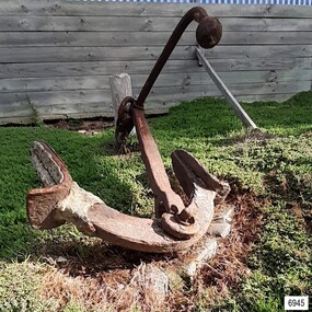 Flagstaff Hill Maritime Museum and Village
Equipment - Anchor, John Trotman, 1852 to early 1900s
This Trotman’s pattern stock anchor is the southernmost anchor on display at Flagstaff Hill’s Anchor Graveyard. This large Trotman design anchor was patented in 1852 by John Trotman and was widely used on merchant ships. On April 15th 2001 around midday this anchor was raised from the seabed of Lady Bay, Warrnambool, by the crew from Birdon Dredging, who had been hired to dredge the Harbour. The spokesperson Steve Walker, who worked for the firm, said that the anchor and long chain were found after the chain became tangled in the cutter blade of the dredging equipment. The anchor was lifted from the water and onto the Breakwater then a front-end loader placed it onto a truck that then delivered it to Flagstaff Hill Maritime Museum & Village. Howard Nichol, Museum Manager at the time, had estimated the anchor to be up to 130 years old. The previous Museum Manager, Peter Ronald, who was also a diver, had identified the anchor as a Trotman’s type and similar to those used on some of the major wrecks in the region. According to Nicholl, Museum staff believed it was possible that the anchor is one of two used as a mooring line that had been used to catch driving vessels and prevent ships from washing aground on the sand bar. The mooring line was shown as a dotted line on the 1890 chart of Lady Bay, approved by Lieutenant Stanley of the British Admiralty. by Lieutenant Stanley [British Admiralty]. The location of the anchor corresponds to a point on that map and the length of the chain supports that theory. “The map is quite a detailed survey of the Bay and it shows two anchors with buoys on the ends with probably about 100 yards of chain stretched between them. The ships would drop anchor and was the chain as a snag because this was a treacherous bay before the Breakwater was built and this was a way to eliminate that problem, "said Nichol. The mooring chain was put in place to catch drifting vessels during wild stormy weather. It was identified. ABOUT TROTMAN’S ANCHORS- The British Admiralty wanted an anchor design that had more holding power. The Committee of 1852 on Anchors was appointed to assess and report on the qualities of various anchors including Trotman’s anchors. Trotman’s pattern anchor received the highest score. The anchor is similar to the Admiral’s design but features arms that pivot when the anchor settles and the upper fluke moves to rest against the shank. The anchor then sits lower, which in turn greatly reduces the chances of the anchor’s chain, cable or rope getting tangled. The top of the shank has a fitting that allows a quick release of the anchor’s chain if this becomes necessary. This Trotman’s anchor is significant as a part of the maritime history of the Port of Warrnambool regardless of whether it belonged to one of the 29 ships that were stranded or wrecked in Lady Bay. The anchor is connected to the many attempts to maintain Warrnambool as a safe and manageable port, including the various plans for the construction of the Breakwater.Anchor: an iron Trotman’s pattern style with a rectangular-section shank that is wider in the middle and has a base that extends on two opposite sides in a ‘fork prong’ manner. A crescent-shaped, double-ended arm is fitted into the base of the shank with a bolt, enabling it to pivot. Each arm has a fluke in the shape of an upward palm with an attached metal plate that forms a horn at the back of the palm. A long, round-section pipe is fitted to the top of the shank at 90 degrees to the arms; one side has an elbow bend parallel to the arms, and both ends have an attached metal sphere. The pivoting ring at the top of the shank can be lifted for a quick release of the chain.flagstaff hill, warrnambool, maritime village, maritime museum, shipwreck coast, great ocean road, anchor, mooring, trotman, lady bay, breakwater, admiralty, ship equipment, stock anchor, john trotman, 1852 patent, 2001, birdon dredging, steve walker, howard nichol, peter ronald, british admiralty, lieutenant stanley, committee of 1852 on anchors -
 Bendigo Historical Society Inc.
Document - GOLDEN GULLY ALLUVIAL WORKINGS
Golden Gully alluvial workings, Diamond Hill area, site number 1.1. Document has map/grid references, parcel number and location - runs along Woodward Road. History from 1851 to 186 detailed. . Information from David Bannear's Bendigo goldfields survey. -
 Bendigo Historical Society Inc.
Map - STRUGNELL COLLECTION: HUSTLER'S LINE OF REEFS, September 1913
Map, Hustler's Line of Reefs, Hustler's Reef & Hustler's Reef No.1 Mines Plan.Plate No. XV1.(16) Sheet 2 .Bulletin No 33 Signed H.A.Whitelaw.Underground Survey Office, Bendigo, September,1913. Included is the emblem of the Geological Survey of Victoria. Drawing shows a plan view of reefs and shaft locations .Underground Survey Office, Bendigomap, bendigo, hustler's reef & hustler's reef 1 -
 Bendigo Historical Society Inc.
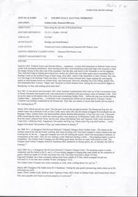
Document - LONG GULLY HISTORY GROUP COLLECTION: NEW CHUM REEF
Six pages titled New Chum Reef. No number on the first page, the others are 109 to 113. Mentions location of the reef and some of the rich mines. The mines are mentioned in a table with the Name of Mine; Depth; Production; Dates; Plant, Machinery, Comments and Position. Ballerstedt, Ashley and Noy, and Grant were three of the successful miners. Mines mentioned are: South Goldfields, New Chum Goldfields, South New Chum, Lansell's 616, South Bellevue, Eureka, Eureka Extended, New Chum Bellevue, New chum Railway, Shenandoah, North Shenandoah, Shamrock, Old Chum, Little Chum, Young Chum, Craven, Garibaldi, Ellesmere, South Old Chum, New Chum Consolidated, North Ellesmere, New Chum United, Lansell's 222, Lansell's Fortuna, Lazarus, West End, Pioneer, Old Chum, New Chum Victoria, North Old Chum, Lansell's Big 180, Sterry, Victoria Quartz, South Adventure, Great Central Victoria, Ballerstedt No 3, Adventure, Humbold, British and American, Midway, Victoria Consuls, Victoria absorbed by Ironbark, Hercules and Energetic, Victoria Pilot, North Hercules and Energetic, Great Extended Hercules, Pearl, Southern Victoria, Great Extended Victoria, Young Victoria, New Catherine Victoria, Weatern Victoria, New Victoria St Mungo, Surprise, Mystery, Duke of Edinburgh, New St Mungo, Duchess Tribute, South Devonshire, Duchess of Edinburgh, West United Devonshire, Albert, United Devonshire, Saxon and Celt, Hopewell, Prince of Wales, Phoenix, Unicorn, South St Mungo, Princess Alice, Lady Barkly, North Devonshire, Ranzeau, St Mungo, Dublin and Cornwall, Sadowa, Eastwood, Ellenborough, Belmont and Saxeby, Snobs Hill, York and Durham, La bElle, Old Williams United, Arcadia, Williams United, South Catherine, Central Catherine, Catherine United, Murchison, New Franklin, Catherine Extended, Pony Club Oval, Housing Commission, Mt Alvernia Hospital, Fortuna, Lunt, Army Survey Unit, Wybrandt, John Brown Factory, Canterbury, Hercules and Energetic and the North Red White and Blue.bendigo, history, long gully history group, the long gully history group - new chum reef, ballerstedt, ashley and noy, grant, south goldfields, new chum goldfields, south new chum, lansell's 616, south bellevue, eureka, eureka extended, new chum bellevue, new chum railway, shenandoah, north shenandoah, shamrock, old chum, little chum, young chum, craven, garibaldi, ellesmere, south old chum, new chum consolidated, north ellesmere, new chum united, lansell's 222, lansell's fortuna, lazarus, west end, pioneer, old chum, new chum victoria, north old chum, lansell's big 180, sterry, victoria quartz, south adventure, great central victoria, ballerstedt no 3, adventure, humbold, british and american, midway, victoria consuls, victoria absorbed by ironbark, hercules and energetic, victoria pilot, north hercules and energetic, great extended hercules, pearl, southern victoria, great extended victoria, young victoria, new catherine victoria, weatern victoria, new victoria st mungo, surprise, mystery, duke of edinburgh, new st mungo, duchess tribute, south devonshire, duchess of edinburgh, west united devonshire, albert, united devonshire, saxon and celt, hopewell, prince of wales, phoenix, unicorn, south st mungo, princess alice, lady barkly, north devonshire, ranzeau, st mungo, dublin and cornwall, sadowa, eastwood, ellenborough, belmont and saxeby, snobs hill, york and durham, la belle, old williams united, arcadia, williams united, south catherine, central catherine, catherine united, murchison, new franklin, catherine extended, pony club oval, housing commission, mt alvernia hospital, fortuna, lunt, army survey unit, wybrandt, john brown factory, canterbury, hercules and energetic, north red white and blue -
Bendigo Historical Society Inc.
Map - RAYWOOD GOLD FIELD MAP, 1902
Map. Raywood Gold Field Map. Linen backed map of Raywood and Neilborough Township and surrounds showing the location of varying underground workings. Surveyed by H S Whitelaw 1/6/02. It shows underground workings from The Perseverance Party and moreshed and Party and underground workings on the Old Pioneer Reef. Mentions the Parish of Yallook, Parish of Neilborough, Yarraberb, Mushroom Flat, Murray Valley Plain, Eaglehawk and Kerang Railway, Green Hill, Doughboy, Redmond's Gully, Pickpocket Lead, Raywood Lead, Inglewood Lead, Shaw's Road, Nuggety Shaft, Barkly Shaft, Maori Bendmap, gold field map, raywood gold field map, neilborough, h s whitelaw, geological survey of victoria bulletin no 12 plate 11 -
Moorabbin Air Museum
Document (Item) - Field Service Survey Macchi 000-318
Description: Macchi Defects Macchi MB326H Service Department reports RAAF various locations Level of Importance: World. -
Moorabbin Air Museum
Document (Item) - Field Service Survey Macchi Originals
Description: Macchi Defects reports From RAAF various locations Level of Importance: World. -
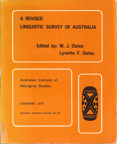 Victorian Aboriginal Corporation for Languages
Book, W J Oates, A revised linguistic survey of Australia, 1970
Lists languages under areas and language classification; records location, previous research, degree of urgency of research and assessment of total linguistic knowledge; index of variant language names.Mapslinguistics -
Whitehorse Historical Society Inc.
Map, Dandenong Ranges Area, 1956
Sheet 1. Parts of Parishes: Nunawading, Warrandyte and Ringwood. Scale: 10 chains : 1 inch. Contour intervals marked and locations of buildings.Sheet 1. Parts of Parishes: Nunawading, Warrandyte and Ringwood. Scale: 10 chains : 1 inch. Contour intervals marked and locations of buildings. Compiled from aerial photographs and cadastral survey information.Sheet 1. Parts of Parishes: Nunawading, Warrandyte and Ringwood. Scale: 10 chains : 1 inch. Contour intervals marked and locations of buildings. maps, ringwood, mitcham, warrandyte -
 Whitehorse Historical Society Inc.
Letter - Document, Roads, 1/04/1868
Letter to C. Hodgkinson, Assistant Commissioner of Lands Survey from William H. Watkins, Bailiff of Crown Lands, dated 1 April 1868 re alternative locations of road through Messrs Cook or Cummings land in Nunawading.marshall's gully, cook, william, cumming (mr), watkins, william h, hodgkinson, clement, roads and streets -
 Southern Sherbrooke Historical Society Inc.
Information folder - Glen Park
Folder containing information pertaining to the history of Glen Park homestead, Menzies Creek. Contents: -two pages photocopied from "That Little Train" by Peter Cuffley, showing four photos of Glen Park homestead and a short history of Edwin Johns at Glen Park (2 copies of each) -articles, "No. 861's full steam ahead again", photo shows Col Rees with Coonara Community School students, and "Living the dream" re. engine no. 861. On verso, "A Family Reunited", article by Emerald Tourist Railway re. locomotives, and "Colin just loves steam locomotion" re. engine no. 861. -4 letters, from Puffing Billy Railway, in support of Col Rees. -Letter, dated 19 June 1996, from Emerald Tourist Railway, re. appeal for restoration of Garratt engine. On verso, copy of certificate awarded to Col Rees for donation to appeal. -Letter, 1 June 1998, re. Garrett appeal. On verso, certificate awarded to Col & Kellie Rees for donation to appeal. -Aerial photo showing proposed property boundaries of Glen Park subdivision. -Aerial photo showing existing property boundaries of Glen Park. NB. last four items provided to society by Col Rees in support of subdivision. -Memorandum dated 2 May 2000 from Graham Whitt, Shire of Yarra Ranges, to Shire Service Centres, re proposed division of Glen Park land. -Fax, dated 13 June 2000, from Southern Sherbrooke Historical Society to Shire of Yarra Ranges, re. intention to make submission. -Letter, dated 14 June 2000, acknowledging receipt of above fax. -Submission, dated 18 June 2000, from Southern Sherbrooke HS, expressing concern re. proposed subdivision of Glen Park. -Fax, dated 27 June 2000, from Dianne Kueffer to Susan Heywood-Downard, Agenda Item 2 of the Yarra Ranges Planning Committee Agenda 14 March 2000, including detailed description of proposed subdivision and map. -Letter, dated 7 July 2000, Shire to Society, re. discussion of Glen Park subdivision by council. -Letter, dated 7 July 2000, Society to Shire, re. withdrawal of objection subject to certain conditions. -Letter, dated 14 July 2000, Shire to Society, re. council resolution to allow subdivision of Glen Park. -Letter, dated 24 October 2000, Shire to Society, stating that amendment to Planning Scheme allowing subdivision was approved by council and gazetted on 19 October 2000. -seven A3 sheets, showing house and property plans for new constructions proposed for Lot 1 of Glen Park subdivision. -diagram, hand-drawn (by Col Rees?) on lined A4 sheet, showing proposed development. -A1 sheet, Plan of feature survey of Lot 2 Blackhill Rd, Selby, dated 12 April 2000, showing contours, vegetation, proposed location of buildings, etc. -Glen Park Homestead and Cyprus Avenue, document prepared for the Shire Of Yarra Ranges by Helen Lardner Conservation & Design P/L, June 2003edwin johns, breen family, col & kellie rees, puffing billy -
 Ballarat Tramway Museum
Book, E.D. Jenkins and Lloyd Jenkins, "Sebastopol Victoria - A Historical Survey of Early Sebastopol - 1864- 1964", 1989
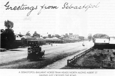
Book - 92 pages plus card covers, a historical survey of the Sebastopol district. Originally written by E.D. Jenkins for the Borough of Sebastopol's centenary in 1964, reprinted with additional text by Lloyd Jenkins to recognise the 125th anniversary of the Borough covering the years 1965 to 1989. Book covers mining history, churches, the Borough Council, early days of the district and various points, eg cabmen, horse trams and electric trams, schools, the Mechanics Institute, various clubs, fire brigade, hotels, industries, and programme of events to celebrate the centenary. The second part of the book, covering the period is laid out in a chronological order with forward by Cr. Donald, the Mayor with many photographs. Centre page has a large map of the district showing the many mines, leads, roads and other historic locations. Tramway photos are horse tram No. 7, ESCo 17 at depot (all on file) and a photo showing a horse tram heading north along Albert St. with the shopping centre in the background - see image. Photo taken just after the tram has crossed the roadway. Copy of the horse tram heading north along Albert St. made Oct. 2001 for the "gold, Gold GOLD" temporary exhibition - colour laser print onto card, with Velcro dots on rear. Stored in box D1 (Display Box) 02/2003. See Reg Item 3883 for another print of this photograph.On page 3 in black ink "Ballarat Tramway Museum Inc. With compliments, D.L. Jenkins 14/4/1999"trams, tramways, sebastopol, local history, public transport, mining, horse trams, esco -
Bendigo Historical Society Inc.
Plan - SANDHURST BOYS CENTRE SITE PLANS: LISLE STREET UNITS
16 Working drawings including Floor Plans and Elevations Prepared by Michael DeVincentis, Architects; Wellington St Strathfieldsaye. October-November 1995. Scale 1:200. No 9538. Also Survey Plan for Lot 69D 3950 Sq m. Location unknown 16.02.2023.plan, bendigo, institutions, victoria. department of planning and development -
 Queenscliffe Maritime Museum
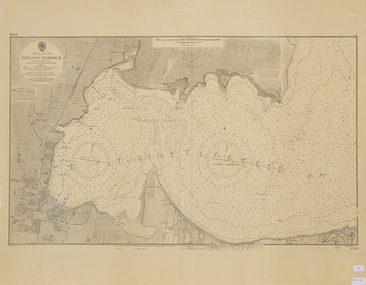
Map - Chart of Geelong Harbour, Geelong Harbour
When Hamilton Hume and William Hovell arrived at the bay in 1824 they met with the local Wautharong people who referred to the bay as "Jillong" and the surround land "Corayo", but by the time the area was surveyed in the late 1830s the Aboriginal names had been swapped. The names "Corayo" and "Jillong" had since been Anglicised to "Corio" and "Geelong".Corio Bay is an important harbour and leisure location in the West and continues to attract development such as the new Tasmania Ferry Terminal.An Admiralty Chart of Geelong Harbour revised in 1954Geelong Harbour Map Ref: 2731geelong, corio, admiralty charts -
 Bendigo Historical Society Inc.
Document - NEVILLE KING COLLECTION: OCCUPATION CERTIFICATE HOMESTEAD FARM NO. 15/939 IN THE NAME OF DAVID WILLIAMS AT A COST OF ONE POUND, DATED 25 SEPTEMBER 1897, 1897
Under the Western Australia 'the Homestead act 1893' an Occupation Certificate, Homestead Farm No. 15/939 for David Williams of Bendigo for 160 acres (near Woolkabunning near Bunbury WA); at a cost of one pound. Signed by order of the Commissioner of Crown Lands. Dated 25 September 1897. The land is marked and distinguished in the maps and books of the Department of Lands and Surveys of the said (WA) Colony as Williams Location No. 702. -
 Ballarat Tramway Museum
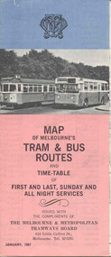
Map, Survey and Mapping for MMTB, "Map of Melbourne's Trams and Bus routes and all night services", Jan. 1967
Fold out sheet coloured map, 12 portions or folds, - title - "Map of Melbourne's Trams and Bus routes and all night services" map shows trams lines, route numbers, terminal points, bus routes, railway lines, blow up of city area with places of interest and key. On rear details, places of interest, suburb index, index to routes, first and last services, Sunday am services, all night bus services and locations of depots and head office. 2nd copy added 11-8-2006. Images of document - scanned to A3 size and overlapping added 30/10/13 On rear "out of date" stamp and 1 "cancelled" stamp - red ink.trams, tramways, melbourne, map, tram & bus services, all night services