Showing 159 items
matching topographic
-
 National Vietnam Veterans Museum (NVVM)
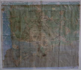
Map, Long Tan Original Battle Map
Original topographical map of Long Tan area showing operational marking in black pen. Areas 1-4 marked 5RAR section.This map is the original map from 1 ATF HQ on the day of the Battle of Long Tan, 18th August, 1966.battle of long tan, map -
 Montmorency–Eltham RSL Sub Branch
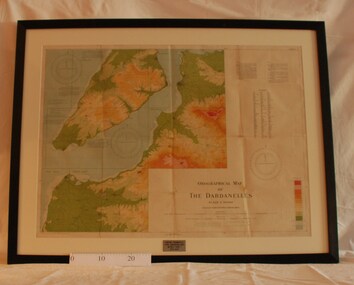
Map - Framed 1915 Map of Krithia, Gallipoli, 1915 Map of Krithia, Gallipolli, 1915
A framed topographical map of The Dardenelles produced from captured Turkish maps by the Egyptian Survey Department. The main feature is the Krithia battlefield area in 1915.Krithia Peninsula (The Dardenelles) World War One - 1915 Mapworld war one, 1915, egypt, map, dardenelles, krithia, survey department, turkey, battlefields -
 Warrnambool and District Historical Society Inc.
Document - Warrnambool City Council Preliminary Report Industrial Estate West Warrnambool, E Johnson, 9 March 1973
This preliminary report relates to 32½ acres of council owned land in West Warrnambool bounded on the North by McMeekin Road, on the East by Scott Street, on the South by Evans Street and on the West by the rear boundaries of properties facing Landmann and Granter Streets. In 2010, West Warrnambool was the largest of Warrnambool’s existing industrial areas, comprising approximately 109ha of industrial zoned land, the majority of which (101ha) is zoned IN1Z, with the remainder zoned INZ3. The area comprises a mixture of lot sizes supporting a diverse mix of industries. Larger parcels are occupied by the abattoirs, scrap metal industries, freight, the Council Depot and storage. Smaller lots are occupied by smaller manufacturers and wholesalers and service industries. [Ref: Warrnambool Industrial Land Use Review. Mesh Pty Ltd July 2010]This document is a preliminary report prepared by the Warrnambool City Council Engineer in March 1973 and provides an example of the planning process undertaken to develop one of Warrnambool's industrial areas. It contains details and costings of the proposed subdivision. Two foolscaps size pages of typewritten information. A detailed topographical map of the area with areas highlighted in blue, red, green, blue and purple pen.warrnambool city council, west warrnambool, industrial estate -
 Kiewa Valley Historical Society
Map - Cattlemen from Kiewa Valley
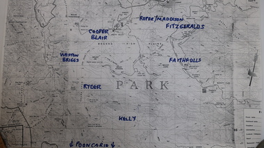
Cattle grazing on the Bogong High Plains occurred on most summers since the 1840s. The families were farmers from the Kiewa Valley. The 2003 fires interrupted this tradition which was discontinued altogether in 2005 for environmental reasons. This tradition is still controversial.History of Cattle grazing on the Bogong High Plains and farming in the Kiewa Valley and the families that lived there.Photocopied topographical map of part of the Alpine National Park showing 11 families areas for cattle grazing. Dated 1991/92 up to 2003 fires.91/92 Until fires in 2003 Families names have been added in blue texta. They are: 'Kelly, Faithful, Weston Briggs, Ryder, Cooper, Blair, Roper, Maddison, Fitzgeralds, Hicks.'cattlemen of the kiewa valley, cattle grazing on the bogong high plains -
 National Vietnam Veterans Museum (NVVM)
Poster - Poster, Information Board, Behind The Wire
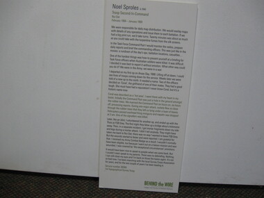
Storyboard of Noel Sproles, troop Second In Command Nui Dat February 1968 - January 1963. Service Number 36566, 1st Topographical Survey Troopstoryboard, behind the wire, nui dat, noel sproles, 1st topographical survey troop -
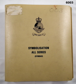 Bendigo Military Museum
Manual - Symbolisation All Series (Symbas), Specification for maps produced by the Royal Australian Survey Corps, C 1988
Symbas provides the specification (rules) for the collection and compilation of topographic data; the basic instructions for colour preparation and reproduction of topographical detail on maps produced by RASvyPlastic cover, book, beige, 7 chapters, metal clip bindingroyal australian survey corps, rasvy, fortuna, army survey regiment, army svy regt, asr, symbas, specification -
 Clunes Museum
Book, Fred Cahir, My Country All Gone The White Men Have Stolen It - The Invasion of the Wadawurrung Country 1800-1870, 2019
THIS BOOK REALLY BEGAN ON THE NULLABORE PLAIN IN 1983 WHEN I WAS CYCLING SOLO ACROSS AUSTRALIA FROM PERTH TO MELBOURNE...Soft Cover book , depicts a young Aboriginal women wrapped in a possum skin cloak standing in front of an early topographical map of Port Phillip. 348 pages.non-fictionTHIS BOOK REALLY BEGAN ON THE NULLABORE PLAIN IN 1983 WHEN I WAS CYCLING SOLO ACROSS AUSTRALIA FROM PERTH TO MELBOURNE...first nations history, wadawurrung country -
 National Vietnam Veterans Museum (NVVM)
Map, Intelligence Map
Vinyl coated topographical map of part of Vietnam featuring main roads, towns and city locations current or ruined. River locations etc. Names all in Vietnamese language.map, vietnam -
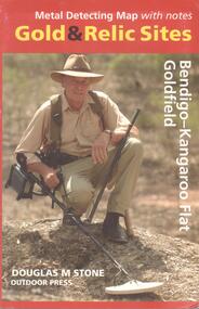 Bendigo Historical Society Inc.
Map - METAL DETECTING MAP WITH NOTES: GOLD AND RELIC SITES - BENDIGO KANGAROO FLAT GOLDFIELD
BHS CollectionMap of the Bendigo and Kangaroo Flat Goldfields with key to diggings, structures, locations of nuggets previously found and topographical features. Enclosed in a coloured cardboard cover with photograph of gold detector.Douglas M Stone, Outdoor Pressmap, bendigo, goldfields -
 Ballan Shire Historical Society
Map - Map. Moorarbool East and West, Country Lands in the Parishes of Moorarbool East and Moorarbool West. Counties of Bourke and Grant
This is a map of "Country Lands" around the Werribee River, north of Ballan in the Counties of Bourke and Grant.A relatively small map, paper on a material backing. Shows topographical features, roads and property divisions. Scale of forty chains to one inch. The map is dated March 31st, 1859.There is a small inscription under the chain scale that reads "No 58/364 John Phillips ? Survey 1st August 1858". The name Dugald McPherson is hand written on one of the blocks of land.moorarbool west, moorarbool east, dugald mcpherson, county of bourke, county of grant, werribee river, ballan -
University of Melbourne, Burnley Campus Archives
Map - Topographic Survey, Grampians, 1969
Australia 1:100,000 Topographic Survey Map of the Grampians, Victoria dated 1969. Sheet 7323 (Edition 1) Series R 652. Produced by the Royal Australian Survey Corps.grampians, royal australian survey corps, topographic survey -
Tarnagulla History Archive
Photocopies of historic maps - Tarnagulla region, varied
David Gordon Collection. Four photocopies in clear sleeve: (a) topographic with mines near Tarnagulla (b) Parish map ?- Tarnagulla & surrounds (c) Parish map ?- Tarnagulla & surrounds (d) Plan of Roads, Tarnagulla & Newbridge -
University of Melbourne, Burnley Campus Archives
Map - Topographic Survey, Ararat, 1970
Australia 1:100,000 Topographic Survey map of Ararat district, Victoria dated 1970. Sheet 7423 (Edition 1) Series R 652. Produced by the Royal Australian Survey Corps.royal australian survey corps, ararat area, stawell area -
 Bendigo Military Museum
Poster - Map Production flow chart poster using Automap 2, Army Survey Regiment, Bendigo, 1982
This poster designed to be folded into a brochure describes the second phase of the computer assisted cartographic system to be used by the Royal Australian Survey Corps in the establishment of a topographic data base, Future tactical applications and map products using the data base are displayed. A topographic map of Series R631 1:100,000 Helenvale, Queensland printed on the reverse side that was produced by the Automap system using information from the topographic data base. This is the fifth edition of the poster.A multi colour poster of map production using the Automap 2 system. Poster shows a schematic and pictorial flow chart diagram of the stages of the map production process using the Automap 2 system. The poster was intended to be folded into a small brochure. A 1:100,000 Army Survey Map Series R631, 7966 Helenvale, Queensland Edition 2 is printed on the reverse side of the poster. The map is an example of one of the initial maps produced on the Automap 2 System at the Army Survey Regiment, Bendigo.royal australian survey corps, rasvy, fortuna, army survey regiment, army svy regt, asr, automap 2 -
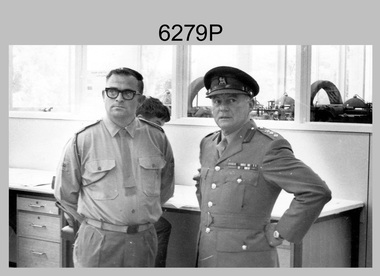 Bendigo Military Museum
Photograph - Visit to Army Headquarters Survey Regiment, Fortuna, Bendigo by D-SVY COL Frank Buckland OBE, c1971
This photo of WO2 Don Taylor and D-SVY COL Frank Buckland OBE was taken during a tour by D-SVY through Topographic Squadron at the Army Headquarters Survey Regiment, Fortuna, Bendigo circa 1971. Wild B8 Aviograph Stereoplotters are visible inside the windows in the background. BRIG Frank Buckland OBE served in the Australian Army from 01 June 1938 to 31st of October 1972. LTCOL Frank Buckland was the CO of the Army Headquarters Survey Regiment from 1962 to 1965. After promotion to COL Buckland was appointed as Director of the Royal Australian Survey Corps from March 1967 to August 1972. COL Buckland was promoted to Brigadier (retired) to the honorary position as Colonel Commandant from January 1973 to January 1976. WO2 Don Taylor served in the Australian Army from 24th October 1960 to 31st December 1987 and ended his service as a commissioned officer and reached the rank of Major. He was the OC of 4th Field Survey Squadron, Adelaide SA for several years.This photograph of the Royal Australian Survey Corps (D-SVY) COL Frank Buckland OBE was taken during a D-SVY tour through Topographic Squadron, at the Army Headquarters Survey Regiment, Fortuna, Bendigo circa 1971. The black and white photograph was printed on photographic paper and is part of the Army Survey Regiment’s Collection. The photograph was scanned at 300 dpi. .1) - Photo, colour, c1971, L to R: WO2 Don Taylor, Director of the Royal Australian Survey Corps COL Frank Buckland OBE. There are no annotations.royal australian survey corps, rasvy, army survey regiment, army svy regt, fortuna, asr -
 National Vietnam Veterans Museum (NVVM)
Document, Restricted Intelligence Centre
Yellowing paper Restricted 1: Army Intelligence Ctnre - Revolutionary Warfare - General. Six pages marked Index 2: Intelligence Centre - Topographical Interpretation Vegetation in S.E Asia - eight pagesdocument, restricted intelligence centre -
Creswick Campus Historical Collection - University of Melbourne
Map, 1937-1942
Linen backed topographical Maps - Victoria. 26 folding mapsMapsSchool of Botany, Univerity of Melbourne -
Creswick Campus Historical Collection - University of Melbourne
Map, 1937-1942
Linen backed topographical Maps - Victoria. 21 folding mapsMapsSchool of Botany, Univerity of Melbourne -
 Kiewa Valley Historical Society
Maps - Tawonga and Feathertop
Plan of Tawonga showing roads etc, rivers, use of land in 1968 and of Feathertop in 1969.Historical use of land in Tawonga and Feathertop.1. Topographical Map - Tawonga 803 Forests Commission of Victoria 1968. Cream paper with black print. Legend: Roads, tracks etc, rivers, Parishes and use of land. 2. Feathertop 813. 1969tawonga map 1968, tawonga parishes, feathertop map 1969 -
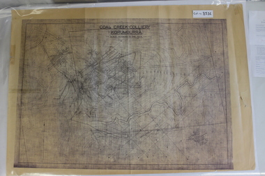 Coal Creek Community Park & Museum
Map of Mine and Details, Coal Creek Colliery Korumburra
8516.1 - Schematic/map of coal creek mine workings, also detailing number surface features such as topographic heights, roads, railways, boreholes, etc. No Legend. Most information seems to be printed, with topography drawn on. -
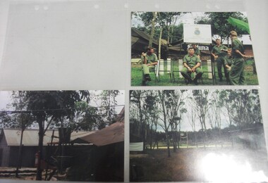 National Vietnam Veterans Museum (NVVM)
Photograph
Three Colour Photograph taken in Vietnam 1. Seven Khaki clad men in front of sign Royal Australian Survey Corps 1st Topographical Survey Troop 2+3. Scenes of building and treesphotograph, royal australian survey corps -
Glenelg Shire Council Cultural Collection
Book, M.M. CRAWFORD, Ourselves and the Pacific, c. 1943
Hardback green, blue print, history of nations bordering Pacific Ocean, black and white maps. Front endpaper, trade and population map, green and whte back endpaper, topographical map of the Pacific, green and whitehistory, pacific, geography -
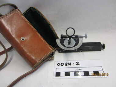 Wannon Water
Clinometre / Abney Level, E. R. Watts & Son, Clinometre
Abney Level / Clinometer is an accurate surveying tool used to measure degrees, percent of grade and topographic elevation. Used for surveying pipe lines.Instrument which consists of a fixed sighting tube, a movable spirit level connected to a pointing arm which turns and pivots. Adjustment knob/screw on top turns to rotate the compass indicator and bubble level. Arched scale graduated 0 to 90 degrees in both directions. Clinometer is housed in a brown leather case with a long leather strap for carrying around the neck.Watts London / No 70131 / Made in England -
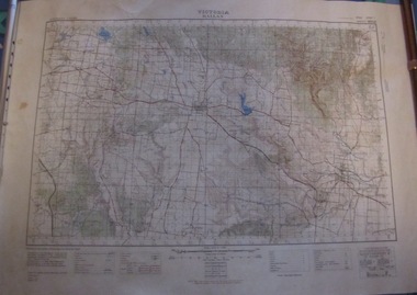 Ballarat Tramway Museum
Map, Australian Survey Corps, "Victoria Ballan", 1933
Topographic map of the Ballan area - includes Bacchus Marsh and Bungaree, No. 837, Zone 7, Army Map, dated 1933, 1:63360. Shows rail lines, roads, elevations, contours. Collected with relevance to the Museum's association with the area, at Bungareetrams, tramways, bungaree, map -
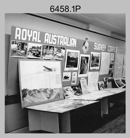 Bendigo Military Museum
Photograph - Royal Australian Survey Corps role and technical capabilities display, c1960s
This is a collection of four photographs taken in the 1960s of Royal Australian Survey Corps displays promoting its role and technical capability to acquire, process and disseminate topographic information to the Australian Defence Force. Map products formed a large part of this topographic Support. The photos may have been taken at a Careers Expo or a Department of Defence promotion. It is possible the photos were taken at separate events. This is a collection of four photographs taken in the 1960s of Royal Australian Survey Corps displays promoting its role in Defence and technical capabilities. The black and white photographs were printed on photographic paper and are part of the Army Survey Regiment’s Collection. The photographs were scanned at 300 dpi. .1) to .4) - Photo, black & white, 1960s. Royal Australian Survey Corps Display at unknown location.There are no annotations.royal australian survey corps, rasvy, army survey regiment, army svy regt, fortuna, asr -
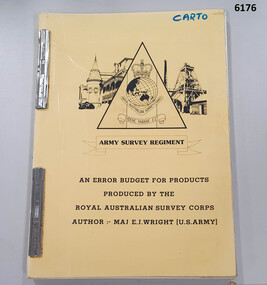 Bendigo Military Museum
Administrative record - An Error Budget for Products produced by the RASvy Corps, Major Edward J Wright US Army Corps of Engineers, 1988
This document is an analysis determining the positional accuracy (size of errors) within Topographic Mapping Products produced by the Royal Australian Survey Corps.A yellow carboard covered booklet, 2 x "ARNOS" fasteners, Army Survey Regiment Unit emblem designed by SSgt Denis MacCarthy.royal australian survey corps, rasvy, fortuna, army survey regiment, army svy regt, asr -
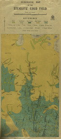 Federation University Historical Collection
Map, Geological Map of The Stieglitz Gold Field, 1940
At the bottom of the 2nd page, there is text that reads "Geologically and topographically surveyed in 1909 by W.H. Ferguson, Assistant Field Geologist. Published 1940."Rectangular geological map edged in masking tape showing Steiglitz, Victoria. Scale 48 chains to 4 inches.steiglitz, geology, geological map, north albion, moreep, mining, mine, caribald reef, durdidwarrah, gilbraltar hill, mount pleasant gully, township of steiglitz, w.h. ferguson, garibaldi reef, yankee gully, kinglock mine engine shaft, herbert werner frederick de nully, albion gully, virago reef, mulrooney's reef -
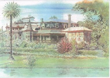 Bendigo Historical Society Inc.
Card - FORTUNA COLLECTION: CARD
Invitation card - colour sketched print, view of Fortuna Villa with palm tree on left hand side, flag pole in centre and partial view of lake. Wording inside the card reads ' On 1 October 2000 the Defence Topographic Agency will join with Australian Imagery Organisation and become part of the Defence Imagery and Geospatial Organisation. Defence Topographic Agency invites you to celebrate this special occasion by attending a presentation ceremony and BBQ. The cermony will be held at Fortuna on Thursday 26 October 2000 commencing at 12 noon. RSVP 19 October 2000, with Email address and phone number -
Federation University Historical Collection
Map, Creswick Gold Field Map, 1981
A fragment of the original 1880 map is also held in the collection. See 116Rectangular geological map with brown paper strip on top edge with 4 holes on top edge. Scale is 40 chains to one inch.Geologically and topographically surveyed by Ferdinand M Krause. Lithographed by R. Shepherd. Printed by J. Finnie. Mining Department, Melbourne. Preprinted with additional shaft and lead detail. F. D. Atkinson, Government Printer 1981creswick, krause, surveyor, smeaton, spring hill, tourello, ascot, dean, bullarook, gold fields, gold -
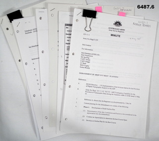 Bendigo Military Museum
Document - Disbandment of Army Survey Regiment Planning 1995, Army Survey Regiment, Bendigo, December 1995
.1 Disbandment of Army Survey Regiment (ASR) Planning19 May 1995. Reference A - DCGS Directive /95 Implementation of the In-house option for the provision of Digital Topographic Support to the ADF. Reference B - Army Svy Regt 623-11-02 262/95 ADF Contingency Capability for the Provision of Topographic Data during the transition ASR to ATSE dated 12 May 1995. Reference A directs the ASR to be disbanded by 1 Dec 1996. Planning for the Disbandment is to consist of the following: Phase 1 - Development of Draft Outline Plan (1) Determine the Aim, Limitations and factors to be considered in the appreciation into the disbandment, (2) Conduct an appreciation to determine the best course of action, (3) Develop an Outline Plan for the Best Course of Action. (4) Brief DSVY-A and staff on the proposed Outline Plan. Phase 2 - Review of the Outline Plan by DSVY-A and issue further guidance. Phase 3 - Develop the Detailed plan including project management strategy. The disbandment is to achieve the smooth transition of operational responsibility to ATSE. The responsibility and resources to maintain the Minimum Operational Capability outlined in Reference B is to be formally passed to ATSE prior to disbandment. Proposed timings: Phase 1 completed by 1 Jun 95, Phase 2 completed by 15 Jun 95, Phase 3 complete d by 30 Jun 95, Disbandment completed by no later than 1 Dec 96 (Executive Order). All postings, administration and stores and equipment returns are to be completed by this date. .2 Disbandment of Army Survey Regiment Planning Report 26 May 1995 - Develop possible courses of action for the disbandment of ASR with reference to Technical, Historical and Union Issues by 6 Jun 95. .3 Disbandment of Army Survey Regiment Disbandment Team 26 May 1995 - Allocation of Team Members and responsibilities. .4 Disbandment of Army Survey Regiment May 1995 - Minimum Contingency Technical Equipment List for transition to ATSE. .5 Disbandment of Army Survey Regiment Plan 23 Aug 1995 - During the transition period (1 Jul 95 - 1 Dec 1996) leading to the full implementation of the Preferred In House Option (PIHO) Army Svy Regt and ATSE will at all times operate concurrently whilst Army Svy Regt scales down production and progressively transfers all technical functions to ATSE. Army Svy Regt will continue programmed production activities at best endeavor until declared operationally ineffective. During the transition to ATSE a contingency mapping capability is to be maintained. .6 Directorate of Survey - Army Commercial Support Program Digital Topographic Support to the ADF In-House Option Directive Dec 95. This directive defines the CSP contract management arrangements between the contract Administrator (DSVY-A) and the Contractor (ATSE) for the implementation and operation of the IHO for digital Topographic support to the ADF. .1 Disbandment of Army Survey Regiment Planning19 May 1995 - A4 paper clipped document, 4 x hole punched, 21 pages, diagrams and typed and hand written. .2 Disbandment of Army Survey Regiment Planning Report 26 May 1995 - A4 paper stapled document, 4 x hole punched, 9 pages, diagrams and typed and hand written. .3 Disbandment of Army Survey Regiment Disbandment Team 26 May 1995 - A4 paper stapled document, 4 x hole punched, 2 pages, typed. .4 Disbandment of Army Survey Regiment May 1995 - Minimum Contingency Technical Equipment for transition. A4 paper stapled document, 4 x hole punched, 2 pages, typed. .5 Disbandment of Army Survey Regiment Plan 23 Aug 1995 - A4 paper stapled document, 4 x hole punched, 10 pages, diagrams and typed. .6 Directorate of Survey - Army Commercial Support Program Digital Topographic Support to the ADF In-House Option Directive Dec 95. A4 paper clipped document, 4 x hole punched, 16 pages, diagrams and typed, hand written notes. royal australian survey corps, rasvy, fortuna, army survey regiment, army svy regt, atse, asr