Showing 270 items
matching tourist maps
-
 Kiewa Valley Historical Society
Folder - Bogong High Plains and Falls Creek, 1960's and 1970's
... Tourist Map & brochures 7. Bogong High Plains Tour 1973... and Mt Beauty Tourist Map & brochures 7. Bogong High Plains Tour ...Tourism on the Bogong High Plains developed after/during the State Electricity Commission of Victoria construction of the Kiewa Hydro Electric Scheme.With the completion of the power stations on the Bogong High plains, tourism has created a new focus and different infrastructure/lifestyle for the community.A blue folder with a collection of papers & booklets on: 1. Discovery of Bogong High Plains 1962 2. SECV Discovery of Bogong High Plains 1968 3. SECV Kiewa Hydro Electric Scheme 1911 - 1961 4. Newspaper cutting - Mt Beauty 1974 5. McKay Creek Power Station and Clover Power Station 6. Falls Creek and Mt Beauty Tourist Map & brochures 7. Bogong High Plains Tour 1973bogong high plains; falls creek; tourism; -
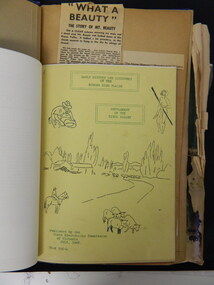
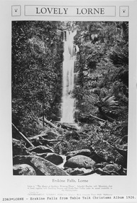 Lorne Historical Society
Pamphlet - Tourist Brochure, Lovely Lorne
... A folded paper tourist brochure about Lorne The front cover... sketch tourist map of the roads, tracks and beauty spots. Inside ...The Victorian Railways promoted tourist destinations around Victoria. A folded paper tourist brochure about Lorne The front cover is a coloured painting of Lorne from above the Erskine River towards the main beach. , on the back is a black and white sketch tourist map of the roads, tracks and beauty spots. Inside the first fold are 6 black and white photographs, Cumberland River, Mt St George, Phantom Falls, Cumberland Cliffs, Teddy’s Lookout, leafy walk towards the pier. Inside contains written descriptions of the highlights of Lorne and six black and white photographs, four general views of Lorne, Lover’s Walk, Erskine Falls . souvenirs, victorian railways, publicity -
 Glenelg Shire Council Cultural Collection
Pamphlet, The Holiday Spectacular, c. 1970
... attractions. Multi-fold pamphlet, coloured photos, maps, tourist..., coloured photos, maps, tourist information. The Holiday Spectacular ...Pamphlet. South west Victoria Australia. The Holiday Spectacular produced by Victorian Government to promote tourist attractions. Multi-fold pamphlet, coloured photos, maps, tourist information. -
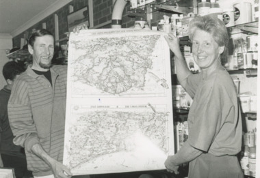 Lakes Entrance Historical Society
Photograph - Lakes Map Supplies, Lakes Post Newspaper, 1/12/1995 12:00:00 AM
... maps of Gippsland ready for the tourist season. Lakes Maps... holding illustrated maps of Gippsland ready for the tourist season ...Black and white photograph of Chris Turnbull proprietor of Lakes Map Supplies with artist David Clarke holding illustrated maps of Gippsland ready for the tourist season. Lakes Maps located on the Esplanade Lakes Entrance Victoriabusinesses, commerce -
Glenelg Shire Council Cultural Collection
Pamphlet - Pamphlet - What's on in Portland Tourist Guide, Mar-72
... Two copies of 'What's on in Portland', tourist guide... on in Portland', tourist guide, including map of portland with historic ...Two copies of 'What's on in Portland', tourist guide, including map of portland with historic buildings marked. Also advertising 'Back to Portland March 3 - 13 1972' a. pink paper, black print. b. yellow paper, black print. -
Glenelg Shire Council Cultural Collection
Souvenir - Souvenir - Map and Sticker, South West Victoria, n.d
... a. Tourist Guide to the S.W. region - fold out map... to the S.W. region - fold out map, with tourist destinations marked ...a. Tourist Guide to the S.W. region - fold out map, with tourist destinations marked; description on reverse. b. Bumper sticker, round, red, with white print ' 'Victoria, all it needs is you' - Victorian Ministry of Tourism logo. -
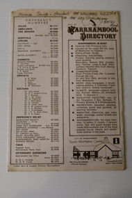 Warrnambool and District Historical Society Inc.
Pamphlet - Warrnambool Directories, Warrnambool City Council (Warrnambool Tourist Information Centre), Warrnambool Directory. Welcome to Warrnambool, Warrnambool and District Directory, 1970s and 80s
... ) for the benefit of both local residents and tourists. They contain maps...) for the benefit of both local residents and tourists. They contain maps ...Warrnambool Directories.1 and .2 One sheet of paper folded twice to provide six pages. The pages contain a map and printed material. .3 One sheet pf paper folded to provide sixteen pages. The pages contain two maps and printed material. The front page has a stamp indicating the original owner. non-fictionWarrnambool Directorieswarrnambool tourism, shipwreck coast tourism -
 Ballarat Tramway Museum
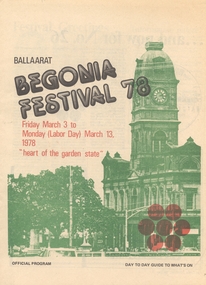
Memorabilia - Event Materials, The Courier Ballarat, "Ballarat Begonia Festival - Day to Day Program ", 5/06/2007 12:00:00 AM
... advertisements of local sponsors, places to see (eg Ballarat Tourist... "A Tourist Guide Map of Ballarat". "Ballarat Begonia Festival - Day ...Set of three, "Ballaarat Begonia Festival" programs for .1 - 3/3/1978 to 13/3/1978 .2 - 29/2/1980 to 10/3/1980 .3 - 27/2/1981 to 9/3/1981 Note the spelling of the word "Ballarat" is with two a's in the official part of the programme. All programmes printed on newsprint, with some colour work on the cover, giving details of the events on a day by day basis, many advertisements of local sponsors, places to see (eg Ballarat Tourist Tramway), 1980 and 1981 have advertisements for the BTPS. The 1981 programme contains a printed sheet titled "A Tourist Guide Map of Ballarat". trams, tramways, btps, begonia festival, festival program -
 Eltham District Historical Society Inc
Document - Folder, Jarrold Cottage (White Cloud), 701 Main Road, Eltham, c.2002-c.2014
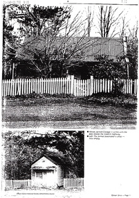
... Cottage (7), extract from tourist drive map publication (unknown... Cottage (7), extract from tourist drive map publication (unknown ...Information pertaining to the former Jarrold Cottage built in the early 1850s which has been in the Skipper family since 1944 Contents: 1 Journal Article: Jarrold Cottage; This quaint house survived fire and flood, Eltham Shire, newsletter c.2002, p10-11 2. Newspaper article: Cottage of 1800s, 100 Years of News Special Edition, (Leader Newspapers), August 27, 1997, p36 3. Jarrold Cottage (7), extract from tourist drive map publication (unknown) 4. Journal Article: Eltham . . . then and now, written by Judy Lewis, Eltham Town Community News, pp10-11, date unknown with hand written comments/corrections by Diana Bassett-Smith. Features Jarrold Cottage, Southernwood and Walter Withers and the former CBA Bank building. 5. Artice: Jarrold Cottage or White Cloud Cottage, compiled by Harry Gilham (2 pages)Folder of information on Jarrold Cottage consisting of 5 A4 photocopies and one A3 (colour) two page journalbootmakers cottage, cba bank, eltham, jarrold cottage, main road, southernwood, walter withers, white cloud cottage -
 Melbourne Tram Museum
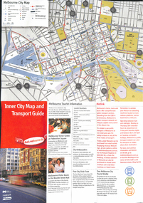
Map, City of Melbourne, "Inner City Transport Map", c1990
... Map", providing information for Tourist Information centres.... Melbourne City Tourist Shuttle, and two maps, one provided by Melway ...Map - 6 fold DL - full colour titled "Inner City Transport Map", providing information for Tourist Information centres, Metlink. Melbourne City Tourist Shuttle, and two maps, one provided by Melway giving a list of attractions. Published by City of Melbourne, Melway and Metlink with each of their logos.trams, tramways, map, public transport, city of melbourne, metlink -
 Melbourne Tram Museum
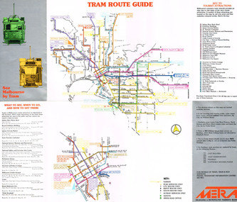
Pamphlet, Melbourne & Metropolitan Tramways Board (MMTB), "See Melbourne by Tram", early 1980's
... by Tram" providing a detailed tram map of Melbourne, key tourist... of Melbourne, key tourist locations marked on map. Notes ...Fold out pamphlet - 10 sections, titled ""See Melbourne by Tram" providing a detailed tram map of Melbourne, key tourist locations marked on map. Notes that Travelcard Zone 1 can be purchased for all locations. Published by the MMTB early 1980's. Trading name used on pamphlet is "METRA". On inside has sketches and advertisements for some tourist locations and restaurants. Notes which routes were replaced by buses on Sundays. Second copy added 13/1/2017 from Donation of John Prideaux.trams, tramways, map, mmtb, metra -
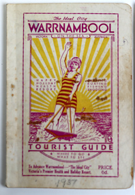 Warrnambool and District Historical Society Inc.
Booklet - Warrnambool Tourist Guide, Warrnambool Progress Association, Warrnambool On The Sea Tourist Guide, The Ideal City, Where to Go and What to See, 1936
... information for tourists, including local maps, black and white... information for tourists, including local maps, black and white ...Warrnambool Tourist Guide 1936This is a booklet with a buff-coloured cover featuring an illustration of a woman water skiing. The back cover has blue printing. The pages contain a fold-out map, advertisements, printed text and black and white photographs. The pages have been stapled and then glued.non-fictionWarrnambool Tourist Guide 1936tourism in warrnambool, warrnambool progress association -
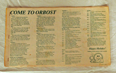 Orbost & District Historical Society
brochure, Come To Orbost, c 1980's
This brochure was produced as a tourist guide to Orbost.This item is a useful research tool.A magazine/brochure for use as tourist information. It contains the history, maps and touring routes of the Orbost district.tourism-orbost -
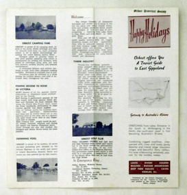 Orbost & District Historical Society
pamphlet, Snowy River Mail, Happy Holidays
This pamphlet was probably produced for use in the Slab Hut (Orbost Visitor Information Centre)These pamphlets are useful reference tools and reflect the tourism history of the local area.Two single page tourist brochures, printed on both sides and folded in the middle. They are white with pink and blue print. and have a map of East Gippsland and descriptions of places to visit.tourism-orbost -
 Orbost & District Historical Society
map/brochure, Discovering Marlo & The Snowy River Estuary, December 1988
... /map was used as tourist information in Orbost..../map was used as tourist information in Orbost. This item ...In 1983 the Department of Conservation, Forests and Lands replaced the Department of Crown Lands and Survey, the Department of State Forests and the Ministry for Conservation. This brochure/map was used as tourist information in Orbost.This item is a useful research tool.A folded map/brochure titled "DISCOVERING MARLO & THE SNOWY RIVER ESTUARY". On the front is a photograph of Marlo and the title in yellow print. There is a locality map for access to Corringle beach and the brochure Includes a key to fishing sites and various tourist locations. On the back of the brochure are notes on fishing, wildlife and a boating guide, map brochure snowy-river marlo -
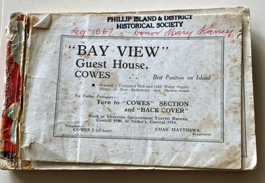
![Booklet, Souvenir of Phillip Island [Cowes, Rhyll, Newhaven etc] and San Remo, Late 1920s. Post 1926](/media/collectors/4f729f5b97f83e0308601629/items/6462d05d551955aaca8bbecf/item-media/6462d125551955aaca8c0867/item-fit-380x285.jpg) Phillip Island and District Historical Society Inc.
Phillip Island and District Historical Society Inc.Booklet, Souvenir of Phillip Island [Cowes, Rhyll, Newhaven etc] and San Remo, Late 1920s. Post 1926
Broadbent's Official Road Guides Company took over George R. Broadbent's business in 1935. In 1963, it changed its name to Broadbent's Road Maps Pty. Ltd. Broadbent's company produced many maps, road and tourism guides of Australia.HistoricalSmall, beige coloured booklet with blue print and round photo of S.S.Alvina at Cowes jetty on cover. Advertisement for Westernport Steamer Service on rear page. Contains descriptions of main towns and places of interest. Also advertisements for guesthouses, businesses and tourist guides.Broadbent's Holiday Guide to Phillip Island and San Remo. [alternative title]tourist brochure, souvenir, broadbent's guides, phillip island accommodation, ferries, maps, guesthouses, hotels, shops -
 Phillip Island and District Historical Society Inc.
Booklet, Victorian Country Hotel & Guest House Guide 1939-40 "Where to go" in Victoria, 1939
Details of tourist accommodation options on the IslandHistoricalSmall, red bound booklet with maps, tables, descriptions and photos advertising tourist accommodation in country Victoria.Victorian Country Hotel & Guest House Guide 1939-40 "Where to go" in Victoriatourist brochure, bayview guest house, guesthouses, carisbrooke guesthouse cowes phillip island, cowes progress association, cora lynne, the isle of wight hotel cowes phillip island, phillip island hotel, douglas house, hollydene guest house, osborne park guesthouse, marldon house, bonnie doon, yackatoon, elsford, widgee -
 Phillip Island and District Historical Society Inc.
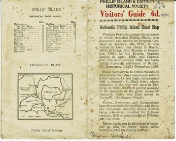
Booklet, Authentic Phillip Island Road Map, Pre 1960
... Island Printers pre 1960 Historical Tourist brochure Road map ...Tourist brochure printed by the Phillip Island Printers pre 1960HistoricalSmall cream coloured brochure with details of accommodation, transport and animals. Inside is a map of the Island with numbered points of interest. There is also a plan of Cowes and drawings of animals.Visitors' Guide 6d Authentic Phillip Island Road Maptourist brochure, road map -
 Phillip Island and District Historical Society Inc.
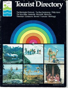
Booklet, Tourist Directory 1981 and Guide to Phillip Island & surrounds 1995
... Accomodation restaurants Map of Phillip Island Tourist Directory ...HistoricalLarge black booklet with brightly coloured cover with tourist photos. Inside is black type with descriptions, maps, advertisements and photos. Guide is smaller with white and red writing and maps. Inside it has red writing on history, climate and information on Phillip Island and small advertisements of attractions.Tourist Directory, Published by Westernport Healesville Regional Tourist Authority Victoria. Printed by Standard Newspapers, Cheltenham. Guide to Phillip Island & surrounds.Phillip Island Information Centre RMB 1305 Newhaven.tourism, tourist brochure, accomodation, restaurants, map of phillip island -
 Phillip Island and District Historical Society Inc.
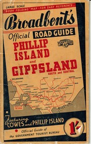
Booklet, Broadbent's Official Roadguide Phillip Island and Gippsland 45, c. 1945
Broadbent's was the official guide of the Government Tourist Bureau. Mr Roy Bain owned a secondhand shop on corner of Thompson Ave and Chapel Street, Cowes, currently a Japanese restaurant.HistoricalSmall orange, black and red booklet with black type containing maps and information of accommodation, businesses and tourist venues.Broadbent's Official Road Guide Phillip Island and Gippsland South and Central. Broadbent's Year of Issue 45.guesthouses, broadbent's guides, hislop newsagency, underdown strawberry farm, osterlund fishing trips, parry's butcher, athenia cafe, roy bain, broadway bakery, cowes camping ground, cowes main garage, beach park camp -
 Flagstaff Hill Maritime Museum and Village
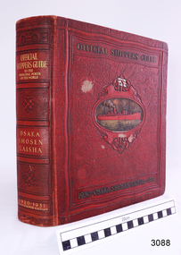
Book - Reference, M. Franklin Kline, Official Shippers Guide, 1930
This book has information about shipping companies and the world's ports. It was a handy guide for travellers of the time and included how and where to board ships going to various countries in 1930 & 1931. In effect, it was a reference work like a timetable for shippers and travellers alike.The book has maps depicting N.Y.K. shipping lines all over the world, indexes (including advertisers), and is thumb-indexed. This book is an official guide that supplies vast information for ships and shipping lines but also for tourists of the time. These types of reference works are keenly collected today.Official Shippers Guide reference book to the Principal Ports of the World, OSAKA SHOSEN KAISHA, 1930 – 1931, Seventeenth Edition, edited, compiled and designed by M. Franklin Kline. Large, hard covered, bound book with margin thumb tabs. Covers are dark red with gold lettering and embossed pattern. Centre of front cover has an oval image of a red steam ship on a gold sea. Above the ship is a white flag with a red emblem.flagstaff hill, warrnambool, flagstaff hill maritime museum, maritime museum, shipwreck coast, flagstaff hill maritime village, great ocean road, traveller's guide, shippers guide, osaka shosen kaishaguide, guide to world ports, m. franklin kline -
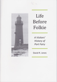 Warrnambool and District Historical Society Inc.
Booklet - Booklet about Port Fairy, Life before Folkie, 2013
This booklet aims to give a brief outline of Port Fairy’s history for the benefit of visitors. Port Fairy was an early sealing and whaling town with white settlement established by 1836. As the port and shipping declined so did the town until its reinvigoration in the mid 20th century as a tourist town and the home of the annual Port Fairy Folk FestivalThe book is of use as a quick reference to Port Fairy history.This is a booklet of 48 pages. It contains printed material, black and white photographs and a map. The front cover has a black and white image of the Port Fairy lighthouse. Front Cover: ‘Life Before Folkie, A Visitors’ History of Port Fairy, David R. Jones’port fairy, david r. jones -
 Warrnambool and District Historical Society Inc.
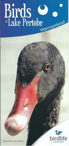
Document, Pamphlets lake Pertobe, 2014
Lake Pertobe in Warrnambool is a former swamp area which was transformed into a recreational area and children’s playground in the 1970s. The reserve is a popular spot for bird watching with over 80 species found in the vicinity. The brochure on Lake Pertobe’s birds had been produced by BirdLife Warrnambool, part of BirdLife Australia, an independent, not-for profit organisation aiming to protect our birdlife and disseminate information on Australian birds. This is an important little brochure as it contains information for locals and tourists about the birdlife in Lake Pertobe, one of the best-known and best-loved spots in WarrnamboolThis is an A3 sheet of paper printed on both sides and folded three times to form a brochure. It contains colour photographs of birds, two maps and information about BirdLife Warrnambool and BirdLife Australia and the logo of Birdlife Warrnambool.Front Cover: ‘Birds of Lake Pertobe, Warrnambool, BirdLife Warrnambool, Birds are in our nature’ lake pertobe, birdlife warrnambool, warrnambool -
 Warrnambool and District Historical Society Inc.
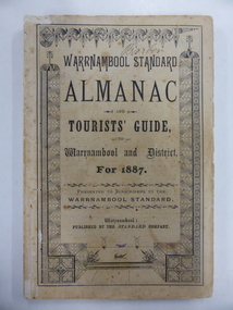
Book, Warrnambool Standard Almanac 1887, 1887
This booklet was given to subscribers to the Warrnambool Standard newspaper as an almanac for the year 1887. These Standard almanacs were produced from 1875 to 1930. They contain much local information on Warrnambool and district about the businesses, government officials, schools, societies and organizations, harbour management, churches, banks etc. The Warrnambool Standard newspaper was established in 1872 and continues to this day. This booklet is of high significance as it contains much valuable information on Warrnambool and district for the year 1887. It is a very important research tool for those studying and writing the history of Warrnambool and district. This copy has the name ‘Barber’ on the front cover and probably refers to George Barber, the son of George Barber, a well-known solicitor who opened a legal practice in Warrnambool in 1855. He died in 1879 and it appears that a member or members of his family went to live in the Maryborough district. This copy came into the collection of the Warrnambool and District Historical Society via the Midlands Historical Society. This is a soft cover booklet of 73 pages, plus several pages of advertisements. The section on the tourist’s guide to Warrnambool is printed in pink. There is a fold-out page with a map of the railway routes in Victoria. The cover is buff-coloured with black lettering and is slightly frayed. There is some scribble on the first page and the back cover. There are many black and white illustrations and several sketches of Warrnambool and district printed in pink. The name ‘Barber’ is handwritten in black ink on the front cover. ‘Barber’ ‘Miss Duff c/o Mrs Hyslop Farquar Lodge Lysle Street Ladysmith South Africa’warrnambool standard newspaper, history of warrnambool, standard almanac1887 -
 Kiewa Valley Historical Society
Photograph - Bogong Village (7 copies), Approx 1940
In 1940 Field Headquarters for the Kiewa Scheme were established at Bogong with office, workshop facilities and accommodation for workmen, staff and some families constructed. (There had been a 'tent camp' on this site in 1939 but was destroyed by bushfires) Construction of accommodation continued until 1947. A total of 40 houses plus a hostel for single staff, post office, police station, medical centre and primary school all with water and sewerage and electricity supply. The staff hostel was known as Kiewa House and is now occupied by the Education Department. Lake Guy was named after Mr. L.T. Guy who was the Resident Engineer in charge of construction work and associated activities on the Kiewa area. He held this position from 1939 to November 1946 when he was transferred to Head Office. The Bogong Township was developed firstly as an accommodation centre (base camp) for construction workers employed under the Kiewa Hydroelectric Scheme. Due to the influx of European workers into the Township the beautification of the immediate surrounds (gardens etc.) had a distinct European flavour. This environment has been very beneficial for tourism in later years. At the completion of the scheme, in the 1960's, the village was opened to public/tourism use. Strict environmental control has not allowed for any extensive redevelopment in tourist accommodation and basically restricted it to the accommodation initially built for the construction workers. Activities such a bike riding, snow skiing, restricted horse riding and bush walking on the Alpine plains and mountains are now a viable part of the Kiewa Valley Tourist Industry. The lake is one of the many water storage reservoirs used to supply the power stations their main power to run the huge turbines generating the final product, electricity. Evidence can be seen of the 1939 bushfires.Set of 7 identical black and white photographs of Bogong Village after 1939 bush firesHandwritten on the back of one photo - Bogong Village approx. 1940, after 1939 bush fires. Staff residences to left. Kiewa House, General offices and test lab to the right. Hand drawn map on the back of one photo.bogong village, secv -
 Kiewa Valley Historical Society
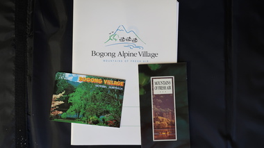
Papers - Bogong Village & the 'Commissioner's' Lodge & Progress Association Members, c 1997/1998
Bogong Village was built by the SECV in 1940 for the workers of the Kiewa Hydro Electric Scheme. In 1971, 30 houses were furnished for use as holiday homes for SEC personnel throughout the State. From 1989 to 1993 the houses were restored & renovated.During the 1990s the buildings in the village had been leased to private owners. Many of them rented their houses for tourists. The Commissioner's lodge was on the other side of the Mt Beauty - Falls Creek road, above Bogong Village. Wally Baldwin ran it in the 1960's.It was destroyed by the 2003 bushfires.These papers present a history of 'the Commissioner's lodge' and Bogong Village in the 1990's. The Progress Association was an active community group in 1963/64.Papers advertising Bogong Village & the Lodge for accommodation with rates 1997/1998. Describes the alternatives, maps and cafe hours, Also, 'Jan's Recollections' and on the back of these pages a hand written list of members of the the Progress Association 1963-64 as 'per Mr A. McCullough's spiel'. In original folder and includes a pamphlet & postcard.bogong village, secv lodge, lake guy, state electricity commission of victoria., kiewa hydro electric scheme, tourism, accommodation -
 Kiewa Valley Historical Society
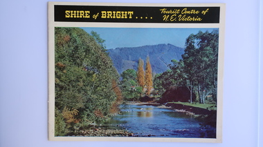
Brochure - Shire of Bright, Shire of Bright Tourist Centre of N.E. Victoria, Pre 1966
Bright and the surrounding towns were developing a large tourism industry which the Shire of Bright continues to promote, encouraging tourists to visit throughout the year. This high quality brochure has magnificent photos with a map showing the area and the distance (in miles) from the centre - the township of Bright.This brochure is promoting the Shire of Bright encouraging tourism in the area. This is important for the Shire as tourism is the main industry for the Shire. It is interesting to see how tourism has changed (or not) in the area.14 pages on glossy paper including colored and black and white photos. The front cover has the title at the top with yellow print on black background. Below the title is a large colored photo of a river, autumn trees and mountain. The back cover is a large colored photo of a man amongst the snow gums in the snow. The towns covered are Bright, Wandiligong, Eurobin, Mt Buffalo, McKay Creek Power Station, The Kiewa Hydro Electric Scheme, Mt Beauty, Kiewa, Bogong including tourist destinations in these areas and their surrounds.tourism; mt beauty; the kiewa valley; bright shire -
 Kiewa Valley Historical Society
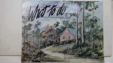
Brochure - Tourism, What to do - Souvenir Holiday Guide to North-Eastern Victoria
The Kiewa Valley has promoted itself as a tourist hot spot since the Kiewa Hydro Electric Scheme concluded. Mt Beauty began as a construction town and was to be sold off but tourism became promising so the SECV handed the town over to the Bright Shire, houses were sold and businesses commenced. From the early 1960s the town promoted itself and Falls Creek as a tourist destination. The Kiewa Valley Accommodation group combined with the local advertisers to publish this brochure.This brochure promotes tourism all year round promoting the local businesses enabling them to succeed. As tourism is the main industry in Mt Beauty and Falls Creek since the Kiewa Hydro Electric Scheme finished, this advertising is important. It is interesting to note the businesses - their type, their location and the comparison with those in the area now.19 black and white pages including maps and advertisements. Cover is a 'washed' color of a hut in the bush. The title is in black across the top and at the bottom right hand corner. The front cover is in 'landscape' format but the rest of the book is 'portrait'.mt beauty; falls creek; kiewa valley; tourism; north east victoria -
 Kiewa Valley Historical Society
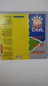
Brochure - Falls Creek Tourism, Falls Creek Never Out of Season
Falls Creek is a Ski Resort in the north east of Victoria. This brochure has been produced to encourage tourists to visit throughout the year.Tourism to the Kiewa Valley is an important industry for the area. Falls Creek is a ski resort with accommodation during winter for skiers, snow boarders and other snow sports. It involves entertainment, restaurants and associated workers. This brochure is produced to promote the resort throughout the year to increase the occupancy of these lodges. The tourist industry has increased steadily with fishing, cycling and bush walking increasing numbers in the area.Glossy square brochure folded in in half and half again. Front page is yellow on the left with black print on the far left. The right side has the title with blue, green and grey background with yellow, orange and white as part of the title. The back is a man standing in front of a sunset with print in a column towards the right side. Inside includes a map with advertisements for accommodation surrounding it.falls creek ski resort; alpine region in victoria; mountain lodges; -
 Kiewa Valley Historical Society
Maps, Unknown
... sides have advertising and information for tourists./ 4/-. Maps ...There are 2 maps: 1. Broadbent's Makers of Maps since 1896, No. 323 Across the Alps/Official Copyright Map./ The cover is blue, green and orange with advertising for Ólympic' and 'Bosch' and there is further advertising on the fold out covers/ 2/-. 2. Robinson's Kiewa Hydro-Electric Scheme & Hotham Heights Map No. 613, with Insets of: Bright, Mt Beauty, Falls Creek Ski Village, Hotham Heights Ski Village/ the cover is blue, green and orange with image of skier, hydro tower and locality map./Other fold out sides have advertising and information for tourists./ 4/-.maps, tourism, kiewa hydro electric scheme, victorian alps, skiing