Showing 183 items matching "vegetable gardens"
-
 Tatura Irrigation & Wartime Camps Museum
Photograph - copy, 1989 copy
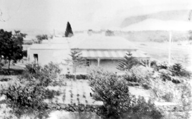
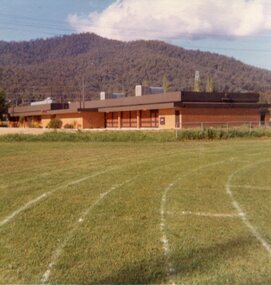
... . The view is from the vegetable garden and tennis court, looking... at Rushworth. The view is from the vegetable garden and tennis court ...Photograph is a view of Internment Camp 3 at Rushworth. The view is from the vegetable garden and tennis court, looking towards the huts. Camp 3 held Italian and German family groups. Black and white photograph. White posts in foreground leading to a gate entrance. Several army hut buildings behind fence. To the left of posts is a person sitting on a log.internment camp 3, rushworth victoria -
 Surrey Hills Historical Society Collection
Photograph, 'Glenisla', 18 Chestnut Street, Surrey Hills, c 1920, 1920
... may be a vegetable garden. There appears to be significant... gardens norman carter robert moore miss isabella bateson mrs ...Date is approximate. In 1920 this became the home of Mr and Mrs Robert Moore, whose daughter Mabel Annie married Norman Brodley Carter of Mont Albert. The house was named after 'Glenisla', a western District grazing property located between Hamilton and Horsham on the Henty Highway and on the edge of the Grampians National Park. This was established as a super-fine wool stud in 1860 and was passed down the family until it was sold in 1922. The family transferred from this property to Melbourne. Robert is listed as a grazier in the 1924 electoral roll at Chestnut Street. With him are Victor Cecil listed as a carpenter; Isabella, Mabel Annie and Edgar Gilbert listed as an orchardist. In 2003 the house was extant minus the verandas. This photo may have been taken from the rear of the property. Ref: History of original property - Age newspaper article: 'The Best - Glenisla: historic Grampians property', 7 January 1994. Moore family details: Robert Moore born 1857 on Isle of Man; died Surrey Hills 1940 Isabella Bateson born 1869; died Surrey Hills 1938 Married in 1894 in Miram, 10 km north-east of Kaniva in the northern Wimmera. All the children were born in Kaniva. Children: Lena Florence (1895-1980) Victor Cecil (1896-1984) - a builder Edgar Gilbert (1897-1976); died Surrey Hills; married Myrtle Emary, daughter of Henry John Emary of Surrey Hills Ernest Alan (1900-1900) Mabel Annie (1901-1957); died Surrey Hills married Norman Brodley Carter (1899-1984) Clarence Arthur (1904-2004). Norman Carter took many photos in the Surrey Hills and Mont Albert are from the 1920s; many is connection with Church of England events and activities. Robert and Isabella Moore are buried in Box Hill Cemetery. Black and white photo of a Victorian home with a veranda with a corrugated iron roof and lacework on 2 sides. It appears to have a later extension at the rear. It is surrounded by mature gardens with ornamental trees (cypresses) and an area with plants in rows, which may be a vegetable garden. There appears to be significant areas of open space around the house.glenisla, homes, victorian style, gardens, norman carter, robert moore, miss isabella bateson, mrs isabella moore, victor cecil moore, edgar gilbert moore, miss mabel annie moore, box hill cemetery -
 Lakes Entrance Historical Society
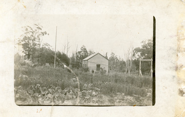
Postcard - Kalimna West School, 1900c
... on right, flag pole on left, vegetable garden in foreground, two... on left, vegetable garden in foreground, two people, lady and boy ...Building used as community hall and school until Education Dept built school nearby.Black and white postcard showing early Kalimna West Primary School, square water tank on side of building, home made swing on right, flag pole on left, vegetable garden in foreground, two people, lady and boy, dressed in 1900s style clothes. Uncleared bush in backgound. Kalimna West Victoriaschools, halls -
 Clunes Museum
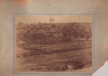
Photograph, PURCELL, ROGER, 1994
... AND VEGETABLE GARDEN CIRCA 1886 .3 SEPIA COPY ON PHOTO PAPER .4-.6 BLACK... SHOWING GARDENERS AND FENCE IN HARRIS FAMILY FRUIT AND VEGETABLE ...ORIGINAL PHOTOGRAPH OWNED BY MR. WILLIAM HARRIS OF SUTHERLAND ST. CLUNES.1 SEPIA ORIGINAL PHOTOGRAPH MOUNTED ON BOARD (CORNER TORN OFF) .2 SEPIA COPY ON CARD - SCENE OF SEBASTOPOL GARDENS CLUNES, VIEW SHOWING GARDENERS AND FENCE IN HARRIS FAMILY FRUIT AND VEGETABLE GARDEN CIRCA 1886 .3 SEPIA COPY ON PHOTO PAPER .4-.6 BLACK AND WHITE COPIES .2 "SEBASTOPOL GARDENS" CLUNES 1886 WINNER OF PICKLES AND JAMS COMPETITION IN CALCUTTA IN INDIA 1886 (IN PEN)local history, photography, sebastopol gardens, market garden -
 Ballarat and Queen's Anglican Grammar School
Photograph - Chapel, 1965
... Old Chapel, school garden and vegetables...Old Chapel, school garden and vegetables Photograph Chapel ... -
 Bendigo Historical Society Inc.
Newspaper - JENNY FOLEY COLLECTION: HISTORY
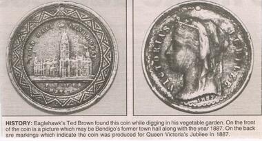
... : Eaglehawk's Ted Brown found this coin while digging in his vegetable...: Eaglehawk's Ted Brown found this coin while digging in his vegetable ...BHS CollectionBendigo Advertiser ''The way we were'' from 2003. History: Eaglehawk's Ted Brown found this coin while digging in his vegetable garden. On the front of the coin is a picture which may be Bendigo's former town hall along with the year 1887. On the back are markings which indicate the coin was produced for Queen Victoria's jubilee in 1887. The clip is in a folder.newspaper, bendigo advertiser, the way we were -
Glen Eira Historical Society
Document - St. Anthony’s School, Glen Huntly
... photograph with caption from St. Anthony’s School re a vegetable... a vegetable garden project. St. Anthony’s School Glenhuntly Catholic ...This file Contains three items from the Caulfield Leader. Two enrolment advertisements dated 08/03/2011 and 06/03/2012 for St. Anthony’s School Glenhuntly – includes facilities and programs. A newspaper cutting dated 29/03/2011 – includes photograph with caption from St. Anthony’s School re a vegetable garden project.st. anthony’s school glenhuntly, catholic school, primary school, advertisement, newspaper, teacher, community garden, rawson jordan, oakleigh south bunnings, little veggie patch, bendigo community bank caulfield -
 Sunbury Family History and Heritage Society Inc.
Photograph, Bulla Primary, 1994
... a vegetable garden. The first classroom to be built was a bluestone... equipment and laying our the school garden to include a vegetable ...There are a series of photographs in the collection which featured school improvements which were carried out on the building and the grounds in 1994 at the Bulla Primary School No. 46. The improvements included painting the school buildings, installing new playground equipment and laying our the school garden to include a vegetable garden. The first classroom to be built was a bluestone building, which opened in 1870. Two years after these improvements took place the Bulla Primary School was closed.A coloured photograph of one of the classrooms at the Bulla Primary School.bulla primary school, school improvements, school grounds -
 University of Melbourne, Burnley Campus Archives
Photograph - Black and white print, Publicity Branch Victorian Department of Agriculture, Students Working in Orchard, 1964
... and vegetable garden at Burnley. The grass sward in the foreground... of the orchard and vegetable garden at Burnley. The grass sward ...Note by T.H. Kneen 8 April 1992, "Operator on tractor could be Alan McLennan (Garden Instructor 1954-1969.) The citrus planting was established by Ray Harding (Dec 1958) therefore 1954-58. Students (3) not clear." Appears in article by T H Kneen (1964) B93.655 with caption "A general view of the orchard and vegetable garden at Burnley. The grass sward in the foreground is controlled by mechanical mowing and chemical weedicides."2 copies black and white photograph, one an enlargement. 3 students working in the Citrus Block of the Orchard. One is spraying from a backpack, one is mowing using a tractor and one is pruning.On reverse, "Photograph by Publicity Branch Department Of Agriculture Ref. No. D572B."alan mclennan, garden instructor, ray harding, burnley gardens, citrus trees, students working outside, orchard, tractor, spraying, mowing, pruning, publicity -
 Dutch Australian Heritage Centre Victoria
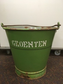
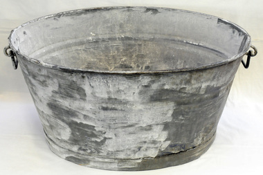
Vegetable Bucket (Groenten Emmer)
... Vegetables buckets were used to collect vegetables from... vegetables from the garden, greengrocer or other supplier. The item ...Vegetables buckets were used to collect vegetables from the garden, greengrocer or other supplier.The item speaks of a time when people either grew their own food or bought it from delivery carts.The metal bucket is enamelled in green on the outside and grey on the inside. It has a plain handle.The word "GROENTEN" (vegetables) in white enameling underlined by 3 gold rings that go right around the bucket. -
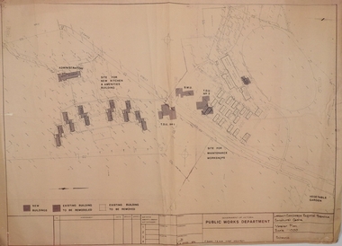 Bendigo Historical Society Inc.
Plan - SANDHURST BOYS CENTRE COLLECTION: MASTER PLAN
... for maintenance workshops, vegetable garden. Also shows a residence... workshops, vegetable garden. Also shows a residence, garage ...Government of Victoria. Public Works Department. Master plan for the Loddon-Campaspe Regional Service Sandhurst Centre. [produced by] J Swan Chief architect, approved by B.W. Swan. Shows a brick Administration building, 6 [accommodation?] brick buildings (to be remodelled), the site for a new kitchen & amenities building, TDU no 1, BMU, TDU no 2 (new buildings), sites for maintenance workshops, vegetable garden. Also shows a residence, garage, recreation oval, with 3 existing weatherboard buildings, galvanised iron building, a weatherboard grandstand, a galvanised iron shed, fowl shed, 14 galvanised iron buildings [probably Nissan huts] and 2 toilet blocks. Location unknown 16.02.2023.bendigo, institutions, sandhurst boys centre, victoria public works dept; plans; sandhurst boys centre; j.swan -
 Bayside Gallery - Bayside City Council Art & Heritage Collection
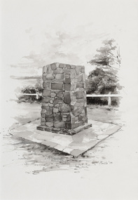
Work on paper - ink and watercolour, Annette Meikle, Moysey Memorial, 1977
... vegetable gardens. They later purchased the land and named... vegetable gardens. They later purchased the land and named ...In 1977, artist Annette Meikle undertook a commission to illustrate a book recording stories of places and people in the Bayside area. It was published in 1978 as Sandringham Sketchbook, with text by Elizabeth Waters. The sketches were intended to record remaining examples of Bayside’s early architecture and environment, as well as reflect newer architectural changes. Meikle went on to donate 22 of these sketches to Bayside City Council in 2003. Erected in 1964, this stone cairn on Beach Road in Beaumaris marks the site of the wattle and daub cottage of James and Susannah Moysey. James, Susannah and their cousin Nicholas arrived in Victoria in 1844 and leased land on the cliff-top. They built a cottage, cleared the land for sheep and cattle and established vegetable gardens. They later purchased the land and named it Beaumaris Park, derived from the name of the Welsh coastal resort where Edward I built Beau Marais castle.Annette Meikle, Moysey Memorial 1977, ink and watercolour, 35 x 23.5 cm. Bayside City Council Art and Heritage Collection. Donated by the artist, 2003annette meikle, sandringham sketchbook, elizabeth waters, port phillip bay, moysey memorial, coastline, stone cairn, james and susannah moysey, beaumaris -
 Surrey Hills Historical Society Collection
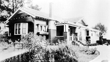
Photograph, 'Strathmore' 75 Victoria Crescent, Mont Albert
... remained rural with sheep, an orchard and vegetable garden, he laid... part remained rural with sheep, an orchard and vegetable garden ...‘Strathmore’ Victoria Crescent (dem.) Joseph Sutton Crow and his wife Jessie (nee Temby) bought this property which had belonged to the Purbrick family in 1924. Sutton was an amateur ‘planner and landscape designer’ and had much pleasure in planning the use of their garden of 100 feet by 400 feet. While part remained rural with sheep, an orchard and vegetable garden, he laid out sweeping designs for the front garden which Jessie enjoyed converting into a garden worthy of display and which did gain prizes in the Herald Garden competitions of the 1930s. They entertained friends and often had as guests University Conservatorium staff and visiting musical personnel. They also opened the garden for local church fund-raising functions. Children, Jean and Ray, had areas set out for their recreation with pets and activities areas. The donor was their daughter. A black and white photograph of a Californian Style weatherboard house, painted in a dark colour. There is a well established garden in front. There is a bay window at one side of the house.house names, californian bungalow style, weatherboard, victoria crescent, surrey hills, (mr) joseph sutton crow, (mrs) jessie sutton crow, purbrick family, 1924, herald garden competitions, 1930-1939, (miss) jean sutton crow, (mr) ray sutton crow, 'strathmore' -
The Beechworth Burke Museum
Audio - Oral History, Jennifer Williams, Mrs Helen Jackson, 9th March 2000
... with the Mayday Hills asylum as a vegetable gardener. Living in Beechworth... with the Mayday Hills asylum as a vegetable gardener. Living in Beechworth ...Mrs. Helen Jackson, originally from Melbourne, moved to Beechworth in the 1950s for the purpose of her husband's employment with the Mayday Hills asylum as a vegetable gardener. Living in Beechworth for over 40 years, Mrs. Jackson spent her time as a devoted full-time mother raising her family of biological and foster children where she has fond memories of Beechworth being a safe and fun place to live - "Oh it was, life was fun!". This oral history recording was part of a project conducted by Jennifer Williams in the year 2000 to capture the everyday life and struggles in Beechworth during the twentieth century. This project involved recording seventy oral histories on cassette tapes of local Beechworth residents which were then published in a book titled: Listen to what they say: voices of twentieth century Beechworth. These cassette tapes were digitised in July 2021 with funds made available by the Friends of the Burke.The oral history record of Mrs. Helen Jackson is a representative insight into life in Beechworth from the 1950s onwards, specifically in the descriptions of commerce, business, family, and leisure activities for residents of the town during the post-war period until the present day. Mrs. Jackson's recollections have a social value to the town of Beechworth as a local perspective on its development and contributes to its cultural and social history. This oral history account is socially and historically significant as it is a part of a broader collection of interviews conducted by Jennifer Williams which were published in the book 'Listen to what they say: voices of twentieth-century Beechworth.' While the township of Beechworth is known for its history as a gold rush town, these accounts provide a unique insight into the day-to-day life of the town's residents during the 20th century, many of which will have now been lost if they had not been preserved.This is a digital copy of a recording that was originally captured on a cassette tape. The cassette tape is black with a horizontal white strip and is currently stored in a clear flat plastic rectangular container. It holds up 40 minutes of recordings on each side.Mrs Helen Jackson /listen to what they say, beechworth, oral history, burke museum, jackson, helen jackson, linda peacock, mayday hills -
 Lakes Entrance Historical Society
Photograph - gold mining town of Grant Victoria, 1900 c
... Black and white photograph of a vegetable patch and flower... photograph of a vegetable patch and flower garden beside a rustic ...Black and white photograph of a vegetable patch and flower garden beside a rustic dwelling surrounded by split paling fence near the gold mining town of Grant Victoriamines and mining, settlement, topography, gold -
 Kiewa Valley Historical Society
Photos - Mt Beauty Buildings in 1973. Set of 8, 1973
... run amok and vanquished the vegetable garden and citrus trees... run amok and vanquished the vegetable garden and citrus trees ...The shopping centre in Mt Beauty, both buildings and streetscape, have undergone significant changes since 1973. The kindergarten has undergone extensive remodelling, The Chalet has been replaced by Svarmisk Resort and Accommodation Spa. Tawonga hospital has undergone extensive renovation and is now Mt Beauty Hospital AND Kiewa Valley House. The Workman’s Club changed name to the Country Club and has since closed down. Hospital and Kiewa Valley House now occupy what is shown as a vacant lot opposite the motel which is now called Mt Beauty Motor Inn.The houses in Mt Beauty were brought in by the State Electricity Commission of Victoria when they constructed Mt Beauty Town for their workers building the Kiewa Hydro Electric Scheme. Mt Beauty is unique began as a construction town in the late 1940's.Colour photographs of various buildings in Mt Beauty taken in 1973 1. Workman’s Club 2. View over the pondage 3. Tawonga Hospital (Mt Beauty) 4. Mt Beauty Chalet 5. Mt Beauty Kindergarten 6. The Merjei Motel 7. 8 Valley Avenue 8. Shopping Centre Handwritten in ink on the back of photos 1. Workman’s Club 1973 (after the brick makeover) From the sports oval – the high school is to the right 2. A view over the pond 1973 3. Tawonga Hospital 1973 (Mt Beauty) 4. Mount Beauty Chalet 1973 5. Kindergarten 1973 6. The Merjei Motel 1973 7. Our house at 8 Valley Ave 1973, Owner after us erected the car port, let the front hedge run amok and vanquished the vegetable garden and citrus trees Dad created. 8. Shopping Centre 1973. At the end of the street is the hospital (believe it is now Mt Beauty Bush Nursing Hotel) mt beauty, workman's club, chalet, tawonga hospital -
Ringwood and District Historical Society
Document, Ringwood and District Horticultural and Garden Club, City of Ringwood Garden Competition 1972, Entry Form, 1972
... . Vegetable Garden. Section 7. Native Garden or other than floral.... Section 5. New Garden (under 3 years) Section 6. Vegetable Garden ...City of Ringwood Garden Competition 1972 Entry Form by the Ringwood and District Horticultural and Garden Club.Typed formCity of Ringwood Garden Competition 1972 Entry Form Section 1. Open (Gardener employed) Section 2. Amateur, over 60 feet Section 3. Amateur, under 60 feet. Section 4. Front Garden. Section 5. New Garden (under 3 years) Section 6. Vegetable Garden. Section 7. Native Garden or other than floral. Section 8. Special section. Gardeners over 65 years. Name: ...................................... Address: ........................................... Section No. Please complete and return before 23rd. February 1972 to Mrs. V.H.Wilson, Secretary, Ringwood & District Horticultural and Garden Club, 38 William St Ringwood. 3134. -
 Orbost & District Historical Society
wash tub, 1900-1910
... been “recycled”by being poured onto vegetable gardens... been “recycled”by being poured onto vegetable gardens and fruit ...This item was bought by George Henry Douglas Russell when he married Hilda Raymond, a parson's daughter, in 1920. This galvanised metal wash tub was manufactured for domestic use prior to household plumbing, running water or waste removal in Australian homes. On farms in the late 19th / early 20th centuries there were no built-in coppers and concrete troughs with reticulated water. Thus the washing for the family of five daughters was done with this tub. .Tubs of this type vary in size and were used for washing dishes (It was the “ kitchen sink”) or for washing smaller items of clothing “the delicates”. This tub could also have been used to bathe the children. The water was heated on a wood fired stove, then carried to the tub. This could be a lengthy and physically demanding exercise. Much more labor intensive than loading the dishwasher. After use the water may have been “recycled”by being poured onto vegetable gardens and fruit trees. Later at harvesting this tub held maize and beans to top up the three bushel bags of the threshing machines. This was before the hand sewing of the top of the bags with needle and twine.This tub is an indication that items for domestic use in the early 20th century were “made to last” and not manufactured for planned obsolescence.A large galvanized iron was tub, circular with the sides tapering slightly to the flat base. It is seamed on both sides, made from two shets of iron. The base has been soldered on. and the top rim is folded. On either side handles are rivetted on.domestic laundry was-tub galvanized-iron -
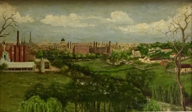 Kew Historical Society Inc
Painting - Panoramic View of Kew and Abbotsford from the garden of Rockingham, V Maloney, 1952
... a three-acre vegetable garden within the formal terraced gardens... a three-acre vegetable garden within the formal terraced gardens ...The extensive formal landscaped gardens of Rockingham had been created in the 1860s, and by the 1950s remained bordered to the south by the Barkers Road cutting, and to the north by Blytheswood, the neighbouring Syme family property, By 1940, the Syme family were no longer the occupiers of Rockingham. John Herbert Syme had died in October 1939, and by August the following year, his wife had made the house and garden available, rent free to the Red Cross as a convalescent home for Australian soldiers injured in the Second World War. At the time, the house was described as containing twenty rooms, including a ballroom and a billiards room, with a garden of eight acres overlooking the Yarra. The task of renovating the house to conform to its new function as a convalescent home took a year, finally opening in August 1941. Community support for Rockingham was widespread and included the decision by the National Gallery of Victoria to loan pictures from its collection to decorate the walls. Calls were made for women around Victoria to donate fruit and vegetables from their gardens, which the railways agreed to freight for free. Other local support included the work by a team of boys to establish a three-acre vegetable garden within the formal terraced gardens. From the beginning, occupational therapy formed a key component of the rehabilitation of psychologically injured soldiers. This is confirmed by contemporary newspaper accounts of weaving, ironwork, leatherwork, basketry and gardening by patients. Numerous photographs, held by the Australian War Memorial (AWM) and the State Library of Victoria (SLV), record the importance of these rehabilitation activities. The painting of the view across the river to Abbotsford may have been painted in one of these occupational therapy sessions. For many decades it hung in the occupational therapy room. It must have been on view following the sale of Rockingham by the Syme family to the Red Cross in 1955, and subsequently, until the house was demolished and its grounds finally subdivided in 1977.View of Abbotsford from the garden of Rockingham (1952) was created by V Maloney. The vantage point of the artist was the garden of Rockingham, one of two mansions overlooking the Yarra owned by the Syme family. The artwork depicts a number of sites - especially factories - that have since been demolished.Signed by the artist, lower right "V Maloney"rockingham red cross convalescent home, hospitals - kew (vic), rosemary lade, art therapy -
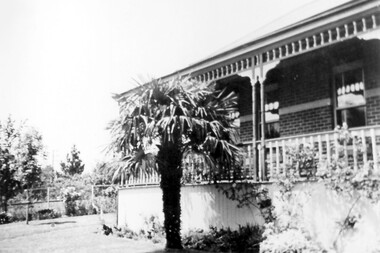 Surrey Hills Historical Society Collection
Photograph, 3 Beatty Street, Mont Albert
... /3 hectare with a formal garden, vegetable garden, orchard..., vegetable garden, orchard and chicken run. Augustin had a life-long ...Location is now 3 Beatty Street, Mont Albert although electoral entries for the Lodewyckx family in the 1930s give the address as 1 Beatty Street. This address is a more contemporary house and part of the original garden was subdivided off at some stage. The property's original address was 1 Victoria Street, renamed in 1917. The house was built c 1891 and from then until 1905 it was home to Leopold A Carter (dentist of Collins Street); followed by James J Hempill (broker) from 1905 -1907. he called it 'Manchling'. There were several other owners or tenants before the Lodewyckx family moved into it in 1920. They named the property 'Huize Eikenbosch' (Dutch meaning House of Oaks). It was set in 1/3 hectare with a formal garden, vegetable garden, orchard and chicken run. Augustin had a life-long interest in growing vegetables and planted many European trees, especially oaks. Augustin Lodewyckx was born and educated in Belgium, was appointed Professor of Modern Languages at Stellenbosch, South Africa and later joined the Belgium Colonial Service. In 1915 he commenced as lecturer in German at Melbourne, becoming Associate Professor in 1923. He had married Anna Sophia Hansen* in South Africa in 1910. They had 2 children Karel Axel, librarian of the University of Melbourne, and daughter Hilma Dymphna, translator, editor and wife of Manning Clark, historian. In 1942 Augustin introduced a university course in Dutch and also undertook research into German immigration to Australia. He retired in 1946 and died in 1964. (*Thought to be nick-named Mina.) A black and white photograph of a corner of a house with a large palm tree in front. There is decorative wooden balustrading on the verandah.beatty street, mont albert, mina lodewyckx (mrs), augustin lodewyckx (mr), karel axel lodewyckx (mr), axel lodewyckx (mr), anna sophia lodewyckx (mrs), hilma dymphna lodewyckx (miss), dymphna lodewyckx (miss), hilma dymphna clark (mrs), dymphna clark (mrs), architectural features -
 Kew Historical Society Inc
Plan, Melbourne & Metropolitan Board of Works : Borough of Kew : Detail Plan No.1581, 1904
... , this land is noted by the contractor as used for vegetable gardens.... for vegetable gardens. Melbourne & Metropolitan Board of Works : Borough ...The Melbourne and Metropolitan Board of Works (MMBW) plans were produced from the 1890s to the 1950s. They were crucial to the design and development of Melbourne's sewerage and drainage system. The plans, at a scale of 40 feet to 1 inch (1:480), provide a detailed historical record of Melbourne streetscapes and environmental features. Each plan covers one or two street blocks (roughly six streets), showing details of buildings, including garden layouts and ownership boundaries, and features such as laneways, drains, bridges, parks, municipal boundaries and other prominent landmarks as they existed at the time each plan was produced. (Source: State Library of Victoria)This plan forms part of a large group of MMBW plans and maps that was donated to the Society by the Mr Poulter, City Engineer of the City of Kew in 1989. Within this collection, thirty-five hand-coloured plans, backed with linen, are of statewide significance as they include annotations that provide details of construction materials used in buildings in the first decade of the 20th century as well as additional information about land ownership and usage. The copies in the Public Record Office Victoria and the State Library of Victoria are monochrome versions which do not denote building materials so that the maps in this collection are invaluable and unique tools for researchers and heritage consultants. A number of the plans are not held in the collection of the State Library of Victoria so they have the additional attribute of rarity.Original survey plan, issued by the MMBW to a contractor with responsibility for constructing sewers in the area identified on the plan within the Borough of Kew. The plan was at some stage hand-coloured, possibly by the contractor, but more likely by officers working in the Engineering Department of the Borough and later Town, then City of Kew. The hand-coloured sections of buildings on the plan were used to denote masonry or brick constructions (pink), weatherboard constructions (yellow), and public buildings (grey). The streets and built structures in this plan were surveyed in 1903 and released to contractors in 1904. In addition to the designation of building types by colour, the plan includes detailed descriptions of land use and ownership. While many buildings remain from this period, a number of the buildings represented have been demolished including the original Kew Town Hall, and the Congregational and Roman Catholic churches in Walpole Street. While the mansion ‘Illapa’ in Princess Street is still extant – now part of ‘Rylands’ – the neighbouring mansion ‘Elsmere’ was demolished some decades ago. Rivalling Illapa and Elsmere in size were two mansions in Walpole Street, one named on the plan as ‘Gnarlbine’. Over time, Kew Junction and the south side of High Street have been reconfigured and widened, so that the commercial buildings on the corner of Princess and High Street no longer exist. A surprising feature of this part of central Kew to the northwest of Kew Junction is the amount of vacant land. In a number of cases, this land is noted by the contractor as used for vegetable gardens.melbourne and metropolitan board of works, detail plans, maps - borough of kew, mmbw 1581, cartography -
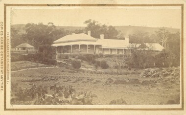 Bacchus Marsh & District Historical Society
Photograph, Glenmore Homestead 1883
... a garden. At the front there is a vegetable garden which seems... leading through a garden. At the front there is a vegetable garden ...This homestead was built by Charles Griffith on a 55,000 acre Run. It replaced an earlier dwelling which was a slab hut with a bark roof. Charles Griffith, an Irish barrister, with his friend, James Moore, settled on Glenmore Station in the Parwan Valley in 1840. Their partnership lasted until 1848. In 1846, whilst in Ireland, Griffith married Miss Jane Catherine Magee, then returned to Glenmore and later took his nephew, Molesworth Richard Greene, into partnership, which arrangement proved to be long and prosperous. In 1857, they bought runs at Mount Hope and Mount Pyramid, which they kept until the days of free selection. Griffith led an active and successful public life.He was a member of the new Victorian Legislative Council in 1851, and was later an elected representative of the Legislative Assembly 1853-1859. He occupied many important public positions, including that of magistrate for Bacchus Marsh. Griffith was a devout Anglican and hosted Bishop Charles Perry at his station near Bacchus Marsh in 1849. He died in 1863 at his home in South Yarra.Small sepia unframed photograph on card with gold border framing photograph. Housed in the album, 'Photographs of Bacchus Marsh and District in 1883 by Stevenson and McNicoll'. The photograph shows a view of an extensive single-storey homestead consisting of three adjoining buildings, with a further building on the left of the main property. The series of three buildings is built in an elevated position, with pathways leading through a garden. At the front there is a vegetable garden which seems to be still in a state of development. The main house, possibly of brick, is set at an angle to the other two in this complex. It has a hip roof with a concave verandah on two sides with arched barge boards and simple unadorned pillars. There appears to be a hammock slung between two pillars. Two chimneys can be seen on this dwelling.The adjoining building is of a simpler design, with a lower roof line and a verandah running along the front. Two chimneys can be seen, one emitting smoke. This middle building may be a kitchen and rooms for day-to-day use. The third building is also of a simpler design, with a gable above a verandah. The purpose of this building is less clear. The different styles of construction suggest that these buildings were built separately at different times for different purposes. To the left of the main group of buildings is another cottage, smaller and of a simpler design. A fence runs along the front, clearly separating this building from the others, suggesting it may have been the dwelling of an overseer.On the front: Stevenson & McNicoll. Photo. 108 Elizabeth St. Melbourne. COPIES CAN BE OBTAINED AT ANY TIME. On the back: LIGHT & TRUTH inscribed on a banner surmounted by a representation of the rising sun. Copies of this Portrait can be had at any time by sending the Name and Post Office Money Order or Stamps for the amount of order to STEVENSON & McNICOLL LATE BENSON & STEVENSON, Photographers. 108 Elizabeth Street, MELBOURNE. stevenson and mcnicoll 1883 photographs of bacchus marsh and district, farms bacchus marsh, charles james griffith 1808-1863, glenmore station -
 Kew Historical Society Inc
Plan, Melbourne & Metropolitan Board of Works : Borough of Kew : Detail Plan No.1588, 1904
... by 1903 a number of sites were still used as vegetable gardens... by 1903 a number of sites were still used as vegetable gardens ...The Melbourne and Metropolitan Board of Works (MMBW) plans were produced from the 1890s to the 1950s. They were crucial to the design and development of Melbourne's sewerage and drainage system. The plans, at a scale of 40 feet to 1 inch (1:480), provide a detailed historical record of Melbourne streetscapes and environmental features. Each plan covers one or two street blocks (roughly six streets), showing details of buildings, including garden layouts and ownership boundaries, and features such as laneways, drains, bridges, parks, municipal boundaries and other prominent landmarks as they existed at the time each plan was produced. (Source: State Library of Victoria)This plan forms part of a large group of MMBW plans and maps that was donated to the Society by the Mr Poulter, City Engineer of the City of Kew in 1989. Within this collection, thirty-five hand-coloured plans, backed with linen, are of statewide significance as they include annotations that provide details of construction materials used in buildings in the first decade of the 20th century as well as additional information about land ownership and usage. The copies in the Public Record Office Victoria and the State Library of Victoria are monochrome versions which do not denote building materials so that the maps in this collection are invaluable and unique tools for researchers and heritage consultants. A number of the plans are not held in the collection of the State Library of Victoria so they have the additional attribute of rarity.Original survey plan, issued by the MMBW to a contractor with responsibility for constructing sewers in the area identified on the plan within the Borough of Kew. The plan was at some stage hand-coloured, possibly by the contractor, but more likely by officers working in the Engineering Department of the Borough and later Town, then City of Kew. The hand-coloured sections of buildings on the plan were used to denote masonry or brick constructions (pink), weatherboard constructions (yellow), and public buildings (grey). This plan shows the original configuration of the Kew Post Office, Court House and Police Station, which had opened in 1888. This configuration was to essentially remain until the purchase of the Court House and Police Station by the City of Boroondara in 2007 and its subsequent renovation. Interestingly, the MMBW surveyors incorrectly labelled parts of the complex. In the triangle in front of the Post Office, before the erection of the Kew Cenotaph in 1925, was located a lawn and the Queen Victoria Jubilee Fountain. While many of the shops on the south side of High street had been constructed by 1903 a number of sites were still used as vegetable gardens. Further along High Street, on the corner of Charles Street, the Salvation Army Barracks can be seen on the plan. These Barracks predate the later Citadel and ‘Young People’s Hall’ that were opened in 1919. At 22 Charles Street can be seen the house of James Venn Morgan. Hailed as the ‘father of Kew’, Morgan arrived in Melbourne in 1840. He was first engaged as a bookmaker, but a fortunate venture on the goldfields enabled him to purchase land in Kew. He conducted a market garden and dairy in Kew for many years.melbourne and metropolitan board of works, detail plans, maps - borough of kew, mmbw 1588, cartography -
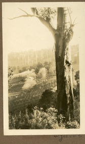 Mt Dandenong & District Historical Society Inc.
Photograph
... ' and twenty acres of land. He turned this into a commercial garden... this into a commercial garden. Firstly vegetables then later flowers and shrubs ...The W. JEEVES in the inscription would be Walter Jeeves. Walter Jeeves was the second son of Ellis Jeeves and the grandson Of Isaac the Pioneer. Walter had been given the house 'Kalorama' and twenty acres of land. He turned this into a commercial garden. Firstly vegetables then later flowers and shrubs. The land was sloping. Walter married Dorothy Hayes and had four daughters. When Walter died in 1960 the property was put up for sale and it was eventually purchased for the State through the efforts of the Save the Dandenongs League. This photograph is from the album of Ivy May Child so would have been taken between 1927 - 1932.Sepia coloured photograh with a tall gum tree in the foreground and a large homestead in the centre of the photograph surrounded by orchards.Written below the photograph in the album: W. JEEVESwalter jeeves, dorothy hayes, save the dandenongs league, kalorama -
 Eltham District Historical Society Inc
Photograph - Digital Photograph, Marguerite Marshall, Sutherland Home for Children, Diamond Creek, 27 September 2007
... she bequeathed this, including the house, orchards, vegetable... she bequeathed this, including the house, orchards, vegetable ...The Sutherland Homes for Children on Yan Yean Road, Diamond Creek cared for thousands of children from when it was opened in 1912. The site closed for this purpose in 1991 and was sold and later developed for commercial and office purposes. Covered under Heritage Overlay, Nillumbik Planning Scheme. Published: Nillumbik Now and Then / Marguerite Marshall 2008; photographs Alan King with Marguerite Marshall.; p107 The Sutherland Homes for Children at 14 Yan Yean Road, Diamond Creek, cared for thousands of children since they opened in 1912, after beginning at La Trobe Street, Melbourne in 1908. In 1994 Sutherland Homes (then called Sutherland Child, Youth and Family Services) amalgamated with Berry Street Child and Family Welfare. Together as Berry Street Victoria, they formed Victoria’s largest independent provider of support and accommodation services for children, young people and families in crisis.1 However with the move from institutional to community care, the Diamond Creek site had not been used since 1991 and was sold to private purchasers in 1999. More than 2000 former residents, staff, neighbours and friends attended a farewell in February, 2000.2 The Sutherland Homes red-brick and stuccoed building in Diamond Creek (a rare design in the Eltham Shire), was opened in 1929 by Lord Somers, the Governor of Victoria. Destitute children lived in dormitories bathed in natural light through large windows. However in 1958 as the cottage–parent system replaced the dormitory system, the first of eight residential cottages accommodating ten to 12 children was built. The site also included Special School 3660 and a farm, and the children were able to form relationships with people outside Sutherland, by staying with holiday hosts. Children were originally placed at Sutherland because of extreme poverty, or because single parents could not cope. However later, most placements occurred due to family violence, abuse or neglect. The property was originally bought from the Crown in 1869 by Timothy Mahony. Later owner, Augusta Meglin, ran a 40-acre (16ha) farm there. In 1909 she bequeathed this, including the house, orchards, vegetable gardens, vineyards and the balance of her income to The Sutherland Homes for Neglected Children. Sutherland Homes’ founder, Selina Sutherland, was known as ‘New Zealand’s Florence Nightingale’. In 1888 she became Victoria’s first licensed ‘child rescuer’3 and was to rescue around 3000 waifs from Victoria’s streets and slums.4 Born in Scotland in 1839, Sutherland joined her sister, who had emigrated with her husband to New Zealand. Sutherland trained as a nurse and led the establishment of a public hospital at Masterton. In 1881, while holidaying in Melbourne, Sutherland was so touched by seeing young people living under Princes Bridge, that this determined her future work. Meanwhile Sutherland instigated the Melbourne District Nursing Society, (now Royal District Nursing Service). She also led the founding of The Victorian Neglected Children’s Aid Society (now Oz Child) and the Presbyterian Neglected Children’s Aid Society (now Kildonan). From 1894 Miss Sutherland was Melbourne’s best known woman and cut a distinctive figure, wearing an alpine hat with a prominent feather. In 1906 Prime Minister Alfred Deakin named her Melbourne’s most successful philanthropic worker. However she was to face some difficult times. That year she suffered severely from an injured shoulder and dizzy turns and was pressured to resign as Superintendent of The Victorian Neglected Children’s Aid Society. In 1908 the committee of management offered her 12 months leave with pay. Sutherland declined – but soon after, was dismissed. However she continued her work from Latrobe Street, Melbourne, with the help of Sister Ellen Sanderson and several committee members. Sutherland attempted to register her new organisation but the Victorian Neglected Children’s Aid Society objected to the government, alleging that Sutherland, because of increasing infirmity, was unable to satisfactorily carry out such duties. They accused her of cruelty and of intoxication. However the charges were not proven, so The Sutherland Homes for Neglected Children was registered.5 Sadly, in 1909 Sutherland died, the day she was to move the children to the ‘country property’ at Diamond Creek. At her death she owned less than £10. Today Berry Street recognises Sutherland’s enormous contribution to child welfare with a memorial and an annual Selina Sutherland Award, presented to an outstanding volunteer.This collection of almost 130 photos about places and people within the Shire of Nillumbik, an urban and rural municipality in Melbourne's north, contributes to an understanding of the history of the Shire. Published in 2008 immediately prior to the Black Saturday bushfires of February 7, 2009, it documents sites that were impacted, and in some cases destroyed by the fires. It includes photographs taken especially for the publication, creating a unique time capsule representing the Shire in the early 21st century. It remains the most recent comprehenesive publication devoted to the Shire's history connecting local residents to the past. nillumbik now and then (marshall-king) collection, diamond creek, sutherland home for children -
 University of Melbourne, Burnley Campus Archives
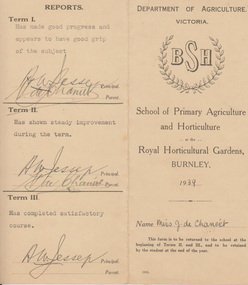
Card - Report Card, Dept of Agriculture, Victoria, Department of Agriculture, Victoria BSH, School of Primary Agriculture and Horticulture at the Royal Horticultural Gardens, Burnley Report Card, 1939
... , Chemistry, Gardening, Entomology, Vegetable Pathology, Viticulture..., Vegetable Pathology, Viticulture, Citriculture, Garden Design ...Miss June De Chaneet, Terms I, II and III 1939. She graduated with a Certificate of Competency in Horticulture in 1939Report Card of Miss June de Chaneet, Terms I, II and III 1939. Lists subjects taken. Miss J.D. Chaneet graduated in Certificate of Competency in Horticulture 1939. Subjects taken: Botany, Chemistry, Gardening, Entomology, Vegetable Pathology, Viticulture, Citriculture, Garden Design, Outdoor Work, Garden observation. Note by T. H. Kneen 1/4/92 "This report card show the name of the school as it was known from the time of Mr. McLennan's appointment in 1916. See B91 228 - on the sign Horticulture takes precedence over Primary Agriculture. The location Royal Horticultural Gardens owes its origin to the Royal Horticultural Society of Victoria which relinquished management of the Gardens to the Department of Agriculture in 1891." "I would have thought the use of Royal was for the RHSV exclusively." THKThe report is signed by the principal A.W. Jessop and Miss de Chaneet's parent V. de Chaneet.certificate of competency, june de chaneet, report card, subjects -
 Eltham District Historical Society Inc
Photograph - Digital Photograph, Marguerite Marshall, Smith Dam, Karingal Drive, Eltham, 19 September 2006
... supply for their cattle, pigs, chickens, orchard and vegetable... supply for their cattle, pigs, chickens, orchard and vegetable ...The dam at the entrance to the Nerreman Gateway in Eltham was built according to an internationally acclaimed theory developed by the builder's father. In 1920, Victorian engineer B.A. Smith was awarded the American Society of Civil Engineers J. James R. Cross Gold Medal for his Technical Paper titled 'Arched Dams'. It was the first time this medal had been awarded outside the United States. The concrete arched dam across the Eltham West Drain was built in 1940 by B.A. Smith's son and engineer, D. B. (Bernie) Smith to water the 24 acre (9.75 ha) hobby farm owned by himself and new wife, Isa Smith. Upon completion of the dam a pump-house was constructed beside the creek but before the water could be pumped up the hill they had to dig a trench and lay 500m of 100mm water main to an elevated holding tank. The Smiths made the pump-house their home for several years until they constructed their home at the top of the hill overlooking Eltham and views extending to Kinglake. Following Bernie's death in 1983, Nerreman Park was subdivided between 1993 and 1995. Gordon Ford designed the landscaping and the pump-house was demolished. Covered under Heritage Overlay, Nillumbik Planning Scheme. Published: Nillumbik Now and Then / Marguerite Marshall 2008; photographs Alan King with Marguerite Marshall.; p137 The dam at the entrance to the Nerreman Gateway in Eltham, was built according to an internationally acclaimed theory developed by the builder’s father. In 1920, Victorian engineer B A Smith was awarded the American Society of Civil Engineers J. James R. Croes Gold Medal, for his Technical Paper titled Arched Dams. It was the first time this medal had been awarded outside America. An international example of the application of Smith’s work can be found in the design of the Hoover Dam on the Colorado River, Nevada, USA. Built between 1930 and 1936, it is recognised by the ASCE as one of ‘America’s Seven Modern Civil Engineering Wonders’.1 The concrete arched dam across the Eltham West Drain was built by B A Smith’s son and engineer, D B (Bernie) Smith. Bernie’s dam followed his father’s theory, having a curvature that takes maximum advantage of concrete’s great strength in compression. The water load is carried into the abutments because of this curvature, which permits a wall thickness of only 225 millimetres thick at its crest, despite the dam’s capacity of more than 4.5 megalitres. The Eltham dam was designed to water the 24 acre (9.75 ha) hobby farm belonging to newly married couple Bernie and Isa Smith. Bernie, from Armadale, and Isa, from a farm at Tyntynder near Swan Hill, were attracted to the hilly topography and the creek running through the property. It extended from Ryans Road, Eltham, to Karingal Drive, Montmorency and was adjacent to Meruka Park. The Smiths named it Nerreman Park using the Aboriginal word Nerreman meaning ‘River Bend’ as their creek had a pronounced bend.2 In 1940 the first thing Bernie did was to build a dam, and with Isa’s help, a pump-house, to secure a water supply for their cattle, pigs, chickens, orchard and vegetable gardens. It was also available for the fire-plugs, which they placed all over the property in case of bushfire. The couple built the pump-house beside the creek and installed a Tange three-plunger pump, which had originally supplied the City of Wodonga with water. But before the Smiths could pump water up the hill from the dam they had to dig a trench and lay about 550 yards (500m) of a four-inch (100mm) water main up to an elevated holding tank. The trench was dug with a single furrow plough drawn by an old draught horse. Living in rough conditions did not deter the Smiths, who made the pump-house their home, where they still lived when their first child was born in 1944. They later built their home at the top of their property overlooking Eltham, with magnificent views to Kinglake, the Dandenong Ranges and Melbourne. From 1946 it took them almost 20 years to complete the 36-square house with its 12-foot (3.6m) high ceilings. Material for the concrete roof and walls faced with sandstone, was ripped out of the ground on their property by plough pulled by tandem Clydesdale horses. Isa was a strong woman – two days before their second child was born – she set three huge sandstone boulders in place in the bottom wall of the garage. She also mixed all the cement for the house. A collapsed kitchen wall did not discourage her from rebuilding it in a week, while her husband was away working in the country. She later recalled: ‘We stood back to admire this beautiful wall we’d built and while we were looking at it, it came tumbling down’.3 Following Bernie’s death in 1983, Nerreman Park was subdivided, between 1993 and 1995. Local Gordon Ford designed the landscaping and the pump-house was pulled down. But the dam remains as a reminder of exceptional engineering4 – and of a remarkable couple.This collection of almost 130 photos about places and people within the Shire of Nillumbik, an urban and rural municipality in Melbourne's north, contributes to an understanding of the history of the Shire. Published in 2008 immediately prior to the Black Saturday bushfires of February 7, 2009, it documents sites that were impacted, and in some cases destroyed by the fires. It includes photographs taken especially for the publication, creating a unique time capsule representing the Shire in the early 21st century. It remains the most recent comprehenesive publication devoted to the Shire's history connecting local residents to the past. nillumbik now and then (marshall-king) collection, eltham, karingal drive, smiths dam, bernie smith, gordon ford, isa smith, nerreman gateway, nerreman park estate, dams -
 Eltham District Historical Society Inc
Photograph - Digital Photograph, Alan King, Eltham Living and Learning Centre, 26 January 2008
... and planted fruit trees and a vegetable garden. In the early 1970s... and planted fruit trees and a vegetable garden. In the early 1970s ...In 1857, tanner John Pearson purchased three and a half acres of land in Little Eltham, at the western end of Pitt Street, with a 70-foot frontage to Maria Street (Main Road) and stretching down to the Diamond Creek for £100. He contracted Benjamin Oliver Wallis to build house for him. Wallis, a mason by trade who originated from the Cornish village of Newlyn, migrated to Melbourne in 1853 and was shortly engaged by Richard Warren to build the Eltham Hotel, which opened in 1854. When Warren fell into financial difficulty in 1858, Wallis purchased the hotel. That same year, Pearson constructed a tannery below the house with access to the water in the Diamond Creek. When Pearson became bankrupt in 1867, Wallis similarly acquired the house from Pearson’s creditors in 1868 and lived there until his death in 1896. For some of this time the house was in the name of Wallis’s son Richard but following his death in 1888, ownership reverted to his father. It was purchased by retired teacher Richard Gilsenen in 1899. Gilsenen was made acting head teacher at the Eltham State School in 1906 following the sudden death of head teacher John Brown. In the 1950s the house was bought by retired engineer Dr Alfred Fitzpatrick and his wife Claire who made various modifications to house goats and poultry as well as structural modifications to the house. In the early 1970s, Eltham Shire Councillors Frank Maas and Don Maling proposed an extended communities’ activities program be set up and the Commonwealth Grants Commission was approached for financial assistance. In 1974 a $50,000 Commonwealth Grant was received by the Shire Council to acquire the Fitzpatrick property as part of the planning to establish an extended communities’ activities program. The Fitzpatricks moved next door and Claire taught at the new Living and Learning Centre, which began in 1975, one of the first community education centres in Victoria. Covered under Heritage Overlay, Nillumbik Planning Scheme. Published: Nillumbik Now and Then / Marguerite Marshall 2008; photographs Alan King with Marguerite Marshall.; p59 It’s a centre for sharing knowledge and friendship and it stands on the former hub of Eltham’s original township near Pitt Street. The Eltham Living and Learning Centre, with around 2000 participants a year, began in 1975 as one of the first Community Education Centres in Victoria. Classes ranging from macramé to wine making to environmental living have enriched the lives of thousands of people through the generosity of tutors sharing their skills free of charge. The centre’s heart is the brick cottage, built in 1858 by tanner John Pearson. He bought the three and a half acre (1.4ha) allotment fronting Maria Street (now Main Road) and stretching down to the Diamond Creek. The allotment formed part of a 316 acre (127.8ha) subdivision, owned by Josiah Holloway, called Little Eltham, north of the original Eltham Reserve.1 The allotment then passed through the hands of several speculators before it was sold to Pearson for £100 in 1857. Mr Pearson’s children attended the Eltham Primary School from 1864 to 1867. But creditors took possession of the property when his tannery folded in 1867. It was then sold to publican Benjamin Wallis, who owned the Eltham Hotel at the corner of Pitt Street and Main Road. In 1899 the property was bought by Richard Gilsenan, who became acting head teacher of the Eltham Primary State School in 1906. In the 1950s, retired engineer Dr Alfred Fitzpatrick and his wife Claire bought the property, and made structural changes. Claire, a journalist and community campaigner, modified and built pens for goats and poultry, a stable, a garage and planted fruit trees and a vegetable garden. In the early 1970s a young woman called Carina Hack approached Gwen Wesson at the Diamond Valley Learning Centre (Victoria’s first Community Education Centre) about starting a community centre. Following Wesson’s suggestion, Hack spoke to Shire President Alistair Knox ‘one bleak rainy afternoon, sipping hot drinks and discussing life’.2 Eltham Shire Councillors Frank Maas and Don Maling proposed a community activities program and the council received a $50,000 Commonwealth Government Grant for this venture.3 The Fitzpatricks sold their property to the council and moved next door and Claire taught at the new centre, which Hack named. Eltham obviously wanted such a centre as Hack recalls. ‘During the next two months we had about 50 volunteers working day, night and weekends, scrubbing down, plastering and painting walls, replacing floors, repairing fences, recycling furniture, sewing curtains and cushions, donating furniture, toys, equipment, clean-ing and gardening…’4 The first enrolment day saw a queue stretching up the driveway nearly to the gate and the first sessions attracted 270 people a week. Soon the outbuildings were converted into pottery studios and a large workshop. From 1979 the Eltham Art and Craft Market was held in the centre’s grounds and the Friends of the Centre ran it from 1980. A former program coordinator, Margaret Johnson, remembers enrolment day in the late 1970s and 1980s, when hundreds of people would queue – and some even camped overnight! Overnighters were greeted in the morning with fresh tea and toast. Another tradition was The Enrolment Day Cake with Recipe, given to volunteers. ‘One happy Enrolment Day fell on February 14 and let’s just say that St Valentine found some willing participants, paying $2 for a kiss.’5 Meanwhile the participants’ children could play at the Council Eltham Lower Park house in Hohnes Road, later in Susan Street. But the centre has had difficulties too. In 1990 a fire destroyed the stable and the police suspected arson. However the pavilion was built in its place.This collection of almost 130 photos about places and people within the Shire of Nillumbik, an urban and rural municipality in Melbourne's north, contributes to an understanding of the history of the Shire. Published in 2008 immediately prior to the Black Saturday bushfires of February 7, 2009, it documents sites that were impacted, and in some cases destroyed by the fires. It includes photographs taken especially for the publication, creating a unique time capsule representing the Shire in the early 21st century. It remains the most recent comprehenesive publication devoted to the Shire's history connecting local residents to the past. nillumbik now and then (marshall-king) collection, benjamin oliver wallis, claire fitzpatrick, don maling, dr alfred fitzpatrick, eltham living and learning centre, frank maas, john pearson, richard gilsenen, tannery -
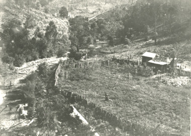
 Orbost & District Historical Society
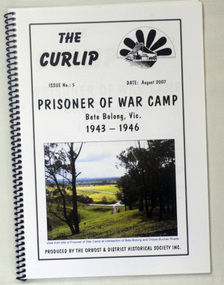
book, The Curlip - P.O.W.Camp Bete Bolong, Vic. 1943-1946, August 2007
... maintained vegetable and flower gardens. They were also skilled... maintained vegetable and flower gardens. They were also skilled ...This is Issue No. 5 of "The Curlip". The magazine is a compilation of research from a trip by the Orbost & District Historical Society to Bete Bolong. The Bete Bolong Prisoner of War Camp was located on the south side of the Buchan - Orbost Rd. From November 1943 to November 1945, Italian prisoners of war were based at Bete Bolong, cultivating maize, peas, beans and other vegetables on local farms. Unlike other 'farming' prisoners of war, those at Bete Bolong did not live with the farming families, but at a Prisoner of War Control Centre on Crown land overlooking the Snowy River Flats. About fifty Italian prisoners lived at the centre, along with an Australian Military Force staff of approximately seven people. The prisoners were driven to and from the farms each day. Three of them apparently simply swam across the river to work. They worked a six day week, with Sundays off. Although they were provided with rations, both prisoners and staff maintained vegetable and flower gardens. They were also skilled at cooking 'anything' they could catch, and at making illegal "grappa". Very few of the Italians were experienced farm workers. Some of them used their skills to make things for the families they worked for; a cabinet-maker made furniture , a cobbler made shoes, etc. They interacted with the local community and, although they were not supposed to go within one kilometre of town, some were found at local dances on Saturday nights. As recreation the prisoners were allowed to walk along the road to the west of the camp. Local people from both sides of the river could hear them sing as they walked. The prisoners also helped to construct an 'ant bed' tennis court on a property adjacent to the centre. Although now overgrown, the site of the tennis court can still be discerned as a flat area above the site of the centre. (ref./vhd.heritagecouncil.vic.gov.au)This item is a useful reference tool on the history of the Prisoner of War Camp at Bete Bolong, Orbost.A spiral bound book with a clear plastic cover. On the front is a coloured photograph of a view from the site of the P.O.W. camp at the intersection of Bete Bolong and Buchan Roads at Bete Bolong. Above is the title "Prisoner of War Camp Bete Bolong, Vic. 1943-1946" in black print on a white background. p.o.w.-camp-orbost ww11 bete-bolong -
Ringwood and District Historical Society
Container, Ringwood Garden Club Inc - Tub of Artefacts and Documents to be catalogued
... , 1964, Best Exhibit in Vegetables. Upwey & District Garden Club..., 1964, Best Exhibit in Vegetables. Upwey & District Garden Club ...RINGWOOD GARDEN CLUB INC. The following is a list of items that are stored at the RDHS Archive site, from the Ringwood Garden Club. This box of items does not include all the archival items from the Club, the Minutes will be kept at the home of the Archive Officer. Medal: From the Royal Horticultural Society of Victoria. Won at Box Hill show, in 1978. Badge: An early Ringwood Horticultural & Agricultural Society badge. Old Photograph: “Judging the Fruit Exhibits”, circa 1908. Certificate: 3rd. Prize at the 2009 Hanging Basket Competition, from the R.H.S.V. Shield: From the National Dahlia Society of Victoria, Annual Inter Society Championship In 1975. Won by the then: Ringwood & District Horticultural Garden Club. Tray: The Bill McDowell Perpetual Trophy for Amateur Cut Flowers: winners from 1973 to 1987. Old Photograph: From the Royal Agricultural Society of Victoria, awarded at the Royal Melbourne Show in 1947, First Prize, Ringwood. Certificate: From the Melbourne City Council: Festival of Progress, held in 1951, to Commemorate the Centenary of Victorian Government. Certificate of Merit: from past winners at shows. (5) Certificates: 2 unused Certificates of Merit, 1 unused Champion certificate. Garden Competition Certificates: from 1959 to 1981. Poster: Early Autumn Show poster displayed in shop Windows. Hortico Prize Certificates: 2 unused, $10.00 & $5.00 value. Tape Recording: Recorded history of the Ringwood Garden Club, talk given by the late Hugh McCall on 23/9/1996, Club’s centenary. Prize Cards: 41 First Prize” cards from Mrs. D. Holloway & 27 “Second Prize” cards, from 1956 to 1960. Prize Cards: 2 First Prize & 1 Second Prize card from Mrs. Holloway at the 1st. Heathmont Boy Scouts in 1958. Prize Cards: 4 Prize Cards from the Upwey & District Garden Club. 3 lsts., 12nd. Prize Card: from the Boronia & District H & A. Society: 1st. Prize, (no other information) Prize Card: from the R.H.S.V.: Second Prize for 1 Vase of Daffodils, Mr W Rosel. Prize Card: from the Dandenong Ranges Floral Festival, Easter Show, First Prize, Mrs Holloway in April, 1957 plus a Second Prize, same year. Prize Card: from the Mitcham Horticultural Society, Autumn Show, Mrs Holloway, 1 Bowl of Floating Flowers in 1958. Laminated Certificates: from the Great Victorian Hanging Basket Competition by the R.H.S.V. (no years mentioned) Club Syllabus: from 1980 to 2015. Photographs: from winners at our shows and judges at those shows. Ribbons: Ringwood Horticultural Society, 1962, Champion, Exhibit in Vegetables. Upwey & District Garden Club, 1977, Jubilee Carnival of Flowers. Ringwood garden Club, Vic. Large Dahlia Championships, 1983,6 Dahlias, D.V.’s. National Dahlia Soc. of Vic., Autumn Show, 1975, Inter-Societies Championship. Upwey & District Garden Club, 1980 Carnival of Flowers, Mountain Dist. Cham’s. “ “ “ “ , Spring Show, 1973. “ “ “ “ , Carnival of Flowers, 1984, Inter Society Exhibit. “ “ “ “ , “ “ “ , 1982. Best Exhibit. Healesville Garden Club: Autumn Show, Best Exhibit, Cut Flower Section. Ringwood Garden Club, Autumn Show, 1964, Best Exhibit in Vegetables. Upwey & District Garden Club, 1974 Carnival of Flowers. Ringwood Garden Club, Spring 1986, Best Exhibit in Junior Cookery. Ringwood & District Hort. & Graden Club, Autumn Show, 1974, Best Floral Art. Ringwood garden Club, Autumn 1989, Ringwood Amateur Dahlia Championship, Ringwood Horticultural Society, Autumn Show, 1963, Best Exhibit in Vegetables. Ringwood H & A Society: Autumn Show, 1957, Best Exhibit Floral Art. Ringwood & District Horticultural & Garden Club, Spring Show, 1973, Best Floral Art Exhibit. Upwey & District Garden Club, Carnival of Flowers, 1985. Mountain District Championships, Inter-Society Exhibit. Yarra Glen A. & H. Society Inc. Annual Show: small blue sash-style ribbon. Small Ribbons: from Victoria 150, a second (red) & 3rd. (green) Felt Badges: 1 green for Secretary: 1 blue for Judge. Rosette: 3rd. Prize at the Hanging Basket Competition in 2009. Blue Folder: contains photographs, prize cards, certificates, awards, etc. Albums: 4 photo, albums of garden shows, floral art, Spring Celebration photos and Newspaper articles. * All items placed in the container were placed there on 2nd. September, 2019.