Showing 643 items
matching 145
-
 Eltham District Historical Society Inc
Photograph - Aerial Photograph, Landata, Eltham, Vic, Apr. 1972
Centred on present day Main Road at Pryor Street, Eltham bounded by Park West Road to north, Napoleon Street to south, Woodridge Estate to east and Ryans Road to west. Historic Aerial Imagery Source: Landata.vic.gov.au Aerial Photo Details: Project No :985 Project : MELBOURNE 1972 Run : 27 Frame : 47 Date : 04/1972 Film Type : B/W Camera : RC10 Flying Height : 5700 Scale : 9600 Film Number : 2636 GDA2020 : 37°42'45"S, 145°09'12"E MGA2020 : 337223, 5824470 (55) Melways : 22 A4 (ed. 42)aerial photo, neil webster collection, 1972-04, eltham, eltham railway station, woodridge estate, eltham shops, main road, melway 22a4, napoleon street, park west road, pryor street, ryans road -
 Eltham District Historical Society Inc
Photograph - Aerial Photograph, Landata, Eltham, Vic, Apr. 1972
Centred on present day Dalton Street at Mount Pleasant Road, Eltham bounded by Arthur Street to north, Yarra River and Kent Hughes Road to south, Eucalyptus Road to east and Susan Street to west. Historic Aerial Imagery Source: Landata.vic.gov.au Aerial Photo Details: Project No :985 Project : MELBOURNE 1972 Run : 28 Frame : 208 Date : 04/1972 Film Type : B/W Camera : RC10 Flying Height : 5700 Scale : 9600 Film Number : 2635 GDA2020 : 37°43'29"S, 145°08'54"E MGA2020 : 336816, 5823118 (55) Melways : 21 J8 (ed. 42)aerial photo, neil webster collection, 1972-04, eltham, arthur street, dalton street, eucalyptus road, kent hughes road, melway 21j8, mount pleasant road, susan street, yarra river -
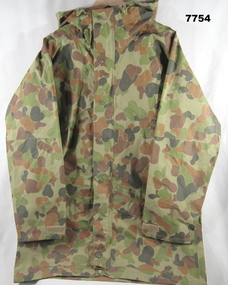 Bendigo Military Museum
Uniform - JACKET, WORK DRESS - ARMY, Australian Defence Industries, 2008
DCPU (Disruptive Pattern Camouflage Uniform) Work dress jacket - Colours light to dark green through to light to dark brown. Gore-Tex fabric for wet weather. Hood with peak and elastic drawstring with plastic lock clip. Plastic/metal two ended zipper and metal press studs - front fastening. Two front pockets with loop and hook (Velcro) fasteners. Two interior nylon mesh pocket with zipper. Sleeves at wrist - loop and hook adjustable strap. White colour polyester fabric manufacturers label on front zipper. Manufacturers information on label - black ink print. Label 1 "GSSM/www.gssm.com.au/MAR 2008/O/N 248007/ N/S/N 8415 - 66 - 145- 7093/ SIZE:L/ CHEST: 100-110CM /NAME/SERVICE" "CARE INSTRUCTIONS/ MACHINE WASHABLE: 40c/ DO NOT BLEACH/ DO NOT SPIN DRY/ DO NOT WRING/HAND TO DRY/ LIGHT/ COOL IRON/ FABRIC CONTENT/ FACE/LINER: 100% POLYESTER/ LAMINATE: PTFE" Label 2. "BATCH NO./5301011". uniform, army, work dress, dpcu -
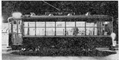 Ballarat Tramway Museum
Newspaper, Herald & Weekly Times Ltd, "A Place in the Sun", "Save the Trams", 1971
Set of two Newspaper clippings pasted onto a single sheet of paper with two Punch holes on the left hand side. Clipping from The Courier, Ballarat, 19/8/1971; two letters to the Editor, about the closure of the Ballarat tramways, that some of the trams and line should be saved and what the aims of the BTPS are. The first from a person titled "All Het Up", and the second from John Anderson of P.O. Box 145 Box Hill. The second clipping from The Sun, Melbourne dated 14/7/1971 written by Keith Dunstan in his column, "A Place in the Sun" about the forthcoming closure of the Ballarat and Bendigo systems. Has a photo of a Bendigo Birney tram and notes their rarity. The second part is about the formation of the BTPS, which has 100 paid up members and quotes Shane McCarthy, a committeeman. Both cuttings in two portions.In red ink in lower edge of first cutting "19/8/71". On sheet of paper, various pencil / ink markings - with date Dec. 1963. Possibly paper used by Donor at his job with the former machinery makers, Ronaldson and Tippet.trams, tramways, closure, btps, birney, preservation -
 Eltham District Historical Society Inc
Photograph - Aerial Photograph, Landata, Eltham, Vic, Jan. 1951
Centred on Allison Crecent Reserve, Sherbrook Road and Scenic Crescent, Eltham bounded by Allendale Road to north, Dudley Street to south, Zig Zag Road to east and St Helena Road to west. Historic Aerial Imagery Source: Landata.vic.gov.au Aerial Photo Details: Project No :65 Project : MELBOURNE AND METROPOLITAN PROJECT NO. 2 Run : 7 Frame : 10 Date : 01/1951 Film Type : B/W Camera : EAG9 Flying Height : 12200 Scale : 12000 Film Number : 1419 GDA2020 : 37°42'14"S, 145°08'36"E MGA2020 : 336339, 5825416 (55) Melways : 21 H2 (ed. 42)Historical aerial photos and photo maps provide viusal evidence of the chronology of changes to the built landscape of the district and assist in dating other imagesaerial photo, 1951-01, eltham, neil webster collection, allendale road, allison crecent reserve, dudley street, melway 21h2, scenic crescent, sherbrook road, st helena road, zig zag road -
 Eltham District Historical Society Inc
Photograph - Aerial Photograph, Landata, Montmorency, Feb. 1956
Centred on present day Grand Boulevard and Olympic Way, Montmorency bounded by Diamond Street to north, Old Eltham Road and Eltham Lower Park to south, Bible Street to east and Para Road to west. Historic Aerial Imagery Source: Landata.vic.gov.au Aerial Photo Details: Project No :250 Project : MELBOURNE OUTER SUBURBS PROJECT Run : 17 Frame : 115 Date : 02/1956 Film Type : B/W Camera : EAG9 Flying Height : 10000 Scale : 12000 Film Number : 1176 GDA2020 : 37°43'24"S, 145°07'55"E MGA2020 : 335375, 5823236 (55) Melways : 21 F7 (ed. 42)aerial photo, 1956-02, neil webster collection, eltham, main road, montmorency, bible street, diamond street, eltham lower park, grand boulevard, melway 21f7, old eltham road, olympic way, para road -
 Eltham District Historical Society Inc
Photograph - Aerial Photograph, Landata, Eltham, Feb. 1956
Centred on present day Mount Plaeasant Road near Dalton Street, Eltham bounded by Luck Street to north, Eltham Lower Park to south, Reynolds Road to east and Central Park to west Historic Aerial Imagery Source: Landata.vic.gov.au Aerial Photo Details: Project No :250 Project : MELBOURNE OUTER SUBURBS PROJECT Run : 18 Frame : 93 Date : 02/1956 Film Type : B/W Camera : EAG9 Flying Height : 10000 Scale : 12000 Film Number : 1176 GDA2020 : 37°43'02"S, 145°09'38"E MGA2020 : 337871, 5823961 (55) Melways : 22 B6 (ed. 42)aerial photo, 1956-02, neil webster collection, eltham, central park, eltham lower park, luck street, melway 22b6, nyora road, reynolds road, dalton street, mount pleasant road -
 Eltham District Historical Society Inc
Photograph - Aerial Photograph, Landata, Eltham, Vic, Feb. 1956
Centred on present day Parsons Avenue at Leane Drive near the Maroondah Aqueduct, Eltham bounded by Lorimer Road to north, Thompson Crescent and Norman Road to south, Bells Hill Road to east and Parsons Road to west Historic Aerial Imagery Source: Landata.vic.gov.au Aerial Photo Details: Project No :250 Project : MELBOURNE OUTER SUBURBS PROJECT Run : 19 Frame : 5 Date : 02/1956 Film Type : B/W Camera : EAG9 Flying Height : 10000 Scale : 12000 Film Number : 1176 GDA2020 : 37°42'04"S, 145°11'09"E MGA2020 : 340064, 5825786 (55) Melways : 22 H1 (ed. 42)aerial photo, 1956-02, neil webster collection, allendale road, bells hill road, eltham, leane drive, lorimer road, maroondah aqueduct, melway 22h1, norman road, parsons road, research (vic.), thompson crescent -
 Eltham District Historical Society Inc
Photograph - Aerial Photograph, Landata, Eltham, Vic, Apr. 1963
Centred on present day Zig Zag Road and Main Road, Eltham bounded by Maroondah Aqueduct to north, Thompson Crescent and Arthur Street to south, Parsons Road to east and Glen Park Road and Banks Road to west. Historic Aerial Imagery Source: Landata.vic.gov.au Aerial Photo Details: Project No :486 Project : MELBOURNE (1963) PROJECT Run : 5 Frame : 59 Date : 04/1963 Film Type : B/W Camera : RC8 Flying Height : 5100 Scale : 9600 Film Number : 1805 GDA2020 : 37°42'24"S, 145°08'52"E MGA2020 : 336716, 5825114 (55) Melways : 21 J3 (ed. 42)aerial photo, neil webster collection, eltham, 1963-04, arthur street, banks road, glen park road, maroondah aqueduct, melway 21j3, parsons road -
 Eltham District Historical Society Inc
Photograph - Aerial Photograph, Landata, Eltham, Vic, Apr. 1963
Centred on present day Floriston Grove, Eltham bounded by Maroondah Aqueduct to north, Thompson Crescent and Diosma Road to south, Research Shops to east and Glen Park Road and Park West Road to west. Historic Aerial Imagery Source: Landata.vic.gov.au Aerial Photo Details: Project No :486 Project : MELBOURNE (1963) PROJECT Run : 5 Frame : 60 Date : 04/1963 Film Type : B/W Camera : RC8 Flying Height : 5100 Scale : 9600 Film Number : 1805 GDA2020 : 37°42'24"S, 145°09'29"E MGA2020 : 337622, 5825128 (55) Melways : 22 B3 (ed. 42)aerial photo, neil webster collection, eltham, 1963-04, diosma road, floriston grove, maroondah aqueduct, melway 22b3, park west road, research (vic.), research shops -
 Eltham District Historical Society Inc
Photograph - Aerial Photograph, Landata, Lower Plenty, Vic, Apr. 1963
Centred on present day Old Eltham Road near Araluen Centre, Lower Plenty bounded by Cromwell Street to north, Yarra River to south, Main Road at Mount Pleasant Road to east and Panorama Avenue to west. Historic Aerial Imagery Source: Landata.vic.gov.au Aerial Photo Details: Project No :486 Project : MELBOURNE (1963) PROJECT Run : 7 Frame : 231 Date : 04/1963 Film Type : B/W Camera : RC8 Flying Height : 5100 Scale : 9600 Film Number : 1805 GDA2020 : 37°44'03"S, 145°07'56"E MGA2020 : 335420, 5822027 (55) Melways : 21 F10 (ed. 42)aerial photo, neil webster collection, 1963-04, araluen, cromwell street, eltham, lower plenty, main road, melway 21f10, mount pleasant road, old eltham road, panorama avenue, yarra river -
 Eltham District Historical Society Inc
Photograph - Aerial Photograph, Landata, Eltham, Vic, Apr. 1963
Centred on present day Eltham Lower Park bounded by Brougham Street to north, Yarra River and Fitzsimons Lane Bridge to south, Main Road at Kent Hughes Road to east and Bolton Street to west. Historic Aerial Imagery Source: Landata.vic.gov.au Aerial Photo Details: Project No :486 Project : MELBOURNE (1963) PROJECT Run : 7 Frame : 232 Date : 04/1963 Film Type : B/W Camera : RC8 Flying Height : 5100 Scale : 9600 Film Number : 1805 GDA2020 : 37°44'03"S, 145°08'33"E MGA2020 : 336329, 5822040 (55) Melways : 21 H10 (ed. 42)aerial photo, neil webster collection, 1963-04, bolton steet, brougham steet, eltham, eltham lower park, fitzsimons lane bridge, kent hughes road, melway 21h10, yarra river -
 Eltham District Historical Society Inc
Photograph - Aerial Photograph, Landata, Eltham North, Vic, Apr. 1972
Centred on present day Eltham North reserve near Eltham North Primary School, Eltham North bounded by Allendale Road to north, Bellevue Road to south, Zig Zag Road and Beard Street to east and Ryans Road to west. Historic Aerial Imagery Source: Landata.vic.gov.au Aerial Photo Details: Project No :985 Project : MELBOURNE 1972 Run : 26 Frame : 190 Date : 04/1972 Film Type : B/W Camera : RC10 Flying Height : 5700 Scale : 9600 Film Number : 2636 GDA2020 : 37°41'52"S, 145°08'52"E MGA2020 : 336705, 5826102 (55) Melways : 11 J12 (ed. 42)aerial photo, neil webster collection, 1972-04, allendale road, beard street, bellevue road, eltham, eltham north, eltham north reserve, melway 11j12, ryans road, zig zag road, eltham north primary school -
 Eltham District Historical Society Inc
Photograph - Aerial Photograph, Landata, Research, Vic, Apr. 1972
Centred on present day Main Road, Research near Maroondah Aqueduct and Eltham College bounded by Allendale Road to north, Research-Warrandyte Road to south, Swipers Gully Training Restaurant to east and Reynolds Road to west. Historic Aerial Imagery Source: Landata.vic.gov.au Aerial Photo Details: Project No :985 Project : MELBOURNE 1972 Run : 26 Frame : 194 Date : 04/1972 Film Type : B/W Camera : RC10 Flying Height : 5700 Scale : 9600 Film Number : 2636 GDA2020 : 37°42'07"S, 145°11'07"E MGA2020 : 340015, 5825692 (55) Melways : 22 H1 (ed. 42)aerial photo, neil webster collection, 1972-04, allendale road, eltham college, main road, maroondah aqueduct, melway 22h1, research (vic.), research-warrandyte road, reynolds road, swiper's gully -
 Eltham District Historical Society Inc
Photograph - Aerial Photograph, Landata, Eltham, Vic, Apr. 1972
Centred on present day Diamond Creek Trail at the Eltham Leisure Centre bounded by Central Park to north, Main Road at Falkiner Street to south, MacMahon Ball Paddock to east and Grand Boulevard at Buena Vista Drive to west. Historic Aerial Imagery Source: Landata.vic.gov.au Aerial Photo Details: Project No :985 Project : MELBOURNE 1972 Run : 28 Frame : 207 Date : 04/1972 Film Type : B/W Camera : RC10 Flying Height : 5700 Scale : 9600 Film Number : 2635 GDA2020 : 37°43'25"S, 145°08'20"E MGA2020 : 335985, 5823223 (55) Melways : 21 G7 (ed. 42)aerial photo, neil webster collection, 1972-04, eltham, buena vista drive, central park, diamond creek trail, eltham leisure centre, falkiner street, grand boulevard, macmahon ball paddock, main road, melway 21g7 -
 Eltham District Historical Society Inc
Photograph - Aerial Photograph, Landata, Eltham, Main Road; Mt Pleasant Rd to Railway Rd, Dec. 1945
Centred on Main Rd and Henry St, Eltham bounded by Railway Road to north, Mount Pleasant Road at Main Road to south, top of the hill in Arthur Street to east and Karingal Drive at Sherbourne Road to west. Historic Aerial Imagery Source: Landata.vic.gov.au Aerial Photo Details: Project No :65 Project : MELBOURNE AND METROPOLITAN PROJECT NO. 2 Run : 8 Frame : 70 Date : 01/1951 Film Type : B/W Camera : EAG9 Flying Height : 12200 Scale : 12000 Film Number : 1419 GDA2020 : 37°43'06"S, 145°08'45"E MGA2020 : 336589, 5823811 (55) Melways : 21 J6 (ed. 42)aerial photo, eltham, main road, henry street, arthur street, bolton street, eltham-yarra glen road, neil webster collection, 1951-01, dave lyon house, ernie andrew house, karingal road, melway 21j6, mount pleasant road, railway road -
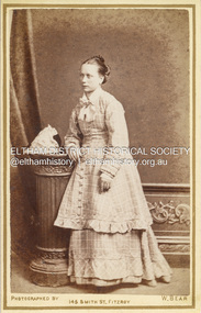
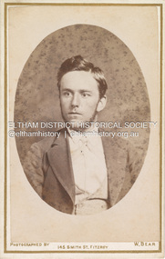 Eltham District Historical Society Inc
Photograph, W. Bear, Possibly Sarah Ann Shillinglaw’s brother, William Kidd (1853-1901), c.1880
William Bear, Photographer operated from 145 Smith Street, Fitzroy from 1877 to 1882. Prior to that the address was occupied by F.C. Burman to 1876 and followed by W. Latimer in 1883 (Sands Melbourne Directory) Marg Ball suggested the fellow may possibly be a Kidd. Put side by side with Sarah Ann Shillinglaw (nee Kidd) and he certainly could be a brother. Looking at Sarah and her siblings, 2nd eldest William seems the most/only candidate given the date of the photo. William Bear only operated from 145 Smith St., Fitzroy from 1877 through 1882. The fashion/hair/whiskers suggest it is moving out of the 1870s and into the 1880s so it is fairly reasonable to suggest circa 1880 for the photo. At that time, William would be 27 – looks right. The only other two brothers, Samuel and Matthew had both died as youngsters years earlier. Further, the placement of the photo in the album on the opposite page to the only photo of Sarah suggests there is a close relationship. CARTE-DE-VISITE (cdv) 1857-1890 Cartes-de-visite (cdv's) are the most common form of photograph from the nineteenth century, generally measuring two and a half inches by four and an eighth inches (6.3 x 10.5 cm) when mounted, sepia toned, mounted on a card which was generally printed with the photographer's name and address on the back or beneath the portrait. - Frost, Lenore; Dating Family Photos 1850-1920; Valiant Press Pty. Ltd., Berwick, Victoria 1991marg ball collection, shillinglaw family photo album 1, 1877-1882, 1880, w. bear photographer 145 smith st fitzroy, william kidd (1853-1901) -
 Eltham District Historical Society Inc
Photograph - Aerial Photograph, Landata, Eltham, Feb. 1956
Centred on present day Culla Hill and Petty's Orchard, Eltham bounded by Brougham Street and Mount Pleasant Road to north, Monckton Road, Templestowe to south, Reynolds Road to east and Eltham Lower Park and Hohnes Road to west. Historic Aerial Imagery Source: Landata.vic.gov.au Aerial Photo Details: Project No :250 Project : MELBOURNE OUTER SUBURBS PROJECT Run : 18 Frame : 92 Date : 02/1956 Film Type : B/W Camera : EAG9 Flying Height : 10000 Scale : 12000 Film Number : 1176 GDA2020 : 37°43'35"S, 145°09'31"E MGA2020 : 337735, 5822959 (55) Melways : 22 B8 (ed. 42)aerial photo, 1956-02, neil webster collection, eltham, brougham steet, culla hill, eltham lower park, hohnes road, melway 22b8, monckton road, mount pleasant road, petty's orchard, reynolds road, sweeneys lane, templestowe, yarra river -
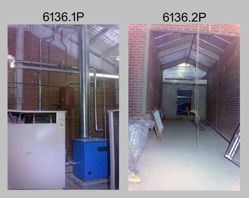
 Bendigo Military Museum
Photograph - New Printing Building foundation preparation, Lithographic Squadron - Army Survey Regiment, Fortuna, Bendigo, 1987
This is a set of 18 photographs of contractors preparing the foundations for the construction of Lithographic Squadron’s new Printing Building at Fortuna, Bendigo on the 2nd of October 1987. The building was purpose built to house a new computer-controlled Heidelberg Speedmaster 102 five colour lithographic offset Printing Press. The print room was named Wayzgoose Hall after a medieval printing house festival. Wayzgoose Hall and the Speedmaster Press printing capability was commissioned by the Commander of the 3rd Military District BRIG P. Davies AM, ADC on Wednesday 27th June 1990. This occasion is covered in more detail in page 145 of Valerie Lovejoy’s book 'Mapmakers of Fortuna – A history of the Army Survey Regiment’ ISBN: 0-646-42120-4.This is a set of 18 photograph of the foundations being prepared for Lithographic Squadron’s new Printing Building, Army Survey Regiment at Fortuna, Bendigo, 2nd October 1987. Black and white photos .1P to .4P are on photographic paper and scanned at 300 dpi. Photographs .5P to.18P are on 35mm negative film and scanned at 96 dpi. They are part of the Army Survey Regiment’s Collection. .1) to .9) - Photo, black & white, 1987. Foundations preparation. .10) - Photo, black & white, 1987. Foundations preparation, Paul Baker. .11) - Photo, black & white, 1987. Foundations preparation, Gary Kerr .12) to .17) - Photo, black & white, 1987. Foundations preparation. .18) - Photo, black & white, 1987. Foundations preparation, Gary Kerr No personnel are identified. Annotated with date on negative sleeve.royal australian survey corps, rasvy, army survey regiment, army svy regt, fortuna, asr, litho, printing -
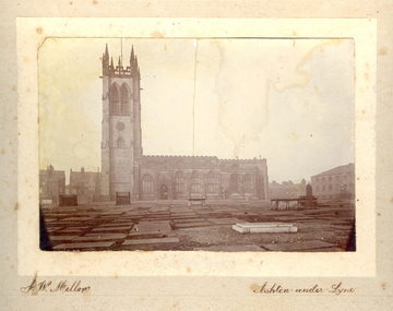 Federation University Historical Collection
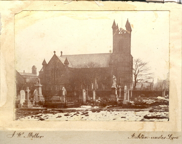
Photograph - Photo, J.W. Mellor, St Michael's and All Angels church and cemetery, Ashton-under-Lyne
The Church of St Michael and All Angels dates from the 15th century and is the Parish Church for Ashton under Lyne. It is believed there was a church on this site before the Norman Conquest as the Domesday Book mentions a St Michael's Church in the east of the ancient parish of Manchester. Much of the structure was re-constructed in Victorian times. The church with large windows in Perpendicular style. Buttresses were required with this type of building as the large window area reduced the strength of the walls. The church boasts boasts some of the best examples of fifteenth century stained glass left in Britain. There are eighteen panels illustrating the life of St. Helena. The church tower is 145 feet high and has a peel of thirteen bells. (From ashton-under-lyne.com) .1) Sepia photograph mounted onto card showing St Michael's and all Angels church and graveyard in Ashton-Under-Lyne. The gravestones shown in the photograph are no longer evident today. The cemetery area is now covered with grass.cemetery, st michael s and all angels, ashton under lyne, j w mellor, church -
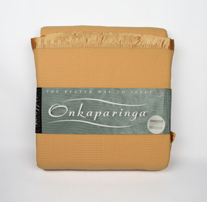 National Wool Museum
Textile - Onkaparinga Blanket, Waffle Collection, Unknown
Onkaparinga started in South Australia in 1869. Migrating from Germany, two brothers, Heinrich and Edward Kramm, both weavers, purchased and brought with them some machinery and established themselves in Hahndorf in a mud hut. Their original plant consisted of one carding machine, one spinning mule of 30 spools and 2 hand looms. The spinning mule was horse driven, the others all hand operated. The wool was washed by hand and dried in the sun then teased by hand. Now 145 years later the brand name Onkaparinga, is known all over the world, the products reflect the experience, passion and ingenuity of over a century's tradition in providing luxurious home wares. Donated to the National Wool Museum by Joyce GrayLight orange waffle weave woolen blanket, with nylon trimming. Product tag included with plastic case. On product tag - The better way to sleep. Onkaparinga onkaparinga, blanket, wool, kramm -
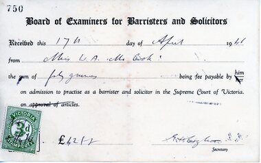 Ringwood and District Historical Society
Memorabilia, Winifred McCook, Barrister and Solicitor, Ringwood, Victoria
Miscellaneous papers/ephemera from the office of Miss McCook, the first and only female Solicitor in Ringwood for many years, practicing from her office at 173 Whitehorse Road until her retirement. 5525A. Receipt for payment of £42 (forty guineas) payable on admission to practice as a barrister and solicitor in the Supreme Court of Victorias, dated 17th April, 1946. 5525B. Wages return, financial year ending 30th June, 1954, £1470-8-0. 5525C. Invoice and receipt for dental work Dr to David M. Lush, 145 Whitehorse Road, Ringwood, 15-9-1967, $110. 5525D. Stationery - envelope and letter head from pracice of Winifred McCook, LL.B., Barrister and Solicitor, 173 Whitehorse Road, Ringwood, 3134, Telephones 8708532 8703834. 5525E. State Bank Term Deposit Receipt to Miss Winifred A. McCook, 87 Dorking Road, Box Hill 3128, maturing 15/2/1982, $1400. -
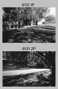
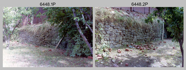 Bendigo Military Museum
Photograph - New Printing Building Construction, Lithographic Squadron - Army Survey Regiment, Fortuna, Bendigo, c1989
This is a set of 12 photographs of contractors constructing Lithographic Squadron’s new Printing Building at Fortuna, Bendigo circa 1989. The building was purpose built to house a new computer-controlled Heidelberg Speedmaster five colour lithographic offset Printing Press. The print room was named Wayzgoose Hall after a medieval printing house festival. Wayzgoose Hall and the Speedmaster Press printing capability was commissioned by the Commander of the 3rd Military District BRIG P. Davies AM, ADC on Wednesday 27th June 1990. This occasion is covered in more detail in page 145 of Valerie Lovejoy’s book 'Mapmakers of Fortuna – A history of the Army Survey Regiment’ ISBN: 0-646-42120-4. See items 6131.18P and 6444.16P for photos of earlier phases of the construction process.This is a set of 12 photograph of the construction of Lithographic Squadron’s new Printing Building, Army Survey Regiment at Fortuna, Bendigo, c1989. Colour photographs are on 35mm negative film and scanned at 96 dpi. They are part of the Army Survey Regiment’s Collection. .1) to .2) - Photo, colour, 1989. Old stone retaining wall .3) to .12) - Photo, colour, 1989. Construction of new printing building.No personnel are identified. royal australian survey corps, rasvy, army survey regiment, army svy regt, fortuna, asr, litho sqn, printing -
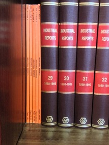 RMIT GSBL Justice Smith Collection
Journal series, The Law Book Company Limited, Industrial Arbitration Service : industrial reports, 1986
Previous owners: Phillips Fox"The Industrial Reports are Australia’s only specialist full-text case report series on industrial and employment law. The Industrial Reports are the authorised reports of Fair Work Australia and the Industrial Relations Commission of NSW. The series also provides relevant decisions of the High Court, Federal Court, State and Territory Supreme Courts, and Federal and State Industrial Courts and Tribunals. Each reported case includes a detailed headnote highlighting the key issues and decision in the case. The Industrial Reports online archive begins from Volume 1 and includes PDF versions of the cases. The series is integrated with other Westlaw AU services including FirstPoint (subject to separate subscription), allowing users to quickly check the history and current status of every reported decision." from: http://www.thomsonreuters.com.au/industrial-reports-parts-only/productdetail/19996 No. of volumes: 157 Volume range: Vol. 9 parts 1-5 (1985) (unbound), Vol. 29 (1988-1989) - Vol. 168 (2007) (bound), Vol. 169 parts 1-4 (2008) (unbound), Vol. 170 parts 1-2 (2008) (unbound), Index Vol. 1-40 (1981-1992) (bound), Index Vol. 41-80 (1991-1998) (bound), Index 81-105 (1999-2001) (bound), Consolidated index Vol. 126-145 (2003-2005) (unbound), Consolidated index Vol. 126-150 (2003-2006) (bound) + Consolidated index Vol. 151-165 (2006-2007) (unbound) Missing volumes: Vol. 10-28, Index 106-125 Note: Vol. 140 is an Anthology covering 1990-2003 Editors: Hungerford, B. C. (Vol. 9) Peterson, R. J. (Vol. 9) Wright, F. L. (Vol. 9 - 81) Thomson, A. (Vol. 82 - 170 part 2) Anthology editor: Phillips, J. ISSN: 07288417arbitration; industrial -- australia -- law and legislation -
 Eltham District Historical Society Inc
Photograph, W. Bear, Possibly Catherine Shillinglaw, c.1880
Catherine Shillinglaw was born November 13, 1852 at Coburg, Victoria. In 1897 she married Edward Henry Bottle (1854-1900). Catherine died April 7, 1934 at Northcote, Victoria. According to Sands & McDougall Melbourne Directory, W. Bear was active at 145 Smith Street, Fitzroy from 1877 to 1882 CARTE-DE-VISITE (cdv) 1857-1890 Cartes-de-visite (cdv's) are the most common form of photograph from the nineteenth century, generally measuring two and a half inches by four and an eighth inches (6.3 x 10.5 cm) when mounted, sepia toned, mounted on a card which was generally printed with the photographer's name and address on the back or beneath the portrait. - Frost, Lenore; Dating Family Photos 1850-1920; Valiant Press Pty. Ltd., Berwick, Victoria 1991marg ball collection, shillinglaw family photo album 1, 1877-1882, 1880, catherine bottle (nee shillinglaw 1852-1934), unknown, w. bear photographer 145 smith st fitzroy -
 Bendigo Military Museum
Photograph - New Printing Press, Lithographic Squadron – Army Survey Regiment, Fortuna, Bendigo, 1990
This is a set of 30 photographs of contractors installing the Army Survey Regiment’s new Heidelberg Speedmaster 102 printing press in Lithographic Squadron’s purpose-built printing building at Fortuna, Bendigo in 1990. The computer-controlled five colour lithographic offset printing press provided the Royal Australian Survey Corps vastly improved printing capability, as the five colours for a standard topographic map was printed in a single pass. The print room was named Wayzgoose Hall after a medieval printing house festival. Wayzgoose Hall and the Speedmaster printing capability was commissioned by the Commander of the 3rd Military District BRIG P. Davies AM, ADC on Wednesday 27th June 1990. This occasion is covered in more detail in page 145 of Valerie Lovejoy’s book 'Mapmakers of Fortuna – A history of the Army Survey Regiment’ ISBN: 0-646-42120-4.This is a set of 30 photograph of the Heidelberg Speedmaster 102 Printing Press installation in Lithographic Squadron, Army Survey Regiment at Fortuna, Bendigo, 1990. The photographs were on 35mm colour negative film and were scanned at 96 dpi. They are part of the Army Survey Regiment’s Collection. No personnel are identified. Annotated with date on negative sleeve.royal australian survey corps, rasvy, army survey regiment, army svy regt, fortuna, asr, litho, printing -
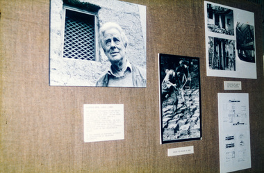 Eltham District Historical Society Inc
Photograph, Peter Bassett-Smith, Alistair Knox collection, 1988
Wall display of photographs and cabinets of books as part of the Bicentennial/Heritage Week Display, "The Eltham Tradition", held in the Eltham Shire Office, 17-22 April 1988 by EDHS. The Alistair Knox Collection is a series of mounted enlarged photos of about forty images mud brick houses and related subjects. The collection is understood to have been put together by Alistair Knox although it is the work of several unacknowledged photographers. For some years it was held by the Building Department of the former Eltham Shire Council and was then passed to EDHS. Some of the photos have been used in Knox's books. Alistair Knox (1912 - 1986) is acknowledged as the founder of Eltham's mud brick building movement. Many of the buildings shown in the collection are of his design and he was also involved with the construction of several of them. Others are the work of his contemporaries and associates such as Peter Glass, Gordon Ford, and John Harcourt. (EDHS Newsletter No. 145 July 2002) Two colour photographsactivities, eltham shire office, heritage display, heritage week, alistair knox -
 Eltham District Historical Society Inc
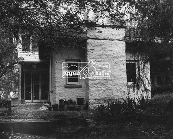
Photograph, Tim and Betty Burstall House (1948-1960s)
Tim and Betty Burstall designed and built their mud brick house in (68 Napier Crescent) Montmorency in 1948. Extensions were added in the 1960s. The Alistair Knox Collection (Image 6) The Alistair Knox Collection is a series of mounted enlarged photos of about forty images mud brick houses and related subjects. The collection is understood to have been put together by Alistair Knox although it is the work of several unacknowledged photographers. For some years it was held by the Building Department of the former Eltham Shire Council and was then passed to EDHS. Some of the photos have been used in Knox's books. Alistair Knox (1912 - 1986) is acknowledged as the founder of Eltham's mud brick building movement. Many of the buildings shown in the collection are of his design and he was also involved with the construction of several of them. Others are the work of his contemporaries and associates such as Peter Glass, Gordon Ford, and John Harcourt. (EDHS Newsletter No. 145 July 2002)Handwritten notes in pencil re details of building, year of construction, owner, designer, builder, etcbetty burstall, houses, mud brick construction, tim and betty burstall house, tim burstall, montmorency, alistair knox collection -
 Melbourne Tram Museum
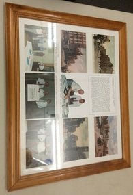
Photograph - Framed Photographs, Department of Transport, "Presentation of an Essay to the Department of Transport Victoria, March 1994", Mar. 1994
Set of 9 postcard, document or images framed with a wooden frame at the time of the "Presentation of an Essay to the Department of Transport Victoria, March 1994". Has a white backing for postcards and photos, approx. 145 x 100. Items have been placed it appears on an under backing. Glazed, craftwood backing secured with staples into the frame. On the rear has a printed label with a red border on white paper with the number "27" in black. From Top left to bottom right: , Postcard of Swanston St with St Pauls, Note about the presentation and the work undertaken by Jack Cranston, Postcard of Queens Bridge Melbourne, looking north from the south side of the Yarra, Postcard of Flinders St, Photo of Jack Cranston with Minister for Transport, Alan Brown MP, Postcard of Collins St Melbourne, Photo of presentation party - Jack Cranston, Con O'Carroll, Robert Wilson, Graham Jones, Robert Green, John Keating and Alan Brown., Photo of Alan Brown, Jack Cranston and Kim Wells holding the Plans and Sections folder (see Reg Item 583)., Photo of Alan Brown and Jack Cranston.trams, tramways, cable trams, horse trams, mto co, melbourne -
 Federation University Historical Collection
Photo, J.W. Mellor, Holy Trinity, Bardsley and St Michael's and All Angels Church and Cemetery, Ashton-under-Lyne
The Church of St Michael and All Angels dates from the 15th century and is the Parish Church for Ashton under Lyne. It is believed there was a church on this site before the Norman Conquest as the Domesday Book mentions a St Michael's Church in the east of the ancient parish of Manchester. Much of the structure was re-constructed in Victorian times. The church with large windows in Perpendicular style. Buttresses were required with this type of building as the large window area reduced the strength of the walls. The church boasts boasts some of the best examples of fifteenth century stained glass left in Britain. There are eighteen panels illustrating the life of St. Helena. The church tower is 145 feet high and has a peel of thirteen bells. (From ashton-under-lyne.com) Holy Trinity Church, Bardsley was consecrated on the 10th October 1844 by the Bishop of Chester. The church was only the third church in the Borough of Ashton-under-Lyne to be carved out of the parish of St. Michael & All Angels, Ashton. The church was built on land donated by the Hulme Trustees..1) Sepia photograph mounted onto card showing Holy Trinity, Bardsley, Ashton-under-Lyne. Snow is evident in the foreground and the church is surrounded by a graveyard. .2) Sepia photograph mounted onto card showing St Michael's and All Angels church, alongside a graveyard.Signed lower LHS "J.W. Mellor" Lower RHS "Ashton-under-Lyne"cemetery, st michael s and all angels, ashton under lyne, j w mellor, tombstone, tomb stone, headstone, head stone, holy trinity church, bardsley