Showing 15878 items
matching areas
-
 Mt Dandenong & District Historical Society Inc.
Photograph
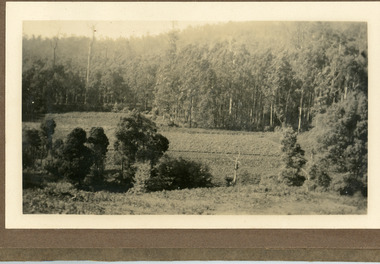
The photograph is from the album of Ivy Child and shows a shows an area of Kalorama that has been cleared to grow crops. Ivy May Child (1910 – 1989) was the daughter of Arthur Edward (Ted) Child (1878 – 1964) and Ethel May Madden (1888 – 1970). Ted Child was the son of Matthew Francis Child (1839 – 1933) and Martha Jeeves (1857 – 1926). He was the grandson of one of the early pioneers Francis Child. Ivy grew up on the family property on Childs Road and took many photographs. Most of these are glued into her photo album. The album covered the years from c1927 – 1932. Ivy married Henry William Burgess (1906 – 1968) in 1944. The photographs remain in their original state in the album with individual copies made. Black and white photograph with bushes in the foreground, a cleared area in the centre and thick trees behind.ivy child, kalorama, crops -
 Hume City Civic Collection
Photograph
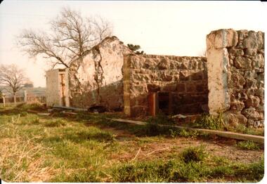
This is a photograph of one of the many stone ruins of buildings which can be seen in the Sunbury district and surrounding areas. This series of 13 photographs show various views of one of the remaining uninhabited stone cottages which were built in the early days of the district's settlement.A coloured photograph of the ruins of a stone cottage. The walls are still standing and the end wall bears evidence of the original pitched roof. There is a cleared area in front of the ruins.stone structures, shingle roofs, george evans collection -
 Whitehorse Historical Society Inc.
Document, Notes on Job. Hone, n.d
Notes on Job Hone's arrival in Victoria in 1850.Notes on Job Hone's arrival in Victoria in 1850, one of the first people to discover gold at Avoca, returned to Box Hill in 1853 and bought land. he assisted in establishing most of the churches in the area.Notes on Job Hone's arrival in Victoria in 1850. hone, job, pioneers -
 Federation University Historical Collection
Set of black and white photographs - Athletics sports, Ballarat Junior Technical School Sports Day
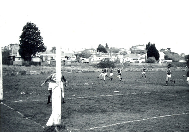
Ballarat Junior Technical School moved to the new building in 1921. The grounds were cleared, terraced and planted out. Another area below the terraces was known aas White Flat. This was cleared and became the oval for the school allowing for all sporting activities to be carried out.Set of photographs showing sports day, Ballarat Junior Technical School. Area used is White Flat Oval which was completed as a playing ground in 1925 -
Ringwood and District Historical Society
Envelope, Packet: Ringwood Art Society; Aldred's Junction Store; Artists 1953-1970's
Artists of the area. -
Ringwood and District Historical Society
Leaflet, City of Ringwood, Ringwood News pamphlet 2 Feb 1991, 2-Feb-91
Issued to inform residents of the district and changes in the area. Subjects include the Ringwood Festival Programmeand the proposed Ringwood District centre.Pamphlet 'Ringwood News' issued to inform residents of the district and changes in the area. Subjects include the Ringwood Festival Programme and the proposed Ringwood District centre.; Issue No. 2 dated 2-Feb-1991 pp. 8.City of Ringwood News -
 Federation University Historical Collection
Photograph - Black and white photograph, Ballarat Junior Technical School - outside the Gaol wall - 1921, c1921
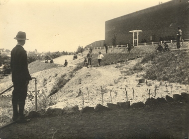
In February 1913 the Ballarat Junior Technical School opened its doors to its 86 pupils. The old bluestone building in the grounds of the Dana Street Primary School became their temporary home for eight years. In its early years the school offered only a two-year course. The first year was of a general nature giving a thorough grounding in Mathematics and Instrumental Drawing, and introducing students to the various branches of trade work. The second-year students studied for the Junior Technical Certificate and specialized in a course of their choice - either a trade (Woodwork or Fitting and Turning) or a course leading to higher studies at the School of Mines. Increased enrolments - 86 to 110 in the second year. Some applicants were turned away due to lack of space. An abandoned single room school was brought in and this helped for a time. Plans were developed and a two-storied red brick building in the vacinity of the School of Mines was build. An acre of land was reclaimed from the north-east corner of the Ballarat Gaol. The school backed onto the wall of the gaol. The task of landscaping and terracing of the area was to cost a great deal and time. The boys did much of the heavy work. This kept them occupied as the official playground areas were still full of rubble. This photograph shows the work that has been done in terracing and landscaping the area.Junior Technical School with the slope from the gaol wall down to the area known as the Battery Paddock. New plantings and rock edging evident in the foreground.junior technical school, dana street primary school, bluestone, mathematics, instrumental drawing, junior technical certificate, woodwork, fitting and turning, school of mines, ballarat gaol, landscaping, terracing, gaol wall -
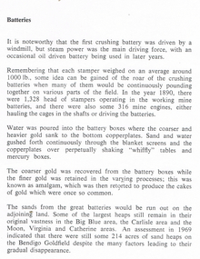 Bendigo Historical Society Inc.
Document - LONG GULLY HISTORY GROUP COLLECTION: BATTERIES
Printed notes titled Batteries. Mentions crushing batteries and stampers, how the gold was extracted and how gold was recovered. Disposal of the sand is also mentioned and the great areas of sand dumps around the mines. Some sand areas mentioned are the Bih Blue area, Carlisle area and the Moon, Virginia and Catherine areas.bendigo, history, long gully history group, the long gully history group - batteries, crushing battery, windmill, whiffly tables, big blue area, carlisle area, moon area, virginia area, catherine area, bendigo goldfield -
Glenelg Shire Council Cultural Collection
Map - Map - Bridgewater Lakes Tour, 1970s
Typed up directions around the Bridgewater area. Inside: Map of Portland - Bridgewater area.map, tourism, travel, recreation, cape bridgewater -
 Clunes Museum
Photograph
LANDS DEPARTMENT COLOURED PHOTOGRAPH - CLEARING AREA ALONG CREEK TO MAKE PICNIC AREAlocal history, photography, photographs, clunes landscape -
 Whitehorse Historical Society Inc.
Photograph, Yarran Dheran - BBQ, c 1985
Black and white photograph of the BBQ area and swing at the Yarran Dheran picnic area in 1985yarran dheran, barbecues -
 Halls Gap & Grampians Historical Society
Photograph - B/W
This is a photo of the Halls Gap Recreation area. The building is possibly the change shed for the swimming pool.The photo is a distance shot of a tall narrow building with a pitched roof and small windows high up along the side. There is a metal set of swings/ladder and a lower set of metal equipment near the building. It stands in a cleared area surrounded by bush. recreation, sport -
 Latrobe Regional Gallery
Print, ROBINSON, Brian. Born 1973, Waiben, Queensland, Australia, Goi Goi, 2011
Linocut print on paper. Printer's Proof.'P/P' under bottom left of printed area, 'GOI GOI' centred under printed section, signed on bottom right edge of print area. linocut, pattern, cultural reference -
Whitehorse Historical Society Inc.
Article, Live like a legend, 19/05/1999 12:00:00 AM
Article in the 'Age' advertising a house for sale in Blackburn.Article in the 'Age' advertising a house for sale in Blackburn. Built about 1923 by the legendary Algernon Elmore in the Arts and Crafts movement style. Situated in Blackburn's Bellbird area and renovated by owner/architect Graeme Law.Article in the 'Age' advertising a house for sale in Blackburn. elmore houses, blackburn, linum street, blackburn, no 10, elmore, algernon john, law, graeme -
 Lakes Entrance Historical Society
Photograph - Bullock Island, Lakes Entrance Victoria, Bullock Island, Lakes Entrance Victoria, 1/04/1979 12:00:00 AM
Bullock Island, Apex Park and cars parked on Marine Parade New Works area and Entrance channel in distance Lakes Entrance VictoriaColour photograph taken from Kalimna Heights showing road and bridge to Bullock Island, Apex Park and cars parked on Marine Parade New Works area and Entrance channel in distance Lakes Entrance Victoriaboats and boating, recreation, waterways, parks, business -
Federation University Historical Collection
Book, Historic Sites Survey: North Central Study Area, 1979, 1979
The North Central Study Area included the Shires of Avoca, Bet Bet, east Loddon, Goulburn, Untly, Kara Kara, Korong, Maldon, Marong, Metcalfe, McIvor, Newstead, Strathfieldsaye, Stawell, Talbot, Clunes, Tullaroop and Waranga. 153 page book with white plastic binding. It is an historic sites survey for the North Central Study Area commissioned by the Land Conservation Council, the Ministry for COnservation and the Australian Heritage Commission. castlemaine, mount alexander goldfield, maldon, percydale, warrenmang, moliagul, tarnagulla, stuart mill, the whipstick, whroo, rushworth, graytown ironbark forest, st arnoaud, new bendigo, landsborough, inglewood, kurting, wedderburn, wehla, kooroora, langham flat, mcintyre, rheola, diamond hill, fosterville, coliban water works, green gully, newstead, muckleford forest, costerfield, graytown, bailieston, waranga irrigaiton system, eucalyptus distillery, mia mia bridge, korokubeal township researce, concegella slate quarry, chewton, fryerstown, kingower, timor, talbot, majorca, carisbroook, clunes, st arnaud, taradale, icomos, dunolly, limestone, castlemaine slate quarry, harcourt granite, taradale railway viaduct, loddon united waterworks trust, gouldburn weir, carisbrook lock-up, history of tree planting in streets, history of public reserves, r.u. nicholls nurseryman, thomas lang, francis moss, ballarat botanical gardens, ballarat school of mines botanical gardens, lake wendouree, victoria park, ballarat, muont holled smith, ballaarat old cemetery planting, eastern oval, ballarat east botanical gardens, ballarat east town hall gardens, eureka stockade reserve, ballarat observatory plantings, yarrowee creek plantings, yarrowee bluestone channels, ballarat woollen mill, band and albion mullock heap, black hill plantings, yarrowee creek channels, canadian creek channel, specimen vale channel, poverty point reserve, union jack reserve buninyong, imperial mine, buninyong, victoria street plantings, bridge mall, sturt street gardens, ballarat avenue of honour plantings, white flat oval plantings, camp street, elms, burnt creek -
Whitehorse Historical Society Inc.
Pamphlet, Ceramic Tile Project, 1995
The Golden Jubilee of the former City of Nunawading on 30 May 1995.The Golden Jubilee of the former City of Nunawading on 30 May 1995 was commemorated by the laying of 14,500 pavers in the floor area of the amphitheatre at the Nunawading Civic Centre, to the design of 6,000 children from 19 schools in the City of Nunawading.The Golden Jubilee of the former City of Nunawading on 30 May 1995. nunawading civic centre, pavers -
 Hume City Civic Collection
Photograph, 1/08/1980
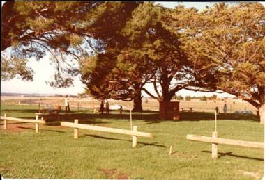
On 4th August 1978 the construction of the Goonawarra Estate commenced. The estate was formerly known as the Goonawarra Farm and overlooked the Sunbury farm and the Jacksons Creek valley. Plans for the new development included a golf course, houses, community and recreational facilities. The golf course opened in 1980 and the housing construction continued throughout the last two decades of the twentieth century and into the twenty first century.A coloured photograph of a barbecue and picnic area at Goonawarra. The photograph shows the Stage 3 development of the area.goona warra golf club, goonawarra farm, goonawarra housing estate, sharkey, robert b., kilkenny homes, craftsmen homes., australian ideas homes pty.ltd., glamor homes, villa bella homes, george evans collection -
 Sunbury Family History and Heritage Society Inc.
Photograph, School Camp, 1988
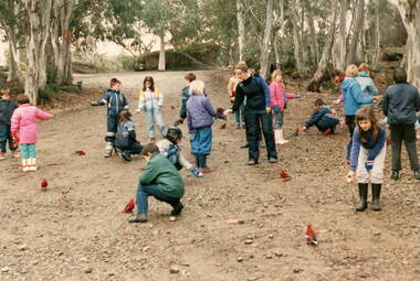
The photograph was taken when the students from Bulla and Mickleham Primary Schools combined to attend a camp at Beechworth in 1988. During that time the children were engaged in a number of different outdoor activities as a component of their outdoor education. Recognising some of the native birds of the area was one of their activities where the children experiences the birds actually landing on them.The varied activities that the children engaged in at the school camp helped to give them a better appreciation and understanding of the natural environment. A non-digital coloured photograph of a group of children with some adults in a bushland area, trying to encourage a flock of crimson rosellas to come closer by feeding them.school camps, beechworth, native birds, crimson rosellas -
Whitehorse Historical Society Inc.
Map, Municipality of Nunawading, c1950
Plan No 234, compiled and photo-lithographed at the Melbourne and Metropolitan Board of Works under the direction of G.R. McGowan, Chief Surveyor.Plan No 234, compiled and photo-lithographed at the Melbourne and Metropolitan Board of Works under the direction of G.R. McGowan, Chief Surveyor. Covers the area each Side of Canterbury Road from Orchard Grove to Vernon Street. Includes detail of creeks.Plan No 234, compiled and photo-lithographed at the Melbourne and Metropolitan Board of Works under the direction of G.R. McGowan, Chief Surveyor. blackburn south, gardiners creek, blackburn, blackburn creeklands -
 Bacchus Marsh & District Historical Society
Map, Bacchus Marsh Estate sold 30th June 1888 and sold 28 December 1895
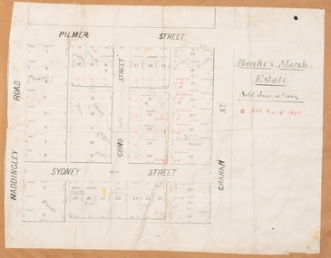
Blocks of land in this area of Bacchus Marsh were sold in lots between 1888 and the late 1890s. This map shows sales made in 1888 and 1895.Single page map showing allotments of land bounded by Pilmer Street, Graham Street, Sydney Street and Maddingley Road (Grant Street) in Bacchus Marsh.The area is dissected by Como Street down the central area. 43 blocks of land are shown with the names of buyers or sellers in 1888 written in black in. Buyers or sellers for December 1895 are written in red ink. Part of a set of maps which are pasted into a bound volume containing 76 maps or plans in total. High resolution digital image stored on BMDHS computer network. bacchus marsh victoria maps, land sales bacchus marsh, pilmer street bacchus marsh, graham street bacchus marsh, sydney street bacchus marsh, como street bacchus marsh, maddingley road bacchus marsh, grant street bacchus marsh -
Glenelg Shire Council Cultural Collection
Photograph - Photograph - Aerial view of the Port of Portland from the south-west, c. 1967
Port of Portland Authority archives.Front: (no inscriptions) Back: Area available for silo extension and storageport of portland archives -
 Ringwood and District Historical Society
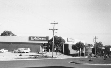
Photograph, McEwans Ringwood New shopping area 1984
Written on back of photograph, "McEwans 1984. New shopping area." -
 8th/13th Victorian Mounted Rifles Regimental Collection
Photograph
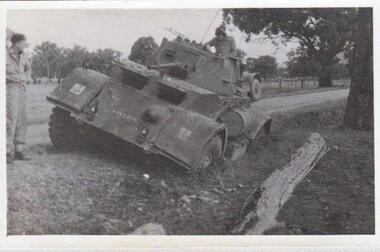
The 8th/13th Victorian Mounted Rifles was raised as a regiment of the Royal Australian Armoured Corps on 1 May 1948 with Headquarters in Melbourne and squadrons in Sale, Benalla/Wangaratta and Albury. In 1955 Regimental Headquarters moved to Wangaratta and a second squadron was located at Albury. The Sale squadron transferred to 4th/19th Prince of Wales’s Light Horse. In 1977 8/13 VMR Regiment was reduced to an independent squadron A Squadron 8th/13th Victorian Mounted Rifles and in 1991 was linked with 4th/19th Prince of Wales’s Light Horse forming the VMR Squadron of that regiment.Collection of photographs showing early evolution of an armoured regiment of the Citizen Forces as it progressed from WWII equipment and uniforms to post-war equipment and uniforms. Silver regimental hat badges are worn in place of Rising Sun badge.Black and white photograph of Staghound Armoured Car heavily bogged on exercise in Chiltern Forest near Albury. Has formation sign of 2nd Armoured Brigade on right mudguard." 1956 Staghound Armrd ( sic ) exercise in Chiltern / Rutherglen area " -
 8th/13th Victorian Mounted Rifles Regimental Collection
Photograph
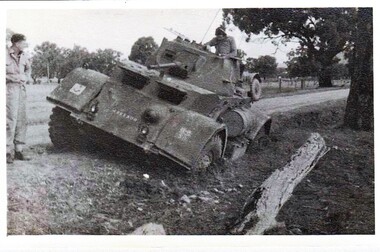
Collection of photographs showing early evolution of an armoured regiment of the Citizen Forces as it progressed from WWII equipment and uniforms to post-war equipment and uniforms. Silver regimental hat badges are worn in place of Rising Sun badge.Unique collection of photographs showing the first years of an armoured regiment of the post-Second World War era Citizen Military Forces showing equipment, uniforms, training and social activity and some personalities.Black and white photograph of Armoured Car bogged on side of road. Tactical sign of 2nd Armoured Brigade on right mudguard." Staghound Armoured car 1956' Exercise in Chiltern/ Rutherglen area." -
 Kiewa Valley Historical Society
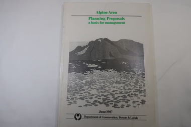
Book - Book - Alpine Area - Department of Conservation, Forests & Lands, Alpine Area / Planning Proposals / a basis for management. 1987
It is the policy of the Government that most of the State's alpine area will be proclaimed as an Alpine National Park, which would complement the Kosciusko National Park in N.S.W.. This is yet to be achieved (1987), however there is a need for sound, efficient and coordinated management based on the area's natural features, values and uses. Planning is proceeding on this basis.Victoria's alpine area is one of the State's most outstanding and spectacular natural areas. It is noted for its diverse plant and animal life, scenery, recreation opportunities and as a water catchment. This country is at the upper end of the Kiewa Valley and the planning for it is of interest to the Kiewa Valley inhabitants.White bound book with green print for title at the top, black & white picture and black print at the bottom for the name of the government authority publishing the book.143 pages with fold out map after page 7. The map is coloured green to indicate the planning area.alpine area, bogong national park, victorian department of conservation forests & lands -
 Narre Warren and District Family History Group
Booklet, Narre Warren & District Family History Group Inc, Casey Cardinia Collection - Nar Nar Goon Information File, 2005
Nar Nar Goon, a town in Gippsland, Victoria, has a rich history dating back to the mid-19th century. Originally part of the Kulin nation, the area was home to the Boon Wurrung people. The name "Nar Nar Goon" is believed to come from a Boonwurrung word referring to either the koala or the rakali. European settlement began with the establishment of the Mount Ararat pastoral run in 1844, followed by land sales in the 1850s and 1860s. Many settlers came from Ireland, particularly from the Monteagle estate in Limerick. The arrival of the railway in 1881 was a turning point, facilitating timber and agricultural industries. Several sawmills operated in the area, transporting timber via wooden tramways to the railway station. By the early 20th century, Nar Nar Goon had developed into a thriving township with a general store, hotel, butcher, baker, and garage. The town had strong Catholic roots, with a church opening in 1905. Over time, timber milling declined, and dairy farming became the dominant industry. In 2021, part of Nar Nar Goon was annexed to form the new suburb of Pakenham East. Today, Nar Nar Goon is known for its murals, historical buildings, and community spirit. It remains a small but significant town in Victoria’s history. [AI generated text]Display book containing a table of contents and various newspaper clippings and other information pertaining to the Nar Nar Goon area.non-fictionnar nar goon (vic.), nar nar goon (vic.) -- history, bernie byrne, jack egan, mark & sylvia jones, daisy lia, bill doherty, michael o'brien, joan & frank lindsay, paddy henwood, bob rose, harry james, ray coombs, jack payroll, deb bramley, nar nar goon-maryknoll cricket club, john byrne, bernie dingle, jan van steensel, len & mary bramley, kylie shanks, bill bickerton, james dore, red gem potatoes, brydie cunningham -
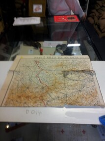 Running Rabbits Military Museum operated by the Upwey Belgrave RSL Sub Branch
Map
Area around Ypresdocuments, ww1, general -
University of Melbourne, Burnley Campus Archives
Photograph, James Leslie Provan, Burnley 1942 Album Page 2, 1942-1943
Entrance to Agrostology area.agrostology, burnley, 1942, j.l. provan -
University of Melbourne, Burnley Campus Archives
Photograph - Black and white print, 49/13, 1947
Hoeing in Agrostology area?hoeing, agrostology, e. m. gibson collection